Place
<a href="https://baza.polonika.pl/en/obiekty?countries%5B0%5D=1418&provinceLvl1%5B0%5D=1441&provinceLvl2%5B0%5D=5854&cities%5B0%5D=66304">Łomna Górna</a> (<a href="https://baza.polonika.pl/en/obiekty?countries%5B0%5D=1418">Czech Republic</a>, <a href="https://baza.polonika.pl/en/obiekty?countries%5B0%5D=1418&provinceLvl1%5B0%5D=1441">kraj morawsko-śląski</a>, <a href="https://baza.polonika.pl/en/obiekty?countries%5B0%5D=1418&provinceLvl1%5B0%5D=1441&provinceLvl2%5B0%5D=5854">okręg Frydek-Mistek</a>) <a href="https://baza.polonika.pl/en/obiekty?countries%5B0%5D=40&provinceLvl1%5B0%5D=1391&provinceLvl2%5B0%5D=7054&cities%5B0%5D=67840">Brou-sur-Chantereine</a> (<a href="https://baza.polonika.pl/en/obiekty?countries%5B0%5D=40">France</a>, <a href="https://baza.polonika.pl/en/obiekty?countries%5B0%5D=40&provinceLvl1%5B0%5D=1391">region Ile-de-France</a>, <a href="https://baza.polonika.pl/en/obiekty?countries%5B0%5D=40&provinceLvl1%5B0%5D=1391&provinceLvl2%5B0%5D=7054">departament Sekwana i Marna</a>) <a href="https://baza.polonika.pl/en/obiekty?countries%5B0%5D=41&provinceLvl1%5B0%5D=1997&provinceLvl2%5B0%5D=7113&cities%5B0%5D=2816">Optowa</a> (<a href="https://baza.polonika.pl/en/obiekty?countries%5B0%5D=41">Ukraine</a>, <a href="https://baza.polonika.pl/en/obiekty?countries%5B0%5D=41&provinceLvl1%5B0%5D=1997">obwód wołyński</a>, <a href="https://baza.polonika.pl/en/obiekty?countries%5B0%5D=41&provinceLvl1%5B0%5D=1997&provinceLvl2%5B0%5D=7113">rejon kamińsko-kaszirski</a>) <a href="https://baza.polonika.pl/en/obiekty?countries%5B0%5D=41&provinceLvl1%5B0%5D=1305&provinceLvl2%5B0%5D=1400&cities%5B0%5D=7168">Ostrowczyk</a> (<a href="https://baza.polonika.pl/en/obiekty?countries%5B0%5D=41">Ukraine</a>, <a href="https://baza.polonika.pl/en/obiekty?countries%5B0%5D=41&provinceLvl1%5B0%5D=1305">obwód tarnopolski</a>, <a href="https://baza.polonika.pl/en/obiekty?countries%5B0%5D=41&provinceLvl1%5B0%5D=1305&provinceLvl2%5B0%5D=1400">rejon tarnopolski</a>) <a href="https://baza.polonika.pl/en/obiekty?countries%5B0%5D=1246&provinceLvl1%5B0%5D=1348&provinceLvl2%5B0%5D=7423&cities%5B0%5D=7424">Dudzicze</a> (<a href="https://baza.polonika.pl/en/obiekty?countries%5B0%5D=1246">Belarus</a>, <a href="https://baza.polonika.pl/en/obiekty?countries%5B0%5D=1246&provinceLvl1%5B0%5D=1348">obwód miński</a>, <a href="https://baza.polonika.pl/en/obiekty?countries%5B0%5D=1246&provinceLvl1%5B0%5D=1348&provinceLvl2%5B0%5D=7423">rejon puchowicki</a>) <a href="https://baza.polonika.pl/en/obiekty?countries%5B0%5D=1246&provinceLvl1%5B0%5D=2015&provinceLvl2%5B0%5D=5768&cities%5B0%5D=10496">Sopoćkinie</a> (<a href="https://baza.polonika.pl/en/obiekty?countries%5B0%5D=1246">Belarus</a>, <a href="https://baza.polonika.pl/en/obiekty?countries%5B0%5D=1246&provinceLvl1%5B0%5D=2015">obwód grodzieński</a>, <a href="https://baza.polonika.pl/en/obiekty?countries%5B0%5D=1246&provinceLvl1%5B0%5D=2015&provinceLvl2%5B0%5D=5768">rejon grodzieński</a>) <a href="https://baza.polonika.pl/en/obiekty?countries%5B0%5D=1426&provinceLvl1%5B0%5D=1427&provinceLvl2%5B0%5D=1428&cities%5B0%5D=11008">Borejkowszczyzna</a> (<a href="https://baza.polonika.pl/en/obiekty?countries%5B0%5D=1426">Lithuania</a>, <a href="https://baza.polonika.pl/en/obiekty?countries%5B0%5D=1426&provinceLvl1%5B0%5D=1427">okręg wileński</a>, <a href="https://baza.polonika.pl/en/obiekty?countries%5B0%5D=1426&provinceLvl1%5B0%5D=1427&provinceLvl2%5B0%5D=1428">rejon wileński</a>) <a href="https://baza.polonika.pl/en/obiekty?countries%5B0%5D=41&provinceLvl1%5B0%5D=49846&provinceLvl2%5B0%5D=6588&cities%5B0%5D=45824">Jarynówka</a> (<a href="https://baza.polonika.pl/en/obiekty?countries%5B0%5D=41">Ukraine</a>, <a href="https://baza.polonika.pl/en/obiekty?countries%5B0%5D=41&provinceLvl1%5B0%5D=49846">obwód rówieński</a>, <a href="https://baza.polonika.pl/en/obiekty?countries%5B0%5D=41&provinceLvl1%5B0%5D=49846&provinceLvl2%5B0%5D=6588">rejon rówieński</a>) <a href="https://baza.polonika.pl/en/obiekty?countries%5B0%5D=41&provinceLvl1%5B0%5D=47614&provinceLvl2%5B0%5D=47615&cities%5B0%5D=47616">Starobielsk</a> (<a href="https://baza.polonika.pl/en/obiekty?countries%5B0%5D=41">Ukraine</a>, <a href="https://baza.polonika.pl/en/obiekty?countries%5B0%5D=41&provinceLvl1%5B0%5D=47614">obwód ługański</a>, <a href="https://baza.polonika.pl/en/obiekty?countries%5B0%5D=41&provinceLvl1%5B0%5D=47614&provinceLvl2%5B0%5D=47615">rejon starobielski</a>) <a href="https://baza.polonika.pl/en/obiekty?countries%5B0%5D=2097&provinceLvl1%5B0%5D=9872&provinceLvl2%5B0%5D=45642&cities%5B0%5D=64512">Täuffelen</a> (<a href="https://baza.polonika.pl/en/obiekty?countries%5B0%5D=2097">Switzerland</a>, <a href="https://baza.polonika.pl/en/obiekty?countries%5B0%5D=2097&provinceLvl1%5B0%5D=9872">kanton Bern</a>, <a href="https://baza.polonika.pl/en/obiekty?countries%5B0%5D=2097&provinceLvl1%5B0%5D=9872&provinceLvl2%5B0%5D=45642">okręg Seeland</a>) <a href="https://baza.polonika.pl/en/obiekty?countries%5B0%5D=1418&provinceLvl1%5B0%5D=1441&provinceLvl2%5B0%5D=1442&cities%5B0%5D=66305">Rychwałd</a> (<a href="https://baza.polonika.pl/en/obiekty?countries%5B0%5D=1418">Czech Republic</a>, <a href="https://baza.polonika.pl/en/obiekty?countries%5B0%5D=1418&provinceLvl1%5B0%5D=1441">kraj morawsko-śląski</a>, <a href="https://baza.polonika.pl/en/obiekty?countries%5B0%5D=1418&provinceLvl1%5B0%5D=1441&provinceLvl2%5B0%5D=1442">okręg Karwina</a>) <a href="https://baza.polonika.pl/en/obiekty?countries%5B0%5D=1385&provinceLvl1%5B0%5D=9648&provinceLvl2%5B0%5D=66816&cities%5B0%5D=66817">International Falls</a> (<a href="https://baza.polonika.pl/en/obiekty?countries%5B0%5D=1385">United States of America (USA)</a>, <a href="https://baza.polonika.pl/en/obiekty?countries%5B0%5D=1385&provinceLvl1%5B0%5D=9648">stan Minnesota</a>, <a href="https://baza.polonika.pl/en/obiekty?countries%5B0%5D=1385&provinceLvl1%5B0%5D=9648&provinceLvl2%5B0%5D=66816">Koochiching</a>) <a href="https://baza.polonika.pl/en/obiekty?countries%5B0%5D=40&provinceLvl1%5B0%5D=6850&provinceLvl2%5B0%5D=26732&cities%5B0%5D=67841">Saint-Dizier</a> (<a href="https://baza.polonika.pl/en/obiekty?countries%5B0%5D=40">France</a>, <a href="https://baza.polonika.pl/en/obiekty?countries%5B0%5D=40&provinceLvl1%5B0%5D=6850">region Grand Est</a>, <a href="https://baza.polonika.pl/en/obiekty?countries%5B0%5D=40&provinceLvl1%5B0%5D=6850&provinceLvl2%5B0%5D=26732">departament Górna Marna</a>) <a href="https://baza.polonika.pl/en/obiekty?countries%5B0%5D=41&provinceLvl1%5B0%5D=49846&provinceLvl2%5B0%5D=6588&cities%5B0%5D=2817">Janowa Dolina</a> (<a href="https://baza.polonika.pl/en/obiekty?countries%5B0%5D=41">Ukraine</a>, <a href="https://baza.polonika.pl/en/obiekty?countries%5B0%5D=41&provinceLvl1%5B0%5D=49846">obwód rówieński</a>, <a href="https://baza.polonika.pl/en/obiekty?countries%5B0%5D=41&provinceLvl1%5B0%5D=49846&provinceLvl2%5B0%5D=6588">rejon rówieński</a>) <a href="https://baza.polonika.pl/en/obiekty?countries%5B0%5D=41&provinceLvl1%5B0%5D=1994&provinceLvl2%5B0%5D=7112&cities%5B0%5D=7169">Ozarzyńce</a> (<a href="https://baza.polonika.pl/en/obiekty?countries%5B0%5D=41">Ukraine</a>, <a href="https://baza.polonika.pl/en/obiekty?countries%5B0%5D=41&provinceLvl1%5B0%5D=1994">obwód winnicki</a>, <a href="https://baza.polonika.pl/en/obiekty?countries%5B0%5D=41&provinceLvl1%5B0%5D=1994&provinceLvl2%5B0%5D=7112">rejon mohylewsko-podolski</a>) <a href="https://baza.polonika.pl/en/obiekty?countries%5B0%5D=1246&provinceLvl1%5B0%5D=1348&provinceLvl2%5B0%5D=5787&cities%5B0%5D=7425">Duszkowo</a> (<a href="https://baza.polonika.pl/en/obiekty?countries%5B0%5D=1246">Belarus</a>, <a href="https://baza.polonika.pl/en/obiekty?countries%5B0%5D=1246&provinceLvl1%5B0%5D=1348">obwód miński</a>, <a href="https://baza.polonika.pl/en/obiekty?countries%5B0%5D=1246&provinceLvl1%5B0%5D=1348&provinceLvl2%5B0%5D=5787">rejon wołożyński</a>) <a href="https://baza.polonika.pl/en/obiekty?countries%5B0%5D=1385&provinceLvl1%5B0%5D=7696&provinceLvl2%5B0%5D=9728&cities%5B0%5D=9729">Pittsburgh</a> (<a href="https://baza.polonika.pl/en/obiekty?countries%5B0%5D=1385">United States of America (USA)</a>, <a href="https://baza.polonika.pl/en/obiekty?countries%5B0%5D=1385&provinceLvl1%5B0%5D=7696">stan Pennsylwania</a>, <a href="https://baza.polonika.pl/en/obiekty?countries%5B0%5D=1385&provinceLvl1%5B0%5D=7696&provinceLvl2%5B0%5D=9728">hrabstwo Allegheny</a>) <a href="https://baza.polonika.pl/en/obiekty?countries%5B0%5D=1246&provinceLvl1%5B0%5D=2015&provinceLvl2%5B0%5D=7291&cities%5B0%5D=10497">Spondy</a> (<a href="https://baza.polonika.pl/en/obiekty?countries%5B0%5D=1246">Belarus</a>, <a href="https://baza.polonika.pl/en/obiekty?countries%5B0%5D=1246&provinceLvl1%5B0%5D=2015">obwód grodzieński</a>, <a href="https://baza.polonika.pl/en/obiekty?countries%5B0%5D=1246&provinceLvl1%5B0%5D=2015&provinceLvl2%5B0%5D=7291">rejon ostrowiecki</a>) <a href="https://baza.polonika.pl/en/obiekty?countries%5B0%5D=1426&provinceLvl1%5B0%5D=1427&provinceLvl2%5B0%5D=11518&cities%5B0%5D=11521">Dowgierdziszki</a> (<a href="https://baza.polonika.pl/en/obiekty?countries%5B0%5D=1426">Lithuania</a>, <a href="https://baza.polonika.pl/en/obiekty?countries%5B0%5D=1426&provinceLvl1%5B0%5D=1427">okręg wileński</a>, <a href="https://baza.polonika.pl/en/obiekty?countries%5B0%5D=1426&provinceLvl1%5B0%5D=1427&provinceLvl2%5B0%5D=11518">rejon elektreński</a>) <a href="https://baza.polonika.pl/en/obiekty?countries%5B0%5D=9&provinceLvl1%5B0%5D=1310&provinceLvl2%5B0%5D=14336&cities%5B0%5D=14337">Fulda</a> (<a href="https://baza.polonika.pl/en/obiekty?countries%5B0%5D=9">Germany</a>, <a href="https://baza.polonika.pl/en/obiekty?countries%5B0%5D=9&provinceLvl1%5B0%5D=1310">kraj związkowy Hesja</a>, <a href="https://baza.polonika.pl/en/obiekty?countries%5B0%5D=9&provinceLvl1%5B0%5D=1310&provinceLvl2%5B0%5D=14336">lk. Fulda</a>) <a href="https://baza.polonika.pl/en/obiekty?countries%5B0%5D=41&provinceLvl1%5B0%5D=5865&provinceLvl2%5B0%5D=15872&cities%5B0%5D=15873">Susły</a> (<a href="https://baza.polonika.pl/en/obiekty?countries%5B0%5D=41">Ukraine</a>, <a href="https://baza.polonika.pl/en/obiekty?countries%5B0%5D=41&provinceLvl1%5B0%5D=5865">obwód żytomierski</a>, <a href="https://baza.polonika.pl/en/obiekty?countries%5B0%5D=41&provinceLvl1%5B0%5D=5865&provinceLvl2%5B0%5D=15872">rejon zwiahelski</a>) <a href="https://baza.polonika.pl/en/obiekty?countries%5B0%5D=11361&provinceLvl2%5B0%5D=18176&cities%5B0%5D=18177">Bratysława</a> (<a href="https://baza.polonika.pl/en/obiekty?countries%5B0%5D=11361">Slovakia</a>, <a href="https://baza.polonika.pl/en/obiekty?countries%5B0%5D=11361&provinceLvl2%5B0%5D=18176">okręg bratysławski</a>) <a href="https://baza.polonika.pl/en/obiekty?countries%5B0%5D=41&provinceLvl1%5B0%5D=1997&provinceLvl2%5B0%5D=2556&cities%5B0%5D=45825">Koszyszcze</a> (<a href="https://baza.polonika.pl/en/obiekty?countries%5B0%5D=41">Ukraine</a>, <a href="https://baza.polonika.pl/en/obiekty?countries%5B0%5D=41&provinceLvl1%5B0%5D=1997">obwód wołyński</a>, <a href="https://baza.polonika.pl/en/obiekty?countries%5B0%5D=41&provinceLvl1%5B0%5D=1997&provinceLvl2%5B0%5D=2556">rejon łucki</a>) <a href="https://baza.polonika.pl/en/obiekty?countries%5B0%5D=11409&provinceLvl1%5B0%5D=46847&provinceLvl2%5B0%5D=46848&cities%5B0%5D=46849">Dunedin</a> (<a href="https://baza.polonika.pl/en/obiekty?countries%5B0%5D=11409">New Zealand</a>, <a href="https://baza.polonika.pl/en/obiekty?countries%5B0%5D=11409&provinceLvl1%5B0%5D=46847">Wyspa Południowa</a>, <a href="https://baza.polonika.pl/en/obiekty?countries%5B0%5D=11409&provinceLvl1%5B0%5D=46847&provinceLvl2%5B0%5D=46848">Otago</a>) <a href="https://baza.polonika.pl/en/obiekty?countries%5B0%5D=41&provinceLvl1%5B0%5D=47614&provinceLvl2%5B0%5D=47615&cities%5B0%5D=47617">Czymirówka</a> (<a href="https://baza.polonika.pl/en/obiekty?countries%5B0%5D=41">Ukraine</a>, <a href="https://baza.polonika.pl/en/obiekty?countries%5B0%5D=41&provinceLvl1%5B0%5D=47614">obwód ługański</a>, <a href="https://baza.polonika.pl/en/obiekty?countries%5B0%5D=41&provinceLvl1%5B0%5D=47614&provinceLvl2%5B0%5D=47615">rejon starobielski</a>) <a href="https://baza.polonika.pl/en/obiekty?countries%5B0%5D=2097&provinceLvl1%5B0%5D=13843&provinceLvl2%5B0%5D=64507&cities%5B0%5D=64513">Münchenbuchsee</a> (<a href="https://baza.polonika.pl/en/obiekty?countries%5B0%5D=2097">Switzerland</a>, <a href="https://baza.polonika.pl/en/obiekty?countries%5B0%5D=2097&provinceLvl1%5B0%5D=13843">kanton Berno</a>, <a href="https://baza.polonika.pl/en/obiekty?countries%5B0%5D=2097&provinceLvl1%5B0%5D=13843&provinceLvl2%5B0%5D=64507">okręg Bern-Mitteland</a>) <a href="https://baza.polonika.pl/en/obiekty?countries%5B0%5D=41&provinceLvl1%5B0%5D=1305&provinceLvl2%5B0%5D=1400&cities%5B0%5D=770">Baworów</a> (<a href="https://baza.polonika.pl/en/obiekty?countries%5B0%5D=41">Ukraine</a>, <a href="https://baza.polonika.pl/en/obiekty?countries%5B0%5D=41&provinceLvl1%5B0%5D=1305">obwód tarnopolski</a>, <a href="https://baza.polonika.pl/en/obiekty?countries%5B0%5D=41&provinceLvl1%5B0%5D=1305&provinceLvl2%5B0%5D=1400">rejon tarnopolski</a>) <a href="https://baza.polonika.pl/en/obiekty?countries%5B0%5D=1418&provinceLvl1%5B0%5D=1441&provinceLvl2%5B0%5D=5854&cities%5B0%5D=66306">Rzeka</a> (<a href="https://baza.polonika.pl/en/obiekty?countries%5B0%5D=1418">Czech Republic</a>, <a href="https://baza.polonika.pl/en/obiekty?countries%5B0%5D=1418&provinceLvl1%5B0%5D=1441">kraj morawsko-śląski</a>, <a href="https://baza.polonika.pl/en/obiekty?countries%5B0%5D=1418&provinceLvl1%5B0%5D=1441&provinceLvl2%5B0%5D=5854">okręg Frydek-Mistek</a>) <a href="https://baza.polonika.pl/en/obiekty?countries%5B0%5D=41&provinceLvl1%5B0%5D=2068&provinceLvl2%5B0%5D=5214&cities%5B0%5D=2050">Dytiatyn</a> (<a href="https://baza.polonika.pl/en/obiekty?countries%5B0%5D=41">Ukraine</a>, <a href="https://baza.polonika.pl/en/obiekty?countries%5B0%5D=41&provinceLvl1%5B0%5D=2068">obwód iwanofrankiwski</a>, <a href="https://baza.polonika.pl/en/obiekty?countries%5B0%5D=41&provinceLvl1%5B0%5D=2068&provinceLvl2%5B0%5D=5214">rejon iwanofrankiwski</a>) <a href="https://baza.polonika.pl/en/obiekty?countries%5B0%5D=40&provinceLvl1%5B0%5D=1391&provinceLvl2%5B0%5D=48003&cities%5B0%5D=67842">Bobigny</a> (<a href="https://baza.polonika.pl/en/obiekty?countries%5B0%5D=40">France</a>, <a href="https://baza.polonika.pl/en/obiekty?countries%5B0%5D=40&provinceLvl1%5B0%5D=1391">region Ile-de-France</a>, <a href="https://baza.polonika.pl/en/obiekty?countries%5B0%5D=40&provinceLvl1%5B0%5D=1391&provinceLvl2%5B0%5D=48003">departament Sekwana-Saint-Denis</a>) <a href="https://baza.polonika.pl/en/obiekty?countries%5B0%5D=41&provinceLvl1%5B0%5D=1997&provinceLvl2%5B0%5D=2556&cities%5B0%5D=2818">Kołki</a> (<a href="https://baza.polonika.pl/en/obiekty?countries%5B0%5D=41">Ukraine</a>, <a href="https://baza.polonika.pl/en/obiekty?countries%5B0%5D=41&provinceLvl1%5B0%5D=1997">obwód wołyński</a>, <a href="https://baza.polonika.pl/en/obiekty?countries%5B0%5D=41&provinceLvl1%5B0%5D=1997&provinceLvl2%5B0%5D=2556">rejon łucki</a>) <a href="https://baza.polonika.pl/en/obiekty?cities%5B0%5D=6658">Ratno</a> <a href="https://baza.polonika.pl/en/obiekty?cities%5B0%5D=7170">Leszniów</a> <a href="https://baza.polonika.pl/en/obiekty?countries%5B0%5D=1246&provinceLvl1%5B0%5D=1351&provinceLvl2%5B0%5D=9690&cities%5B0%5D=9730">Jody</a> (<a href="https://baza.polonika.pl/en/obiekty?countries%5B0%5D=1246">Belarus</a>, <a href="https://baza.polonika.pl/en/obiekty?countries%5B0%5D=1246&provinceLvl1%5B0%5D=1351">obwód witebski</a>, <a href="https://baza.polonika.pl/en/obiekty?countries%5B0%5D=1246&provinceLvl1%5B0%5D=1351&provinceLvl2%5B0%5D=9690">rejon szarkowszczyński</a>) <a href="https://baza.polonika.pl/en/obiekty?countries%5B0%5D=1246&provinceLvl1%5B0%5D=1351&provinceLvl2%5B0%5D=5800&cities%5B0%5D=10498">Stankowicze</a> (<a href="https://baza.polonika.pl/en/obiekty?countries%5B0%5D=1246">Belarus</a>, <a href="https://baza.polonika.pl/en/obiekty?countries%5B0%5D=1246&provinceLvl1%5B0%5D=1351">obwód witebski</a>, <a href="https://baza.polonika.pl/en/obiekty?countries%5B0%5D=1246&provinceLvl1%5B0%5D=1351&provinceLvl2%5B0%5D=5800">rejon brasławski</a>) <a href="https://baza.polonika.pl/en/obiekty?countries%5B0%5D=1426&provinceLvl1%5B0%5D=1427&provinceLvl2%5B0%5D=11994&cities%5B0%5D=11522">Olkieniki</a> (<a href="https://baza.polonika.pl/en/obiekty?countries%5B0%5D=1426">Lithuania</a>, <a href="https://baza.polonika.pl/en/obiekty?countries%5B0%5D=1426&provinceLvl1%5B0%5D=1427">okręg wileński</a>, <a href="https://baza.polonika.pl/en/obiekty?countries%5B0%5D=1426&provinceLvl1%5B0%5D=1427&provinceLvl2%5B0%5D=11994">rejon orański</a>) <a href="https://baza.polonika.pl/en/obiekty?countries%5B0%5D=40&provinceLvl1%5B0%5D=6779&provinceLvl2%5B0%5D=12687&cities%5B0%5D=13826">Grenoble</a> (<a href="https://baza.polonika.pl/en/obiekty?countries%5B0%5D=40">France</a>, <a href="https://baza.polonika.pl/en/obiekty?countries%5B0%5D=40&provinceLvl1%5B0%5D=6779">region Owernia-Rodan-Alpy</a>, <a href="https://baza.polonika.pl/en/obiekty?countries%5B0%5D=40&provinceLvl1%5B0%5D=6779&provinceLvl2%5B0%5D=12687">departament Isère</a>) <a href="https://baza.polonika.pl/en/obiekty?countries%5B0%5D=17919&provinceLvl2%5B0%5D=17920&cities%5B0%5D=17922">Tirana</a> (<a href="https://baza.polonika.pl/en/obiekty?countries%5B0%5D=17919">Albania</a>, <a href="https://baza.polonika.pl/en/obiekty?countries%5B0%5D=17919&provinceLvl2%5B0%5D=17920">okreg Tirana</a>) <a href="https://baza.polonika.pl/en/obiekty?countries%5B0%5D=13907&provinceLvl2%5B0%5D=45569&cities%5B0%5D=45570">Utrecht</a> (<a href="https://baza.polonika.pl/en/obiekty?countries%5B0%5D=13907">Netherlands</a>, <a href="https://baza.polonika.pl/en/obiekty?countries%5B0%5D=13907&provinceLvl2%5B0%5D=45569">prowincja Utrecht</a>) <a href="https://baza.polonika.pl/en/obiekty?countries%5B0%5D=41&provinceLvl1%5B0%5D=49846&provinceLvl2%5B0%5D=6588&cities%5B0%5D=45826">Lidawka</a> (<a href="https://baza.polonika.pl/en/obiekty?countries%5B0%5D=41">Ukraine</a>, <a href="https://baza.polonika.pl/en/obiekty?countries%5B0%5D=41&provinceLvl1%5B0%5D=49846">obwód rówieński</a>, <a href="https://baza.polonika.pl/en/obiekty?countries%5B0%5D=41&provinceLvl1%5B0%5D=49846&provinceLvl2%5B0%5D=6588">rejon rówieński</a>) <a href="https://baza.polonika.pl/en/obiekty?countries%5B0%5D=41&provinceLvl1%5B0%5D=1997&provinceLvl2%5B0%5D=1998&cities%5B0%5D=47618">Wierzbiczno</a> (<a href="https://baza.polonika.pl/en/obiekty?countries%5B0%5D=41">Ukraine</a>, <a href="https://baza.polonika.pl/en/obiekty?countries%5B0%5D=41&provinceLvl1%5B0%5D=1997">obwód wołyński</a>, <a href="https://baza.polonika.pl/en/obiekty?countries%5B0%5D=41&provinceLvl1%5B0%5D=1997&provinceLvl2%5B0%5D=1998">rejon kowelski</a>) <a href="https://baza.polonika.pl/en/obiekty?countries%5B0%5D=7323&provinceLvl1%5B0%5D=7341&provinceLvl2%5B0%5D=63996&cities%5B0%5D=64002">Kingston upon Hull</a> (<a href="https://baza.polonika.pl/en/obiekty?countries%5B0%5D=7323">United Kingdom</a>, <a href="https://baza.polonika.pl/en/obiekty?countries%5B0%5D=7323&provinceLvl1%5B0%5D=7341">Anglia</a>, <a href="https://baza.polonika.pl/en/obiekty?countries%5B0%5D=7323&provinceLvl1%5B0%5D=7341&provinceLvl2%5B0%5D=63996">Yorkshire and the Humber</a>) <a href="https://baza.polonika.pl/en/obiekty?countries%5B0%5D=1418&provinceLvl1%5B0%5D=1441&provinceLvl2%5B0%5D=5854&cities%5B0%5D=66307">Szobiszowice</a> (<a href="https://baza.polonika.pl/en/obiekty?countries%5B0%5D=1418">Czech Republic</a>, <a href="https://baza.polonika.pl/en/obiekty?countries%5B0%5D=1418&provinceLvl1%5B0%5D=1441">kraj morawsko-śląski</a>, <a href="https://baza.polonika.pl/en/obiekty?countries%5B0%5D=1418&provinceLvl1%5B0%5D=1441&provinceLvl2%5B0%5D=5854">okręg Frydek-Mistek</a>) <a href="https://baza.polonika.pl/en/obiekty?countries%5B0%5D=11361&provinceLvl1%5B0%5D=13169&provinceLvl2%5B0%5D=66818&cities%5B0%5D=66819">Spiskie Włochy</a> (<a href="https://baza.polonika.pl/en/obiekty?countries%5B0%5D=11361">Slovakia</a>, <a href="https://baza.polonika.pl/en/obiekty?countries%5B0%5D=11361&provinceLvl1%5B0%5D=13169">kraj koszycki (Kraj Košický)</a>, <a href="https://baza.polonika.pl/en/obiekty?countries%5B0%5D=11361&provinceLvl1%5B0%5D=13169&provinceLvl2%5B0%5D=66818">powiat Nowa Wieś Spiska</a>) <a href="https://baza.polonika.pl/en/obiekty?countries%5B0%5D=41&provinceLvl1%5B0%5D=1373&provinceLvl2%5B0%5D=1374&cities%5B0%5D=2051">Horpin</a> (<a href="https://baza.polonika.pl/en/obiekty?countries%5B0%5D=41">Ukraine</a>, <a href="https://baza.polonika.pl/en/obiekty?countries%5B0%5D=41&provinceLvl1%5B0%5D=1373">obwód lwowski</a>, <a href="https://baza.polonika.pl/en/obiekty?countries%5B0%5D=41&provinceLvl1%5B0%5D=1373&provinceLvl2%5B0%5D=1374">rejon lwowski</a>) <a href="https://baza.polonika.pl/en/obiekty?countries%5B0%5D=40&provinceLvl1%5B0%5D=6850&provinceLvl2%5B0%5D=26732&cities%5B0%5D=67843">Saint-Dizier</a> (<a href="https://baza.polonika.pl/en/obiekty?countries%5B0%5D=40">France</a>, <a href="https://baza.polonika.pl/en/obiekty?countries%5B0%5D=40&provinceLvl1%5B0%5D=6850">region Grand Est</a>, <a href="https://baza.polonika.pl/en/obiekty?countries%5B0%5D=40&provinceLvl1%5B0%5D=6850&provinceLvl2%5B0%5D=26732">departament Górna Marna</a>) <a href="https://baza.polonika.pl/en/obiekty?countries%5B0%5D=6837&provinceLvl2%5B0%5D=6913&cities%5B0%5D=6915">Lima</a> (<a href="https://baza.polonika.pl/en/obiekty?countries%5B0%5D=6837">Peru</a>, <a href="https://baza.polonika.pl/en/obiekty?countries%5B0%5D=6837&provinceLvl2%5B0%5D=6913">prowincja Lima</a>) <a href="https://baza.polonika.pl/en/obiekty?countries%5B0%5D=1246&provinceLvl1%5B0%5D=2015&provinceLvl2%5B0%5D=7426&cities%5B0%5D=7427">Dworzec</a> (<a href="https://baza.polonika.pl/en/obiekty?countries%5B0%5D=1246">Belarus</a>, <a href="https://baza.polonika.pl/en/obiekty?countries%5B0%5D=1246&provinceLvl1%5B0%5D=2015">obwód grodzieński</a>, <a href="https://baza.polonika.pl/en/obiekty?countries%5B0%5D=1246&provinceLvl1%5B0%5D=2015&provinceLvl2%5B0%5D=7426">rejon zdzięcielski</a>) <a href="https://baza.polonika.pl/en/obiekty?countries%5B0%5D=1385&provinceLvl1%5B0%5D=7681&provinceLvl2%5B0%5D=7682&cities%5B0%5D=7683">Boston</a> (<a href="https://baza.polonika.pl/en/obiekty?countries%5B0%5D=1385">United States of America (USA)</a>, <a href="https://baza.polonika.pl/en/obiekty?countries%5B0%5D=1385&provinceLvl1%5B0%5D=7681">stan Massachusetts</a>, <a href="https://baza.polonika.pl/en/obiekty?countries%5B0%5D=1385&provinceLvl1%5B0%5D=7681&provinceLvl2%5B0%5D=7682">hrabstwo Suffolk</a>) <a href="https://baza.polonika.pl/en/obiekty?countries%5B0%5D=1246&provinceLvl1%5B0%5D=2015&provinceLvl2%5B0%5D=7421&cities%5B0%5D=9731">Juraciszki</a> (<a href="https://baza.polonika.pl/en/obiekty?countries%5B0%5D=1246">Belarus</a>, <a href="https://baza.polonika.pl/en/obiekty?countries%5B0%5D=1246&provinceLvl1%5B0%5D=2015">obwód grodzieński</a>, <a href="https://baza.polonika.pl/en/obiekty?countries%5B0%5D=1246&provinceLvl1%5B0%5D=2015&provinceLvl2%5B0%5D=7421">rejon iwiejski</a>) <a href="https://baza.polonika.pl/en/obiekty?countries%5B0%5D=1246&provinceLvl1%5B0%5D=1351&provinceLvl2%5B0%5D=5800&cities%5B0%5D=10499">Stare Dworzyszcze</a> (<a href="https://baza.polonika.pl/en/obiekty?countries%5B0%5D=1246">Belarus</a>, <a href="https://baza.polonika.pl/en/obiekty?countries%5B0%5D=1246&provinceLvl1%5B0%5D=1351">obwód witebski</a>, <a href="https://baza.polonika.pl/en/obiekty?countries%5B0%5D=1246&provinceLvl1%5B0%5D=1351&provinceLvl2%5B0%5D=5800">rejon brasławski</a>) <a href="https://baza.polonika.pl/en/obiekty?countries%5B0%5D=41&provinceLvl1%5B0%5D=11266&provinceLvl2%5B0%5D=11268&cities%5B0%5D=11267">Dniepr</a> (<a href="https://baza.polonika.pl/en/obiekty?countries%5B0%5D=41">Ukraine</a>, <a href="https://baza.polonika.pl/en/obiekty?countries%5B0%5D=41&provinceLvl1%5B0%5D=11266">obwód dniepropetrowski</a>, <a href="https://baza.polonika.pl/en/obiekty?countries%5B0%5D=41&provinceLvl1%5B0%5D=11266&provinceLvl2%5B0%5D=11268">rejon dnieprzański</a>) <a href="https://baza.polonika.pl/en/obiekty?countries%5B0%5D=9&provinceLvl1%5B0%5D=1310&provinceLvl2%5B0%5D=14338&cities%5B0%5D=14339">Gießen</a> (<a href="https://baza.polonika.pl/en/obiekty?countries%5B0%5D=9">Germany</a>, <a href="https://baza.polonika.pl/en/obiekty?countries%5B0%5D=9&provinceLvl1%5B0%5D=1310">kraj związkowy Hesja</a>, <a href="https://baza.polonika.pl/en/obiekty?countries%5B0%5D=9&provinceLvl1%5B0%5D=1310&provinceLvl2%5B0%5D=14338">lk. Gießen</a>) <a href="https://baza.polonika.pl/en/obiekty?countries%5B0%5D=6966&provinceLvl1%5B0%5D=18433&provinceLvl2%5B0%5D=18434&cities%5B0%5D=18435">Tallinn</a> (<a href="https://baza.polonika.pl/en/obiekty?countries%5B0%5D=6966">Estonia</a>, <a href="https://baza.polonika.pl/en/obiekty?countries%5B0%5D=6966&provinceLvl1%5B0%5D=18433">prowincja Harjumaa</a>, <a href="https://baza.polonika.pl/en/obiekty?countries%5B0%5D=6966&provinceLvl1%5B0%5D=18433&provinceLvl2%5B0%5D=18434">gmina Tallinn</a>) <a href="https://baza.polonika.pl/en/obiekty?countries%5B0%5D=41&provinceLvl1%5B0%5D=49846&provinceLvl2%5B0%5D=6028&cities%5B0%5D=45827">Ludwikówka</a> (<a href="https://baza.polonika.pl/en/obiekty?countries%5B0%5D=41">Ukraine</a>, <a href="https://baza.polonika.pl/en/obiekty?countries%5B0%5D=41&provinceLvl1%5B0%5D=49846">obwód rówieński</a>, <a href="https://baza.polonika.pl/en/obiekty?countries%5B0%5D=41&provinceLvl1%5B0%5D=49846&provinceLvl2%5B0%5D=6028">rejon dubieński</a>) <a href="https://baza.polonika.pl/en/obiekty?countries%5B0%5D=41&provinceLvl1%5B0%5D=49846&provinceLvl2%5B0%5D=6588&cities%5B0%5D=47619">Zielony Dąb</a> (<a href="https://baza.polonika.pl/en/obiekty?countries%5B0%5D=41">Ukraine</a>, <a href="https://baza.polonika.pl/en/obiekty?countries%5B0%5D=41&provinceLvl1%5B0%5D=49846">obwód rówieński</a>, <a href="https://baza.polonika.pl/en/obiekty?countries%5B0%5D=41&provinceLvl1%5B0%5D=49846&provinceLvl2%5B0%5D=6588">rejon rówieński</a>) <a href="https://baza.polonika.pl/en/obiekty?countries%5B0%5D=7323&provinceLvl1%5B0%5D=7341&provinceLvl2%5B0%5D=63996&cities%5B0%5D=64003">Scarborough</a> (<a href="https://baza.polonika.pl/en/obiekty?countries%5B0%5D=7323">United Kingdom</a>, <a href="https://baza.polonika.pl/en/obiekty?countries%5B0%5D=7323&provinceLvl1%5B0%5D=7341">Anglia</a>, <a href="https://baza.polonika.pl/en/obiekty?countries%5B0%5D=7323&provinceLvl1%5B0%5D=7341&provinceLvl2%5B0%5D=63996">Yorkshire and the Humber</a>) <a href="https://baza.polonika.pl/en/obiekty?countries%5B0%5D=2097&provinceLvl1%5B0%5D=63404&provinceLvl2%5B0%5D=64514&cities%5B0%5D=64515">Chur</a> (<a href="https://baza.polonika.pl/en/obiekty?countries%5B0%5D=2097">Switzerland</a>, <a href="https://baza.polonika.pl/en/obiekty?countries%5B0%5D=2097&provinceLvl1%5B0%5D=63404">kanton Gryzonia</a>, <a href="https://baza.polonika.pl/en/obiekty?countries%5B0%5D=2097&provinceLvl1%5B0%5D=63404&provinceLvl2%5B0%5D=64514">okręg Plessur</a>) <a href="https://baza.polonika.pl/en/obiekty?countries%5B0%5D=1418&provinceLvl1%5B0%5D=1441&provinceLvl2%5B0%5D=5854&cities%5B0%5D=66308">Trzanowice</a> (<a href="https://baza.polonika.pl/en/obiekty?countries%5B0%5D=1418">Czech Republic</a>, <a href="https://baza.polonika.pl/en/obiekty?countries%5B0%5D=1418&provinceLvl1%5B0%5D=1441">kraj morawsko-śląski</a>, <a href="https://baza.polonika.pl/en/obiekty?countries%5B0%5D=1418&provinceLvl1%5B0%5D=1441&provinceLvl2%5B0%5D=5854">okręg Frydek-Mistek</a>) <a href="https://baza.polonika.pl/en/obiekty?countries%5B0%5D=41&provinceLvl1%5B0%5D=1997&provinceLvl2%5B0%5D=1998&cities%5B0%5D=2052">Mielniki</a> (<a href="https://baza.polonika.pl/en/obiekty?countries%5B0%5D=41">Ukraine</a>, <a href="https://baza.polonika.pl/en/obiekty?countries%5B0%5D=41&provinceLvl1%5B0%5D=1997">obwód wołyński</a>, <a href="https://baza.polonika.pl/en/obiekty?countries%5B0%5D=41&provinceLvl1%5B0%5D=1997&provinceLvl2%5B0%5D=1998">rejon kowelski</a>) <a href="https://baza.polonika.pl/en/obiekty?countries%5B0%5D=41&provinceLvl1%5B0%5D=1373&provinceLvl2%5B0%5D=2071&cities%5B0%5D=2820">Waręż</a> (<a href="https://baza.polonika.pl/en/obiekty?countries%5B0%5D=41">Ukraine</a>, <a href="https://baza.polonika.pl/en/obiekty?countries%5B0%5D=41&provinceLvl1%5B0%5D=1373">obwód lwowski</a>, <a href="https://baza.polonika.pl/en/obiekty?countries%5B0%5D=41&provinceLvl1%5B0%5D=1373&provinceLvl2%5B0%5D=2071">rejon szeptycki</a>) <a href="https://baza.polonika.pl/en/obiekty?countries%5B0%5D=41&provinceLvl1%5B0%5D=1373&provinceLvl2%5B0%5D=2071&cities%5B0%5D=6660">Rekliniec</a> (<a href="https://baza.polonika.pl/en/obiekty?countries%5B0%5D=41">Ukraine</a>, <a href="https://baza.polonika.pl/en/obiekty?countries%5B0%5D=41&provinceLvl1%5B0%5D=1373">obwód lwowski</a>, <a href="https://baza.polonika.pl/en/obiekty?countries%5B0%5D=41&provinceLvl1%5B0%5D=1373&provinceLvl2%5B0%5D=2071">rejon szeptycki</a>) <a href="https://baza.polonika.pl/en/obiekty?countries%5B0%5D=40&provinceLvl1%5B0%5D=6912&provinceLvl2%5B0%5D=6914&cities%5B0%5D=6916">Cholet</a> (<a href="https://baza.polonika.pl/en/obiekty?countries%5B0%5D=40">France</a>, <a href="https://baza.polonika.pl/en/obiekty?countries%5B0%5D=40&provinceLvl1%5B0%5D=6912">region Kraj Loary</a>, <a href="https://baza.polonika.pl/en/obiekty?countries%5B0%5D=40&provinceLvl1%5B0%5D=6912&provinceLvl2%5B0%5D=6914">departament Maine i Loara</a>) <a href="https://baza.polonika.pl/en/obiekty?countries%5B0%5D=41&provinceLvl1%5B0%5D=5865&provinceLvl2%5B0%5D=6907&cities%5B0%5D=7172">Lubar</a> (<a href="https://baza.polonika.pl/en/obiekty?countries%5B0%5D=41">Ukraine</a>, <a href="https://baza.polonika.pl/en/obiekty?countries%5B0%5D=41&provinceLvl1%5B0%5D=5865">obwód żytomierski</a>, <a href="https://baza.polonika.pl/en/obiekty?countries%5B0%5D=41&provinceLvl1%5B0%5D=5865&provinceLvl2%5B0%5D=6907">rejon żytomierski</a>) <a href="https://baza.polonika.pl/en/obiekty?countries%5B0%5D=1246&provinceLvl1%5B0%5D=2014&provinceLvl2%5B0%5D=9776&cities%5B0%5D=10500">Stolin</a> (<a href="https://baza.polonika.pl/en/obiekty?countries%5B0%5D=1246">Belarus</a>, <a href="https://baza.polonika.pl/en/obiekty?countries%5B0%5D=1246&provinceLvl1%5B0%5D=2014">obwód brzeski</a>, <a href="https://baza.polonika.pl/en/obiekty?countries%5B0%5D=1246&provinceLvl1%5B0%5D=2014&provinceLvl2%5B0%5D=9776">rejon stoliński</a>) <a href="https://baza.polonika.pl/en/obiekty?countries%5B0%5D=7582&provinceLvl2%5B0%5D=11523&cities%5B0%5D=11524">Tel Awiw-Jafa</a> (<a href="https://baza.polonika.pl/en/obiekty?countries%5B0%5D=7582">Israel</a>, <a href="https://baza.polonika.pl/en/obiekty?countries%5B0%5D=7582&provinceLvl2%5B0%5D=11523">dystrykt Tel Awiw</a>) <a href="https://baza.polonika.pl/en/obiekty?countries%5B0%5D=7323&provinceLvl2%5B0%5D=13805&cities%5B0%5D=13828">Abertillery</a> (<a href="https://baza.polonika.pl/en/obiekty?countries%5B0%5D=7323">United Kingdom</a>, <a href="https://baza.polonika.pl/en/obiekty?countries%5B0%5D=7323&provinceLvl2%5B0%5D=13805">Walia</a>) <a href="https://baza.polonika.pl/en/obiekty?countries%5B0%5D=1864&provinceLvl1%5B0%5D=1881&provinceLvl2%5B0%5D=14083&cities%5B0%5D=14084">Monte San Savino</a> (<a href="https://baza.polonika.pl/en/obiekty?countries%5B0%5D=1864">Italy</a>, <a href="https://baza.polonika.pl/en/obiekty?countries%5B0%5D=1864&provinceLvl1%5B0%5D=1881">region Toskania</a>, <a href="https://baza.polonika.pl/en/obiekty?countries%5B0%5D=1864&provinceLvl1%5B0%5D=1881&provinceLvl2%5B0%5D=14083">prowincja Arezzo</a>) <a href="https://baza.polonika.pl/en/obiekty?countries%5B0%5D=1426&provinceLvl1%5B0%5D=5890&provinceLvl2%5B0%5D=5901&cities%5B0%5D=45828">Mińcza</a> (<a href="https://baza.polonika.pl/en/obiekty?countries%5B0%5D=1426">Lithuania</a>, <a href="https://baza.polonika.pl/en/obiekty?countries%5B0%5D=1426&provinceLvl1%5B0%5D=5890">okręg uciański</a>, <a href="https://baza.polonika.pl/en/obiekty?countries%5B0%5D=1426&provinceLvl1%5B0%5D=5890&provinceLvl2%5B0%5D=5901">rejon ignaliński</a>) <a href="https://baza.polonika.pl/en/obiekty?countries%5B0%5D=11409&provinceLvl1%5B0%5D=46847&provinceLvl2%5B0%5D=46848&cities%5B0%5D=46852">Waihola</a> (<a href="https://baza.polonika.pl/en/obiekty?countries%5B0%5D=11409">New Zealand</a>, <a href="https://baza.polonika.pl/en/obiekty?countries%5B0%5D=11409&provinceLvl1%5B0%5D=46847">Wyspa Południowa</a>, <a href="https://baza.polonika.pl/en/obiekty?countries%5B0%5D=11409&provinceLvl1%5B0%5D=46847&provinceLvl2%5B0%5D=46848">Otago</a>) <a href="https://baza.polonika.pl/en/obiekty?countries%5B0%5D=14264&provinceLvl1%5B0%5D=47874&provinceLvl2%5B0%5D=47875&cities%5B0%5D=47876">Akra</a> (<a href="https://baza.polonika.pl/en/obiekty?countries%5B0%5D=14264">Ghana</a>, <a href="https://baza.polonika.pl/en/obiekty?countries%5B0%5D=14264&provinceLvl1%5B0%5D=47874">Wielka Akra</a>, <a href="https://baza.polonika.pl/en/obiekty?countries%5B0%5D=14264&provinceLvl1%5B0%5D=47874&provinceLvl2%5B0%5D=47875">dystrykt Stołeczny Akra</a>) <a href="https://baza.polonika.pl/en/obiekty?countries%5B0%5D=1968&provinceLvl1%5B0%5D=1969&provinceLvl2%5B0%5D=63235&cities%5B0%5D=63236">Mallet</a> (<a href="https://baza.polonika.pl/en/obiekty?countries%5B0%5D=1968">Brazil</a>, <a href="https://baza.polonika.pl/en/obiekty?countries%5B0%5D=1968&provinceLvl1%5B0%5D=1969">stan Paraná</a>, <a href="https://baza.polonika.pl/en/obiekty?countries%5B0%5D=1968&provinceLvl1%5B0%5D=1969&provinceLvl2%5B0%5D=63235">mezoregion Sudeste Paranaense</a>) <a href="https://baza.polonika.pl/en/obiekty?countries%5B0%5D=2097&provinceLvl1%5B0%5D=13843&provinceLvl2%5B0%5D=64509&cities%5B0%5D=64516">Guttannen</a> (<a href="https://baza.polonika.pl/en/obiekty?countries%5B0%5D=2097">Switzerland</a>, <a href="https://baza.polonika.pl/en/obiekty?countries%5B0%5D=2097&provinceLvl1%5B0%5D=13843">kanton Berno</a>, <a href="https://baza.polonika.pl/en/obiekty?countries%5B0%5D=2097&provinceLvl1%5B0%5D=13843&provinceLvl2%5B0%5D=64509">okręg Interlaken-Oberhasli</a>) <a href="https://baza.polonika.pl/en/obiekty?countries%5B0%5D=1418&provinceLvl1%5B0%5D=1441&provinceLvl2%5B0%5D=5854&cities%5B0%5D=66309">Trzycież</a> (<a href="https://baza.polonika.pl/en/obiekty?countries%5B0%5D=1418">Czech Republic</a>, <a href="https://baza.polonika.pl/en/obiekty?countries%5B0%5D=1418&provinceLvl1%5B0%5D=1441">kraj morawsko-śląski</a>, <a href="https://baza.polonika.pl/en/obiekty?countries%5B0%5D=1418&provinceLvl1%5B0%5D=1441&provinceLvl2%5B0%5D=5854">okręg Frydek-Mistek</a>) <a href="https://baza.polonika.pl/en/obiekty?countries%5B0%5D=41&provinceLvl1%5B0%5D=1373&provinceLvl2%5B0%5D=6026&cities%5B0%5D=2053">Nowe Miasto</a> (<a href="https://baza.polonika.pl/en/obiekty?countries%5B0%5D=41">Ukraine</a>, <a href="https://baza.polonika.pl/en/obiekty?countries%5B0%5D=41&provinceLvl1%5B0%5D=1373">obwód lwowski</a>, <a href="https://baza.polonika.pl/en/obiekty?countries%5B0%5D=41&provinceLvl1%5B0%5D=1373&provinceLvl2%5B0%5D=6026">rejon samborski</a>) <a href="https://baza.polonika.pl/en/obiekty?countries%5B0%5D=1426&provinceLvl1%5B0%5D=11011&provinceLvl2%5B0%5D=66765&cities%5B0%5D=67589">Burbiszki</a> (<a href="https://baza.polonika.pl/en/obiekty?countries%5B0%5D=1426">Lithuania</a>, <a href="https://baza.polonika.pl/en/obiekty?countries%5B0%5D=1426&provinceLvl1%5B0%5D=11011">okręg szawelski</a>, <a href="https://baza.polonika.pl/en/obiekty?countries%5B0%5D=1426&provinceLvl1%5B0%5D=11011&provinceLvl2%5B0%5D=66765">rejon radziwiliski</a>) <a href="https://baza.polonika.pl/en/obiekty?countries%5B0%5D=41&provinceLvl1%5B0%5D=1373&provinceLvl2%5B0%5D=2071&cities%5B0%5D=2821">Łubów</a> (<a href="https://baza.polonika.pl/en/obiekty?countries%5B0%5D=41">Ukraine</a>, <a href="https://baza.polonika.pl/en/obiekty?countries%5B0%5D=41&provinceLvl1%5B0%5D=1373">obwód lwowski</a>, <a href="https://baza.polonika.pl/en/obiekty?countries%5B0%5D=41&provinceLvl1%5B0%5D=1373&provinceLvl2%5B0%5D=2071">rejon szeptycki</a>) <a href="https://baza.polonika.pl/en/obiekty?countries%5B0%5D=40&provinceLvl1%5B0%5D=6819&provinceLvl2%5B0%5D=6910&cities%5B0%5D=6917">Cinqueux</a> (<a href="https://baza.polonika.pl/en/obiekty?countries%5B0%5D=40">France</a>, <a href="https://baza.polonika.pl/en/obiekty?countries%5B0%5D=40&provinceLvl1%5B0%5D=6819">region Hauts-de-France</a>, <a href="https://baza.polonika.pl/en/obiekty?countries%5B0%5D=40&provinceLvl1%5B0%5D=6819&provinceLvl2%5B0%5D=6910">departament Oise</a>) <a href="https://baza.polonika.pl/en/obiekty?countries%5B0%5D=41&provinceLvl1%5B0%5D=2068&provinceLvl2%5B0%5D=6793&cities%5B0%5D=7173">Rożniatów</a> (<a href="https://baza.polonika.pl/en/obiekty?countries%5B0%5D=41">Ukraine</a>, <a href="https://baza.polonika.pl/en/obiekty?countries%5B0%5D=41&provinceLvl1%5B0%5D=2068">obwód iwanofrankiwski</a>, <a href="https://baza.polonika.pl/en/obiekty?countries%5B0%5D=41&provinceLvl1%5B0%5D=2068&provinceLvl2%5B0%5D=6793">rejon kałuski</a>) <a href="https://baza.polonika.pl/en/obiekty?countries%5B0%5D=1246&provinceLvl1%5B0%5D=2014&provinceLvl2%5B0%5D=7629&cities%5B0%5D=7429">Dywin</a> (<a href="https://baza.polonika.pl/en/obiekty?countries%5B0%5D=1246">Belarus</a>, <a href="https://baza.polonika.pl/en/obiekty?countries%5B0%5D=1246&provinceLvl1%5B0%5D=2014">obwód brzeski</a>, <a href="https://baza.polonika.pl/en/obiekty?countries%5B0%5D=1246&provinceLvl1%5B0%5D=2014&provinceLvl2%5B0%5D=7629">rejon kobryński</a>) <a href="https://baza.polonika.pl/en/obiekty?countries%5B0%5D=1246&provinceLvl1%5B0%5D=2014&provinceLvl2%5B0%5D=2017&cities%5B0%5D=9733">Juszkiewicze</a> (<a href="https://baza.polonika.pl/en/obiekty?countries%5B0%5D=1246">Belarus</a>, <a href="https://baza.polonika.pl/en/obiekty?countries%5B0%5D=1246&provinceLvl1%5B0%5D=2014">obwód brzeski</a>, <a href="https://baza.polonika.pl/en/obiekty?countries%5B0%5D=1246&provinceLvl1%5B0%5D=2014&provinceLvl2%5B0%5D=2017">rejon baranowicki</a>) <a href="https://baza.polonika.pl/en/obiekty?countries%5B0%5D=1385&provinceLvl1%5B0%5D=6956&provinceLvl2%5B0%5D=9988&cities%5B0%5D=9989">Berkeley</a> (<a href="https://baza.polonika.pl/en/obiekty?countries%5B0%5D=1385">United States of America (USA)</a>, <a href="https://baza.polonika.pl/en/obiekty?countries%5B0%5D=1385&provinceLvl1%5B0%5D=6956">stan Kalifornia</a>, <a href="https://baza.polonika.pl/en/obiekty?countries%5B0%5D=1385&provinceLvl1%5B0%5D=6956&provinceLvl2%5B0%5D=9988">hrabstwo Alameda</a>) <a href="https://baza.polonika.pl/en/obiekty?countries%5B0%5D=1246&provinceLvl1%5B0%5D=2014&provinceLvl2%5B0%5D=2017&cities%5B0%5D=10501">Stołowicze</a> (<a href="https://baza.polonika.pl/en/obiekty?countries%5B0%5D=1246">Belarus</a>, <a href="https://baza.polonika.pl/en/obiekty?countries%5B0%5D=1246&provinceLvl1%5B0%5D=2014">obwód brzeski</a>, <a href="https://baza.polonika.pl/en/obiekty?countries%5B0%5D=1246&provinceLvl1%5B0%5D=2014&provinceLvl2%5B0%5D=2017">rejon baranowicki</a>) <a href="https://baza.polonika.pl/en/obiekty?countries%5B0%5D=9&provinceLvl1%5B0%5D=1318&provinceLvl2%5B0%5D=14340&cities%5B0%5D=14341">Altenburg</a> (<a href="https://baza.polonika.pl/en/obiekty?countries%5B0%5D=9">Germany</a>, <a href="https://baza.polonika.pl/en/obiekty?countries%5B0%5D=9&provinceLvl1%5B0%5D=1318">kraj związkowy Turyngia</a>, <a href="https://baza.polonika.pl/en/obiekty?countries%5B0%5D=9&provinceLvl1%5B0%5D=1318&provinceLvl2%5B0%5D=14340">Altenburger Land</a>) <a href="https://baza.polonika.pl/en/obiekty?countries%5B0%5D=1864&provinceLvl1%5B0%5D=1869&provinceLvl2%5B0%5D=1897&cities%5B0%5D=18437">Imola</a> (<a href="https://baza.polonika.pl/en/obiekty?countries%5B0%5D=1864">Italy</a>, <a href="https://baza.polonika.pl/en/obiekty?countries%5B0%5D=1864&provinceLvl1%5B0%5D=1869">region Emilia-Romania</a>, <a href="https://baza.polonika.pl/en/obiekty?countries%5B0%5D=1864&provinceLvl1%5B0%5D=1869&provinceLvl2%5B0%5D=1897">prowincja Bolonia</a>) <a href="https://baza.polonika.pl/en/obiekty?countries%5B0%5D=6837&provinceLvl1%5B0%5D=45571&provinceLvl2%5B0%5D=45572&cities%5B0%5D=45573">La Oroya</a> (<a href="https://baza.polonika.pl/en/obiekty?countries%5B0%5D=6837">Peru</a>, <a href="https://baza.polonika.pl/en/obiekty?countries%5B0%5D=6837&provinceLvl1%5B0%5D=45571">Yauli</a>, <a href="https://baza.polonika.pl/en/obiekty?countries%5B0%5D=6837&provinceLvl1%5B0%5D=45571&provinceLvl2%5B0%5D=45572">Junin</a>) <a href="https://baza.polonika.pl/en/obiekty?countries%5B0%5D=1426&provinceLvl1%5B0%5D=1427&provinceLvl2%5B0%5D=1899&cities%5B0%5D=45829">Rykonty</a> (<a href="https://baza.polonika.pl/en/obiekty?countries%5B0%5D=1426">Lithuania</a>, <a href="https://baza.polonika.pl/en/obiekty?countries%5B0%5D=1426&provinceLvl1%5B0%5D=1427">okręg wileński</a>, <a href="https://baza.polonika.pl/en/obiekty?countries%5B0%5D=1426&provinceLvl1%5B0%5D=1427&provinceLvl2%5B0%5D=1899">rejon trocki</a>) <a href="https://baza.polonika.pl/en/obiekty?countries%5B0%5D=40&provinceLvl1%5B0%5D=6850&provinceLvl2%5B0%5D=26732&cities%5B0%5D=46853">Châteauvillain</a> (<a href="https://baza.polonika.pl/en/obiekty?countries%5B0%5D=40">France</a>, <a href="https://baza.polonika.pl/en/obiekty?countries%5B0%5D=40&provinceLvl1%5B0%5D=6850">region Grand Est</a>, <a href="https://baza.polonika.pl/en/obiekty?countries%5B0%5D=40&provinceLvl1%5B0%5D=6850&provinceLvl2%5B0%5D=26732">departament Górna Marna</a>) <a href="https://baza.polonika.pl/en/obiekty?countries%5B0%5D=1418&provinceLvl1%5B0%5D=1441&provinceLvl2%5B0%5D=5854&cities%5B0%5D=66310">Wędrynia</a> (<a href="https://baza.polonika.pl/en/obiekty?countries%5B0%5D=1418">Czech Republic</a>, <a href="https://baza.polonika.pl/en/obiekty?countries%5B0%5D=1418&provinceLvl1%5B0%5D=1441">kraj morawsko-śląski</a>, <a href="https://baza.polonika.pl/en/obiekty?countries%5B0%5D=1418&provinceLvl1%5B0%5D=1441&provinceLvl2%5B0%5D=5854">okręg Frydek-Mistek</a>) <a href="https://baza.polonika.pl/en/obiekty?countries%5B0%5D=41&provinceLvl1%5B0%5D=2068&provinceLvl2%5B0%5D=5214&cities%5B0%5D=2054">Obertyn</a> (<a href="https://baza.polonika.pl/en/obiekty?countries%5B0%5D=41">Ukraine</a>, <a href="https://baza.polonika.pl/en/obiekty?countries%5B0%5D=41&provinceLvl1%5B0%5D=2068">obwód iwanofrankiwski</a>, <a href="https://baza.polonika.pl/en/obiekty?countries%5B0%5D=41&provinceLvl1%5B0%5D=2068&provinceLvl2%5B0%5D=5214">rejon iwanofrankiwski</a>) <a href="https://baza.polonika.pl/en/obiekty?countries%5B0%5D=41&provinceLvl1%5B0%5D=1373&provinceLvl2%5B0%5D=1374&cities%5B0%5D=6662">Kurowice</a> (<a href="https://baza.polonika.pl/en/obiekty?countries%5B0%5D=41">Ukraine</a>, <a href="https://baza.polonika.pl/en/obiekty?countries%5B0%5D=41&provinceLvl1%5B0%5D=1373">obwód lwowski</a>, <a href="https://baza.polonika.pl/en/obiekty?countries%5B0%5D=41&provinceLvl1%5B0%5D=1373&provinceLvl2%5B0%5D=1374">rejon lwowski</a>) <a href="https://baza.polonika.pl/en/obiekty?countries%5B0%5D=40&provinceLvl1%5B0%5D=1391&provinceLvl2%5B0%5D=5782&cities%5B0%5D=6918">Clichy</a> (<a href="https://baza.polonika.pl/en/obiekty?countries%5B0%5D=40">France</a>, <a href="https://baza.polonika.pl/en/obiekty?countries%5B0%5D=40&provinceLvl1%5B0%5D=1391">region Ile-de-France</a>, <a href="https://baza.polonika.pl/en/obiekty?countries%5B0%5D=40&provinceLvl1%5B0%5D=1391&provinceLvl2%5B0%5D=5782">departament Hauts-de-Seine</a>) <a href="https://baza.polonika.pl/en/obiekty?countries%5B0%5D=1246&provinceLvl1%5B0%5D=1348&provinceLvl2%5B0%5D=5778&cities%5B0%5D=9734">Kaczanowicze</a> (<a href="https://baza.polonika.pl/en/obiekty?countries%5B0%5D=1246">Belarus</a>, <a href="https://baza.polonika.pl/en/obiekty?countries%5B0%5D=1246&provinceLvl1%5B0%5D=1348">obwód miński</a>, <a href="https://baza.polonika.pl/en/obiekty?countries%5B0%5D=1246&provinceLvl1%5B0%5D=1348&provinceLvl2%5B0%5D=5778">rejon nieświeski</a>) <a href="https://baza.polonika.pl/en/obiekty?countries%5B0%5D=1246&provinceLvl1%5B0%5D=2014&provinceLvl2%5B0%5D=5776&cities%5B0%5D=10502">Stoszany</a> (<a href="https://baza.polonika.pl/en/obiekty?countries%5B0%5D=1246">Belarus</a>, <a href="https://baza.polonika.pl/en/obiekty?countries%5B0%5D=1246&provinceLvl1%5B0%5D=2014">obwód brzeski</a>, <a href="https://baza.polonika.pl/en/obiekty?countries%5B0%5D=1246&provinceLvl1%5B0%5D=2014&provinceLvl2%5B0%5D=5776">rejon Pińsk</a>) <a href="https://baza.polonika.pl/en/obiekty?countries%5B0%5D=9&provinceLvl2%5B0%5D=1315&cities%5B0%5D=17158">Görlitz</a> (<a href="https://baza.polonika.pl/en/obiekty?countries%5B0%5D=9">Germany</a>, <a href="https://baza.polonika.pl/en/obiekty?countries%5B0%5D=9&provinceLvl2%5B0%5D=1315">kraj związkowy Saksonia</a>) <a href="https://baza.polonika.pl/en/obiekty?countries%5B0%5D=1246&provinceLvl2%5B0%5D=1348&cities%5B0%5D=18182">Puszcza Nalibocka</a> (<a href="https://baza.polonika.pl/en/obiekty?countries%5B0%5D=1246">Belarus</a>, <a href="https://baza.polonika.pl/en/obiekty?countries%5B0%5D=1246&provinceLvl2%5B0%5D=1348">obwód miński</a>) <a href="https://baza.polonika.pl/en/obiekty?countries%5B0%5D=1426&provinceLvl1%5B0%5D=1427&provinceLvl2%5B0%5D=1899&cities%5B0%5D=45830">Sejmany</a> (<a href="https://baza.polonika.pl/en/obiekty?countries%5B0%5D=1426">Lithuania</a>, <a href="https://baza.polonika.pl/en/obiekty?countries%5B0%5D=1426&provinceLvl1%5B0%5D=1427">okręg wileński</a>, <a href="https://baza.polonika.pl/en/obiekty?countries%5B0%5D=1426&provinceLvl1%5B0%5D=1427&provinceLvl2%5B0%5D=1899">rejon trocki</a>) <a href="https://baza.polonika.pl/en/obiekty?countries%5B0%5D=1418&provinceLvl1%5B0%5D=1441&provinceLvl2%5B0%5D=5854&cities%5B0%5D=46854">Jabłonków</a> (<a href="https://baza.polonika.pl/en/obiekty?countries%5B0%5D=1418">Czech Republic</a>, <a href="https://baza.polonika.pl/en/obiekty?countries%5B0%5D=1418&provinceLvl1%5B0%5D=1441">kraj morawsko-śląski</a>, <a href="https://baza.polonika.pl/en/obiekty?countries%5B0%5D=1418&provinceLvl1%5B0%5D=1441&provinceLvl2%5B0%5D=5854">okręg Frydek-Mistek</a>) <a href="https://baza.polonika.pl/en/obiekty?countries%5B0%5D=7323&provinceLvl2%5B0%5D=13796&cities%5B0%5D=47622">Hazlewood</a> (<a href="https://baza.polonika.pl/en/obiekty?countries%5B0%5D=7323">United Kingdom</a>, <a href="https://baza.polonika.pl/en/obiekty?countries%5B0%5D=7323&provinceLvl2%5B0%5D=13796">hrabstwo North Yorkshire</a>) <a href="https://baza.polonika.pl/en/obiekty?countries%5B0%5D=7323&provinceLvl1%5B0%5D=18420&provinceLvl2%5B0%5D=64005&cities%5B0%5D=64006">Harlow</a> (<a href="https://baza.polonika.pl/en/obiekty?countries%5B0%5D=7323">United Kingdom</a>, <a href="https://baza.polonika.pl/en/obiekty?countries%5B0%5D=7323&provinceLvl1%5B0%5D=18420">East of England</a>, <a href="https://baza.polonika.pl/en/obiekty?countries%5B0%5D=7323&provinceLvl1%5B0%5D=18420&provinceLvl2%5B0%5D=64005">hrabstwo Essex</a>) <a href="https://baza.polonika.pl/en/obiekty?countries%5B0%5D=1418&provinceLvl1%5B0%5D=1441&provinceLvl2%5B0%5D=64517&cities%5B0%5D=64518">Karniów</a> (<a href="https://baza.polonika.pl/en/obiekty?countries%5B0%5D=1418">Czech Republic</a>, <a href="https://baza.polonika.pl/en/obiekty?countries%5B0%5D=1418&provinceLvl1%5B0%5D=1441">kraj morawsko-śląski</a>, <a href="https://baza.polonika.pl/en/obiekty?countries%5B0%5D=1418&provinceLvl1%5B0%5D=1441&provinceLvl2%5B0%5D=64517">powiat Bruntal</a>) <a href="https://baza.polonika.pl/en/obiekty?countries%5B0%5D=41&provinceLvl1%5B0%5D=1997&provinceLvl2%5B0%5D=17512&cities%5B0%5D=2055">Ostrówki</a> (<a href="https://baza.polonika.pl/en/obiekty?countries%5B0%5D=41">Ukraine</a>, <a href="https://baza.polonika.pl/en/obiekty?countries%5B0%5D=41&provinceLvl1%5B0%5D=1997">obwód wołyński</a>, <a href="https://baza.polonika.pl/en/obiekty?countries%5B0%5D=41&provinceLvl1%5B0%5D=1997&provinceLvl2%5B0%5D=17512">rejon lubomelski</a>) <a href="https://baza.polonika.pl/en/obiekty?countries%5B0%5D=40&provinceLvl1%5B0%5D=6744&provinceLvl2%5B0%5D=6745&cities%5B0%5D=6919">Corconne</a> (<a href="https://baza.polonika.pl/en/obiekty?countries%5B0%5D=40">France</a>, <a href="https://baza.polonika.pl/en/obiekty?countries%5B0%5D=40&provinceLvl1%5B0%5D=6744">region Oksytania</a>, <a href="https://baza.polonika.pl/en/obiekty?countries%5B0%5D=40&provinceLvl1%5B0%5D=6744&provinceLvl2%5B0%5D=6745">departament Gard</a>) <a href="https://baza.polonika.pl/en/obiekty?countries%5B0%5D=1246&provinceLvl1%5B0%5D=2015&provinceLvl2%5B0%5D=5768&cities%5B0%5D=9735">Kalety</a> (<a href="https://baza.polonika.pl/en/obiekty?countries%5B0%5D=1246">Belarus</a>, <a href="https://baza.polonika.pl/en/obiekty?countries%5B0%5D=1246&provinceLvl1%5B0%5D=2015">obwód grodzieński</a>, <a href="https://baza.polonika.pl/en/obiekty?countries%5B0%5D=1246&provinceLvl1%5B0%5D=2015&provinceLvl2%5B0%5D=5768">rejon grodzieński</a>) <a href="https://baza.polonika.pl/en/obiekty?countries%5B0%5D=1246&provinceLvl1%5B0%5D=2015&provinceLvl2%5B0%5D=7156&cities%5B0%5D=10503">Strubnica</a> (<a href="https://baza.polonika.pl/en/obiekty?countries%5B0%5D=1246">Belarus</a>, <a href="https://baza.polonika.pl/en/obiekty?countries%5B0%5D=1246&provinceLvl1%5B0%5D=2015">obwód grodzieński</a>, <a href="https://baza.polonika.pl/en/obiekty?countries%5B0%5D=1246&provinceLvl1%5B0%5D=2015&provinceLvl2%5B0%5D=7156">rejon mostowski</a>) <a href="https://baza.polonika.pl/en/obiekty?countries%5B0%5D=9&provinceLvl1%5B0%5D=1311&provinceLvl2%5B0%5D=14342&cities%5B0%5D=14343">Greifswald</a> (<a href="https://baza.polonika.pl/en/obiekty?countries%5B0%5D=9">Germany</a>, <a href="https://baza.polonika.pl/en/obiekty?countries%5B0%5D=9&provinceLvl1%5B0%5D=1311">kraj związkowy Meklemburgia-Pomorze Przednie</a>, <a href="https://baza.polonika.pl/en/obiekty?countries%5B0%5D=9&provinceLvl1%5B0%5D=1311&provinceLvl2%5B0%5D=14342">lk. Vorpommern-Greifswald</a>) <a href="https://baza.polonika.pl/en/obiekty?countries%5B0%5D=9&provinceLvl1%5B0%5D=1307&provinceLvl2%5B0%5D=45574&cities%5B0%5D=45575">Augsburg</a> (<a href="https://baza.polonika.pl/en/obiekty?countries%5B0%5D=9">Germany</a>, <a href="https://baza.polonika.pl/en/obiekty?countries%5B0%5D=9&provinceLvl1%5B0%5D=1307">kraj związkowy Bawaria</a>, <a href="https://baza.polonika.pl/en/obiekty?countries%5B0%5D=9&provinceLvl1%5B0%5D=1307&provinceLvl2%5B0%5D=45574">Augsburg</a>) <a href="https://baza.polonika.pl/en/obiekty?countries%5B0%5D=9&provinceLvl1%5B0%5D=1308&provinceLvl2%5B0%5D=43289&cities%5B0%5D=46343">Hohen Neuendorf</a> (<a href="https://baza.polonika.pl/en/obiekty?countries%5B0%5D=9">Germany</a>, <a href="https://baza.polonika.pl/en/obiekty?countries%5B0%5D=9&provinceLvl1%5B0%5D=1308">Brandenburgia</a>, <a href="https://baza.polonika.pl/en/obiekty?countries%5B0%5D=9&provinceLvl1%5B0%5D=1308&provinceLvl2%5B0%5D=43289">powiat Oberhavel</a>) <a href="https://baza.polonika.pl/en/obiekty?countries%5B0%5D=1426&provinceLvl1%5B0%5D=1838&provinceLvl2%5B0%5D=1839&cities%5B0%5D=47623">Sapieżyszki</a> (<a href="https://baza.polonika.pl/en/obiekty?countries%5B0%5D=1426">Lithuania</a>, <a href="https://baza.polonika.pl/en/obiekty?countries%5B0%5D=1426&provinceLvl1%5B0%5D=1838">okręg kowieński</a>, <a href="https://baza.polonika.pl/en/obiekty?countries%5B0%5D=1426&provinceLvl1%5B0%5D=1838&provinceLvl2%5B0%5D=1839">rejon koweński</a>) <a href="https://baza.polonika.pl/en/obiekty?countries%5B0%5D=1864&provinceLvl1%5B0%5D=1881&provinceLvl2%5B0%5D=63750&cities%5B0%5D=63751">Lukka</a> (<a href="https://baza.polonika.pl/en/obiekty?countries%5B0%5D=1864">Italy</a>, <a href="https://baza.polonika.pl/en/obiekty?countries%5B0%5D=1864&provinceLvl1%5B0%5D=1881">region Toskania</a>, <a href="https://baza.polonika.pl/en/obiekty?countries%5B0%5D=1864&provinceLvl1%5B0%5D=1881&provinceLvl2%5B0%5D=63750">prowincja Lukka</a>) <a href="https://baza.polonika.pl/en/obiekty?countries%5B0%5D=41&provinceLvl2%5B0%5D=1305&cities%5B0%5D=2056">Płotycz</a> (<a href="https://baza.polonika.pl/en/obiekty?countries%5B0%5D=41">Ukraine</a>, <a href="https://baza.polonika.pl/en/obiekty?countries%5B0%5D=41&provinceLvl2%5B0%5D=1305">obwód tarnopolski</a>) <a href="https://baza.polonika.pl/en/obiekty?countries%5B0%5D=40&provinceLvl1%5B0%5D=67845&provinceLvl2%5B0%5D=67847&cities%5B0%5D=67848">Fort-de-France</a> (<a href="https://baza.polonika.pl/en/obiekty?countries%5B0%5D=40">France</a>, <a href="https://baza.polonika.pl/en/obiekty?countries%5B0%5D=40&provinceLvl1%5B0%5D=67845">Martynika</a>, <a href="https://baza.polonika.pl/en/obiekty?countries%5B0%5D=40&provinceLvl1%5B0%5D=67845&provinceLvl2%5B0%5D=67847">Fort-de-France</a>) <a href="https://baza.polonika.pl/en/obiekty?countries%5B0%5D=41&provinceLvl1%5B0%5D=1994&provinceLvl2%5B0%5D=6663&cities%5B0%5D=6664">Kuryłówka</a> (<a href="https://baza.polonika.pl/en/obiekty?countries%5B0%5D=41">Ukraine</a>, <a href="https://baza.polonika.pl/en/obiekty?countries%5B0%5D=41&provinceLvl1%5B0%5D=1994">obwód winnicki</a>, <a href="https://baza.polonika.pl/en/obiekty?countries%5B0%5D=41&provinceLvl1%5B0%5D=1994&provinceLvl2%5B0%5D=6663">rejon chmielnicki</a>) <a href="https://baza.polonika.pl/en/obiekty?countries%5B0%5D=7430&provinceLvl2%5B0%5D=7431&cities%5B0%5D=7432">Algier</a> (<a href="https://baza.polonika.pl/en/obiekty?countries%5B0%5D=7430">Algeria</a>, <a href="https://baza.polonika.pl/en/obiekty?countries%5B0%5D=7430&provinceLvl2%5B0%5D=7431">Wilajet Algier</a>) <a href="https://baza.polonika.pl/en/obiekty?countries%5B0%5D=1246&provinceLvl1%5B0%5D=2014&provinceLvl2%5B0%5D=2017&cities%5B0%5D=10504">Strzałowo</a> (<a href="https://baza.polonika.pl/en/obiekty?countries%5B0%5D=1246">Belarus</a>, <a href="https://baza.polonika.pl/en/obiekty?countries%5B0%5D=1246&provinceLvl1%5B0%5D=2014">obwód brzeski</a>, <a href="https://baza.polonika.pl/en/obiekty?countries%5B0%5D=1246&provinceLvl1%5B0%5D=2014&provinceLvl2%5B0%5D=2017">rejon baranowicki</a>) <a href="https://baza.polonika.pl/en/obiekty?countries%5B0%5D=1418&provinceLvl1%5B0%5D=11269&provinceLvl2%5B0%5D=11270&cities%5B0%5D=11272">Velehrad</a> (<a href="https://baza.polonika.pl/en/obiekty?countries%5B0%5D=1418">Czech Republic</a>, <a href="https://baza.polonika.pl/en/obiekty?countries%5B0%5D=1418&provinceLvl1%5B0%5D=11269">kraj zliński</a>, <a href="https://baza.polonika.pl/en/obiekty?countries%5B0%5D=1418&provinceLvl1%5B0%5D=11269&provinceLvl2%5B0%5D=11270">powiat Uherské Hradiště</a>) <a href="https://baza.polonika.pl/en/obiekty?countries%5B0%5D=11525&provinceLvl2%5B0%5D=11527&cities%5B0%5D=11528">Marrakesz</a> (<a href="https://baza.polonika.pl/en/obiekty?countries%5B0%5D=11525">Morocco</a>, <a href="https://baza.polonika.pl/en/obiekty?countries%5B0%5D=11525&provinceLvl2%5B0%5D=11527">region Marrakesz-Safi</a>) <a href="https://baza.polonika.pl/en/obiekty?countries%5B0%5D=18438&provinceLvl2%5B0%5D=18439&cities%5B0%5D=18440">Antananarywa</a> (<a href="https://baza.polonika.pl/en/obiekty?countries%5B0%5D=18438">Madagascar</a>, <a href="https://baza.polonika.pl/en/obiekty?countries%5B0%5D=18438&provinceLvl2%5B0%5D=18439">Antananarywa</a>) <a href="https://baza.polonika.pl/en/obiekty?countries%5B0%5D=7323&provinceLvl1%5B0%5D=7341&provinceLvl2%5B0%5D=63399&cities%5B0%5D=64008">Poole</a> (<a href="https://baza.polonika.pl/en/obiekty?countries%5B0%5D=7323">United Kingdom</a>, <a href="https://baza.polonika.pl/en/obiekty?countries%5B0%5D=7323&provinceLvl1%5B0%5D=7341">Anglia</a>, <a href="https://baza.polonika.pl/en/obiekty?countries%5B0%5D=7323&provinceLvl1%5B0%5D=7341&provinceLvl2%5B0%5D=63399">region South West</a>) <a href="https://baza.polonika.pl/en/obiekty?countries%5B0%5D=41&provinceLvl1%5B0%5D=1997&provinceLvl2%5B0%5D=6668&cities%5B0%5D=2057">Pawliwka</a> (<a href="https://baza.polonika.pl/en/obiekty?countries%5B0%5D=41">Ukraine</a>, <a href="https://baza.polonika.pl/en/obiekty?countries%5B0%5D=41&provinceLvl1%5B0%5D=1997">obwód wołyński</a>, <a href="https://baza.polonika.pl/en/obiekty?countries%5B0%5D=41&provinceLvl1%5B0%5D=1997&provinceLvl2%5B0%5D=6668">rejon włodzimierski</a>) <a href="https://baza.polonika.pl/en/obiekty?cities%5B0%5D=6665">Kutkorz</a> <a href="https://baza.polonika.pl/en/obiekty?countries%5B0%5D=40&provinceLvl1%5B0%5D=6912&provinceLvl2%5B0%5D=6920&cities%5B0%5D=6921">Corsept</a> (<a href="https://baza.polonika.pl/en/obiekty?countries%5B0%5D=40">France</a>, <a href="https://baza.polonika.pl/en/obiekty?countries%5B0%5D=40&provinceLvl1%5B0%5D=6912">region Kraj Loary</a>, <a href="https://baza.polonika.pl/en/obiekty?countries%5B0%5D=40&provinceLvl1%5B0%5D=6912&provinceLvl2%5B0%5D=6920">departament Loara Atlantycka</a>) <a href="https://baza.polonika.pl/en/obiekty?countries%5B0%5D=1246&provinceLvl1%5B0%5D=2014&provinceLvl2%5B0%5D=7331&cities%5B0%5D=9737">Kamieniec Litewski</a> (<a href="https://baza.polonika.pl/en/obiekty?countries%5B0%5D=1246">Belarus</a>, <a href="https://baza.polonika.pl/en/obiekty?countries%5B0%5D=1246&provinceLvl1%5B0%5D=2014">obwód brzeski</a>, <a href="https://baza.polonika.pl/en/obiekty?countries%5B0%5D=1246&provinceLvl1%5B0%5D=2014&provinceLvl2%5B0%5D=7331">rejon kamieniecki</a>) <a href="https://baza.polonika.pl/en/obiekty?countries%5B0%5D=1246&provinceLvl1%5B0%5D=2015&provinceLvl2%5B0%5D=5768&cities%5B0%5D=10505">Strzelczyki</a> (<a href="https://baza.polonika.pl/en/obiekty?countries%5B0%5D=1246">Belarus</a>, <a href="https://baza.polonika.pl/en/obiekty?countries%5B0%5D=1246&provinceLvl1%5B0%5D=2015">obwód grodzieński</a>, <a href="https://baza.polonika.pl/en/obiekty?countries%5B0%5D=1246&provinceLvl1%5B0%5D=2015&provinceLvl2%5B0%5D=5768">rejon grodzieński</a>) <a href="https://baza.polonika.pl/en/obiekty?countries%5B0%5D=9&provinceLvl1%5B0%5D=1318&provinceLvl2%5B0%5D=14344&cities%5B0%5D=14345">Berga/Elster</a> (<a href="https://baza.polonika.pl/en/obiekty?countries%5B0%5D=9">Germany</a>, <a href="https://baza.polonika.pl/en/obiekty?countries%5B0%5D=9&provinceLvl1%5B0%5D=1318">kraj związkowy Turyngia</a>, <a href="https://baza.polonika.pl/en/obiekty?countries%5B0%5D=9&provinceLvl1%5B0%5D=1318&provinceLvl2%5B0%5D=14344">lk. Greiz</a>) <a href="https://baza.polonika.pl/en/obiekty?countries%5B0%5D=7323&provinceLvl1%5B0%5D=7341&provinceLvl2%5B0%5D=17672&cities%5B0%5D=17673">Huddersfield</a> (<a href="https://baza.polonika.pl/en/obiekty?countries%5B0%5D=7323">United Kingdom</a>, <a href="https://baza.polonika.pl/en/obiekty?countries%5B0%5D=7323&provinceLvl1%5B0%5D=7341">Anglia</a>, <a href="https://baza.polonika.pl/en/obiekty?countries%5B0%5D=7323&provinceLvl1%5B0%5D=7341&provinceLvl2%5B0%5D=17672">West Yorkshire</a>) <a href="https://baza.polonika.pl/en/obiekty?countries%5B0%5D=1864&provinceLvl1%5B0%5D=1875&provinceLvl2%5B0%5D=45576&cities%5B0%5D=45577">Piuro</a> (<a href="https://baza.polonika.pl/en/obiekty?countries%5B0%5D=1864">Italy</a>, <a href="https://baza.polonika.pl/en/obiekty?countries%5B0%5D=1864&provinceLvl1%5B0%5D=1875">region Lombardia</a>, <a href="https://baza.polonika.pl/en/obiekty?countries%5B0%5D=1864&provinceLvl1%5B0%5D=1875&provinceLvl2%5B0%5D=45576">prowincja Sondrio</a>) <a href="https://baza.polonika.pl/en/obiekty?countries%5B0%5D=1864&provinceLvl1%5B0%5D=1882&provinceLvl2%5B0%5D=45831&cities%5B0%5D=45833">Madonna di Campiglio</a> (<a href="https://baza.polonika.pl/en/obiekty?countries%5B0%5D=1864">Italy</a>, <a href="https://baza.polonika.pl/en/obiekty?countries%5B0%5D=1864&provinceLvl1%5B0%5D=1882">region Trydent-Górna Adyga</a>, <a href="https://baza.polonika.pl/en/obiekty?countries%5B0%5D=1864&provinceLvl1%5B0%5D=1882&provinceLvl2%5B0%5D=45831">gmina Pinzolo</a>) <a href="https://baza.polonika.pl/en/obiekty?countries%5B0%5D=11361&provinceLvl1%5B0%5D=11390&provinceLvl2%5B0%5D=18295&cities%5B0%5D=66826">Spiskie Podgrodzie</a> (<a href="https://baza.polonika.pl/en/obiekty?countries%5B0%5D=11361">Slovakia</a>, <a href="https://baza.polonika.pl/en/obiekty?countries%5B0%5D=11361&provinceLvl1%5B0%5D=11390">kraj preszowski</a>, <a href="https://baza.polonika.pl/en/obiekty?countries%5B0%5D=11361&provinceLvl1%5B0%5D=11390&provinceLvl2%5B0%5D=18295">powiat Lewocza</a>) <a href="https://baza.polonika.pl/en/obiekty?countries%5B0%5D=41&provinceLvl1%5B0%5D=1997&provinceLvl2%5B0%5D=2556&cities%5B0%5D=2058">Hajowe</a> (<a href="https://baza.polonika.pl/en/obiekty?countries%5B0%5D=41">Ukraine</a>, <a href="https://baza.polonika.pl/en/obiekty?countries%5B0%5D=41&provinceLvl1%5B0%5D=1997">obwód wołyński</a>, <a href="https://baza.polonika.pl/en/obiekty?countries%5B0%5D=41&provinceLvl1%5B0%5D=1997&provinceLvl2%5B0%5D=2556">rejon łucki</a>) <a href="https://baza.polonika.pl/en/obiekty?countries%5B0%5D=40&provinceLvl1%5B0%5D=67845&provinceLvl2%5B0%5D=67849&cities%5B0%5D=67850">Les Trois-Îlets</a> (<a href="https://baza.polonika.pl/en/obiekty?countries%5B0%5D=40">France</a>, <a href="https://baza.polonika.pl/en/obiekty?countries%5B0%5D=40&provinceLvl1%5B0%5D=67845">Martynika</a>, <a href="https://baza.polonika.pl/en/obiekty?countries%5B0%5D=40&provinceLvl1%5B0%5D=67845&provinceLvl2%5B0%5D=67849">Marin</a>) <a href="https://baza.polonika.pl/en/obiekty?countries%5B0%5D=41&provinceLvl1%5B0%5D=1373&provinceLvl2%5B0%5D=5765&cities%5B0%5D=6666">Wolica</a> (<a href="https://baza.polonika.pl/en/obiekty?countries%5B0%5D=41">Ukraine</a>, <a href="https://baza.polonika.pl/en/obiekty?countries%5B0%5D=41&provinceLvl1%5B0%5D=1373">obwód lwowski</a>, <a href="https://baza.polonika.pl/en/obiekty?countries%5B0%5D=41&provinceLvl1%5B0%5D=1373&provinceLvl2%5B0%5D=5765">rejon jaworowski</a>) <a href="https://baza.polonika.pl/en/obiekty?countries%5B0%5D=41&provinceLvl1%5B0%5D=1373&provinceLvl2%5B0%5D=1374&cities%5B0%5D=7178">Lubień Wielki</a> (<a href="https://baza.polonika.pl/en/obiekty?countries%5B0%5D=41">Ukraine</a>, <a href="https://baza.polonika.pl/en/obiekty?countries%5B0%5D=41&provinceLvl1%5B0%5D=1373">obwód lwowski</a>, <a href="https://baza.polonika.pl/en/obiekty?countries%5B0%5D=41&provinceLvl1%5B0%5D=1373&provinceLvl2%5B0%5D=1374">rejon lwowski</a>) <a href="https://baza.polonika.pl/en/obiekty?countries%5B0%5D=1246&provinceLvl1%5B0%5D=1348&provinceLvl2%5B0%5D=5787&cities%5B0%5D=9738">Kamień</a> (<a href="https://baza.polonika.pl/en/obiekty?countries%5B0%5D=1246">Belarus</a>, <a href="https://baza.polonika.pl/en/obiekty?countries%5B0%5D=1246&provinceLvl1%5B0%5D=1348">obwód miński</a>, <a href="https://baza.polonika.pl/en/obiekty?countries%5B0%5D=1246&provinceLvl1%5B0%5D=1348&provinceLvl2%5B0%5D=5787">rejon wołożyński</a>) <a href="https://baza.polonika.pl/en/obiekty?countries%5B0%5D=1246&provinceLvl1%5B0%5D=2015&provinceLvl2%5B0%5D=7346&cities%5B0%5D=10506">Stymonie</a> (<a href="https://baza.polonika.pl/en/obiekty?countries%5B0%5D=1246">Belarus</a>, <a href="https://baza.polonika.pl/en/obiekty?countries%5B0%5D=1246&provinceLvl1%5B0%5D=2015">obwód grodzieński</a>, <a href="https://baza.polonika.pl/en/obiekty?countries%5B0%5D=1246&provinceLvl1%5B0%5D=2015&provinceLvl2%5B0%5D=7346">rejon smorgoński</a>) <a href="https://baza.polonika.pl/en/obiekty?countries%5B0%5D=1242&provinceLvl1%5B0%5D=12652&provinceLvl2%5B0%5D=12654&cities%5B0%5D=13322">Huy</a> (<a href="https://baza.polonika.pl/en/obiekty?countries%5B0%5D=1242">Belgium</a>, <a href="https://baza.polonika.pl/en/obiekty?countries%5B0%5D=1242&provinceLvl1%5B0%5D=12652">Region Waloński</a>, <a href="https://baza.polonika.pl/en/obiekty?countries%5B0%5D=1242&provinceLvl1%5B0%5D=12652&provinceLvl2%5B0%5D=12654">Prowincja Liège</a>) <a href="https://baza.polonika.pl/en/obiekty?countries%5B0%5D=9&provinceLvl1%5B0%5D=1307&provinceLvl2%5B0%5D=1329&cities%5B0%5D=14346">Dachau</a> (<a href="https://baza.polonika.pl/en/obiekty?countries%5B0%5D=9">Germany</a>, <a href="https://baza.polonika.pl/en/obiekty?countries%5B0%5D=9&provinceLvl1%5B0%5D=1307">kraj związkowy Bawaria</a>, <a href="https://baza.polonika.pl/en/obiekty?countries%5B0%5D=9&provinceLvl1%5B0%5D=1307&provinceLvl2%5B0%5D=1329">lk. Monachium</a>) <a href="https://baza.polonika.pl/en/obiekty?countries%5B0%5D=7323&provinceLvl1%5B0%5D=7341&provinceLvl2%5B0%5D=17672&cities%5B0%5D=17674">Bradford</a> (<a href="https://baza.polonika.pl/en/obiekty?countries%5B0%5D=7323">United Kingdom</a>, <a href="https://baza.polonika.pl/en/obiekty?countries%5B0%5D=7323&provinceLvl1%5B0%5D=7341">Anglia</a>, <a href="https://baza.polonika.pl/en/obiekty?countries%5B0%5D=7323&provinceLvl1%5B0%5D=7341&provinceLvl2%5B0%5D=17672">West Yorkshire</a>) <a href="https://baza.polonika.pl/en/obiekty?countries%5B0%5D=7616&provinceLvl1%5B0%5D=46856&provinceLvl2%5B0%5D=46857&cities%5B0%5D=46858">Bahamdun</a> (<a href="https://baza.polonika.pl/en/obiekty?countries%5B0%5D=7616">Lebanon</a>, <a href="https://baza.polonika.pl/en/obiekty?countries%5B0%5D=7616&provinceLvl1%5B0%5D=46856">muhafaza Dżabal Lubnan</a>, <a href="https://baza.polonika.pl/en/obiekty?countries%5B0%5D=7616&provinceLvl1%5B0%5D=46856&provinceLvl2%5B0%5D=46857">kada Alajh</a>) <a href="https://baza.polonika.pl/en/obiekty?countries%5B0%5D=63834&provinceLvl1%5B0%5D=66313&provinceLvl2%5B0%5D=66314&cities%5B0%5D=66315">Warsawe</a> (<a href="https://baza.polonika.pl/en/obiekty?countries%5B0%5D=63834">Indonesia</a>, <a href="https://baza.polonika.pl/en/obiekty?countries%5B0%5D=63834&provinceLvl1%5B0%5D=66313">Małe Wyspy Sundajskie Wschodnie</a>, <a href="https://baza.polonika.pl/en/obiekty?countries%5B0%5D=63834&provinceLvl1%5B0%5D=66313&provinceLvl2%5B0%5D=66314">Kabupaten Manggarai Barat</a>) <a href="https://baza.polonika.pl/en/obiekty?countries%5B0%5D=41&provinceLvl1%5B0%5D=1373&provinceLvl2%5B0%5D=2071&cities%5B0%5D=2059">Stanisłówka</a> (<a href="https://baza.polonika.pl/en/obiekty?countries%5B0%5D=41">Ukraine</a>, <a href="https://baza.polonika.pl/en/obiekty?countries%5B0%5D=41&provinceLvl1%5B0%5D=1373">obwód lwowski</a>, <a href="https://baza.polonika.pl/en/obiekty?countries%5B0%5D=41&provinceLvl1%5B0%5D=1373&provinceLvl2%5B0%5D=2071">rejon szeptycki</a>) <a href="https://baza.polonika.pl/en/obiekty?countries%5B0%5D=40&provinceLvl1%5B0%5D=67845&provinceLvl2%5B0%5D=67849&cities%5B0%5D=67851">Sainte-Luce</a> (<a href="https://baza.polonika.pl/en/obiekty?countries%5B0%5D=40">France</a>, <a href="https://baza.polonika.pl/en/obiekty?countries%5B0%5D=40&provinceLvl1%5B0%5D=67845">Martynika</a>, <a href="https://baza.polonika.pl/en/obiekty?countries%5B0%5D=40&provinceLvl1%5B0%5D=67845&provinceLvl2%5B0%5D=67849">Marin</a>) <a href="https://baza.polonika.pl/en/obiekty?countries%5B0%5D=41&provinceLvl1%5B0%5D=1997&provinceLvl2%5B0%5D=2556&cities%5B0%5D=6667">Kiwerce</a> (<a href="https://baza.polonika.pl/en/obiekty?countries%5B0%5D=41">Ukraine</a>, <a href="https://baza.polonika.pl/en/obiekty?countries%5B0%5D=41&provinceLvl1%5B0%5D=1997">obwód wołyński</a>, <a href="https://baza.polonika.pl/en/obiekty?countries%5B0%5D=41&provinceLvl1%5B0%5D=1997&provinceLvl2%5B0%5D=2556">rejon łucki</a>) <a href="https://baza.polonika.pl/en/obiekty?countries%5B0%5D=40&provinceLvl1%5B0%5D=6822&provinceLvl2%5B0%5D=6922&cities%5B0%5D=6923">Dijon</a> (<a href="https://baza.polonika.pl/en/obiekty?countries%5B0%5D=40">France</a>, <a href="https://baza.polonika.pl/en/obiekty?countries%5B0%5D=40&provinceLvl1%5B0%5D=6822">region Burgundia-Franche-Comté</a>, <a href="https://baza.polonika.pl/en/obiekty?countries%5B0%5D=40&provinceLvl1%5B0%5D=6822&provinceLvl2%5B0%5D=6922">departament Côte-d’Or</a>) <a href="https://baza.polonika.pl/en/obiekty?countries%5B0%5D=1246&provinceLvl1%5B0%5D=2014&provinceLvl2%5B0%5D=9696&cities%5B0%5D=9739">Kamień</a> (<a href="https://baza.polonika.pl/en/obiekty?countries%5B0%5D=1246">Belarus</a>, <a href="https://baza.polonika.pl/en/obiekty?countries%5B0%5D=1246&provinceLvl1%5B0%5D=2014">obwód brzeski</a>, <a href="https://baza.polonika.pl/en/obiekty?countries%5B0%5D=1246&provinceLvl1%5B0%5D=2014&provinceLvl2%5B0%5D=9696">rejon korbyński</a>) <a href="https://baza.polonika.pl/en/obiekty?countries%5B0%5D=1246&provinceLvl1%5B0%5D=2015&provinceLvl2%5B0%5D=7421&cities%5B0%5D=10507">Subotniki</a> (<a href="https://baza.polonika.pl/en/obiekty?countries%5B0%5D=1246">Belarus</a>, <a href="https://baza.polonika.pl/en/obiekty?countries%5B0%5D=1246&provinceLvl1%5B0%5D=2015">obwód grodzieński</a>, <a href="https://baza.polonika.pl/en/obiekty?countries%5B0%5D=1246&provinceLvl1%5B0%5D=2015&provinceLvl2%5B0%5D=7421">rejon iwiejski</a>) <a href="https://baza.polonika.pl/en/obiekty?countries%5B0%5D=40&provinceLvl1%5B0%5D=6850&provinceLvl2%5B0%5D=1456&cities%5B0%5D=13579">Lunéville</a> (<a href="https://baza.polonika.pl/en/obiekty?countries%5B0%5D=40">France</a>, <a href="https://baza.polonika.pl/en/obiekty?countries%5B0%5D=40&provinceLvl1%5B0%5D=6850">region Grand Est</a>, <a href="https://baza.polonika.pl/en/obiekty?countries%5B0%5D=40&provinceLvl1%5B0%5D=6850&provinceLvl2%5B0%5D=1456">departament Meurthe i Mozela</a>) <a href="https://baza.polonika.pl/en/obiekty?countries%5B0%5D=40&provinceLvl1%5B0%5D=6863&provinceLvl2%5B0%5D=5816&cities%5B0%5D=14347">Trouville-sur-Mer</a> (<a href="https://baza.polonika.pl/en/obiekty?countries%5B0%5D=40">France</a>, <a href="https://baza.polonika.pl/en/obiekty?countries%5B0%5D=40&provinceLvl1%5B0%5D=6863">region Normandia</a>, <a href="https://baza.polonika.pl/en/obiekty?countries%5B0%5D=40&provinceLvl1%5B0%5D=6863&provinceLvl2%5B0%5D=5816">departament Calvados</a>) <a href="https://baza.polonika.pl/en/obiekty?countries%5B0%5D=41&provinceLvl1%5B0%5D=1373&provinceLvl2%5B0%5D=2008&cities%5B0%5D=66316">Śniatynka</a> (<a href="https://baza.polonika.pl/en/obiekty?countries%5B0%5D=41">Ukraine</a>, <a href="https://baza.polonika.pl/en/obiekty?countries%5B0%5D=41&provinceLvl1%5B0%5D=1373">obwód lwowski</a>, <a href="https://baza.polonika.pl/en/obiekty?countries%5B0%5D=41&provinceLvl1%5B0%5D=1373&provinceLvl2%5B0%5D=2008">rejon drohobycki</a>) <a href="https://baza.polonika.pl/en/obiekty?countries%5B0%5D=41&provinceLvl1%5B0%5D=1373&provinceLvl2%5B0%5D=49848&cities%5B0%5D=2060">Zadwórze</a> (<a href="https://baza.polonika.pl/en/obiekty?countries%5B0%5D=41">Ukraine</a>, <a href="https://baza.polonika.pl/en/obiekty?countries%5B0%5D=41&provinceLvl1%5B0%5D=1373">obwód lwowski</a>, <a href="https://baza.polonika.pl/en/obiekty?countries%5B0%5D=41&provinceLvl1%5B0%5D=1373&provinceLvl2%5B0%5D=49848">rejon złoczowski</a>) <a href="https://baza.polonika.pl/en/obiekty?countries%5B0%5D=40&provinceLvl1%5B0%5D=6988&provinceLvl2%5B0%5D=5993&cities%5B0%5D=67852">Chartres</a> (<a href="https://baza.polonika.pl/en/obiekty?countries%5B0%5D=40">France</a>, <a href="https://baza.polonika.pl/en/obiekty?countries%5B0%5D=40&provinceLvl1%5B0%5D=6988">region Centralny-Dolina Loary</a>, <a href="https://baza.polonika.pl/en/obiekty?countries%5B0%5D=40&provinceLvl1%5B0%5D=6988&provinceLvl2%5B0%5D=5993">departament Eure-et-Loir</a>) <a href="https://baza.polonika.pl/en/obiekty?countries%5B0%5D=1246&provinceLvl1%5B0%5D=2015&provinceLvl2%5B0%5D=5807&cities%5B0%5D=9740">Kamionka</a> (<a href="https://baza.polonika.pl/en/obiekty?countries%5B0%5D=1246">Belarus</a>, <a href="https://baza.polonika.pl/en/obiekty?countries%5B0%5D=1246&provinceLvl1%5B0%5D=2015">obwód grodzieński</a>, <a href="https://baza.polonika.pl/en/obiekty?countries%5B0%5D=1246&provinceLvl1%5B0%5D=2015&provinceLvl2%5B0%5D=5807">rejon szczuczyński</a>) <a href="https://baza.polonika.pl/en/obiekty?countries%5B0%5D=1246&provinceLvl1%5B0%5D=2015&provinceLvl2%5B0%5D=7250&cities%5B0%5D=10508">Surkonty</a> (<a href="https://baza.polonika.pl/en/obiekty?countries%5B0%5D=1246">Belarus</a>, <a href="https://baza.polonika.pl/en/obiekty?countries%5B0%5D=1246&provinceLvl1%5B0%5D=2015">obwód grodzieński</a>, <a href="https://baza.polonika.pl/en/obiekty?countries%5B0%5D=1246&provinceLvl1%5B0%5D=2015&provinceLvl2%5B0%5D=7250">rejon werenowski</a>) <a href="https://baza.polonika.pl/en/obiekty?countries%5B0%5D=1426&provinceLvl1%5B0%5D=1983&provinceLvl2%5B0%5D=1984&cities%5B0%5D=11020">Hudyszki</a> (<a href="https://baza.polonika.pl/en/obiekty?countries%5B0%5D=1426">Lithuania</a>, <a href="https://baza.polonika.pl/en/obiekty?countries%5B0%5D=1426&provinceLvl1%5B0%5D=1983">okręg poniewieski</a>, <a href="https://baza.polonika.pl/en/obiekty?countries%5B0%5D=1426&provinceLvl1%5B0%5D=1983&provinceLvl2%5B0%5D=1984">rejon birżański</a>) <a href="https://baza.polonika.pl/en/obiekty?countries%5B0%5D=11361&provinceLvl2%5B0%5D=11390&cities%5B0%5D=15628">Zborov</a> (<a href="https://baza.polonika.pl/en/obiekty?countries%5B0%5D=11361">Slovakia</a>, <a href="https://baza.polonika.pl/en/obiekty?countries%5B0%5D=11361&provinceLvl2%5B0%5D=11390">kraj preszowski</a>) <a href="https://baza.polonika.pl/en/obiekty?countries%5B0%5D=5228&provinceLvl2%5B0%5D=18443&cities%5B0%5D=18444">Batumi</a> (<a href="https://baza.polonika.pl/en/obiekty?countries%5B0%5D=5228">Georgia</a>, <a href="https://baza.polonika.pl/en/obiekty?countries%5B0%5D=5228&provinceLvl2%5B0%5D=18443">Adżari</a>) <a href="https://baza.polonika.pl/en/obiekty?countries%5B0%5D=1426&provinceLvl1%5B0%5D=1427&provinceLvl2%5B0%5D=1428&cities%5B0%5D=46860">Miedniki Królewskie</a> (<a href="https://baza.polonika.pl/en/obiekty?countries%5B0%5D=1426">Lithuania</a>, <a href="https://baza.polonika.pl/en/obiekty?countries%5B0%5D=1426&provinceLvl1%5B0%5D=1427">okręg wileński</a>, <a href="https://baza.polonika.pl/en/obiekty?countries%5B0%5D=1426&provinceLvl1%5B0%5D=1427&provinceLvl2%5B0%5D=1428">rejon wileński</a>) <a href="https://baza.polonika.pl/en/obiekty?countries%5B0%5D=40&provinceLvl1%5B0%5D=1391&provinceLvl2%5B0%5D=48003&cities%5B0%5D=49932">Bagnolet</a> (<a href="https://baza.polonika.pl/en/obiekty?countries%5B0%5D=40">France</a>, <a href="https://baza.polonika.pl/en/obiekty?countries%5B0%5D=40&provinceLvl1%5B0%5D=1391">region Ile-de-France</a>, <a href="https://baza.polonika.pl/en/obiekty?countries%5B0%5D=40&provinceLvl1%5B0%5D=1391&provinceLvl2%5B0%5D=48003">departament Sekwana-Saint-Denis</a>) <a href="https://baza.polonika.pl/en/obiekty?countries%5B0%5D=1281&provinceLvl2%5B0%5D=5202&cities%5B0%5D=2061">Karszi</a> (<a href="https://baza.polonika.pl/en/obiekty?countries%5B0%5D=1281">Uzbekistan</a>, <a href="https://baza.polonika.pl/en/obiekty?countries%5B0%5D=1281&provinceLvl2%5B0%5D=5202">wilajet kaszkadaryjski</a>) <a href="https://baza.polonika.pl/en/obiekty?countries%5B0%5D=40&provinceLvl1%5B0%5D=1391&provinceLvl2%5B0%5D=7054&cities%5B0%5D=67853">Lieusaint</a> (<a href="https://baza.polonika.pl/en/obiekty?countries%5B0%5D=40">France</a>, <a href="https://baza.polonika.pl/en/obiekty?countries%5B0%5D=40&provinceLvl1%5B0%5D=1391">region Ile-de-France</a>, <a href="https://baza.polonika.pl/en/obiekty?countries%5B0%5D=40&provinceLvl1%5B0%5D=1391&provinceLvl2%5B0%5D=7054">departament Sekwana i Marna</a>) <a href="https://baza.polonika.pl/en/obiekty?countries%5B0%5D=41&provinceLvl1%5B0%5D=1997&provinceLvl2%5B0%5D=6668&cities%5B0%5D=6669">Korytnica</a> (<a href="https://baza.polonika.pl/en/obiekty?countries%5B0%5D=41">Ukraine</a>, <a href="https://baza.polonika.pl/en/obiekty?countries%5B0%5D=41&provinceLvl1%5B0%5D=1997">obwód wołyński</a>, <a href="https://baza.polonika.pl/en/obiekty?countries%5B0%5D=41&provinceLvl1%5B0%5D=1997&provinceLvl2%5B0%5D=6668">rejon włodzimierski</a>) <a href="https://baza.polonika.pl/en/obiekty?countries%5B0%5D=1246&provinceLvl1%5B0%5D=2015&provinceLvl2%5B0%5D=5768&cities%5B0%5D=9741">Kaplica Mała</a> (<a href="https://baza.polonika.pl/en/obiekty?countries%5B0%5D=1246">Belarus</a>, <a href="https://baza.polonika.pl/en/obiekty?countries%5B0%5D=1246&provinceLvl1%5B0%5D=2015">obwód grodzieński</a>, <a href="https://baza.polonika.pl/en/obiekty?countries%5B0%5D=1246&provinceLvl1%5B0%5D=2015&provinceLvl2%5B0%5D=5768">rejon grodzieński</a>) <a href="https://baza.polonika.pl/en/obiekty?countries%5B0%5D=1246&provinceLvl1%5B0%5D=2015&provinceLvl2%5B0%5D=7421&cities%5B0%5D=10509">Surwiliszki</a> (<a href="https://baza.polonika.pl/en/obiekty?countries%5B0%5D=1246">Belarus</a>, <a href="https://baza.polonika.pl/en/obiekty?countries%5B0%5D=1246&provinceLvl1%5B0%5D=2015">obwód grodzieński</a>, <a href="https://baza.polonika.pl/en/obiekty?countries%5B0%5D=1246&provinceLvl1%5B0%5D=2015&provinceLvl2%5B0%5D=7421">rejon iwiejski</a>) <a href="https://baza.polonika.pl/en/obiekty?countries%5B0%5D=1426&provinceLvl1%5B0%5D=1427&provinceLvl2%5B0%5D=1428&cities%5B0%5D=11021">Inklaryszki - Uroczysko Dębowy Kąt</a> (<a href="https://baza.polonika.pl/en/obiekty?countries%5B0%5D=1426">Lithuania</a>, <a href="https://baza.polonika.pl/en/obiekty?countries%5B0%5D=1426&provinceLvl1%5B0%5D=1427">okręg wileński</a>, <a href="https://baza.polonika.pl/en/obiekty?countries%5B0%5D=1426&provinceLvl1%5B0%5D=1427&provinceLvl2%5B0%5D=1428">rejon wileński</a>) <a href="https://baza.polonika.pl/en/obiekty?countries%5B0%5D=1246&provinceLvl2%5B0%5D=1351&cities%5B0%5D=17165">Witebsk</a> (<a href="https://baza.polonika.pl/en/obiekty?countries%5B0%5D=1246">Belarus</a>, <a href="https://baza.polonika.pl/en/obiekty?countries%5B0%5D=1246&provinceLvl2%5B0%5D=1351">obwód witebski</a>) <a href="https://baza.polonika.pl/en/obiekty?countries%5B0%5D=6808&provinceLvl1%5B0%5D=7873&provinceLvl2%5B0%5D=17479&cities%5B0%5D=18445">Saffron Walden</a> (<a href="https://baza.polonika.pl/en/obiekty?countries%5B0%5D=6808">Canada</a>, <a href="https://baza.polonika.pl/en/obiekty?countries%5B0%5D=6808&provinceLvl1%5B0%5D=7873">prowincja Ontario</a>, <a href="https://baza.polonika.pl/en/obiekty?countries%5B0%5D=6808&provinceLvl1%5B0%5D=7873&provinceLvl2%5B0%5D=17479">hrabstwo Essex</a>) <a href="https://baza.polonika.pl/en/obiekty?countries%5B0%5D=77&provinceLvl2%5B0%5D=6000&cities%5B0%5D=45581">Rzeżyca</a> (<a href="https://baza.polonika.pl/en/obiekty?countries%5B0%5D=77">Latvia</a>, <a href="https://baza.polonika.pl/en/obiekty?countries%5B0%5D=77&provinceLvl2%5B0%5D=6000">rejon Rzeżyca</a>) <a href="https://baza.polonika.pl/en/obiekty?countries%5B0%5D=40&provinceLvl1%5B0%5D=6739&provinceLvl2%5B0%5D=47627&cities%5B0%5D=47629">Beaulieu-sur-Dordogne</a> (<a href="https://baza.polonika.pl/en/obiekty?countries%5B0%5D=40">France</a>, <a href="https://baza.polonika.pl/en/obiekty?countries%5B0%5D=40&provinceLvl1%5B0%5D=6739">region Nowa Akwitania</a>, <a href="https://baza.polonika.pl/en/obiekty?countries%5B0%5D=40&provinceLvl1%5B0%5D=6739&provinceLvl2%5B0%5D=47627">departament Corrèze</a>) <a href="https://baza.polonika.pl/en/obiekty?countries%5B0%5D=47883&provinceLvl2%5B0%5D=47884&cities%5B0%5D=47885">Benin</a> (<a href="https://baza.polonika.pl/en/obiekty?countries%5B0%5D=47883">Nigeria</a>, <a href="https://baza.polonika.pl/en/obiekty?countries%5B0%5D=47883&provinceLvl2%5B0%5D=47884">stan Edo</a>) <a href="https://baza.polonika.pl/en/obiekty?countries%5B0%5D=1281&provinceLvl2%5B0%5D=5202&cities%5B0%5D=2062">Kitab</a> (<a href="https://baza.polonika.pl/en/obiekty?countries%5B0%5D=1281">Uzbekistan</a>, <a href="https://baza.polonika.pl/en/obiekty?countries%5B0%5D=1281&provinceLvl2%5B0%5D=5202">wilajet kaszkadaryjski</a>) <a href="https://baza.polonika.pl/en/obiekty?countries%5B0%5D=40&provinceLvl1%5B0%5D=1391&provinceLvl2%5B0%5D=7054&cities%5B0%5D=67854">Meaux</a> (<a href="https://baza.polonika.pl/en/obiekty?countries%5B0%5D=40">France</a>, <a href="https://baza.polonika.pl/en/obiekty?countries%5B0%5D=40&provinceLvl1%5B0%5D=1391">region Ile-de-France</a>, <a href="https://baza.polonika.pl/en/obiekty?countries%5B0%5D=40&provinceLvl1%5B0%5D=1391&provinceLvl2%5B0%5D=7054">departament Sekwana i Marna</a>) <a href="https://baza.polonika.pl/en/obiekty?countries%5B0%5D=41&provinceLvl1%5B0%5D=2068&provinceLvl2%5B0%5D=5728&cities%5B0%5D=6670">Kosów</a> (<a href="https://baza.polonika.pl/en/obiekty?countries%5B0%5D=41">Ukraine</a>, <a href="https://baza.polonika.pl/en/obiekty?countries%5B0%5D=41&provinceLvl1%5B0%5D=2068">obwód iwanofrankiwski</a>, <a href="https://baza.polonika.pl/en/obiekty?countries%5B0%5D=41&provinceLvl1%5B0%5D=2068&provinceLvl2%5B0%5D=5728">rejon kosowski</a>) <a href="https://baza.polonika.pl/en/obiekty?countries%5B0%5D=40&provinceLvl1%5B0%5D=6924&provinceLvl2%5B0%5D=6925&cities%5B0%5D=6926">Dinard</a> (<a href="https://baza.polonika.pl/en/obiekty?countries%5B0%5D=40">France</a>, <a href="https://baza.polonika.pl/en/obiekty?countries%5B0%5D=40&provinceLvl1%5B0%5D=6924">region Bretania</a>, <a href="https://baza.polonika.pl/en/obiekty?countries%5B0%5D=40&provinceLvl1%5B0%5D=6924&provinceLvl2%5B0%5D=6925">departament Ille-et-Vilaine</a>) <a href="https://baza.polonika.pl/en/obiekty?countries%5B0%5D=7430&provinceLvl2%5B0%5D=7437&cities%5B0%5D=7438">Oran</a> (<a href="https://baza.polonika.pl/en/obiekty?countries%5B0%5D=7430">Algeria</a>, <a href="https://baza.polonika.pl/en/obiekty?countries%5B0%5D=7430&provinceLvl2%5B0%5D=7437">wilajet Oran</a>) <a href="https://baza.polonika.pl/en/obiekty?countries%5B0%5D=1385&provinceLvl1%5B0%5D=6956&provinceLvl2%5B0%5D=7731&cities%5B0%5D=9998">Laguna Beach</a> (<a href="https://baza.polonika.pl/en/obiekty?countries%5B0%5D=1385">United States of America (USA)</a>, <a href="https://baza.polonika.pl/en/obiekty?countries%5B0%5D=1385&provinceLvl1%5B0%5D=6956">stan Kalifornia</a>, <a href="https://baza.polonika.pl/en/obiekty?countries%5B0%5D=1385&provinceLvl1%5B0%5D=6956&provinceLvl2%5B0%5D=7731">hrabstwo Orange</a>) <a href="https://baza.polonika.pl/en/obiekty?countries%5B0%5D=1246&provinceLvl1%5B0%5D=2014&provinceLvl2%5B0%5D=5802&cities%5B0%5D=10510">Swojatycze</a> (<a href="https://baza.polonika.pl/en/obiekty?countries%5B0%5D=1246">Belarus</a>, <a href="https://baza.polonika.pl/en/obiekty?countries%5B0%5D=1246&provinceLvl1%5B0%5D=2014">obwód brzeski</a>, <a href="https://baza.polonika.pl/en/obiekty?countries%5B0%5D=1246&provinceLvl1%5B0%5D=2014&provinceLvl2%5B0%5D=5802">rejon lachowicki</a>) <a href="https://baza.polonika.pl/en/obiekty?countries%5B0%5D=1426&provinceLvl1%5B0%5D=1983&provinceLvl2%5B0%5D=11009&cities%5B0%5D=11022">Jasna Górka</a> (<a href="https://baza.polonika.pl/en/obiekty?countries%5B0%5D=1426">Lithuania</a>, <a href="https://baza.polonika.pl/en/obiekty?countries%5B0%5D=1426&provinceLvl1%5B0%5D=1983">okręg poniewieski</a>, <a href="https://baza.polonika.pl/en/obiekty?countries%5B0%5D=1426&provinceLvl1%5B0%5D=1983&provinceLvl2%5B0%5D=11009">rejon poniewieski</a>) <a href="https://baza.polonika.pl/en/obiekty?countries%5B0%5D=7323&provinceLvl2%5B0%5D=11410&cities%5B0%5D=13838">Aberdeen</a> (<a href="https://baza.polonika.pl/en/obiekty?countries%5B0%5D=7323">United Kingdom</a>, <a href="https://baza.polonika.pl/en/obiekty?countries%5B0%5D=7323&provinceLvl2%5B0%5D=11410">Szkocja</a>) <a href="https://baza.polonika.pl/en/obiekty?countries%5B0%5D=14348&provinceLvl2%5B0%5D=14349&cities%5B0%5D=14350">Dżalalabad</a> (<a href="https://baza.polonika.pl/en/obiekty?countries%5B0%5D=14348">Kyrgyzstan</a>, <a href="https://baza.polonika.pl/en/obiekty?countries%5B0%5D=14348&provinceLvl2%5B0%5D=14349">Obwód dżalalabadzki</a>) <a href="https://baza.polonika.pl/en/obiekty?countries%5B0%5D=1426&provinceLvl2%5B0%5D=2033&cities%5B0%5D=17166">Liszkowo</a> (<a href="https://baza.polonika.pl/en/obiekty?countries%5B0%5D=1426">Lithuania</a>, <a href="https://baza.polonika.pl/en/obiekty?countries%5B0%5D=1426&provinceLvl2%5B0%5D=2033">okręg olicki</a>) <a href="https://baza.polonika.pl/en/obiekty?countries%5B0%5D=41&provinceLvl1%5B0%5D=2068&provinceLvl2%5B0%5D=46861&cities%5B0%5D=46862">Załucze Dolne</a> (<a href="https://baza.polonika.pl/en/obiekty?countries%5B0%5D=41">Ukraine</a>, <a href="https://baza.polonika.pl/en/obiekty?countries%5B0%5D=41&provinceLvl1%5B0%5D=2068">obwód iwanofrankiwski</a>, <a href="https://baza.polonika.pl/en/obiekty?countries%5B0%5D=41&provinceLvl1%5B0%5D=2068&provinceLvl2%5B0%5D=46861">rejon śniatyński</a>) <a href="https://baza.polonika.pl/en/obiekty?countries%5B0%5D=6808&provinceLvl1%5B0%5D=15922&provinceLvl2%5B0%5D=63501&cities%5B0%5D=63502">Rawdon</a> (<a href="https://baza.polonika.pl/en/obiekty?countries%5B0%5D=6808">Canada</a>, <a href="https://baza.polonika.pl/en/obiekty?countries%5B0%5D=6808&provinceLvl1%5B0%5D=15922">Quebec</a>, <a href="https://baza.polonika.pl/en/obiekty?countries%5B0%5D=6808&provinceLvl1%5B0%5D=15922&provinceLvl2%5B0%5D=63501">Matawinie</a>) <a href="https://baza.polonika.pl/en/obiekty?countries%5B0%5D=1426&provinceLvl1%5B0%5D=1838&provinceLvl2%5B0%5D=49851&cities%5B0%5D=65807">Szaty</a> (<a href="https://baza.polonika.pl/en/obiekty?countries%5B0%5D=1426">Lithuania</a>, <a href="https://baza.polonika.pl/en/obiekty?countries%5B0%5D=1426&provinceLvl1%5B0%5D=1838">okręg kowieński</a>, <a href="https://baza.polonika.pl/en/obiekty?countries%5B0%5D=1426&provinceLvl1%5B0%5D=1838&provinceLvl2%5B0%5D=49851">rejon kiejdański</a>) <a href="https://baza.polonika.pl/en/obiekty?countries%5B0%5D=1281&provinceLvl2%5B0%5D=5201&cities%5B0%5D=2063">Jangi-Jul</a> (<a href="https://baza.polonika.pl/en/obiekty?countries%5B0%5D=1281">Uzbekistan</a>, <a href="https://baza.polonika.pl/en/obiekty?countries%5B0%5D=1281&provinceLvl2%5B0%5D=5201">wilajet taszkencki</a>) <a href="https://baza.polonika.pl/en/obiekty?countries%5B0%5D=41&provinceLvl1%5B0%5D=1373&provinceLvl2%5B0%5D=1374&cities%5B0%5D=6671">Kościejów</a> (<a href="https://baza.polonika.pl/en/obiekty?countries%5B0%5D=41">Ukraine</a>, <a href="https://baza.polonika.pl/en/obiekty?countries%5B0%5D=41&provinceLvl1%5B0%5D=1373">obwód lwowski</a>, <a href="https://baza.polonika.pl/en/obiekty?countries%5B0%5D=41&provinceLvl1%5B0%5D=1373&provinceLvl2%5B0%5D=1374">rejon lwowski</a>) <a href="https://baza.polonika.pl/en/obiekty?countries%5B0%5D=40&provinceLvl1%5B0%5D=6912&provinceLvl2%5B0%5D=6914&cities%5B0%5D=6927">Durtal</a> (<a href="https://baza.polonika.pl/en/obiekty?countries%5B0%5D=40">France</a>, <a href="https://baza.polonika.pl/en/obiekty?countries%5B0%5D=40&provinceLvl1%5B0%5D=6912">region Kraj Loary</a>, <a href="https://baza.polonika.pl/en/obiekty?countries%5B0%5D=40&provinceLvl1%5B0%5D=6912&provinceLvl2%5B0%5D=6914">departament Maine i Loara</a>) <a href="https://baza.polonika.pl/en/obiekty?countries%5B0%5D=1246&provinceLvl1%5B0%5D=1351&provinceLvl2%5B0%5D=5800&cities%5B0%5D=9743">Karasino</a> (<a href="https://baza.polonika.pl/en/obiekty?countries%5B0%5D=1246">Belarus</a>, <a href="https://baza.polonika.pl/en/obiekty?countries%5B0%5D=1246&provinceLvl1%5B0%5D=1351">obwód witebski</a>, <a href="https://baza.polonika.pl/en/obiekty?countries%5B0%5D=1246&provinceLvl1%5B0%5D=1351&provinceLvl2%5B0%5D=5800">rejon brasławski</a>) <a href="https://baza.polonika.pl/en/obiekty?countries%5B0%5D=1246&provinceLvl1%5B0%5D=2015&provinceLvl2%5B0%5D=5768&cities%5B0%5D=10511">Sylwanowce</a> (<a href="https://baza.polonika.pl/en/obiekty?countries%5B0%5D=1246">Belarus</a>, <a href="https://baza.polonika.pl/en/obiekty?countries%5B0%5D=1246&provinceLvl1%5B0%5D=2015">obwód grodzieński</a>, <a href="https://baza.polonika.pl/en/obiekty?countries%5B0%5D=1246&provinceLvl1%5B0%5D=2015&provinceLvl2%5B0%5D=5768">rejon grodzieński</a>) <a href="https://baza.polonika.pl/en/obiekty?countries%5B0%5D=1426&provinceLvl1%5B0%5D=2033&provinceLvl2%5B0%5D=11016&cities%5B0%5D=11023">Kryksztany</a> (<a href="https://baza.polonika.pl/en/obiekty?countries%5B0%5D=1426">Lithuania</a>, <a href="https://baza.polonika.pl/en/obiekty?countries%5B0%5D=1426&provinceLvl1%5B0%5D=2033">okręg olicki</a>, <a href="https://baza.polonika.pl/en/obiekty?countries%5B0%5D=1426&provinceLvl1%5B0%5D=2033&provinceLvl2%5B0%5D=11016">rejon łoździejski</a>) <a href="https://baza.polonika.pl/en/obiekty?countries%5B0%5D=41&provinceLvl1%5B0%5D=49846&provinceLvl2%5B0%5D=6588&cities%5B0%5D=11279">Kostopol</a> (<a href="https://baza.polonika.pl/en/obiekty?countries%5B0%5D=41">Ukraine</a>, <a href="https://baza.polonika.pl/en/obiekty?countries%5B0%5D=41&provinceLvl1%5B0%5D=49846">obwód rówieński</a>, <a href="https://baza.polonika.pl/en/obiekty?countries%5B0%5D=41&provinceLvl1%5B0%5D=49846&provinceLvl2%5B0%5D=6588">rejon rówieński</a>) <a href="https://baza.polonika.pl/en/obiekty?countries%5B0%5D=2097&provinceLvl1%5B0%5D=5809&provinceLvl2%5B0%5D=14093&cities%5B0%5D=14095">Opfikon</a> (<a href="https://baza.polonika.pl/en/obiekty?countries%5B0%5D=2097">Switzerland</a>, <a href="https://baza.polonika.pl/en/obiekty?countries%5B0%5D=2097&provinceLvl1%5B0%5D=5809">kanton Zurych</a>, <a href="https://baza.polonika.pl/en/obiekty?countries%5B0%5D=2097&provinceLvl1%5B0%5D=5809&provinceLvl2%5B0%5D=14093">okręg Bülach</a>) <a href="https://baza.polonika.pl/en/obiekty?countries%5B0%5D=1266&provinceLvl2%5B0%5D=5897&cities%5B0%5D=14351">Berbești</a> (<a href="https://baza.polonika.pl/en/obiekty?countries%5B0%5D=1266">Romania</a>, <a href="https://baza.polonika.pl/en/obiekty?countries%5B0%5D=1266&provinceLvl2%5B0%5D=5897">okręg Vâlcea</a>) <a href="https://baza.polonika.pl/en/obiekty?countries%5B0%5D=5730&provinceLvl1%5B0%5D=5731&provinceLvl2%5B0%5D=5732&cities%5B0%5D=46351">Santiago</a> (<a href="https://baza.polonika.pl/en/obiekty?countries%5B0%5D=5730">Chile</a>, <a href="https://baza.polonika.pl/en/obiekty?countries%5B0%5D=5730&provinceLvl1%5B0%5D=5731">region Metropolitana de Santiago</a>, <a href="https://baza.polonika.pl/en/obiekty?countries%5B0%5D=5730&provinceLvl1%5B0%5D=5731&provinceLvl2%5B0%5D=5732">prowincja de Santiago</a>) <a href="https://baza.polonika.pl/en/obiekty?countries%5B0%5D=40&provinceLvl1%5B0%5D=6739&provinceLvl2%5B0%5D=47627&cities%5B0%5D=47631">Neuvic</a> (<a href="https://baza.polonika.pl/en/obiekty?countries%5B0%5D=40">France</a>, <a href="https://baza.polonika.pl/en/obiekty?countries%5B0%5D=40&provinceLvl1%5B0%5D=6739">region Nowa Akwitania</a>, <a href="https://baza.polonika.pl/en/obiekty?countries%5B0%5D=40&provinceLvl1%5B0%5D=6739&provinceLvl2%5B0%5D=47627">departament Corrèze</a>) <a href="https://baza.polonika.pl/en/obiekty?countries%5B0%5D=47883&provinceLvl2%5B0%5D=47886&cities%5B0%5D=47887">Esie</a> (<a href="https://baza.polonika.pl/en/obiekty?countries%5B0%5D=47883">Nigeria</a>, <a href="https://baza.polonika.pl/en/obiekty?countries%5B0%5D=47883&provinceLvl2%5B0%5D=47886">stan Kwara</a>) <a href="https://baza.polonika.pl/en/obiekty?countries%5B0%5D=1281&provinceLvl2%5B0%5D=5201&cities%5B0%5D=2064">Olmazor</a> (<a href="https://baza.polonika.pl/en/obiekty?countries%5B0%5D=1281">Uzbekistan</a>, <a href="https://baza.polonika.pl/en/obiekty?countries%5B0%5D=1281&provinceLvl2%5B0%5D=5201">wilajet taszkencki</a>) <a href="https://baza.polonika.pl/en/obiekty?countries%5B0%5D=40&provinceLvl1%5B0%5D=6739&provinceLvl2%5B0%5D=67855&cities%5B0%5D=67856">Angoulême</a> (<a href="https://baza.polonika.pl/en/obiekty?countries%5B0%5D=40">France</a>, <a href="https://baza.polonika.pl/en/obiekty?countries%5B0%5D=40&provinceLvl1%5B0%5D=6739">region Nowa Akwitania</a>, <a href="https://baza.polonika.pl/en/obiekty?countries%5B0%5D=40&provinceLvl1%5B0%5D=6739&provinceLvl2%5B0%5D=67855">departament Charente</a>) <a href="https://baza.polonika.pl/en/obiekty?countries%5B0%5D=41&provinceLvl1%5B0%5D=1373&provinceLvl2%5B0%5D=1374&cities%5B0%5D=6672">Krechów</a> (<a href="https://baza.polonika.pl/en/obiekty?countries%5B0%5D=41">Ukraine</a>, <a href="https://baza.polonika.pl/en/obiekty?countries%5B0%5D=41&provinceLvl1%5B0%5D=1373">obwód lwowski</a>, <a href="https://baza.polonika.pl/en/obiekty?countries%5B0%5D=41&provinceLvl1%5B0%5D=1373&provinceLvl2%5B0%5D=1374">rejon lwowski</a>) <a href="https://baza.polonika.pl/en/obiekty?countries%5B0%5D=40&provinceLvl1%5B0%5D=1391&provinceLvl2%5B0%5D=6869&cities%5B0%5D=6928">Eaubonne</a> (<a href="https://baza.polonika.pl/en/obiekty?countries%5B0%5D=40">France</a>, <a href="https://baza.polonika.pl/en/obiekty?countries%5B0%5D=40&provinceLvl1%5B0%5D=1391">region Ile-de-France</a>, <a href="https://baza.polonika.pl/en/obiekty?countries%5B0%5D=40&provinceLvl1%5B0%5D=1391&provinceLvl2%5B0%5D=6869">departament Dolina Oise</a>) <a href="https://baza.polonika.pl/en/obiekty?countries%5B0%5D=1246&provinceLvl1%5B0%5D=2015&provinceLvl2%5B0%5D=7361&cities%5B0%5D=10512">Synkowicze</a> (<a href="https://baza.polonika.pl/en/obiekty?countries%5B0%5D=1246">Belarus</a>, <a href="https://baza.polonika.pl/en/obiekty?countries%5B0%5D=1246&provinceLvl1%5B0%5D=2015">obwód grodzieński</a>, <a href="https://baza.polonika.pl/en/obiekty?countries%5B0%5D=1246&provinceLvl1%5B0%5D=2015&provinceLvl2%5B0%5D=7361">rejon zelwiński</a>) <a href="https://baza.polonika.pl/en/obiekty?countries%5B0%5D=1426&provinceLvl1%5B0%5D=2033&provinceLvl2%5B0%5D=11016&cities%5B0%5D=11024">Mackonie-Staciszki</a> (<a href="https://baza.polonika.pl/en/obiekty?countries%5B0%5D=1426">Lithuania</a>, <a href="https://baza.polonika.pl/en/obiekty?countries%5B0%5D=1426&provinceLvl1%5B0%5D=2033">okręg olicki</a>, <a href="https://baza.polonika.pl/en/obiekty?countries%5B0%5D=1426&provinceLvl1%5B0%5D=2033&provinceLvl2%5B0%5D=11016">rejon łoździejski</a>) <a href="https://baza.polonika.pl/en/obiekty?countries%5B0%5D=1864&provinceLvl2%5B0%5D=1865&cities%5B0%5D=13840">Civitella del Tronto</a> (<a href="https://baza.polonika.pl/en/obiekty?countries%5B0%5D=1864">Italy</a>, <a href="https://baza.polonika.pl/en/obiekty?countries%5B0%5D=1864&provinceLvl2%5B0%5D=1865">region Abruzja</a>) <a href="https://baza.polonika.pl/en/obiekty?countries%5B0%5D=1847&provinceLvl1%5B0%5D=14022&provinceLvl2%5B0%5D=46863&cities%5B0%5D=46864">Andelsbuch</a> (<a href="https://baza.polonika.pl/en/obiekty?countries%5B0%5D=1847">Austria</a>, <a href="https://baza.polonika.pl/en/obiekty?countries%5B0%5D=1847&provinceLvl1%5B0%5D=14022">kraj związkowy Vorarlberg</a>, <a href="https://baza.polonika.pl/en/obiekty?countries%5B0%5D=1847&provinceLvl1%5B0%5D=14022&provinceLvl2%5B0%5D=46863">powiat Bregencja</a>) <a href="https://baza.polonika.pl/en/obiekty?countries%5B0%5D=1246&provinceLvl1%5B0%5D=2015&provinceLvl2%5B0%5D=5780&cities%5B0%5D=63248">Porzecze</a> (<a href="https://baza.polonika.pl/en/obiekty?countries%5B0%5D=1246">Belarus</a>, <a href="https://baza.polonika.pl/en/obiekty?countries%5B0%5D=1246&provinceLvl1%5B0%5D=2015">obwód grodzieński</a>, <a href="https://baza.polonika.pl/en/obiekty?countries%5B0%5D=1246&provinceLvl1%5B0%5D=2015&provinceLvl2%5B0%5D=5780">rejon nowogródzki</a>) <a href="https://baza.polonika.pl/en/obiekty?countries%5B0%5D=1281&provinceLvl2%5B0%5D=5200&cities%5B0%5D=2065">Margiełan</a> (<a href="https://baza.polonika.pl/en/obiekty?countries%5B0%5D=1281">Uzbekistan</a>, <a href="https://baza.polonika.pl/en/obiekty?countries%5B0%5D=1281&provinceLvl2%5B0%5D=5200">wilajet fergański</a>) <a href="https://baza.polonika.pl/en/obiekty?countries%5B0%5D=40&provinceLvl1%5B0%5D=6771&provinceLvl2%5B0%5D=7057&cities%5B0%5D=67857">Tulon</a> (<a href="https://baza.polonika.pl/en/obiekty?countries%5B0%5D=40">France</a>, <a href="https://baza.polonika.pl/en/obiekty?countries%5B0%5D=40&provinceLvl1%5B0%5D=6771">region Prowansja-Alpy-Lazurowe Wybrzeże</a>, <a href="https://baza.polonika.pl/en/obiekty?countries%5B0%5D=40&provinceLvl1%5B0%5D=6771&provinceLvl2%5B0%5D=7057">departament Var</a>) <a href="https://baza.polonika.pl/en/obiekty?countries%5B0%5D=41&provinceLvl1%5B0%5D=1373&provinceLvl2%5B0%5D=5765&cities%5B0%5D=6673">Krukienice</a> (<a href="https://baza.polonika.pl/en/obiekty?countries%5B0%5D=41">Ukraine</a>, <a href="https://baza.polonika.pl/en/obiekty?countries%5B0%5D=41&provinceLvl1%5B0%5D=1373">obwód lwowski</a>, <a href="https://baza.polonika.pl/en/obiekty?countries%5B0%5D=41&provinceLvl1%5B0%5D=1373&provinceLvl2%5B0%5D=5765">rejon jaworowski</a>) <a href="https://baza.polonika.pl/en/obiekty?countries%5B0%5D=1246&provinceLvl1%5B0%5D=2015&provinceLvl2%5B0%5D=5768&cities%5B0%5D=9745">Kaszubińce</a> (<a href="https://baza.polonika.pl/en/obiekty?countries%5B0%5D=1246">Belarus</a>, <a href="https://baza.polonika.pl/en/obiekty?countries%5B0%5D=1246&provinceLvl1%5B0%5D=2015">obwód grodzieński</a>, <a href="https://baza.polonika.pl/en/obiekty?countries%5B0%5D=1246&provinceLvl1%5B0%5D=2015&provinceLvl2%5B0%5D=5768">rejon grodzieński</a>) <a href="https://baza.polonika.pl/en/obiekty?countries%5B0%5D=1246&provinceLvl1%5B0%5D=2015&provinceLvl2%5B0%5D=7250&cities%5B0%5D=10513">Szawry</a> (<a href="https://baza.polonika.pl/en/obiekty?countries%5B0%5D=1246">Belarus</a>, <a href="https://baza.polonika.pl/en/obiekty?countries%5B0%5D=1246&provinceLvl1%5B0%5D=2015">obwód grodzieński</a>, <a href="https://baza.polonika.pl/en/obiekty?countries%5B0%5D=1246&provinceLvl1%5B0%5D=2015&provinceLvl2%5B0%5D=7250">rejon werenowski</a>) <a href="https://baza.polonika.pl/en/obiekty?countries%5B0%5D=1426&provinceLvl1%5B0%5D=1427&provinceLvl2%5B0%5D=1428&cities%5B0%5D=11025">Mamowo</a> (<a href="https://baza.polonika.pl/en/obiekty?countries%5B0%5D=1426">Lithuania</a>, <a href="https://baza.polonika.pl/en/obiekty?countries%5B0%5D=1426&provinceLvl1%5B0%5D=1427">okręg wileński</a>, <a href="https://baza.polonika.pl/en/obiekty?countries%5B0%5D=1426&provinceLvl1%5B0%5D=1427&provinceLvl2%5B0%5D=1428">rejon wileński</a>) <a href="https://baza.polonika.pl/en/obiekty?countries%5B0%5D=1864&provinceLvl2%5B0%5D=1865&cities%5B0%5D=13841">Notaresco</a> (<a href="https://baza.polonika.pl/en/obiekty?countries%5B0%5D=1864">Italy</a>, <a href="https://baza.polonika.pl/en/obiekty?countries%5B0%5D=1864&provinceLvl2%5B0%5D=1865">region Abruzja</a>) <a href="https://baza.polonika.pl/en/obiekty?countries%5B0%5D=11361&provinceLvl1%5B0%5D=11390&provinceLvl2%5B0%5D=14352&cities%5B0%5D=14353">Mniszek</a> (<a href="https://baza.polonika.pl/en/obiekty?countries%5B0%5D=11361">Slovakia</a>, <a href="https://baza.polonika.pl/en/obiekty?countries%5B0%5D=11361&provinceLvl1%5B0%5D=11390">kraj preszowski</a>, <a href="https://baza.polonika.pl/en/obiekty?countries%5B0%5D=11361&provinceLvl1%5B0%5D=11390&provinceLvl2%5B0%5D=14352">powiat Stara Lubowla</a>) <a href="https://baza.polonika.pl/en/obiekty?countries%5B0%5D=5228&provinceLvl2%5B0%5D=47632&cities%5B0%5D=47633">Achalciche</a> (<a href="https://baza.polonika.pl/en/obiekty?countries%5B0%5D=5228">Georgia</a>, <a href="https://baza.polonika.pl/en/obiekty?countries%5B0%5D=5228&provinceLvl2%5B0%5D=47632">region Samcche-Dżawachetia</a>) <a href="https://baza.polonika.pl/en/obiekty?countries%5B0%5D=47883&provinceLvl2%5B0%5D=47888&cities%5B0%5D=47889">Dżos</a> (<a href="https://baza.polonika.pl/en/obiekty?countries%5B0%5D=47883">Nigeria</a>, <a href="https://baza.polonika.pl/en/obiekty?countries%5B0%5D=47883&provinceLvl2%5B0%5D=47888">stan Plateau</a>) <a href="https://baza.polonika.pl/en/obiekty?countries%5B0%5D=1864&provinceLvl1%5B0%5D=1883&provinceLvl2%5B0%5D=66321&cities%5B0%5D=66322">Asyż</a> (<a href="https://baza.polonika.pl/en/obiekty?countries%5B0%5D=1864">Italy</a>, <a href="https://baza.polonika.pl/en/obiekty?countries%5B0%5D=1864&provinceLvl1%5B0%5D=1883">region Umbria</a>, <a href="https://baza.polonika.pl/en/obiekty?countries%5B0%5D=1864&provinceLvl1%5B0%5D=1883&provinceLvl2%5B0%5D=66321">Perugia</a>) <a href="https://baza.polonika.pl/en/obiekty?countries%5B0%5D=1281&provinceLvl2%5B0%5D=5200&cities%5B0%5D=2066">Taszłak</a> (<a href="https://baza.polonika.pl/en/obiekty?countries%5B0%5D=1281">Uzbekistan</a>, <a href="https://baza.polonika.pl/en/obiekty?countries%5B0%5D=1281&provinceLvl2%5B0%5D=5200">wilajet fergański</a>) <a href="https://baza.polonika.pl/en/obiekty?countries%5B0%5D=41&provinceLvl1%5B0%5D=1373&provinceLvl2%5B0%5D=5765&cities%5B0%5D=6674">Krysowice</a> (<a href="https://baza.polonika.pl/en/obiekty?countries%5B0%5D=41">Ukraine</a>, <a href="https://baza.polonika.pl/en/obiekty?countries%5B0%5D=41&provinceLvl1%5B0%5D=1373">obwód lwowski</a>, <a href="https://baza.polonika.pl/en/obiekty?countries%5B0%5D=41&provinceLvl1%5B0%5D=1373&provinceLvl2%5B0%5D=5765">rejon jaworowski</a>) <a href="https://baza.polonika.pl/en/obiekty?countries%5B0%5D=40&provinceLvl1%5B0%5D=6739&provinceLvl2%5B0%5D=6929&cities%5B0%5D=6930">Gençay</a> (<a href="https://baza.polonika.pl/en/obiekty?countries%5B0%5D=40">France</a>, <a href="https://baza.polonika.pl/en/obiekty?countries%5B0%5D=40&provinceLvl1%5B0%5D=6739">region Nowa Akwitania</a>, <a href="https://baza.polonika.pl/en/obiekty?countries%5B0%5D=40&provinceLvl1%5B0%5D=6739&provinceLvl2%5B0%5D=6929">departament Vienne</a>) <a href="https://baza.polonika.pl/en/obiekty?countries%5B0%5D=1385&provinceLvl1%5B0%5D=7696&provinceLvl2%5B0%5D=7697&cities%5B0%5D=7698">Filadelfia</a> (<a href="https://baza.polonika.pl/en/obiekty?countries%5B0%5D=1385">United States of America (USA)</a>, <a href="https://baza.polonika.pl/en/obiekty?countries%5B0%5D=1385&provinceLvl1%5B0%5D=7696">stan Pennsylwania</a>, <a href="https://baza.polonika.pl/en/obiekty?countries%5B0%5D=1385&provinceLvl1%5B0%5D=7696&provinceLvl2%5B0%5D=7697">hrabstwo Philadelphia</a>) <a href="https://baza.polonika.pl/en/obiekty?countries%5B0%5D=1246&provinceLvl1%5B0%5D=2015&provinceLvl2%5B0%5D=5807&cities%5B0%5D=10514">Szczuczyn</a> (<a href="https://baza.polonika.pl/en/obiekty?countries%5B0%5D=1246">Belarus</a>, <a href="https://baza.polonika.pl/en/obiekty?countries%5B0%5D=1246&provinceLvl1%5B0%5D=2015">obwód grodzieński</a>, <a href="https://baza.polonika.pl/en/obiekty?countries%5B0%5D=1246&provinceLvl1%5B0%5D=2015&provinceLvl2%5B0%5D=5807">rejon szczuczyński</a>) <a href="https://baza.polonika.pl/en/obiekty?countries%5B0%5D=1426&provinceLvl1%5B0%5D=1427&provinceLvl2%5B0%5D=11994&cities%5B0%5D=11026">Pokoniawka</a> (<a href="https://baza.polonika.pl/en/obiekty?countries%5B0%5D=1426">Lithuania</a>, <a href="https://baza.polonika.pl/en/obiekty?countries%5B0%5D=1426&provinceLvl1%5B0%5D=1427">okręg wileński</a>, <a href="https://baza.polonika.pl/en/obiekty?countries%5B0%5D=1426&provinceLvl1%5B0%5D=1427&provinceLvl2%5B0%5D=11994">rejon orański</a>) <a href="https://baza.polonika.pl/en/obiekty?countries%5B0%5D=1864&provinceLvl1%5B0%5D=1874&provinceLvl2%5B0%5D=15889&cities%5B0%5D=15890">Bordighera</a> (<a href="https://baza.polonika.pl/en/obiekty?countries%5B0%5D=1864">Italy</a>, <a href="https://baza.polonika.pl/en/obiekty?countries%5B0%5D=1864&provinceLvl1%5B0%5D=1874">region Liguria</a>, <a href="https://baza.polonika.pl/en/obiekty?countries%5B0%5D=1864&provinceLvl1%5B0%5D=1874&provinceLvl2%5B0%5D=15889">prowincja Imperia</a>) <a href="https://baza.polonika.pl/en/obiekty?countries%5B0%5D=1426&provinceLvl1%5B0%5D=13224&provinceLvl2%5B0%5D=18449&cities%5B0%5D=18450">Kontowcie</a> (<a href="https://baza.polonika.pl/en/obiekty?countries%5B0%5D=1426">Lithuania</a>, <a href="https://baza.polonika.pl/en/obiekty?countries%5B0%5D=1426&provinceLvl1%5B0%5D=13224">okręg telszański</a>, <a href="https://baza.polonika.pl/en/obiekty?countries%5B0%5D=1426&provinceLvl1%5B0%5D=13224&provinceLvl2%5B0%5D=18449">gmina Žlibinai</a>) <a href="https://baza.polonika.pl/en/obiekty?countries%5B0%5D=1385&provinceLvl1%5B0%5D=6815&provinceLvl2%5B0%5D=45585&cities%5B0%5D=45586">Syracuse</a> (<a href="https://baza.polonika.pl/en/obiekty?countries%5B0%5D=1385">United States of America (USA)</a>, <a href="https://baza.polonika.pl/en/obiekty?countries%5B0%5D=1385&provinceLvl1%5B0%5D=6815">stan Nowy Jork</a>, <a href="https://baza.polonika.pl/en/obiekty?countries%5B0%5D=1385&provinceLvl1%5B0%5D=6815&provinceLvl2%5B0%5D=45585">hrabstwo Onondaga</a>) <a href="https://baza.polonika.pl/en/obiekty?countries%5B0%5D=5228&provinceLvl2%5B0%5D=47632&cities%5B0%5D=47634">Uraveli</a> (<a href="https://baza.polonika.pl/en/obiekty?countries%5B0%5D=5228">Georgia</a>, <a href="https://baza.polonika.pl/en/obiekty?countries%5B0%5D=5228&provinceLvl2%5B0%5D=47632">region Samcche-Dżawachetia</a>) <a href="https://baza.polonika.pl/en/obiekty?countries%5B0%5D=40&provinceLvl1%5B0%5D=1391&provinceLvl2%5B0%5D=6869&cities%5B0%5D=2067">Montmorency</a> (<a href="https://baza.polonika.pl/en/obiekty?countries%5B0%5D=40">France</a>, <a href="https://baza.polonika.pl/en/obiekty?countries%5B0%5D=40&provinceLvl1%5B0%5D=1391">region Ile-de-France</a>, <a href="https://baza.polonika.pl/en/obiekty?countries%5B0%5D=40&provinceLvl1%5B0%5D=1391&provinceLvl2%5B0%5D=6869">departament Dolina Oise</a>) <a href="https://baza.polonika.pl/en/obiekty?countries%5B0%5D=40&provinceLvl1%5B0%5D=6988&provinceLvl2%5B0%5D=5993&cities%5B0%5D=7443">Lèves</a> (<a href="https://baza.polonika.pl/en/obiekty?countries%5B0%5D=40">France</a>, <a href="https://baza.polonika.pl/en/obiekty?countries%5B0%5D=40&provinceLvl1%5B0%5D=6988">region Centralny-Dolina Loary</a>, <a href="https://baza.polonika.pl/en/obiekty?countries%5B0%5D=40&provinceLvl1%5B0%5D=6988&provinceLvl2%5B0%5D=5993">departament Eure-et-Loir</a>) <a href="https://baza.polonika.pl/en/obiekty?countries%5B0%5D=1246&provinceLvl1%5B0%5D=2015&provinceLvl2%5B0%5D=7158&cities%5B0%5D=9747">Biernucie</a> (<a href="https://baza.polonika.pl/en/obiekty?countries%5B0%5D=1246">Belarus</a>, <a href="https://baza.polonika.pl/en/obiekty?countries%5B0%5D=1246&provinceLvl1%5B0%5D=2015">obwód grodzieński</a>, <a href="https://baza.polonika.pl/en/obiekty?countries%5B0%5D=1246&provinceLvl1%5B0%5D=2015&provinceLvl2%5B0%5D=7158">rejon lidzki</a>) <a href="https://baza.polonika.pl/en/obiekty?countries%5B0%5D=1246&provinceLvl1%5B0%5D=2014&provinceLvl2%5B0%5D=7262&cities%5B0%5D=10515">Szczytniki Wielkie</a> (<a href="https://baza.polonika.pl/en/obiekty?countries%5B0%5D=1246">Belarus</a>, <a href="https://baza.polonika.pl/en/obiekty?countries%5B0%5D=1246&provinceLvl1%5B0%5D=2014">obwód brzeski</a>, <a href="https://baza.polonika.pl/en/obiekty?countries%5B0%5D=1246&provinceLvl1%5B0%5D=2014&provinceLvl2%5B0%5D=7262">rejon brzeski</a>) <a href="https://baza.polonika.pl/en/obiekty?countries%5B0%5D=1426&provinceLvl1%5B0%5D=1983&provinceLvl2%5B0%5D=11009&cities%5B0%5D=11027">Poniewież</a> (<a href="https://baza.polonika.pl/en/obiekty?countries%5B0%5D=1426">Lithuania</a>, <a href="https://baza.polonika.pl/en/obiekty?countries%5B0%5D=1426&provinceLvl1%5B0%5D=1983">okręg poniewieski</a>, <a href="https://baza.polonika.pl/en/obiekty?countries%5B0%5D=1426&provinceLvl1%5B0%5D=1983&provinceLvl2%5B0%5D=11009">rejon poniewieski</a>) <a href="https://baza.polonika.pl/en/obiekty?countries%5B0%5D=11362&provinceLvl1%5B0%5D=15633&provinceLvl2%5B0%5D=15634&cities%5B0%5D=15635">Sárvár</a> (<a href="https://baza.polonika.pl/en/obiekty?countries%5B0%5D=11362">Hungary</a>, <a href="https://baza.polonika.pl/en/obiekty?countries%5B0%5D=11362&provinceLvl1%5B0%5D=15633">komitat Vas</a>, <a href="https://baza.polonika.pl/en/obiekty?countries%5B0%5D=11362&provinceLvl1%5B0%5D=15633&provinceLvl2%5B0%5D=15634">powiat Sárvár</a>) <a href="https://baza.polonika.pl/en/obiekty?countries%5B0%5D=40&provinceLvl1%5B0%5D=6744&provinceLvl2%5B0%5D=17682&cities%5B0%5D=17683">Collioure</a> (<a href="https://baza.polonika.pl/en/obiekty?countries%5B0%5D=40">France</a>, <a href="https://baza.polonika.pl/en/obiekty?countries%5B0%5D=40&provinceLvl1%5B0%5D=6744">region Oksytania</a>, <a href="https://baza.polonika.pl/en/obiekty?countries%5B0%5D=40&provinceLvl1%5B0%5D=6744&provinceLvl2%5B0%5D=17682">departament Pireneje Wschodnie</a>) <a href="https://baza.polonika.pl/en/obiekty?countries%5B0%5D=40&provinceLvl1%5B0%5D=6819&provinceLvl2%5B0%5D=7079&cities%5B0%5D=43283">Arras</a> (<a href="https://baza.polonika.pl/en/obiekty?countries%5B0%5D=40">France</a>, <a href="https://baza.polonika.pl/en/obiekty?countries%5B0%5D=40&provinceLvl1%5B0%5D=6819">region Hauts-de-France</a>, <a href="https://baza.polonika.pl/en/obiekty?countries%5B0%5D=40&provinceLvl1%5B0%5D=6819&provinceLvl2%5B0%5D=7079">departament Pas-de-Calais</a>) <a href="https://baza.polonika.pl/en/obiekty?countries%5B0%5D=1385&provinceLvl1%5B0%5D=46865&provinceLvl2%5B0%5D=46866&cities%5B0%5D=46867">Bridge City</a> (<a href="https://baza.polonika.pl/en/obiekty?countries%5B0%5D=1385">United States of America (USA)</a>, <a href="https://baza.polonika.pl/en/obiekty?countries%5B0%5D=1385&provinceLvl1%5B0%5D=46865">stan Luizjana</a>, <a href="https://baza.polonika.pl/en/obiekty?countries%5B0%5D=1385&provinceLvl1%5B0%5D=46865&provinceLvl2%5B0%5D=46866">hrabstwo Jefferson</a>) <a href="https://baza.polonika.pl/en/obiekty?countries%5B0%5D=47883&provinceLvl2%5B0%5D=47890&cities%5B0%5D=47891">Lagos</a> (<a href="https://baza.polonika.pl/en/obiekty?countries%5B0%5D=47883">Nigeria</a>, <a href="https://baza.polonika.pl/en/obiekty?countries%5B0%5D=47883&provinceLvl2%5B0%5D=47890">stan Lagos</a>) <a href="https://baza.polonika.pl/en/obiekty?countries%5B0%5D=1426&provinceLvl1%5B0%5D=13224&provinceLvl2%5B0%5D=49938&cities%5B0%5D=49939">Kalwaria Żmudzka</a> (<a href="https://baza.polonika.pl/en/obiekty?countries%5B0%5D=1426">Lithuania</a>, <a href="https://baza.polonika.pl/en/obiekty?countries%5B0%5D=1426&provinceLvl1%5B0%5D=13224">okręg telszański</a>, <a href="https://baza.polonika.pl/en/obiekty?countries%5B0%5D=1426&provinceLvl1%5B0%5D=13224&provinceLvl2%5B0%5D=49938">rejon płungiański</a>) <a href="https://baza.polonika.pl/en/obiekty?countries%5B0%5D=41&provinceLvl1%5B0%5D=1373&provinceLvl2%5B0%5D=50101&cities%5B0%5D=62995">Bruckenthal</a> (<a href="https://baza.polonika.pl/en/obiekty?countries%5B0%5D=41">Ukraine</a>, <a href="https://baza.polonika.pl/en/obiekty?countries%5B0%5D=41&provinceLvl1%5B0%5D=1373">obwód lwowski</a>, <a href="https://baza.polonika.pl/en/obiekty?countries%5B0%5D=41&provinceLvl1%5B0%5D=1373&provinceLvl2%5B0%5D=50101">rejon szeptycki</a>) <a href="https://baza.polonika.pl/en/obiekty?countries%5B0%5D=7323&provinceLvl1%5B0%5D=18420&provinceLvl2%5B0%5D=63394&cities%5B0%5D=64019">Bedford</a> (<a href="https://baza.polonika.pl/en/obiekty?countries%5B0%5D=7323">United Kingdom</a>, <a href="https://baza.polonika.pl/en/obiekty?countries%5B0%5D=7323&provinceLvl1%5B0%5D=18420">East of England</a>, <a href="https://baza.polonika.pl/en/obiekty?countries%5B0%5D=7323&provinceLvl1%5B0%5D=18420&provinceLvl2%5B0%5D=63394">hrabstwo Bedfordshire</a>) <a href="https://baza.polonika.pl/en/obiekty?countries%5B0%5D=67858&provinceLvl2%5B0%5D=67859&cities%5B0%5D=67860">Tunis</a> (<a href="https://baza.polonika.pl/en/obiekty?countries%5B0%5D=67858">Tunezja</a>, <a href="https://baza.polonika.pl/en/obiekty?countries%5B0%5D=67858&provinceLvl2%5B0%5D=67859">wilajet Tunis</a>) <a href="https://baza.polonika.pl/en/obiekty?countries%5B0%5D=40&provinceLvl1%5B0%5D=1391&provinceLvl2%5B0%5D=6931&cities%5B0%5D=6932">Gentilly</a> (<a href="https://baza.polonika.pl/en/obiekty?countries%5B0%5D=40">France</a>, <a href="https://baza.polonika.pl/en/obiekty?countries%5B0%5D=40&provinceLvl1%5B0%5D=1391">region Ile-de-France</a>, <a href="https://baza.polonika.pl/en/obiekty?countries%5B0%5D=40&provinceLvl1%5B0%5D=1391&provinceLvl2%5B0%5D=6931">departament Dolina Marny</a>) <a href="https://baza.polonika.pl/en/obiekty?countries%5B0%5D=41&provinceLvl1%5B0%5D=1997&provinceLvl2%5B0%5D=2556&cities%5B0%5D=7188">Rożyszcze</a> (<a href="https://baza.polonika.pl/en/obiekty?countries%5B0%5D=41">Ukraine</a>, <a href="https://baza.polonika.pl/en/obiekty?countries%5B0%5D=41&provinceLvl1%5B0%5D=1997">obwód wołyński</a>, <a href="https://baza.polonika.pl/en/obiekty?countries%5B0%5D=41&provinceLvl1%5B0%5D=1997&provinceLvl2%5B0%5D=2556">rejon łucki</a>) <a href="https://baza.polonika.pl/en/obiekty?countries%5B0%5D=1246&provinceLvl1%5B0%5D=1348&provinceLvl2%5B0%5D=7280&cities%5B0%5D=10516">Szemetowszczyzna</a> (<a href="https://baza.polonika.pl/en/obiekty?countries%5B0%5D=1246">Belarus</a>, <a href="https://baza.polonika.pl/en/obiekty?countries%5B0%5D=1246&provinceLvl1%5B0%5D=1348">obwód miński</a>, <a href="https://baza.polonika.pl/en/obiekty?countries%5B0%5D=1246&provinceLvl1%5B0%5D=1348&provinceLvl2%5B0%5D=7280">rejon miadziolski</a>) <a href="https://baza.polonika.pl/en/obiekty?countries%5B0%5D=1426&provinceLvl1%5B0%5D=2033&provinceLvl2%5B0%5D=11016&cities%5B0%5D=11028">Prepunty</a> (<a href="https://baza.polonika.pl/en/obiekty?countries%5B0%5D=1426">Lithuania</a>, <a href="https://baza.polonika.pl/en/obiekty?countries%5B0%5D=1426&provinceLvl1%5B0%5D=2033">okręg olicki</a>, <a href="https://baza.polonika.pl/en/obiekty?countries%5B0%5D=1426&provinceLvl1%5B0%5D=2033&provinceLvl2%5B0%5D=11016">rejon łoździejski</a>) <a href="https://baza.polonika.pl/en/obiekty?countries%5B0%5D=40&provinceLvl1%5B0%5D=6912&provinceLvl2%5B0%5D=6914&cities%5B0%5D=14100">Orbière</a> (<a href="https://baza.polonika.pl/en/obiekty?countries%5B0%5D=40">France</a>, <a href="https://baza.polonika.pl/en/obiekty?countries%5B0%5D=40&provinceLvl1%5B0%5D=6912">region Kraj Loary</a>, <a href="https://baza.polonika.pl/en/obiekty?countries%5B0%5D=40&provinceLvl1%5B0%5D=6912&provinceLvl2%5B0%5D=6914">departament Maine i Loara</a>) <a href="https://baza.polonika.pl/en/obiekty?countries%5B0%5D=11361&provinceLvl1%5B0%5D=14354&provinceLvl2%5B0%5D=14355&cities%5B0%5D=14356">Obid</a> (<a href="https://baza.polonika.pl/en/obiekty?countries%5B0%5D=11361">Slovakia</a>, <a href="https://baza.polonika.pl/en/obiekty?countries%5B0%5D=11361&provinceLvl1%5B0%5D=14354">kraj nitrzański</a>, <a href="https://baza.polonika.pl/en/obiekty?countries%5B0%5D=11361&provinceLvl1%5B0%5D=14354&provinceLvl2%5B0%5D=14355">powiat Nowe Zamki</a>) <a href="https://baza.polonika.pl/en/obiekty?countries%5B0%5D=5989&provinceLvl2%5B0%5D=18451&cities%5B0%5D=18452">Turku</a> (<a href="https://baza.polonika.pl/en/obiekty?countries%5B0%5D=5989">Finland</a>, <a href="https://baza.polonika.pl/en/obiekty?countries%5B0%5D=5989&provinceLvl2%5B0%5D=18451">Varsinais-Suomi</a>) <a href="https://baza.polonika.pl/en/obiekty?countries%5B0%5D=1426&provinceLvl1%5B0%5D=11011&provinceLvl2%5B0%5D=45587&cities%5B0%5D=45588">Kroże</a> (<a href="https://baza.polonika.pl/en/obiekty?countries%5B0%5D=1426">Lithuania</a>, <a href="https://baza.polonika.pl/en/obiekty?countries%5B0%5D=1426&provinceLvl1%5B0%5D=11011">okręg szawelski</a>, <a href="https://baza.polonika.pl/en/obiekty?countries%5B0%5D=1426&provinceLvl1%5B0%5D=11011&provinceLvl2%5B0%5D=45587">rejon kielmski</a>) <a href="https://baza.polonika.pl/en/obiekty?countries%5B0%5D=40&provinceLvl1%5B0%5D=6744&provinceLvl2%5B0%5D=47635&cities%5B0%5D=47636">Foix</a> (<a href="https://baza.polonika.pl/en/obiekty?countries%5B0%5D=40">France</a>, <a href="https://baza.polonika.pl/en/obiekty?countries%5B0%5D=40&provinceLvl1%5B0%5D=6744">region Oksytania</a>, <a href="https://baza.polonika.pl/en/obiekty?countries%5B0%5D=40&provinceLvl1%5B0%5D=6744&provinceLvl2%5B0%5D=47635">departament Ariège</a>) <a href="https://baza.polonika.pl/en/obiekty?countries%5B0%5D=41&provinceLvl1%5B0%5D=1305&provinceLvl2%5B0%5D=1401&cities%5B0%5D=63508">Kluwińce</a> (<a href="https://baza.polonika.pl/en/obiekty?countries%5B0%5D=41">Ukraine</a>, <a href="https://baza.polonika.pl/en/obiekty?countries%5B0%5D=41&provinceLvl1%5B0%5D=1305">obwód tarnopolski</a>, <a href="https://baza.polonika.pl/en/obiekty?countries%5B0%5D=41&provinceLvl1%5B0%5D=1305&provinceLvl2%5B0%5D=1401">rejon czortkowski</a>) <a href="https://baza.polonika.pl/en/obiekty?countries%5B0%5D=1385&provinceLvl1%5B0%5D=7696&provinceLvl2%5B0%5D=66836&cities%5B0%5D=66837">Shamokin</a> (<a href="https://baza.polonika.pl/en/obiekty?countries%5B0%5D=1385">United States of America (USA)</a>, <a href="https://baza.polonika.pl/en/obiekty?countries%5B0%5D=1385&provinceLvl1%5B0%5D=7696">stan Pennsylwania</a>, <a href="https://baza.polonika.pl/en/obiekty?countries%5B0%5D=1385&provinceLvl1%5B0%5D=7696&provinceLvl2%5B0%5D=66836">Northumberland</a>) <a href="https://baza.polonika.pl/en/obiekty?countries%5B0%5D=40&provinceLvl1%5B0%5D=6988&provinceLvl2%5B0%5D=6989&cities%5B0%5D=67861">Saint-Jean-de-Braye</a> (<a href="https://baza.polonika.pl/en/obiekty?countries%5B0%5D=40">France</a>, <a href="https://baza.polonika.pl/en/obiekty?countries%5B0%5D=40&provinceLvl1%5B0%5D=6988">region Centralny-Dolina Loary</a>, <a href="https://baza.polonika.pl/en/obiekty?countries%5B0%5D=40&provinceLvl1%5B0%5D=6988&provinceLvl2%5B0%5D=6989">departament Loiret</a>) <a href="https://baza.polonika.pl/en/obiekty?countries%5B0%5D=41&provinceLvl1%5B0%5D=1305&provinceLvl2%5B0%5D=1400&cities%5B0%5D=6677">Krzywe</a> (<a href="https://baza.polonika.pl/en/obiekty?countries%5B0%5D=41">Ukraine</a>, <a href="https://baza.polonika.pl/en/obiekty?countries%5B0%5D=41&provinceLvl1%5B0%5D=1305">obwód tarnopolski</a>, <a href="https://baza.polonika.pl/en/obiekty?countries%5B0%5D=41&provinceLvl1%5B0%5D=1305&provinceLvl2%5B0%5D=1400">rejon tarnopolski</a>) <a href="https://baza.polonika.pl/en/obiekty?countries%5B0%5D=1246&provinceLvl1%5B0%5D=2015&provinceLvl2%5B0%5D=7421&cities%5B0%5D=9749">Bieżemce</a> (<a href="https://baza.polonika.pl/en/obiekty?countries%5B0%5D=1246">Belarus</a>, <a href="https://baza.polonika.pl/en/obiekty?countries%5B0%5D=1246&provinceLvl1%5B0%5D=2015">obwód grodzieński</a>, <a href="https://baza.polonika.pl/en/obiekty?countries%5B0%5D=1246&provinceLvl1%5B0%5D=2015&provinceLvl2%5B0%5D=7421">rejon iwiejski</a>) <a href="https://baza.polonika.pl/en/obiekty?countries%5B0%5D=1246&provinceLvl1%5B0%5D=2014&provinceLvl2%5B0%5D=9837&cities%5B0%5D=10517">Szereszów</a> (<a href="https://baza.polonika.pl/en/obiekty?countries%5B0%5D=1246">Belarus</a>, <a href="https://baza.polonika.pl/en/obiekty?countries%5B0%5D=1246&provinceLvl1%5B0%5D=2014">obwód brzeski</a>, <a href="https://baza.polonika.pl/en/obiekty?countries%5B0%5D=1246&provinceLvl1%5B0%5D=2014&provinceLvl2%5B0%5D=9837">rejon prużański</a>) <a href="https://baza.polonika.pl/en/obiekty?countries%5B0%5D=1426&provinceLvl1%5B0%5D=1427&provinceLvl2%5B0%5D=5925&cities%5B0%5D=11029">Ruszyszki-Antoleda</a> (<a href="https://baza.polonika.pl/en/obiekty?countries%5B0%5D=1426">Lithuania</a>, <a href="https://baza.polonika.pl/en/obiekty?countries%5B0%5D=1426&provinceLvl1%5B0%5D=1427">okręg wileński</a>, <a href="https://baza.polonika.pl/en/obiekty?countries%5B0%5D=1426&provinceLvl1%5B0%5D=1427&provinceLvl2%5B0%5D=5925">rejon święciański</a>) <a href="https://baza.polonika.pl/en/obiekty?countries%5B0%5D=1968&provinceLvl1%5B0%5D=13331&provinceLvl2%5B0%5D=13332&cities%5B0%5D=13333">Belo Horizonte</a> (<a href="https://baza.polonika.pl/en/obiekty?countries%5B0%5D=1968">Brazil</a>, <a href="https://baza.polonika.pl/en/obiekty?countries%5B0%5D=1968&provinceLvl1%5B0%5D=13331">stan Minas Gerais</a>, <a href="https://baza.polonika.pl/en/obiekty?countries%5B0%5D=1968&provinceLvl1%5B0%5D=13331&provinceLvl2%5B0%5D=13332">Belo Horizonte</a>) <a href="https://baza.polonika.pl/en/obiekty?countries%5B0%5D=2097&provinceLvl1%5B0%5D=13843&provinceLvl2%5B0%5D=13844&cities%5B0%5D=13845">Burgdorf</a> (<a href="https://baza.polonika.pl/en/obiekty?countries%5B0%5D=2097">Switzerland</a>, <a href="https://baza.polonika.pl/en/obiekty?countries%5B0%5D=2097&provinceLvl1%5B0%5D=13843">kanton Berno</a>, <a href="https://baza.polonika.pl/en/obiekty?countries%5B0%5D=2097&provinceLvl1%5B0%5D=13843&provinceLvl2%5B0%5D=13844">okręg Emmental</a>) <a href="https://baza.polonika.pl/en/obiekty?countries%5B0%5D=41&provinceLvl2%5B0%5D=6723&cities%5B0%5D=17173">Lisianka</a> (<a href="https://baza.polonika.pl/en/obiekty?countries%5B0%5D=41">Ukraine</a>, <a href="https://baza.polonika.pl/en/obiekty?countries%5B0%5D=41&provinceLvl2%5B0%5D=6723">obwód czerkaski</a>) <a href="https://baza.polonika.pl/en/obiekty?countries%5B0%5D=7852&provinceLvl1%5B0%5D=13630&provinceLvl2%5B0%5D=13631&cities%5B0%5D=43285">Somosierra</a> (<a href="https://baza.polonika.pl/en/obiekty?countries%5B0%5D=7852">Spain</a>, <a href="https://baza.polonika.pl/en/obiekty?countries%5B0%5D=7852&provinceLvl1%5B0%5D=13630">Madryt</a>, <a href="https://baza.polonika.pl/en/obiekty?countries%5B0%5D=7852&provinceLvl1%5B0%5D=13630&provinceLvl2%5B0%5D=13631">prowincja Madryt</a>) <a href="https://baza.polonika.pl/en/obiekty?countries%5B0%5D=11361&provinceLvl1%5B0%5D=11390&provinceLvl2%5B0%5D=11391&cities%5B0%5D=45589">Podoliniec</a> (<a href="https://baza.polonika.pl/en/obiekty?countries%5B0%5D=11361">Slovakia</a>, <a href="https://baza.polonika.pl/en/obiekty?countries%5B0%5D=11361&provinceLvl1%5B0%5D=11390">kraj preszowski</a>, <a href="https://baza.polonika.pl/en/obiekty?countries%5B0%5D=11361&provinceLvl1%5B0%5D=11390&provinceLvl2%5B0%5D=11391">powiat Lubowla</a>) <a href="https://baza.polonika.pl/en/obiekty?countries%5B0%5D=77&provinceLvl2%5B0%5D=46356&cities%5B0%5D=46357">Kieś</a> (<a href="https://baza.polonika.pl/en/obiekty?countries%5B0%5D=77">Latvia</a>, <a href="https://baza.polonika.pl/en/obiekty?countries%5B0%5D=77&provinceLvl2%5B0%5D=46356">gmina Kieś</a>) <a href="https://baza.polonika.pl/en/obiekty?countries%5B0%5D=1385&provinceLvl1%5B0%5D=10484&provinceLvl2%5B0%5D=46868&cities%5B0%5D=46869">West Memphis</a> (<a href="https://baza.polonika.pl/en/obiekty?countries%5B0%5D=1385">United States of America (USA)</a>, <a href="https://baza.polonika.pl/en/obiekty?countries%5B0%5D=1385&provinceLvl1%5B0%5D=10484">stan Arkansas</a>, <a href="https://baza.polonika.pl/en/obiekty?countries%5B0%5D=1385&provinceLvl1%5B0%5D=10484&provinceLvl2%5B0%5D=46868">hrabstwo Crittenden</a>) <a href="https://baza.polonika.pl/en/obiekty?countries%5B0%5D=47883&provinceLvl2%5B0%5D=47892&cities%5B0%5D=47893">Zaria</a> (<a href="https://baza.polonika.pl/en/obiekty?countries%5B0%5D=47883">Nigeria</a>, <a href="https://baza.polonika.pl/en/obiekty?countries%5B0%5D=47883&provinceLvl2%5B0%5D=47892">stan Kaduna</a>) <a href="https://baza.polonika.pl/en/obiekty?countries%5B0%5D=41&provinceLvl1%5B0%5D=1373&provinceLvl2%5B0%5D=50101&cities%5B0%5D=62997">Leszczatów</a> (<a href="https://baza.polonika.pl/en/obiekty?countries%5B0%5D=41">Ukraine</a>, <a href="https://baza.polonika.pl/en/obiekty?countries%5B0%5D=41&provinceLvl1%5B0%5D=1373">obwód lwowski</a>, <a href="https://baza.polonika.pl/en/obiekty?countries%5B0%5D=41&provinceLvl1%5B0%5D=1373&provinceLvl2%5B0%5D=50101">rejon szeptycki</a>) <a href="https://baza.polonika.pl/en/obiekty?countries%5B0%5D=11362&provinceLvl2%5B0%5D=47585&cities%5B0%5D=66838">Mórahalom</a> (<a href="https://baza.polonika.pl/en/obiekty?countries%5B0%5D=11362">Hungary</a>, <a href="https://baza.polonika.pl/en/obiekty?countries%5B0%5D=11362&provinceLvl2%5B0%5D=47585">komitat Csongrád-Csanád</a>) <a href="https://baza.polonika.pl/en/obiekty?countries%5B0%5D=41&provinceLvl1%5B0%5D=2068&provinceLvl2%5B0%5D=5214&cities%5B0%5D=2070">Bołszowce</a> (<a href="https://baza.polonika.pl/en/obiekty?countries%5B0%5D=41">Ukraine</a>, <a href="https://baza.polonika.pl/en/obiekty?countries%5B0%5D=41&provinceLvl1%5B0%5D=2068">obwód iwanofrankiwski</a>, <a href="https://baza.polonika.pl/en/obiekty?countries%5B0%5D=41&provinceLvl1%5B0%5D=2068&provinceLvl2%5B0%5D=5214">rejon iwanofrankiwski</a>) <a href="https://baza.polonika.pl/en/obiekty?countries%5B0%5D=40&provinceLvl1%5B0%5D=1391&provinceLvl2%5B0%5D=6869&cities%5B0%5D=67862">Vétheuil</a> (<a href="https://baza.polonika.pl/en/obiekty?countries%5B0%5D=40">France</a>, <a href="https://baza.polonika.pl/en/obiekty?countries%5B0%5D=40&provinceLvl1%5B0%5D=1391">region Ile-de-France</a>, <a href="https://baza.polonika.pl/en/obiekty?countries%5B0%5D=40&provinceLvl1%5B0%5D=1391&provinceLvl2%5B0%5D=6869">departament Dolina Oise</a>) <a href="https://baza.polonika.pl/en/obiekty?countries%5B0%5D=40&provinceLvl1%5B0%5D=1391&provinceLvl2%5B0%5D=6933&cities%5B0%5D=6934">Gif-sur-Yvette</a> (<a href="https://baza.polonika.pl/en/obiekty?countries%5B0%5D=40">France</a>, <a href="https://baza.polonika.pl/en/obiekty?countries%5B0%5D=40&provinceLvl1%5B0%5D=1391">region Ile-de-France</a>, <a href="https://baza.polonika.pl/en/obiekty?countries%5B0%5D=40&provinceLvl1%5B0%5D=1391&provinceLvl2%5B0%5D=6933">departament Essonne</a>) <a href="https://baza.polonika.pl/en/obiekty?countries%5B0%5D=41&provinceLvl1%5B0%5D=49846&provinceLvl2%5B0%5D=6588&cities%5B0%5D=7190">Równe</a> (<a href="https://baza.polonika.pl/en/obiekty?countries%5B0%5D=41">Ukraine</a>, <a href="https://baza.polonika.pl/en/obiekty?countries%5B0%5D=41&provinceLvl1%5B0%5D=49846">obwód rówieński</a>, <a href="https://baza.polonika.pl/en/obiekty?countries%5B0%5D=41&provinceLvl1%5B0%5D=49846&provinceLvl2%5B0%5D=6588">rejon rówieński</a>) <a href="https://baza.polonika.pl/en/obiekty?countries%5B0%5D=1246&provinceLvl1%5B0%5D=2014&provinceLvl2%5B0%5D=2017&cities%5B0%5D=9750">Yagodnaya ( daw. Błosznia Mała)</a> (<a href="https://baza.polonika.pl/en/obiekty?countries%5B0%5D=1246">Belarus</a>, <a href="https://baza.polonika.pl/en/obiekty?countries%5B0%5D=1246&provinceLvl1%5B0%5D=2014">obwód brzeski</a>, <a href="https://baza.polonika.pl/en/obiekty?countries%5B0%5D=1246&provinceLvl1%5B0%5D=2014&provinceLvl2%5B0%5D=2017">rejon baranowicki</a>) <a href="https://baza.polonika.pl/en/obiekty?countries%5B0%5D=1246&provinceLvl1%5B0%5D=2015&provinceLvl2%5B0%5D=7158&cities%5B0%5D=10518">Ścierkowo</a> (<a href="https://baza.polonika.pl/en/obiekty?countries%5B0%5D=1246">Belarus</a>, <a href="https://baza.polonika.pl/en/obiekty?countries%5B0%5D=1246&provinceLvl1%5B0%5D=2015">obwód grodzieński</a>, <a href="https://baza.polonika.pl/en/obiekty?countries%5B0%5D=1246&provinceLvl1%5B0%5D=2015&provinceLvl2%5B0%5D=7158">rejon lidzki</a>) <a href="https://baza.polonika.pl/en/obiekty?countries%5B0%5D=1426&provinceLvl1%5B0%5D=1427&provinceLvl2%5B0%5D=5905&cities%5B0%5D=11030">Stare Macele</a> (<a href="https://baza.polonika.pl/en/obiekty?countries%5B0%5D=1426">Lithuania</a>, <a href="https://baza.polonika.pl/en/obiekty?countries%5B0%5D=1426&provinceLvl1%5B0%5D=1427">okręg wileński</a>, <a href="https://baza.polonika.pl/en/obiekty?countries%5B0%5D=1426&provinceLvl1%5B0%5D=1427&provinceLvl2%5B0%5D=5905">rejon solecznicki</a>) <a href="https://baza.polonika.pl/en/obiekty?countries%5B0%5D=2097&provinceLvl1%5B0%5D=5809&provinceLvl2%5B0%5D=15893&cities%5B0%5D=15894">Buch am Irchel</a> (<a href="https://baza.polonika.pl/en/obiekty?countries%5B0%5D=2097">Switzerland</a>, <a href="https://baza.polonika.pl/en/obiekty?countries%5B0%5D=2097&provinceLvl1%5B0%5D=5809">kanton Zurych</a>, <a href="https://baza.polonika.pl/en/obiekty?countries%5B0%5D=2097&provinceLvl1%5B0%5D=5809&provinceLvl2%5B0%5D=15893">okręg Andelfingen</a>) <a href="https://baza.polonika.pl/en/obiekty?countries%5B0%5D=1246&provinceLvl2%5B0%5D=1348&cities%5B0%5D=17174">Łohojsk</a> (<a href="https://baza.polonika.pl/en/obiekty?countries%5B0%5D=1246">Belarus</a>, <a href="https://baza.polonika.pl/en/obiekty?countries%5B0%5D=1246&provinceLvl2%5B0%5D=1348">obwód miński</a>) <a href="https://baza.polonika.pl/en/obiekty?countries%5B0%5D=41&provinceLvl1%5B0%5D=1997&provinceLvl2%5B0%5D=17429&cities%5B0%5D=17430">Kamieńskie</a> (<a href="https://baza.polonika.pl/en/obiekty?countries%5B0%5D=41">Ukraine</a>, <a href="https://baza.polonika.pl/en/obiekty?countries%5B0%5D=41&provinceLvl1%5B0%5D=1997">obwód wołyński</a>, <a href="https://baza.polonika.pl/en/obiekty?countries%5B0%5D=41&provinceLvl1%5B0%5D=1997&provinceLvl2%5B0%5D=17429">rejon kamieński</a>) <a href="https://baza.polonika.pl/en/obiekty?countries%5B0%5D=41&provinceLvl1%5B0%5D=2068&provinceLvl2%5B0%5D=6897&cities%5B0%5D=18454">Zełene</a> (<a href="https://baza.polonika.pl/en/obiekty?countries%5B0%5D=41">Ukraine</a>, <a href="https://baza.polonika.pl/en/obiekty?countries%5B0%5D=41&provinceLvl1%5B0%5D=2068">obwód iwanofrankiwski</a>, <a href="https://baza.polonika.pl/en/obiekty?countries%5B0%5D=41&provinceLvl1%5B0%5D=2068&provinceLvl2%5B0%5D=6897">rejon wierchowiński</a>) <a href="https://baza.polonika.pl/en/obiekty?countries%5B0%5D=9&provinceLvl1%5B0%5D=1308&provinceLvl2%5B0%5D=15841&cities%5B0%5D=46870">Bad Belzig</a> (<a href="https://baza.polonika.pl/en/obiekty?countries%5B0%5D=9">Germany</a>, <a href="https://baza.polonika.pl/en/obiekty?countries%5B0%5D=9&provinceLvl1%5B0%5D=1308">Brandenburgia</a>, <a href="https://baza.polonika.pl/en/obiekty?countries%5B0%5D=9&provinceLvl1%5B0%5D=1308&provinceLvl2%5B0%5D=15841">Potsdam-Mittelmark</a>) <a href="https://baza.polonika.pl/en/obiekty?countries%5B0%5D=46806&provinceLvl2%5B0%5D=47637&cities%5B0%5D=47638">Amman</a> (<a href="https://baza.polonika.pl/en/obiekty?countries%5B0%5D=46806">Jordan</a>, <a href="https://baza.polonika.pl/en/obiekty?countries%5B0%5D=46806&provinceLvl2%5B0%5D=47637">muhafaza Amman</a>) <a href="https://baza.polonika.pl/en/obiekty?countries%5B0%5D=67348&provinceLvl1%5B0%5D=67349&provinceLvl2%5B0%5D=67350&cities%5B0%5D=67351">Gwatemala</a> (<a href="https://baza.polonika.pl/en/obiekty?countries%5B0%5D=67348">Gwatemala</a>, <a href="https://baza.polonika.pl/en/obiekty?countries%5B0%5D=67348&provinceLvl1%5B0%5D=67349">departament Gwatemala</a>, <a href="https://baza.polonika.pl/en/obiekty?countries%5B0%5D=67348&provinceLvl1%5B0%5D=67349&provinceLvl2%5B0%5D=67350">gmina Gwatemala</a>) <a href="https://baza.polonika.pl/en/obiekty?countries%5B0%5D=40&provinceLvl1%5B0%5D=6739&provinceLvl2%5B0%5D=9919&cities%5B0%5D=5911">Airvault</a> (<a href="https://baza.polonika.pl/en/obiekty?countries%5B0%5D=40">France</a>, <a href="https://baza.polonika.pl/en/obiekty?countries%5B0%5D=40&provinceLvl1%5B0%5D=6739">region Nowa Akwitania</a>, <a href="https://baza.polonika.pl/en/obiekty?countries%5B0%5D=40&provinceLvl1%5B0%5D=6739&provinceLvl2%5B0%5D=9919">departament Deux-Sèvres</a>) <a href="https://baza.polonika.pl/en/obiekty?countries%5B0%5D=41&provinceLvl1%5B0%5D=1997&provinceLvl2%5B0%5D=1998&cities%5B0%5D=6679">Kupiczów</a> (<a href="https://baza.polonika.pl/en/obiekty?countries%5B0%5D=41">Ukraine</a>, <a href="https://baza.polonika.pl/en/obiekty?countries%5B0%5D=41&provinceLvl1%5B0%5D=1997">obwód wołyński</a>, <a href="https://baza.polonika.pl/en/obiekty?countries%5B0%5D=41&provinceLvl1%5B0%5D=1997&provinceLvl2%5B0%5D=1998">rejon kowelski</a>) <a href="https://baza.polonika.pl/en/obiekty?countries%5B0%5D=40&provinceLvl1%5B0%5D=6744&provinceLvl2%5B0%5D=6745&cities%5B0%5D=6935">La Grand-Combe</a> (<a href="https://baza.polonika.pl/en/obiekty?countries%5B0%5D=40">France</a>, <a href="https://baza.polonika.pl/en/obiekty?countries%5B0%5D=40&provinceLvl1%5B0%5D=6744">region Oksytania</a>, <a href="https://baza.polonika.pl/en/obiekty?countries%5B0%5D=40&provinceLvl1%5B0%5D=6744&provinceLvl2%5B0%5D=6745">departament Gard</a>) <a href="https://baza.polonika.pl/en/obiekty?countries%5B0%5D=1246&provinceLvl1%5B0%5D=1351&provinceLvl2%5B0%5D=5800&cities%5B0%5D=9751">Bohdziuny</a> (<a href="https://baza.polonika.pl/en/obiekty?countries%5B0%5D=1246">Belarus</a>, <a href="https://baza.polonika.pl/en/obiekty?countries%5B0%5D=1246&provinceLvl1%5B0%5D=1351">obwód witebski</a>, <a href="https://baza.polonika.pl/en/obiekty?countries%5B0%5D=1246&provinceLvl1%5B0%5D=1351&provinceLvl2%5B0%5D=5800">rejon brasławski</a>) <a href="https://baza.polonika.pl/en/obiekty?countries%5B0%5D=1246&provinceLvl1%5B0%5D=2014&provinceLvl2%5B0%5D=5903&cities%5B0%5D=10519">Święta Wola</a> (<a href="https://baza.polonika.pl/en/obiekty?countries%5B0%5D=1246">Belarus</a>, <a href="https://baza.polonika.pl/en/obiekty?countries%5B0%5D=1246&provinceLvl1%5B0%5D=2014">obwód brzeski</a>, <a href="https://baza.polonika.pl/en/obiekty?countries%5B0%5D=1246&provinceLvl1%5B0%5D=2014&provinceLvl2%5B0%5D=5903">rejon iwacewicki</a>) <a href="https://baza.polonika.pl/en/obiekty?countries%5B0%5D=1426&provinceLvl1%5B0%5D=2033&provinceLvl2%5B0%5D=11017&cities%5B0%5D=11031">Straczuny</a> (<a href="https://baza.polonika.pl/en/obiekty?countries%5B0%5D=1426">Lithuania</a>, <a href="https://baza.polonika.pl/en/obiekty?countries%5B0%5D=1426&provinceLvl1%5B0%5D=2033">okręg olicki</a>, <a href="https://baza.polonika.pl/en/obiekty?countries%5B0%5D=1426&provinceLvl1%5B0%5D=2033&provinceLvl2%5B0%5D=11017">rejon druskienicki</a>) <a href="https://baza.polonika.pl/en/obiekty?countries%5B0%5D=11361&provinceLvl1%5B0%5D=14357&provinceLvl2%5B0%5D=14358&cities%5B0%5D=14359">Veľká Čalomija</a> (<a href="https://baza.polonika.pl/en/obiekty?countries%5B0%5D=11361">Slovakia</a>, <a href="https://baza.polonika.pl/en/obiekty?countries%5B0%5D=11361&provinceLvl1%5B0%5D=14357">kraj bańskobystrzycki</a>, <a href="https://baza.polonika.pl/en/obiekty?countries%5B0%5D=11361&provinceLvl1%5B0%5D=14357&provinceLvl2%5B0%5D=14358">powiat Veľký Krtíš</a>) <a href="https://baza.polonika.pl/en/obiekty?countries%5B0%5D=1864&provinceLvl2%5B0%5D=1874&cities%5B0%5D=17175">San Remo</a> (<a href="https://baza.polonika.pl/en/obiekty?countries%5B0%5D=1864">Italy</a>, <a href="https://baza.polonika.pl/en/obiekty?countries%5B0%5D=1864&provinceLvl2%5B0%5D=1874">region Liguria</a>) <a href="https://baza.polonika.pl/en/obiekty?countries%5B0%5D=41&provinceLvl1%5B0%5D=1373&provinceLvl2%5B0%5D=50101&cities%5B0%5D=62999">Świtarzów</a> (<a href="https://baza.polonika.pl/en/obiekty?countries%5B0%5D=41">Ukraine</a>, <a href="https://baza.polonika.pl/en/obiekty?countries%5B0%5D=41&provinceLvl1%5B0%5D=1373">obwód lwowski</a>, <a href="https://baza.polonika.pl/en/obiekty?countries%5B0%5D=41&provinceLvl1%5B0%5D=1373&provinceLvl2%5B0%5D=50101">rejon szeptycki</a>) <a href="https://baza.polonika.pl/en/obiekty?countries%5B0%5D=4&provinceLvl1%5B0%5D=11989&provinceLvl2%5B0%5D=66839&cities%5B0%5D=66840">Pietrozawodsk</a> (<a href="https://baza.polonika.pl/en/obiekty?countries%5B0%5D=4">Russia</a>, <a href="https://baza.polonika.pl/en/obiekty?countries%5B0%5D=4&provinceLvl1%5B0%5D=11989">Republika Karelii</a>, <a href="https://baza.polonika.pl/en/obiekty?countries%5B0%5D=4&provinceLvl1%5B0%5D=11989&provinceLvl2%5B0%5D=66839">Pietrozawodsk</a>) <a href="https://baza.polonika.pl/en/obiekty?countries%5B0%5D=41&provinceLvl1%5B0%5D=1373&provinceLvl2%5B0%5D=50101&cities%5B0%5D=2072">Uhnów</a> (<a href="https://baza.polonika.pl/en/obiekty?countries%5B0%5D=41">Ukraine</a>, <a href="https://baza.polonika.pl/en/obiekty?countries%5B0%5D=41&provinceLvl1%5B0%5D=1373">obwód lwowski</a>, <a href="https://baza.polonika.pl/en/obiekty?countries%5B0%5D=41&provinceLvl1%5B0%5D=1373&provinceLvl2%5B0%5D=50101">rejon szeptycki</a>) <a href="https://baza.polonika.pl/en/obiekty?countries%5B0%5D=40&provinceLvl1%5B0%5D=6739&provinceLvl2%5B0%5D=67863&cities%5B0%5D=67864">Limoges</a> (<a href="https://baza.polonika.pl/en/obiekty?countries%5B0%5D=40">France</a>, <a href="https://baza.polonika.pl/en/obiekty?countries%5B0%5D=40&provinceLvl1%5B0%5D=6739">region Nowa Akwitania</a>, <a href="https://baza.polonika.pl/en/obiekty?countries%5B0%5D=40&provinceLvl1%5B0%5D=6739&provinceLvl2%5B0%5D=67863">departament Haute-Vienne</a>) <a href="https://baza.polonika.pl/en/obiekty?countries%5B0%5D=1266&provinceLvl2%5B0%5D=5883&cities%5B0%5D=5912">Babadag</a> (<a href="https://baza.polonika.pl/en/obiekty?countries%5B0%5D=1266">Romania</a>, <a href="https://baza.polonika.pl/en/obiekty?countries%5B0%5D=1266&provinceLvl2%5B0%5D=5883">okręg Tulcea</a>) <a href="https://baza.polonika.pl/en/obiekty?countries%5B0%5D=41&provinceLvl1%5B0%5D=2068&provinceLvl2%5B0%5D=5214&cities%5B0%5D=6680">Rohatyn</a> (<a href="https://baza.polonika.pl/en/obiekty?countries%5B0%5D=41">Ukraine</a>, <a href="https://baza.polonika.pl/en/obiekty?countries%5B0%5D=41&provinceLvl1%5B0%5D=2068">obwód iwanofrankiwski</a>, <a href="https://baza.polonika.pl/en/obiekty?countries%5B0%5D=41&provinceLvl1%5B0%5D=2068&provinceLvl2%5B0%5D=5214">rejon iwanofrankiwski</a>) <a href="https://baza.polonika.pl/en/obiekty?countries%5B0%5D=40&provinceLvl1%5B0%5D=6850&provinceLvl2%5B0%5D=6851&cities%5B0%5D=6936">Guebwiller</a> (<a href="https://baza.polonika.pl/en/obiekty?countries%5B0%5D=40">France</a>, <a href="https://baza.polonika.pl/en/obiekty?countries%5B0%5D=40&provinceLvl1%5B0%5D=6850">region Grand Est</a>, <a href="https://baza.polonika.pl/en/obiekty?countries%5B0%5D=40&provinceLvl1%5B0%5D=6850&provinceLvl2%5B0%5D=6851">departament Górny Ren</a>) <a href="https://baza.polonika.pl/en/obiekty?countries%5B0%5D=1843&provinceLvl2%5B0%5D=7447&cities%5B0%5D=7448">Perth</a> (<a href="https://baza.polonika.pl/en/obiekty?countries%5B0%5D=1843">Australia</a>, <a href="https://baza.polonika.pl/en/obiekty?countries%5B0%5D=1843&provinceLvl2%5B0%5D=7447">Australia Zachodnia</a>) <a href="https://baza.polonika.pl/en/obiekty?countries%5B0%5D=1246&provinceLvl1%5B0%5D=1348&provinceLvl2%5B0%5D=7326&cities%5B0%5D=9752">Ciesnowa</a> (<a href="https://baza.polonika.pl/en/obiekty?countries%5B0%5D=1246">Belarus</a>, <a href="https://baza.polonika.pl/en/obiekty?countries%5B0%5D=1246&provinceLvl1%5B0%5D=1348">obwód miński</a>, <a href="https://baza.polonika.pl/en/obiekty?countries%5B0%5D=1246&provinceLvl1%5B0%5D=1348&provinceLvl2%5B0%5D=7326">rejon stołpecki</a>) <a href="https://baza.polonika.pl/en/obiekty?countries%5B0%5D=1246&provinceLvl1%5B0%5D=1348&provinceLvl2%5B0%5D=7280&cities%5B0%5D=10520">Świr</a> (<a href="https://baza.polonika.pl/en/obiekty?countries%5B0%5D=1246">Belarus</a>, <a href="https://baza.polonika.pl/en/obiekty?countries%5B0%5D=1246&provinceLvl1%5B0%5D=1348">obwód miński</a>, <a href="https://baza.polonika.pl/en/obiekty?countries%5B0%5D=1246&provinceLvl1%5B0%5D=1348&provinceLvl2%5B0%5D=7280">rejon miadziolski</a>) <a href="https://baza.polonika.pl/en/obiekty?countries%5B0%5D=1426&provinceLvl1%5B0%5D=1838&provinceLvl2%5B0%5D=49851&cities%5B0%5D=11032">Świętobrość</a> (<a href="https://baza.polonika.pl/en/obiekty?countries%5B0%5D=1426">Lithuania</a>, <a href="https://baza.polonika.pl/en/obiekty?countries%5B0%5D=1426&provinceLvl1%5B0%5D=1838">okręg kowieński</a>, <a href="https://baza.polonika.pl/en/obiekty?countries%5B0%5D=1426&provinceLvl1%5B0%5D=1838&provinceLvl2%5B0%5D=49851">rejon kiejdański</a>) <a href="https://baza.polonika.pl/en/obiekty?countries%5B0%5D=11362&provinceLvl1%5B0%5D=15638&provinceLvl2%5B0%5D=15639&cities%5B0%5D=15640">Gödöllő</a> (<a href="https://baza.polonika.pl/en/obiekty?countries%5B0%5D=11362">Hungary</a>, <a href="https://baza.polonika.pl/en/obiekty?countries%5B0%5D=11362&provinceLvl1%5B0%5D=15638">komitat Pest</a>, <a href="https://baza.polonika.pl/en/obiekty?countries%5B0%5D=11362&provinceLvl1%5B0%5D=15638&provinceLvl2%5B0%5D=15639">powiat Gödöllő</a>) <a href="https://baza.polonika.pl/en/obiekty?countries%5B0%5D=1426&provinceLvl2%5B0%5D=1838&cities%5B0%5D=17176">Birsztany</a> (<a href="https://baza.polonika.pl/en/obiekty?countries%5B0%5D=1426">Lithuania</a>, <a href="https://baza.polonika.pl/en/obiekty?countries%5B0%5D=1426&provinceLvl2%5B0%5D=1838">okręg kowieński</a>) <a href="https://baza.polonika.pl/en/obiekty?countries%5B0%5D=43286&provinceLvl2%5B0%5D=43287&cities%5B0%5D=43288">Poland</a> (<a href="https://baza.polonika.pl/en/obiekty?countries%5B0%5D=43286">Kiribati</a>, <a href="https://baza.polonika.pl/en/obiekty?countries%5B0%5D=43286&provinceLvl2%5B0%5D=43287">wyspa Kiritimati</a>) <a href="https://baza.polonika.pl/en/obiekty?countries%5B0%5D=41&provinceLvl1%5B0%5D=1997&provinceLvl2%5B0%5D=7113&cities%5B0%5D=66841">Kukły</a> (<a href="https://baza.polonika.pl/en/obiekty?countries%5B0%5D=41">Ukraine</a>, <a href="https://baza.polonika.pl/en/obiekty?countries%5B0%5D=41&provinceLvl1%5B0%5D=1997">obwód wołyński</a>, <a href="https://baza.polonika.pl/en/obiekty?countries%5B0%5D=41&provinceLvl1%5B0%5D=1997&provinceLvl2%5B0%5D=7113">rejon kamińsko-kaszirski</a>) <a href="https://baza.polonika.pl/en/obiekty?countries%5B0%5D=1385&provinceLvl1%5B0%5D=6956&provinceLvl2%5B0%5D=67352&cities%5B0%5D=67353">Sutter Creek</a> (<a href="https://baza.polonika.pl/en/obiekty?countries%5B0%5D=1385">United States of America (USA)</a>, <a href="https://baza.polonika.pl/en/obiekty?countries%5B0%5D=1385&provinceLvl1%5B0%5D=6956">stan Kalifornia</a>, <a href="https://baza.polonika.pl/en/obiekty?countries%5B0%5D=1385&provinceLvl1%5B0%5D=6956&provinceLvl2%5B0%5D=67352">hrabstwo Amador</a>) <a href="https://baza.polonika.pl/en/obiekty?countries%5B0%5D=41&provinceLvl1%5B0%5D=1373&provinceLvl2%5B0%5D=2071&cities%5B0%5D=2073">Czerwonogród</a> (<a href="https://baza.polonika.pl/en/obiekty?countries%5B0%5D=41">Ukraine</a>, <a href="https://baza.polonika.pl/en/obiekty?countries%5B0%5D=41&provinceLvl1%5B0%5D=1373">obwód lwowski</a>, <a href="https://baza.polonika.pl/en/obiekty?countries%5B0%5D=41&provinceLvl1%5B0%5D=1373&provinceLvl2%5B0%5D=2071">rejon szeptycki</a>) <a href="https://baza.polonika.pl/en/obiekty?countries%5B0%5D=7852&provinceLvl1%5B0%5D=67607&provinceLvl2%5B0%5D=67608&cities%5B0%5D=67609">Bilbao</a> (<a href="https://baza.polonika.pl/en/obiekty?countries%5B0%5D=7852">Spain</a>, <a href="https://baza.polonika.pl/en/obiekty?countries%5B0%5D=7852&provinceLvl1%5B0%5D=67607">Kraj Basków</a>, <a href="https://baza.polonika.pl/en/obiekty?countries%5B0%5D=7852&provinceLvl1%5B0%5D=67607&provinceLvl2%5B0%5D=67608">prowincja Biskaja</a>) <a href="https://baza.polonika.pl/en/obiekty?countries%5B0%5D=1281&provinceLvl1%5B0%5D=5202&provinceLvl2%5B0%5D=5909&cities%5B0%5D=5913">Beszkent</a> (<a href="https://baza.polonika.pl/en/obiekty?countries%5B0%5D=1281">Uzbekistan</a>, <a href="https://baza.polonika.pl/en/obiekty?countries%5B0%5D=1281&provinceLvl1%5B0%5D=5202">wilajet kaszkadaryjski</a>, <a href="https://baza.polonika.pl/en/obiekty?countries%5B0%5D=1281&provinceLvl1%5B0%5D=5202&provinceLvl2%5B0%5D=5909">tuman Karszi</a>) <a href="https://baza.polonika.pl/en/obiekty?countries%5B0%5D=41&provinceLvl1%5B0%5D=1305&provinceLvl2%5B0%5D=1400&cities%5B0%5D=6681">Romanowe Sioło</a> (<a href="https://baza.polonika.pl/en/obiekty?countries%5B0%5D=41">Ukraine</a>, <a href="https://baza.polonika.pl/en/obiekty?countries%5B0%5D=41&provinceLvl1%5B0%5D=1305">obwód tarnopolski</a>, <a href="https://baza.polonika.pl/en/obiekty?countries%5B0%5D=41&provinceLvl1%5B0%5D=1305&provinceLvl2%5B0%5D=1400">rejon tarnopolski</a>) <a href="https://baza.polonika.pl/en/obiekty?cities%5B0%5D=7449">Bessay-sur-Allier</a> <a href="https://baza.polonika.pl/en/obiekty?countries%5B0%5D=1246&provinceLvl1%5B0%5D=2014&provinceLvl2%5B0%5D=2017&cities%5B0%5D=9753">Cieszewla</a> (<a href="https://baza.polonika.pl/en/obiekty?countries%5B0%5D=1246">Belarus</a>, <a href="https://baza.polonika.pl/en/obiekty?countries%5B0%5D=1246&provinceLvl1%5B0%5D=2014">obwód brzeski</a>, <a href="https://baza.polonika.pl/en/obiekty?countries%5B0%5D=1246&provinceLvl1%5B0%5D=2014&provinceLvl2%5B0%5D=2017">rejon baranowicki</a>) <a href="https://baza.polonika.pl/en/obiekty?countries%5B0%5D=1246&provinceLvl1%5B0%5D=2015&provinceLvl2%5B0%5D=10447&cities%5B0%5D=10521">Świsłocz</a> (<a href="https://baza.polonika.pl/en/obiekty?countries%5B0%5D=1246">Belarus</a>, <a href="https://baza.polonika.pl/en/obiekty?countries%5B0%5D=1246&provinceLvl1%5B0%5D=2015">obwód grodzieński</a>, <a href="https://baza.polonika.pl/en/obiekty?countries%5B0%5D=1246&provinceLvl1%5B0%5D=2015&provinceLvl2%5B0%5D=10447">rejon świsłocki</a>) <a href="https://baza.polonika.pl/en/obiekty?countries%5B0%5D=1426&provinceLvl1%5B0%5D=5890&provinceLvl2%5B0%5D=11019&cities%5B0%5D=11033">Bortkiszki I</a> (<a href="https://baza.polonika.pl/en/obiekty?countries%5B0%5D=1426">Lithuania</a>, <a href="https://baza.polonika.pl/en/obiekty?countries%5B0%5D=1426&provinceLvl1%5B0%5D=5890">okręg uciański</a>, <a href="https://baza.polonika.pl/en/obiekty?countries%5B0%5D=1426&provinceLvl1%5B0%5D=5890&provinceLvl2%5B0%5D=11019">rejon jezioroski</a>) <a href="https://baza.polonika.pl/en/obiekty?countries%5B0%5D=1949&provinceLvl1%5B0%5D=1954&provinceLvl2%5B0%5D=11288&cities%5B0%5D=11289">Wanda</a> (<a href="https://baza.polonika.pl/en/obiekty?countries%5B0%5D=1949">Argentina</a>, <a href="https://baza.polonika.pl/en/obiekty?countries%5B0%5D=1949&provinceLvl1%5B0%5D=1954">prowincja Misiones</a>, <a href="https://baza.polonika.pl/en/obiekty?countries%5B0%5D=1949&provinceLvl1%5B0%5D=1954&provinceLvl2%5B0%5D=11288">departament Iguazú</a>) <a href="https://baza.polonika.pl/en/obiekty?countries%5B0%5D=11361&provinceLvl1%5B0%5D=11390&provinceLvl2%5B0%5D=14360&cities%5B0%5D=14361">Preszów</a> (<a href="https://baza.polonika.pl/en/obiekty?countries%5B0%5D=11361">Slovakia</a>, <a href="https://baza.polonika.pl/en/obiekty?countries%5B0%5D=11361&provinceLvl1%5B0%5D=11390">kraj preszowski</a>, <a href="https://baza.polonika.pl/en/obiekty?countries%5B0%5D=11361&provinceLvl1%5B0%5D=11390&provinceLvl2%5B0%5D=14360">powiat Preszów</a>) <a href="https://baza.polonika.pl/en/obiekty?countries%5B0%5D=1246&provinceLvl2%5B0%5D=2015&cities%5B0%5D=17177">Ostaszyn</a> (<a href="https://baza.polonika.pl/en/obiekty?countries%5B0%5D=1246">Belarus</a>, <a href="https://baza.polonika.pl/en/obiekty?countries%5B0%5D=1246&provinceLvl2%5B0%5D=2015">obwód grodzieński</a>) <a href="https://baza.polonika.pl/en/obiekty?countries%5B0%5D=6808&provinceLvl1%5B0%5D=7873&provinceLvl2%5B0%5D=63768&cities%5B0%5D=63769">Thornhill</a> (<a href="https://baza.polonika.pl/en/obiekty?countries%5B0%5D=6808">Canada</a>, <a href="https://baza.polonika.pl/en/obiekty?countries%5B0%5D=6808&provinceLvl1%5B0%5D=7873">prowincja Ontario</a>, <a href="https://baza.polonika.pl/en/obiekty?countries%5B0%5D=6808&provinceLvl1%5B0%5D=7873&provinceLvl2%5B0%5D=63768">region York</a>) <a href="https://baza.polonika.pl/en/obiekty?countries%5B0%5D=41&provinceLvl1%5B0%5D=49846&provinceLvl2%5B0%5D=6588&cities%5B0%5D=66842">Paszuki</a> (<a href="https://baza.polonika.pl/en/obiekty?countries%5B0%5D=41">Ukraine</a>, <a href="https://baza.polonika.pl/en/obiekty?countries%5B0%5D=41&provinceLvl1%5B0%5D=49846">obwód rówieński</a>, <a href="https://baza.polonika.pl/en/obiekty?countries%5B0%5D=41&provinceLvl1%5B0%5D=49846&provinceLvl2%5B0%5D=6588">rejon rówieński</a>) <a href="https://baza.polonika.pl/en/obiekty?countries%5B0%5D=40&provinceLvl1%5B0%5D=6924&provinceLvl2%5B0%5D=67865&cities%5B0%5D=67866">Perros-Guirec</a> (<a href="https://baza.polonika.pl/en/obiekty?countries%5B0%5D=40">France</a>, <a href="https://baza.polonika.pl/en/obiekty?countries%5B0%5D=40&provinceLvl1%5B0%5D=6924">region Bretania</a>, <a href="https://baza.polonika.pl/en/obiekty?countries%5B0%5D=40&provinceLvl1%5B0%5D=6924&provinceLvl2%5B0%5D=67865">departament Côtes-d’Armor</a>) <a href="https://baza.polonika.pl/en/obiekty?countries%5B0%5D=1426&provinceLvl1%5B0%5D=1427&provinceLvl2%5B0%5D=1428&cities%5B0%5D=5914">Borunele</a> (<a href="https://baza.polonika.pl/en/obiekty?countries%5B0%5D=1426">Lithuania</a>, <a href="https://baza.polonika.pl/en/obiekty?countries%5B0%5D=1426&provinceLvl1%5B0%5D=1427">okręg wileński</a>, <a href="https://baza.polonika.pl/en/obiekty?countries%5B0%5D=1426&provinceLvl1%5B0%5D=1427&provinceLvl2%5B0%5D=1428">rejon wileński</a>) <a href="https://baza.polonika.pl/en/obiekty?countries%5B0%5D=1246&provinceLvl1%5B0%5D=2015&provinceLvl2%5B0%5D=5807&cities%5B0%5D=9754">Dyrwańce</a> (<a href="https://baza.polonika.pl/en/obiekty?countries%5B0%5D=1246">Belarus</a>, <a href="https://baza.polonika.pl/en/obiekty?countries%5B0%5D=1246&provinceLvl1%5B0%5D=2015">obwód grodzieński</a>, <a href="https://baza.polonika.pl/en/obiekty?countries%5B0%5D=1246&provinceLvl1%5B0%5D=2015&provinceLvl2%5B0%5D=5807">rejon szczuczyński</a>) <a href="https://baza.polonika.pl/en/obiekty?countries%5B0%5D=1246&provinceLvl1%5B0%5D=2015&provinceLvl2%5B0%5D=7749&cities%5B0%5D=10522">Talkowszczyzna</a> (<a href="https://baza.polonika.pl/en/obiekty?countries%5B0%5D=1246">Belarus</a>, <a href="https://baza.polonika.pl/en/obiekty?countries%5B0%5D=1246&provinceLvl1%5B0%5D=2015">obwód grodzieński</a>, <a href="https://baza.polonika.pl/en/obiekty?countries%5B0%5D=1246&provinceLvl1%5B0%5D=2015&provinceLvl2%5B0%5D=7749">rejon słonimski</a>) <a href="https://baza.polonika.pl/en/obiekty?countries%5B0%5D=1426&provinceLvl1%5B0%5D=5890&provinceLvl2%5B0%5D=11019&cities%5B0%5D=11034">Turmonty-Bogdaniszki</a> (<a href="https://baza.polonika.pl/en/obiekty?countries%5B0%5D=1426">Lithuania</a>, <a href="https://baza.polonika.pl/en/obiekty?countries%5B0%5D=1426&provinceLvl1%5B0%5D=5890">okręg uciański</a>, <a href="https://baza.polonika.pl/en/obiekty?countries%5B0%5D=1426&provinceLvl1%5B0%5D=5890&provinceLvl2%5B0%5D=11019">rejon jezioroski</a>) <a href="https://baza.polonika.pl/en/obiekty?countries%5B0%5D=11361&provinceLvl1%5B0%5D=14354&provinceLvl2%5B0%5D=14355&cities%5B0%5D=14362">Salka</a> (<a href="https://baza.polonika.pl/en/obiekty?countries%5B0%5D=11361">Slovakia</a>, <a href="https://baza.polonika.pl/en/obiekty?countries%5B0%5D=11361&provinceLvl1%5B0%5D=14354">kraj nitrzański</a>, <a href="https://baza.polonika.pl/en/obiekty?countries%5B0%5D=11361&provinceLvl1%5B0%5D=14354&provinceLvl2%5B0%5D=14355">powiat Nowe Zamki</a>) <a href="https://baza.polonika.pl/en/obiekty?countries%5B0%5D=4&provinceLvl2%5B0%5D=12728&cities%5B0%5D=17178">Saratów</a> (<a href="https://baza.polonika.pl/en/obiekty?countries%5B0%5D=4">Russia</a>, <a href="https://baza.polonika.pl/en/obiekty?countries%5B0%5D=4&provinceLvl2%5B0%5D=12728">obwód saratowski</a>) <a href="https://baza.polonika.pl/en/obiekty?countries%5B0%5D=9&provinceLvl1%5B0%5D=1308&provinceLvl2%5B0%5D=43289&cities%5B0%5D=43290">Oranienburg</a> (<a href="https://baza.polonika.pl/en/obiekty?countries%5B0%5D=9">Germany</a>, <a href="https://baza.polonika.pl/en/obiekty?countries%5B0%5D=9&provinceLvl1%5B0%5D=1308">Brandenburgia</a>, <a href="https://baza.polonika.pl/en/obiekty?countries%5B0%5D=9&provinceLvl1%5B0%5D=1308&provinceLvl2%5B0%5D=43289">powiat Oberhavel</a>) <a href="https://baza.polonika.pl/en/obiekty?countries%5B0%5D=77&provinceLvl1%5B0%5D=45592&provinceLvl2%5B0%5D=45593&cities%5B0%5D=45594">Lipawa</a> (<a href="https://baza.polonika.pl/en/obiekty?countries%5B0%5D=77">Latvia</a>, <a href="https://baza.polonika.pl/en/obiekty?countries%5B0%5D=77&provinceLvl1%5B0%5D=45592">Kurlandia</a>, <a href="https://baza.polonika.pl/en/obiekty?countries%5B0%5D=77&provinceLvl1%5B0%5D=45592&provinceLvl2%5B0%5D=45593">region Lipawa</a>) <a href="https://baza.polonika.pl/en/obiekty?countries%5B0%5D=46871&provinceLvl1%5B0%5D=46872&provinceLvl2%5B0%5D=46873&cities%5B0%5D=46874">Karakorum</a> (<a href="https://baza.polonika.pl/en/obiekty?countries%5B0%5D=46871">Mongolia</a>, <a href="https://baza.polonika.pl/en/obiekty?countries%5B0%5D=46871&provinceLvl1%5B0%5D=46872">ajmak południowochangajski</a>, <a href="https://baza.polonika.pl/en/obiekty?countries%5B0%5D=46871&provinceLvl1%5B0%5D=46872&provinceLvl2%5B0%5D=46873">Karakorum</a>) <a href="https://baza.polonika.pl/en/obiekty?countries%5B0%5D=41&provinceLvl1%5B0%5D=2068&provinceLvl2%5B0%5D=6793&cities%5B0%5D=66843">Pawlikówka</a> (<a href="https://baza.polonika.pl/en/obiekty?countries%5B0%5D=41">Ukraine</a>, <a href="https://baza.polonika.pl/en/obiekty?countries%5B0%5D=41&provinceLvl1%5B0%5D=2068">obwód iwanofrankiwski</a>, <a href="https://baza.polonika.pl/en/obiekty?countries%5B0%5D=41&provinceLvl1%5B0%5D=2068&provinceLvl2%5B0%5D=6793">rejon kałuski</a>) <a href="https://baza.polonika.pl/en/obiekty?countries%5B0%5D=13907&provinceLvl2%5B0%5D=67354&cities%5B0%5D=67355">Enschede</a> (<a href="https://baza.polonika.pl/en/obiekty?countries%5B0%5D=13907">Netherlands</a>, <a href="https://baza.polonika.pl/en/obiekty?countries%5B0%5D=13907&provinceLvl2%5B0%5D=67354">prowincja Overijssel</a>) <a href="https://baza.polonika.pl/en/obiekty?countries%5B0%5D=40&provinceLvl1%5B0%5D=1391&provinceLvl2%5B0%5D=48003&cities%5B0%5D=67867">Villetaneuse</a> (<a href="https://baza.polonika.pl/en/obiekty?countries%5B0%5D=40">France</a>, <a href="https://baza.polonika.pl/en/obiekty?countries%5B0%5D=40&provinceLvl1%5B0%5D=1391">region Ile-de-France</a>, <a href="https://baza.polonika.pl/en/obiekty?countries%5B0%5D=40&provinceLvl1%5B0%5D=1391&provinceLvl2%5B0%5D=48003">departament Sekwana-Saint-Denis</a>) <a href="https://baza.polonika.pl/en/obiekty?countries%5B0%5D=40&provinceLvl1%5B0%5D=6739&provinceLvl2%5B0%5D=9919&cities%5B0%5D=5915">Bressuire</a> (<a href="https://baza.polonika.pl/en/obiekty?countries%5B0%5D=40">France</a>, <a href="https://baza.polonika.pl/en/obiekty?countries%5B0%5D=40&provinceLvl1%5B0%5D=6739">region Nowa Akwitania</a>, <a href="https://baza.polonika.pl/en/obiekty?countries%5B0%5D=40&provinceLvl1%5B0%5D=6739&provinceLvl2%5B0%5D=9919">departament Deux-Sèvres</a>) <a href="https://baza.polonika.pl/en/obiekty?countries%5B0%5D=41&provinceLvl1%5B0%5D=1373&provinceLvl2%5B0%5D=5987&cities%5B0%5D=7195">Ruda</a> (<a href="https://baza.polonika.pl/en/obiekty?countries%5B0%5D=41">Ukraine</a>, <a href="https://baza.polonika.pl/en/obiekty?countries%5B0%5D=41&provinceLvl1%5B0%5D=1373">obwód lwowski</a>, <a href="https://baza.polonika.pl/en/obiekty?countries%5B0%5D=41&provinceLvl1%5B0%5D=1373&provinceLvl2%5B0%5D=5987">rejon stryjski</a>) <a href="https://baza.polonika.pl/en/obiekty?countries%5B0%5D=1246&provinceLvl1%5B0%5D=2014&provinceLvl2%5B0%5D=5802&cities%5B0%5D=10523">Talminowicze</a> (<a href="https://baza.polonika.pl/en/obiekty?countries%5B0%5D=1246">Belarus</a>, <a href="https://baza.polonika.pl/en/obiekty?countries%5B0%5D=1246&provinceLvl1%5B0%5D=2014">obwód brzeski</a>, <a href="https://baza.polonika.pl/en/obiekty?countries%5B0%5D=1246&provinceLvl1%5B0%5D=2014&provinceLvl2%5B0%5D=5802">rejon lachowicki</a>) <a href="https://baza.polonika.pl/en/obiekty?countries%5B0%5D=1426&provinceLvl1%5B0%5D=1983&provinceLvl2%5B0%5D=11009&cities%5B0%5D=11035">Żamby</a> (<a href="https://baza.polonika.pl/en/obiekty?countries%5B0%5D=1426">Lithuania</a>, <a href="https://baza.polonika.pl/en/obiekty?countries%5B0%5D=1426&provinceLvl1%5B0%5D=1983">okręg poniewieski</a>, <a href="https://baza.polonika.pl/en/obiekty?countries%5B0%5D=1426&provinceLvl1%5B0%5D=1983&provinceLvl2%5B0%5D=11009">rejon poniewieski</a>) <a href="https://baza.polonika.pl/en/obiekty?countries%5B0%5D=1949&provinceLvl1%5B0%5D=1954&provinceLvl2%5B0%5D=11290&cities%5B0%5D=11291">Oberá</a> (<a href="https://baza.polonika.pl/en/obiekty?countries%5B0%5D=1949">Argentina</a>, <a href="https://baza.polonika.pl/en/obiekty?countries%5B0%5D=1949&provinceLvl1%5B0%5D=1954">prowincja Misiones</a>, <a href="https://baza.polonika.pl/en/obiekty?countries%5B0%5D=1949&provinceLvl1%5B0%5D=1954&provinceLvl2%5B0%5D=11290">departament Oberá</a>) <a href="https://baza.polonika.pl/en/obiekty?countries%5B0%5D=41&provinceLvl1%5B0%5D=1994&provinceLvl2%5B0%5D=6020&cities%5B0%5D=14363">Bar</a> (<a href="https://baza.polonika.pl/en/obiekty?countries%5B0%5D=41">Ukraine</a>, <a href="https://baza.polonika.pl/en/obiekty?countries%5B0%5D=41&provinceLvl1%5B0%5D=1994">obwód winnicki</a>, <a href="https://baza.polonika.pl/en/obiekty?countries%5B0%5D=41&provinceLvl1%5B0%5D=1994&provinceLvl2%5B0%5D=6020">rejon winnicki</a>) <a href="https://baza.polonika.pl/en/obiekty?countries%5B0%5D=41&provinceLvl1%5B0%5D=1994&provinceLvl2%5B0%5D=6663&cities%5B0%5D=18459">Chmielnicki</a> (<a href="https://baza.polonika.pl/en/obiekty?countries%5B0%5D=41">Ukraine</a>, <a href="https://baza.polonika.pl/en/obiekty?countries%5B0%5D=41&provinceLvl1%5B0%5D=1994">obwód winnicki</a>, <a href="https://baza.polonika.pl/en/obiekty?countries%5B0%5D=41&provinceLvl1%5B0%5D=1994&provinceLvl2%5B0%5D=6663">rejon chmielnicki</a>) <a href="https://baza.polonika.pl/en/obiekty?countries%5B0%5D=7323&provinceLvl1%5B0%5D=13820&provinceLvl2%5B0%5D=45850&cities%5B0%5D=45851">Rainham</a> (<a href="https://baza.polonika.pl/en/obiekty?countries%5B0%5D=7323">United Kingdom</a>, <a href="https://baza.polonika.pl/en/obiekty?countries%5B0%5D=7323&provinceLvl1%5B0%5D=13820">hrabstwo Kent</a>, <a href="https://baza.polonika.pl/en/obiekty?countries%5B0%5D=7323&provinceLvl1%5B0%5D=13820&provinceLvl2%5B0%5D=45850">dystrykt Medway</a>) <a href="https://baza.polonika.pl/en/obiekty?countries%5B0%5D=7615&provinceLvl2%5B0%5D=7619&cities%5B0%5D=46363">Morvi</a> (<a href="https://baza.polonika.pl/en/obiekty?countries%5B0%5D=7615">India</a>, <a href="https://baza.polonika.pl/en/obiekty?countries%5B0%5D=7615&provinceLvl2%5B0%5D=7619">stan Gudźarat</a>) <a href="https://baza.polonika.pl/en/obiekty?countries%5B0%5D=41&provinceLvl1%5B0%5D=1373&provinceLvl2%5B0%5D=6026&cities%5B0%5D=47387">Pohorce</a> (<a href="https://baza.polonika.pl/en/obiekty?countries%5B0%5D=41">Ukraine</a>, <a href="https://baza.polonika.pl/en/obiekty?countries%5B0%5D=41&provinceLvl1%5B0%5D=1373">obwód lwowski</a>, <a href="https://baza.polonika.pl/en/obiekty?countries%5B0%5D=41&provinceLvl1%5B0%5D=1373&provinceLvl2%5B0%5D=6026">rejon samborski</a>) <a href="https://baza.polonika.pl/en/obiekty?countries%5B0%5D=41&provinceLvl1%5B0%5D=2068&provinceLvl2%5B0%5D=5728&cities%5B0%5D=66844">Pistyń</a> (<a href="https://baza.polonika.pl/en/obiekty?countries%5B0%5D=41">Ukraine</a>, <a href="https://baza.polonika.pl/en/obiekty?countries%5B0%5D=41&provinceLvl1%5B0%5D=2068">obwód iwanofrankiwski</a>, <a href="https://baza.polonika.pl/en/obiekty?countries%5B0%5D=41&provinceLvl1%5B0%5D=2068&provinceLvl2%5B0%5D=5728">rejon kosowski</a>) <a href="https://baza.polonika.pl/en/obiekty?countries%5B0%5D=1242&provinceLvl1%5B0%5D=13309&provinceLvl2%5B0%5D=13310&cities%5B0%5D=67356">Kraainem</a> (<a href="https://baza.polonika.pl/en/obiekty?countries%5B0%5D=1242">Belgium</a>, <a href="https://baza.polonika.pl/en/obiekty?countries%5B0%5D=1242&provinceLvl1%5B0%5D=13309">region Flamandzki</a>, <a href="https://baza.polonika.pl/en/obiekty?countries%5B0%5D=1242&provinceLvl1%5B0%5D=13309&provinceLvl2%5B0%5D=13310">prowincja Brabancja Flamandzka</a>) <a href="https://baza.polonika.pl/en/obiekty?countries%5B0%5D=40&provinceLvl1%5B0%5D=6924&provinceLvl2%5B0%5D=7114&cities%5B0%5D=67868">Brest</a> (<a href="https://baza.polonika.pl/en/obiekty?countries%5B0%5D=40">France</a>, <a href="https://baza.polonika.pl/en/obiekty?countries%5B0%5D=40&provinceLvl1%5B0%5D=6924">region Bretania</a>, <a href="https://baza.polonika.pl/en/obiekty?countries%5B0%5D=40&provinceLvl1%5B0%5D=6924&provinceLvl2%5B0%5D=7114">departament Finistère</a>) <a href="https://baza.polonika.pl/en/obiekty?countries%5B0%5D=1266&provinceLvl2%5B0%5D=5898&cities%5B0%5D=5916">Câmpulung Muscel</a> (<a href="https://baza.polonika.pl/en/obiekty?countries%5B0%5D=1266">Romania</a>, <a href="https://baza.polonika.pl/en/obiekty?countries%5B0%5D=1266&provinceLvl2%5B0%5D=5898">okręg Arges</a>) <a href="https://baza.polonika.pl/en/obiekty?countries%5B0%5D=6937&provinceLvl1%5B0%5D=6938&provinceLvl2%5B0%5D=6939&cities%5B0%5D=6940">Kair</a> (<a href="https://baza.polonika.pl/en/obiekty?countries%5B0%5D=6937">Egypt</a>, <a href="https://baza.polonika.pl/en/obiekty?countries%5B0%5D=6937&provinceLvl1%5B0%5D=6938">muhafaza Kair</a>, <a href="https://baza.polonika.pl/en/obiekty?countries%5B0%5D=6937&provinceLvl1%5B0%5D=6938&provinceLvl2%5B0%5D=6939">Kair</a>) <a href="https://baza.polonika.pl/en/obiekty?countries%5B0%5D=41&provinceLvl1%5B0%5D=1305&provinceLvl2%5B0%5D=1400&cities%5B0%5D=7196">Ruzdwiany</a> (<a href="https://baza.polonika.pl/en/obiekty?countries%5B0%5D=41">Ukraine</a>, <a href="https://baza.polonika.pl/en/obiekty?countries%5B0%5D=41&provinceLvl1%5B0%5D=1305">obwód tarnopolski</a>, <a href="https://baza.polonika.pl/en/obiekty?countries%5B0%5D=41&provinceLvl1%5B0%5D=1305&provinceLvl2%5B0%5D=1400">rejon tarnopolski</a>) <a href="https://baza.polonika.pl/en/obiekty?countries%5B0%5D=1246&provinceLvl1%5B0%5D=2015&provinceLvl2%5B0%5D=7250&cities%5B0%5D=10524">Talmonty</a> (<a href="https://baza.polonika.pl/en/obiekty?countries%5B0%5D=1246">Belarus</a>, <a href="https://baza.polonika.pl/en/obiekty?countries%5B0%5D=1246&provinceLvl1%5B0%5D=2015">obwód grodzieński</a>, <a href="https://baza.polonika.pl/en/obiekty?countries%5B0%5D=1246&provinceLvl1%5B0%5D=2015&provinceLvl2%5B0%5D=7250">rejon werenowski</a>) <a href="https://baza.polonika.pl/en/obiekty?countries%5B0%5D=1426&provinceLvl1%5B0%5D=11011&provinceLvl2%5B0%5D=11013&cities%5B0%5D=11036">Cytowiany</a> (<a href="https://baza.polonika.pl/en/obiekty?countries%5B0%5D=1426">Lithuania</a>, <a href="https://baza.polonika.pl/en/obiekty?countries%5B0%5D=1426&provinceLvl1%5B0%5D=11011">okręg szawelski</a>, <a href="https://baza.polonika.pl/en/obiekty?countries%5B0%5D=1426&provinceLvl1%5B0%5D=11011&provinceLvl2%5B0%5D=11013">rejon kelmeński</a>) <a href="https://baza.polonika.pl/en/obiekty?countries%5B0%5D=13591&provinceLvl1%5B0%5D=13592&provinceLvl2%5B0%5D=13595&cities%5B0%5D=13596">Monte Carlo</a> (<a href="https://baza.polonika.pl/en/obiekty?countries%5B0%5D=13591">Principality of Monaco</a>, <a href="https://baza.polonika.pl/en/obiekty?countries%5B0%5D=13591&provinceLvl1%5B0%5D=13592">Księstwo Monako</a>, <a href="https://baza.polonika.pl/en/obiekty?countries%5B0%5D=13591&provinceLvl1%5B0%5D=13592&provinceLvl2%5B0%5D=13595">Księstwo Monako</a>) <a href="https://baza.polonika.pl/en/obiekty?countries%5B0%5D=41&provinceLvl1%5B0%5D=1994&provinceLvl2%5B0%5D=6900&cities%5B0%5D=14364">Brajłów</a> (<a href="https://baza.polonika.pl/en/obiekty?countries%5B0%5D=41">Ukraine</a>, <a href="https://baza.polonika.pl/en/obiekty?countries%5B0%5D=41&provinceLvl1%5B0%5D=1994">obwód winnicki</a>, <a href="https://baza.polonika.pl/en/obiekty?countries%5B0%5D=41&provinceLvl1%5B0%5D=1994&provinceLvl2%5B0%5D=6900">rejon żmeryński</a>) <a href="https://baza.polonika.pl/en/obiekty?countries%5B0%5D=1426&provinceLvl1%5B0%5D=11011&provinceLvl2%5B0%5D=15643&cities%5B0%5D=15644">Kurszany</a> (<a href="https://baza.polonika.pl/en/obiekty?countries%5B0%5D=1426">Lithuania</a>, <a href="https://baza.polonika.pl/en/obiekty?countries%5B0%5D=1426&provinceLvl1%5B0%5D=11011">okręg szawelski</a>, <a href="https://baza.polonika.pl/en/obiekty?countries%5B0%5D=1426&provinceLvl1%5B0%5D=11011&provinceLvl2%5B0%5D=15643">rejon Szawelski</a>) <a href="https://baza.polonika.pl/en/obiekty?countries%5B0%5D=5743&provinceLvl2%5B0%5D=17947&cities%5B0%5D=17948">Zadar</a> (<a href="https://baza.polonika.pl/en/obiekty?countries%5B0%5D=5743">Croatia</a>, <a href="https://baza.polonika.pl/en/obiekty?countries%5B0%5D=5743&provinceLvl2%5B0%5D=17947">żupania zadarska</a>) <a href="https://baza.polonika.pl/en/obiekty?countries%5B0%5D=1385&provinceLvl1%5B0%5D=7773&provinceLvl2%5B0%5D=43291&cities%5B0%5D=43292">Panna Maria</a> (<a href="https://baza.polonika.pl/en/obiekty?countries%5B0%5D=1385">United States of America (USA)</a>, <a href="https://baza.polonika.pl/en/obiekty?countries%5B0%5D=1385&provinceLvl1%5B0%5D=7773">stan Teksas</a>, <a href="https://baza.polonika.pl/en/obiekty?countries%5B0%5D=1385&provinceLvl1%5B0%5D=7773&provinceLvl2%5B0%5D=43291">hrabstwo Karnes</a>) <a href="https://baza.polonika.pl/en/obiekty?countries%5B0%5D=9&provinceLvl1%5B0%5D=1315&provinceLvl2%5B0%5D=66390&cities%5B0%5D=67357">Oschatz</a> (<a href="https://baza.polonika.pl/en/obiekty?countries%5B0%5D=9">Germany</a>, <a href="https://baza.polonika.pl/en/obiekty?countries%5B0%5D=9&provinceLvl1%5B0%5D=1315">kraj związkowy Saksonia</a>, <a href="https://baza.polonika.pl/en/obiekty?countries%5B0%5D=9&provinceLvl1%5B0%5D=1315&provinceLvl2%5B0%5D=66390">powiat Nordsachsen</a>) <a href="https://baza.polonika.pl/en/obiekty?countries%5B0%5D=40&provinceLvl1%5B0%5D=1391&provinceLvl2%5B0%5D=7054&cities%5B0%5D=67869">Moissy-Cramayel</a> (<a href="https://baza.polonika.pl/en/obiekty?countries%5B0%5D=40">France</a>, <a href="https://baza.polonika.pl/en/obiekty?countries%5B0%5D=40&provinceLvl1%5B0%5D=1391">region Ile-de-France</a>, <a href="https://baza.polonika.pl/en/obiekty?countries%5B0%5D=40&provinceLvl1%5B0%5D=1391&provinceLvl2%5B0%5D=7054">departament Sekwana i Marna</a>) <a href="https://baza.polonika.pl/en/obiekty?countries%5B0%5D=1266&provinceLvl2%5B0%5D=5897&cities%5B0%5D=5917">Drăgășani</a> (<a href="https://baza.polonika.pl/en/obiekty?countries%5B0%5D=1266">Romania</a>, <a href="https://baza.polonika.pl/en/obiekty?countries%5B0%5D=1266&provinceLvl2%5B0%5D=5897">okręg Vâlcea</a>) <a href="https://baza.polonika.pl/en/obiekty?countries%5B0%5D=41&provinceLvl1%5B0%5D=5997&provinceLvl2%5B0%5D=6635&cities%5B0%5D=6685">Stara Sieniawa</a> (<a href="https://baza.polonika.pl/en/obiekty?countries%5B0%5D=41">Ukraine</a>, <a href="https://baza.polonika.pl/en/obiekty?countries%5B0%5D=41&provinceLvl1%5B0%5D=5997">obwód chmielnicki</a>, <a href="https://baza.polonika.pl/en/obiekty?countries%5B0%5D=41&provinceLvl1%5B0%5D=5997&provinceLvl2%5B0%5D=6635">rejon chmielnicki</a>) <a href="https://baza.polonika.pl/en/obiekty?countries%5B0%5D=1847&provinceLvl1%5B0%5D=7450&provinceLvl2%5B0%5D=7451&cities%5B0%5D=7453">Baden</a> (<a href="https://baza.polonika.pl/en/obiekty?countries%5B0%5D=1847">Austria</a>, <a href="https://baza.polonika.pl/en/obiekty?countries%5B0%5D=1847&provinceLvl1%5B0%5D=7450">kraj związkowy Dolna Austria</a>, <a href="https://baza.polonika.pl/en/obiekty?countries%5B0%5D=1847&provinceLvl1%5B0%5D=7450&provinceLvl2%5B0%5D=7451">powiat Baden</a>) <a href="https://baza.polonika.pl/en/obiekty?countries%5B0%5D=1246&provinceLvl1%5B0%5D=2014&provinceLvl2%5B0%5D=2017&cities%5B0%5D=10525">Tartak</a> (<a href="https://baza.polonika.pl/en/obiekty?countries%5B0%5D=1246">Belarus</a>, <a href="https://baza.polonika.pl/en/obiekty?countries%5B0%5D=1246&provinceLvl1%5B0%5D=2014">obwód brzeski</a>, <a href="https://baza.polonika.pl/en/obiekty?countries%5B0%5D=1246&provinceLvl1%5B0%5D=2014&provinceLvl2%5B0%5D=2017">rejon baranowicki</a>) <a href="https://baza.polonika.pl/en/obiekty?countries%5B0%5D=41&provinceLvl1%5B0%5D=1305&provinceLvl2%5B0%5D=1401&cities%5B0%5D=12573">Szmańkowczyki</a> (<a href="https://baza.polonika.pl/en/obiekty?countries%5B0%5D=41">Ukraine</a>, <a href="https://baza.polonika.pl/en/obiekty?countries%5B0%5D=41&provinceLvl1%5B0%5D=1305">obwód tarnopolski</a>, <a href="https://baza.polonika.pl/en/obiekty?countries%5B0%5D=41&provinceLvl1%5B0%5D=1305&provinceLvl2%5B0%5D=1401">rejon czortkowski</a>) <a href="https://baza.polonika.pl/en/obiekty?countries%5B0%5D=1418&provinceLvl1%5B0%5D=1441&provinceLvl2%5B0%5D=7625&cities%5B0%5D=13341">Opawa</a> (<a href="https://baza.polonika.pl/en/obiekty?countries%5B0%5D=1418">Czech Republic</a>, <a href="https://baza.polonika.pl/en/obiekty?countries%5B0%5D=1418&provinceLvl1%5B0%5D=1441">kraj morawsko-śląski</a>, <a href="https://baza.polonika.pl/en/obiekty?countries%5B0%5D=1418&provinceLvl1%5B0%5D=1441&provinceLvl2%5B0%5D=7625">okręg Opava</a>) <a href="https://baza.polonika.pl/en/obiekty?countries%5B0%5D=41&provinceLvl1%5B0%5D=1373&provinceLvl2%5B0%5D=17776&cities%5B0%5D=14365">Łopatyn</a> (<a href="https://baza.polonika.pl/en/obiekty?countries%5B0%5D=41">Ukraine</a>, <a href="https://baza.polonika.pl/en/obiekty?countries%5B0%5D=41&provinceLvl1%5B0%5D=1373">obwód lwowski</a>, <a href="https://baza.polonika.pl/en/obiekty?countries%5B0%5D=41&provinceLvl1%5B0%5D=1373&provinceLvl2%5B0%5D=17776">rejon radziechowski</a>) <a href="https://baza.polonika.pl/en/obiekty?countries%5B0%5D=5893&provinceLvl1%5B0%5D=18203&provinceLvl2%5B0%5D=18204&cities%5B0%5D=18205">Oziornoje</a> (<a href="https://baza.polonika.pl/en/obiekty?countries%5B0%5D=5893">Kazakhstan</a>, <a href="https://baza.polonika.pl/en/obiekty?countries%5B0%5D=5893&provinceLvl1%5B0%5D=18203">obwód północnokazachstański</a>, <a href="https://baza.polonika.pl/en/obiekty?countries%5B0%5D=5893&provinceLvl1%5B0%5D=18203&provinceLvl2%5B0%5D=18204">rejon Tajynsza</a>) <a href="https://baza.polonika.pl/en/obiekty?countries%5B0%5D=1864&provinceLvl1%5B0%5D=1881&provinceLvl2%5B0%5D=18460&cities%5B0%5D=18461">Piza</a> (<a href="https://baza.polonika.pl/en/obiekty?countries%5B0%5D=1864">Italy</a>, <a href="https://baza.polonika.pl/en/obiekty?countries%5B0%5D=1864&provinceLvl1%5B0%5D=1881">region Toskania</a>, <a href="https://baza.polonika.pl/en/obiekty?countries%5B0%5D=1864&provinceLvl1%5B0%5D=1881&provinceLvl2%5B0%5D=18460">prowincja Piza</a>) <a href="https://baza.polonika.pl/en/obiekty?countries%5B0%5D=1864&provinceLvl1%5B0%5D=1880&provinceLvl2%5B0%5D=66333&cities%5B0%5D=66334">Mesyna</a> (<a href="https://baza.polonika.pl/en/obiekty?countries%5B0%5D=1864">Italy</a>, <a href="https://baza.polonika.pl/en/obiekty?countries%5B0%5D=1864&provinceLvl1%5B0%5D=1880">region Sycylia</a>, <a href="https://baza.polonika.pl/en/obiekty?countries%5B0%5D=1864&provinceLvl1%5B0%5D=1880&provinceLvl2%5B0%5D=66333">miasto metropolitalne Mesyna</a>) <a href="https://baza.polonika.pl/en/obiekty?countries%5B0%5D=2097&provinceLvl1%5B0%5D=10999&provinceLvl2%5B0%5D=66845&cities%5B0%5D=66846">Saignelégier</a> (<a href="https://baza.polonika.pl/en/obiekty?countries%5B0%5D=2097">Switzerland</a>, <a href="https://baza.polonika.pl/en/obiekty?countries%5B0%5D=2097&provinceLvl1%5B0%5D=10999">kanton Jura</a>, <a href="https://baza.polonika.pl/en/obiekty?countries%5B0%5D=2097&provinceLvl1%5B0%5D=10999&provinceLvl2%5B0%5D=66845">okręg Franches-Montagnes</a>) <a href="https://baza.polonika.pl/en/obiekty?countries%5B0%5D=1864&provinceLvl1%5B0%5D=1874&provinceLvl2%5B0%5D=2077&cities%5B0%5D=2078">Genua</a> (<a href="https://baza.polonika.pl/en/obiekty?countries%5B0%5D=1864">Italy</a>, <a href="https://baza.polonika.pl/en/obiekty?countries%5B0%5D=1864&provinceLvl1%5B0%5D=1874">region Liguria</a>, <a href="https://baza.polonika.pl/en/obiekty?countries%5B0%5D=1864&provinceLvl1%5B0%5D=1874&provinceLvl2%5B0%5D=2077">miasto metropolitalne Genua</a>) <a href="https://baza.polonika.pl/en/obiekty?countries%5B0%5D=40&provinceLvl1%5B0%5D=1391&provinceLvl2%5B0%5D=6999&cities%5B0%5D=67870">Bailly</a> (<a href="https://baza.polonika.pl/en/obiekty?countries%5B0%5D=40">France</a>, <a href="https://baza.polonika.pl/en/obiekty?countries%5B0%5D=40&provinceLvl1%5B0%5D=1391">region Ile-de-France</a>, <a href="https://baza.polonika.pl/en/obiekty?countries%5B0%5D=40&provinceLvl1%5B0%5D=1391&provinceLvl2%5B0%5D=6999">departament Yvelines</a>) <a href="https://baza.polonika.pl/en/obiekty?countries%5B0%5D=1266&provinceLvl2%5B0%5D=5889&cities%5B0%5D=5918">Drobeta-Turnu Severin</a> (<a href="https://baza.polonika.pl/en/obiekty?countries%5B0%5D=1266">Romania</a>, <a href="https://baza.polonika.pl/en/obiekty?countries%5B0%5D=1266&provinceLvl2%5B0%5D=5889">okręg Mehedinți</a>) <a href="https://baza.polonika.pl/en/obiekty?countries%5B0%5D=41&provinceLvl1%5B0%5D=1305&provinceLvl2%5B0%5D=2093&cities%5B0%5D=6686">Stary Oleksiniec</a> (<a href="https://baza.polonika.pl/en/obiekty?countries%5B0%5D=41">Ukraine</a>, <a href="https://baza.polonika.pl/en/obiekty?countries%5B0%5D=41&provinceLvl1%5B0%5D=1305">obwód tarnopolski</a>, <a href="https://baza.polonika.pl/en/obiekty?countries%5B0%5D=41&provinceLvl1%5B0%5D=1305&provinceLvl2%5B0%5D=2093">rejon krzemieniecki</a>) <a href="https://baza.polonika.pl/en/obiekty?countries%5B0%5D=41&provinceLvl1%5B0%5D=1997&provinceLvl2%5B0%5D=2556&cities%5B0%5D=7198">Łuck</a> (<a href="https://baza.polonika.pl/en/obiekty?countries%5B0%5D=41">Ukraine</a>, <a href="https://baza.polonika.pl/en/obiekty?countries%5B0%5D=41&provinceLvl1%5B0%5D=1997">obwód wołyński</a>, <a href="https://baza.polonika.pl/en/obiekty?countries%5B0%5D=41&provinceLvl1%5B0%5D=1997&provinceLvl2%5B0%5D=2556">rejon łucki</a>) <a href="https://baza.polonika.pl/en/obiekty?countries%5B0%5D=1246&provinceLvl1%5B0%5D=2014&provinceLvl2%5B0%5D=5794&cities%5B0%5D=10526">Terebeń</a> (<a href="https://baza.polonika.pl/en/obiekty?countries%5B0%5D=1246">Belarus</a>, <a href="https://baza.polonika.pl/en/obiekty?countries%5B0%5D=1246&provinceLvl1%5B0%5D=2014">obwód brzeski</a>, <a href="https://baza.polonika.pl/en/obiekty?countries%5B0%5D=1246&provinceLvl1%5B0%5D=2014&provinceLvl2%5B0%5D=5794">rejon piński</a>) <a href="https://baza.polonika.pl/en/obiekty?countries%5B0%5D=41&provinceLvl1%5B0%5D=49846&provinceLvl2%5B0%5D=6693&cities%5B0%5D=14366">Rokitno</a> (<a href="https://baza.polonika.pl/en/obiekty?countries%5B0%5D=41">Ukraine</a>, <a href="https://baza.polonika.pl/en/obiekty?countries%5B0%5D=41&provinceLvl1%5B0%5D=49846">obwód rówieński</a>, <a href="https://baza.polonika.pl/en/obiekty?countries%5B0%5D=41&provinceLvl1%5B0%5D=49846&provinceLvl2%5B0%5D=6693">rejon sarneński</a>) <a href="https://baza.polonika.pl/en/obiekty?countries%5B0%5D=41&provinceLvl1%5B0%5D=1373&provinceLvl2%5B0%5D=17693&cities%5B0%5D=17694">Żyrawka</a> (<a href="https://baza.polonika.pl/en/obiekty?countries%5B0%5D=41">Ukraine</a>, <a href="https://baza.polonika.pl/en/obiekty?countries%5B0%5D=41&provinceLvl1%5B0%5D=1373">obwód lwowski</a>, <a href="https://baza.polonika.pl/en/obiekty?countries%5B0%5D=41&provinceLvl1%5B0%5D=1373&provinceLvl2%5B0%5D=17693">rejon pustomycki</a>) <a href="https://baza.polonika.pl/en/obiekty?countries%5B0%5D=13768&provinceLvl1%5B0%5D=45852&provinceLvl2%5B0%5D=45853&cities%5B0%5D=45854">Ravne na Koroškem</a> (<a href="https://baza.polonika.pl/en/obiekty?countries%5B0%5D=13768">Slovenia</a>, <a href="https://baza.polonika.pl/en/obiekty?countries%5B0%5D=13768&provinceLvl1%5B0%5D=45852">region Karyntia</a>, <a href="https://baza.polonika.pl/en/obiekty?countries%5B0%5D=13768&provinceLvl1%5B0%5D=45852&provinceLvl2%5B0%5D=45853">gmina Ravne na Koroškem</a>) <a href="https://baza.polonika.pl/en/obiekty?countries%5B0%5D=41&provinceLvl1%5B0%5D=1373&provinceLvl2%5B0%5D=2008&cities%5B0%5D=46366">Letnia</a> (<a href="https://baza.polonika.pl/en/obiekty?countries%5B0%5D=41">Ukraine</a>, <a href="https://baza.polonika.pl/en/obiekty?countries%5B0%5D=41&provinceLvl1%5B0%5D=1373">obwód lwowski</a>, <a href="https://baza.polonika.pl/en/obiekty?countries%5B0%5D=41&provinceLvl1%5B0%5D=1373&provinceLvl2%5B0%5D=2008">rejon drohobycki</a>) <a href="https://baza.polonika.pl/en/obiekty?countries%5B0%5D=11363&provinceLvl1%5B0%5D=11369&provinceLvl2%5B0%5D=46877&cities%5B0%5D=46878">Ba Na Hills</a> (<a href="https://baza.polonika.pl/en/obiekty?countries%5B0%5D=11363">Vietnam</a>, <a href="https://baza.polonika.pl/en/obiekty?countries%5B0%5D=11363&provinceLvl1%5B0%5D=11369">Południowe Wybrzeże Centralne</a>, <a href="https://baza.polonika.pl/en/obiekty?countries%5B0%5D=11363&provinceLvl1%5B0%5D=11369&provinceLvl2%5B0%5D=46877">prowincja Đà Nẵng</a>) <a href="https://baza.polonika.pl/en/obiekty?countries%5B0%5D=41&provinceLvl1%5B0%5D=1305&provinceLvl2%5B0%5D=1401&cities%5B0%5D=63518">Majdan</a> (<a href="https://baza.polonika.pl/en/obiekty?countries%5B0%5D=41">Ukraine</a>, <a href="https://baza.polonika.pl/en/obiekty?countries%5B0%5D=41&provinceLvl1%5B0%5D=1305">obwód tarnopolski</a>, <a href="https://baza.polonika.pl/en/obiekty?countries%5B0%5D=41&provinceLvl1%5B0%5D=1305&provinceLvl2%5B0%5D=1401">rejon czortkowski</a>) <a href="https://baza.polonika.pl/en/obiekty?countries%5B0%5D=6808&provinceLvl1%5B0%5D=63772&provinceLvl2%5B0%5D=63773&cities%5B0%5D=63774">Sackville</a> (<a href="https://baza.polonika.pl/en/obiekty?countries%5B0%5D=6808">Canada</a>, <a href="https://baza.polonika.pl/en/obiekty?countries%5B0%5D=6808&provinceLvl1%5B0%5D=63772">prowincja Nowy Brunszwik</a>, <a href="https://baza.polonika.pl/en/obiekty?countries%5B0%5D=6808&provinceLvl1%5B0%5D=63772&provinceLvl2%5B0%5D=63773">hrabstwo Westmorland</a>) <a href="https://baza.polonika.pl/en/obiekty?countries%5B0%5D=40&provinceLvl1%5B0%5D=6850&provinceLvl2%5B0%5D=1456&cities%5B0%5D=66847">Sarrebourg</a> (<a href="https://baza.polonika.pl/en/obiekty?countries%5B0%5D=40">France</a>, <a href="https://baza.polonika.pl/en/obiekty?countries%5B0%5D=40&provinceLvl1%5B0%5D=6850">region Grand Est</a>, <a href="https://baza.polonika.pl/en/obiekty?countries%5B0%5D=40&provinceLvl1%5B0%5D=6850&provinceLvl2%5B0%5D=1456">departament Meurthe i Mozela</a>) <a href="https://baza.polonika.pl/en/obiekty?countries%5B0%5D=1385&provinceLvl1%5B0%5D=6815&provinceLvl2%5B0%5D=67358&cities%5B0%5D=67359">Hamilton</a> (<a href="https://baza.polonika.pl/en/obiekty?countries%5B0%5D=1385">United States of America (USA)</a>, <a href="https://baza.polonika.pl/en/obiekty?countries%5B0%5D=1385&provinceLvl1%5B0%5D=6815">stan Nowy Jork</a>, <a href="https://baza.polonika.pl/en/obiekty?countries%5B0%5D=1385&provinceLvl1%5B0%5D=6815&provinceLvl2%5B0%5D=67358">hrabstwo Madison</a>) <a href="https://baza.polonika.pl/en/obiekty?countries%5B0%5D=41&provinceLvl1%5B0%5D=1373&provinceLvl2%5B0%5D=2071&cities%5B0%5D=2079">Bełz</a> (<a href="https://baza.polonika.pl/en/obiekty?countries%5B0%5D=41">Ukraine</a>, <a href="https://baza.polonika.pl/en/obiekty?countries%5B0%5D=41&provinceLvl1%5B0%5D=1373">obwód lwowski</a>, <a href="https://baza.polonika.pl/en/obiekty?countries%5B0%5D=41&provinceLvl1%5B0%5D=1373&provinceLvl2%5B0%5D=2071">rejon szeptycki</a>) <a href="https://baza.polonika.pl/en/obiekty?countries%5B0%5D=1426&provinceLvl2%5B0%5D=2033&cities%5B0%5D=5919">Druskieniki</a> (<a href="https://baza.polonika.pl/en/obiekty?countries%5B0%5D=1426">Lithuania</a>, <a href="https://baza.polonika.pl/en/obiekty?countries%5B0%5D=1426&provinceLvl2%5B0%5D=2033">okręg olicki</a>) <a href="https://baza.polonika.pl/en/obiekty?countries%5B0%5D=41&provinceLvl1%5B0%5D=1373&provinceLvl2%5B0%5D=5987&cities%5B0%5D=6687">Rozdół</a> (<a href="https://baza.polonika.pl/en/obiekty?countries%5B0%5D=41">Ukraine</a>, <a href="https://baza.polonika.pl/en/obiekty?countries%5B0%5D=41&provinceLvl1%5B0%5D=1373">obwód lwowski</a>, <a href="https://baza.polonika.pl/en/obiekty?countries%5B0%5D=41&provinceLvl1%5B0%5D=1373&provinceLvl2%5B0%5D=5987">rejon stryjski</a>) <a href="https://baza.polonika.pl/en/obiekty?countries%5B0%5D=41&provinceLvl1%5B0%5D=5865&provinceLvl2%5B0%5D=6907&cities%5B0%5D=7199">Nowa Czartoria</a> (<a href="https://baza.polonika.pl/en/obiekty?countries%5B0%5D=41">Ukraine</a>, <a href="https://baza.polonika.pl/en/obiekty?countries%5B0%5D=41&provinceLvl1%5B0%5D=5865">obwód żytomierski</a>, <a href="https://baza.polonika.pl/en/obiekty?countries%5B0%5D=41&provinceLvl1%5B0%5D=5865&provinceLvl2%5B0%5D=6907">rejon żytomierski</a>) <a href="https://baza.polonika.pl/en/obiekty?countries%5B0%5D=1847&provinceLvl1%5B0%5D=6945&provinceLvl2%5B0%5D=7454&cities%5B0%5D=7455">Eisenstadt</a> (<a href="https://baza.polonika.pl/en/obiekty?countries%5B0%5D=1847">Austria</a>, <a href="https://baza.polonika.pl/en/obiekty?countries%5B0%5D=1847&provinceLvl1%5B0%5D=6945">kraj związkowy Burgenland</a>, <a href="https://baza.polonika.pl/en/obiekty?countries%5B0%5D=1847&provinceLvl1%5B0%5D=6945&provinceLvl2%5B0%5D=7454">powiat Eisenstadt-Umgebung</a>) <a href="https://baza.polonika.pl/en/obiekty?countries%5B0%5D=1246&provinceLvl1%5B0%5D=2014&provinceLvl2%5B0%5D=7629&cities%5B0%5D=10527">Tewle</a> (<a href="https://baza.polonika.pl/en/obiekty?countries%5B0%5D=1246">Belarus</a>, <a href="https://baza.polonika.pl/en/obiekty?countries%5B0%5D=1246&provinceLvl1%5B0%5D=2014">obwód brzeski</a>, <a href="https://baza.polonika.pl/en/obiekty?countries%5B0%5D=1246&provinceLvl1%5B0%5D=2014&provinceLvl2%5B0%5D=7629">rejon kobryński</a>) <a href="https://baza.polonika.pl/en/obiekty?countries%5B0%5D=1426&provinceLvl1%5B0%5D=1427&provinceLvl2%5B0%5D=1428&cities%5B0%5D=14367">Ponary</a> (<a href="https://baza.polonika.pl/en/obiekty?countries%5B0%5D=1426">Lithuania</a>, <a href="https://baza.polonika.pl/en/obiekty?countries%5B0%5D=1426&provinceLvl1%5B0%5D=1427">okręg wileński</a>, <a href="https://baza.polonika.pl/en/obiekty?countries%5B0%5D=1426&provinceLvl1%5B0%5D=1427&provinceLvl2%5B0%5D=1428">rejon wileński</a>) <a href="https://baza.polonika.pl/en/obiekty?countries%5B0%5D=17919&provinceLvl1%5B0%5D=17949&provinceLvl2%5B0%5D=17950&cities%5B0%5D=17951">Kuçovë</a> (<a href="https://baza.polonika.pl/en/obiekty?countries%5B0%5D=17919">Albania</a>, <a href="https://baza.polonika.pl/en/obiekty?countries%5B0%5D=17919&provinceLvl1%5B0%5D=17949">obwód Berat</a>, <a href="https://baza.polonika.pl/en/obiekty?countries%5B0%5D=17919&provinceLvl1%5B0%5D=17949&provinceLvl2%5B0%5D=17950">okręg Kuçovë</a>) <a href="https://baza.polonika.pl/en/obiekty?countries%5B0%5D=11409&provinceLvl2%5B0%5D=18462&cities%5B0%5D=18463">Wellington</a> (<a href="https://baza.polonika.pl/en/obiekty?countries%5B0%5D=11409">New Zealand</a>, <a href="https://baza.polonika.pl/en/obiekty?countries%5B0%5D=11409&provinceLvl2%5B0%5D=18462">Wellington</a>) <a href="https://baza.polonika.pl/en/obiekty?countries%5B0%5D=11362&provinceLvl1%5B0%5D=43368&provinceLvl2%5B0%5D=47390&cities%5B0%5D=47391">Püski</a> (<a href="https://baza.polonika.pl/en/obiekty?countries%5B0%5D=11362">Hungary</a>, <a href="https://baza.polonika.pl/en/obiekty?countries%5B0%5D=11362&provinceLvl1%5B0%5D=43368">komitat Győr-Moson-Sopron</a>, <a href="https://baza.polonika.pl/en/obiekty?countries%5B0%5D=11362&provinceLvl1%5B0%5D=43368&provinceLvl2%5B0%5D=47390">Mosonmagyaróvár (komitat Győr-Moson-Sopron - Węgry)</a>) <a href="https://baza.polonika.pl/en/obiekty?countries%5B0%5D=7323&provinceLvl1%5B0%5D=7341&provinceLvl2%5B0%5D=63399&cities%5B0%5D=64031">Swindon</a> (<a href="https://baza.polonika.pl/en/obiekty?countries%5B0%5D=7323">United Kingdom</a>, <a href="https://baza.polonika.pl/en/obiekty?countries%5B0%5D=7323&provinceLvl1%5B0%5D=7341">Anglia</a>, <a href="https://baza.polonika.pl/en/obiekty?countries%5B0%5D=7323&provinceLvl1%5B0%5D=7341&provinceLvl2%5B0%5D=63399">region South West</a>) <a href="https://baza.polonika.pl/en/obiekty?countries%5B0%5D=5734&provinceLvl1%5B0%5D=64284&provinceLvl2%5B0%5D=64285&cities%5B0%5D=64287">Dalian</a> (<a href="https://baza.polonika.pl/en/obiekty?countries%5B0%5D=5734">China</a>, <a href="https://baza.polonika.pl/en/obiekty?countries%5B0%5D=5734&provinceLvl1%5B0%5D=64284">Liaoning</a>, <a href="https://baza.polonika.pl/en/obiekty?countries%5B0%5D=5734&provinceLvl1%5B0%5D=64284&provinceLvl2%5B0%5D=64285">Dystrykt Xigang</a>) <a href="https://baza.polonika.pl/en/obiekty?countries%5B0%5D=5228&provinceLvl2%5B0%5D=66335&cities%5B0%5D=66336">Oni</a> (<a href="https://baza.polonika.pl/en/obiekty?countries%5B0%5D=5228">Georgia</a>, <a href="https://baza.polonika.pl/en/obiekty?countries%5B0%5D=5228&provinceLvl2%5B0%5D=66335">region Racza-Leczchumi i Dolna Swanetia</a>) <a href="https://baza.polonika.pl/en/obiekty?countries%5B0%5D=40&provinceLvl1%5B0%5D=6924&provinceLvl2%5B0%5D=6925&cities%5B0%5D=66848">Fontenelle</a> (<a href="https://baza.polonika.pl/en/obiekty?countries%5B0%5D=40">France</a>, <a href="https://baza.polonika.pl/en/obiekty?countries%5B0%5D=40&provinceLvl1%5B0%5D=6924">region Bretania</a>, <a href="https://baza.polonika.pl/en/obiekty?countries%5B0%5D=40&provinceLvl1%5B0%5D=6924&provinceLvl2%5B0%5D=6925">departament Ille-et-Vilaine</a>) <a href="https://baza.polonika.pl/en/obiekty?countries%5B0%5D=41&provinceLvl1%5B0%5D=1373&provinceLvl2%5B0%5D=1374&cities%5B0%5D=2080">Rawa Ruska</a> (<a href="https://baza.polonika.pl/en/obiekty?countries%5B0%5D=41">Ukraine</a>, <a href="https://baza.polonika.pl/en/obiekty?countries%5B0%5D=41&provinceLvl1%5B0%5D=1373">obwód lwowski</a>, <a href="https://baza.polonika.pl/en/obiekty?countries%5B0%5D=41&provinceLvl1%5B0%5D=1373&provinceLvl2%5B0%5D=1374">rejon lwowski</a>) <a href="https://baza.polonika.pl/en/obiekty?countries%5B0%5D=1426&provinceLvl1%5B0%5D=1427&provinceLvl2%5B0%5D=11994&cities%5B0%5D=5920">Dubicze</a> (<a href="https://baza.polonika.pl/en/obiekty?countries%5B0%5D=1426">Lithuania</a>, <a href="https://baza.polonika.pl/en/obiekty?countries%5B0%5D=1426&provinceLvl1%5B0%5D=1427">okręg wileński</a>, <a href="https://baza.polonika.pl/en/obiekty?countries%5B0%5D=1426&provinceLvl1%5B0%5D=1427&provinceLvl2%5B0%5D=11994">rejon orański</a>) <a href="https://baza.polonika.pl/en/obiekty?countries%5B0%5D=41&provinceLvl1%5B0%5D=1373&provinceLvl2%5B0%5D=6026&cities%5B0%5D=6688">Stary Sambor</a> (<a href="https://baza.polonika.pl/en/obiekty?countries%5B0%5D=41">Ukraine</a>, <a href="https://baza.polonika.pl/en/obiekty?countries%5B0%5D=41&provinceLvl1%5B0%5D=1373">obwód lwowski</a>, <a href="https://baza.polonika.pl/en/obiekty?countries%5B0%5D=41&provinceLvl1%5B0%5D=1373&provinceLvl2%5B0%5D=6026">rejon samborski</a>) <a href="https://baza.polonika.pl/en/obiekty?countries%5B0%5D=41&provinceLvl1%5B0%5D=1994&provinceLvl2%5B0%5D=7112&cities%5B0%5D=7200">Łuczyniec</a> (<a href="https://baza.polonika.pl/en/obiekty?countries%5B0%5D=41">Ukraine</a>, <a href="https://baza.polonika.pl/en/obiekty?countries%5B0%5D=41&provinceLvl1%5B0%5D=1994">obwód winnicki</a>, <a href="https://baza.polonika.pl/en/obiekty?countries%5B0%5D=41&provinceLvl1%5B0%5D=1994&provinceLvl2%5B0%5D=7112">rejon mohylewsko-podolski</a>) <a href="https://baza.polonika.pl/en/obiekty?countries%5B0%5D=1385&provinceLvl1%5B0%5D=9680&provinceLvl2%5B0%5D=9759&cities%5B0%5D=9760">Toledo</a> (<a href="https://baza.polonika.pl/en/obiekty?countries%5B0%5D=1385">United States of America (USA)</a>, <a href="https://baza.polonika.pl/en/obiekty?countries%5B0%5D=1385&provinceLvl1%5B0%5D=9680">stan Ohio</a>, <a href="https://baza.polonika.pl/en/obiekty?countries%5B0%5D=1385&provinceLvl1%5B0%5D=9680&provinceLvl2%5B0%5D=9759">hrabstwo Lucas</a>) <a href="https://baza.polonika.pl/en/obiekty?countries%5B0%5D=1246&provinceLvl1%5B0%5D=2014&provinceLvl2%5B0%5D=7262&cities%5B0%5D=10528">Tomaszówka</a> (<a href="https://baza.polonika.pl/en/obiekty?countries%5B0%5D=1246">Belarus</a>, <a href="https://baza.polonika.pl/en/obiekty?countries%5B0%5D=1246&provinceLvl1%5B0%5D=2014">obwód brzeski</a>, <a href="https://baza.polonika.pl/en/obiekty?countries%5B0%5D=1246&provinceLvl1%5B0%5D=2014&provinceLvl2%5B0%5D=7262">rejon brzeski</a>) <a href="https://baza.polonika.pl/en/obiekty?countries%5B0%5D=1406&provinceLvl1%5B0%5D=1407&provinceLvl2%5B0%5D=1986&cities%5B0%5D=11040">Magleby</a> (<a href="https://baza.polonika.pl/en/obiekty?countries%5B0%5D=1406">Denmark</a>, <a href="https://baza.polonika.pl/en/obiekty?countries%5B0%5D=1406&provinceLvl1%5B0%5D=1407">region Zelandia</a>, <a href="https://baza.polonika.pl/en/obiekty?countries%5B0%5D=1406&provinceLvl1%5B0%5D=1407&provinceLvl2%5B0%5D=1986">gmina Stevns</a>) <a href="https://baza.polonika.pl/en/obiekty?countries%5B0%5D=18401&provinceLvl2%5B0%5D=18402&cities%5B0%5D=18464">Valletta</a> (<a href="https://baza.polonika.pl/en/obiekty?countries%5B0%5D=18401">Malta</a>, <a href="https://baza.polonika.pl/en/obiekty?countries%5B0%5D=18401&provinceLvl2%5B0%5D=18402">Valletta</a>) <a href="https://baza.polonika.pl/en/obiekty?countries%5B0%5D=1864&provinceLvl1%5B0%5D=1876&provinceLvl2%5B0%5D=45599&cities%5B0%5D=45600">Montedinove</a> (<a href="https://baza.polonika.pl/en/obiekty?countries%5B0%5D=1864">Italy</a>, <a href="https://baza.polonika.pl/en/obiekty?countries%5B0%5D=1864&provinceLvl1%5B0%5D=1876">region Marche</a>, <a href="https://baza.polonika.pl/en/obiekty?countries%5B0%5D=1864&provinceLvl1%5B0%5D=1876&provinceLvl2%5B0%5D=45599">prowincja Ascoli Piceno</a>) <a href="https://baza.polonika.pl/en/obiekty?countries%5B0%5D=41&provinceLvl1%5B0%5D=1373&provinceLvl2%5B0%5D=5765&cities%5B0%5D=46368">Lipowiec</a> (<a href="https://baza.polonika.pl/en/obiekty?countries%5B0%5D=41">Ukraine</a>, <a href="https://baza.polonika.pl/en/obiekty?countries%5B0%5D=41&provinceLvl1%5B0%5D=1373">obwód lwowski</a>, <a href="https://baza.polonika.pl/en/obiekty?countries%5B0%5D=41&provinceLvl1%5B0%5D=1373&provinceLvl2%5B0%5D=5765">rejon jaworowski</a>) <a href="https://baza.polonika.pl/en/obiekty?countries%5B0%5D=40&provinceLvl1%5B0%5D=6744&provinceLvl2%5B0%5D=6745&cities%5B0%5D=47904">Gallargues-le-Montueux</a> (<a href="https://baza.polonika.pl/en/obiekty?countries%5B0%5D=40">France</a>, <a href="https://baza.polonika.pl/en/obiekty?countries%5B0%5D=40&provinceLvl1%5B0%5D=6744">region Oksytania</a>, <a href="https://baza.polonika.pl/en/obiekty?countries%5B0%5D=40&provinceLvl1%5B0%5D=6744&provinceLvl2%5B0%5D=6745">departament Gard</a>) <a href="https://baza.polonika.pl/en/obiekty?countries%5B0%5D=40&provinceLvl1%5B0%5D=6822&provinceLvl2%5B0%5D=6922&cities%5B0%5D=66849">Beaune</a> (<a href="https://baza.polonika.pl/en/obiekty?countries%5B0%5D=40">France</a>, <a href="https://baza.polonika.pl/en/obiekty?countries%5B0%5D=40&provinceLvl1%5B0%5D=6822">region Burgundia-Franche-Comté</a>, <a href="https://baza.polonika.pl/en/obiekty?countries%5B0%5D=40&provinceLvl1%5B0%5D=6822&provinceLvl2%5B0%5D=6922">departament Côte-d’Or</a>) <a href="https://baza.polonika.pl/en/obiekty?countries%5B0%5D=1426&provinceLvl1%5B0%5D=1427&provinceLvl2%5B0%5D=1428&cities%5B0%5D=5921">Dukszty</a> (<a href="https://baza.polonika.pl/en/obiekty?countries%5B0%5D=1426">Lithuania</a>, <a href="https://baza.polonika.pl/en/obiekty?countries%5B0%5D=1426&provinceLvl1%5B0%5D=1427">okręg wileński</a>, <a href="https://baza.polonika.pl/en/obiekty?countries%5B0%5D=1426&provinceLvl1%5B0%5D=1427&provinceLvl2%5B0%5D=1428">rejon wileński</a>) <a href="https://baza.polonika.pl/en/obiekty?countries%5B0%5D=41&provinceLvl1%5B0%5D=1305&provinceLvl2%5B0%5D=2093&cities%5B0%5D=6689">Wiśniowiec Stary</a> (<a href="https://baza.polonika.pl/en/obiekty?countries%5B0%5D=41">Ukraine</a>, <a href="https://baza.polonika.pl/en/obiekty?countries%5B0%5D=41&provinceLvl1%5B0%5D=1305">obwód tarnopolski</a>, <a href="https://baza.polonika.pl/en/obiekty?countries%5B0%5D=41&provinceLvl1%5B0%5D=1305&provinceLvl2%5B0%5D=2093">rejon krzemieniecki</a>) <a href="https://baza.polonika.pl/en/obiekty?countries%5B0%5D=41&provinceLvl1%5B0%5D=5997&provinceLvl2%5B0%5D=5998&cities%5B0%5D=7201">Nowa Uszyca</a> (<a href="https://baza.polonika.pl/en/obiekty?countries%5B0%5D=41">Ukraine</a>, <a href="https://baza.polonika.pl/en/obiekty?countries%5B0%5D=41&provinceLvl1%5B0%5D=5997">obwód chmielnicki</a>, <a href="https://baza.polonika.pl/en/obiekty?countries%5B0%5D=41&provinceLvl1%5B0%5D=5997&provinceLvl2%5B0%5D=5998">rejon kamieniecki</a>) <a href="https://baza.polonika.pl/en/obiekty?countries%5B0%5D=1246&provinceLvl1%5B0%5D=2015&provinceLvl2%5B0%5D=5807&cities%5B0%5D=10529">Topiliszki</a> (<a href="https://baza.polonika.pl/en/obiekty?countries%5B0%5D=1246">Belarus</a>, <a href="https://baza.polonika.pl/en/obiekty?countries%5B0%5D=1246&provinceLvl1%5B0%5D=2015">obwód grodzieński</a>, <a href="https://baza.polonika.pl/en/obiekty?countries%5B0%5D=1246&provinceLvl1%5B0%5D=2015&provinceLvl2%5B0%5D=5807">rejon szczuczyński</a>) <a href="https://baza.polonika.pl/en/obiekty?countries%5B0%5D=1385&provinceLvl1%5B0%5D=9900&provinceLvl2%5B0%5D=9901&cities%5B0%5D=17697">Nashua</a> (<a href="https://baza.polonika.pl/en/obiekty?countries%5B0%5D=1385">United States of America (USA)</a>, <a href="https://baza.polonika.pl/en/obiekty?countries%5B0%5D=1385&provinceLvl1%5B0%5D=9900">stan New Hampshire</a>, <a href="https://baza.polonika.pl/en/obiekty?countries%5B0%5D=1385&provinceLvl1%5B0%5D=9900&provinceLvl2%5B0%5D=9901">hrabstwo Hillsborough</a>) <a href="https://baza.polonika.pl/en/obiekty?countries%5B0%5D=1281&provinceLvl1%5B0%5D=5202&provinceLvl2%5B0%5D=43296&cities%5B0%5D=43297">Shahrisabz</a> (<a href="https://baza.polonika.pl/en/obiekty?countries%5B0%5D=1281">Uzbekistan</a>, <a href="https://baza.polonika.pl/en/obiekty?countries%5B0%5D=1281&provinceLvl1%5B0%5D=5202">wilajet kaszkadaryjski</a>, <a href="https://baza.polonika.pl/en/obiekty?countries%5B0%5D=1281&provinceLvl1%5B0%5D=5202&provinceLvl2%5B0%5D=43296">tuman Shahrisabz</a>) <a href="https://baza.polonika.pl/en/obiekty?countries%5B0%5D=13500&provinceLvl2%5B0%5D=46880&cities%5B0%5D=46881">Daejeon</a> (<a href="https://baza.polonika.pl/en/obiekty?countries%5B0%5D=13500">South Korea</a>, <a href="https://baza.polonika.pl/en/obiekty?countries%5B0%5D=13500&provinceLvl2%5B0%5D=46880">gwangyeoksi Daejeon</a>) <a href="https://baza.polonika.pl/en/obiekty?countries%5B0%5D=7323&provinceLvl1%5B0%5D=43355&provinceLvl2%5B0%5D=64032&cities%5B0%5D=64033">Chichester</a> (<a href="https://baza.polonika.pl/en/obiekty?countries%5B0%5D=7323">United Kingdom</a>, <a href="https://baza.polonika.pl/en/obiekty?countries%5B0%5D=7323&provinceLvl1%5B0%5D=43355">Region South East</a>, <a href="https://baza.polonika.pl/en/obiekty?countries%5B0%5D=7323&provinceLvl1%5B0%5D=43355&provinceLvl2%5B0%5D=64032">hrabstwo West Sussex</a>) <a href="https://baza.polonika.pl/en/obiekty?countries%5B0%5D=41&provinceLvl1%5B0%5D=1373&provinceLvl2%5B0%5D=2071&cities%5B0%5D=2082">Korczów</a> (<a href="https://baza.polonika.pl/en/obiekty?countries%5B0%5D=41">Ukraine</a>, <a href="https://baza.polonika.pl/en/obiekty?countries%5B0%5D=41&provinceLvl1%5B0%5D=1373">obwód lwowski</a>, <a href="https://baza.polonika.pl/en/obiekty?countries%5B0%5D=41&provinceLvl1%5B0%5D=1373&provinceLvl2%5B0%5D=2071">rejon szeptycki</a>) <a href="https://baza.polonika.pl/en/obiekty?countries%5B0%5D=1426&provinceLvl1%5B0%5D=5890&provinceLvl2%5B0%5D=5901&cities%5B0%5D=5922">Dukszty Stare</a> (<a href="https://baza.polonika.pl/en/obiekty?countries%5B0%5D=1426">Lithuania</a>, <a href="https://baza.polonika.pl/en/obiekty?countries%5B0%5D=1426&provinceLvl1%5B0%5D=5890">okręg uciański</a>, <a href="https://baza.polonika.pl/en/obiekty?countries%5B0%5D=1426&provinceLvl1%5B0%5D=5890&provinceLvl2%5B0%5D=5901">rejon ignaliński</a>) <a href="https://baza.polonika.pl/en/obiekty?countries%5B0%5D=1847&provinceLvl1%5B0%5D=6945&provinceLvl2%5B0%5D=7454&cities%5B0%5D=6946">Sankt Margarethen im Burgenland</a> (<a href="https://baza.polonika.pl/en/obiekty?countries%5B0%5D=1847">Austria</a>, <a href="https://baza.polonika.pl/en/obiekty?countries%5B0%5D=1847&provinceLvl1%5B0%5D=6945">kraj związkowy Burgenland</a>, <a href="https://baza.polonika.pl/en/obiekty?countries%5B0%5D=1847&provinceLvl1%5B0%5D=6945&provinceLvl2%5B0%5D=7454">powiat Eisenstadt-Umgebung</a>) <a href="https://baza.polonika.pl/en/obiekty?countries%5B0%5D=4&provinceLvl1%5B0%5D=9899&provinceLvl2%5B0%5D=17706&cities%5B0%5D=7714">Petersburg</a> (<a href="https://baza.polonika.pl/en/obiekty?countries%5B0%5D=4">Russia</a>, <a href="https://baza.polonika.pl/en/obiekty?countries%5B0%5D=4&provinceLvl1%5B0%5D=9899">obwód leningradzki</a>, <a href="https://baza.polonika.pl/en/obiekty?countries%5B0%5D=4&provinceLvl1%5B0%5D=9899&provinceLvl2%5B0%5D=17706">Miasto Petersburg (Północno-Zachodni Okręg Federalny - Rosja)</a>) <a href="https://baza.polonika.pl/en/obiekty?countries%5B0%5D=1246&provinceLvl1%5B0%5D=2015&provinceLvl2%5B0%5D=7291&cities%5B0%5D=9762">Kiemieliszki</a> (<a href="https://baza.polonika.pl/en/obiekty?countries%5B0%5D=1246">Belarus</a>, <a href="https://baza.polonika.pl/en/obiekty?countries%5B0%5D=1246&provinceLvl1%5B0%5D=2015">obwód grodzieński</a>, <a href="https://baza.polonika.pl/en/obiekty?countries%5B0%5D=1246&provinceLvl1%5B0%5D=2015&provinceLvl2%5B0%5D=7291">rejon ostrowiecki</a>) <a href="https://baza.polonika.pl/en/obiekty?countries%5B0%5D=1246&provinceLvl1%5B0%5D=2015&provinceLvl2%5B0%5D=7421&cities%5B0%5D=10530">Traby</a> (<a href="https://baza.polonika.pl/en/obiekty?countries%5B0%5D=1246">Belarus</a>, <a href="https://baza.polonika.pl/en/obiekty?countries%5B0%5D=1246&provinceLvl1%5B0%5D=2015">obwód grodzieński</a>, <a href="https://baza.polonika.pl/en/obiekty?countries%5B0%5D=1246&provinceLvl1%5B0%5D=2015&provinceLvl2%5B0%5D=7421">rejon iwiejski</a>) <a href="https://baza.polonika.pl/en/obiekty?provinceLvl2%5B0%5D=13345&cities%5B0%5D=13346">Karlowe Wary</a> (<a href="https://baza.polonika.pl/en/obiekty?provinceLvl2%5B0%5D=13345">powiat Karlowe Wary</a>) <a href="https://baza.polonika.pl/en/obiekty?countries%5B0%5D=18401&provinceLvl2%5B0%5D=18465&cities%5B0%5D=18466">Rabat</a> (<a href="https://baza.polonika.pl/en/obiekty?countries%5B0%5D=18401">Malta</a>, <a href="https://baza.polonika.pl/en/obiekty?countries%5B0%5D=18401&provinceLvl2%5B0%5D=18465">rejon Rabat</a>) <a href="https://baza.polonika.pl/en/obiekty?countries%5B0%5D=7323&provinceLvl1%5B0%5D=7341&provinceLvl2%5B0%5D=11916&cities%5B0%5D=46370">Ashton-under-Lyne</a> (<a href="https://baza.polonika.pl/en/obiekty?countries%5B0%5D=7323">United Kingdom</a>, <a href="https://baza.polonika.pl/en/obiekty?countries%5B0%5D=7323&provinceLvl1%5B0%5D=7341">Anglia</a>, <a href="https://baza.polonika.pl/en/obiekty?countries%5B0%5D=7323&provinceLvl1%5B0%5D=7341&provinceLvl2%5B0%5D=11916">hrabstwo Wielki Manchester</a>) <a href="https://baza.polonika.pl/en/obiekty?countries%5B0%5D=11362&provinceLvl1%5B0%5D=47392&provinceLvl2%5B0%5D=47393&cities%5B0%5D=47394">Batyk</a> (<a href="https://baza.polonika.pl/en/obiekty?countries%5B0%5D=11362">Hungary</a>, <a href="https://baza.polonika.pl/en/obiekty?countries%5B0%5D=11362&provinceLvl1%5B0%5D=47392">komitat Zala</a>, <a href="https://baza.polonika.pl/en/obiekty?countries%5B0%5D=11362&provinceLvl1%5B0%5D=47392&provinceLvl2%5B0%5D=47393">powiat Zalaszentgrót (komitat Zala - Węgry)</a>) <a href="https://baza.polonika.pl/en/obiekty?countries%5B0%5D=41&provinceLvl1%5B0%5D=1305&provinceLvl2%5B0%5D=1400&cities%5B0%5D=63522">Mogielnica Nowa</a> (<a href="https://baza.polonika.pl/en/obiekty?countries%5B0%5D=41">Ukraine</a>, <a href="https://baza.polonika.pl/en/obiekty?countries%5B0%5D=41&provinceLvl1%5B0%5D=1305">obwód tarnopolski</a>, <a href="https://baza.polonika.pl/en/obiekty?countries%5B0%5D=41&provinceLvl1%5B0%5D=1305&provinceLvl2%5B0%5D=1400">rejon tarnopolski</a>) <a href="https://baza.polonika.pl/en/obiekty?countries%5B0%5D=1385&provinceLvl1%5B0%5D=66337&provinceLvl2%5B0%5D=66338&cities%5B0%5D=66339">Anchorage</a> (<a href="https://baza.polonika.pl/en/obiekty?countries%5B0%5D=1385">United States of America (USA)</a>, <a href="https://baza.polonika.pl/en/obiekty?countries%5B0%5D=1385&provinceLvl1%5B0%5D=66337">Alaska</a>, <a href="https://baza.polonika.pl/en/obiekty?countries%5B0%5D=1385&provinceLvl1%5B0%5D=66337&provinceLvl2%5B0%5D=66338">Anchorage</a>) <a href="https://baza.polonika.pl/en/obiekty?countries%5B0%5D=4&provinceLvl1%5B0%5D=11985&provinceLvl2%5B0%5D=66850&cities%5B0%5D=66851">Ponoj</a> (<a href="https://baza.polonika.pl/en/obiekty?countries%5B0%5D=4">Russia</a>, <a href="https://baza.polonika.pl/en/obiekty?countries%5B0%5D=4&provinceLvl1%5B0%5D=11985">obwód murmański</a>, <a href="https://baza.polonika.pl/en/obiekty?countries%5B0%5D=4&provinceLvl1%5B0%5D=11985&provinceLvl2%5B0%5D=66850">rejonie łowozierski</a>) <a href="https://baza.polonika.pl/en/obiekty?countries%5B0%5D=2097&provinceLvl1%5B0%5D=10999&provinceLvl2%5B0%5D=66845&cities%5B0%5D=67363">Goumois</a> (<a href="https://baza.polonika.pl/en/obiekty?countries%5B0%5D=2097">Switzerland</a>, <a href="https://baza.polonika.pl/en/obiekty?countries%5B0%5D=2097&provinceLvl1%5B0%5D=10999">kanton Jura</a>, <a href="https://baza.polonika.pl/en/obiekty?countries%5B0%5D=2097&provinceLvl1%5B0%5D=10999&provinceLvl2%5B0%5D=66845">okręg Franches-Montagnes</a>) <a href="https://baza.polonika.pl/en/obiekty?countries%5B0%5D=1426&provinceLvl1%5B0%5D=1427&provinceLvl2%5B0%5D=5905&cities%5B0%5D=5923">Ejszyszki</a> (<a href="https://baza.polonika.pl/en/obiekty?countries%5B0%5D=1426">Lithuania</a>, <a href="https://baza.polonika.pl/en/obiekty?countries%5B0%5D=1426&provinceLvl1%5B0%5D=1427">okręg wileński</a>, <a href="https://baza.polonika.pl/en/obiekty?countries%5B0%5D=1426&provinceLvl1%5B0%5D=1427&provinceLvl2%5B0%5D=5905">rejon solecznicki</a>) <a href="https://baza.polonika.pl/en/obiekty?countries%5B0%5D=41&provinceLvl1%5B0%5D=1303&provinceLvl2%5B0%5D=6690&cities%5B0%5D=6691">Stawiszcze</a> (<a href="https://baza.polonika.pl/en/obiekty?countries%5B0%5D=41">Ukraine</a>, <a href="https://baza.polonika.pl/en/obiekty?countries%5B0%5D=41&provinceLvl1%5B0%5D=1303">obwód kijowski</a>, <a href="https://baza.polonika.pl/en/obiekty?countries%5B0%5D=41&provinceLvl1%5B0%5D=1303&provinceLvl2%5B0%5D=6690">rejon białocerkiewski</a>) <a href="https://baza.polonika.pl/en/obiekty?countries%5B0%5D=41&provinceLvl1%5B0%5D=2068&provinceLvl2%5B0%5D=5214&cities%5B0%5D=7203">Niżniów</a> (<a href="https://baza.polonika.pl/en/obiekty?countries%5B0%5D=41">Ukraine</a>, <a href="https://baza.polonika.pl/en/obiekty?countries%5B0%5D=41&provinceLvl1%5B0%5D=2068">obwód iwanofrankiwski</a>, <a href="https://baza.polonika.pl/en/obiekty?countries%5B0%5D=41&provinceLvl1%5B0%5D=2068&provinceLvl2%5B0%5D=5214">rejon iwanofrankiwski</a>) <a href="https://baza.polonika.pl/en/obiekty?countries%5B0%5D=1246&provinceLvl1%5B0%5D=2015&provinceLvl2%5B0%5D=7250&cities%5B0%5D=10531">Trokiele</a> (<a href="https://baza.polonika.pl/en/obiekty?countries%5B0%5D=1246">Belarus</a>, <a href="https://baza.polonika.pl/en/obiekty?countries%5B0%5D=1246&provinceLvl1%5B0%5D=2015">obwód grodzieński</a>, <a href="https://baza.polonika.pl/en/obiekty?countries%5B0%5D=1246&provinceLvl1%5B0%5D=2015&provinceLvl2%5B0%5D=7250">rejon werenowski</a>) <a href="https://baza.polonika.pl/en/obiekty?countries%5B0%5D=1406&provinceLvl1%5B0%5D=1407&provinceLvl2%5B0%5D=11042&cities%5B0%5D=11043">Stege</a> (<a href="https://baza.polonika.pl/en/obiekty?countries%5B0%5D=1406">Denmark</a>, <a href="https://baza.polonika.pl/en/obiekty?countries%5B0%5D=1406&provinceLvl1%5B0%5D=1407">region Zelandia</a>, <a href="https://baza.polonika.pl/en/obiekty?countries%5B0%5D=1406&provinceLvl1%5B0%5D=1407&provinceLvl2%5B0%5D=11042">gmina Vordingborg</a>) <a href="https://baza.polonika.pl/en/obiekty?countries%5B0%5D=1394&provinceLvl1%5B0%5D=5749&provinceLvl2%5B0%5D=43298&cities%5B0%5D=43299">Burgas</a> (<a href="https://baza.polonika.pl/en/obiekty?countries%5B0%5D=1394">Bulgaria</a>, <a href="https://baza.polonika.pl/en/obiekty?countries%5B0%5D=1394&provinceLvl1%5B0%5D=5749">obwód Burgas</a>, <a href="https://baza.polonika.pl/en/obiekty?countries%5B0%5D=1394&provinceLvl1%5B0%5D=5749&provinceLvl2%5B0%5D=43298">gmina Burgas</a>) <a href="https://baza.polonika.pl/en/obiekty?countries%5B0%5D=11361&provinceLvl1%5B0%5D=45601&provinceLvl2%5B0%5D=45602&cities%5B0%5D=45603">Trnawa</a> (<a href="https://baza.polonika.pl/en/obiekty?countries%5B0%5D=11361">Slovakia</a>, <a href="https://baza.polonika.pl/en/obiekty?countries%5B0%5D=11361&provinceLvl1%5B0%5D=45601">kraj Trnawski</a>, <a href="https://baza.polonika.pl/en/obiekty?countries%5B0%5D=11361&provinceLvl1%5B0%5D=45601&provinceLvl2%5B0%5D=45602">powiat Trnawa</a>) <a href="https://baza.polonika.pl/en/obiekty?countries%5B0%5D=1246&provinceLvl1%5B0%5D=2015&provinceLvl2%5B0%5D=2020&cities%5B0%5D=45859">Bołtupie</a> (<a href="https://baza.polonika.pl/en/obiekty?countries%5B0%5D=1246">Belarus</a>, <a href="https://baza.polonika.pl/en/obiekty?countries%5B0%5D=1246&provinceLvl1%5B0%5D=2015">obwód grodzieński</a>, <a href="https://baza.polonika.pl/en/obiekty?countries%5B0%5D=1246&provinceLvl1%5B0%5D=2015&provinceLvl2%5B0%5D=2020">rejon oszmiański</a>) <a href="https://baza.polonika.pl/en/obiekty?countries%5B0%5D=7323&provinceLvl1%5B0%5D=7341&provinceLvl2%5B0%5D=63399&cities%5B0%5D=64035">Plymouth</a> (<a href="https://baza.polonika.pl/en/obiekty?countries%5B0%5D=7323">United Kingdom</a>, <a href="https://baza.polonika.pl/en/obiekty?countries%5B0%5D=7323&provinceLvl1%5B0%5D=7341">Anglia</a>, <a href="https://baza.polonika.pl/en/obiekty?countries%5B0%5D=7323&provinceLvl1%5B0%5D=7341&provinceLvl2%5B0%5D=63399">region South West</a>) <a href="https://baza.polonika.pl/en/obiekty?countries%5B0%5D=47883&provinceLvl2%5B0%5D=64289&cities%5B0%5D=64291">Gusau</a> (<a href="https://baza.polonika.pl/en/obiekty?countries%5B0%5D=47883">Nigeria</a>, <a href="https://baza.polonika.pl/en/obiekty?countries%5B0%5D=47883&provinceLvl2%5B0%5D=64289">stan Zamfara</a>) <a href="https://baza.polonika.pl/en/obiekty?countries%5B0%5D=41&provinceLvl1%5B0%5D=1997&provinceLvl2%5B0%5D=7113&cities%5B0%5D=66852">Wielka Jabłonka</a> (<a href="https://baza.polonika.pl/en/obiekty?countries%5B0%5D=41">Ukraine</a>, <a href="https://baza.polonika.pl/en/obiekty?countries%5B0%5D=41&provinceLvl1%5B0%5D=1997">obwód wołyński</a>, <a href="https://baza.polonika.pl/en/obiekty?countries%5B0%5D=41&provinceLvl1%5B0%5D=1997&provinceLvl2%5B0%5D=7113">rejon kamińsko-kaszirski</a>) <a href="https://baza.polonika.pl/en/obiekty?countries%5B0%5D=41&provinceLvl1%5B0%5D=1305&provinceLvl2%5B0%5D=1400&cities%5B0%5D=2084">Jarczowce</a> (<a href="https://baza.polonika.pl/en/obiekty?countries%5B0%5D=41">Ukraine</a>, <a href="https://baza.polonika.pl/en/obiekty?countries%5B0%5D=41&provinceLvl1%5B0%5D=1305">obwód tarnopolski</a>, <a href="https://baza.polonika.pl/en/obiekty?countries%5B0%5D=41&provinceLvl1%5B0%5D=1305&provinceLvl2%5B0%5D=1400">rejon tarnopolski</a>) <a href="https://baza.polonika.pl/en/obiekty?countries%5B0%5D=1418&provinceLvl1%5B0%5D=1441&provinceLvl2%5B0%5D=5854&cities%5B0%5D=67620">Piosek</a> (<a href="https://baza.polonika.pl/en/obiekty?countries%5B0%5D=1418">Czech Republic</a>, <a href="https://baza.polonika.pl/en/obiekty?countries%5B0%5D=1418&provinceLvl1%5B0%5D=1441">kraj morawsko-śląski</a>, <a href="https://baza.polonika.pl/en/obiekty?countries%5B0%5D=1418&provinceLvl1%5B0%5D=1441&provinceLvl2%5B0%5D=5854">okręg Frydek-Mistek</a>) <a href="https://baza.polonika.pl/en/obiekty?countries%5B0%5D=1281&provinceLvl2%5B0%5D=5202&cities%5B0%5D=5924">Gałabułag</a> (<a href="https://baza.polonika.pl/en/obiekty?countries%5B0%5D=1281">Uzbekistan</a>, <a href="https://baza.polonika.pl/en/obiekty?countries%5B0%5D=1281&provinceLvl2%5B0%5D=5202">wilajet kaszkadaryjski</a>) <a href="https://baza.polonika.pl/en/obiekty?countries%5B0%5D=41&provinceLvl1%5B0%5D=1373&provinceLvl2%5B0%5D=2008&cities%5B0%5D=6692">Stebnik</a> (<a href="https://baza.polonika.pl/en/obiekty?countries%5B0%5D=41">Ukraine</a>, <a href="https://baza.polonika.pl/en/obiekty?countries%5B0%5D=41&provinceLvl1%5B0%5D=1373">obwód lwowski</a>, <a href="https://baza.polonika.pl/en/obiekty?countries%5B0%5D=41&provinceLvl1%5B0%5D=1373&provinceLvl2%5B0%5D=2008">rejon drohobycki</a>) <a href="https://baza.polonika.pl/en/obiekty?countries%5B0%5D=41&provinceLvl1%5B0%5D=1305&provinceLvl2%5B0%5D=1400&cities%5B0%5D=6948">Laskowce</a> (<a href="https://baza.polonika.pl/en/obiekty?countries%5B0%5D=41">Ukraine</a>, <a href="https://baza.polonika.pl/en/obiekty?countries%5B0%5D=41&provinceLvl1%5B0%5D=1305">obwód tarnopolski</a>, <a href="https://baza.polonika.pl/en/obiekty?countries%5B0%5D=41&provinceLvl1%5B0%5D=1305&provinceLvl2%5B0%5D=1400">rejon tarnopolski</a>) <a href="https://baza.polonika.pl/en/obiekty?countries%5B0%5D=41&provinceLvl1%5B0%5D=1373&provinceLvl2%5B0%5D=1374&cities%5B0%5D=7204">Obroszyn</a> (<a href="https://baza.polonika.pl/en/obiekty?countries%5B0%5D=41">Ukraine</a>, <a href="https://baza.polonika.pl/en/obiekty?countries%5B0%5D=41&provinceLvl1%5B0%5D=1373">obwód lwowski</a>, <a href="https://baza.polonika.pl/en/obiekty?countries%5B0%5D=41&provinceLvl1%5B0%5D=1373&provinceLvl2%5B0%5D=1374">rejon lwowski</a>) <a href="https://baza.polonika.pl/en/obiekty?countries%5B0%5D=1246&provinceLvl1%5B0%5D=1348&provinceLvl2%5B0%5D=5787&cities%5B0%5D=9764">Kijowiec</a> (<a href="https://baza.polonika.pl/en/obiekty?countries%5B0%5D=1246">Belarus</a>, <a href="https://baza.polonika.pl/en/obiekty?countries%5B0%5D=1246&provinceLvl1%5B0%5D=1348">obwód miński</a>, <a href="https://baza.polonika.pl/en/obiekty?countries%5B0%5D=1246&provinceLvl1%5B0%5D=1348&provinceLvl2%5B0%5D=5787">rejon wołożyński</a>) <a href="https://baza.polonika.pl/en/obiekty?countries%5B0%5D=1246&provinceLvl1%5B0%5D=2014&provinceLvl2%5B0%5D=2017&cities%5B0%5D=10532">Tuhanowicze</a> (<a href="https://baza.polonika.pl/en/obiekty?countries%5B0%5D=1246">Belarus</a>, <a href="https://baza.polonika.pl/en/obiekty?countries%5B0%5D=1246&provinceLvl1%5B0%5D=2014">obwód brzeski</a>, <a href="https://baza.polonika.pl/en/obiekty?countries%5B0%5D=1246&provinceLvl1%5B0%5D=2014&provinceLvl2%5B0%5D=2017">rejon baranowicki</a>) <a href="https://baza.polonika.pl/en/obiekty?countries%5B0%5D=1426&provinceLvl1%5B0%5D=17698&provinceLvl2%5B0%5D=17699&cities%5B0%5D=17700">Narwiliszki</a> (<a href="https://baza.polonika.pl/en/obiekty?countries%5B0%5D=1426">Lithuania</a>, <a href="https://baza.polonika.pl/en/obiekty?countries%5B0%5D=1426&provinceLvl1%5B0%5D=17698">rejon solecznicki</a>, <a href="https://baza.polonika.pl/en/obiekty?countries%5B0%5D=1426&provinceLvl1%5B0%5D=17698&provinceLvl2%5B0%5D=17699">gmina Dziewieniszki</a>) <a href="https://baza.polonika.pl/en/obiekty?countries%5B0%5D=11362&provinceLvl1%5B0%5D=47392&provinceLvl2%5B0%5D=47395&cities%5B0%5D=47396">Keszthely</a> (<a href="https://baza.polonika.pl/en/obiekty?countries%5B0%5D=11362">Hungary</a>, <a href="https://baza.polonika.pl/en/obiekty?countries%5B0%5D=11362&provinceLvl1%5B0%5D=47392">komitat Zala</a>, <a href="https://baza.polonika.pl/en/obiekty?countries%5B0%5D=11362&provinceLvl1%5B0%5D=47392&provinceLvl2%5B0%5D=47395">powiat Keszthely–Hévíz</a>) <a href="https://baza.polonika.pl/en/obiekty?countries%5B0%5D=41&provinceLvl1%5B0%5D=1305&provinceLvl2%5B0%5D=1401&cities%5B0%5D=63524">Niżborg</a> (<a href="https://baza.polonika.pl/en/obiekty?countries%5B0%5D=41">Ukraine</a>, <a href="https://baza.polonika.pl/en/obiekty?countries%5B0%5D=41&provinceLvl1%5B0%5D=1305">obwód tarnopolski</a>, <a href="https://baza.polonika.pl/en/obiekty?countries%5B0%5D=41&provinceLvl1%5B0%5D=1305&provinceLvl2%5B0%5D=1401">rejon czortkowski</a>) <a href="https://baza.polonika.pl/en/obiekty?countries%5B0%5D=47883&provinceLvl2%5B0%5D=64290&cities%5B0%5D=64292">Minna</a> (<a href="https://baza.polonika.pl/en/obiekty?countries%5B0%5D=47883">Nigeria</a>, <a href="https://baza.polonika.pl/en/obiekty?countries%5B0%5D=47883&provinceLvl2%5B0%5D=64290">stan Niger</a>) <a href="https://baza.polonika.pl/en/obiekty?countries%5B0%5D=1281&provinceLvl1%5B0%5D=5896&provinceLvl2%5B0%5D=5907&cities%5B0%5D=66853">Karmana</a> (<a href="https://baza.polonika.pl/en/obiekty?countries%5B0%5D=1281">Uzbekistan</a>, <a href="https://baza.polonika.pl/en/obiekty?countries%5B0%5D=1281&provinceLvl1%5B0%5D=5896">wilajet nawojski</a>, <a href="https://baza.polonika.pl/en/obiekty?countries%5B0%5D=1281&provinceLvl1%5B0%5D=5896&provinceLvl2%5B0%5D=5907">tuman Karmana</a>) <a href="https://baza.polonika.pl/en/obiekty?countries%5B0%5D=2097&provinceLvl1%5B0%5D=5809&provinceLvl2%5B0%5D=67364&cities%5B0%5D=67365">Dettenried</a> (<a href="https://baza.polonika.pl/en/obiekty?countries%5B0%5D=2097">Switzerland</a>, <a href="https://baza.polonika.pl/en/obiekty?countries%5B0%5D=2097&provinceLvl1%5B0%5D=5809">kanton Zurych</a>, <a href="https://baza.polonika.pl/en/obiekty?countries%5B0%5D=2097&provinceLvl1%5B0%5D=5809&provinceLvl2%5B0%5D=67364">okręg Pfaffikon</a>) <a href="https://baza.polonika.pl/en/obiekty?countries%5B0%5D=1418&provinceLvl1%5B0%5D=1441&provinceLvl2%5B0%5D=5854&cities%5B0%5D=67621">Milików</a> (<a href="https://baza.polonika.pl/en/obiekty?countries%5B0%5D=1418">Czech Republic</a>, <a href="https://baza.polonika.pl/en/obiekty?countries%5B0%5D=1418&provinceLvl1%5B0%5D=1441">kraj morawsko-śląski</a>, <a href="https://baza.polonika.pl/en/obiekty?countries%5B0%5D=1418&provinceLvl1%5B0%5D=1441&provinceLvl2%5B0%5D=5854">okręg Frydek-Mistek</a>) <a href="https://baza.polonika.pl/en/obiekty?countries%5B0%5D=41&provinceLvl1%5B0%5D=1997&provinceLvl2%5B0%5D=1998&cities%5B0%5D=7205">Łuków</a> (<a href="https://baza.polonika.pl/en/obiekty?countries%5B0%5D=41">Ukraine</a>, <a href="https://baza.polonika.pl/en/obiekty?countries%5B0%5D=41&provinceLvl1%5B0%5D=1997">obwód wołyński</a>, <a href="https://baza.polonika.pl/en/obiekty?countries%5B0%5D=41&provinceLvl1%5B0%5D=1997&provinceLvl2%5B0%5D=1998">rejon kowelski</a>) <a href="https://baza.polonika.pl/en/obiekty?countries%5B0%5D=1385&provinceLvl1%5B0%5D=7696&provinceLvl2%5B0%5D=7716&cities%5B0%5D=7717">Doylestown</a> (<a href="https://baza.polonika.pl/en/obiekty?countries%5B0%5D=1385">United States of America (USA)</a>, <a href="https://baza.polonika.pl/en/obiekty?countries%5B0%5D=1385&provinceLvl1%5B0%5D=7696">stan Pennsylwania</a>, <a href="https://baza.polonika.pl/en/obiekty?countries%5B0%5D=1385&provinceLvl1%5B0%5D=7696&provinceLvl2%5B0%5D=7716">hrabstwo Bucks</a>) <a href="https://baza.polonika.pl/en/obiekty?countries%5B0%5D=1246&provinceLvl1%5B0%5D=1348&provinceLvl2%5B0%5D=7326&cities%5B0%5D=9765">Kleciszcze</a> (<a href="https://baza.polonika.pl/en/obiekty?countries%5B0%5D=1246">Belarus</a>, <a href="https://baza.polonika.pl/en/obiekty?countries%5B0%5D=1246&provinceLvl1%5B0%5D=1348">obwód miński</a>, <a href="https://baza.polonika.pl/en/obiekty?countries%5B0%5D=1246&provinceLvl1%5B0%5D=1348&provinceLvl2%5B0%5D=7326">rejon stołpecki</a>) <a href="https://baza.polonika.pl/en/obiekty?countries%5B0%5D=1246&provinceLvl1%5B0%5D=1351&provinceLvl2%5B0%5D=1352&cities%5B0%5D=10533">Tumasze</a> (<a href="https://baza.polonika.pl/en/obiekty?countries%5B0%5D=1246">Belarus</a>, <a href="https://baza.polonika.pl/en/obiekty?countries%5B0%5D=1246&provinceLvl1%5B0%5D=1351">obwód witebski</a>, <a href="https://baza.polonika.pl/en/obiekty?countries%5B0%5D=1246&provinceLvl1%5B0%5D=1351&provinceLvl2%5B0%5D=1352">rejon głębocki</a>) <a href="https://baza.polonika.pl/en/obiekty?countries%5B0%5D=7323&provinceLvl1%5B0%5D=7341&provinceLvl2%5B0%5D=12541&cities%5B0%5D=12581">Newark-upon-Trent</a> (<a href="https://baza.polonika.pl/en/obiekty?countries%5B0%5D=7323">United Kingdom</a>, <a href="https://baza.polonika.pl/en/obiekty?countries%5B0%5D=7323&provinceLvl1%5B0%5D=7341">Anglia</a>, <a href="https://baza.polonika.pl/en/obiekty?countries%5B0%5D=7323&provinceLvl1%5B0%5D=7341&provinceLvl2%5B0%5D=12541">hrabstwo Nottinghamshire</a>) <a href="https://baza.polonika.pl/en/obiekty?countries%5B0%5D=40&provinceLvl1%5B0%5D=6744&provinceLvl2%5B0%5D=14075&cities%5B0%5D=14117">Montauban</a> (<a href="https://baza.polonika.pl/en/obiekty?countries%5B0%5D=40">France</a>, <a href="https://baza.polonika.pl/en/obiekty?countries%5B0%5D=40&provinceLvl1%5B0%5D=6744">region Oksytania</a>, <a href="https://baza.polonika.pl/en/obiekty?countries%5B0%5D=40&provinceLvl1%5B0%5D=6744&provinceLvl2%5B0%5D=14075">departament Tarn i Garonna</a>) <a href="https://baza.polonika.pl/en/obiekty?countries%5B0%5D=1281&provinceLvl1%5B0%5D=5201&provinceLvl2%5B0%5D=46884&cities%5B0%5D=46885">Taszkent</a> (<a href="https://baza.polonika.pl/en/obiekty?countries%5B0%5D=1281">Uzbekistan</a>, <a href="https://baza.polonika.pl/en/obiekty?countries%5B0%5D=1281&provinceLvl1%5B0%5D=5201">wilajet taszkencki</a>, <a href="https://baza.polonika.pl/en/obiekty?countries%5B0%5D=1281&provinceLvl1%5B0%5D=5201&provinceLvl2%5B0%5D=46884">miasto stołeczne Taszkent</a>) <a href="https://baza.polonika.pl/en/obiekty?countries%5B0%5D=7323&provinceLvl1%5B0%5D=7341&provinceLvl2%5B0%5D=64036&cities%5B0%5D=64037">Bailrigg</a> (<a href="https://baza.polonika.pl/en/obiekty?countries%5B0%5D=7323">United Kingdom</a>, <a href="https://baza.polonika.pl/en/obiekty?countries%5B0%5D=7323&provinceLvl1%5B0%5D=7341">Anglia</a>, <a href="https://baza.polonika.pl/en/obiekty?countries%5B0%5D=7323&provinceLvl1%5B0%5D=7341&provinceLvl2%5B0%5D=64036">region North West</a>) <a href="https://baza.polonika.pl/en/obiekty?countries%5B0%5D=1385&provinceLvl1%5B0%5D=6815&provinceLvl2%5B0%5D=66341&cities%5B0%5D=66342">Lewiston</a> (<a href="https://baza.polonika.pl/en/obiekty?countries%5B0%5D=1385">United States of America (USA)</a>, <a href="https://baza.polonika.pl/en/obiekty?countries%5B0%5D=1385&provinceLvl1%5B0%5D=6815">stan Nowy Jork</a>, <a href="https://baza.polonika.pl/en/obiekty?countries%5B0%5D=1385&provinceLvl1%5B0%5D=6815&provinceLvl2%5B0%5D=66341">hrabstwo Niagara</a>) <a href="https://baza.polonika.pl/en/obiekty?countries%5B0%5D=11361&provinceLvl1%5B0%5D=13169&provinceLvl2%5B0%5D=66818&cities%5B0%5D=66854">Spišský Hrušov</a> (<a href="https://baza.polonika.pl/en/obiekty?countries%5B0%5D=11361">Slovakia</a>, <a href="https://baza.polonika.pl/en/obiekty?countries%5B0%5D=11361&provinceLvl1%5B0%5D=13169">kraj koszycki (Kraj Košický)</a>, <a href="https://baza.polonika.pl/en/obiekty?countries%5B0%5D=11361&provinceLvl1%5B0%5D=13169&provinceLvl2%5B0%5D=66818">powiat Nowa Wieś Spiska</a>) <a href="https://baza.polonika.pl/en/obiekty?countries%5B0%5D=41&provinceLvl1%5B0%5D=1305&provinceLvl2%5B0%5D=1400&cities%5B0%5D=2086">Taurów</a> (<a href="https://baza.polonika.pl/en/obiekty?countries%5B0%5D=41">Ukraine</a>, <a href="https://baza.polonika.pl/en/obiekty?countries%5B0%5D=41&provinceLvl1%5B0%5D=1305">obwód tarnopolski</a>, <a href="https://baza.polonika.pl/en/obiekty?countries%5B0%5D=41&provinceLvl1%5B0%5D=1305&provinceLvl2%5B0%5D=1400">rejon tarnopolski</a>) <a href="https://baza.polonika.pl/en/obiekty?countries%5B0%5D=1426&provinceLvl1%5B0%5D=1427&provinceLvl2%5B0%5D=5905&cities%5B0%5D=5926">Jacewicze</a> (<a href="https://baza.polonika.pl/en/obiekty?countries%5B0%5D=1426">Lithuania</a>, <a href="https://baza.polonika.pl/en/obiekty?countries%5B0%5D=1426&provinceLvl1%5B0%5D=1427">okręg wileński</a>, <a href="https://baza.polonika.pl/en/obiekty?countries%5B0%5D=1426&provinceLvl1%5B0%5D=1427&provinceLvl2%5B0%5D=5905">rejon solecznicki</a>) <a href="https://baza.polonika.pl/en/obiekty?countries%5B0%5D=41&provinceLvl1%5B0%5D=49846&provinceLvl2%5B0%5D=6693&cities%5B0%5D=6694">Stepań</a> (<a href="https://baza.polonika.pl/en/obiekty?countries%5B0%5D=41">Ukraine</a>, <a href="https://baza.polonika.pl/en/obiekty?countries%5B0%5D=41&provinceLvl1%5B0%5D=49846">obwód rówieński</a>, <a href="https://baza.polonika.pl/en/obiekty?countries%5B0%5D=41&provinceLvl1%5B0%5D=49846&provinceLvl2%5B0%5D=6693">rejon sarneński</a>) <a href="https://baza.polonika.pl/en/obiekty?countries%5B0%5D=41&provinceLvl1%5B0%5D=1305&provinceLvl2%5B0%5D=1400&cities%5B0%5D=7206">Nowe Sioło</a> (<a href="https://baza.polonika.pl/en/obiekty?countries%5B0%5D=41">Ukraine</a>, <a href="https://baza.polonika.pl/en/obiekty?countries%5B0%5D=41&provinceLvl1%5B0%5D=1305">obwód tarnopolski</a>, <a href="https://baza.polonika.pl/en/obiekty?countries%5B0%5D=41&provinceLvl1%5B0%5D=1305&provinceLvl2%5B0%5D=1400">rejon tarnopolski</a>) <a href="https://baza.polonika.pl/en/obiekty?countries%5B0%5D=1847&provinceLvl1%5B0%5D=7460&provinceLvl2%5B0%5D=7461&cities%5B0%5D=7462">Mauthausen</a> (<a href="https://baza.polonika.pl/en/obiekty?countries%5B0%5D=1847">Austria</a>, <a href="https://baza.polonika.pl/en/obiekty?countries%5B0%5D=1847&provinceLvl1%5B0%5D=7460">kraj związkowy Górna Austria</a>, <a href="https://baza.polonika.pl/en/obiekty?countries%5B0%5D=1847&provinceLvl1%5B0%5D=7460&provinceLvl2%5B0%5D=7461">powiat Perg</a>) <a href="https://baza.polonika.pl/en/obiekty?countries%5B0%5D=1246&provinceLvl1%5B0%5D=1351&provinceLvl2%5B0%5D=2021&cities%5B0%5D=10534">Turki</a> (<a href="https://baza.polonika.pl/en/obiekty?countries%5B0%5D=1246">Belarus</a>, <a href="https://baza.polonika.pl/en/obiekty?countries%5B0%5D=1246&provinceLvl1%5B0%5D=1351">obwód witebski</a>, <a href="https://baza.polonika.pl/en/obiekty?countries%5B0%5D=1246&provinceLvl1%5B0%5D=1351&provinceLvl2%5B0%5D=2021">rejon dokszycki</a>) <a href="https://baza.polonika.pl/en/obiekty?countries%5B0%5D=9&provinceLvl1%5B0%5D=1307&provinceLvl2%5B0%5D=11044&cities%5B0%5D=11046">Murnau</a> (<a href="https://baza.polonika.pl/en/obiekty?countries%5B0%5D=9">Germany</a>, <a href="https://baza.polonika.pl/en/obiekty?countries%5B0%5D=9&provinceLvl1%5B0%5D=1307">kraj związkowy Bawaria</a>, <a href="https://baza.polonika.pl/en/obiekty?countries%5B0%5D=9&provinceLvl1%5B0%5D=1307&provinceLvl2%5B0%5D=11044">lk. Oberland</a>) <a href="https://baza.polonika.pl/en/obiekty?cities%5B0%5D=15910">Biały Kamień</a> <a href="https://baza.polonika.pl/en/obiekty?countries%5B0%5D=6808&provinceLvl1%5B0%5D=17444&provinceLvl2%5B0%5D=17445&cities%5B0%5D=17446">Wilno (Kanada)</a> (<a href="https://baza.polonika.pl/en/obiekty?countries%5B0%5D=6808">Canada</a>, <a href="https://baza.polonika.pl/en/obiekty?countries%5B0%5D=6808&provinceLvl1%5B0%5D=17444">hrabstwo Renfrew</a>, <a href="https://baza.polonika.pl/en/obiekty?countries%5B0%5D=6808&provinceLvl1%5B0%5D=17444&provinceLvl2%5B0%5D=17445">Ontario</a>) <a href="https://baza.polonika.pl/en/obiekty?countries%5B0%5D=77&provinceLvl2%5B0%5D=43301&cities%5B0%5D=43302">Salaspils</a> (<a href="https://baza.polonika.pl/en/obiekty?countries%5B0%5D=77">Latvia</a>, <a href="https://baza.polonika.pl/en/obiekty?countries%5B0%5D=77&provinceLvl2%5B0%5D=43301">gmina Salaspils</a>) <a href="https://baza.polonika.pl/en/obiekty?countries%5B0%5D=1426&provinceLvl1%5B0%5D=1427&provinceLvl2%5B0%5D=5925&cities%5B0%5D=5927">Hoduciszki</a> (<a href="https://baza.polonika.pl/en/obiekty?countries%5B0%5D=1426">Lithuania</a>, <a href="https://baza.polonika.pl/en/obiekty?countries%5B0%5D=1426&provinceLvl1%5B0%5D=1427">okręg wileński</a>, <a href="https://baza.polonika.pl/en/obiekty?countries%5B0%5D=1426&provinceLvl1%5B0%5D=1427&provinceLvl2%5B0%5D=5925">rejon święciański</a>) <a href="https://baza.polonika.pl/en/obiekty?countries%5B0%5D=41&provinceLvl1%5B0%5D=1997&provinceLvl2%5B0%5D=6668&cities%5B0%5D=6695">Stężarzyce</a> (<a href="https://baza.polonika.pl/en/obiekty?countries%5B0%5D=41">Ukraine</a>, <a href="https://baza.polonika.pl/en/obiekty?countries%5B0%5D=41&provinceLvl1%5B0%5D=1997">obwód wołyński</a>, <a href="https://baza.polonika.pl/en/obiekty?countries%5B0%5D=41&provinceLvl1%5B0%5D=1997&provinceLvl2%5B0%5D=6668">rejon włodzimierski</a>) <a href="https://baza.polonika.pl/en/obiekty?countries%5B0%5D=41&provinceLvl1%5B0%5D=5997&provinceLvl2%5B0%5D=6635&cities%5B0%5D=6951">Latyczów</a> (<a href="https://baza.polonika.pl/en/obiekty?countries%5B0%5D=41">Ukraine</a>, <a href="https://baza.polonika.pl/en/obiekty?countries%5B0%5D=41&provinceLvl1%5B0%5D=5997">obwód chmielnicki</a>, <a href="https://baza.polonika.pl/en/obiekty?countries%5B0%5D=41&provinceLvl1%5B0%5D=5997&provinceLvl2%5B0%5D=6635">rejon chmielnicki</a>) <a href="https://baza.polonika.pl/en/obiekty?countries%5B0%5D=41&provinceLvl1%5B0%5D=1373&provinceLvl2%5B0%5D=1374&cities%5B0%5D=7207">Magierów</a> (<a href="https://baza.polonika.pl/en/obiekty?countries%5B0%5D=41">Ukraine</a>, <a href="https://baza.polonika.pl/en/obiekty?countries%5B0%5D=41&provinceLvl1%5B0%5D=1373">obwód lwowski</a>, <a href="https://baza.polonika.pl/en/obiekty?countries%5B0%5D=41&provinceLvl1%5B0%5D=1373&provinceLvl2%5B0%5D=1374">rejon lwowski</a>) <a href="https://baza.polonika.pl/en/obiekty?countries%5B0%5D=1847&provinceLvl1%5B0%5D=7450&provinceLvl2%5B0%5D=7451&cities%5B0%5D=7463">Enzesfeld-Lindabrunn</a> (<a href="https://baza.polonika.pl/en/obiekty?countries%5B0%5D=1847">Austria</a>, <a href="https://baza.polonika.pl/en/obiekty?countries%5B0%5D=1847&provinceLvl1%5B0%5D=7450">kraj związkowy Dolna Austria</a>, <a href="https://baza.polonika.pl/en/obiekty?countries%5B0%5D=1847&provinceLvl1%5B0%5D=7450&provinceLvl2%5B0%5D=7451">powiat Baden</a>) <a href="https://baza.polonika.pl/en/obiekty?countries%5B0%5D=1246&provinceLvl1%5B0%5D=1348&provinceLvl2%5B0%5D=9766&cities%5B0%5D=9767">Kleck</a> (<a href="https://baza.polonika.pl/en/obiekty?countries%5B0%5D=1246">Belarus</a>, <a href="https://baza.polonika.pl/en/obiekty?countries%5B0%5D=1246&provinceLvl1%5B0%5D=1348">obwód miński</a>, <a href="https://baza.polonika.pl/en/obiekty?countries%5B0%5D=1246&provinceLvl1%5B0%5D=1348&provinceLvl2%5B0%5D=9766">rejon klecki</a>) <a href="https://baza.polonika.pl/en/obiekty?countries%5B0%5D=1246&provinceLvl1%5B0%5D=2015&provinceLvl2%5B0%5D=9813&cities%5B0%5D=10535">Turzec</a> (<a href="https://baza.polonika.pl/en/obiekty?countries%5B0%5D=1246">Belarus</a>, <a href="https://baza.polonika.pl/en/obiekty?countries%5B0%5D=1246&provinceLvl1%5B0%5D=2015">obwód grodzieński</a>, <a href="https://baza.polonika.pl/en/obiekty?countries%5B0%5D=1246&provinceLvl1%5B0%5D=2015&provinceLvl2%5B0%5D=9813">rejon korelicki</a>) <a href="https://baza.polonika.pl/en/obiekty?countries%5B0%5D=9&provinceLvl1%5B0%5D=1309&provinceLvl2%5B0%5D=11045&cities%5B0%5D=11047">Meppen (Gross Fullen)</a> (<a href="https://baza.polonika.pl/en/obiekty?countries%5B0%5D=9">Germany</a>, <a href="https://baza.polonika.pl/en/obiekty?countries%5B0%5D=9&provinceLvl1%5B0%5D=1309">kraj związkowy Dolna Saksonia</a>, <a href="https://baza.polonika.pl/en/obiekty?countries%5B0%5D=9&provinceLvl1%5B0%5D=1309&provinceLvl2%5B0%5D=11045">lk. Emsland</a>) <a href="https://baza.polonika.pl/en/obiekty?countries%5B0%5D=1418&provinceLvl1%5B0%5D=13349&provinceLvl2%5B0%5D=13350&cities%5B0%5D=13351">Uście nad Łabą</a> (<a href="https://baza.polonika.pl/en/obiekty?countries%5B0%5D=1418">Czech Republic</a>, <a href="https://baza.polonika.pl/en/obiekty?countries%5B0%5D=1418&provinceLvl1%5B0%5D=13349">kraj ustecki</a>, <a href="https://baza.polonika.pl/en/obiekty?countries%5B0%5D=1418&provinceLvl1%5B0%5D=13349&provinceLvl2%5B0%5D=13350">powiat Uście nad Łabą</a>) <a href="https://baza.polonika.pl/en/obiekty?countries%5B0%5D=1242&provinceLvl1%5B0%5D=13309&provinceLvl2%5B0%5D=13310&cities%5B0%5D=13607">Lembeek</a> (<a href="https://baza.polonika.pl/en/obiekty?countries%5B0%5D=1242">Belgium</a>, <a href="https://baza.polonika.pl/en/obiekty?countries%5B0%5D=1242&provinceLvl1%5B0%5D=13309">region Flamandzki</a>, <a href="https://baza.polonika.pl/en/obiekty?countries%5B0%5D=1242&provinceLvl1%5B0%5D=13309&provinceLvl2%5B0%5D=13310">prowincja Brabancja Flamandzka</a>) <a href="https://baza.polonika.pl/en/obiekty?countries%5B0%5D=7852&provinceLvl2%5B0%5D=17263&cities%5B0%5D=43303">Kordoba</a> (<a href="https://baza.polonika.pl/en/obiekty?countries%5B0%5D=7852">Spain</a>, <a href="https://baza.polonika.pl/en/obiekty?countries%5B0%5D=7852&provinceLvl2%5B0%5D=17263">Andaluzja</a>) <a href="https://baza.polonika.pl/en/obiekty?countries%5B0%5D=7323&provinceLvl1%5B0%5D=11410&provinceLvl2%5B0%5D=46886&cities%5B0%5D=46887">Forfar</a> (<a href="https://baza.polonika.pl/en/obiekty?countries%5B0%5D=7323">United Kingdom</a>, <a href="https://baza.polonika.pl/en/obiekty?countries%5B0%5D=7323&provinceLvl1%5B0%5D=11410">Szkocja</a>, <a href="https://baza.polonika.pl/en/obiekty?countries%5B0%5D=7323&provinceLvl1%5B0%5D=11410&provinceLvl2%5B0%5D=46886">hrabstwo Angus</a>) <a href="https://baza.polonika.pl/en/obiekty?countries%5B0%5D=11362&provinceLvl1%5B0%5D=47397&provinceLvl2%5B0%5D=47398&cities%5B0%5D=47399">Balatonboglár</a> (<a href="https://baza.polonika.pl/en/obiekty?countries%5B0%5D=11362">Hungary</a>, <a href="https://baza.polonika.pl/en/obiekty?countries%5B0%5D=11362&provinceLvl1%5B0%5D=47397">komitat Somogy</a>, <a href="https://baza.polonika.pl/en/obiekty?countries%5B0%5D=11362&provinceLvl1%5B0%5D=47397&provinceLvl2%5B0%5D=47398">Fonyód</a>) <a href="https://baza.polonika.pl/en/obiekty?countries%5B0%5D=7323&provinceLvl1%5B0%5D=43355&provinceLvl2%5B0%5D=64038&cities%5B0%5D=64039">Reading</a> (<a href="https://baza.polonika.pl/en/obiekty?countries%5B0%5D=7323">United Kingdom</a>, <a href="https://baza.polonika.pl/en/obiekty?countries%5B0%5D=7323&provinceLvl1%5B0%5D=43355">Region South East</a>, <a href="https://baza.polonika.pl/en/obiekty?countries%5B0%5D=7323&provinceLvl1%5B0%5D=43355&provinceLvl2%5B0%5D=64038">hrabstwo ceremonialne Berkshire</a>) <a href="https://baza.polonika.pl/en/obiekty?countries%5B0%5D=40&provinceLvl1%5B0%5D=6771&provinceLvl2%5B0%5D=66343&cities%5B0%5D=66344">Antibes</a> (<a href="https://baza.polonika.pl/en/obiekty?countries%5B0%5D=40">France</a>, <a href="https://baza.polonika.pl/en/obiekty?countries%5B0%5D=40&provinceLvl1%5B0%5D=6771">region Prowansja-Alpy-Lazurowe Wybrzeże</a>, <a href="https://baza.polonika.pl/en/obiekty?countries%5B0%5D=40&provinceLvl1%5B0%5D=6771&provinceLvl2%5B0%5D=66343">deprtament Alpes-Maritimes</a>) <a href="https://baza.polonika.pl/en/obiekty?countries%5B0%5D=1864&provinceLvl1%5B0%5D=1869&provinceLvl2%5B0%5D=2087&cities%5B0%5D=2088">Ferrara</a> (<a href="https://baza.polonika.pl/en/obiekty?countries%5B0%5D=1864">Italy</a>, <a href="https://baza.polonika.pl/en/obiekty?countries%5B0%5D=1864&provinceLvl1%5B0%5D=1869">region Emilia-Romania</a>, <a href="https://baza.polonika.pl/en/obiekty?countries%5B0%5D=1864&provinceLvl1%5B0%5D=1869&provinceLvl2%5B0%5D=2087">prowincja Ferrara</a>) <a href="https://baza.polonika.pl/en/obiekty?countries%5B0%5D=1281&provinceLvl1%5B0%5D=5202&provinceLvl2%5B0%5D=5908&cities%5B0%5D=5928">Jakkabag</a> (<a href="https://baza.polonika.pl/en/obiekty?countries%5B0%5D=1281">Uzbekistan</a>, <a href="https://baza.polonika.pl/en/obiekty?countries%5B0%5D=1281&provinceLvl1%5B0%5D=5202">wilajet kaszkadaryjski</a>, <a href="https://baza.polonika.pl/en/obiekty?countries%5B0%5D=1281&provinceLvl1%5B0%5D=5202&provinceLvl2%5B0%5D=5908">tuman Jakkabag</a>) <a href="https://baza.polonika.pl/en/obiekty?countries%5B0%5D=41&provinceLvl1%5B0%5D=1373&provinceLvl2%5B0%5D=5765&cities%5B0%5D=6696">Stojańce</a> (<a href="https://baza.polonika.pl/en/obiekty?countries%5B0%5D=41">Ukraine</a>, <a href="https://baza.polonika.pl/en/obiekty?countries%5B0%5D=41&provinceLvl1%5B0%5D=1373">obwód lwowski</a>, <a href="https://baza.polonika.pl/en/obiekty?countries%5B0%5D=41&provinceLvl1%5B0%5D=1373&provinceLvl2%5B0%5D=5765">rejon jaworowski</a>) <a href="https://baza.polonika.pl/en/obiekty?countries%5B0%5D=41&provinceLvl1%5B0%5D=1305&provinceLvl2%5B0%5D=1400&cities%5B0%5D=7208">Ochrymowce</a> (<a href="https://baza.polonika.pl/en/obiekty?countries%5B0%5D=41">Ukraine</a>, <a href="https://baza.polonika.pl/en/obiekty?countries%5B0%5D=41&provinceLvl1%5B0%5D=1305">obwód tarnopolski</a>, <a href="https://baza.polonika.pl/en/obiekty?countries%5B0%5D=41&provinceLvl1%5B0%5D=1305&provinceLvl2%5B0%5D=1400">rejon tarnopolski</a>) <a href="https://baza.polonika.pl/en/obiekty?countries%5B0%5D=1246&provinceLvl1%5B0%5D=1348&provinceLvl2%5B0%5D=7280&cities%5B0%5D=9768">Kluczatki</a> (<a href="https://baza.polonika.pl/en/obiekty?countries%5B0%5D=1246">Belarus</a>, <a href="https://baza.polonika.pl/en/obiekty?countries%5B0%5D=1246&provinceLvl1%5B0%5D=1348">obwód miński</a>, <a href="https://baza.polonika.pl/en/obiekty?countries%5B0%5D=1246&provinceLvl1%5B0%5D=1348&provinceLvl2%5B0%5D=7280">rejon miadziolski</a>) <a href="https://baza.polonika.pl/en/obiekty?countries%5B0%5D=1246&provinceLvl1%5B0%5D=1351&provinceLvl2%5B0%5D=1352&cities%5B0%5D=10536">Udzial</a> (<a href="https://baza.polonika.pl/en/obiekty?countries%5B0%5D=1246">Belarus</a>, <a href="https://baza.polonika.pl/en/obiekty?countries%5B0%5D=1246&provinceLvl1%5B0%5D=1351">obwód witebski</a>, <a href="https://baza.polonika.pl/en/obiekty?countries%5B0%5D=1246&provinceLvl1%5B0%5D=1351&provinceLvl2%5B0%5D=1352">rejon głębocki</a>) <a href="https://baza.polonika.pl/en/obiekty?countries%5B0%5D=1385&provinceLvl1%5B0%5D=7719&provinceLvl2%5B0%5D=7791&cities%5B0%5D=11304">Trenton</a> (<a href="https://baza.polonika.pl/en/obiekty?countries%5B0%5D=1385">United States of America (USA)</a>, <a href="https://baza.polonika.pl/en/obiekty?countries%5B0%5D=1385&provinceLvl1%5B0%5D=7719">stan New Jersey</a>, <a href="https://baza.polonika.pl/en/obiekty?countries%5B0%5D=1385&provinceLvl1%5B0%5D=7719&provinceLvl2%5B0%5D=7791">hrabstwo Mercer</a>) <a href="https://baza.polonika.pl/en/obiekty?countries%5B0%5D=41&provinceLvl1%5B0%5D=5997&provinceLvl2%5B0%5D=46119&cities%5B0%5D=46120">Otroków</a> (<a href="https://baza.polonika.pl/en/obiekty?countries%5B0%5D=41">Ukraine</a>, <a href="https://baza.polonika.pl/en/obiekty?countries%5B0%5D=41&provinceLvl1%5B0%5D=5997">obwód chmielnicki</a>, <a href="https://baza.polonika.pl/en/obiekty?countries%5B0%5D=41&provinceLvl1%5B0%5D=5997&provinceLvl2%5B0%5D=46119">rejon nowouszycki</a>) <a href="https://baza.polonika.pl/en/obiekty?countries%5B0%5D=64288&provinceLvl2%5B0%5D=64293&cities%5B0%5D=64296">Wonsan</a> (<a href="https://baza.polonika.pl/en/obiekty?countries%5B0%5D=64288">North Korea</a>, <a href="https://baza.polonika.pl/en/obiekty?countries%5B0%5D=64288&provinceLvl2%5B0%5D=64293">Prowincja Kangwon</a>) <a href="https://baza.polonika.pl/en/obiekty?countries%5B0%5D=1385&provinceLvl2%5B0%5D=9665&cities%5B0%5D=66345">South Bend</a> (<a href="https://baza.polonika.pl/en/obiekty?countries%5B0%5D=1385">United States of America (USA)</a>, <a href="https://baza.polonika.pl/en/obiekty?countries%5B0%5D=1385&provinceLvl2%5B0%5D=9665">stan Indiana</a>) <a href="https://baza.polonika.pl/en/obiekty?countries%5B0%5D=1426&provinceLvl1%5B0%5D=1427&provinceLvl2%5B0%5D=1428&cities%5B0%5D=5929">Korwie</a> (<a href="https://baza.polonika.pl/en/obiekty?countries%5B0%5D=1426">Lithuania</a>, <a href="https://baza.polonika.pl/en/obiekty?countries%5B0%5D=1426&provinceLvl1%5B0%5D=1427">okręg wileński</a>, <a href="https://baza.polonika.pl/en/obiekty?countries%5B0%5D=1426&provinceLvl1%5B0%5D=1427&provinceLvl2%5B0%5D=1428">rejon wileński</a>) <a href="https://baza.polonika.pl/en/obiekty?countries%5B0%5D=41&provinceLvl1%5B0%5D=2068&provinceLvl2%5B0%5D=5728&cities%5B0%5D=6697">Stopczatów</a> (<a href="https://baza.polonika.pl/en/obiekty?countries%5B0%5D=41">Ukraine</a>, <a href="https://baza.polonika.pl/en/obiekty?countries%5B0%5D=41&provinceLvl1%5B0%5D=2068">obwód iwanofrankiwski</a>, <a href="https://baza.polonika.pl/en/obiekty?countries%5B0%5D=41&provinceLvl1%5B0%5D=2068&provinceLvl2%5B0%5D=5728">rejon kosowski</a>) <a href="https://baza.polonika.pl/en/obiekty?countries%5B0%5D=41&provinceLvl1%5B0%5D=1373&provinceLvl2%5B0%5D=5765&cities%5B0%5D=7209">Myślatycze</a> (<a href="https://baza.polonika.pl/en/obiekty?countries%5B0%5D=41">Ukraine</a>, <a href="https://baza.polonika.pl/en/obiekty?countries%5B0%5D=41&provinceLvl1%5B0%5D=1373">obwód lwowski</a>, <a href="https://baza.polonika.pl/en/obiekty?countries%5B0%5D=41&provinceLvl1%5B0%5D=1373&provinceLvl2%5B0%5D=5765">rejon jaworowski</a>) <a href="https://baza.polonika.pl/en/obiekty?countries%5B0%5D=1385&provinceLvl1%5B0%5D=7719&provinceLvl2%5B0%5D=7720&cities%5B0%5D=7721">Jersey City</a> (<a href="https://baza.polonika.pl/en/obiekty?countries%5B0%5D=1385">United States of America (USA)</a>, <a href="https://baza.polonika.pl/en/obiekty?countries%5B0%5D=1385&provinceLvl1%5B0%5D=7719">stan New Jersey</a>, <a href="https://baza.polonika.pl/en/obiekty?countries%5B0%5D=1385&provinceLvl1%5B0%5D=7719&provinceLvl2%5B0%5D=7720">hrabstwo Hudson</a>) <a href="https://baza.polonika.pl/en/obiekty?countries%5B0%5D=1246&provinceLvl1%5B0%5D=2015&provinceLvl2%5B0%5D=7291&cities%5B0%5D=9769">Kluszczany</a> (<a href="https://baza.polonika.pl/en/obiekty?countries%5B0%5D=1246">Belarus</a>, <a href="https://baza.polonika.pl/en/obiekty?countries%5B0%5D=1246&provinceLvl1%5B0%5D=2015">obwód grodzieński</a>, <a href="https://baza.polonika.pl/en/obiekty?countries%5B0%5D=1246&provinceLvl1%5B0%5D=2015&provinceLvl2%5B0%5D=7291">rejon ostrowiecki</a>) <a href="https://baza.polonika.pl/en/obiekty?countries%5B0%5D=1246&provinceLvl1%5B0%5D=2015&provinceLvl2%5B0%5D=7283&cities%5B0%5D=10537">Usnarz-Makarowce</a> (<a href="https://baza.polonika.pl/en/obiekty?countries%5B0%5D=1246">Belarus</a>, <a href="https://baza.polonika.pl/en/obiekty?countries%5B0%5D=1246&provinceLvl1%5B0%5D=2015">obwód grodzieński</a>, <a href="https://baza.polonika.pl/en/obiekty?countries%5B0%5D=1246&provinceLvl1%5B0%5D=2015&provinceLvl2%5B0%5D=7283">rejon brzostowicki</a>) <a href="https://baza.polonika.pl/en/obiekty?countries%5B0%5D=1281&provinceLvl1%5B0%5D=5202&provinceLvl2%5B0%5D=11048&cities%5B0%5D=11049">Guzar</a> (<a href="https://baza.polonika.pl/en/obiekty?countries%5B0%5D=1281">Uzbekistan</a>, <a href="https://baza.polonika.pl/en/obiekty?countries%5B0%5D=1281&provinceLvl1%5B0%5D=5202">wilajet kaszkadaryjski</a>, <a href="https://baza.polonika.pl/en/obiekty?countries%5B0%5D=1281&provinceLvl1%5B0%5D=5202&provinceLvl2%5B0%5D=11048">tuman Gʻuzor</a>) <a href="https://baza.polonika.pl/en/obiekty?countries%5B0%5D=6808&provinceLvl1%5B0%5D=17444&provinceLvl2%5B0%5D=17445&cities%5B0%5D=17449">Kitchener</a> (<a href="https://baza.polonika.pl/en/obiekty?countries%5B0%5D=6808">Canada</a>, <a href="https://baza.polonika.pl/en/obiekty?countries%5B0%5D=6808&provinceLvl1%5B0%5D=17444">hrabstwo Renfrew</a>, <a href="https://baza.polonika.pl/en/obiekty?countries%5B0%5D=6808&provinceLvl1%5B0%5D=17444&provinceLvl2%5B0%5D=17445">Ontario</a>) <a href="https://baza.polonika.pl/en/obiekty?countries%5B0%5D=4&provinceLvl1%5B0%5D=12663&provinceLvl2%5B0%5D=43304&cities%5B0%5D=43305">Pinega</a> (<a href="https://baza.polonika.pl/en/obiekty?countries%5B0%5D=4">Russia</a>, <a href="https://baza.polonika.pl/en/obiekty?countries%5B0%5D=4&provinceLvl1%5B0%5D=12663">obwód archangielski</a>, <a href="https://baza.polonika.pl/en/obiekty?countries%5B0%5D=4&provinceLvl1%5B0%5D=12663&provinceLvl2%5B0%5D=43304">rejon pinieski</a>) <a href="https://baza.polonika.pl/en/obiekty?countries%5B0%5D=41&provinceLvl1%5B0%5D=1373&provinceLvl2%5B0%5D=1374&cities%5B0%5D=46377">Nowa Wieś</a> (<a href="https://baza.polonika.pl/en/obiekty?countries%5B0%5D=41">Ukraine</a>, <a href="https://baza.polonika.pl/en/obiekty?countries%5B0%5D=41&provinceLvl1%5B0%5D=1373">obwód lwowski</a>, <a href="https://baza.polonika.pl/en/obiekty?countries%5B0%5D=41&provinceLvl1%5B0%5D=1373&provinceLvl2%5B0%5D=1374">rejon lwowski</a>) <a href="https://baza.polonika.pl/en/obiekty?countries%5B0%5D=11362&provinceLvl1%5B0%5D=43352&provinceLvl2%5B0%5D=47400&cities%5B0%5D=47401">Miszkolc</a> (<a href="https://baza.polonika.pl/en/obiekty?countries%5B0%5D=11362">Hungary</a>, <a href="https://baza.polonika.pl/en/obiekty?countries%5B0%5D=11362&provinceLvl1%5B0%5D=43352">komitat Borsod-Abaúj-Zemplén</a>, <a href="https://baza.polonika.pl/en/obiekty?countries%5B0%5D=11362&provinceLvl1%5B0%5D=43352&provinceLvl2%5B0%5D=47400">powiat Miskolc</a>) <a href="https://baza.polonika.pl/en/obiekty?countries%5B0%5D=7323&provinceLvl1%5B0%5D=13805&provinceLvl2%5B0%5D=64040&cities%5B0%5D=64041">Aberystwyth</a> (<a href="https://baza.polonika.pl/en/obiekty?countries%5B0%5D=7323">United Kingdom</a>, <a href="https://baza.polonika.pl/en/obiekty?countries%5B0%5D=7323&provinceLvl1%5B0%5D=13805">Walia</a>, <a href="https://baza.polonika.pl/en/obiekty?countries%5B0%5D=7323&provinceLvl1%5B0%5D=13805&provinceLvl2%5B0%5D=64040">hrabstwo Ceredigion</a>) <a href="https://baza.polonika.pl/en/obiekty?countries%5B0%5D=64288&provinceLvl2%5B0%5D=64294&cities%5B0%5D=64297">Czon-Dżin</a> (<a href="https://baza.polonika.pl/en/obiekty?countries%5B0%5D=64288">North Korea</a>, <a href="https://baza.polonika.pl/en/obiekty?countries%5B0%5D=64288&provinceLvl2%5B0%5D=64294">Prowincja Hamgyong</a>) <a href="https://baza.polonika.pl/en/obiekty?countries%5B0%5D=41&provinceLvl1%5B0%5D=1305&provinceLvl2%5B0%5D=1401&cities%5B0%5D=554">Monasterzyska</a> (<a href="https://baza.polonika.pl/en/obiekty?countries%5B0%5D=41">Ukraine</a>, <a href="https://baza.polonika.pl/en/obiekty?countries%5B0%5D=41&provinceLvl1%5B0%5D=1305">obwód tarnopolski</a>, <a href="https://baza.polonika.pl/en/obiekty?countries%5B0%5D=41&provinceLvl1%5B0%5D=1305&provinceLvl2%5B0%5D=1401">rejon czortkowski</a>) <a href="https://baza.polonika.pl/en/obiekty?countries%5B0%5D=1864&provinceLvl1%5B0%5D=1884&provinceLvl2%5B0%5D=2089&cities%5B0%5D=2090">Wenecja</a> (<a href="https://baza.polonika.pl/en/obiekty?countries%5B0%5D=1864">Italy</a>, <a href="https://baza.polonika.pl/en/obiekty?countries%5B0%5D=1864&provinceLvl1%5B0%5D=1884">region Wenecja Euganejska</a>, <a href="https://baza.polonika.pl/en/obiekty?countries%5B0%5D=1864&provinceLvl1%5B0%5D=1884&provinceLvl2%5B0%5D=2089">prowincja Wenecja</a>) <a href="https://baza.polonika.pl/en/obiekty?countries%5B0%5D=1864&provinceLvl1%5B0%5D=1873&provinceLvl2%5B0%5D=5262&cities%5B0%5D=5674">Genazzano</a> (<a href="https://baza.polonika.pl/en/obiekty?countries%5B0%5D=1864">Italy</a>, <a href="https://baza.polonika.pl/en/obiekty?countries%5B0%5D=1864&provinceLvl1%5B0%5D=1873">region Lacjum</a>, <a href="https://baza.polonika.pl/en/obiekty?countries%5B0%5D=1864&provinceLvl1%5B0%5D=1873&provinceLvl2%5B0%5D=5262">prowincja Rzym</a>) <a href="https://baza.polonika.pl/en/obiekty?countries%5B0%5D=41&provinceLvl1%5B0%5D=1373&provinceLvl2%5B0%5D=1374&cities%5B0%5D=6698">Streptów</a> (<a href="https://baza.polonika.pl/en/obiekty?countries%5B0%5D=41">Ukraine</a>, <a href="https://baza.polonika.pl/en/obiekty?countries%5B0%5D=41&provinceLvl1%5B0%5D=1373">obwód lwowski</a>, <a href="https://baza.polonika.pl/en/obiekty?countries%5B0%5D=41&provinceLvl1%5B0%5D=1373&provinceLvl2%5B0%5D=1374">rejon lwowski</a>) <a href="https://baza.polonika.pl/en/obiekty?countries%5B0%5D=41&provinceLvl1%5B0%5D=1997&provinceLvl2%5B0%5D=1998&cities%5B0%5D=6954">Radoszyn</a> (<a href="https://baza.polonika.pl/en/obiekty?countries%5B0%5D=41">Ukraine</a>, <a href="https://baza.polonika.pl/en/obiekty?countries%5B0%5D=41&provinceLvl1%5B0%5D=1997">obwód wołyński</a>, <a href="https://baza.polonika.pl/en/obiekty?countries%5B0%5D=41&provinceLvl1%5B0%5D=1997&provinceLvl2%5B0%5D=1998">rejon kowelski</a>) <a href="https://baza.polonika.pl/en/obiekty?countries%5B0%5D=1246&provinceLvl1%5B0%5D=2015&provinceLvl2%5B0%5D=5807&cities%5B0%5D=10538">Wasiliszki Nowe</a> (<a href="https://baza.polonika.pl/en/obiekty?countries%5B0%5D=1246">Belarus</a>, <a href="https://baza.polonika.pl/en/obiekty?countries%5B0%5D=1246&provinceLvl1%5B0%5D=2015">obwód grodzieński</a>, <a href="https://baza.polonika.pl/en/obiekty?countries%5B0%5D=1246&provinceLvl1%5B0%5D=2015&provinceLvl2%5B0%5D=5807">rejon szczuczyński</a>) <a href="https://baza.polonika.pl/en/obiekty?countries%5B0%5D=41&provinceLvl1%5B0%5D=1305&provinceLvl2%5B0%5D=1400&cities%5B0%5D=12586">Soborne</a> (<a href="https://baza.polonika.pl/en/obiekty?countries%5B0%5D=41">Ukraine</a>, <a href="https://baza.polonika.pl/en/obiekty?countries%5B0%5D=41&provinceLvl1%5B0%5D=1305">obwód tarnopolski</a>, <a href="https://baza.polonika.pl/en/obiekty?countries%5B0%5D=41&provinceLvl1%5B0%5D=1305&provinceLvl2%5B0%5D=1400">rejon tarnopolski</a>) <a href="https://baza.polonika.pl/en/obiekty?countries%5B0%5D=41&provinceLvl1%5B0%5D=1305&provinceLvl2%5B0%5D=1400&cities%5B0%5D=13098">Zaścianka</a> (<a href="https://baza.polonika.pl/en/obiekty?countries%5B0%5D=41">Ukraine</a>, <a href="https://baza.polonika.pl/en/obiekty?countries%5B0%5D=41&provinceLvl1%5B0%5D=1305">obwód tarnopolski</a>, <a href="https://baza.polonika.pl/en/obiekty?countries%5B0%5D=41&provinceLvl1%5B0%5D=1305&provinceLvl2%5B0%5D=1400">rejon tarnopolski</a>) <a href="https://baza.polonika.pl/en/obiekty?countries%5B0%5D=41&provinceLvl1%5B0%5D=1373&provinceLvl2%5B0%5D=2008&cities%5B0%5D=46378">Nowoszyce</a> (<a href="https://baza.polonika.pl/en/obiekty?countries%5B0%5D=41">Ukraine</a>, <a href="https://baza.polonika.pl/en/obiekty?countries%5B0%5D=41&provinceLvl1%5B0%5D=1373">obwód lwowski</a>, <a href="https://baza.polonika.pl/en/obiekty?countries%5B0%5D=41&provinceLvl1%5B0%5D=1373&provinceLvl2%5B0%5D=2008">rejon drohobycki</a>) <a href="https://baza.polonika.pl/en/obiekty?countries%5B0%5D=64288&provinceLvl2%5B0%5D=64295&cities%5B0%5D=64298">Pjongjang</a> (<a href="https://baza.polonika.pl/en/obiekty?countries%5B0%5D=64288">North Korea</a>, <a href="https://baza.polonika.pl/en/obiekty?countries%5B0%5D=64288&provinceLvl2%5B0%5D=64295">Prowincja Pjongjang</a>) <a href="https://baza.polonika.pl/en/obiekty?countries%5B0%5D=46871&provinceLvl2%5B0%5D=66346&cities%5B0%5D=66347">Ułan Bator</a> (<a href="https://baza.polonika.pl/en/obiekty?countries%5B0%5D=46871">Mongolia</a>, <a href="https://baza.polonika.pl/en/obiekty?countries%5B0%5D=46871&provinceLvl2%5B0%5D=66346">miasto wydzielone Ułan Bator</a>) <a href="https://baza.polonika.pl/en/obiekty?countries%5B0%5D=9&provinceLvl1%5B0%5D=1316&provinceLvl2%5B0%5D=1834&cities%5B0%5D=1835">Dessau-Roßlau</a> (<a href="https://baza.polonika.pl/en/obiekty?countries%5B0%5D=9">Germany</a>, <a href="https://baza.polonika.pl/en/obiekty?countries%5B0%5D=9&provinceLvl1%5B0%5D=1316">kraj związkowy Saksonia-Anhalt</a>, <a href="https://baza.polonika.pl/en/obiekty?countries%5B0%5D=9&provinceLvl1%5B0%5D=1316&provinceLvl2%5B0%5D=1834">lk. Dessau-Roßlau</a>) <a href="https://baza.polonika.pl/en/obiekty?countries%5B0%5D=7852&provinceLvl2%5B0%5D=67882&cities%5B0%5D=67883">Walencja</a> (<a href="https://baza.polonika.pl/en/obiekty?countries%5B0%5D=7852">Spain</a>, <a href="https://baza.polonika.pl/en/obiekty?countries%5B0%5D=7852&provinceLvl2%5B0%5D=67882">Walencja</a>) <a href="https://baza.polonika.pl/en/obiekty?countries%5B0%5D=1864&provinceLvl1%5B0%5D=1873&provinceLvl2%5B0%5D=5262&cities%5B0%5D=5675">Ariccia</a> (<a href="https://baza.polonika.pl/en/obiekty?countries%5B0%5D=1864">Italy</a>, <a href="https://baza.polonika.pl/en/obiekty?countries%5B0%5D=1864&provinceLvl1%5B0%5D=1873">region Lacjum</a>, <a href="https://baza.polonika.pl/en/obiekty?countries%5B0%5D=1864&provinceLvl1%5B0%5D=1873&provinceLvl2%5B0%5D=5262">prowincja Rzym</a>) <a href="https://baza.polonika.pl/en/obiekty?countries%5B0%5D=1266&provinceLvl2%5B0%5D=5892&cities%5B0%5D=5931">Kosava</a> (<a href="https://baza.polonika.pl/en/obiekty?countries%5B0%5D=1266">Romania</a>, <a href="https://baza.polonika.pl/en/obiekty?countries%5B0%5D=1266&provinceLvl2%5B0%5D=5892">okręg Dolj</a>) <a href="https://baza.polonika.pl/en/obiekty?countries%5B0%5D=1246&provinceLvl1%5B0%5D=2015&provinceLvl2%5B0%5D=7158&cities%5B0%5D=10539">Wawiórka</a> (<a href="https://baza.polonika.pl/en/obiekty?countries%5B0%5D=1246">Belarus</a>, <a href="https://baza.polonika.pl/en/obiekty?countries%5B0%5D=1246&provinceLvl1%5B0%5D=2015">obwód grodzieński</a>, <a href="https://baza.polonika.pl/en/obiekty?countries%5B0%5D=1246&provinceLvl1%5B0%5D=2015&provinceLvl2%5B0%5D=7158">rejon lidzki</a>) <a href="https://baza.polonika.pl/en/obiekty?countries%5B0%5D=6030&provinceLvl1%5B0%5D=10689&provinceLvl2%5B0%5D=11050&cities%5B0%5D=11051">Hede</a> (<a href="https://baza.polonika.pl/en/obiekty?countries%5B0%5D=6030">Sweden</a>, <a href="https://baza.polonika.pl/en/obiekty?countries%5B0%5D=6030&provinceLvl1%5B0%5D=10689">län Jämtland</a>, <a href="https://baza.polonika.pl/en/obiekty?countries%5B0%5D=6030&provinceLvl1%5B0%5D=10689&provinceLvl2%5B0%5D=11050">gmina Härjedalen</a>) <a href="https://baza.polonika.pl/en/obiekty?countries%5B0%5D=6808&provinceLvl2%5B0%5D=7869&cities%5B0%5D=17451">Winnipeg</a> (<a href="https://baza.polonika.pl/en/obiekty?countries%5B0%5D=6808">Canada</a>, <a href="https://baza.polonika.pl/en/obiekty?countries%5B0%5D=6808&provinceLvl2%5B0%5D=7869">prowincja Manitoba</a>) <a href="https://baza.polonika.pl/en/obiekty?countries%5B0%5D=46888&provinceLvl1%5B0%5D=46889&provinceLvl2%5B0%5D=46890&cities%5B0%5D=46891">Otjiwarongo</a> (<a href="https://baza.polonika.pl/en/obiekty?countries%5B0%5D=46888">Namibia</a>, <a href="https://baza.polonika.pl/en/obiekty?countries%5B0%5D=46888&provinceLvl1%5B0%5D=46889">region Otjozondjupa</a>, <a href="https://baza.polonika.pl/en/obiekty?countries%5B0%5D=46888&provinceLvl1%5B0%5D=46889&provinceLvl2%5B0%5D=46890">Otjiwarongo</a>) <a href="https://baza.polonika.pl/en/obiekty?countries%5B0%5D=41&provinceLvl1%5B0%5D=1305&provinceLvl2%5B0%5D=1401&cities%5B0%5D=63531">Rydoduby</a> (<a href="https://baza.polonika.pl/en/obiekty?countries%5B0%5D=41">Ukraine</a>, <a href="https://baza.polonika.pl/en/obiekty?countries%5B0%5D=41&provinceLvl1%5B0%5D=1305">obwód tarnopolski</a>, <a href="https://baza.polonika.pl/en/obiekty?countries%5B0%5D=41&provinceLvl1%5B0%5D=1305&provinceLvl2%5B0%5D=1401">rejon czortkowski</a>) <a href="https://baza.polonika.pl/en/obiekty?countries%5B0%5D=1864&provinceLvl1%5B0%5D=1881&provinceLvl2%5B0%5D=2091&cities%5B0%5D=2092">Montecatini Terme</a> (<a href="https://baza.polonika.pl/en/obiekty?countries%5B0%5D=1864">Italy</a>, <a href="https://baza.polonika.pl/en/obiekty?countries%5B0%5D=1864&provinceLvl1%5B0%5D=1881">region Toskania</a>, <a href="https://baza.polonika.pl/en/obiekty?countries%5B0%5D=1864&provinceLvl1%5B0%5D=1881&provinceLvl2%5B0%5D=2091">prowincja Pistoia</a>) <a href="https://baza.polonika.pl/en/obiekty?countries%5B0%5D=5893&provinceLvl2%5B0%5D=5894&cities%5B0%5D=5932">Ługowaja</a> (<a href="https://baza.polonika.pl/en/obiekty?countries%5B0%5D=5893">Kazakhstan</a>, <a href="https://baza.polonika.pl/en/obiekty?countries%5B0%5D=5893&provinceLvl2%5B0%5D=5894">obwód dżambulski</a>) <a href="https://baza.polonika.pl/en/obiekty?countries%5B0%5D=41&provinceLvl1%5B0%5D=5997&provinceLvl2%5B0%5D=5998&cities%5B0%5D=6700">Struga</a> (<a href="https://baza.polonika.pl/en/obiekty?countries%5B0%5D=41">Ukraine</a>, <a href="https://baza.polonika.pl/en/obiekty?countries%5B0%5D=41&provinceLvl1%5B0%5D=5997">obwód chmielnicki</a>, <a href="https://baza.polonika.pl/en/obiekty?countries%5B0%5D=41&provinceLvl1%5B0%5D=5997&provinceLvl2%5B0%5D=5998">rejon kamieniecki</a>) <a href="https://baza.polonika.pl/en/obiekty?countries%5B0%5D=41&provinceLvl1%5B0%5D=7210&provinceLvl2%5B0%5D=7211&cities%5B0%5D=7212">Nieżyn</a> (<a href="https://baza.polonika.pl/en/obiekty?countries%5B0%5D=41">Ukraine</a>, <a href="https://baza.polonika.pl/en/obiekty?countries%5B0%5D=41&provinceLvl1%5B0%5D=7210">obwód czernihowski</a>, <a href="https://baza.polonika.pl/en/obiekty?countries%5B0%5D=41&provinceLvl1%5B0%5D=7210&provinceLvl2%5B0%5D=7211">rejon niżyński</a>) <a href="https://baza.polonika.pl/en/obiekty?countries%5B0%5D=1385&provinceLvl1%5B0%5D=7722&provinceLvl2%5B0%5D=7723&cities%5B0%5D=7724">Arlington</a> (<a href="https://baza.polonika.pl/en/obiekty?countries%5B0%5D=1385">United States of America (USA)</a>, <a href="https://baza.polonika.pl/en/obiekty?countries%5B0%5D=1385&provinceLvl1%5B0%5D=7722">stan Wirginia</a>, <a href="https://baza.polonika.pl/en/obiekty?countries%5B0%5D=1385&provinceLvl1%5B0%5D=7722&provinceLvl2%5B0%5D=7723">hrabstwo Arlington</a>) <a href="https://baza.polonika.pl/en/obiekty?countries%5B0%5D=1246&provinceLvl1%5B0%5D=1348&provinceLvl2%5B0%5D=7280&cities%5B0%5D=9772">Kniahinin</a> (<a href="https://baza.polonika.pl/en/obiekty?countries%5B0%5D=1246">Belarus</a>, <a href="https://baza.polonika.pl/en/obiekty?countries%5B0%5D=1246&provinceLvl1%5B0%5D=1348">obwód miński</a>, <a href="https://baza.polonika.pl/en/obiekty?countries%5B0%5D=1246&provinceLvl1%5B0%5D=1348&provinceLvl2%5B0%5D=7280">rejon miadziolski</a>) <a href="https://baza.polonika.pl/en/obiekty?countries%5B0%5D=1246&provinceLvl1%5B0%5D=2015&provinceLvl2%5B0%5D=7821&cities%5B0%5D=10540">Werejki</a> (<a href="https://baza.polonika.pl/en/obiekty?countries%5B0%5D=1246">Belarus</a>, <a href="https://baza.polonika.pl/en/obiekty?countries%5B0%5D=1246&provinceLvl1%5B0%5D=2015">obwód grodzieński</a>, <a href="https://baza.polonika.pl/en/obiekty?countries%5B0%5D=1246&provinceLvl1%5B0%5D=2015&provinceLvl2%5B0%5D=7821">rejon wołkowyski</a>) <a href="https://baza.polonika.pl/en/obiekty?countries%5B0%5D=6808&provinceLvl1%5B0%5D=15922&provinceLvl2%5B0%5D=15923&cities%5B0%5D=17452">Montreal</a> (<a href="https://baza.polonika.pl/en/obiekty?countries%5B0%5D=6808">Canada</a>, <a href="https://baza.polonika.pl/en/obiekty?countries%5B0%5D=6808&provinceLvl1%5B0%5D=15922">Quebec</a>, <a href="https://baza.polonika.pl/en/obiekty?countries%5B0%5D=6808&provinceLvl1%5B0%5D=15922&provinceLvl2%5B0%5D=15923">Quebec</a>) <a href="https://baza.polonika.pl/en/obiekty?countries%5B0%5D=4&provinceLvl1%5B0%5D=43306&provinceLvl2%5B0%5D=43307&cities%5B0%5D=43308">Krutaya Osyp</a> (<a href="https://baza.polonika.pl/en/obiekty?countries%5B0%5D=4">Russia</a>, <a href="https://baza.polonika.pl/en/obiekty?countries%5B0%5D=4&provinceLvl1%5B0%5D=43306">obwód wołogodzki</a>, <a href="https://baza.polonika.pl/en/obiekty?countries%5B0%5D=4&provinceLvl1%5B0%5D=43306&provinceLvl2%5B0%5D=43307">rejon totemski</a>) <a href="https://baza.polonika.pl/en/obiekty?countries%5B0%5D=11363&provinceLvl2%5B0%5D=64299&cities%5B0%5D=64300">Hanoi</a> (<a href="https://baza.polonika.pl/en/obiekty?countries%5B0%5D=11363">Vietnam</a>, <a href="https://baza.polonika.pl/en/obiekty?countries%5B0%5D=11363&provinceLvl2%5B0%5D=64299">Hanoi (jednostka wydzielona)</a>) <a href="https://baza.polonika.pl/en/obiekty?countries%5B0%5D=9&provinceLvl1%5B0%5D=64113&provinceLvl2%5B0%5D=1836&cities%5B0%5D=1837">Nordkirchen</a> (<a href="https://baza.polonika.pl/en/obiekty?countries%5B0%5D=9">Germany</a>, <a href="https://baza.polonika.pl/en/obiekty?countries%5B0%5D=9&provinceLvl1%5B0%5D=64113">kraj związkowy Nadrenia Północna-Westfalia</a>, <a href="https://baza.polonika.pl/en/obiekty?countries%5B0%5D=9&provinceLvl1%5B0%5D=64113&provinceLvl2%5B0%5D=1836">lk. Coesfeld</a>) <a href="https://baza.polonika.pl/en/obiekty?countries%5B0%5D=41&provinceLvl1%5B0%5D=1997&provinceLvl2%5B0%5D=7113&cities%5B0%5D=5933">Maniewicze</a> (<a href="https://baza.polonika.pl/en/obiekty?countries%5B0%5D=41">Ukraine</a>, <a href="https://baza.polonika.pl/en/obiekty?countries%5B0%5D=41&provinceLvl1%5B0%5D=1997">obwód wołyński</a>, <a href="https://baza.polonika.pl/en/obiekty?countries%5B0%5D=41&provinceLvl1%5B0%5D=1997&provinceLvl2%5B0%5D=7113">rejon kamińsko-kaszirski</a>) <a href="https://baza.polonika.pl/en/obiekty?countries%5B0%5D=41&provinceLvl1%5B0%5D=1305&provinceLvl2%5B0%5D=1400&cities%5B0%5D=6701">Strusów</a> (<a href="https://baza.polonika.pl/en/obiekty?countries%5B0%5D=41">Ukraine</a>, <a href="https://baza.polonika.pl/en/obiekty?countries%5B0%5D=41&provinceLvl1%5B0%5D=1305">obwód tarnopolski</a>, <a href="https://baza.polonika.pl/en/obiekty?countries%5B0%5D=41&provinceLvl1%5B0%5D=1305&provinceLvl2%5B0%5D=1400">rejon tarnopolski</a>) <a href="https://baza.polonika.pl/en/obiekty?countries%5B0%5D=41&provinceLvl1%5B0%5D=1997&provinceLvl2%5B0%5D=1998&cities%5B0%5D=7213">Rymacze</a> (<a href="https://baza.polonika.pl/en/obiekty?countries%5B0%5D=41">Ukraine</a>, <a href="https://baza.polonika.pl/en/obiekty?countries%5B0%5D=41&provinceLvl1%5B0%5D=1997">obwód wołyński</a>, <a href="https://baza.polonika.pl/en/obiekty?countries%5B0%5D=41&provinceLvl1%5B0%5D=1997&provinceLvl2%5B0%5D=1998">rejon kowelski</a>) <a href="https://baza.polonika.pl/en/obiekty?countries%5B0%5D=1246&provinceLvl1%5B0%5D=1348&provinceLvl2%5B0%5D=7280&cities%5B0%5D=9773">Kobylnik</a> (<a href="https://baza.polonika.pl/en/obiekty?countries%5B0%5D=1246">Belarus</a>, <a href="https://baza.polonika.pl/en/obiekty?countries%5B0%5D=1246&provinceLvl1%5B0%5D=1348">obwód miński</a>, <a href="https://baza.polonika.pl/en/obiekty?countries%5B0%5D=1246&provinceLvl1%5B0%5D=1348&provinceLvl2%5B0%5D=7280">rejon miadziolski</a>) <a href="https://baza.polonika.pl/en/obiekty?countries%5B0%5D=1246&provinceLvl1%5B0%5D=2015&provinceLvl2%5B0%5D=5780&cities%5B0%5D=10541">Weresków</a> (<a href="https://baza.polonika.pl/en/obiekty?countries%5B0%5D=1246">Belarus</a>, <a href="https://baza.polonika.pl/en/obiekty?countries%5B0%5D=1246&provinceLvl1%5B0%5D=2015">obwód grodzieński</a>, <a href="https://baza.polonika.pl/en/obiekty?countries%5B0%5D=1246&provinceLvl1%5B0%5D=2015&provinceLvl2%5B0%5D=5780">rejon nowogródzki</a>) <a href="https://baza.polonika.pl/en/obiekty?countries%5B0%5D=1426&provinceLvl1%5B0%5D=1427&provinceLvl2%5B0%5D=5925&cities%5B0%5D=11053">Antoleda</a> (<a href="https://baza.polonika.pl/en/obiekty?countries%5B0%5D=1426">Lithuania</a>, <a href="https://baza.polonika.pl/en/obiekty?countries%5B0%5D=1426&provinceLvl1%5B0%5D=1427">okręg wileński</a>, <a href="https://baza.polonika.pl/en/obiekty?countries%5B0%5D=1426&provinceLvl1%5B0%5D=1427&provinceLvl2%5B0%5D=5925">rejon święciański</a>) <a href="https://baza.polonika.pl/en/obiekty?countries%5B0%5D=1426&provinceLvl1%5B0%5D=1427&provinceLvl2%5B0%5D=45868&cities%5B0%5D=45869">Landwarów</a> (<a href="https://baza.polonika.pl/en/obiekty?countries%5B0%5D=1426">Lithuania</a>, <a href="https://baza.polonika.pl/en/obiekty?countries%5B0%5D=1426&provinceLvl1%5B0%5D=1427">okręg wileński</a>, <a href="https://baza.polonika.pl/en/obiekty?countries%5B0%5D=1426&provinceLvl1%5B0%5D=1427&provinceLvl2%5B0%5D=45868">gmina Landwarów</a>) <a href="https://baza.polonika.pl/en/obiekty?countries%5B0%5D=41&provinceLvl1%5B0%5D=1373&provinceLvl2%5B0%5D=2008&cities%5B0%5D=46381">Podbuż</a> (<a href="https://baza.polonika.pl/en/obiekty?countries%5B0%5D=41">Ukraine</a>, <a href="https://baza.polonika.pl/en/obiekty?countries%5B0%5D=41&provinceLvl1%5B0%5D=1373">obwód lwowski</a>, <a href="https://baza.polonika.pl/en/obiekty?countries%5B0%5D=41&provinceLvl1%5B0%5D=1373&provinceLvl2%5B0%5D=2008">rejon drohobycki</a>) <a href="https://baza.polonika.pl/en/obiekty?countries%5B0%5D=7323&provinceLvl1%5B0%5D=11410&provinceLvl2%5B0%5D=46892&cities%5B0%5D=46893">Clydebank</a> (<a href="https://baza.polonika.pl/en/obiekty?countries%5B0%5D=7323">United Kingdom</a>, <a href="https://baza.polonika.pl/en/obiekty?countries%5B0%5D=7323&provinceLvl1%5B0%5D=11410">Szkocja</a>, <a href="https://baza.polonika.pl/en/obiekty?countries%5B0%5D=7323&provinceLvl1%5B0%5D=11410&provinceLvl2%5B0%5D=46892">West Dunbartonshire</a>) <a href="https://baza.polonika.pl/en/obiekty?countries%5B0%5D=18406&provinceLvl1%5B0%5D=66348&provinceLvl2%5B0%5D=66349&cities%5B0%5D=66350">Ponta Delgada</a> (<a href="https://baza.polonika.pl/en/obiekty?countries%5B0%5D=18406">Portugal</a>, <a href="https://baza.polonika.pl/en/obiekty?countries%5B0%5D=18406&provinceLvl1%5B0%5D=66348">Region Autonomiczny Azorów</a>, <a href="https://baza.polonika.pl/en/obiekty?countries%5B0%5D=18406&provinceLvl1%5B0%5D=66348&provinceLvl2%5B0%5D=66349">wyspa São Miguel</a>) <a href="https://baza.polonika.pl/en/obiekty?countries%5B0%5D=11361&provinceLvl1%5B0%5D=13169&provinceLvl2%5B0%5D=66818&cities%5B0%5D=66862">Nowa Wieś Spiska</a> (<a href="https://baza.polonika.pl/en/obiekty?countries%5B0%5D=11361">Slovakia</a>, <a href="https://baza.polonika.pl/en/obiekty?countries%5B0%5D=11361&provinceLvl1%5B0%5D=13169">kraj koszycki (Kraj Košický)</a>, <a href="https://baza.polonika.pl/en/obiekty?countries%5B0%5D=11361&provinceLvl1%5B0%5D=13169&provinceLvl2%5B0%5D=66818">powiat Nowa Wieś Spiska</a>) <a href="https://baza.polonika.pl/en/obiekty?countries%5B0%5D=2097&provinceLvl1%5B0%5D=13935&provinceLvl2%5B0%5D=13936&cities%5B0%5D=67374">Frauenfeld</a> (<a href="https://baza.polonika.pl/en/obiekty?countries%5B0%5D=2097">Switzerland</a>, <a href="https://baza.polonika.pl/en/obiekty?countries%5B0%5D=2097&provinceLvl1%5B0%5D=13935">kanton Turgowia</a>, <a href="https://baza.polonika.pl/en/obiekty?countries%5B0%5D=2097&provinceLvl1%5B0%5D=13935&provinceLvl2%5B0%5D=13936">powiat Frauenfeld</a>) <a href="https://baza.polonika.pl/en/obiekty?countries%5B0%5D=1385&provinceLvl1%5B0%5D=7712&provinceLvl2%5B0%5D=67885&cities%5B0%5D=67886">Bunnell</a> (<a href="https://baza.polonika.pl/en/obiekty?countries%5B0%5D=1385">United States of America (USA)</a>, <a href="https://baza.polonika.pl/en/obiekty?countries%5B0%5D=1385&provinceLvl1%5B0%5D=7712">stan Floryda</a>, <a href="https://baza.polonika.pl/en/obiekty?countries%5B0%5D=1385&provinceLvl1%5B0%5D=7712&provinceLvl2%5B0%5D=67885">hrabstwo Flagler</a>) <a href="https://baza.polonika.pl/en/obiekty?countries%5B0%5D=41&provinceLvl1%5B0%5D=1305&provinceLvl2%5B0%5D=2093&cities%5B0%5D=5678">Szumsk</a> (<a href="https://baza.polonika.pl/en/obiekty?countries%5B0%5D=41">Ukraine</a>, <a href="https://baza.polonika.pl/en/obiekty?countries%5B0%5D=41&provinceLvl1%5B0%5D=1305">obwód tarnopolski</a>, <a href="https://baza.polonika.pl/en/obiekty?countries%5B0%5D=41&provinceLvl1%5B0%5D=1305&provinceLvl2%5B0%5D=2093">rejon krzemieniecki</a>) <a href="https://baza.polonika.pl/en/obiekty?countries%5B0%5D=5893&provinceLvl1%5B0%5D=66214&provinceLvl2%5B0%5D=66215&cities%5B0%5D=5934">Mankent</a> (<a href="https://baza.polonika.pl/en/obiekty?countries%5B0%5D=5893">Kazakhstan</a>, <a href="https://baza.polonika.pl/en/obiekty?countries%5B0%5D=5893&provinceLvl1%5B0%5D=66214">obwód turkiestański</a>, <a href="https://baza.polonika.pl/en/obiekty?countries%5B0%5D=5893&provinceLvl1%5B0%5D=66214&provinceLvl2%5B0%5D=66215">rejon Sajram</a>) <a href="https://baza.polonika.pl/en/obiekty?countries%5B0%5D=41&provinceLvl1%5B0%5D=1305&provinceLvl2%5B0%5D=1400&cities%5B0%5D=6702">Stryjówka</a> (<a href="https://baza.polonika.pl/en/obiekty?countries%5B0%5D=41">Ukraine</a>, <a href="https://baza.polonika.pl/en/obiekty?countries%5B0%5D=41&provinceLvl1%5B0%5D=1305">obwód tarnopolski</a>, <a href="https://baza.polonika.pl/en/obiekty?countries%5B0%5D=41&provinceLvl1%5B0%5D=1305&provinceLvl2%5B0%5D=1400">rejon tarnopolski</a>) <a href="https://baza.polonika.pl/en/obiekty?countries%5B0%5D=1385&provinceLvl1%5B0%5D=6956&provinceLvl2%5B0%5D=6957&cities%5B0%5D=6958">Stanford</a> (<a href="https://baza.polonika.pl/en/obiekty?countries%5B0%5D=1385">United States of America (USA)</a>, <a href="https://baza.polonika.pl/en/obiekty?countries%5B0%5D=1385&provinceLvl1%5B0%5D=6956">stan Kalifornia</a>, <a href="https://baza.polonika.pl/en/obiekty?countries%5B0%5D=1385&provinceLvl1%5B0%5D=6956&provinceLvl2%5B0%5D=6957">hrabstwo Santa Clara</a>) <a href="https://baza.polonika.pl/en/obiekty?countries%5B0%5D=40&provinceLvl1%5B0%5D=1391&provinceLvl2%5B0%5D=7054&cities%5B0%5D=7470">Montigny-sur-Loing</a> (<a href="https://baza.polonika.pl/en/obiekty?countries%5B0%5D=40">France</a>, <a href="https://baza.polonika.pl/en/obiekty?countries%5B0%5D=40&provinceLvl1%5B0%5D=1391">region Ile-de-France</a>, <a href="https://baza.polonika.pl/en/obiekty?countries%5B0%5D=40&provinceLvl1%5B0%5D=1391&provinceLvl2%5B0%5D=7054">departament Sekwana i Marna</a>) <a href="https://baza.polonika.pl/en/obiekty?countries%5B0%5D=1246&provinceLvl1%5B0%5D=2015&provinceLvl2%5B0%5D=5768&cities%5B0%5D=9774">Kodziowce</a> (<a href="https://baza.polonika.pl/en/obiekty?countries%5B0%5D=1246">Belarus</a>, <a href="https://baza.polonika.pl/en/obiekty?countries%5B0%5D=1246&provinceLvl1%5B0%5D=2015">obwód grodzieński</a>, <a href="https://baza.polonika.pl/en/obiekty?countries%5B0%5D=1246&provinceLvl1%5B0%5D=2015&provinceLvl2%5B0%5D=5768">rejon grodzieński</a>) <a href="https://baza.polonika.pl/en/obiekty?countries%5B0%5D=1246&provinceLvl1%5B0%5D=2015&provinceLvl2%5B0%5D=7346&cities%5B0%5D=10542">Węsławinięta</a> (<a href="https://baza.polonika.pl/en/obiekty?countries%5B0%5D=1246">Belarus</a>, <a href="https://baza.polonika.pl/en/obiekty?countries%5B0%5D=1246&provinceLvl1%5B0%5D=2015">obwód grodzieński</a>, <a href="https://baza.polonika.pl/en/obiekty?countries%5B0%5D=1246&provinceLvl1%5B0%5D=2015&provinceLvl2%5B0%5D=7346">rejon smorgoński</a>) <a href="https://baza.polonika.pl/en/obiekty?countries%5B0%5D=7323&provinceLvl1%5B0%5D=7377&provinceLvl2%5B0%5D=7352&cities%5B0%5D=12590">Nettlebed</a> (<a href="https://baza.polonika.pl/en/obiekty?countries%5B0%5D=7323">United Kingdom</a>, <a href="https://baza.polonika.pl/en/obiekty?countries%5B0%5D=7323&provinceLvl1%5B0%5D=7377">hrabstwo Oxfordshire</a>, <a href="https://baza.polonika.pl/en/obiekty?countries%5B0%5D=7323&provinceLvl1%5B0%5D=7377&provinceLvl2%5B0%5D=7352">hrabstwo Oxfordshire</a>) <a href="https://baza.polonika.pl/en/obiekty?countries%5B0%5D=11362&provinceLvl1%5B0%5D=13099&provinceLvl2%5B0%5D=13100&cities%5B0%5D=13102">Mohacz</a> (<a href="https://baza.polonika.pl/en/obiekty?countries%5B0%5D=11362">Hungary</a>, <a href="https://baza.polonika.pl/en/obiekty?countries%5B0%5D=11362&provinceLvl1%5B0%5D=13099">komitat Baranya</a>, <a href="https://baza.polonika.pl/en/obiekty?countries%5B0%5D=11362&provinceLvl1%5B0%5D=13099&provinceLvl2%5B0%5D=13100">powiat Mohacz</a>) <a href="https://baza.polonika.pl/en/obiekty?countries%5B0%5D=1864&provinceLvl1%5B0%5D=1881&provinceLvl2%5B0%5D=43309&cities%5B0%5D=43310">Livorno</a> (<a href="https://baza.polonika.pl/en/obiekty?countries%5B0%5D=1864">Italy</a>, <a href="https://baza.polonika.pl/en/obiekty?countries%5B0%5D=1864&provinceLvl1%5B0%5D=1881">region Toskania</a>, <a href="https://baza.polonika.pl/en/obiekty?countries%5B0%5D=1864&provinceLvl1%5B0%5D=1881&provinceLvl2%5B0%5D=43309">prowincja Livorno</a>) <a href="https://baza.polonika.pl/en/obiekty?countries%5B0%5D=7323&provinceLvl1%5B0%5D=11410&provinceLvl2%5B0%5D=35036&cities%5B0%5D=46894">Peebles</a> (<a href="https://baza.polonika.pl/en/obiekty?countries%5B0%5D=7323">United Kingdom</a>, <a href="https://baza.polonika.pl/en/obiekty?countries%5B0%5D=7323&provinceLvl1%5B0%5D=11410">Szkocja</a>, <a href="https://baza.polonika.pl/en/obiekty?countries%5B0%5D=7323&provinceLvl1%5B0%5D=11410&provinceLvl2%5B0%5D=35036">council area Scottish Borders</a>) <a href="https://baza.polonika.pl/en/obiekty?countries%5B0%5D=41&provinceLvl1%5B0%5D=1373&provinceLvl2%5B0%5D=50101&cities%5B0%5D=63022">Wojsławice</a> (<a href="https://baza.polonika.pl/en/obiekty?countries%5B0%5D=41">Ukraine</a>, <a href="https://baza.polonika.pl/en/obiekty?countries%5B0%5D=41&provinceLvl1%5B0%5D=1373">obwód lwowski</a>, <a href="https://baza.polonika.pl/en/obiekty?countries%5B0%5D=41&provinceLvl1%5B0%5D=1373&provinceLvl2%5B0%5D=50101">rejon szeptycki</a>) <a href="https://baza.polonika.pl/en/obiekty?countries%5B0%5D=41&provinceLvl1%5B0%5D=1305&provinceLvl2%5B0%5D=1401&cities%5B0%5D=63534">Siemakowce</a> (<a href="https://baza.polonika.pl/en/obiekty?countries%5B0%5D=41">Ukraine</a>, <a href="https://baza.polonika.pl/en/obiekty?countries%5B0%5D=41&provinceLvl1%5B0%5D=1305">obwód tarnopolski</a>, <a href="https://baza.polonika.pl/en/obiekty?countries%5B0%5D=41&provinceLvl1%5B0%5D=1305&provinceLvl2%5B0%5D=1401">rejon czortkowski</a>) <a href="https://baza.polonika.pl/en/obiekty?countries%5B0%5D=7323&provinceLvl1%5B0%5D=7341&provinceLvl2%5B0%5D=12487&cities%5B0%5D=64046">Haslemere</a> (<a href="https://baza.polonika.pl/en/obiekty?countries%5B0%5D=7323">United Kingdom</a>, <a href="https://baza.polonika.pl/en/obiekty?countries%5B0%5D=7323&provinceLvl1%5B0%5D=7341">Anglia</a>, <a href="https://baza.polonika.pl/en/obiekty?countries%5B0%5D=7323&provinceLvl1%5B0%5D=7341&provinceLvl2%5B0%5D=12487">hrabstwo Surrey</a>) <a href="https://baza.polonika.pl/en/obiekty?countries%5B0%5D=40&provinceLvl1%5B0%5D=1391&provinceLvl2%5B0%5D=7054&cities%5B0%5D=66607">Sénart</a> (<a href="https://baza.polonika.pl/en/obiekty?countries%5B0%5D=40">France</a>, <a href="https://baza.polonika.pl/en/obiekty?countries%5B0%5D=40&provinceLvl1%5B0%5D=1391">region Ile-de-France</a>, <a href="https://baza.polonika.pl/en/obiekty?countries%5B0%5D=40&provinceLvl1%5B0%5D=1391&provinceLvl2%5B0%5D=7054">departament Sekwana i Marna</a>) <a href="https://baza.polonika.pl/en/obiekty?countries%5B0%5D=1864&provinceLvl1%5B0%5D=1869&provinceLvl2%5B0%5D=2094&cities%5B0%5D=2095">Reggio nell’Emilia</a> (<a href="https://baza.polonika.pl/en/obiekty?countries%5B0%5D=1864">Italy</a>, <a href="https://baza.polonika.pl/en/obiekty?countries%5B0%5D=1864&provinceLvl1%5B0%5D=1869">region Emilia-Romania</a>, <a href="https://baza.polonika.pl/en/obiekty?countries%5B0%5D=1864&provinceLvl1%5B0%5D=1869&provinceLvl2%5B0%5D=2094">prowincja Reggio Emilia</a>) <a href="https://baza.polonika.pl/en/obiekty?countries%5B0%5D=1426&provinceLvl1%5B0%5D=1427&provinceLvl2%5B0%5D=1428&cities%5B0%5D=5935">Mejszagoła</a> (<a href="https://baza.polonika.pl/en/obiekty?countries%5B0%5D=1426">Lithuania</a>, <a href="https://baza.polonika.pl/en/obiekty?countries%5B0%5D=1426&provinceLvl1%5B0%5D=1427">okręg wileński</a>, <a href="https://baza.polonika.pl/en/obiekty?countries%5B0%5D=1426&provinceLvl1%5B0%5D=1427&provinceLvl2%5B0%5D=1428">rejon wileński</a>) <a href="https://baza.polonika.pl/en/obiekty?countries%5B0%5D=41&provinceLvl1%5B0%5D=1373&provinceLvl2%5B0%5D=6026&cities%5B0%5D=6703">Strzałkowice</a> (<a href="https://baza.polonika.pl/en/obiekty?countries%5B0%5D=41">Ukraine</a>, <a href="https://baza.polonika.pl/en/obiekty?countries%5B0%5D=41&provinceLvl1%5B0%5D=1373">obwód lwowski</a>, <a href="https://baza.polonika.pl/en/obiekty?countries%5B0%5D=41&provinceLvl1%5B0%5D=1373&provinceLvl2%5B0%5D=6026">rejon samborski</a>) <a href="https://baza.polonika.pl/en/obiekty?countries%5B0%5D=41&provinceLvl1%5B0%5D=2068&provinceLvl2%5B0%5D=5214&cities%5B0%5D=6959">Chocimierz</a> (<a href="https://baza.polonika.pl/en/obiekty?countries%5B0%5D=41">Ukraine</a>, <a href="https://baza.polonika.pl/en/obiekty?countries%5B0%5D=41&provinceLvl1%5B0%5D=2068">obwód iwanofrankiwski</a>, <a href="https://baza.polonika.pl/en/obiekty?countries%5B0%5D=41&provinceLvl1%5B0%5D=2068&provinceLvl2%5B0%5D=5214">rejon iwanofrankiwski</a>) <a href="https://baza.polonika.pl/en/obiekty?countries%5B0%5D=1246&provinceLvl1%5B0%5D=2014&provinceLvl2%5B0%5D=2017&cities%5B0%5D=9775">Kołdyczewo</a> (<a href="https://baza.polonika.pl/en/obiekty?countries%5B0%5D=1246">Belarus</a>, <a href="https://baza.polonika.pl/en/obiekty?countries%5B0%5D=1246&provinceLvl1%5B0%5D=2014">obwód brzeski</a>, <a href="https://baza.polonika.pl/en/obiekty?countries%5B0%5D=1246&provinceLvl1%5B0%5D=2014&provinceLvl2%5B0%5D=2017">rejon baranowicki</a>) <a href="https://baza.polonika.pl/en/obiekty?countries%5B0%5D=1246&provinceLvl1%5B0%5D=1348&provinceLvl2%5B0%5D=1349&cities%5B0%5D=10543">Wiazyń</a> (<a href="https://baza.polonika.pl/en/obiekty?countries%5B0%5D=1246">Belarus</a>, <a href="https://baza.polonika.pl/en/obiekty?countries%5B0%5D=1246&provinceLvl1%5B0%5D=1348">obwód miński</a>, <a href="https://baza.polonika.pl/en/obiekty?countries%5B0%5D=1246&provinceLvl1%5B0%5D=1348&provinceLvl2%5B0%5D=1349">rejon wilejski</a>) <a href="https://baza.polonika.pl/en/obiekty?countries%5B0%5D=1385&provinceLvl1%5B0%5D=7796&provinceLvl2%5B0%5D=13101&cities%5B0%5D=13103">Stevens Point</a> (<a href="https://baza.polonika.pl/en/obiekty?countries%5B0%5D=1385">United States of America (USA)</a>, <a href="https://baza.polonika.pl/en/obiekty?countries%5B0%5D=1385&provinceLvl1%5B0%5D=7796">stan Wisconsin</a>, <a href="https://baza.polonika.pl/en/obiekty?countries%5B0%5D=1385&provinceLvl1%5B0%5D=7796&provinceLvl2%5B0%5D=13101">hrabstwo Portage</a>) <a href="https://baza.polonika.pl/en/obiekty?countries%5B0%5D=6808&provinceLvl2%5B0%5D=7873&cities%5B0%5D=17455">Owen Sound</a> (<a href="https://baza.polonika.pl/en/obiekty?countries%5B0%5D=6808">Canada</a>, <a href="https://baza.polonika.pl/en/obiekty?countries%5B0%5D=6808&provinceLvl2%5B0%5D=7873">prowincja Ontario</a>) <a href="https://baza.polonika.pl/en/obiekty?countries%5B0%5D=7323&provinceLvl1%5B0%5D=7341&provinceLvl2%5B0%5D=17672&cities%5B0%5D=43311">Leeds</a> (<a href="https://baza.polonika.pl/en/obiekty?countries%5B0%5D=7323">United Kingdom</a>, <a href="https://baza.polonika.pl/en/obiekty?countries%5B0%5D=7323&provinceLvl1%5B0%5D=7341">Anglia</a>, <a href="https://baza.polonika.pl/en/obiekty?countries%5B0%5D=7323&provinceLvl1%5B0%5D=7341&provinceLvl2%5B0%5D=17672">West Yorkshire</a>) <a href="https://baza.polonika.pl/en/obiekty?countries%5B0%5D=41&provinceLvl1%5B0%5D=1305&provinceLvl2%5B0%5D=1401&cities%5B0%5D=46639">Iwanie Puste</a> (<a href="https://baza.polonika.pl/en/obiekty?countries%5B0%5D=41">Ukraine</a>, <a href="https://baza.polonika.pl/en/obiekty?countries%5B0%5D=41&provinceLvl1%5B0%5D=1305">obwód tarnopolski</a>, <a href="https://baza.polonika.pl/en/obiekty?countries%5B0%5D=41&provinceLvl1%5B0%5D=1305&provinceLvl2%5B0%5D=1401">rejon czortkowski</a>) <a href="https://baza.polonika.pl/en/obiekty?countries%5B0%5D=7323&provinceLvl1%5B0%5D=11410&provinceLvl2%5B0%5D=45543&cities%5B0%5D=46895">Tentsmuir Forest</a> (<a href="https://baza.polonika.pl/en/obiekty?countries%5B0%5D=7323">United Kingdom</a>, <a href="https://baza.polonika.pl/en/obiekty?countries%5B0%5D=7323&provinceLvl1%5B0%5D=11410">Szkocja</a>, <a href="https://baza.polonika.pl/en/obiekty?countries%5B0%5D=7323&provinceLvl1%5B0%5D=11410&provinceLvl2%5B0%5D=45543">district area Fife</a>) <a href="https://baza.polonika.pl/en/obiekty?countries%5B0%5D=1864&provinceLvl1%5B0%5D=1880&provinceLvl2%5B0%5D=66351&cities%5B0%5D=66352">Palermo</a> (<a href="https://baza.polonika.pl/en/obiekty?countries%5B0%5D=1864">Italy</a>, <a href="https://baza.polonika.pl/en/obiekty?countries%5B0%5D=1864&provinceLvl1%5B0%5D=1880">region Sycylia</a>, <a href="https://baza.polonika.pl/en/obiekty?countries%5B0%5D=1864&provinceLvl1%5B0%5D=1880&provinceLvl2%5B0%5D=66351">prowincja Palermo</a>) <a href="https://baza.polonika.pl/en/obiekty?countries%5B0%5D=40&provinceLvl1%5B0%5D=1391&provinceLvl2%5B0%5D=7054&cities%5B0%5D=66608">Combs-la-Ville</a> (<a href="https://baza.polonika.pl/en/obiekty?countries%5B0%5D=40">France</a>, <a href="https://baza.polonika.pl/en/obiekty?countries%5B0%5D=40&provinceLvl1%5B0%5D=1391">region Ile-de-France</a>, <a href="https://baza.polonika.pl/en/obiekty?countries%5B0%5D=40&provinceLvl1%5B0%5D=1391&provinceLvl2%5B0%5D=7054">departament Sekwana i Marna</a>) <a href="https://baza.polonika.pl/en/obiekty?countries%5B0%5D=11361&provinceLvl1%5B0%5D=13169&provinceLvl2%5B0%5D=66818&cities%5B0%5D=66864">Kolinowce</a> (<a href="https://baza.polonika.pl/en/obiekty?countries%5B0%5D=11361">Slovakia</a>, <a href="https://baza.polonika.pl/en/obiekty?countries%5B0%5D=11361&provinceLvl1%5B0%5D=13169">kraj koszycki (Kraj Košický)</a>, <a href="https://baza.polonika.pl/en/obiekty?countries%5B0%5D=11361&provinceLvl1%5B0%5D=13169&provinceLvl2%5B0%5D=66818">powiat Nowa Wieś Spiska</a>) <a href="https://baza.polonika.pl/en/obiekty?countries%5B0%5D=1385&provinceLvl1%5B0%5D=7712&provinceLvl2%5B0%5D=67887&cities%5B0%5D=67888">Belleview</a> (<a href="https://baza.polonika.pl/en/obiekty?countries%5B0%5D=1385">United States of America (USA)</a>, <a href="https://baza.polonika.pl/en/obiekty?countries%5B0%5D=1385&provinceLvl1%5B0%5D=7712">stan Floryda</a>, <a href="https://baza.polonika.pl/en/obiekty?countries%5B0%5D=1385&provinceLvl1%5B0%5D=7712&provinceLvl2%5B0%5D=67887">hrabstwo Marion</a>) <a href="https://baza.polonika.pl/en/obiekty?countries%5B0%5D=5893&provinceLvl2%5B0%5D=5894&cities%5B0%5D=5936">Merke-Sapatai Batyr</a> (<a href="https://baza.polonika.pl/en/obiekty?countries%5B0%5D=5893">Kazakhstan</a>, <a href="https://baza.polonika.pl/en/obiekty?countries%5B0%5D=5893&provinceLvl2%5B0%5D=5894">obwód dżambulski</a>) <a href="https://baza.polonika.pl/en/obiekty?countries%5B0%5D=41&provinceLvl1%5B0%5D=1305&provinceLvl2%5B0%5D=1400&cities%5B0%5D=6704">Suchowce</a> (<a href="https://baza.polonika.pl/en/obiekty?countries%5B0%5D=41">Ukraine</a>, <a href="https://baza.polonika.pl/en/obiekty?countries%5B0%5D=41&provinceLvl1%5B0%5D=1305">obwód tarnopolski</a>, <a href="https://baza.polonika.pl/en/obiekty?countries%5B0%5D=41&provinceLvl1%5B0%5D=1305&provinceLvl2%5B0%5D=1400">rejon tarnopolski</a>) <a href="https://baza.polonika.pl/en/obiekty?countries%5B0%5D=41&provinceLvl1%5B0%5D=1305&provinceLvl2%5B0%5D=1400&cities%5B0%5D=6960">Chodaczków Wielki</a> (<a href="https://baza.polonika.pl/en/obiekty?countries%5B0%5D=41">Ukraine</a>, <a href="https://baza.polonika.pl/en/obiekty?countries%5B0%5D=41&provinceLvl1%5B0%5D=1305">obwód tarnopolski</a>, <a href="https://baza.polonika.pl/en/obiekty?countries%5B0%5D=41&provinceLvl1%5B0%5D=1305&provinceLvl2%5B0%5D=1400">rejon tarnopolski</a>) <a href="https://baza.polonika.pl/en/obiekty?countries%5B0%5D=41&provinceLvl1%5B0%5D=1373&provinceLvl2%5B0%5D=2008&cities%5B0%5D=7216">Medenice</a> (<a href="https://baza.polonika.pl/en/obiekty?countries%5B0%5D=41">Ukraine</a>, <a href="https://baza.polonika.pl/en/obiekty?countries%5B0%5D=41&provinceLvl1%5B0%5D=1373">obwód lwowski</a>, <a href="https://baza.polonika.pl/en/obiekty?countries%5B0%5D=41&provinceLvl1%5B0%5D=1373&provinceLvl2%5B0%5D=2008">rejon drohobycki</a>) <a href="https://baza.polonika.pl/en/obiekty?countries%5B0%5D=1385&provinceLvl1%5B0%5D=7726&provinceLvl2%5B0%5D=7727&cities%5B0%5D=7728">Prescott</a> (<a href="https://baza.polonika.pl/en/obiekty?countries%5B0%5D=1385">United States of America (USA)</a>, <a href="https://baza.polonika.pl/en/obiekty?countries%5B0%5D=1385&provinceLvl1%5B0%5D=7726">stan Arizona</a>, <a href="https://baza.polonika.pl/en/obiekty?countries%5B0%5D=1385&provinceLvl1%5B0%5D=7726&provinceLvl2%5B0%5D=7727">hrabstwo Yavapai</a>) <a href="https://baza.polonika.pl/en/obiekty?countries%5B0%5D=1246&provinceLvl1%5B0%5D=1351&provinceLvl2%5B0%5D=5800&cities%5B0%5D=10544">Widze</a> (<a href="https://baza.polonika.pl/en/obiekty?countries%5B0%5D=1246">Belarus</a>, <a href="https://baza.polonika.pl/en/obiekty?countries%5B0%5D=1246&provinceLvl1%5B0%5D=1351">obwód witebski</a>, <a href="https://baza.polonika.pl/en/obiekty?countries%5B0%5D=1246&provinceLvl1%5B0%5D=1351&provinceLvl2%5B0%5D=5800">rejon brasławski</a>) <a href="https://baza.polonika.pl/en/obiekty?countries%5B0%5D=41&provinceLvl1%5B0%5D=1305&provinceLvl2%5B0%5D=1400&cities%5B0%5D=12592">Ostrów</a> (<a href="https://baza.polonika.pl/en/obiekty?countries%5B0%5D=41">Ukraine</a>, <a href="https://baza.polonika.pl/en/obiekty?countries%5B0%5D=41&provinceLvl1%5B0%5D=1305">obwód tarnopolski</a>, <a href="https://baza.polonika.pl/en/obiekty?countries%5B0%5D=41&provinceLvl1%5B0%5D=1305&provinceLvl2%5B0%5D=1400">rejon tarnopolski</a>) <a href="https://baza.polonika.pl/en/obiekty?countries%5B0%5D=13768&provinceLvl2%5B0%5D=17711&cities%5B0%5D=17712">Lublana</a> (<a href="https://baza.polonika.pl/en/obiekty?countries%5B0%5D=13768">Slovenia</a>, <a href="https://baza.polonika.pl/en/obiekty?countries%5B0%5D=13768&provinceLvl2%5B0%5D=17711">regionu Osrednjeslovenska</a>) <a href="https://baza.polonika.pl/en/obiekty?countries%5B0%5D=41&provinceLvl1%5B0%5D=1305&provinceLvl2%5B0%5D=2093&cities%5B0%5D=46640">Iwanie</a> (<a href="https://baza.polonika.pl/en/obiekty?countries%5B0%5D=41">Ukraine</a>, <a href="https://baza.polonika.pl/en/obiekty?countries%5B0%5D=41&provinceLvl1%5B0%5D=1305">obwód tarnopolski</a>, <a href="https://baza.polonika.pl/en/obiekty?countries%5B0%5D=41&provinceLvl1%5B0%5D=1305&provinceLvl2%5B0%5D=2093">rejon krzemieniecki</a>) <a href="https://baza.polonika.pl/en/obiekty?countries%5B0%5D=40&provinceLvl1%5B0%5D=1391&provinceLvl2%5B0%5D=7054&cities%5B0%5D=66609">Savigny-le-Temple</a> (<a href="https://baza.polonika.pl/en/obiekty?countries%5B0%5D=40">France</a>, <a href="https://baza.polonika.pl/en/obiekty?countries%5B0%5D=40&provinceLvl1%5B0%5D=1391">region Ile-de-France</a>, <a href="https://baza.polonika.pl/en/obiekty?countries%5B0%5D=40&provinceLvl1%5B0%5D=1391&provinceLvl2%5B0%5D=7054">departament Sekwana i Marna</a>) <a href="https://baza.polonika.pl/en/obiekty?countries%5B0%5D=9&provinceLvl1%5B0%5D=1315&provinceLvl2%5B0%5D=1467&cities%5B0%5D=66865">Colditz</a> (<a href="https://baza.polonika.pl/en/obiekty?countries%5B0%5D=9">Germany</a>, <a href="https://baza.polonika.pl/en/obiekty?countries%5B0%5D=9&provinceLvl1%5B0%5D=1315">kraj związkowy Saksonia</a>, <a href="https://baza.polonika.pl/en/obiekty?countries%5B0%5D=9&provinceLvl1%5B0%5D=1315&provinceLvl2%5B0%5D=1467">lk. Lipsk</a>) <a href="https://baza.polonika.pl/en/obiekty?countries%5B0%5D=40&provinceLvl1%5B0%5D=1391&provinceLvl2%5B0%5D=50006&cities%5B0%5D=67889">Puteaux</a> (<a href="https://baza.polonika.pl/en/obiekty?countries%5B0%5D=40">France</a>, <a href="https://baza.polonika.pl/en/obiekty?countries%5B0%5D=40&provinceLvl1%5B0%5D=1391">region Ile-de-France</a>, <a href="https://baza.polonika.pl/en/obiekty?countries%5B0%5D=40&provinceLvl1%5B0%5D=1391&provinceLvl2%5B0%5D=50006">departament Hauts-de-Seine</a>) <a href="https://baza.polonika.pl/en/obiekty?countries%5B0%5D=1281&provinceLvl1%5B0%5D=5896&provinceLvl2%5B0%5D=5907&cities%5B0%5D=5937">Narpay</a> (<a href="https://baza.polonika.pl/en/obiekty?countries%5B0%5D=1281">Uzbekistan</a>, <a href="https://baza.polonika.pl/en/obiekty?countries%5B0%5D=1281&provinceLvl1%5B0%5D=5896">wilajet nawojski</a>, <a href="https://baza.polonika.pl/en/obiekty?countries%5B0%5D=1281&provinceLvl1%5B0%5D=5896&provinceLvl2%5B0%5D=5907">tuman Karmana</a>) <a href="https://baza.polonika.pl/en/obiekty?countries%5B0%5D=41&provinceLvl1%5B0%5D=1305&provinceLvl2%5B0%5D=1400&cities%5B0%5D=6705">Supranówka</a> (<a href="https://baza.polonika.pl/en/obiekty?countries%5B0%5D=41">Ukraine</a>, <a href="https://baza.polonika.pl/en/obiekty?countries%5B0%5D=41&provinceLvl1%5B0%5D=1305">obwód tarnopolski</a>, <a href="https://baza.polonika.pl/en/obiekty?countries%5B0%5D=41&provinceLvl1%5B0%5D=1305&provinceLvl2%5B0%5D=1400">rejon tarnopolski</a>) <a href="https://baza.polonika.pl/en/obiekty?countries%5B0%5D=41&provinceLvl1%5B0%5D=1997&provinceLvl2%5B0%5D=6668&cities%5B0%5D=6961">Chrenów</a> (<a href="https://baza.polonika.pl/en/obiekty?countries%5B0%5D=41">Ukraine</a>, <a href="https://baza.polonika.pl/en/obiekty?countries%5B0%5D=41&provinceLvl1%5B0%5D=1997">obwód wołyński</a>, <a href="https://baza.polonika.pl/en/obiekty?countries%5B0%5D=41&provinceLvl1%5B0%5D=1997&provinceLvl2%5B0%5D=6668">rejon włodzimierski</a>) <a href="https://baza.polonika.pl/en/obiekty?countries%5B0%5D=1246&provinceLvl1%5B0%5D=2014&provinceLvl2%5B0%5D=9776&cities%5B0%5D=9777">Kołodno</a> (<a href="https://baza.polonika.pl/en/obiekty?countries%5B0%5D=1246">Belarus</a>, <a href="https://baza.polonika.pl/en/obiekty?countries%5B0%5D=1246&provinceLvl1%5B0%5D=2014">obwód brzeski</a>, <a href="https://baza.polonika.pl/en/obiekty?countries%5B0%5D=1246&provinceLvl1%5B0%5D=2014&provinceLvl2%5B0%5D=9776">rejon stoliński</a>) <a href="https://baza.polonika.pl/en/obiekty?countries%5B0%5D=1246&provinceLvl1%5B0%5D=2015&provinceLvl2%5B0%5D=7346&cities%5B0%5D=10545">Wielka Myssa</a> (<a href="https://baza.polonika.pl/en/obiekty?countries%5B0%5D=1246">Belarus</a>, <a href="https://baza.polonika.pl/en/obiekty?countries%5B0%5D=1246&provinceLvl1%5B0%5D=2015">obwód grodzieński</a>, <a href="https://baza.polonika.pl/en/obiekty?countries%5B0%5D=1246&provinceLvl1%5B0%5D=2015&provinceLvl2%5B0%5D=7346">rejon smorgoński</a>) <a href="https://baza.polonika.pl/en/obiekty?countries%5B0%5D=6808&provinceLvl1%5B0%5D=7873&provinceLvl2%5B0%5D=17456&cities%5B0%5D=17457">Mississauga</a> (<a href="https://baza.polonika.pl/en/obiekty?countries%5B0%5D=6808">Canada</a>, <a href="https://baza.polonika.pl/en/obiekty?countries%5B0%5D=6808&provinceLvl1%5B0%5D=7873">prowincja Ontario</a>, <a href="https://baza.polonika.pl/en/obiekty?countries%5B0%5D=6808&provinceLvl1%5B0%5D=7873&provinceLvl2%5B0%5D=17456">region Peel</a>) <a href="https://baza.polonika.pl/en/obiekty?countries%5B0%5D=1426&provinceLvl1%5B0%5D=5890&provinceLvl2%5B0%5D=5901&cities%5B0%5D=45873">Mejszty</a> (<a href="https://baza.polonika.pl/en/obiekty?countries%5B0%5D=1426">Lithuania</a>, <a href="https://baza.polonika.pl/en/obiekty?countries%5B0%5D=1426&provinceLvl1%5B0%5D=5890">okręg uciański</a>, <a href="https://baza.polonika.pl/en/obiekty?countries%5B0%5D=1426&provinceLvl1%5B0%5D=5890&provinceLvl2%5B0%5D=5901">rejon ignaliński</a>) <a href="https://baza.polonika.pl/en/obiekty?countries%5B0%5D=77&provinceLvl2%5B0%5D=46896&cities%5B0%5D=46897">Bērzpils</a> (<a href="https://baza.polonika.pl/en/obiekty?countries%5B0%5D=77">Latvia</a>, <a href="https://baza.polonika.pl/en/obiekty?countries%5B0%5D=77&provinceLvl2%5B0%5D=46896">powiat Balvi</a>) <a href="https://baza.polonika.pl/en/obiekty?countries%5B0%5D=40&provinceLvl1%5B0%5D=1391&provinceLvl2%5B0%5D=6933&cities%5B0%5D=66610">Evry</a> (<a href="https://baza.polonika.pl/en/obiekty?countries%5B0%5D=40">France</a>, <a href="https://baza.polonika.pl/en/obiekty?countries%5B0%5D=40&provinceLvl1%5B0%5D=1391">region Ile-de-France</a>, <a href="https://baza.polonika.pl/en/obiekty?countries%5B0%5D=40&provinceLvl1%5B0%5D=1391&provinceLvl2%5B0%5D=6933">departament Essonne</a>) <a href="https://baza.polonika.pl/en/obiekty?countries%5B0%5D=1426&provinceLvl1%5B0%5D=1427&provinceLvl2%5B0%5D=5925&cities%5B0%5D=1842">Powiewiórka</a> (<a href="https://baza.polonika.pl/en/obiekty?countries%5B0%5D=1426">Lithuania</a>, <a href="https://baza.polonika.pl/en/obiekty?countries%5B0%5D=1426&provinceLvl1%5B0%5D=1427">okręg wileński</a>, <a href="https://baza.polonika.pl/en/obiekty?countries%5B0%5D=1426&provinceLvl1%5B0%5D=1427&provinceLvl2%5B0%5D=5925">rejon święciański</a>) <a href="https://baza.polonika.pl/en/obiekty?countries%5B0%5D=41&provinceLvl1%5B0%5D=1997&provinceLvl2%5B0%5D=6668&cities%5B0%5D=6706">Swojczów</a> (<a href="https://baza.polonika.pl/en/obiekty?countries%5B0%5D=41">Ukraine</a>, <a href="https://baza.polonika.pl/en/obiekty?countries%5B0%5D=41&provinceLvl1%5B0%5D=1997">obwód wołyński</a>, <a href="https://baza.polonika.pl/en/obiekty?countries%5B0%5D=41&provinceLvl1%5B0%5D=1997&provinceLvl2%5B0%5D=6668">rejon włodzimierski</a>) <a href="https://baza.polonika.pl/en/obiekty?countries%5B0%5D=41&provinceLvl1%5B0%5D=5865&provinceLvl2%5B0%5D=5866&cities%5B0%5D=7218">Różyn</a> (<a href="https://baza.polonika.pl/en/obiekty?countries%5B0%5D=41">Ukraine</a>, <a href="https://baza.polonika.pl/en/obiekty?countries%5B0%5D=41&provinceLvl1%5B0%5D=5865">obwód żytomierski</a>, <a href="https://baza.polonika.pl/en/obiekty?countries%5B0%5D=41&provinceLvl1%5B0%5D=5865&provinceLvl2%5B0%5D=5866">rejon berdyczowski</a>) <a href="https://baza.polonika.pl/en/obiekty?countries%5B0%5D=1385&provinceLvl1%5B0%5D=6956&provinceLvl2%5B0%5D=7729&cities%5B0%5D=7730">San Francisco</a> (<a href="https://baza.polonika.pl/en/obiekty?countries%5B0%5D=1385">United States of America (USA)</a>, <a href="https://baza.polonika.pl/en/obiekty?countries%5B0%5D=1385&provinceLvl1%5B0%5D=6956">stan Kalifornia</a>, <a href="https://baza.polonika.pl/en/obiekty?countries%5B0%5D=1385&provinceLvl1%5B0%5D=6956&provinceLvl2%5B0%5D=7729">hrabstwo San Francisco</a>) <a href="https://baza.polonika.pl/en/obiekty?countries%5B0%5D=1246&provinceLvl1%5B0%5D=1351&provinceLvl2%5B0%5D=2019&cities%5B0%5D=9778">Komaje</a> (<a href="https://baza.polonika.pl/en/obiekty?countries%5B0%5D=1246">Belarus</a>, <a href="https://baza.polonika.pl/en/obiekty?countries%5B0%5D=1246&provinceLvl1%5B0%5D=1351">obwód witebski</a>, <a href="https://baza.polonika.pl/en/obiekty?countries%5B0%5D=1246&provinceLvl1%5B0%5D=1351&provinceLvl2%5B0%5D=2019">rejon postawski</a>) <a href="https://baza.polonika.pl/en/obiekty?countries%5B0%5D=1246&provinceLvl1%5B0%5D=2015&provinceLvl2%5B0%5D=7283&cities%5B0%5D=10546">Wielkie Ejsymonty</a> (<a href="https://baza.polonika.pl/en/obiekty?countries%5B0%5D=1246">Belarus</a>, <a href="https://baza.polonika.pl/en/obiekty?countries%5B0%5D=1246&provinceLvl1%5B0%5D=2015">obwód grodzieński</a>, <a href="https://baza.polonika.pl/en/obiekty?countries%5B0%5D=1246&provinceLvl1%5B0%5D=2015&provinceLvl2%5B0%5D=7283">rejon brzostowicki</a>) <a href="https://baza.polonika.pl/en/obiekty?countries%5B0%5D=41&provinceLvl1%5B0%5D=1305&provinceLvl2%5B0%5D=1400&cities%5B0%5D=13106">Czernichowce</a> (<a href="https://baza.polonika.pl/en/obiekty?countries%5B0%5D=41">Ukraine</a>, <a href="https://baza.polonika.pl/en/obiekty?countries%5B0%5D=41&provinceLvl1%5B0%5D=1305">obwód tarnopolski</a>, <a href="https://baza.polonika.pl/en/obiekty?countries%5B0%5D=41&provinceLvl1%5B0%5D=1305&provinceLvl2%5B0%5D=1400">rejon tarnopolski</a>) <a href="https://baza.polonika.pl/en/obiekty?countries%5B0%5D=13768&provinceLvl2%5B0%5D=17713&cities%5B0%5D=17714">Portorož</a> (<a href="https://baza.polonika.pl/en/obiekty?countries%5B0%5D=13768">Slovenia</a>, <a href="https://baza.polonika.pl/en/obiekty?countries%5B0%5D=13768&provinceLvl2%5B0%5D=17713">region Obalno-kraška</a>) <a href="https://baza.polonika.pl/en/obiekty?countries%5B0%5D=2097&provinceLvl1%5B0%5D=5811&provinceLvl2%5B0%5D=43313&cities%5B0%5D=43314">Vevey</a> (<a href="https://baza.polonika.pl/en/obiekty?countries%5B0%5D=2097">Switzerland</a>, <a href="https://baza.polonika.pl/en/obiekty?countries%5B0%5D=2097&provinceLvl1%5B0%5D=5811">kanton Vaud</a>, <a href="https://baza.polonika.pl/en/obiekty?countries%5B0%5D=2097&provinceLvl1%5B0%5D=5811&provinceLvl2%5B0%5D=43313">Okręg Riviera-Pays-d’Enhaut</a>) <a href="https://baza.polonika.pl/en/obiekty?countries%5B0%5D=41&provinceLvl1%5B0%5D=1305&provinceLvl2%5B0%5D=1401&cities%5B0%5D=46642">Hadyńkowce</a> (<a href="https://baza.polonika.pl/en/obiekty?countries%5B0%5D=41">Ukraine</a>, <a href="https://baza.polonika.pl/en/obiekty?countries%5B0%5D=41&provinceLvl1%5B0%5D=1305">obwód tarnopolski</a>, <a href="https://baza.polonika.pl/en/obiekty?countries%5B0%5D=41&provinceLvl1%5B0%5D=1305&provinceLvl2%5B0%5D=1401">rejon czortkowski</a>) <a href="https://baza.polonika.pl/en/obiekty?countries%5B0%5D=1968&provinceLvl2%5B0%5D=1969&cities%5B0%5D=46898">Foz do Iguaçu</a> (<a href="https://baza.polonika.pl/en/obiekty?countries%5B0%5D=1968">Brazil</a>, <a href="https://baza.polonika.pl/en/obiekty?countries%5B0%5D=1968&provinceLvl2%5B0%5D=1969">stan Paraná</a>) <a href="https://baza.polonika.pl/en/obiekty?countries%5B0%5D=41&provinceLvl1%5B0%5D=1373&provinceLvl2%5B0%5D=5765&cities%5B0%5D=47410">Tamanowice</a> (<a href="https://baza.polonika.pl/en/obiekty?countries%5B0%5D=41">Ukraine</a>, <a href="https://baza.polonika.pl/en/obiekty?countries%5B0%5D=41&provinceLvl1%5B0%5D=1373">obwód lwowski</a>, <a href="https://baza.polonika.pl/en/obiekty?countries%5B0%5D=41&provinceLvl1%5B0%5D=1373&provinceLvl2%5B0%5D=5765">rejon jaworowski</a>) <a href="https://baza.polonika.pl/en/obiekty?countries%5B0%5D=6808&provinceLvl2%5B0%5D=7873&cities%5B0%5D=63794">Hamilton</a> (<a href="https://baza.polonika.pl/en/obiekty?countries%5B0%5D=6808">Canada</a>, <a href="https://baza.polonika.pl/en/obiekty?countries%5B0%5D=6808&provinceLvl2%5B0%5D=7873">prowincja Ontario</a>) <a href="https://baza.polonika.pl/en/obiekty?countries%5B0%5D=40&provinceLvl1%5B0%5D=6819&provinceLvl2%5B0%5D=6910&cities%5B0%5D=66611">Jouy-le-Moutier</a> (<a href="https://baza.polonika.pl/en/obiekty?countries%5B0%5D=40">France</a>, <a href="https://baza.polonika.pl/en/obiekty?countries%5B0%5D=40&provinceLvl1%5B0%5D=6819">region Hauts-de-France</a>, <a href="https://baza.polonika.pl/en/obiekty?countries%5B0%5D=40&provinceLvl1%5B0%5D=6819&provinceLvl2%5B0%5D=6910">departament Oise</a>) <a href="https://baza.polonika.pl/en/obiekty?countries%5B0%5D=9&provinceLvl1%5B0%5D=1307&provinceLvl2%5B0%5D=1322&cities%5B0%5D=1331">Landshut</a> (<a href="https://baza.polonika.pl/en/obiekty?countries%5B0%5D=9">Germany</a>, <a href="https://baza.polonika.pl/en/obiekty?countries%5B0%5D=9&provinceLvl1%5B0%5D=1307">kraj związkowy Bawaria</a>, <a href="https://baza.polonika.pl/en/obiekty?countries%5B0%5D=9&provinceLvl1%5B0%5D=1307&provinceLvl2%5B0%5D=1322">lk. Landshut</a>) <a href="https://baza.polonika.pl/en/obiekty?countries%5B0%5D=2097&provinceLvl2%5B0%5D=2098&cities%5B0%5D=2099">Rapperswil</a> (<a href="https://baza.polonika.pl/en/obiekty?countries%5B0%5D=2097">Switzerland</a>, <a href="https://baza.polonika.pl/en/obiekty?countries%5B0%5D=2097&provinceLvl2%5B0%5D=2098">kanton St. Gallen</a>) <a href="https://baza.polonika.pl/en/obiekty?countries%5B0%5D=1266&provinceLvl2%5B0%5D=5897&cities%5B0%5D=5939">Ocnele Mari</a> (<a href="https://baza.polonika.pl/en/obiekty?countries%5B0%5D=1266">Romania</a>, <a href="https://baza.polonika.pl/en/obiekty?countries%5B0%5D=1266&provinceLvl2%5B0%5D=5897">okręg Vâlcea</a>) <a href="https://baza.polonika.pl/en/obiekty?countries%5B0%5D=41&provinceLvl1%5B0%5D=1994&provinceLvl2%5B0%5D=6753&cities%5B0%5D=7219">Horodkiwka</a> (<a href="https://baza.polonika.pl/en/obiekty?countries%5B0%5D=41">Ukraine</a>, <a href="https://baza.polonika.pl/en/obiekty?countries%5B0%5D=41&provinceLvl1%5B0%5D=1994">obwód winnicki</a>, <a href="https://baza.polonika.pl/en/obiekty?countries%5B0%5D=41&provinceLvl1%5B0%5D=1994&provinceLvl2%5B0%5D=6753">rejon tulczyński</a>) <a href="https://baza.polonika.pl/en/obiekty?countries%5B0%5D=1246&provinceLvl1%5B0%5D=1348&provinceLvl2%5B0%5D=7280&cities%5B0%5D=9779">Komarowo</a> (<a href="https://baza.polonika.pl/en/obiekty?countries%5B0%5D=1246">Belarus</a>, <a href="https://baza.polonika.pl/en/obiekty?countries%5B0%5D=1246&provinceLvl1%5B0%5D=1348">obwód miński</a>, <a href="https://baza.polonika.pl/en/obiekty?countries%5B0%5D=1246&provinceLvl1%5B0%5D=1348&provinceLvl2%5B0%5D=7280">rejon miadziolski</a>) <a href="https://baza.polonika.pl/en/obiekty?countries%5B0%5D=1246&provinceLvl1%5B0%5D=2015&provinceLvl2%5B0%5D=7426&cities%5B0%5D=10547">Więcki</a> (<a href="https://baza.polonika.pl/en/obiekty?countries%5B0%5D=1246">Belarus</a>, <a href="https://baza.polonika.pl/en/obiekty?countries%5B0%5D=1246&provinceLvl1%5B0%5D=2015">obwód grodzieński</a>, <a href="https://baza.polonika.pl/en/obiekty?countries%5B0%5D=1246&provinceLvl1%5B0%5D=2015&provinceLvl2%5B0%5D=7426">rejon zdzięcielski</a>) <a href="https://baza.polonika.pl/en/obiekty?countries%5B0%5D=6808&provinceLvl2%5B0%5D=7873&cities%5B0%5D=17459">Ottawa</a> (<a href="https://baza.polonika.pl/en/obiekty?countries%5B0%5D=6808">Canada</a>, <a href="https://baza.polonika.pl/en/obiekty?countries%5B0%5D=6808&provinceLvl2%5B0%5D=7873">prowincja Ontario</a>) <a href="https://baza.polonika.pl/en/obiekty?cities%5B0%5D=46387">Szetejnie</a> <a href="https://baza.polonika.pl/en/obiekty?cities%5B0%5D=47923">Burbiszki</a> <a href="https://baza.polonika.pl/en/obiekty?countries%5B0%5D=41&provinceLvl1%5B0%5D=1305&provinceLvl2%5B0%5D=1401&cities%5B0%5D=564">Potok Złoty</a> (<a href="https://baza.polonika.pl/en/obiekty?countries%5B0%5D=41">Ukraine</a>, <a href="https://baza.polonika.pl/en/obiekty?countries%5B0%5D=41&provinceLvl1%5B0%5D=1305">obwód tarnopolski</a>, <a href="https://baza.polonika.pl/en/obiekty?countries%5B0%5D=41&provinceLvl1%5B0%5D=1305&provinceLvl2%5B0%5D=1401">rejon czortkowski</a>) <a href="https://baza.polonika.pl/en/obiekty?countries%5B0%5D=40&provinceLvl1%5B0%5D=6819&provinceLvl2%5B0%5D=6910&cities%5B0%5D=66612">Cergy</a> (<a href="https://baza.polonika.pl/en/obiekty?countries%5B0%5D=40">France</a>, <a href="https://baza.polonika.pl/en/obiekty?countries%5B0%5D=40&provinceLvl1%5B0%5D=6819">region Hauts-de-France</a>, <a href="https://baza.polonika.pl/en/obiekty?countries%5B0%5D=40&provinceLvl1%5B0%5D=6819&provinceLvl2%5B0%5D=6910">departament Oise</a>) <a href="https://baza.polonika.pl/en/obiekty?countries%5B0%5D=9&provinceLvl1%5B0%5D=1307&provinceLvl2%5B0%5D=1323&cities%5B0%5D=1332">Burghausen</a> (<a href="https://baza.polonika.pl/en/obiekty?countries%5B0%5D=9">Germany</a>, <a href="https://baza.polonika.pl/en/obiekty?countries%5B0%5D=9&provinceLvl1%5B0%5D=1307">kraj związkowy Bawaria</a>, <a href="https://baza.polonika.pl/en/obiekty?countries%5B0%5D=9&provinceLvl1%5B0%5D=1307&provinceLvl2%5B0%5D=1323">lk. Altötting</a>) <a href="https://baza.polonika.pl/en/obiekty?countries%5B0%5D=63369&provinceLvl1%5B0%5D=66866&provinceLvl2%5B0%5D=66867&cities%5B0%5D=66868">Oudtshoorn</a> (<a href="https://baza.polonika.pl/en/obiekty?countries%5B0%5D=63369">South Africa</a>, <a href="https://baza.polonika.pl/en/obiekty?countries%5B0%5D=63369&provinceLvl1%5B0%5D=66866">Prowincja Przylądkowa Zachodnia</a>, <a href="https://baza.polonika.pl/en/obiekty?countries%5B0%5D=63369&provinceLvl1%5B0%5D=66866&provinceLvl2%5B0%5D=66867">Karru Małe</a>) <a href="https://baza.polonika.pl/en/obiekty?countries%5B0%5D=1426&provinceLvl1%5B0%5D=1427&provinceLvl2%5B0%5D=5905&cities%5B0%5D=5940">Okolica</a> (<a href="https://baza.polonika.pl/en/obiekty?countries%5B0%5D=1426">Lithuania</a>, <a href="https://baza.polonika.pl/en/obiekty?countries%5B0%5D=1426&provinceLvl1%5B0%5D=1427">okręg wileński</a>, <a href="https://baza.polonika.pl/en/obiekty?countries%5B0%5D=1426&provinceLvl1%5B0%5D=1427&provinceLvl2%5B0%5D=5905">rejon solecznicki</a>) <a href="https://baza.polonika.pl/en/obiekty?countries%5B0%5D=41&provinceLvl1%5B0%5D=1994&provinceLvl2%5B0%5D=6900&cities%5B0%5D=6708">Szarogród</a> (<a href="https://baza.polonika.pl/en/obiekty?countries%5B0%5D=41">Ukraine</a>, <a href="https://baza.polonika.pl/en/obiekty?countries%5B0%5D=41&provinceLvl1%5B0%5D=1994">obwód winnicki</a>, <a href="https://baza.polonika.pl/en/obiekty?countries%5B0%5D=41&provinceLvl1%5B0%5D=1994&provinceLvl2%5B0%5D=6900">rejon żmeryński</a>) <a href="https://baza.polonika.pl/en/obiekty?countries%5B0%5D=41&provinceLvl1%5B0%5D=1997&provinceLvl2%5B0%5D=1998&cities%5B0%5D=7220">Mielnica</a> (<a href="https://baza.polonika.pl/en/obiekty?countries%5B0%5D=41">Ukraine</a>, <a href="https://baza.polonika.pl/en/obiekty?countries%5B0%5D=41&provinceLvl1%5B0%5D=1997">obwód wołyński</a>, <a href="https://baza.polonika.pl/en/obiekty?countries%5B0%5D=41&provinceLvl1%5B0%5D=1997&provinceLvl2%5B0%5D=1998">rejon kowelski</a>) <a href="https://baza.polonika.pl/en/obiekty?countries%5B0%5D=1385&provinceLvl1%5B0%5D=6956&provinceLvl2%5B0%5D=7731&cities%5B0%5D=7732">Anaheim</a> (<a href="https://baza.polonika.pl/en/obiekty?countries%5B0%5D=1385">United States of America (USA)</a>, <a href="https://baza.polonika.pl/en/obiekty?countries%5B0%5D=1385&provinceLvl1%5B0%5D=6956">stan Kalifornia</a>, <a href="https://baza.polonika.pl/en/obiekty?countries%5B0%5D=1385&provinceLvl1%5B0%5D=6956&provinceLvl2%5B0%5D=7731">hrabstwo Orange</a>) <a href="https://baza.polonika.pl/en/obiekty?countries%5B0%5D=1246&provinceLvl1%5B0%5D=2015&provinceLvl2%5B0%5D=5768&cities%5B0%5D=9780">Konstantynów</a> (<a href="https://baza.polonika.pl/en/obiekty?countries%5B0%5D=1246">Belarus</a>, <a href="https://baza.polonika.pl/en/obiekty?countries%5B0%5D=1246&provinceLvl1%5B0%5D=2015">obwód grodzieński</a>, <a href="https://baza.polonika.pl/en/obiekty?countries%5B0%5D=1246&provinceLvl1%5B0%5D=2015&provinceLvl2%5B0%5D=5768">rejon grodzieński</a>) <a href="https://baza.polonika.pl/en/obiekty?countries%5B0%5D=1246&provinceLvl1%5B0%5D=2015&provinceLvl2%5B0%5D=7421&cities%5B0%5D=10548">Wikszniany</a> (<a href="https://baza.polonika.pl/en/obiekty?countries%5B0%5D=1246">Belarus</a>, <a href="https://baza.polonika.pl/en/obiekty?countries%5B0%5D=1246&provinceLvl1%5B0%5D=2015">obwód grodzieński</a>, <a href="https://baza.polonika.pl/en/obiekty?countries%5B0%5D=1246&provinceLvl1%5B0%5D=2015&provinceLvl2%5B0%5D=7421">rejon iwiejski</a>) <a href="https://baza.polonika.pl/en/obiekty?countries%5B0%5D=41&provinceLvl1%5B0%5D=1994&provinceLvl2%5B0%5D=6663&cities%5B0%5D=13108">Chmielnik</a> (<a href="https://baza.polonika.pl/en/obiekty?countries%5B0%5D=41">Ukraine</a>, <a href="https://baza.polonika.pl/en/obiekty?countries%5B0%5D=41&provinceLvl1%5B0%5D=1994">obwód winnicki</a>, <a href="https://baza.polonika.pl/en/obiekty?countries%5B0%5D=41&provinceLvl1%5B0%5D=1994&provinceLvl2%5B0%5D=6663">rejon chmielnicki</a>) <a href="https://baza.polonika.pl/en/obiekty?countries%5B0%5D=6808&provinceLvl1%5B0%5D=15922&provinceLvl2%5B0%5D=15923&cities%5B0%5D=15924">Quebec</a> (<a href="https://baza.polonika.pl/en/obiekty?countries%5B0%5D=6808">Canada</a>, <a href="https://baza.polonika.pl/en/obiekty?countries%5B0%5D=6808&provinceLvl1%5B0%5D=15922">Quebec</a>, <a href="https://baza.polonika.pl/en/obiekty?countries%5B0%5D=6808&provinceLvl1%5B0%5D=15922&provinceLvl2%5B0%5D=15923">Quebec</a>) <a href="https://baza.polonika.pl/en/obiekty?countries%5B0%5D=2097&provinceLvl1%5B0%5D=5811&provinceLvl2%5B0%5D=43315&cities%5B0%5D=43316">Cudrefin</a> (<a href="https://baza.polonika.pl/en/obiekty?countries%5B0%5D=2097">Switzerland</a>, <a href="https://baza.polonika.pl/en/obiekty?countries%5B0%5D=2097&provinceLvl1%5B0%5D=5811">kanton Vaud</a>, <a href="https://baza.polonika.pl/en/obiekty?countries%5B0%5D=2097&provinceLvl1%5B0%5D=5811&provinceLvl2%5B0%5D=43315">okręg Broye-Vully</a>) <a href="https://baza.polonika.pl/en/obiekty?cities%5B0%5D=46388">Opitołoki</a> <a href="https://baza.polonika.pl/en/obiekty?countries%5B0%5D=41&provinceLvl1%5B0%5D=1373&provinceLvl2%5B0%5D=6026&cities%5B0%5D=46900">Wisznia</a> (<a href="https://baza.polonika.pl/en/obiekty?countries%5B0%5D=41">Ukraine</a>, <a href="https://baza.polonika.pl/en/obiekty?countries%5B0%5D=41&provinceLvl1%5B0%5D=1373">obwód lwowski</a>, <a href="https://baza.polonika.pl/en/obiekty?countries%5B0%5D=41&provinceLvl1%5B0%5D=1373&provinceLvl2%5B0%5D=6026">rejon samborski</a>) <a href="https://baza.polonika.pl/en/obiekty?countries%5B0%5D=7323&provinceLvl1%5B0%5D=7341&provinceLvl2%5B0%5D=63399&cities%5B0%5D=64052">Salisbury</a> (<a href="https://baza.polonika.pl/en/obiekty?countries%5B0%5D=7323">United Kingdom</a>, <a href="https://baza.polonika.pl/en/obiekty?countries%5B0%5D=7323&provinceLvl1%5B0%5D=7341">Anglia</a>, <a href="https://baza.polonika.pl/en/obiekty?countries%5B0%5D=7323&provinceLvl1%5B0%5D=7341&provinceLvl2%5B0%5D=63399">region South West</a>) <a href="https://baza.polonika.pl/en/obiekty?countries%5B0%5D=9&provinceLvl1%5B0%5D=1316&provinceLvl2%5B0%5D=1324&cities%5B0%5D=1333">Naumburg</a> (<a href="https://baza.polonika.pl/en/obiekty?countries%5B0%5D=9">Germany</a>, <a href="https://baza.polonika.pl/en/obiekty?countries%5B0%5D=9&provinceLvl1%5B0%5D=1316">kraj związkowy Saksonia-Anhalt</a>, <a href="https://baza.polonika.pl/en/obiekty?countries%5B0%5D=9&provinceLvl1%5B0%5D=1316&provinceLvl2%5B0%5D=1324">lk. Burgenland</a>) <a href="https://baza.polonika.pl/en/obiekty?countries%5B0%5D=11361&provinceLvl1%5B0%5D=13169&provinceLvl2%5B0%5D=66818&cities%5B0%5D=66869">Krompachy</a> (<a href="https://baza.polonika.pl/en/obiekty?countries%5B0%5D=11361">Slovakia</a>, <a href="https://baza.polonika.pl/en/obiekty?countries%5B0%5D=11361&provinceLvl1%5B0%5D=13169">kraj koszycki (Kraj Košický)</a>, <a href="https://baza.polonika.pl/en/obiekty?countries%5B0%5D=11361&provinceLvl1%5B0%5D=13169&provinceLvl2%5B0%5D=66818">powiat Nowa Wieś Spiska</a>) <a href="https://baza.polonika.pl/en/obiekty?countries%5B0%5D=41&provinceLvl1%5B0%5D=5683&provinceLvl2%5B0%5D=5684&cities%5B0%5D=5685">Krywe Ozero</a> (<a href="https://baza.polonika.pl/en/obiekty?countries%5B0%5D=41">Ukraine</a>, <a href="https://baza.polonika.pl/en/obiekty?countries%5B0%5D=41&provinceLvl1%5B0%5D=5683">obwód mikołajowski</a>, <a href="https://baza.polonika.pl/en/obiekty?countries%5B0%5D=41&provinceLvl1%5B0%5D=5683&provinceLvl2%5B0%5D=5684">rejon perwomajski</a>) <a href="https://baza.polonika.pl/en/obiekty?countries%5B0%5D=1266&provinceLvl2%5B0%5D=5898&cities%5B0%5D=5941">Piteşti</a> (<a href="https://baza.polonika.pl/en/obiekty?countries%5B0%5D=1266">Romania</a>, <a href="https://baza.polonika.pl/en/obiekty?countries%5B0%5D=1266&provinceLvl2%5B0%5D=5898">okręg Arges</a>) <a href="https://baza.polonika.pl/en/obiekty?countries%5B0%5D=41&provinceLvl1%5B0%5D=1373&provinceLvl2%5B0%5D=2071&cities%5B0%5D=6709">Szczurowice</a> (<a href="https://baza.polonika.pl/en/obiekty?countries%5B0%5D=41">Ukraine</a>, <a href="https://baza.polonika.pl/en/obiekty?countries%5B0%5D=41&provinceLvl1%5B0%5D=1373">obwód lwowski</a>, <a href="https://baza.polonika.pl/en/obiekty?countries%5B0%5D=41&provinceLvl1%5B0%5D=1373&provinceLvl2%5B0%5D=2071">rejon szeptycki</a>) <a href="https://baza.polonika.pl/en/obiekty?countries%5B0%5D=41&provinceLvl1%5B0%5D=5997&provinceLvl2%5B0%5D=5998&cities%5B0%5D=6965">Czornokozynci</a> (<a href="https://baza.polonika.pl/en/obiekty?countries%5B0%5D=41">Ukraine</a>, <a href="https://baza.polonika.pl/en/obiekty?countries%5B0%5D=41&provinceLvl1%5B0%5D=5997">obwód chmielnicki</a>, <a href="https://baza.polonika.pl/en/obiekty?countries%5B0%5D=41&provinceLvl1%5B0%5D=5997&provinceLvl2%5B0%5D=5998">rejon kamieniecki</a>) <a href="https://baza.polonika.pl/en/obiekty?countries%5B0%5D=41&provinceLvl1%5B0%5D=5997&provinceLvl2%5B0%5D=6635&cities%5B0%5D=7221">Międzybóż</a> (<a href="https://baza.polonika.pl/en/obiekty?countries%5B0%5D=41">Ukraine</a>, <a href="https://baza.polonika.pl/en/obiekty?countries%5B0%5D=41&provinceLvl1%5B0%5D=5997">obwód chmielnicki</a>, <a href="https://baza.polonika.pl/en/obiekty?countries%5B0%5D=41&provinceLvl1%5B0%5D=5997&provinceLvl2%5B0%5D=6635">rejon chmielnicki</a>) <a href="https://baza.polonika.pl/en/obiekty?countries%5B0%5D=1246&provinceLvl1%5B0%5D=1351&provinceLvl2%5B0%5D=2021&cities%5B0%5D=10549">Wirże</a> (<a href="https://baza.polonika.pl/en/obiekty?countries%5B0%5D=1246">Belarus</a>, <a href="https://baza.polonika.pl/en/obiekty?countries%5B0%5D=1246&provinceLvl1%5B0%5D=1351">obwód witebski</a>, <a href="https://baza.polonika.pl/en/obiekty?countries%5B0%5D=1246&provinceLvl1%5B0%5D=1351&provinceLvl2%5B0%5D=2021">rejon dokszycki</a>) <a href="https://baza.polonika.pl/en/obiekty?countries%5B0%5D=41&provinceLvl1%5B0%5D=5997&provinceLvl2%5B0%5D=6635&cities%5B0%5D=13109">Czarny Ostrów</a> (<a href="https://baza.polonika.pl/en/obiekty?countries%5B0%5D=41">Ukraine</a>, <a href="https://baza.polonika.pl/en/obiekty?countries%5B0%5D=41&provinceLvl1%5B0%5D=5997">obwód chmielnicki</a>, <a href="https://baza.polonika.pl/en/obiekty?countries%5B0%5D=41&provinceLvl1%5B0%5D=5997&provinceLvl2%5B0%5D=6635">rejon chmielnicki</a>) <a href="https://baza.polonika.pl/en/obiekty?countries%5B0%5D=1418&provinceLvl2%5B0%5D=14062&cities%5B0%5D=43317">Trutnov</a> (<a href="https://baza.polonika.pl/en/obiekty?countries%5B0%5D=1418">Czech Republic</a>, <a href="https://baza.polonika.pl/en/obiekty?countries%5B0%5D=1418&provinceLvl2%5B0%5D=14062">kraj hradecki</a>) <a href="https://baza.polonika.pl/en/obiekty?countries%5B0%5D=7323&provinceLvl1%5B0%5D=11410&provinceLvl2%5B0%5D=45543&cities%5B0%5D=46901">Lower Largo</a> (<a href="https://baza.polonika.pl/en/obiekty?countries%5B0%5D=7323">United Kingdom</a>, <a href="https://baza.polonika.pl/en/obiekty?countries%5B0%5D=7323&provinceLvl1%5B0%5D=11410">Szkocja</a>, <a href="https://baza.polonika.pl/en/obiekty?countries%5B0%5D=7323&provinceLvl1%5B0%5D=11410&provinceLvl2%5B0%5D=45543">district area Fife</a>) <a href="https://baza.polonika.pl/en/obiekty?countries%5B0%5D=1426&provinceLvl1%5B0%5D=1427&provinceLvl2%5B0%5D=5905&cities%5B0%5D=47925">Soleczniki</a> (<a href="https://baza.polonika.pl/en/obiekty?countries%5B0%5D=1426">Lithuania</a>, <a href="https://baza.polonika.pl/en/obiekty?countries%5B0%5D=1426&provinceLvl1%5B0%5D=1427">okręg wileński</a>, <a href="https://baza.polonika.pl/en/obiekty?countries%5B0%5D=1426&provinceLvl1%5B0%5D=1427&provinceLvl2%5B0%5D=5905">rejon solecznicki</a>) <a href="https://baza.polonika.pl/en/obiekty?countries%5B0%5D=7323&provinceLvl1%5B0%5D=7341&provinceLvl2%5B0%5D=7343&cities%5B0%5D=64053">Bletchley</a> (<a href="https://baza.polonika.pl/en/obiekty?countries%5B0%5D=7323">United Kingdom</a>, <a href="https://baza.polonika.pl/en/obiekty?countries%5B0%5D=7323&provinceLvl1%5B0%5D=7341">Anglia</a>, <a href="https://baza.polonika.pl/en/obiekty?countries%5B0%5D=7323&provinceLvl1%5B0%5D=7341&provinceLvl2%5B0%5D=7343">hrabstwo Buckinghamshire</a>) <a href="https://baza.polonika.pl/en/obiekty?countries%5B0%5D=41&provinceLvl1%5B0%5D=1305&provinceLvl2%5B0%5D=1401&cities%5B0%5D=566">Nowosiółka</a> (<a href="https://baza.polonika.pl/en/obiekty?countries%5B0%5D=41">Ukraine</a>, <a href="https://baza.polonika.pl/en/obiekty?countries%5B0%5D=41&provinceLvl1%5B0%5D=1305">obwód tarnopolski</a>, <a href="https://baza.polonika.pl/en/obiekty?countries%5B0%5D=41&provinceLvl1%5B0%5D=1305&provinceLvl2%5B0%5D=1401">rejon czortkowski</a>) <a href="https://baza.polonika.pl/en/obiekty?countries%5B0%5D=40&provinceLvl1%5B0%5D=6779&provinceLvl2%5B0%5D=66613&cities%5B0%5D=66614">Monistrol-sur-Loire</a> (<a href="https://baza.polonika.pl/en/obiekty?countries%5B0%5D=40">France</a>, <a href="https://baza.polonika.pl/en/obiekty?countries%5B0%5D=40&provinceLvl1%5B0%5D=6779">region Owernia-Rodan-Alpy</a>, <a href="https://baza.polonika.pl/en/obiekty?countries%5B0%5D=40&provinceLvl1%5B0%5D=6779&provinceLvl2%5B0%5D=66613">departament Górna Loara</a>) <a href="https://baza.polonika.pl/en/obiekty?countries%5B0%5D=1843&provinceLvl1%5B0%5D=1844&provinceLvl2%5B0%5D=1845&cities%5B0%5D=1846">Polish Hill River</a> (<a href="https://baza.polonika.pl/en/obiekty?countries%5B0%5D=1843">Australia</a>, <a href="https://baza.polonika.pl/en/obiekty?countries%5B0%5D=1843&provinceLvl1%5B0%5D=1844">Australia Południowa</a>, <a href="https://baza.polonika.pl/en/obiekty?countries%5B0%5D=1843&provinceLvl1%5B0%5D=1844&provinceLvl2%5B0%5D=1845">region Clare Valley</a>) <a href="https://baza.polonika.pl/en/obiekty?countries%5B0%5D=1266&provinceLvl2%5B0%5D=5899&cities%5B0%5D=5942">Roșiorii de Vede</a> (<a href="https://baza.polonika.pl/en/obiekty?countries%5B0%5D=1266">Romania</a>, <a href="https://baza.polonika.pl/en/obiekty?countries%5B0%5D=1266&provinceLvl2%5B0%5D=5899">okręg Teleorman</a>) <a href="https://baza.polonika.pl/en/obiekty?countries%5B0%5D=41&provinceLvl1%5B0%5D=1305&provinceLvl2%5B0%5D=1400&cities%5B0%5D=6710">Szelpaki</a> (<a href="https://baza.polonika.pl/en/obiekty?countries%5B0%5D=41">Ukraine</a>, <a href="https://baza.polonika.pl/en/obiekty?countries%5B0%5D=41&provinceLvl1%5B0%5D=1305">obwód tarnopolski</a>, <a href="https://baza.polonika.pl/en/obiekty?countries%5B0%5D=41&provinceLvl1%5B0%5D=1305&provinceLvl2%5B0%5D=1400">rejon tarnopolski</a>) <a href="https://baza.polonika.pl/en/obiekty?countries%5B0%5D=41&provinceLvl2%5B0%5D=5683&cities%5B0%5D=7222">Mikołajów</a> (<a href="https://baza.polonika.pl/en/obiekty?countries%5B0%5D=41">Ukraine</a>, <a href="https://baza.polonika.pl/en/obiekty?countries%5B0%5D=41&provinceLvl2%5B0%5D=5683">obwód mikołajowski</a>) <a href="https://baza.polonika.pl/en/obiekty?countries%5B0%5D=1385&provinceLvl1%5B0%5D=7719&provinceLvl2%5B0%5D=7733&cities%5B0%5D=7734">Little Egg Harbor Township</a> (<a href="https://baza.polonika.pl/en/obiekty?countries%5B0%5D=1385">United States of America (USA)</a>, <a href="https://baza.polonika.pl/en/obiekty?countries%5B0%5D=1385&provinceLvl1%5B0%5D=7719">stan New Jersey</a>, <a href="https://baza.polonika.pl/en/obiekty?countries%5B0%5D=1385&provinceLvl1%5B0%5D=7719&provinceLvl2%5B0%5D=7733">hrabstwo Ocean</a>) <a href="https://baza.polonika.pl/en/obiekty?countries%5B0%5D=1246&provinceLvl1%5B0%5D=2014&provinceLvl2%5B0%5D=7262&cities%5B0%5D=10550">Wistycze</a> (<a href="https://baza.polonika.pl/en/obiekty?countries%5B0%5D=1246">Belarus</a>, <a href="https://baza.polonika.pl/en/obiekty?countries%5B0%5D=1246&provinceLvl1%5B0%5D=2014">obwód brzeski</a>, <a href="https://baza.polonika.pl/en/obiekty?countries%5B0%5D=1246&provinceLvl1%5B0%5D=2014&provinceLvl2%5B0%5D=7262">rejon brzeski</a>) <a href="https://baza.polonika.pl/en/obiekty?countries%5B0%5D=1385&provinceLvl1%5B0%5D=11316&provinceLvl2%5B0%5D=11317&cities%5B0%5D=11318">Black Hills</a> (<a href="https://baza.polonika.pl/en/obiekty?countries%5B0%5D=1385">United States of America (USA)</a>, <a href="https://baza.polonika.pl/en/obiekty?countries%5B0%5D=1385&provinceLvl1%5B0%5D=11316">stan Dakota Pd.</a>, <a href="https://baza.polonika.pl/en/obiekty?countries%5B0%5D=1385&provinceLvl1%5B0%5D=11316&provinceLvl2%5B0%5D=11317">hrabstwo Custer</a>) <a href="https://baza.polonika.pl/en/obiekty?countries%5B0%5D=41&provinceLvl1%5B0%5D=5997&provinceLvl2%5B0%5D=5998&cities%5B0%5D=13110">Czercze Podolskie</a> (<a href="https://baza.polonika.pl/en/obiekty?countries%5B0%5D=41">Ukraine</a>, <a href="https://baza.polonika.pl/en/obiekty?countries%5B0%5D=41&provinceLvl1%5B0%5D=5997">obwód chmielnicki</a>, <a href="https://baza.polonika.pl/en/obiekty?countries%5B0%5D=41&provinceLvl1%5B0%5D=5997&provinceLvl2%5B0%5D=5998">rejon kamieniecki</a>) <a href="https://baza.polonika.pl/en/obiekty?countries%5B0%5D=1385&provinceLvl2%5B0%5D=7785&cities%5B0%5D=17206">Saint Louis</a> (<a href="https://baza.polonika.pl/en/obiekty?countries%5B0%5D=1385">United States of America (USA)</a>, <a href="https://baza.polonika.pl/en/obiekty?countries%5B0%5D=1385&provinceLvl2%5B0%5D=7785">stan Missouri</a>) <a href="https://baza.polonika.pl/en/obiekty?cities%5B0%5D=46390">Kiejdany</a> <a href="https://baza.polonika.pl/en/obiekty?cities%5B0%5D=567">Sadowe (d. Nowosiółka Koropiecka)</a> <a href="https://baza.polonika.pl/en/obiekty?countries%5B0%5D=40&provinceLvl1%5B0%5D=6988&provinceLvl2%5B0%5D=5993&cities%5B0%5D=66615">Dreux</a> (<a href="https://baza.polonika.pl/en/obiekty?countries%5B0%5D=40">France</a>, <a href="https://baza.polonika.pl/en/obiekty?countries%5B0%5D=40&provinceLvl1%5B0%5D=6988">region Centralny-Dolina Loary</a>, <a href="https://baza.polonika.pl/en/obiekty?countries%5B0%5D=40&provinceLvl1%5B0%5D=6988&provinceLvl2%5B0%5D=5993">departament Eure-et-Loir</a>) <a href="https://baza.polonika.pl/en/obiekty?provinceLvl2%5B0%5D=1327&cities%5B0%5D=1335">Bochum</a> (<a href="https://baza.polonika.pl/en/obiekty?provinceLvl2%5B0%5D=1327">lk. Bochum</a>) <a href="https://baza.polonika.pl/en/obiekty?countries%5B0%5D=4&provinceLvl2%5B0%5D=64126&cities%5B0%5D=67383">Barnauł</a> (<a href="https://baza.polonika.pl/en/obiekty?countries%5B0%5D=4">Russia</a>, <a href="https://baza.polonika.pl/en/obiekty?countries%5B0%5D=4&provinceLvl2%5B0%5D=64126">Kraj Ałtajski</a>) <a href="https://baza.polonika.pl/en/obiekty?countries%5B0%5D=40&provinceLvl1%5B0%5D=6739&provinceLvl2%5B0%5D=9920&cities%5B0%5D=5943">Saint-Jean-d'Angély</a> (<a href="https://baza.polonika.pl/en/obiekty?countries%5B0%5D=40">France</a>, <a href="https://baza.polonika.pl/en/obiekty?countries%5B0%5D=40&provinceLvl1%5B0%5D=6739">region Nowa Akwitania</a>, <a href="https://baza.polonika.pl/en/obiekty?countries%5B0%5D=40&provinceLvl1%5B0%5D=6739&provinceLvl2%5B0%5D=9920">departament Charente-Maritim</a>) <a href="https://baza.polonika.pl/en/obiekty?countries%5B0%5D=41&provinceLvl1%5B0%5D=1997&provinceLvl2%5B0%5D=6668&cities%5B0%5D=6711">Szelwów</a> (<a href="https://baza.polonika.pl/en/obiekty?countries%5B0%5D=41">Ukraine</a>, <a href="https://baza.polonika.pl/en/obiekty?countries%5B0%5D=41&provinceLvl1%5B0%5D=1997">obwód wołyński</a>, <a href="https://baza.polonika.pl/en/obiekty?countries%5B0%5D=41&provinceLvl1%5B0%5D=1997&provinceLvl2%5B0%5D=6668">rejon włodzimierski</a>) <a href="https://baza.polonika.pl/en/obiekty?countries%5B0%5D=1246&provinceLvl1%5B0%5D=1348&provinceLvl2%5B0%5D=5787&cities%5B0%5D=10551">Winiszew</a> (<a href="https://baza.polonika.pl/en/obiekty?countries%5B0%5D=1246">Belarus</a>, <a href="https://baza.polonika.pl/en/obiekty?countries%5B0%5D=1246&provinceLvl1%5B0%5D=1348">obwód miński</a>, <a href="https://baza.polonika.pl/en/obiekty?countries%5B0%5D=1246&provinceLvl1%5B0%5D=1348&provinceLvl2%5B0%5D=5787">rejon wołożyński</a>) <a href="https://baza.polonika.pl/en/obiekty?countries%5B0%5D=40&provinceLvl1%5B0%5D=6744&provinceLvl2%5B0%5D=7045&cities%5B0%5D=13623">Pibrac</a> (<a href="https://baza.polonika.pl/en/obiekty?countries%5B0%5D=40">France</a>, <a href="https://baza.polonika.pl/en/obiekty?countries%5B0%5D=40&provinceLvl1%5B0%5D=6744">region Oksytania</a>, <a href="https://baza.polonika.pl/en/obiekty?countries%5B0%5D=40&provinceLvl1%5B0%5D=6744&provinceLvl2%5B0%5D=7045">departament Górna Garonna</a>) <a href="https://baza.polonika.pl/en/obiekty?countries%5B0%5D=41&provinceLvl1%5B0%5D=1305&provinceLvl2%5B0%5D=1400&cities%5B0%5D=15927">Boryczówka</a> (<a href="https://baza.polonika.pl/en/obiekty?countries%5B0%5D=41">Ukraine</a>, <a href="https://baza.polonika.pl/en/obiekty?countries%5B0%5D=41&provinceLvl1%5B0%5D=1305">obwód tarnopolski</a>, <a href="https://baza.polonika.pl/en/obiekty?countries%5B0%5D=41&provinceLvl1%5B0%5D=1305&provinceLvl2%5B0%5D=1400">rejon tarnopolski</a>) <a href="https://baza.polonika.pl/en/obiekty?countries%5B0%5D=1418&provinceLvl1%5B0%5D=14062&provinceLvl2%5B0%5D=43318&cities%5B0%5D=43319">Olešnice v Orlických horách</a> (<a href="https://baza.polonika.pl/en/obiekty?countries%5B0%5D=1418">Czech Republic</a>, <a href="https://baza.polonika.pl/en/obiekty?countries%5B0%5D=1418&provinceLvl1%5B0%5D=14062">kraj hradecki</a>, <a href="https://baza.polonika.pl/en/obiekty?countries%5B0%5D=1418&provinceLvl1%5B0%5D=14062&provinceLvl2%5B0%5D=43318">Rychnov nad Kněžnou</a>) <a href="https://baza.polonika.pl/en/obiekty?countries%5B0%5D=18406&provinceLvl1%5B0%5D=18407&provinceLvl2%5B0%5D=46902&cities%5B0%5D=46903">Madalena do Mar</a> (<a href="https://baza.polonika.pl/en/obiekty?countries%5B0%5D=18406">Portugal</a>, <a href="https://baza.polonika.pl/en/obiekty?countries%5B0%5D=18406&provinceLvl1%5B0%5D=18407">Madera (Region Autonomiczny Madery)</a>, <a href="https://baza.polonika.pl/en/obiekty?countries%5B0%5D=18406&provinceLvl1%5B0%5D=18407&provinceLvl2%5B0%5D=46902">Ponta do Sol</a>) <a href="https://baza.polonika.pl/en/obiekty?countries%5B0%5D=6808&provinceLvl1%5B0%5D=7873&provinceLvl2%5B0%5D=63798&cities%5B0%5D=63799">Yarker</a> (<a href="https://baza.polonika.pl/en/obiekty?countries%5B0%5D=6808">Canada</a>, <a href="https://baza.polonika.pl/en/obiekty?countries%5B0%5D=6808&provinceLvl1%5B0%5D=7873">prowincja Ontario</a>, <a href="https://baza.polonika.pl/en/obiekty?countries%5B0%5D=6808&provinceLvl1%5B0%5D=7873&provinceLvl2%5B0%5D=63798">hrabstwo Lennox and Addington</a>) <a href="https://baza.polonika.pl/en/obiekty?countries%5B0%5D=7323&provinceLvl1%5B0%5D=7341&provinceLvl2%5B0%5D=64036&cities%5B0%5D=64055">Stalybridge</a> (<a href="https://baza.polonika.pl/en/obiekty?countries%5B0%5D=7323">United Kingdom</a>, <a href="https://baza.polonika.pl/en/obiekty?countries%5B0%5D=7323&provinceLvl1%5B0%5D=7341">Anglia</a>, <a href="https://baza.polonika.pl/en/obiekty?countries%5B0%5D=7323&provinceLvl1%5B0%5D=7341&provinceLvl2%5B0%5D=64036">region North West</a>) <a href="https://baza.polonika.pl/en/obiekty?countries%5B0%5D=41&provinceLvl1%5B0%5D=1305&provinceLvl2%5B0%5D=1401&cities%5B0%5D=568">Nowostawce</a> (<a href="https://baza.polonika.pl/en/obiekty?countries%5B0%5D=41">Ukraine</a>, <a href="https://baza.polonika.pl/en/obiekty?countries%5B0%5D=41&provinceLvl1%5B0%5D=1305">obwód tarnopolski</a>, <a href="https://baza.polonika.pl/en/obiekty?countries%5B0%5D=41&provinceLvl1%5B0%5D=1305&provinceLvl2%5B0%5D=1401">rejon czortkowski</a>) <a href="https://baza.polonika.pl/en/obiekty?countries%5B0%5D=6808&provinceLvl1%5B0%5D=6810&provinceLvl2%5B0%5D=66359&cities%5B0%5D=66360">Victoria</a> (<a href="https://baza.polonika.pl/en/obiekty?countries%5B0%5D=6808">Canada</a>, <a href="https://baza.polonika.pl/en/obiekty?countries%5B0%5D=6808&provinceLvl1%5B0%5D=6810">prowincja British Columbia</a>, <a href="https://baza.polonika.pl/en/obiekty?countries%5B0%5D=6808&provinceLvl1%5B0%5D=6810&provinceLvl2%5B0%5D=66359">Stołeczny Dystrykt Regionalny</a>) <a href="https://baza.polonika.pl/en/obiekty?countries%5B0%5D=40&provinceLvl1%5B0%5D=1391&provinceLvl2%5B0%5D=6931&cities%5B0%5D=66616">Saint-Maurice</a> (<a href="https://baza.polonika.pl/en/obiekty?countries%5B0%5D=40">France</a>, <a href="https://baza.polonika.pl/en/obiekty?countries%5B0%5D=40&provinceLvl1%5B0%5D=1391">region Ile-de-France</a>, <a href="https://baza.polonika.pl/en/obiekty?countries%5B0%5D=40&provinceLvl1%5B0%5D=1391&provinceLvl2%5B0%5D=6931">departament Dolina Marny</a>) <a href="https://baza.polonika.pl/en/obiekty?countries%5B0%5D=9&provinceLvl1%5B0%5D=1306&provinceLvl2%5B0%5D=1328&cities%5B0%5D=1336">Stuttgart</a> (<a href="https://baza.polonika.pl/en/obiekty?countries%5B0%5D=9">Germany</a>, <a href="https://baza.polonika.pl/en/obiekty?countries%5B0%5D=9&provinceLvl1%5B0%5D=1306">kraj związkowy Badenia-Wirtembergia</a>, <a href="https://baza.polonika.pl/en/obiekty?countries%5B0%5D=9&provinceLvl1%5B0%5D=1306&provinceLvl2%5B0%5D=1328">lk. Stuttgart</a>) <a href="https://baza.polonika.pl/en/obiekty?countries%5B0%5D=1426&provinceLvl1%5B0%5D=1427&provinceLvl2%5B0%5D=1428&cities%5B0%5D=5944">Sużany</a> (<a href="https://baza.polonika.pl/en/obiekty?countries%5B0%5D=1426">Lithuania</a>, <a href="https://baza.polonika.pl/en/obiekty?countries%5B0%5D=1426&provinceLvl1%5B0%5D=1427">okręg wileński</a>, <a href="https://baza.polonika.pl/en/obiekty?countries%5B0%5D=1426&provinceLvl1%5B0%5D=1427&provinceLvl2%5B0%5D=1428">rejon wileński</a>) <a href="https://baza.polonika.pl/en/obiekty?countries%5B0%5D=41&provinceLvl1%5B0%5D=1997&provinceLvl2%5B0%5D=7113&cities%5B0%5D=6968">Czartorysk</a> (<a href="https://baza.polonika.pl/en/obiekty?countries%5B0%5D=41">Ukraine</a>, <a href="https://baza.polonika.pl/en/obiekty?countries%5B0%5D=41&provinceLvl1%5B0%5D=1997">obwód wołyński</a>, <a href="https://baza.polonika.pl/en/obiekty?countries%5B0%5D=41&provinceLvl1%5B0%5D=1997&provinceLvl2%5B0%5D=7113">rejon kamińsko-kaszirski</a>) <a href="https://baza.polonika.pl/en/obiekty?countries%5B0%5D=41&provinceLvl1%5B0%5D=5997&provinceLvl2%5B0%5D=6635&cities%5B0%5D=7224">Salicha</a> (<a href="https://baza.polonika.pl/en/obiekty?countries%5B0%5D=41">Ukraine</a>, <a href="https://baza.polonika.pl/en/obiekty?countries%5B0%5D=41&provinceLvl1%5B0%5D=5997">obwód chmielnicki</a>, <a href="https://baza.polonika.pl/en/obiekty?countries%5B0%5D=41&provinceLvl1%5B0%5D=5997&provinceLvl2%5B0%5D=6635">rejon chmielnicki</a>) <a href="https://baza.polonika.pl/en/obiekty?countries%5B0%5D=1385&provinceLvl1%5B0%5D=7696&provinceLvl2%5B0%5D=7735&cities%5B0%5D=7736">West Chester</a> (<a href="https://baza.polonika.pl/en/obiekty?countries%5B0%5D=1385">United States of America (USA)</a>, <a href="https://baza.polonika.pl/en/obiekty?countries%5B0%5D=1385&provinceLvl1%5B0%5D=7696">stan Pennsylwania</a>, <a href="https://baza.polonika.pl/en/obiekty?countries%5B0%5D=1385&provinceLvl1%5B0%5D=7696&provinceLvl2%5B0%5D=7735">hrabstwo Chester</a>) <a href="https://baza.polonika.pl/en/obiekty?countries%5B0%5D=1246&provinceLvl1%5B0%5D=1348&provinceLvl2%5B0%5D=1349&cities%5B0%5D=10552">Wladyki</a> (<a href="https://baza.polonika.pl/en/obiekty?countries%5B0%5D=1246">Belarus</a>, <a href="https://baza.polonika.pl/en/obiekty?countries%5B0%5D=1246&provinceLvl1%5B0%5D=1348">obwód miński</a>, <a href="https://baza.polonika.pl/en/obiekty?countries%5B0%5D=1246&provinceLvl1%5B0%5D=1348&provinceLvl2%5B0%5D=1349">rejon wilejski</a>) <a href="https://baza.polonika.pl/en/obiekty?countries%5B0%5D=41&provinceLvl1%5B0%5D=1305&provinceLvl2%5B0%5D=1401&cities%5B0%5D=15928">Budzanów</a> (<a href="https://baza.polonika.pl/en/obiekty?countries%5B0%5D=41">Ukraine</a>, <a href="https://baza.polonika.pl/en/obiekty?countries%5B0%5D=41&provinceLvl1%5B0%5D=1305">obwód tarnopolski</a>, <a href="https://baza.polonika.pl/en/obiekty?countries%5B0%5D=41&provinceLvl1%5B0%5D=1305&provinceLvl2%5B0%5D=1401">rejon czortkowski</a>) <a href="https://baza.polonika.pl/en/obiekty?countries%5B0%5D=41&provinceLvl1%5B0%5D=2068&provinceLvl2%5B0%5D=5251&cities%5B0%5D=47416">Bohorodyczyn</a> (<a href="https://baza.polonika.pl/en/obiekty?countries%5B0%5D=41">Ukraine</a>, <a href="https://baza.polonika.pl/en/obiekty?countries%5B0%5D=41&provinceLvl1%5B0%5D=2068">obwód iwanofrankiwski</a>, <a href="https://baza.polonika.pl/en/obiekty?countries%5B0%5D=41&provinceLvl1%5B0%5D=2068&provinceLvl2%5B0%5D=5251">rejon kołomyjski</a>) <a href="https://baza.polonika.pl/en/obiekty?countries%5B0%5D=6808&provinceLvl2%5B0%5D=7873&cities%5B0%5D=63800">Haliburton</a> (<a href="https://baza.polonika.pl/en/obiekty?countries%5B0%5D=6808">Canada</a>, <a href="https://baza.polonika.pl/en/obiekty?countries%5B0%5D=6808&provinceLvl2%5B0%5D=7873">prowincja Ontario</a>) <a href="https://baza.polonika.pl/en/obiekty?countries%5B0%5D=7323&provinceLvl1%5B0%5D=7341&provinceLvl2%5B0%5D=63399&cities%5B0%5D=64056">Cheltenham</a> (<a href="https://baza.polonika.pl/en/obiekty?countries%5B0%5D=7323">United Kingdom</a>, <a href="https://baza.polonika.pl/en/obiekty?countries%5B0%5D=7323&provinceLvl1%5B0%5D=7341">Anglia</a>, <a href="https://baza.polonika.pl/en/obiekty?countries%5B0%5D=7323&provinceLvl1%5B0%5D=7341&provinceLvl2%5B0%5D=63399">region South West</a>) <a href="https://baza.polonika.pl/en/obiekty?countries%5B0%5D=41&provinceLvl1%5B0%5D=1305&provinceLvl2%5B0%5D=1401&cities%5B0%5D=569">Olesza</a> (<a href="https://baza.polonika.pl/en/obiekty?countries%5B0%5D=41">Ukraine</a>, <a href="https://baza.polonika.pl/en/obiekty?countries%5B0%5D=41&provinceLvl1%5B0%5D=1305">obwód tarnopolski</a>, <a href="https://baza.polonika.pl/en/obiekty?countries%5B0%5D=41&provinceLvl1%5B0%5D=1305&provinceLvl2%5B0%5D=1401">rejon czortkowski</a>) <a href="https://baza.polonika.pl/en/obiekty?countries%5B0%5D=5686&provinceLvl1%5B0%5D=5687&provinceLvl2%5B0%5D=5688&cities%5B0%5D=5689">Raszków</a> (<a href="https://baza.polonika.pl/en/obiekty?countries%5B0%5D=5686">Moldova</a>, <a href="https://baza.polonika.pl/en/obiekty?countries%5B0%5D=5686&provinceLvl1%5B0%5D=5687">Naddniestrze (Naddniestrzańska Republika Mołdawska)</a>, <a href="https://baza.polonika.pl/en/obiekty?countries%5B0%5D=5686&provinceLvl1%5B0%5D=5687&provinceLvl2%5B0%5D=5688">rejon Kamionka</a>) <a href="https://baza.polonika.pl/en/obiekty?countries%5B0%5D=5893&provinceLvl2%5B0%5D=5894&cities%5B0%5D=5945">Szokpak</a> (<a href="https://baza.polonika.pl/en/obiekty?countries%5B0%5D=5893">Kazakhstan</a>, <a href="https://baza.polonika.pl/en/obiekty?countries%5B0%5D=5893&provinceLvl2%5B0%5D=5894">obwód dżambulski</a>) <a href="https://baza.polonika.pl/en/obiekty?countries%5B0%5D=41&provinceLvl1%5B0%5D=5997&provinceLvl2%5B0%5D=6712&cities%5B0%5D=6713">Szepetówka</a> (<a href="https://baza.polonika.pl/en/obiekty?countries%5B0%5D=41">Ukraine</a>, <a href="https://baza.polonika.pl/en/obiekty?countries%5B0%5D=41&provinceLvl1%5B0%5D=5997">obwód chmielnicki</a>, <a href="https://baza.polonika.pl/en/obiekty?countries%5B0%5D=41&provinceLvl1%5B0%5D=5997&provinceLvl2%5B0%5D=6712">rejon szepetowski</a>) <a href="https://baza.polonika.pl/en/obiekty?countries%5B0%5D=1246&provinceLvl1%5B0%5D=1348&provinceLvl2%5B0%5D=7326&cities%5B0%5D=7737">Dziawgi</a> (<a href="https://baza.polonika.pl/en/obiekty?countries%5B0%5D=1246">Belarus</a>, <a href="https://baza.polonika.pl/en/obiekty?countries%5B0%5D=1246&provinceLvl1%5B0%5D=1348">obwód miński</a>, <a href="https://baza.polonika.pl/en/obiekty?countries%5B0%5D=1246&provinceLvl1%5B0%5D=1348&provinceLvl2%5B0%5D=7326">rejon stołpecki</a>) <a href="https://baza.polonika.pl/en/obiekty?countries%5B0%5D=1246&provinceLvl1%5B0%5D=2015&provinceLvl2%5B0%5D=7346&cities%5B0%5D=10553">Wojstom</a> (<a href="https://baza.polonika.pl/en/obiekty?countries%5B0%5D=1246">Belarus</a>, <a href="https://baza.polonika.pl/en/obiekty?countries%5B0%5D=1246&provinceLvl1%5B0%5D=2015">obwód grodzieński</a>, <a href="https://baza.polonika.pl/en/obiekty?countries%5B0%5D=1246&provinceLvl1%5B0%5D=2015&provinceLvl2%5B0%5D=7346">rejon smorgoński</a>) <a href="https://baza.polonika.pl/en/obiekty?countries%5B0%5D=41&provinceLvl1%5B0%5D=1305&provinceLvl2%5B0%5D=1401&cities%5B0%5D=15929">Bosyry</a> (<a href="https://baza.polonika.pl/en/obiekty?countries%5B0%5D=41">Ukraine</a>, <a href="https://baza.polonika.pl/en/obiekty?countries%5B0%5D=41&provinceLvl1%5B0%5D=1305">obwód tarnopolski</a>, <a href="https://baza.polonika.pl/en/obiekty?countries%5B0%5D=41&provinceLvl1%5B0%5D=1305&provinceLvl2%5B0%5D=1401">rejon czortkowski</a>) <a href="https://baza.polonika.pl/en/obiekty?countries%5B0%5D=17126&provinceLvl1%5B0%5D=17463&provinceLvl2%5B0%5D=17464&cities%5B0%5D=17465">Namcze Bazar</a> (<a href="https://baza.polonika.pl/en/obiekty?countries%5B0%5D=17126">Nepal</a>, <a href="https://baza.polonika.pl/en/obiekty?countries%5B0%5D=17126&provinceLvl1%5B0%5D=17463">strefa Sagarmatha</a>, <a href="https://baza.polonika.pl/en/obiekty?countries%5B0%5D=17126&provinceLvl1%5B0%5D=17463&provinceLvl2%5B0%5D=17464">dystrykt Solukhumbu</a>) <a href="https://baza.polonika.pl/en/obiekty?countries%5B0%5D=7323&provinceLvl1%5B0%5D=13820&provinceLvl2%5B0%5D=43320&cities%5B0%5D=43321">Dungeness</a> (<a href="https://baza.polonika.pl/en/obiekty?countries%5B0%5D=7323">United Kingdom</a>, <a href="https://baza.polonika.pl/en/obiekty?countries%5B0%5D=7323&provinceLvl1%5B0%5D=13820">hrabstwo Kent</a>, <a href="https://baza.polonika.pl/en/obiekty?countries%5B0%5D=7323&provinceLvl1%5B0%5D=13820&provinceLvl2%5B0%5D=43320">dystrykt Folkestone and Hythe</a>) <a href="https://baza.polonika.pl/en/obiekty?countries%5B0%5D=1949&provinceLvl1%5B0%5D=1954&provinceLvl2%5B0%5D=11288&cities%5B0%5D=46905">Gobernador Lanusse</a> (<a href="https://baza.polonika.pl/en/obiekty?countries%5B0%5D=1949">Argentina</a>, <a href="https://baza.polonika.pl/en/obiekty?countries%5B0%5D=1949&provinceLvl1%5B0%5D=1954">prowincja Misiones</a>, <a href="https://baza.polonika.pl/en/obiekty?countries%5B0%5D=1949&provinceLvl1%5B0%5D=1954&provinceLvl2%5B0%5D=11288">departament Iguazú</a>) <a href="https://baza.polonika.pl/en/obiekty?countries%5B0%5D=7323&provinceLvl1%5B0%5D=7341&provinceLvl2%5B0%5D=63399&cities%5B0%5D=64057">Chippenham</a> (<a href="https://baza.polonika.pl/en/obiekty?countries%5B0%5D=7323">United Kingdom</a>, <a href="https://baza.polonika.pl/en/obiekty?countries%5B0%5D=7323&provinceLvl1%5B0%5D=7341">Anglia</a>, <a href="https://baza.polonika.pl/en/obiekty?countries%5B0%5D=7323&provinceLvl1%5B0%5D=7341&provinceLvl2%5B0%5D=63399">region South West</a>) <a href="https://baza.polonika.pl/en/obiekty?countries%5B0%5D=41&provinceLvl1%5B0%5D=1305&provinceLvl2%5B0%5D=1401&cities%5B0%5D=570">Osowce</a> (<a href="https://baza.polonika.pl/en/obiekty?countries%5B0%5D=41">Ukraine</a>, <a href="https://baza.polonika.pl/en/obiekty?countries%5B0%5D=41&provinceLvl1%5B0%5D=1305">obwód tarnopolski</a>, <a href="https://baza.polonika.pl/en/obiekty?countries%5B0%5D=41&provinceLvl1%5B0%5D=1305&provinceLvl2%5B0%5D=1401">rejon czortkowski</a>) <a href="https://baza.polonika.pl/en/obiekty?countries%5B0%5D=6937&provinceLvl2%5B0%5D=66361&cities%5B0%5D=66362">Hurghada</a> (<a href="https://baza.polonika.pl/en/obiekty?countries%5B0%5D=6937">Egypt</a>, <a href="https://baza.polonika.pl/en/obiekty?countries%5B0%5D=6937&provinceLvl2%5B0%5D=66361">Prowincja Morza Czerwonego</a>) <a href="https://baza.polonika.pl/en/obiekty?countries%5B0%5D=9&provinceLvl1%5B0%5D=1319&provinceLvl2%5B0%5D=1330&cities%5B0%5D=1338">Berlin</a> (<a href="https://baza.polonika.pl/en/obiekty?countries%5B0%5D=9">Germany</a>, <a href="https://baza.polonika.pl/en/obiekty?countries%5B0%5D=9&provinceLvl1%5B0%5D=1319">Berlin</a>, <a href="https://baza.polonika.pl/en/obiekty?countries%5B0%5D=9&provinceLvl1%5B0%5D=1319&provinceLvl2%5B0%5D=1330">lk. Berlin</a>) <a href="https://baza.polonika.pl/en/obiekty?countries%5B0%5D=4&provinceLvl1%5B0%5D=67384&provinceLvl2%5B0%5D=67385&cities%5B0%5D=67386">Tobolsk</a> (<a href="https://baza.polonika.pl/en/obiekty?countries%5B0%5D=4">Russia</a>, <a href="https://baza.polonika.pl/en/obiekty?countries%5B0%5D=4&provinceLvl1%5B0%5D=67384">obwód tiumeński</a>, <a href="https://baza.polonika.pl/en/obiekty?countries%5B0%5D=4&provinceLvl1%5B0%5D=67384&provinceLvl2%5B0%5D=67385">rejon tobolski</a>) <a href="https://baza.polonika.pl/en/obiekty?countries%5B0%5D=6966&provinceLvl1%5B0%5D=6967&provinceLvl2%5B0%5D=6969&cities%5B0%5D=6970">Tartu</a> (<a href="https://baza.polonika.pl/en/obiekty?countries%5B0%5D=6966">Estonia</a>, <a href="https://baza.polonika.pl/en/obiekty?countries%5B0%5D=6966&provinceLvl1%5B0%5D=6967">prowincja Tartu</a>, <a href="https://baza.polonika.pl/en/obiekty?countries%5B0%5D=6966&provinceLvl1%5B0%5D=6967&provinceLvl2%5B0%5D=6969">gmina Tartu</a>) <a href="https://baza.polonika.pl/en/obiekty?countries%5B0%5D=1246&provinceLvl1%5B0%5D=2014&provinceLvl2%5B0%5D=2017&cities%5B0%5D=10554">Wolno</a> (<a href="https://baza.polonika.pl/en/obiekty?countries%5B0%5D=1246">Belarus</a>, <a href="https://baza.polonika.pl/en/obiekty?countries%5B0%5D=1246&provinceLvl1%5B0%5D=2014">obwód brzeski</a>, <a href="https://baza.polonika.pl/en/obiekty?countries%5B0%5D=1246&provinceLvl1%5B0%5D=2014&provinceLvl2%5B0%5D=2017">rejon baranowicki</a>) <a href="https://baza.polonika.pl/en/obiekty?countries%5B0%5D=40&provinceLvl1%5B0%5D=6819&provinceLvl2%5B0%5D=7079&cities%5B0%5D=13626">Le Touquet-Paris-Plage</a> (<a href="https://baza.polonika.pl/en/obiekty?countries%5B0%5D=40">France</a>, <a href="https://baza.polonika.pl/en/obiekty?countries%5B0%5D=40&provinceLvl1%5B0%5D=6819">region Hauts-de-France</a>, <a href="https://baza.polonika.pl/en/obiekty?countries%5B0%5D=40&provinceLvl1%5B0%5D=6819&provinceLvl2%5B0%5D=7079">departament Pas-de-Calais</a>) <a href="https://baza.polonika.pl/en/obiekty?countries%5B0%5D=41&provinceLvl1%5B0%5D=1305&provinceLvl2%5B0%5D=1401&cities%5B0%5D=15930">Celejów</a> (<a href="https://baza.polonika.pl/en/obiekty?countries%5B0%5D=41">Ukraine</a>, <a href="https://baza.polonika.pl/en/obiekty?countries%5B0%5D=41&provinceLvl1%5B0%5D=1305">obwód tarnopolski</a>, <a href="https://baza.polonika.pl/en/obiekty?countries%5B0%5D=41&provinceLvl1%5B0%5D=1305&provinceLvl2%5B0%5D=1401">rejon czortkowski</a>) <a href="https://baza.polonika.pl/en/obiekty?countries%5B0%5D=1426&provinceLvl1%5B0%5D=1427&provinceLvl2%5B0%5D=1428&cities%5B0%5D=18234">Porudomino</a> (<a href="https://baza.polonika.pl/en/obiekty?countries%5B0%5D=1426">Lithuania</a>, <a href="https://baza.polonika.pl/en/obiekty?countries%5B0%5D=1426&provinceLvl1%5B0%5D=1427">okręg wileński</a>, <a href="https://baza.polonika.pl/en/obiekty?countries%5B0%5D=1426&provinceLvl1%5B0%5D=1427&provinceLvl2%5B0%5D=1428">rejon wileński</a>) <a href="https://baza.polonika.pl/en/obiekty?countries%5B0%5D=1385&provinceLvl1%5B0%5D=64312&provinceLvl2%5B0%5D=64313&cities%5B0%5D=64314">Des Moines</a> (<a href="https://baza.polonika.pl/en/obiekty?countries%5B0%5D=1385">United States of America (USA)</a>, <a href="https://baza.polonika.pl/en/obiekty?countries%5B0%5D=1385&provinceLvl1%5B0%5D=64312">stan Iowa</a>, <a href="https://baza.polonika.pl/en/obiekty?countries%5B0%5D=1385&provinceLvl1%5B0%5D=64312&provinceLvl2%5B0%5D=64313">hrabstwo Polk</a>) <a href="https://baza.polonika.pl/en/obiekty?countries%5B0%5D=41&provinceLvl1%5B0%5D=1305&provinceLvl2%5B0%5D=1401&cities%5B0%5D=571">Ostra</a> (<a href="https://baza.polonika.pl/en/obiekty?countries%5B0%5D=41">Ukraine</a>, <a href="https://baza.polonika.pl/en/obiekty?countries%5B0%5D=41&provinceLvl1%5B0%5D=1305">obwód tarnopolski</a>, <a href="https://baza.polonika.pl/en/obiekty?countries%5B0%5D=41&provinceLvl1%5B0%5D=1305&provinceLvl2%5B0%5D=1401">rejon czortkowski</a>) <a href="https://baza.polonika.pl/en/obiekty?countries%5B0%5D=4&provinceLvl1%5B0%5D=10945&provinceLvl2%5B0%5D=12703&cities%5B0%5D=67387">Listwianka</a> (<a href="https://baza.polonika.pl/en/obiekty?countries%5B0%5D=4">Russia</a>, <a href="https://baza.polonika.pl/en/obiekty?countries%5B0%5D=4&provinceLvl1%5B0%5D=10945">obwód irkucki</a>, <a href="https://baza.polonika.pl/en/obiekty?countries%5B0%5D=4&provinceLvl1%5B0%5D=10945&provinceLvl2%5B0%5D=12703">rejon irkucki</a>) <a href="https://baza.polonika.pl/en/obiekty?countries%5B0%5D=5686&provinceLvl1%5B0%5D=5687&provinceLvl2%5B0%5D=5690&cities%5B0%5D=5691">Iagorlîc</a> (<a href="https://baza.polonika.pl/en/obiekty?countries%5B0%5D=5686">Moldova</a>, <a href="https://baza.polonika.pl/en/obiekty?countries%5B0%5D=5686&provinceLvl1%5B0%5D=5687">Naddniestrze (Naddniestrzańska Republika Mołdawska)</a>, <a href="https://baza.polonika.pl/en/obiekty?countries%5B0%5D=5686&provinceLvl1%5B0%5D=5687&provinceLvl2%5B0%5D=5690">rejon Dubosary</a>) <a href="https://baza.polonika.pl/en/obiekty?countries%5B0%5D=41&provinceLvl1%5B0%5D=1305&provinceLvl2%5B0%5D=1401&cities%5B0%5D=6715">Szmańkowce</a> (<a href="https://baza.polonika.pl/en/obiekty?countries%5B0%5D=41">Ukraine</a>, <a href="https://baza.polonika.pl/en/obiekty?countries%5B0%5D=41&provinceLvl1%5B0%5D=1305">obwód tarnopolski</a>, <a href="https://baza.polonika.pl/en/obiekty?countries%5B0%5D=41&provinceLvl1%5B0%5D=1305&provinceLvl2%5B0%5D=1401">rejon czortkowski</a>) <a href="https://baza.polonika.pl/en/obiekty?countries%5B0%5D=41&provinceLvl1%5B0%5D=1373&provinceLvl2%5B0%5D=6026&cities%5B0%5D=6971">Czyszki</a> (<a href="https://baza.polonika.pl/en/obiekty?countries%5B0%5D=41">Ukraine</a>, <a href="https://baza.polonika.pl/en/obiekty?countries%5B0%5D=41&provinceLvl1%5B0%5D=1373">obwód lwowski</a>, <a href="https://baza.polonika.pl/en/obiekty?countries%5B0%5D=41&provinceLvl1%5B0%5D=1373&provinceLvl2%5B0%5D=6026">rejon samborski</a>) <a href="https://baza.polonika.pl/en/obiekty?countries%5B0%5D=41&provinceLvl1%5B0%5D=5997&provinceLvl2%5B0%5D=6635&cities%5B0%5D=7227">Ostropol</a> (<a href="https://baza.polonika.pl/en/obiekty?countries%5B0%5D=41">Ukraine</a>, <a href="https://baza.polonika.pl/en/obiekty?countries%5B0%5D=41&provinceLvl1%5B0%5D=5997">obwód chmielnicki</a>, <a href="https://baza.polonika.pl/en/obiekty?countries%5B0%5D=41&provinceLvl1%5B0%5D=5997&provinceLvl2%5B0%5D=6635">rejon chmielnicki</a>) <a href="https://baza.polonika.pl/en/obiekty?countries%5B0%5D=1385&provinceLvl1%5B0%5D=7719&provinceLvl2%5B0%5D=7738&cities%5B0%5D=7739">Garfield</a> (<a href="https://baza.polonika.pl/en/obiekty?countries%5B0%5D=1385">United States of America (USA)</a>, <a href="https://baza.polonika.pl/en/obiekty?countries%5B0%5D=1385&provinceLvl1%5B0%5D=7719">stan New Jersey</a>, <a href="https://baza.polonika.pl/en/obiekty?countries%5B0%5D=1385&provinceLvl1%5B0%5D=7719&provinceLvl2%5B0%5D=7738">hrabstwo Bergen</a>) <a href="https://baza.polonika.pl/en/obiekty?countries%5B0%5D=1246&provinceLvl1%5B0%5D=2014&provinceLvl2%5B0%5D=7331&cities%5B0%5D=10555">Wołczyn</a> (<a href="https://baza.polonika.pl/en/obiekty?countries%5B0%5D=1246">Belarus</a>, <a href="https://baza.polonika.pl/en/obiekty?countries%5B0%5D=1246&provinceLvl1%5B0%5D=2014">obwód brzeski</a>, <a href="https://baza.polonika.pl/en/obiekty?countries%5B0%5D=1246&provinceLvl1%5B0%5D=2014&provinceLvl2%5B0%5D=7331">rejon kamieniecki</a>) <a href="https://baza.polonika.pl/en/obiekty?countries%5B0%5D=41&provinceLvl1%5B0%5D=1305&provinceLvl2%5B0%5D=1401&cities%5B0%5D=15931">Chłopówka</a> (<a href="https://baza.polonika.pl/en/obiekty?countries%5B0%5D=41">Ukraine</a>, <a href="https://baza.polonika.pl/en/obiekty?countries%5B0%5D=41&provinceLvl1%5B0%5D=1305">obwód tarnopolski</a>, <a href="https://baza.polonika.pl/en/obiekty?countries%5B0%5D=41&provinceLvl1%5B0%5D=1305&provinceLvl2%5B0%5D=1401">rejon czortkowski</a>) <a href="https://baza.polonika.pl/en/obiekty?countries%5B0%5D=6808&provinceLvl2%5B0%5D=7873&cities%5B0%5D=17467">Barry's Bay</a> (<a href="https://baza.polonika.pl/en/obiekty?countries%5B0%5D=6808">Canada</a>, <a href="https://baza.polonika.pl/en/obiekty?countries%5B0%5D=6808&provinceLvl2%5B0%5D=7873">prowincja Ontario</a>) <a href="https://baza.polonika.pl/en/obiekty?countries%5B0%5D=18406&provinceLvl2%5B0%5D=43322&cities%5B0%5D=43323">Lizbona</a> (<a href="https://baza.polonika.pl/en/obiekty?countries%5B0%5D=18406">Portugal</a>, <a href="https://baza.polonika.pl/en/obiekty?countries%5B0%5D=18406&provinceLvl2%5B0%5D=43322">dystrykt Lizboński</a>) <a href="https://baza.polonika.pl/en/obiekty?countries%5B0%5D=1385&provinceLvl1%5B0%5D=7681&provinceLvl2%5B0%5D=17246&cities%5B0%5D=47675">Lowell</a> (<a href="https://baza.polonika.pl/en/obiekty?countries%5B0%5D=1385">United States of America (USA)</a>, <a href="https://baza.polonika.pl/en/obiekty?countries%5B0%5D=1385&provinceLvl1%5B0%5D=7681">stan Massachusetts</a>, <a href="https://baza.polonika.pl/en/obiekty?countries%5B0%5D=1385&provinceLvl1%5B0%5D=7681&provinceLvl2%5B0%5D=17246">hrabstwo Middlesex</a>) <a href="https://baza.polonika.pl/en/obiekty?countries%5B0%5D=1246&provinceLvl1%5B0%5D=2015&provinceLvl2%5B0%5D=7156&cities%5B0%5D=63035">Szczeczyce</a> (<a href="https://baza.polonika.pl/en/obiekty?countries%5B0%5D=1246">Belarus</a>, <a href="https://baza.polonika.pl/en/obiekty?countries%5B0%5D=1246&provinceLvl1%5B0%5D=2015">obwód grodzieński</a>, <a href="https://baza.polonika.pl/en/obiekty?countries%5B0%5D=1246&provinceLvl1%5B0%5D=2015&provinceLvl2%5B0%5D=7156">rejon mostowski</a>) <a href="https://baza.polonika.pl/en/obiekty?countries%5B0%5D=7323&provinceLvl1%5B0%5D=7341&provinceLvl2%5B0%5D=64058&cities%5B0%5D=64059">Darlington</a> (<a href="https://baza.polonika.pl/en/obiekty?countries%5B0%5D=7323">United Kingdom</a>, <a href="https://baza.polonika.pl/en/obiekty?countries%5B0%5D=7323&provinceLvl1%5B0%5D=7341">Anglia</a>, <a href="https://baza.polonika.pl/en/obiekty?countries%5B0%5D=7323&provinceLvl1%5B0%5D=7341&provinceLvl2%5B0%5D=64058">region North East</a>) <a href="https://baza.polonika.pl/en/obiekty?countries%5B0%5D=41&provinceLvl1%5B0%5D=1305&provinceLvl2%5B0%5D=1401&cities%5B0%5D=572">Petlikowce Nowe</a> (<a href="https://baza.polonika.pl/en/obiekty?countries%5B0%5D=41">Ukraine</a>, <a href="https://baza.polonika.pl/en/obiekty?countries%5B0%5D=41&provinceLvl1%5B0%5D=1305">obwód tarnopolski</a>, <a href="https://baza.polonika.pl/en/obiekty?countries%5B0%5D=41&provinceLvl1%5B0%5D=1305&provinceLvl2%5B0%5D=1401">rejon czortkowski</a>) <a href="https://baza.polonika.pl/en/obiekty?countries%5B0%5D=4&provinceLvl1%5B0%5D=64385&provinceLvl2%5B0%5D=64386&cities%5B0%5D=67388">Kołymskoje</a> (<a href="https://baza.polonika.pl/en/obiekty?countries%5B0%5D=4">Russia</a>, <a href="https://baza.polonika.pl/en/obiekty?countries%5B0%5D=4&provinceLvl1%5B0%5D=64385">Republika Sacha (Jakucja)</a>, <a href="https://baza.polonika.pl/en/obiekty?countries%5B0%5D=4&provinceLvl1%5B0%5D=64385&provinceLvl2%5B0%5D=64386">Jakucja</a>) <a href="https://baza.polonika.pl/en/obiekty?countries%5B0%5D=1266&provinceLvl2%5B0%5D=5900&cities%5B0%5D=5948">Târgu Jiu</a> (<a href="https://baza.polonika.pl/en/obiekty?countries%5B0%5D=1266">Romania</a>, <a href="https://baza.polonika.pl/en/obiekty?countries%5B0%5D=1266&provinceLvl2%5B0%5D=5900">okręg Gorj</a>) <a href="https://baza.polonika.pl/en/obiekty?countries%5B0%5D=41&provinceLvl1%5B0%5D=49846&provinceLvl2%5B0%5D=6588&cities%5B0%5D=6716">Szpanów</a> (<a href="https://baza.polonika.pl/en/obiekty?countries%5B0%5D=41">Ukraine</a>, <a href="https://baza.polonika.pl/en/obiekty?countries%5B0%5D=41&provinceLvl1%5B0%5D=49846">obwód rówieński</a>, <a href="https://baza.polonika.pl/en/obiekty?countries%5B0%5D=41&provinceLvl1%5B0%5D=49846&provinceLvl2%5B0%5D=6588">rejon rówieński</a>) <a href="https://baza.polonika.pl/en/obiekty?countries%5B0%5D=41&provinceLvl1%5B0%5D=2068&provinceLvl2%5B0%5D=5904&cities%5B0%5D=6972">Delatyn</a> (<a href="https://baza.polonika.pl/en/obiekty?countries%5B0%5D=41">Ukraine</a>, <a href="https://baza.polonika.pl/en/obiekty?countries%5B0%5D=41&provinceLvl1%5B0%5D=2068">obwód iwanofrankiwski</a>, <a href="https://baza.polonika.pl/en/obiekty?countries%5B0%5D=41&provinceLvl1%5B0%5D=2068&provinceLvl2%5B0%5D=5904">rejon nadwórniański</a>) <a href="https://baza.polonika.pl/en/obiekty?countries%5B0%5D=41&provinceLvl1%5B0%5D=1305&provinceLvl2%5B0%5D=1400&cities%5B0%5D=7228">Pałczyńce</a> (<a href="https://baza.polonika.pl/en/obiekty?countries%5B0%5D=41">Ukraine</a>, <a href="https://baza.polonika.pl/en/obiekty?countries%5B0%5D=41&provinceLvl1%5B0%5D=1305">obwód tarnopolski</a>, <a href="https://baza.polonika.pl/en/obiekty?countries%5B0%5D=41&provinceLvl1%5B0%5D=1305&provinceLvl2%5B0%5D=1400">rejon tarnopolski</a>) <a href="https://baza.polonika.pl/en/obiekty?countries%5B0%5D=41&provinceLvl1%5B0%5D=1305&provinceLvl2%5B0%5D=1400&cities%5B0%5D=15932">Chmielówka</a> (<a href="https://baza.polonika.pl/en/obiekty?countries%5B0%5D=41">Ukraine</a>, <a href="https://baza.polonika.pl/en/obiekty?countries%5B0%5D=41&provinceLvl1%5B0%5D=1305">obwód tarnopolski</a>, <a href="https://baza.polonika.pl/en/obiekty?countries%5B0%5D=41&provinceLvl1%5B0%5D=1305&provinceLvl2%5B0%5D=1400">rejon tarnopolski</a>) <a href="https://baza.polonika.pl/en/obiekty?countries%5B0%5D=1266&provinceLvl2%5B0%5D=46907&cities%5B0%5D=46908">Târgu Mureș</a> (<a href="https://baza.polonika.pl/en/obiekty?countries%5B0%5D=1266">Romania</a>, <a href="https://baza.polonika.pl/en/obiekty?countries%5B0%5D=1266&provinceLvl2%5B0%5D=46907">okręg Marusza</a>) <a href="https://baza.polonika.pl/en/obiekty?countries%5B0%5D=41&provinceLvl1%5B0%5D=2068&provinceLvl2%5B0%5D=5251&cities%5B0%5D=47420">Czernelica</a> (<a href="https://baza.polonika.pl/en/obiekty?countries%5B0%5D=41">Ukraine</a>, <a href="https://baza.polonika.pl/en/obiekty?countries%5B0%5D=41&provinceLvl1%5B0%5D=2068">obwód iwanofrankiwski</a>, <a href="https://baza.polonika.pl/en/obiekty?countries%5B0%5D=41&provinceLvl1%5B0%5D=2068&provinceLvl2%5B0%5D=5251">rejon kołomyjski</a>) <a href="https://baza.polonika.pl/en/obiekty?countries%5B0%5D=1246&provinceLvl1%5B0%5D=47930&provinceLvl2%5B0%5D=47931&cities%5B0%5D=47932">Homel</a> (<a href="https://baza.polonika.pl/en/obiekty?countries%5B0%5D=1246">Belarus</a>, <a href="https://baza.polonika.pl/en/obiekty?countries%5B0%5D=1246&provinceLvl1%5B0%5D=47930">obwód homelski</a>, <a href="https://baza.polonika.pl/en/obiekty?countries%5B0%5D=1246&provinceLvl1%5B0%5D=47930&provinceLvl2%5B0%5D=47931">rejon homelski</a>) <a href="https://baza.polonika.pl/en/obiekty?countries%5B0%5D=7323&provinceLvl1%5B0%5D=7341&provinceLvl2%5B0%5D=63399&cities%5B0%5D=64060">Bournemouth</a> (<a href="https://baza.polonika.pl/en/obiekty?countries%5B0%5D=7323">United Kingdom</a>, <a href="https://baza.polonika.pl/en/obiekty?countries%5B0%5D=7323&provinceLvl1%5B0%5D=7341">Anglia</a>, <a href="https://baza.polonika.pl/en/obiekty?countries%5B0%5D=7323&provinceLvl1%5B0%5D=7341&provinceLvl2%5B0%5D=63399">region South West</a>) <a href="https://baza.polonika.pl/en/obiekty?countries%5B0%5D=41&provinceLvl1%5B0%5D=1305&provinceLvl2%5B0%5D=1401&cities%5B0%5D=573">Petlikowce Stare</a> (<a href="https://baza.polonika.pl/en/obiekty?countries%5B0%5D=41">Ukraine</a>, <a href="https://baza.polonika.pl/en/obiekty?countries%5B0%5D=41&provinceLvl1%5B0%5D=1305">obwód tarnopolski</a>, <a href="https://baza.polonika.pl/en/obiekty?countries%5B0%5D=41&provinceLvl1%5B0%5D=1305&provinceLvl2%5B0%5D=1401">rejon czortkowski</a>) <a href="https://baza.polonika.pl/en/obiekty?countries%5B0%5D=7841&provinceLvl1%5B0%5D=66363&provinceLvl2%5B0%5D=66364&cities%5B0%5D=66365">Paleopolis</a> (<a href="https://baza.polonika.pl/en/obiekty?countries%5B0%5D=7841">Greece</a>, <a href="https://baza.polonika.pl/en/obiekty?countries%5B0%5D=7841&provinceLvl1%5B0%5D=66363">Region Wyspy Egejskie Południowe</a>, <a href="https://baza.polonika.pl/en/obiekty?countries%5B0%5D=7841&provinceLvl1%5B0%5D=66363&provinceLvl2%5B0%5D=66364">Andros</a>) <a href="https://baza.polonika.pl/en/obiekty?countries%5B0%5D=1406&provinceLvl1%5B0%5D=1851&provinceLvl2%5B0%5D=1852&cities%5B0%5D=1853">Kopenhaga</a> (<a href="https://baza.polonika.pl/en/obiekty?countries%5B0%5D=1406">Denmark</a>, <a href="https://baza.polonika.pl/en/obiekty?countries%5B0%5D=1406&provinceLvl1%5B0%5D=1851">region Stołeczny</a>, <a href="https://baza.polonika.pl/en/obiekty?countries%5B0%5D=1406&provinceLvl1%5B0%5D=1851&provinceLvl2%5B0%5D=1852">Kopenhaga</a>) <a href="https://baza.polonika.pl/en/obiekty?countries%5B0%5D=4&provinceLvl2%5B0%5D=46000&cities%5B0%5D=67389">Nowokuźnieck</a> (<a href="https://baza.polonika.pl/en/obiekty?countries%5B0%5D=4">Russia</a>, <a href="https://baza.polonika.pl/en/obiekty?countries%5B0%5D=4&provinceLvl2%5B0%5D=46000">obwód kemerowski</a>) <a href="https://baza.polonika.pl/en/obiekty?countries%5B0%5D=40&provinceLvl1%5B0%5D=6739&provinceLvl2%5B0%5D=9919&cities%5B0%5D=5949">Thouars</a> (<a href="https://baza.polonika.pl/en/obiekty?countries%5B0%5D=40">France</a>, <a href="https://baza.polonika.pl/en/obiekty?countries%5B0%5D=40&provinceLvl1%5B0%5D=6739">region Nowa Akwitania</a>, <a href="https://baza.polonika.pl/en/obiekty?countries%5B0%5D=40&provinceLvl1%5B0%5D=6739&provinceLvl2%5B0%5D=9919">departament Deux-Sèvres</a>) <a href="https://baza.polonika.pl/en/obiekty?countries%5B0%5D=41&provinceLvl1%5B0%5D=1305&provinceLvl2%5B0%5D=1400&cities%5B0%5D=6717">Szumlany</a> (<a href="https://baza.polonika.pl/en/obiekty?countries%5B0%5D=41">Ukraine</a>, <a href="https://baza.polonika.pl/en/obiekty?countries%5B0%5D=41&provinceLvl1%5B0%5D=1305">obwód tarnopolski</a>, <a href="https://baza.polonika.pl/en/obiekty?countries%5B0%5D=41&provinceLvl1%5B0%5D=1305&provinceLvl2%5B0%5D=1400">rejon tarnopolski</a>) <a href="https://baza.polonika.pl/en/obiekty?countries%5B0%5D=41&provinceLvl1%5B0%5D=1373&provinceLvl2%5B0%5D=17775&cities%5B0%5D=6973">Dobromil</a> (<a href="https://baza.polonika.pl/en/obiekty?countries%5B0%5D=41">Ukraine</a>, <a href="https://baza.polonika.pl/en/obiekty?countries%5B0%5D=41&provinceLvl1%5B0%5D=1373">obwód lwowski</a>, <a href="https://baza.polonika.pl/en/obiekty?countries%5B0%5D=41&provinceLvl1%5B0%5D=1373&provinceLvl2%5B0%5D=17775">rejon starosamborski</a>) <a href="https://baza.polonika.pl/en/obiekty?countries%5B0%5D=41&provinceLvl1%5B0%5D=1373&provinceLvl2%5B0%5D=6026&cities%5B0%5D=7229">Sambor</a> (<a href="https://baza.polonika.pl/en/obiekty?countries%5B0%5D=41">Ukraine</a>, <a href="https://baza.polonika.pl/en/obiekty?countries%5B0%5D=41&provinceLvl1%5B0%5D=1373">obwód lwowski</a>, <a href="https://baza.polonika.pl/en/obiekty?countries%5B0%5D=41&provinceLvl1%5B0%5D=1373&provinceLvl2%5B0%5D=6026">rejon samborski</a>) <a href="https://baza.polonika.pl/en/obiekty?countries%5B0%5D=40&provinceLvl1%5B0%5D=6819&provinceLvl2%5B0%5D=13116&cities%5B0%5D=13117">La Targette</a> (<a href="https://baza.polonika.pl/en/obiekty?countries%5B0%5D=40">France</a>, <a href="https://baza.polonika.pl/en/obiekty?countries%5B0%5D=40&provinceLvl1%5B0%5D=6819">region Hauts-de-France</a>, <a href="https://baza.polonika.pl/en/obiekty?countries%5B0%5D=40&provinceLvl1%5B0%5D=6819&provinceLvl2%5B0%5D=13116">Neuville-Saint-Vaast</a>) <a href="https://baza.polonika.pl/en/obiekty?countries%5B0%5D=41&provinceLvl1%5B0%5D=1305&provinceLvl2%5B0%5D=1401&cities%5B0%5D=15933">Czarnokońce Małe</a> (<a href="https://baza.polonika.pl/en/obiekty?countries%5B0%5D=41">Ukraine</a>, <a href="https://baza.polonika.pl/en/obiekty?countries%5B0%5D=41&provinceLvl1%5B0%5D=1305">obwód tarnopolski</a>, <a href="https://baza.polonika.pl/en/obiekty?countries%5B0%5D=41&provinceLvl1%5B0%5D=1305&provinceLvl2%5B0%5D=1401">rejon czortkowski</a>) <a href="https://baza.polonika.pl/en/obiekty?countries%5B0%5D=41&provinceLvl1%5B0%5D=1305&provinceLvl2%5B0%5D=1401&cities%5B0%5D=574">Pilawa</a> (<a href="https://baza.polonika.pl/en/obiekty?countries%5B0%5D=41">Ukraine</a>, <a href="https://baza.polonika.pl/en/obiekty?countries%5B0%5D=41&provinceLvl1%5B0%5D=1305">obwód tarnopolski</a>, <a href="https://baza.polonika.pl/en/obiekty?countries%5B0%5D=41&provinceLvl1%5B0%5D=1305&provinceLvl2%5B0%5D=1401">rejon czortkowski</a>) <a href="https://baza.polonika.pl/en/obiekty?countries%5B0%5D=1385&provinceLvl1%5B0%5D=7681&provinceLvl2%5B0%5D=64379&cities%5B0%5D=66622">Amherst</a> (<a href="https://baza.polonika.pl/en/obiekty?countries%5B0%5D=1385">United States of America (USA)</a>, <a href="https://baza.polonika.pl/en/obiekty?countries%5B0%5D=1385&provinceLvl1%5B0%5D=7681">stan Massachusetts</a>, <a href="https://baza.polonika.pl/en/obiekty?countries%5B0%5D=1385&provinceLvl1%5B0%5D=7681&provinceLvl2%5B0%5D=64379">hrabstwo Hampshire</a>) <a href="https://baza.polonika.pl/en/obiekty?countries%5B0%5D=1426&provinceLvl1%5B0%5D=1427&provinceLvl2%5B0%5D=1899&cities%5B0%5D=5950">Troki</a> (<a href="https://baza.polonika.pl/en/obiekty?countries%5B0%5D=1426">Lithuania</a>, <a href="https://baza.polonika.pl/en/obiekty?countries%5B0%5D=1426&provinceLvl1%5B0%5D=1427">okręg wileński</a>, <a href="https://baza.polonika.pl/en/obiekty?countries%5B0%5D=1426&provinceLvl1%5B0%5D=1427&provinceLvl2%5B0%5D=1899">rejon trocki</a>) <a href="https://baza.polonika.pl/en/obiekty?countries%5B0%5D=41&provinceLvl1%5B0%5D=1305&provinceLvl2%5B0%5D=1400&cities%5B0%5D=6718">Szyły</a> (<a href="https://baza.polonika.pl/en/obiekty?countries%5B0%5D=41">Ukraine</a>, <a href="https://baza.polonika.pl/en/obiekty?countries%5B0%5D=41&provinceLvl1%5B0%5D=1305">obwód tarnopolski</a>, <a href="https://baza.polonika.pl/en/obiekty?countries%5B0%5D=41&provinceLvl1%5B0%5D=1305&provinceLvl2%5B0%5D=1400">rejon tarnopolski</a>) <a href="https://baza.polonika.pl/en/obiekty?countries%5B0%5D=41&provinceLvl1%5B0%5D=2068&provinceLvl2%5B0%5D=5251&cities%5B0%5D=7230">Ottynia</a> (<a href="https://baza.polonika.pl/en/obiekty?countries%5B0%5D=41">Ukraine</a>, <a href="https://baza.polonika.pl/en/obiekty?countries%5B0%5D=41&provinceLvl1%5B0%5D=2068">obwód iwanofrankiwski</a>, <a href="https://baza.polonika.pl/en/obiekty?countries%5B0%5D=41&provinceLvl1%5B0%5D=2068&provinceLvl2%5B0%5D=5251">rejon kołomyjski</a>) <a href="https://baza.polonika.pl/en/obiekty?countries%5B0%5D=1385&provinceLvl1%5B0%5D=7719&provinceLvl2%5B0%5D=7741&cities%5B0%5D=7742">Cherry Hill</a> (<a href="https://baza.polonika.pl/en/obiekty?countries%5B0%5D=1385">United States of America (USA)</a>, <a href="https://baza.polonika.pl/en/obiekty?countries%5B0%5D=1385&provinceLvl1%5B0%5D=7719">stan New Jersey</a>, <a href="https://baza.polonika.pl/en/obiekty?countries%5B0%5D=1385&provinceLvl1%5B0%5D=7719&provinceLvl2%5B0%5D=7741">hrabstwo Camden</a>) <a href="https://baza.polonika.pl/en/obiekty?countries%5B0%5D=1246&provinceLvl1%5B0%5D=1348&provinceLvl2%5B0%5D=10556&cities%5B0%5D=10558">Wołma</a> (<a href="https://baza.polonika.pl/en/obiekty?countries%5B0%5D=1246">Belarus</a>, <a href="https://baza.polonika.pl/en/obiekty?countries%5B0%5D=1246&provinceLvl1%5B0%5D=1348">obwód miński</a>, <a href="https://baza.polonika.pl/en/obiekty?countries%5B0%5D=1246&provinceLvl1%5B0%5D=1348&provinceLvl2%5B0%5D=10556">rejon dzierżyński</a>) <a href="https://baza.polonika.pl/en/obiekty?countries%5B0%5D=41&provinceLvl1%5B0%5D=1305&provinceLvl2%5B0%5D=1400&cities%5B0%5D=13118">Kokutkowce</a> (<a href="https://baza.polonika.pl/en/obiekty?countries%5B0%5D=41">Ukraine</a>, <a href="https://baza.polonika.pl/en/obiekty?countries%5B0%5D=41&provinceLvl1%5B0%5D=1305">obwód tarnopolski</a>, <a href="https://baza.polonika.pl/en/obiekty?countries%5B0%5D=41&provinceLvl1%5B0%5D=1305&provinceLvl2%5B0%5D=1400">rejon tarnopolski</a>) <a href="https://baza.polonika.pl/en/obiekty?countries%5B0%5D=41&provinceLvl1%5B0%5D=1305&provinceLvl2%5B0%5D=1401&cities%5B0%5D=15934">Czarnokońce Wielkie</a> (<a href="https://baza.polonika.pl/en/obiekty?countries%5B0%5D=41">Ukraine</a>, <a href="https://baza.polonika.pl/en/obiekty?countries%5B0%5D=41&provinceLvl1%5B0%5D=1305">obwód tarnopolski</a>, <a href="https://baza.polonika.pl/en/obiekty?countries%5B0%5D=41&provinceLvl1%5B0%5D=1305&provinceLvl2%5B0%5D=1401">rejon czortkowski</a>) <a href="https://baza.polonika.pl/en/obiekty?countries%5B0%5D=41&provinceLvl1%5B0%5D=7256&provinceLvl2%5B0%5D=46021&cities%5B0%5D=46910">Mychajłopil</a> (<a href="https://baza.polonika.pl/en/obiekty?countries%5B0%5D=41">Ukraine</a>, <a href="https://baza.polonika.pl/en/obiekty?countries%5B0%5D=41&provinceLvl1%5B0%5D=7256">obwód odeski</a>, <a href="https://baza.polonika.pl/en/obiekty?countries%5B0%5D=41&provinceLvl1%5B0%5D=7256&provinceLvl2%5B0%5D=46021">rejon berezowski</a>) <a href="https://baza.polonika.pl/en/obiekty?countries%5B0%5D=41&provinceLvl1%5B0%5D=2068&provinceLvl2%5B0%5D=5214&cities%5B0%5D=47422">Delawa</a> (<a href="https://baza.polonika.pl/en/obiekty?countries%5B0%5D=41">Ukraine</a>, <a href="https://baza.polonika.pl/en/obiekty?countries%5B0%5D=41&provinceLvl1%5B0%5D=2068">obwód iwanofrankiwski</a>, <a href="https://baza.polonika.pl/en/obiekty?countries%5B0%5D=41&provinceLvl1%5B0%5D=2068&provinceLvl2%5B0%5D=5214">rejon iwanofrankiwski</a>) <a href="https://baza.polonika.pl/en/obiekty?countries%5B0%5D=41&provinceLvl1%5B0%5D=1305&provinceLvl2%5B0%5D=1401&cities%5B0%5D=575">Podlesie</a> (<a href="https://baza.polonika.pl/en/obiekty?countries%5B0%5D=41">Ukraine</a>, <a href="https://baza.polonika.pl/en/obiekty?countries%5B0%5D=41&provinceLvl1%5B0%5D=1305">obwód tarnopolski</a>, <a href="https://baza.polonika.pl/en/obiekty?countries%5B0%5D=41&provinceLvl1%5B0%5D=1305&provinceLvl2%5B0%5D=1401">rejon czortkowski</a>) <a href="https://baza.polonika.pl/en/obiekty?countries%5B0%5D=1385&provinceLvl1%5B0%5D=6956&provinceLvl2%5B0%5D=9988&cities%5B0%5D=66623">Oakland</a> (<a href="https://baza.polonika.pl/en/obiekty?countries%5B0%5D=1385">United States of America (USA)</a>, <a href="https://baza.polonika.pl/en/obiekty?countries%5B0%5D=1385&provinceLvl1%5B0%5D=6956">stan Kalifornia</a>, <a href="https://baza.polonika.pl/en/obiekty?countries%5B0%5D=1385&provinceLvl1%5B0%5D=6956&provinceLvl2%5B0%5D=9988">hrabstwo Alameda</a>) <a href="https://baza.polonika.pl/en/obiekty?countries%5B0%5D=1406&provinceLvl1%5B0%5D=1851&provinceLvl2%5B0%5D=1854&cities%5B0%5D=1855">Hillerød</a> (<a href="https://baza.polonika.pl/en/obiekty?countries%5B0%5D=1406">Denmark</a>, <a href="https://baza.polonika.pl/en/obiekty?countries%5B0%5D=1406&provinceLvl1%5B0%5D=1851">region Stołeczny</a>, <a href="https://baza.polonika.pl/en/obiekty?countries%5B0%5D=1406&provinceLvl1%5B0%5D=1851&provinceLvl2%5B0%5D=1854">gmina Hillerød</a>) <a href="https://baza.polonika.pl/en/obiekty?countries%5B0%5D=4&provinceLvl2%5B0%5D=67390&cities%5B0%5D=67391">Pietropawłowsk Kamczacki</a> (<a href="https://baza.polonika.pl/en/obiekty?countries%5B0%5D=4">Russia</a>, <a href="https://baza.polonika.pl/en/obiekty?countries%5B0%5D=4&provinceLvl2%5B0%5D=67390">Kraj Kamczacki</a>) <a href="https://baza.polonika.pl/en/obiekty?countries%5B0%5D=5692&provinceLvl1%5B0%5D=5693&provinceLvl2%5B0%5D=5694&cities%5B0%5D=5695">Bwana Mkubwa</a> (<a href="https://baza.polonika.pl/en/obiekty?countries%5B0%5D=5692">Zambia</a>, <a href="https://baza.polonika.pl/en/obiekty?countries%5B0%5D=5692&provinceLvl1%5B0%5D=5693">Copperbelt Province</a>, <a href="https://baza.polonika.pl/en/obiekty?countries%5B0%5D=5692&provinceLvl1%5B0%5D=5693&provinceLvl2%5B0%5D=5694">dystrykt Ndola</a>) <a href="https://baza.polonika.pl/en/obiekty?countries%5B0%5D=41&provinceLvl1%5B0%5D=1997&provinceLvl2%5B0%5D=2556&cities%5B0%5D=5951">Wołczeck</a> (<a href="https://baza.polonika.pl/en/obiekty?countries%5B0%5D=41">Ukraine</a>, <a href="https://baza.polonika.pl/en/obiekty?countries%5B0%5D=41&provinceLvl1%5B0%5D=1997">obwód wołyński</a>, <a href="https://baza.polonika.pl/en/obiekty?countries%5B0%5D=41&provinceLvl1%5B0%5D=1997&provinceLvl2%5B0%5D=2556">rejon łucki</a>) <a href="https://baza.polonika.pl/en/obiekty?countries%5B0%5D=41&provinceLvl1%5B0%5D=1997&provinceLvl2%5B0%5D=1998&cities%5B0%5D=7231">Wyszniwka</a> (<a href="https://baza.polonika.pl/en/obiekty?countries%5B0%5D=41">Ukraine</a>, <a href="https://baza.polonika.pl/en/obiekty?countries%5B0%5D=41&provinceLvl1%5B0%5D=1997">obwód wołyński</a>, <a href="https://baza.polonika.pl/en/obiekty?countries%5B0%5D=41&provinceLvl1%5B0%5D=1997&provinceLvl2%5B0%5D=1998">rejon kowelski</a>) <a href="https://baza.polonika.pl/en/obiekty?countries%5B0%5D=1246&provinceLvl1%5B0%5D=1351&provinceLvl2%5B0%5D=5805&cities%5B0%5D=7743">Asada Dziedzina</a> (<a href="https://baza.polonika.pl/en/obiekty?countries%5B0%5D=1246">Belarus</a>, <a href="https://baza.polonika.pl/en/obiekty?countries%5B0%5D=1246&provinceLvl1%5B0%5D=1351">obwód witebski</a>, <a href="https://baza.polonika.pl/en/obiekty?countries%5B0%5D=1246&provinceLvl1%5B0%5D=1351&provinceLvl2%5B0%5D=5805">rejon miorski</a>) <a href="https://baza.polonika.pl/en/obiekty?countries%5B0%5D=1246&provinceLvl1%5B0%5D=1348&provinceLvl2%5B0%5D=5787&cities%5B0%5D=10559">Wołożyn</a> (<a href="https://baza.polonika.pl/en/obiekty?countries%5B0%5D=1246">Belarus</a>, <a href="https://baza.polonika.pl/en/obiekty?countries%5B0%5D=1246&provinceLvl1%5B0%5D=1348">obwód miński</a>, <a href="https://baza.polonika.pl/en/obiekty?countries%5B0%5D=1246&provinceLvl1%5B0%5D=1348&provinceLvl2%5B0%5D=5787">rejon wołożyński</a>) <a href="https://baza.polonika.pl/en/obiekty?countries%5B0%5D=41&provinceLvl1%5B0%5D=1305&provinceLvl2%5B0%5D=1400&cities%5B0%5D=15935">Czerniechów</a> (<a href="https://baza.polonika.pl/en/obiekty?countries%5B0%5D=41">Ukraine</a>, <a href="https://baza.polonika.pl/en/obiekty?countries%5B0%5D=41&provinceLvl1%5B0%5D=1305">obwód tarnopolski</a>, <a href="https://baza.polonika.pl/en/obiekty?countries%5B0%5D=41&provinceLvl1%5B0%5D=1305&provinceLvl2%5B0%5D=1400">rejon tarnopolski</a>) <a href="https://baza.polonika.pl/en/obiekty?countries%5B0%5D=43324&provinceLvl1%5B0%5D=43325&provinceLvl2%5B0%5D=43326&cities%5B0%5D=43327">San José</a> (<a href="https://baza.polonika.pl/en/obiekty?countries%5B0%5D=43324">Costa Rica</a>, <a href="https://baza.polonika.pl/en/obiekty?countries%5B0%5D=43324&provinceLvl1%5B0%5D=43325">Prowincja San Jose</a>, <a href="https://baza.polonika.pl/en/obiekty?countries%5B0%5D=43324&provinceLvl1%5B0%5D=43325&provinceLvl2%5B0%5D=43326">Kanton San Jose</a>) <a href="https://baza.polonika.pl/en/obiekty?countries%5B0%5D=1864&provinceLvl1%5B0%5D=1875&provinceLvl2%5B0%5D=9674&cities%5B0%5D=46911">Somma Lombardo</a> (<a href="https://baza.polonika.pl/en/obiekty?countries%5B0%5D=1864">Italy</a>, <a href="https://baza.polonika.pl/en/obiekty?countries%5B0%5D=1864&provinceLvl1%5B0%5D=1875">region Lombardia</a>, <a href="https://baza.polonika.pl/en/obiekty?countries%5B0%5D=1864&provinceLvl1%5B0%5D=1875&provinceLvl2%5B0%5D=9674">prowincja Varese</a>) <a href="https://baza.polonika.pl/en/obiekty?countries%5B0%5D=7323&provinceLvl1%5B0%5D=18420&provinceLvl2%5B0%5D=64062&cities%5B0%5D=64063">Norwich</a> (<a href="https://baza.polonika.pl/en/obiekty?countries%5B0%5D=7323">United Kingdom</a>, <a href="https://baza.polonika.pl/en/obiekty?countries%5B0%5D=7323&provinceLvl1%5B0%5D=18420">East of England</a>, <a href="https://baza.polonika.pl/en/obiekty?countries%5B0%5D=7323&provinceLvl1%5B0%5D=18420&provinceLvl2%5B0%5D=64062">hrabstwo Norfolk</a>) <a href="https://baza.polonika.pl/en/obiekty?countries%5B0%5D=41&provinceLvl1%5B0%5D=1305&provinceLvl2%5B0%5D=1401&cities%5B0%5D=576">Podzameczek</a> (<a href="https://baza.polonika.pl/en/obiekty?countries%5B0%5D=41">Ukraine</a>, <a href="https://baza.polonika.pl/en/obiekty?countries%5B0%5D=41&provinceLvl1%5B0%5D=1305">obwód tarnopolski</a>, <a href="https://baza.polonika.pl/en/obiekty?countries%5B0%5D=41&provinceLvl1%5B0%5D=1305&provinceLvl2%5B0%5D=1401">rejon czortkowski</a>) <a href="https://baza.polonika.pl/en/obiekty?countries%5B0%5D=41&provinceLvl1%5B0%5D=1994&provinceLvl2%5B0%5D=7112&cities%5B0%5D=6720">Śnitków</a> (<a href="https://baza.polonika.pl/en/obiekty?countries%5B0%5D=41">Ukraine</a>, <a href="https://baza.polonika.pl/en/obiekty?countries%5B0%5D=41&provinceLvl1%5B0%5D=1994">obwód winnicki</a>, <a href="https://baza.polonika.pl/en/obiekty?countries%5B0%5D=41&provinceLvl1%5B0%5D=1994&provinceLvl2%5B0%5D=7112">rejon mohylewsko-podolski</a>) <a href="https://baza.polonika.pl/en/obiekty?countries%5B0%5D=4&provinceLvl1%5B0%5D=6974&provinceLvl2%5B0%5D=6975&cities%5B0%5D=6976">Smoleńsk</a> (<a href="https://baza.polonika.pl/en/obiekty?countries%5B0%5D=4">Russia</a>, <a href="https://baza.polonika.pl/en/obiekty?countries%5B0%5D=4&provinceLvl1%5B0%5D=6974">obwód smoleński</a>, <a href="https://baza.polonika.pl/en/obiekty?countries%5B0%5D=4&provinceLvl1%5B0%5D=6974&provinceLvl2%5B0%5D=6975">rejon smoleński</a>) <a href="https://baza.polonika.pl/en/obiekty?countries%5B0%5D=1246&provinceLvl1%5B0%5D=2015&provinceLvl2%5B0%5D=7821&cities%5B0%5D=10560">Wołpa</a> (<a href="https://baza.polonika.pl/en/obiekty?countries%5B0%5D=1246">Belarus</a>, <a href="https://baza.polonika.pl/en/obiekty?countries%5B0%5D=1246&provinceLvl1%5B0%5D=2015">obwód grodzieński</a>, <a href="https://baza.polonika.pl/en/obiekty?countries%5B0%5D=1246&provinceLvl1%5B0%5D=2015&provinceLvl2%5B0%5D=7821">rejon wołkowyski</a>) <a href="https://baza.polonika.pl/en/obiekty?countries%5B0%5D=1385&provinceLvl2%5B0%5D=11326&cities%5B0%5D=11328">Charlottesville</a> (<a href="https://baza.polonika.pl/en/obiekty?countries%5B0%5D=1385">United States of America (USA)</a>, <a href="https://baza.polonika.pl/en/obiekty?countries%5B0%5D=1385&provinceLvl2%5B0%5D=11326">stan Virginia</a>) <a href="https://baza.polonika.pl/en/obiekty?countries%5B0%5D=7852&provinceLvl1%5B0%5D=13630&provinceLvl2%5B0%5D=13631&cities%5B0%5D=13632">Madryt</a> (<a href="https://baza.polonika.pl/en/obiekty?countries%5B0%5D=7852">Spain</a>, <a href="https://baza.polonika.pl/en/obiekty?countries%5B0%5D=7852&provinceLvl1%5B0%5D=13630">Madryt</a>, <a href="https://baza.polonika.pl/en/obiekty?countries%5B0%5D=7852&provinceLvl1%5B0%5D=13630&provinceLvl2%5B0%5D=13631">prowincja Madryt</a>) <a href="https://baza.polonika.pl/en/obiekty?countries%5B0%5D=41&provinceLvl1%5B0%5D=1373&provinceLvl2%5B0%5D=2008&cities%5B0%5D=46400">Rychcice</a> (<a href="https://baza.polonika.pl/en/obiekty?countries%5B0%5D=41">Ukraine</a>, <a href="https://baza.polonika.pl/en/obiekty?countries%5B0%5D=41&provinceLvl1%5B0%5D=1373">obwód lwowski</a>, <a href="https://baza.polonika.pl/en/obiekty?countries%5B0%5D=41&provinceLvl1%5B0%5D=1373&provinceLvl2%5B0%5D=2008">rejon drohobycki</a>) <a href="https://baza.polonika.pl/en/obiekty?countries%5B0%5D=41&provinceLvl1%5B0%5D=2068&provinceLvl2%5B0%5D=5251&cities%5B0%5D=47424">Dżurków</a> (<a href="https://baza.polonika.pl/en/obiekty?countries%5B0%5D=41">Ukraine</a>, <a href="https://baza.polonika.pl/en/obiekty?countries%5B0%5D=41&provinceLvl1%5B0%5D=2068">obwód iwanofrankiwski</a>, <a href="https://baza.polonika.pl/en/obiekty?countries%5B0%5D=41&provinceLvl1%5B0%5D=2068&provinceLvl2%5B0%5D=5251">rejon kołomyjski</a>) <a href="https://baza.polonika.pl/en/obiekty?countries%5B0%5D=40&provinceLvl1%5B0%5D=6779&provinceLvl2%5B0%5D=47935&cities%5B0%5D=47936">Chamonix</a> (<a href="https://baza.polonika.pl/en/obiekty?countries%5B0%5D=40">France</a>, <a href="https://baza.polonika.pl/en/obiekty?countries%5B0%5D=40&provinceLvl1%5B0%5D=6779">region Owernia-Rodan-Alpy</a>, <a href="https://baza.polonika.pl/en/obiekty?countries%5B0%5D=40&provinceLvl1%5B0%5D=6779&provinceLvl2%5B0%5D=47935">departament Górna Sabaudia</a>) <a href="https://baza.polonika.pl/en/obiekty?countries%5B0%5D=41&provinceLvl1%5B0%5D=1305&provinceLvl2%5B0%5D=1401&cities%5B0%5D=577">Pomorce</a> (<a href="https://baza.polonika.pl/en/obiekty?countries%5B0%5D=41">Ukraine</a>, <a href="https://baza.polonika.pl/en/obiekty?countries%5B0%5D=41&provinceLvl1%5B0%5D=1305">obwód tarnopolski</a>, <a href="https://baza.polonika.pl/en/obiekty?countries%5B0%5D=41&provinceLvl1%5B0%5D=1305&provinceLvl2%5B0%5D=1401">rejon czortkowski</a>) <a href="https://baza.polonika.pl/en/obiekty?countries%5B0%5D=1385&provinceLvl1%5B0%5D=7681&provinceLvl2%5B0%5D=66624&cities%5B0%5D=66625">Wellesley</a> (<a href="https://baza.polonika.pl/en/obiekty?countries%5B0%5D=1385">United States of America (USA)</a>, <a href="https://baza.polonika.pl/en/obiekty?countries%5B0%5D=1385&provinceLvl1%5B0%5D=7681">stan Massachusetts</a>, <a href="https://baza.polonika.pl/en/obiekty?countries%5B0%5D=1385&provinceLvl1%5B0%5D=7681&provinceLvl2%5B0%5D=66624">hrabstwo Norfolk</a>) <a href="https://baza.polonika.pl/en/obiekty?countries%5B0%5D=9&provinceLvl1%5B0%5D=1307&provinceLvl2%5B0%5D=1856&cities%5B0%5D=1857">Erlangen</a> (<a href="https://baza.polonika.pl/en/obiekty?countries%5B0%5D=9">Germany</a>, <a href="https://baza.polonika.pl/en/obiekty?countries%5B0%5D=9&provinceLvl1%5B0%5D=1307">kraj związkowy Bawaria</a>, <a href="https://baza.polonika.pl/en/obiekty?countries%5B0%5D=9&provinceLvl1%5B0%5D=1307&provinceLvl2%5B0%5D=1856">lk. Erlangen</a>) <a href="https://baza.polonika.pl/en/obiekty?countries%5B0%5D=4&provinceLvl1%5B0%5D=67384&provinceLvl2%5B0%5D=67392&cities%5B0%5D=67393">Tiumeń</a> (<a href="https://baza.polonika.pl/en/obiekty?countries%5B0%5D=4">Russia</a>, <a href="https://baza.polonika.pl/en/obiekty?countries%5B0%5D=4&provinceLvl1%5B0%5D=67384">obwód tiumeński</a>, <a href="https://baza.polonika.pl/en/obiekty?countries%5B0%5D=4&provinceLvl1%5B0%5D=67384&provinceLvl2%5B0%5D=67392">rejon tiumeński</a>) <a href="https://baza.polonika.pl/en/obiekty?countries%5B0%5D=1266&provinceLvl2%5B0%5D=5883&cities%5B0%5D=5953">Tulcza</a> (<a href="https://baza.polonika.pl/en/obiekty?countries%5B0%5D=1266">Romania</a>, <a href="https://baza.polonika.pl/en/obiekty?countries%5B0%5D=1266&provinceLvl2%5B0%5D=5883">okręg Tulcea</a>) <a href="https://baza.polonika.pl/en/obiekty?countries%5B0%5D=41&provinceLvl1%5B0%5D=1373&provinceLvl2%5B0%5D=1374&cities%5B0%5D=6721">Świrz</a> (<a href="https://baza.polonika.pl/en/obiekty?countries%5B0%5D=41">Ukraine</a>, <a href="https://baza.polonika.pl/en/obiekty?countries%5B0%5D=41&provinceLvl1%5B0%5D=1373">obwód lwowski</a>, <a href="https://baza.polonika.pl/en/obiekty?countries%5B0%5D=41&provinceLvl1%5B0%5D=1373&provinceLvl2%5B0%5D=1374">rejon lwowski</a>) <a href="https://baza.polonika.pl/en/obiekty?countries%5B0%5D=41&provinceLvl1%5B0%5D=1994&provinceLvl2%5B0%5D=5755&cities%5B0%5D=7233">Olhopol</a> (<a href="https://baza.polonika.pl/en/obiekty?countries%5B0%5D=41">Ukraine</a>, <a href="https://baza.polonika.pl/en/obiekty?countries%5B0%5D=41&provinceLvl1%5B0%5D=1994">obwód winnicki</a>, <a href="https://baza.polonika.pl/en/obiekty?countries%5B0%5D=41&provinceLvl1%5B0%5D=1994&provinceLvl2%5B0%5D=5755">rejon hajsyński</a>) <a href="https://baza.polonika.pl/en/obiekty?countries%5B0%5D=1385&provinceLvl1%5B0%5D=7719&provinceLvl2%5B0%5D=7744&cities%5B0%5D=7745">Paterson</a> (<a href="https://baza.polonika.pl/en/obiekty?countries%5B0%5D=1385">United States of America (USA)</a>, <a href="https://baza.polonika.pl/en/obiekty?countries%5B0%5D=1385&provinceLvl1%5B0%5D=7719">stan New Jersey</a>, <a href="https://baza.polonika.pl/en/obiekty?countries%5B0%5D=1385&provinceLvl1%5B0%5D=7719&provinceLvl2%5B0%5D=7744">hrabstwo Passaic</a>) <a href="https://baza.polonika.pl/en/obiekty?countries%5B0%5D=1246&provinceLvl1%5B0%5D=2015&provinceLvl2%5B0%5D=7291&cities%5B0%5D=10561">Worona</a> (<a href="https://baza.polonika.pl/en/obiekty?countries%5B0%5D=1246">Belarus</a>, <a href="https://baza.polonika.pl/en/obiekty?countries%5B0%5D=1246&provinceLvl1%5B0%5D=2015">obwód grodzieński</a>, <a href="https://baza.polonika.pl/en/obiekty?countries%5B0%5D=1246&provinceLvl1%5B0%5D=2015&provinceLvl2%5B0%5D=7291">rejon ostrowiecki</a>) <a href="https://baza.polonika.pl/en/obiekty?countries%5B0%5D=40&provinceLvl1%5B0%5D=6779&provinceLvl2%5B0%5D=13888&cities%5B0%5D=13889">Crest</a> (<a href="https://baza.polonika.pl/en/obiekty?countries%5B0%5D=40">France</a>, <a href="https://baza.polonika.pl/en/obiekty?countries%5B0%5D=40&provinceLvl1%5B0%5D=6779">region Owernia-Rodan-Alpy</a>, <a href="https://baza.polonika.pl/en/obiekty?countries%5B0%5D=40&provinceLvl1%5B0%5D=6779&provinceLvl2%5B0%5D=13888">departament Drôme</a>) <a href="https://baza.polonika.pl/en/obiekty?countries%5B0%5D=41&provinceLvl1%5B0%5D=1305&provinceLvl2%5B0%5D=1401&cities%5B0%5D=46657">Nyrków</a> (<a href="https://baza.polonika.pl/en/obiekty?countries%5B0%5D=41">Ukraine</a>, <a href="https://baza.polonika.pl/en/obiekty?countries%5B0%5D=41&provinceLvl1%5B0%5D=1305">obwód tarnopolski</a>, <a href="https://baza.polonika.pl/en/obiekty?countries%5B0%5D=41&provinceLvl1%5B0%5D=1305&provinceLvl2%5B0%5D=1401">rejon czortkowski</a>) <a href="https://baza.polonika.pl/en/obiekty?countries%5B0%5D=7323&provinceLvl1%5B0%5D=7341&provinceLvl2%5B0%5D=64058&cities%5B0%5D=64065">Durham</a> (<a href="https://baza.polonika.pl/en/obiekty?countries%5B0%5D=7323">United Kingdom</a>, <a href="https://baza.polonika.pl/en/obiekty?countries%5B0%5D=7323&provinceLvl1%5B0%5D=7341">Anglia</a>, <a href="https://baza.polonika.pl/en/obiekty?countries%5B0%5D=7323&provinceLvl1%5B0%5D=7341&provinceLvl2%5B0%5D=64058">region North East</a>) <a href="https://baza.polonika.pl/en/obiekty?countries%5B0%5D=41&provinceLvl1%5B0%5D=1305&provinceLvl2%5B0%5D=1401&cities%5B0%5D=578">Porchowa</a> (<a href="https://baza.polonika.pl/en/obiekty?countries%5B0%5D=41">Ukraine</a>, <a href="https://baza.polonika.pl/en/obiekty?countries%5B0%5D=41&provinceLvl1%5B0%5D=1305">obwód tarnopolski</a>, <a href="https://baza.polonika.pl/en/obiekty?countries%5B0%5D=41&provinceLvl1%5B0%5D=1305&provinceLvl2%5B0%5D=1401">rejon czortkowski</a>) <a href="https://baza.polonika.pl/en/obiekty?countries%5B0%5D=4&provinceLvl2%5B0%5D=64137&cities%5B0%5D=67394">Krasnojarsk</a> (<a href="https://baza.polonika.pl/en/obiekty?countries%5B0%5D=4">Russia</a>, <a href="https://baza.polonika.pl/en/obiekty?countries%5B0%5D=4&provinceLvl2%5B0%5D=64137">Kraj Krasnojarski</a>) <a href="https://baza.polonika.pl/en/obiekty?countries%5B0%5D=5692&provinceLvl1%5B0%5D=5696&provinceLvl2%5B0%5D=5697&cities%5B0%5D=5698">Mbala</a> (<a href="https://baza.polonika.pl/en/obiekty?countries%5B0%5D=5692">Zambia</a>, <a href="https://baza.polonika.pl/en/obiekty?countries%5B0%5D=5692&provinceLvl1%5B0%5D=5696">Northern Province</a>, <a href="https://baza.polonika.pl/en/obiekty?countries%5B0%5D=5692&provinceLvl1%5B0%5D=5696&provinceLvl2%5B0%5D=5697">dystrykt Mbala</a>) <a href="https://baza.polonika.pl/en/obiekty?countries%5B0%5D=1246&provinceLvl1%5B0%5D=2014&provinceLvl2%5B0%5D=5903&cities%5B0%5D=5954">Kosów Poleski</a> (<a href="https://baza.polonika.pl/en/obiekty?countries%5B0%5D=1246">Belarus</a>, <a href="https://baza.polonika.pl/en/obiekty?countries%5B0%5D=1246&provinceLvl1%5B0%5D=2014">obwód brzeski</a>, <a href="https://baza.polonika.pl/en/obiekty?countries%5B0%5D=1246&provinceLvl1%5B0%5D=2014&provinceLvl2%5B0%5D=5903">rejon iwacewicki</a>) <a href="https://baza.polonika.pl/en/obiekty?countries%5B0%5D=41&provinceLvl1%5B0%5D=49846&provinceLvl2%5B0%5D=6588&cities%5B0%5D=6722">Tajkury</a> (<a href="https://baza.polonika.pl/en/obiekty?countries%5B0%5D=41">Ukraine</a>, <a href="https://baza.polonika.pl/en/obiekty?countries%5B0%5D=41&provinceLvl1%5B0%5D=49846">obwód rówieński</a>, <a href="https://baza.polonika.pl/en/obiekty?countries%5B0%5D=41&provinceLvl1%5B0%5D=49846&provinceLvl2%5B0%5D=6588">rejon rówieński</a>) <a href="https://baza.polonika.pl/en/obiekty?countries%5B0%5D=41&provinceLvl1%5B0%5D=2068&provinceLvl2%5B0%5D=6793&cities%5B0%5D=6978">Dolina</a> (<a href="https://baza.polonika.pl/en/obiekty?countries%5B0%5D=41">Ukraine</a>, <a href="https://baza.polonika.pl/en/obiekty?countries%5B0%5D=41&provinceLvl1%5B0%5D=2068">obwód iwanofrankiwski</a>, <a href="https://baza.polonika.pl/en/obiekty?countries%5B0%5D=41&provinceLvl1%5B0%5D=2068&provinceLvl2%5B0%5D=6793">rejon kałuski</a>) <a href="https://baza.polonika.pl/en/obiekty?countries%5B0%5D=1246&provinceLvl1%5B0%5D=2015&provinceLvl2%5B0%5D=5807&cities%5B0%5D=7746">Dziembrów</a> (<a href="https://baza.polonika.pl/en/obiekty?countries%5B0%5D=1246">Belarus</a>, <a href="https://baza.polonika.pl/en/obiekty?countries%5B0%5D=1246&provinceLvl1%5B0%5D=2015">obwód grodzieński</a>, <a href="https://baza.polonika.pl/en/obiekty?countries%5B0%5D=1246&provinceLvl1%5B0%5D=2015&provinceLvl2%5B0%5D=5807">rejon szczuczyński</a>) <a href="https://baza.polonika.pl/en/obiekty?countries%5B0%5D=1246&provinceLvl1%5B0%5D=2015&provinceLvl2%5B0%5D=7250&cities%5B0%5D=10562">Woronów</a> (<a href="https://baza.polonika.pl/en/obiekty?countries%5B0%5D=1246">Belarus</a>, <a href="https://baza.polonika.pl/en/obiekty?countries%5B0%5D=1246&provinceLvl1%5B0%5D=2015">obwód grodzieński</a>, <a href="https://baza.polonika.pl/en/obiekty?countries%5B0%5D=1246&provinceLvl1%5B0%5D=2015&provinceLvl2%5B0%5D=7250">rejon werenowski</a>) <a href="https://baza.polonika.pl/en/obiekty?countries%5B0%5D=7323&provinceLvl1%5B0%5D=7341&provinceLvl2%5B0%5D=12609&cities%5B0%5D=12610">Lewes</a> (<a href="https://baza.polonika.pl/en/obiekty?countries%5B0%5D=7323">United Kingdom</a>, <a href="https://baza.polonika.pl/en/obiekty?countries%5B0%5D=7323&provinceLvl1%5B0%5D=7341">Anglia</a>, <a href="https://baza.polonika.pl/en/obiekty?countries%5B0%5D=7323&provinceLvl1%5B0%5D=7341&provinceLvl2%5B0%5D=12609">hrabstwo East Sussex</a>) <a href="https://baza.polonika.pl/en/obiekty?countries%5B0%5D=1418&provinceLvl2%5B0%5D=14062&cities%5B0%5D=14146">Hořice</a> (<a href="https://baza.polonika.pl/en/obiekty?countries%5B0%5D=1418">Czech Republic</a>, <a href="https://baza.polonika.pl/en/obiekty?countries%5B0%5D=1418&provinceLvl2%5B0%5D=14062">kraj hradecki</a>) <a href="https://baza.polonika.pl/en/obiekty?countries%5B0%5D=11912&provinceLvl1%5B0%5D=43328&provinceLvl2%5B0%5D=43329&cities%5B0%5D=43330">Loznica</a> (<a href="https://baza.polonika.pl/en/obiekty?countries%5B0%5D=11912">Serbia</a>, <a href="https://baza.polonika.pl/en/obiekty?countries%5B0%5D=11912&provinceLvl1%5B0%5D=43328">Region Szumadija i Zachodnia Serbia</a>, <a href="https://baza.polonika.pl/en/obiekty?countries%5B0%5D=11912&provinceLvl1%5B0%5D=43328&provinceLvl2%5B0%5D=43329">Okręg maczwański</a>) <a href="https://baza.polonika.pl/en/obiekty?countries%5B0%5D=1864&provinceLvl1%5B0%5D=1872&provinceLvl2%5B0%5D=46913&cities%5B0%5D=46914">Vietri sul Mare</a> (<a href="https://baza.polonika.pl/en/obiekty?countries%5B0%5D=1864">Italy</a>, <a href="https://baza.polonika.pl/en/obiekty?countries%5B0%5D=1864&provinceLvl1%5B0%5D=1872">region Kampania</a>, <a href="https://baza.polonika.pl/en/obiekty?countries%5B0%5D=1864&provinceLvl1%5B0%5D=1872&provinceLvl2%5B0%5D=46913">prowincja Salerno</a>) <a href="https://baza.polonika.pl/en/obiekty?countries%5B0%5D=41&provinceLvl1%5B0%5D=1305&provinceLvl2%5B0%5D=1401&cities%5B0%5D=47938">Husiatyn</a> (<a href="https://baza.polonika.pl/en/obiekty?countries%5B0%5D=41">Ukraine</a>, <a href="https://baza.polonika.pl/en/obiekty?countries%5B0%5D=41&provinceLvl1%5B0%5D=1305">obwód tarnopolski</a>, <a href="https://baza.polonika.pl/en/obiekty?countries%5B0%5D=41&provinceLvl1%5B0%5D=1305&provinceLvl2%5B0%5D=1401">rejon czortkowski</a>) <a href="https://baza.polonika.pl/en/obiekty?countries%5B0%5D=7323&provinceLvl1%5B0%5D=11410&provinceLvl2%5B0%5D=45543&cities%5B0%5D=64066">Cupar</a> (<a href="https://baza.polonika.pl/en/obiekty?countries%5B0%5D=7323">United Kingdom</a>, <a href="https://baza.polonika.pl/en/obiekty?countries%5B0%5D=7323&provinceLvl1%5B0%5D=11410">Szkocja</a>, <a href="https://baza.polonika.pl/en/obiekty?countries%5B0%5D=7323&provinceLvl1%5B0%5D=11410&provinceLvl2%5B0%5D=45543">district area Fife</a>) <a href="https://baza.polonika.pl/en/obiekty?countries%5B0%5D=41&provinceLvl1%5B0%5D=1305&provinceLvl2%5B0%5D=1401&cities%5B0%5D=579">Przedmieście</a> (<a href="https://baza.polonika.pl/en/obiekty?countries%5B0%5D=41">Ukraine</a>, <a href="https://baza.polonika.pl/en/obiekty?countries%5B0%5D=41&provinceLvl1%5B0%5D=1305">obwód tarnopolski</a>, <a href="https://baza.polonika.pl/en/obiekty?countries%5B0%5D=41&provinceLvl1%5B0%5D=1305&provinceLvl2%5B0%5D=1401">rejon czortkowski</a>) <a href="https://baza.polonika.pl/en/obiekty?countries%5B0%5D=46532&provinceLvl2%5B0%5D=66370&cities%5B0%5D=66371">Chanakin</a> (<a href="https://baza.polonika.pl/en/obiekty?countries%5B0%5D=46532">Iraq</a>, <a href="https://baza.polonika.pl/en/obiekty?countries%5B0%5D=46532&provinceLvl2%5B0%5D=66370">muhafaza Dijala</a>) <a href="https://baza.polonika.pl/en/obiekty?countries%5B0%5D=1242&provinceLvl1%5B0%5D=1345&provinceLvl2%5B0%5D=1346&cities%5B0%5D=1347">Adegem</a> (<a href="https://baza.polonika.pl/en/obiekty?countries%5B0%5D=1242">Belgium</a>, <a href="https://baza.polonika.pl/en/obiekty?countries%5B0%5D=1242&provinceLvl1%5B0%5D=1345">prowincja Flandria Wschodnia</a>, <a href="https://baza.polonika.pl/en/obiekty?countries%5B0%5D=1242&provinceLvl1%5B0%5D=1345&provinceLvl2%5B0%5D=1346">prowincja Flandria Wschodnia</a>) <a href="https://baza.polonika.pl/en/obiekty?countries%5B0%5D=9&provinceLvl1%5B0%5D=1307&provinceLvl2%5B0%5D=1858&cities%5B0%5D=1859">Freising</a> (<a href="https://baza.polonika.pl/en/obiekty?countries%5B0%5D=9">Germany</a>, <a href="https://baza.polonika.pl/en/obiekty?countries%5B0%5D=9&provinceLvl1%5B0%5D=1307">kraj związkowy Bawaria</a>, <a href="https://baza.polonika.pl/en/obiekty?countries%5B0%5D=9&provinceLvl1%5B0%5D=1307&provinceLvl2%5B0%5D=1858">lk. Freising</a>) <a href="https://baza.polonika.pl/en/obiekty?countries%5B0%5D=1266&provinceLvl2%5B0%5D=5892&cities%5B0%5D=5955">Krajowa</a> (<a href="https://baza.polonika.pl/en/obiekty?countries%5B0%5D=1266">Romania</a>, <a href="https://baza.polonika.pl/en/obiekty?countries%5B0%5D=1266&provinceLvl2%5B0%5D=5892">okręg Dolj</a>) <a href="https://baza.polonika.pl/en/obiekty?countries%5B0%5D=41&provinceLvl1%5B0%5D=1994&provinceLvl2%5B0%5D=6663&cities%5B0%5D=7235">Samhorodok</a> (<a href="https://baza.polonika.pl/en/obiekty?countries%5B0%5D=41">Ukraine</a>, <a href="https://baza.polonika.pl/en/obiekty?countries%5B0%5D=41&provinceLvl1%5B0%5D=1994">obwód winnicki</a>, <a href="https://baza.polonika.pl/en/obiekty?countries%5B0%5D=41&provinceLvl1%5B0%5D=1994&provinceLvl2%5B0%5D=6663">rejon chmielnicki</a>) <a href="https://baza.polonika.pl/en/obiekty?countries%5B0%5D=1246&provinceLvl1%5B0%5D=1351&provinceLvl2%5B0%5D=1352&cities%5B0%5D=7747">Dzierkowszczyzna</a> (<a href="https://baza.polonika.pl/en/obiekty?countries%5B0%5D=1246">Belarus</a>, <a href="https://baza.polonika.pl/en/obiekty?countries%5B0%5D=1246&provinceLvl1%5B0%5D=1351">obwód witebski</a>, <a href="https://baza.polonika.pl/en/obiekty?countries%5B0%5D=1246&provinceLvl1%5B0%5D=1351&provinceLvl2%5B0%5D=1352">rejon głębocki</a>) <a href="https://baza.polonika.pl/en/obiekty?countries%5B0%5D=1246&provinceLvl1%5B0%5D=2015&provinceLvl2%5B0%5D=9813&cities%5B0%5D=10563">Worończa</a> (<a href="https://baza.polonika.pl/en/obiekty?countries%5B0%5D=1246">Belarus</a>, <a href="https://baza.polonika.pl/en/obiekty?countries%5B0%5D=1246&provinceLvl1%5B0%5D=2015">obwód grodzieński</a>, <a href="https://baza.polonika.pl/en/obiekty?countries%5B0%5D=1246&provinceLvl1%5B0%5D=2015&provinceLvl2%5B0%5D=9813">rejon korelicki</a>) <a href="https://baza.polonika.pl/en/obiekty?countries%5B0%5D=41&provinceLvl1%5B0%5D=1373&provinceLvl2%5B0%5D=2008&cities%5B0%5D=46403">Słońsko</a> (<a href="https://baza.polonika.pl/en/obiekty?countries%5B0%5D=41">Ukraine</a>, <a href="https://baza.polonika.pl/en/obiekty?countries%5B0%5D=41&provinceLvl1%5B0%5D=1373">obwód lwowski</a>, <a href="https://baza.polonika.pl/en/obiekty?countries%5B0%5D=41&provinceLvl1%5B0%5D=1373&provinceLvl2%5B0%5D=2008">rejon drohobycki</a>) <a href="https://baza.polonika.pl/en/obiekty?countries%5B0%5D=40&provinceLvl1%5B0%5D=6988&provinceLvl2%5B0%5D=7001&cities%5B0%5D=47683">Nohant-Vic</a> (<a href="https://baza.polonika.pl/en/obiekty?countries%5B0%5D=40">France</a>, <a href="https://baza.polonika.pl/en/obiekty?countries%5B0%5D=40&provinceLvl1%5B0%5D=6988">region Centralny-Dolina Loary</a>, <a href="https://baza.polonika.pl/en/obiekty?countries%5B0%5D=40&provinceLvl1%5B0%5D=6988&provinceLvl2%5B0%5D=7001">departament Indre i Loara</a>) <a href="https://baza.polonika.pl/en/obiekty?countries%5B0%5D=41&provinceLvl1%5B0%5D=1305&provinceLvl2%5B0%5D=1401&cities%5B0%5D=580">Przewłoka</a> (<a href="https://baza.polonika.pl/en/obiekty?countries%5B0%5D=41">Ukraine</a>, <a href="https://baza.polonika.pl/en/obiekty?countries%5B0%5D=41&provinceLvl1%5B0%5D=1305">obwód tarnopolski</a>, <a href="https://baza.polonika.pl/en/obiekty?countries%5B0%5D=41&provinceLvl1%5B0%5D=1305&provinceLvl2%5B0%5D=1401">rejon czortkowski</a>) <a href="https://baza.polonika.pl/en/obiekty?countries%5B0%5D=40&provinceLvl1%5B0%5D=6739&provinceLvl2%5B0%5D=6979&cities%5B0%5D=6980">Guéthary</a> (<a href="https://baza.polonika.pl/en/obiekty?countries%5B0%5D=40">France</a>, <a href="https://baza.polonika.pl/en/obiekty?countries%5B0%5D=40&provinceLvl1%5B0%5D=6739">region Nowa Akwitania</a>, <a href="https://baza.polonika.pl/en/obiekty?countries%5B0%5D=40&provinceLvl1%5B0%5D=6739&provinceLvl2%5B0%5D=6979">departament Pireneje Atlantyckie</a>) <a href="https://baza.polonika.pl/en/obiekty?countries%5B0%5D=41&provinceLvl1%5B0%5D=1373&provinceLvl2%5B0%5D=1374&cities%5B0%5D=7236">Nawaria</a> (<a href="https://baza.polonika.pl/en/obiekty?countries%5B0%5D=41">Ukraine</a>, <a href="https://baza.polonika.pl/en/obiekty?countries%5B0%5D=41&provinceLvl1%5B0%5D=1373">obwód lwowski</a>, <a href="https://baza.polonika.pl/en/obiekty?countries%5B0%5D=41&provinceLvl1%5B0%5D=1373&provinceLvl2%5B0%5D=1374">rejon lwowski</a>) <a href="https://baza.polonika.pl/en/obiekty?countries%5B0%5D=1246&provinceLvl1%5B0%5D=1348&provinceLvl2%5B0%5D=5787&cities%5B0%5D=7748">Dziesiętniki</a> (<a href="https://baza.polonika.pl/en/obiekty?countries%5B0%5D=1246">Belarus</a>, <a href="https://baza.polonika.pl/en/obiekty?countries%5B0%5D=1246&provinceLvl1%5B0%5D=1348">obwód miński</a>, <a href="https://baza.polonika.pl/en/obiekty?countries%5B0%5D=1246&provinceLvl1%5B0%5D=1348&provinceLvl2%5B0%5D=5787">rejon wołożyński</a>) <a href="https://baza.polonika.pl/en/obiekty?countries%5B0%5D=1246&provinceLvl1%5B0%5D=2015&provinceLvl2%5B0%5D=5780&cities%5B0%5D=10564">Wsielub</a> (<a href="https://baza.polonika.pl/en/obiekty?countries%5B0%5D=1246">Belarus</a>, <a href="https://baza.polonika.pl/en/obiekty?countries%5B0%5D=1246&provinceLvl1%5B0%5D=2015">obwód grodzieński</a>, <a href="https://baza.polonika.pl/en/obiekty?countries%5B0%5D=1246&provinceLvl1%5B0%5D=2015&provinceLvl2%5B0%5D=5780">rejon nowogródzki</a>) <a href="https://baza.polonika.pl/en/obiekty?countries%5B0%5D=7852&provinceLvl1%5B0%5D=17263&provinceLvl2%5B0%5D=43331&cities%5B0%5D=43332">Mijas</a> (<a href="https://baza.polonika.pl/en/obiekty?countries%5B0%5D=7852">Spain</a>, <a href="https://baza.polonika.pl/en/obiekty?countries%5B0%5D=7852&provinceLvl1%5B0%5D=17263">Andaluzja</a>, <a href="https://baza.polonika.pl/en/obiekty?countries%5B0%5D=7852&provinceLvl1%5B0%5D=17263&provinceLvl2%5B0%5D=43331">Prowincja Malaga</a>) <a href="https://baza.polonika.pl/en/obiekty?countries%5B0%5D=1426&provinceLvl1%5B0%5D=1427&provinceLvl2%5B0%5D=5905&cities%5B0%5D=47172">Turgiele</a> (<a href="https://baza.polonika.pl/en/obiekty?countries%5B0%5D=1426">Lithuania</a>, <a href="https://baza.polonika.pl/en/obiekty?countries%5B0%5D=1426&provinceLvl1%5B0%5D=1427">okręg wileński</a>, <a href="https://baza.polonika.pl/en/obiekty?countries%5B0%5D=1426&provinceLvl1%5B0%5D=1427&provinceLvl2%5B0%5D=5905">rejon solecznicki</a>) <a href="https://baza.polonika.pl/en/obiekty?countries%5B0%5D=41&provinceLvl1%5B0%5D=2068&provinceLvl2%5B0%5D=5251&cities%5B0%5D=47428">Kamionki Wielkie</a> (<a href="https://baza.polonika.pl/en/obiekty?countries%5B0%5D=41">Ukraine</a>, <a href="https://baza.polonika.pl/en/obiekty?countries%5B0%5D=41&provinceLvl1%5B0%5D=2068">obwód iwanofrankiwski</a>, <a href="https://baza.polonika.pl/en/obiekty?countries%5B0%5D=41&provinceLvl1%5B0%5D=2068&provinceLvl2%5B0%5D=5251">rejon kołomyjski</a>) <a href="https://baza.polonika.pl/en/obiekty?countries%5B0%5D=7323&provinceLvl1%5B0%5D=7341&provinceLvl2%5B0%5D=64036&cities%5B0%5D=64068">Southport</a> (<a href="https://baza.polonika.pl/en/obiekty?countries%5B0%5D=7323">United Kingdom</a>, <a href="https://baza.polonika.pl/en/obiekty?countries%5B0%5D=7323&provinceLvl1%5B0%5D=7341">Anglia</a>, <a href="https://baza.polonika.pl/en/obiekty?countries%5B0%5D=7323&provinceLvl1%5B0%5D=7341&provinceLvl2%5B0%5D=64036">region North West</a>) <a href="https://baza.polonika.pl/en/obiekty?countries%5B0%5D=41&provinceLvl1%5B0%5D=1305&provinceLvl2%5B0%5D=1401&cities%5B0%5D=581">Puźniki</a> (<a href="https://baza.polonika.pl/en/obiekty?countries%5B0%5D=41">Ukraine</a>, <a href="https://baza.polonika.pl/en/obiekty?countries%5B0%5D=41&provinceLvl1%5B0%5D=1305">obwód tarnopolski</a>, <a href="https://baza.polonika.pl/en/obiekty?countries%5B0%5D=41&provinceLvl1%5B0%5D=1305&provinceLvl2%5B0%5D=1401">rejon czortkowski</a>) <a href="https://baza.polonika.pl/en/obiekty?countries%5B0%5D=9&provinceLvl1%5B0%5D=1307&provinceLvl2%5B0%5D=1860&cities%5B0%5D=1861">Amberg</a> (<a href="https://baza.polonika.pl/en/obiekty?countries%5B0%5D=9">Germany</a>, <a href="https://baza.polonika.pl/en/obiekty?countries%5B0%5D=9&provinceLvl1%5B0%5D=1307">kraj związkowy Bawaria</a>, <a href="https://baza.polonika.pl/en/obiekty?countries%5B0%5D=9&provinceLvl1%5B0%5D=1307&provinceLvl2%5B0%5D=1860">lk. Amberg</a>) <a href="https://baza.polonika.pl/en/obiekty?countries%5B0%5D=4&provinceLvl1%5B0%5D=67395&provinceLvl2%5B0%5D=67396&cities%5B0%5D=67397">Ałbazino</a> (<a href="https://baza.polonika.pl/en/obiekty?countries%5B0%5D=4">Russia</a>, <a href="https://baza.polonika.pl/en/obiekty?countries%5B0%5D=4&provinceLvl1%5B0%5D=67395">obwód amurski</a>, <a href="https://baza.polonika.pl/en/obiekty?countries%5B0%5D=4&provinceLvl1%5B0%5D=67395&provinceLvl2%5B0%5D=67396">rejon skoworodinski</a>) <a href="https://baza.polonika.pl/en/obiekty?countries%5B0%5D=5692&provinceLvl1%5B0%5D=5699&provinceLvl2%5B0%5D=5700&cities%5B0%5D=5701">Livingstone</a> (<a href="https://baza.polonika.pl/en/obiekty?countries%5B0%5D=5692">Zambia</a>, <a href="https://baza.polonika.pl/en/obiekty?countries%5B0%5D=5692&provinceLvl1%5B0%5D=5699">Southern Province</a>, <a href="https://baza.polonika.pl/en/obiekty?countries%5B0%5D=5692&provinceLvl1%5B0%5D=5699&provinceLvl2%5B0%5D=5700">dystrykt Livingstone</a>) <a href="https://baza.polonika.pl/en/obiekty?countries%5B0%5D=41&provinceLvl1%5B0%5D=6723&provinceLvl2%5B0%5D=13115&cities%5B0%5D=6725">Talne</a> (<a href="https://baza.polonika.pl/en/obiekty?countries%5B0%5D=41">Ukraine</a>, <a href="https://baza.polonika.pl/en/obiekty?countries%5B0%5D=41&provinceLvl1%5B0%5D=6723">obwód czerkaski</a>, <a href="https://baza.polonika.pl/en/obiekty?countries%5B0%5D=41&provinceLvl1%5B0%5D=6723&provinceLvl2%5B0%5D=13115">rejon zwinogródzki</a>) <a href="https://baza.polonika.pl/en/obiekty?countries%5B0%5D=41&provinceLvl1%5B0%5D=5997&provinceLvl2%5B0%5D=6635&cities%5B0%5D=7237">Satanów</a> (<a href="https://baza.polonika.pl/en/obiekty?countries%5B0%5D=41">Ukraine</a>, <a href="https://baza.polonika.pl/en/obiekty?countries%5B0%5D=41&provinceLvl1%5B0%5D=5997">obwód chmielnicki</a>, <a href="https://baza.polonika.pl/en/obiekty?countries%5B0%5D=41&provinceLvl1%5B0%5D=5997&provinceLvl2%5B0%5D=6635">rejon chmielnicki</a>) <a href="https://baza.polonika.pl/en/obiekty?countries%5B0%5D=1246&provinceLvl1%5B0%5D=2015&provinceLvl2%5B0%5D=7250&cities%5B0%5D=10565">Zabłoć</a> (<a href="https://baza.polonika.pl/en/obiekty?countries%5B0%5D=1246">Belarus</a>, <a href="https://baza.polonika.pl/en/obiekty?countries%5B0%5D=1246&provinceLvl1%5B0%5D=2015">obwód grodzieński</a>, <a href="https://baza.polonika.pl/en/obiekty?countries%5B0%5D=1246&provinceLvl1%5B0%5D=2015&provinceLvl2%5B0%5D=7250">rejon werenowski</a>) <a href="https://baza.polonika.pl/en/obiekty?countries%5B0%5D=13907&provinceLvl1%5B0%5D=46915&provinceLvl2%5B0%5D=46916&cities%5B0%5D=46917">Amsterdam</a> (<a href="https://baza.polonika.pl/en/obiekty?countries%5B0%5D=13907">Netherlands</a>, <a href="https://baza.polonika.pl/en/obiekty?countries%5B0%5D=13907&provinceLvl1%5B0%5D=46915">Holandia Północna</a>, <a href="https://baza.polonika.pl/en/obiekty?countries%5B0%5D=13907&provinceLvl1%5B0%5D=46915&provinceLvl2%5B0%5D=46916">Amsterdam</a>) <a href="https://baza.polonika.pl/en/obiekty?countries%5B0%5D=41&provinceLvl1%5B0%5D=1305&provinceLvl2%5B0%5D=1401&cities%5B0%5D=582">Rzepińce</a> (<a href="https://baza.polonika.pl/en/obiekty?countries%5B0%5D=41">Ukraine</a>, <a href="https://baza.polonika.pl/en/obiekty?countries%5B0%5D=41&provinceLvl1%5B0%5D=1305">obwód tarnopolski</a>, <a href="https://baza.polonika.pl/en/obiekty?countries%5B0%5D=41&provinceLvl1%5B0%5D=1305&provinceLvl2%5B0%5D=1401">rejon czortkowski</a>) <a href="https://baza.polonika.pl/en/obiekty?countries%5B0%5D=1418&provinceLvl1%5B0%5D=1441&provinceLvl2%5B0%5D=7625&cities%5B0%5D=66118">Kravaře</a> (<a href="https://baza.polonika.pl/en/obiekty?countries%5B0%5D=1418">Czech Republic</a>, <a href="https://baza.polonika.pl/en/obiekty?countries%5B0%5D=1418&provinceLvl1%5B0%5D=1441">kraj morawsko-śląski</a>, <a href="https://baza.polonika.pl/en/obiekty?countries%5B0%5D=1418&provinceLvl1%5B0%5D=1441&provinceLvl2%5B0%5D=7625">okręg Opava</a>) <a href="https://baza.polonika.pl/en/obiekty?countries%5B0%5D=41&provinceLvl1%5B0%5D=1994&provinceLvl2%5B0%5D=6900&cities%5B0%5D=66374">Wierzchówka</a> (<a href="https://baza.polonika.pl/en/obiekty?countries%5B0%5D=41">Ukraine</a>, <a href="https://baza.polonika.pl/en/obiekty?countries%5B0%5D=41&provinceLvl1%5B0%5D=1994">obwód winnicki</a>, <a href="https://baza.polonika.pl/en/obiekty?countries%5B0%5D=41&provinceLvl1%5B0%5D=1994&provinceLvl2%5B0%5D=6900">rejon żmeryński</a>) <a href="https://baza.polonika.pl/en/obiekty?countries%5B0%5D=1385&provinceLvl1%5B0%5D=7681&provinceLvl2%5B0%5D=17246&cities%5B0%5D=67398">Cambridge</a> (<a href="https://baza.polonika.pl/en/obiekty?countries%5B0%5D=1385">United States of America (USA)</a>, <a href="https://baza.polonika.pl/en/obiekty?countries%5B0%5D=1385&provinceLvl1%5B0%5D=7681">stan Massachusetts</a>, <a href="https://baza.polonika.pl/en/obiekty?countries%5B0%5D=1385&provinceLvl1%5B0%5D=7681&provinceLvl2%5B0%5D=17246">hrabstwo Middlesex</a>) <a href="https://baza.polonika.pl/en/obiekty?countries%5B0%5D=1426&provinceLvl1%5B0%5D=1427&provinceLvl2%5B0%5D=5905&cities%5B0%5D=67654">Biała Waka</a> (<a href="https://baza.polonika.pl/en/obiekty?countries%5B0%5D=1426">Lithuania</a>, <a href="https://baza.polonika.pl/en/obiekty?countries%5B0%5D=1426&provinceLvl1%5B0%5D=1427">okręg wileński</a>, <a href="https://baza.polonika.pl/en/obiekty?countries%5B0%5D=1426&provinceLvl1%5B0%5D=1427&provinceLvl2%5B0%5D=5905">rejon solecznicki</a>) <a href="https://baza.polonika.pl/en/obiekty?countries%5B0%5D=40&provinceLvl1%5B0%5D=6863&provinceLvl2%5B0%5D=6981&cities%5B0%5D=6982">Hawr</a> (<a href="https://baza.polonika.pl/en/obiekty?countries%5B0%5D=40">France</a>, <a href="https://baza.polonika.pl/en/obiekty?countries%5B0%5D=40&provinceLvl1%5B0%5D=6863">region Normandia</a>, <a href="https://baza.polonika.pl/en/obiekty?countries%5B0%5D=40&provinceLvl1%5B0%5D=6863&provinceLvl2%5B0%5D=6981">departament Sekwana Nadmorska</a>) <a href="https://baza.polonika.pl/en/obiekty?countries%5B0%5D=41&provinceLvl1%5B0%5D=1373&provinceLvl2%5B0%5D=5765&cities%5B0%5D=7238">Sądowa Wisznia</a> (<a href="https://baza.polonika.pl/en/obiekty?countries%5B0%5D=41">Ukraine</a>, <a href="https://baza.polonika.pl/en/obiekty?countries%5B0%5D=41&provinceLvl1%5B0%5D=1373">obwód lwowski</a>, <a href="https://baza.polonika.pl/en/obiekty?countries%5B0%5D=41&provinceLvl1%5B0%5D=1373&provinceLvl2%5B0%5D=5765">rejon jaworowski</a>) <a href="https://baza.polonika.pl/en/obiekty?countries%5B0%5D=1246&provinceLvl1%5B0%5D=2015&provinceLvl2%5B0%5D=7749&cities%5B0%5D=7750">Dziewiątkowicze Nowe</a> (<a href="https://baza.polonika.pl/en/obiekty?countries%5B0%5D=1246">Belarus</a>, <a href="https://baza.polonika.pl/en/obiekty?countries%5B0%5D=1246&provinceLvl1%5B0%5D=2015">obwód grodzieński</a>, <a href="https://baza.polonika.pl/en/obiekty?countries%5B0%5D=1246&provinceLvl1%5B0%5D=2015&provinceLvl2%5B0%5D=7749">rejon słonimski</a>) <a href="https://baza.polonika.pl/en/obiekty?countries%5B0%5D=1246&provinceLvl1%5B0%5D=1348&provinceLvl2%5B0%5D=5787&cities%5B0%5D=10566">Zabrzeź</a> (<a href="https://baza.polonika.pl/en/obiekty?countries%5B0%5D=1246">Belarus</a>, <a href="https://baza.polonika.pl/en/obiekty?countries%5B0%5D=1246&provinceLvl1%5B0%5D=1348">obwód miński</a>, <a href="https://baza.polonika.pl/en/obiekty?countries%5B0%5D=1246&provinceLvl1%5B0%5D=1348&provinceLvl2%5B0%5D=5787">rejon wołożyński</a>) <a href="https://baza.polonika.pl/en/obiekty?countries%5B0%5D=2097&provinceLvl1%5B0%5D=13792&provinceLvl2%5B0%5D=13793&cities%5B0%5D=13894">Grenchen</a> (<a href="https://baza.polonika.pl/en/obiekty?countries%5B0%5D=2097">Switzerland</a>, <a href="https://baza.polonika.pl/en/obiekty?countries%5B0%5D=2097&provinceLvl1%5B0%5D=13792">kanton Solura</a>, <a href="https://baza.polonika.pl/en/obiekty?countries%5B0%5D=2097&provinceLvl1%5B0%5D=13792&provinceLvl2%5B0%5D=13793">okręg Lebern</a>) <a href="https://baza.polonika.pl/en/obiekty?countries%5B0%5D=40&provinceLvl1%5B0%5D=6779&provinceLvl2%5B0%5D=17221&cities%5B0%5D=17222">Saint-Étienne</a> (<a href="https://baza.polonika.pl/en/obiekty?countries%5B0%5D=40">France</a>, <a href="https://baza.polonika.pl/en/obiekty?countries%5B0%5D=40&provinceLvl1%5B0%5D=6779">region Owernia-Rodan-Alpy</a>, <a href="https://baza.polonika.pl/en/obiekty?countries%5B0%5D=40&provinceLvl1%5B0%5D=6779&provinceLvl2%5B0%5D=17221">departament Loara</a>) <a href="https://baza.polonika.pl/en/obiekty?countries%5B0%5D=6808&provinceLvl1%5B0%5D=7873&provinceLvl2%5B0%5D=13653&cities%5B0%5D=17478">St. Catharines</a> (<a href="https://baza.polonika.pl/en/obiekty?countries%5B0%5D=6808">Canada</a>, <a href="https://baza.polonika.pl/en/obiekty?countries%5B0%5D=6808&provinceLvl1%5B0%5D=7873">prowincja Ontario</a>, <a href="https://baza.polonika.pl/en/obiekty?countries%5B0%5D=6808&provinceLvl1%5B0%5D=7873&provinceLvl2%5B0%5D=13653">Niagara Falls</a>) <a href="https://baza.polonika.pl/en/obiekty?countries%5B0%5D=41&provinceLvl1%5B0%5D=1373&provinceLvl2%5B0%5D=2008&cities%5B0%5D=46406">Stara Wieś</a> (<a href="https://baza.polonika.pl/en/obiekty?countries%5B0%5D=41">Ukraine</a>, <a href="https://baza.polonika.pl/en/obiekty?countries%5B0%5D=41&provinceLvl1%5B0%5D=1373">obwód lwowski</a>, <a href="https://baza.polonika.pl/en/obiekty?countries%5B0%5D=41&provinceLvl1%5B0%5D=1373&provinceLvl2%5B0%5D=2008">rejon drohobycki</a>) <a href="https://baza.polonika.pl/en/obiekty?countries%5B0%5D=13643&provinceLvl1%5B0%5D=49732&provinceLvl2%5B0%5D=49733&cities%5B0%5D=49734">Ballyglan</a> (<a href="https://baza.polonika.pl/en/obiekty?countries%5B0%5D=13643">Ireland</a>, <a href="https://baza.polonika.pl/en/obiekty?countries%5B0%5D=13643&provinceLvl1%5B0%5D=49732">prowincja Munster</a>, <a href="https://baza.polonika.pl/en/obiekty?countries%5B0%5D=13643&provinceLvl1%5B0%5D=49732&provinceLvl2%5B0%5D=49733">hrabstwo Waterford</a>) <a href="https://baza.polonika.pl/en/obiekty?countries%5B0%5D=41&provinceLvl1%5B0%5D=1305&provinceLvl2%5B0%5D=1401&cities%5B0%5D=583">Rukomysz</a> (<a href="https://baza.polonika.pl/en/obiekty?countries%5B0%5D=41">Ukraine</a>, <a href="https://baza.polonika.pl/en/obiekty?countries%5B0%5D=41&provinceLvl1%5B0%5D=1305">obwód tarnopolski</a>, <a href="https://baza.polonika.pl/en/obiekty?countries%5B0%5D=41&provinceLvl1%5B0%5D=1305&provinceLvl2%5B0%5D=1401">rejon czortkowski</a>) <a href="https://baza.polonika.pl/en/obiekty?countries%5B0%5D=9&provinceLvl1%5B0%5D=1307&provinceLvl2%5B0%5D=1862&cities%5B0%5D=1863">Ilmmünster</a> (<a href="https://baza.polonika.pl/en/obiekty?countries%5B0%5D=9">Germany</a>, <a href="https://baza.polonika.pl/en/obiekty?countries%5B0%5D=9&provinceLvl1%5B0%5D=1307">kraj związkowy Bawaria</a>, <a href="https://baza.polonika.pl/en/obiekty?countries%5B0%5D=9&provinceLvl1%5B0%5D=1307&provinceLvl2%5B0%5D=1862">lk. Pfaffenhofen an der Ilm</a>) <a href="https://baza.polonika.pl/en/obiekty?countries%5B0%5D=41&provinceLvl1%5B0%5D=1303&provinceLvl2%5B0%5D=6690&cities%5B0%5D=6727">Taraszcza</a> (<a href="https://baza.polonika.pl/en/obiekty?countries%5B0%5D=41">Ukraine</a>, <a href="https://baza.polonika.pl/en/obiekty?countries%5B0%5D=41&provinceLvl1%5B0%5D=1303">obwód kijowski</a>, <a href="https://baza.polonika.pl/en/obiekty?countries%5B0%5D=41&provinceLvl1%5B0%5D=1303&provinceLvl2%5B0%5D=6690">rejon białocerkiewski</a>) <a href="https://baza.polonika.pl/en/obiekty?countries%5B0%5D=41&provinceLvl1%5B0%5D=1373&provinceLvl2%5B0%5D=6026&cities%5B0%5D=7239">Sąsiadowice</a> (<a href="https://baza.polonika.pl/en/obiekty?countries%5B0%5D=41">Ukraine</a>, <a href="https://baza.polonika.pl/en/obiekty?countries%5B0%5D=41&provinceLvl1%5B0%5D=1373">obwód lwowski</a>, <a href="https://baza.polonika.pl/en/obiekty?countries%5B0%5D=41&provinceLvl1%5B0%5D=1373&provinceLvl2%5B0%5D=6026">rejon samborski</a>) <a href="https://baza.polonika.pl/en/obiekty?countries%5B0%5D=1246&provinceLvl1%5B0%5D=2015&provinceLvl2%5B0%5D=7158&cities%5B0%5D=7751">Dzikuszki</a> (<a href="https://baza.polonika.pl/en/obiekty?countries%5B0%5D=1246">Belarus</a>, <a href="https://baza.polonika.pl/en/obiekty?countries%5B0%5D=1246&provinceLvl1%5B0%5D=2015">obwód grodzieński</a>, <a href="https://baza.polonika.pl/en/obiekty?countries%5B0%5D=1246&provinceLvl1%5B0%5D=2015&provinceLvl2%5B0%5D=7158">rejon lidzki</a>) <a href="https://baza.polonika.pl/en/obiekty?countries%5B0%5D=6941&provinceLvl1%5B0%5D=11333&provinceLvl2%5B0%5D=11334&cities%5B0%5D=11335">Nagasaki</a> (<a href="https://baza.polonika.pl/en/obiekty?countries%5B0%5D=6941">Japan</a>, <a href="https://baza.polonika.pl/en/obiekty?countries%5B0%5D=6941&provinceLvl1%5B0%5D=11333">region Kiusiu</a>, <a href="https://baza.polonika.pl/en/obiekty?countries%5B0%5D=6941&provinceLvl1%5B0%5D=11333&provinceLvl2%5B0%5D=11334">Prefektura Nagasaki</a>) <a href="https://baza.polonika.pl/en/obiekty?countries%5B0%5D=41&provinceLvl1%5B0%5D=1373&provinceLvl2%5B0%5D=1374&cities%5B0%5D=15943">Dublany</a> (<a href="https://baza.polonika.pl/en/obiekty?countries%5B0%5D=41">Ukraine</a>, <a href="https://baza.polonika.pl/en/obiekty?countries%5B0%5D=41&provinceLvl1%5B0%5D=1373">obwód lwowski</a>, <a href="https://baza.polonika.pl/en/obiekty?countries%5B0%5D=41&provinceLvl1%5B0%5D=1373&provinceLvl2%5B0%5D=1374">rejon lwowski</a>) <a href="https://baza.polonika.pl/en/obiekty?countries%5B0%5D=2097&provinceLvl2%5B0%5D=11443&cities%5B0%5D=45639">Charmey</a> (<a href="https://baza.polonika.pl/en/obiekty?countries%5B0%5D=2097">Switzerland</a>, <a href="https://baza.polonika.pl/en/obiekty?countries%5B0%5D=2097&provinceLvl2%5B0%5D=11443">kanton Fryburg</a>) <a href="https://baza.polonika.pl/en/obiekty?countries%5B0%5D=9&provinceLvl1%5B0%5D=1309&provinceLvl2%5B0%5D=46662&cities%5B0%5D=46663">Aurich</a> (<a href="https://baza.polonika.pl/en/obiekty?countries%5B0%5D=9">Germany</a>, <a href="https://baza.polonika.pl/en/obiekty?countries%5B0%5D=9&provinceLvl1%5B0%5D=1309">kraj związkowy Dolna Saksonia</a>, <a href="https://baza.polonika.pl/en/obiekty?countries%5B0%5D=9&provinceLvl1%5B0%5D=1309&provinceLvl2%5B0%5D=46662">powiat Aurich</a>) <a href="https://baza.polonika.pl/en/obiekty?countries%5B0%5D=7323&provinceLvl1%5B0%5D=43355&provinceLvl2%5B0%5D=43356&cities%5B0%5D=64071">Southampton</a> (<a href="https://baza.polonika.pl/en/obiekty?countries%5B0%5D=7323">United Kingdom</a>, <a href="https://baza.polonika.pl/en/obiekty?countries%5B0%5D=7323&provinceLvl1%5B0%5D=43355">Region South East</a>, <a href="https://baza.polonika.pl/en/obiekty?countries%5B0%5D=7323&provinceLvl1%5B0%5D=43355&provinceLvl2%5B0%5D=43356">Hrabstwo Hampshire</a>) <a href="https://baza.polonika.pl/en/obiekty?countries%5B0%5D=41&provinceLvl1%5B0%5D=1305&provinceLvl2%5B0%5D=1401&cities%5B0%5D=584">Pyszkowce</a> (<a href="https://baza.polonika.pl/en/obiekty?countries%5B0%5D=41">Ukraine</a>, <a href="https://baza.polonika.pl/en/obiekty?countries%5B0%5D=41&provinceLvl1%5B0%5D=1305">obwód tarnopolski</a>, <a href="https://baza.polonika.pl/en/obiekty?countries%5B0%5D=41&provinceLvl1%5B0%5D=1305&provinceLvl2%5B0%5D=1401">rejon czortkowski</a>) <a href="https://baza.polonika.pl/en/obiekty?countries%5B0%5D=4&provinceLvl2%5B0%5D=67399&cities%5B0%5D=67400">Kazań</a> (<a href="https://baza.polonika.pl/en/obiekty?countries%5B0%5D=4">Russia</a>, <a href="https://baza.polonika.pl/en/obiekty?countries%5B0%5D=4&provinceLvl2%5B0%5D=67399">Republika Tatarstanu</a>) <a href="https://baza.polonika.pl/en/obiekty?countries%5B0%5D=5692&provinceLvl1%5B0%5D=5702&provinceLvl2%5B0%5D=5703&cities%5B0%5D=5704">Chipata</a> (<a href="https://baza.polonika.pl/en/obiekty?countries%5B0%5D=5692">Zambia</a>, <a href="https://baza.polonika.pl/en/obiekty?countries%5B0%5D=5692&provinceLvl1%5B0%5D=5702">Eastern Province</a>, <a href="https://baza.polonika.pl/en/obiekty?countries%5B0%5D=5692&provinceLvl1%5B0%5D=5702&provinceLvl2%5B0%5D=5703">dystrykt Chipata</a>) <a href="https://baza.polonika.pl/en/obiekty?countries%5B0%5D=41&provinceLvl1%5B0%5D=1373&provinceLvl2%5B0%5D=2071&cities%5B0%5D=6728">Tartaków</a> (<a href="https://baza.polonika.pl/en/obiekty?countries%5B0%5D=41">Ukraine</a>, <a href="https://baza.polonika.pl/en/obiekty?countries%5B0%5D=41&provinceLvl1%5B0%5D=1373">obwód lwowski</a>, <a href="https://baza.polonika.pl/en/obiekty?countries%5B0%5D=41&provinceLvl1%5B0%5D=1373&provinceLvl2%5B0%5D=2071">rejon szeptycki</a>) <a href="https://baza.polonika.pl/en/obiekty?countries%5B0%5D=41&provinceLvl1%5B0%5D=2068&provinceLvl2%5B0%5D=5904&cities%5B0%5D=7240">Mikuliczyn</a> (<a href="https://baza.polonika.pl/en/obiekty?countries%5B0%5D=41">Ukraine</a>, <a href="https://baza.polonika.pl/en/obiekty?countries%5B0%5D=41&provinceLvl1%5B0%5D=2068">obwód iwanofrankiwski</a>, <a href="https://baza.polonika.pl/en/obiekty?countries%5B0%5D=41&provinceLvl1%5B0%5D=2068&provinceLvl2%5B0%5D=5904">rejon nadwórniański</a>) <a href="https://baza.polonika.pl/en/obiekty?countries%5B0%5D=1246&provinceLvl1%5B0%5D=1351&provinceLvl2%5B0%5D=5805&cities%5B0%5D=7752">Dzisna</a> (<a href="https://baza.polonika.pl/en/obiekty?countries%5B0%5D=1246">Belarus</a>, <a href="https://baza.polonika.pl/en/obiekty?countries%5B0%5D=1246&provinceLvl1%5B0%5D=1351">obwód witebski</a>, <a href="https://baza.polonika.pl/en/obiekty?countries%5B0%5D=1246&provinceLvl1%5B0%5D=1351&provinceLvl2%5B0%5D=5805">rejon miorski</a>) <a href="https://baza.polonika.pl/en/obiekty?countries%5B0%5D=1246&provinceLvl1%5B0%5D=2014&provinceLvl2%5B0%5D=2017&cities%5B0%5D=10568">Zadźwieja</a> (<a href="https://baza.polonika.pl/en/obiekty?countries%5B0%5D=1246">Belarus</a>, <a href="https://baza.polonika.pl/en/obiekty?countries%5B0%5D=1246&provinceLvl1%5B0%5D=2014">obwód brzeski</a>, <a href="https://baza.polonika.pl/en/obiekty?countries%5B0%5D=1246&provinceLvl1%5B0%5D=2014&provinceLvl2%5B0%5D=2017">rejon baranowicki</a>) <a href="https://baza.polonika.pl/en/obiekty?countries%5B0%5D=7615&provinceLvl1%5B0%5D=13638&provinceLvl2%5B0%5D=13639&cities%5B0%5D=13640">Puri</a> (<a href="https://baza.polonika.pl/en/obiekty?countries%5B0%5D=7615">India</a>, <a href="https://baza.polonika.pl/en/obiekty?countries%5B0%5D=7615&provinceLvl1%5B0%5D=13638">stan Orisa</a>, <a href="https://baza.polonika.pl/en/obiekty?countries%5B0%5D=7615&provinceLvl1%5B0%5D=13638&provinceLvl2%5B0%5D=13639">dystrykt Puri</a>) <a href="https://baza.polonika.pl/en/obiekty?countries%5B0%5D=1864&provinceLvl2%5B0%5D=1881&cities%5B0%5D=13896">San Giuliano Terme</a> (<a href="https://baza.polonika.pl/en/obiekty?countries%5B0%5D=1864">Italy</a>, <a href="https://baza.polonika.pl/en/obiekty?countries%5B0%5D=1864&provinceLvl2%5B0%5D=1881">region Toskania</a>) <a href="https://baza.polonika.pl/en/obiekty?countries%5B0%5D=6808&provinceLvl1%5B0%5D=7873&provinceLvl2%5B0%5D=17479&cities%5B0%5D=17480">Windsor</a> (<a href="https://baza.polonika.pl/en/obiekty?countries%5B0%5D=6808">Canada</a>, <a href="https://baza.polonika.pl/en/obiekty?countries%5B0%5D=6808&provinceLvl1%5B0%5D=7873">prowincja Ontario</a>, <a href="https://baza.polonika.pl/en/obiekty?countries%5B0%5D=6808&provinceLvl1%5B0%5D=7873&provinceLvl2%5B0%5D=17479">hrabstwo Essex</a>) <a href="https://baza.polonika.pl/en/obiekty?countries%5B0%5D=9&provinceLvl1%5B0%5D=1309&provinceLvl2%5B0%5D=11045&cities%5B0%5D=46664">Geeste</a> (<a href="https://baza.polonika.pl/en/obiekty?countries%5B0%5D=9">Germany</a>, <a href="https://baza.polonika.pl/en/obiekty?countries%5B0%5D=9&provinceLvl1%5B0%5D=1309">kraj związkowy Dolna Saksonia</a>, <a href="https://baza.polonika.pl/en/obiekty?countries%5B0%5D=9&provinceLvl1%5B0%5D=1309&provinceLvl2%5B0%5D=11045">lk. Emsland</a>) <a href="https://baza.polonika.pl/en/obiekty?countries%5B0%5D=40&provinceLvl1%5B0%5D=6739&provinceLvl2%5B0%5D=6979&cities%5B0%5D=47688">Bajonna</a> (<a href="https://baza.polonika.pl/en/obiekty?countries%5B0%5D=40">France</a>, <a href="https://baza.polonika.pl/en/obiekty?countries%5B0%5D=40&provinceLvl1%5B0%5D=6739">region Nowa Akwitania</a>, <a href="https://baza.polonika.pl/en/obiekty?countries%5B0%5D=40&provinceLvl1%5B0%5D=6739&provinceLvl2%5B0%5D=6979">departament Pireneje Atlantyckie</a>) <a href="https://baza.polonika.pl/en/obiekty?countries%5B0%5D=40&provinceLvl1%5B0%5D=1391&provinceLvl2%5B0%5D=6933&cities%5B0%5D=49992">Savigny-sur-Orge</a> (<a href="https://baza.polonika.pl/en/obiekty?countries%5B0%5D=40">France</a>, <a href="https://baza.polonika.pl/en/obiekty?countries%5B0%5D=40&provinceLvl1%5B0%5D=1391">region Ile-de-France</a>, <a href="https://baza.polonika.pl/en/obiekty?countries%5B0%5D=40&provinceLvl1%5B0%5D=1391&provinceLvl2%5B0%5D=6933">departament Essonne</a>) <a href="https://baza.polonika.pl/en/obiekty?countries%5B0%5D=11362&provinceLvl1%5B0%5D=15638&provinceLvl2%5B0%5D=66376&cities%5B0%5D=66377">Szentendre</a> (<a href="https://baza.polonika.pl/en/obiekty?countries%5B0%5D=11362">Hungary</a>, <a href="https://baza.polonika.pl/en/obiekty?countries%5B0%5D=11362&provinceLvl1%5B0%5D=15638">komitat Pest</a>, <a href="https://baza.polonika.pl/en/obiekty?countries%5B0%5D=11362&provinceLvl1%5B0%5D=15638&provinceLvl2%5B0%5D=66376">powiat Szentendre</a>) <a href="https://baza.polonika.pl/en/obiekty?countries%5B0%5D=2097&provinceLvl1%5B0%5D=5811&provinceLvl2%5B0%5D=45661&cities%5B0%5D=67657">Montricher</a> (<a href="https://baza.polonika.pl/en/obiekty?countries%5B0%5D=2097">Switzerland</a>, <a href="https://baza.polonika.pl/en/obiekty?countries%5B0%5D=2097&provinceLvl1%5B0%5D=5811">kanton Vaud</a>, <a href="https://baza.polonika.pl/en/obiekty?countries%5B0%5D=2097&provinceLvl1%5B0%5D=5811&provinceLvl2%5B0%5D=45661">Okręg Morges</a>) <a href="https://baza.polonika.pl/en/obiekty?countries%5B0%5D=41&provinceLvl1%5B0%5D=1373&provinceLvl2%5B0%5D=1374&cities%5B0%5D=5705">Szczerzec</a> (<a href="https://baza.polonika.pl/en/obiekty?countries%5B0%5D=41">Ukraine</a>, <a href="https://baza.polonika.pl/en/obiekty?countries%5B0%5D=41&provinceLvl1%5B0%5D=1373">obwód lwowski</a>, <a href="https://baza.polonika.pl/en/obiekty?countries%5B0%5D=41&provinceLvl1%5B0%5D=1373&provinceLvl2%5B0%5D=1374">rejon lwowski</a>) <a href="https://baza.polonika.pl/en/obiekty?countries%5B0%5D=1242&provinceLvl1%5B0%5D=6983&provinceLvl2%5B0%5D=6984&cities%5B0%5D=6985">Ixelles</a> (<a href="https://baza.polonika.pl/en/obiekty?countries%5B0%5D=1242">Belgium</a>, <a href="https://baza.polonika.pl/en/obiekty?countries%5B0%5D=1242&provinceLvl1%5B0%5D=6983">region Stołeczny Brukseli</a>, <a href="https://baza.polonika.pl/en/obiekty?countries%5B0%5D=1242&provinceLvl1%5B0%5D=6983&provinceLvl2%5B0%5D=6984">gmina Ixelles</a>) <a href="https://baza.polonika.pl/en/obiekty?countries%5B0%5D=41&provinceLvl1%5B0%5D=1305&provinceLvl2%5B0%5D=1400&cities%5B0%5D=7241">Semenów</a> (<a href="https://baza.polonika.pl/en/obiekty?countries%5B0%5D=41">Ukraine</a>, <a href="https://baza.polonika.pl/en/obiekty?countries%5B0%5D=41&provinceLvl1%5B0%5D=1305">obwód tarnopolski</a>, <a href="https://baza.polonika.pl/en/obiekty?countries%5B0%5D=41&provinceLvl1%5B0%5D=1305&provinceLvl2%5B0%5D=1400">rejon tarnopolski</a>) <a href="https://baza.polonika.pl/en/obiekty?countries%5B0%5D=1246&provinceLvl1%5B0%5D=2015&provinceLvl2%5B0%5D=5807&cities%5B0%5D=10569">Zaleśna</a> (<a href="https://baza.polonika.pl/en/obiekty?countries%5B0%5D=1246">Belarus</a>, <a href="https://baza.polonika.pl/en/obiekty?countries%5B0%5D=1246&provinceLvl1%5B0%5D=2015">obwód grodzieński</a>, <a href="https://baza.polonika.pl/en/obiekty?countries%5B0%5D=1246&provinceLvl1%5B0%5D=2015&provinceLvl2%5B0%5D=5807">rejon szczuczyński</a>) <a href="https://baza.polonika.pl/en/obiekty?countries%5B0%5D=18406&provinceLvl1%5B0%5D=43335&provinceLvl2%5B0%5D=43336&cities%5B0%5D=43337">Porto</a> (<a href="https://baza.polonika.pl/en/obiekty?countries%5B0%5D=18406">Portugal</a>, <a href="https://baza.polonika.pl/en/obiekty?countries%5B0%5D=18406&provinceLvl1%5B0%5D=43335">Region Norte</a>, <a href="https://baza.polonika.pl/en/obiekty?countries%5B0%5D=18406&provinceLvl1%5B0%5D=43335&provinceLvl2%5B0%5D=43336">Dystryk Porto</a>) <a href="https://baza.polonika.pl/en/obiekty?countries%5B0%5D=2097&provinceLvl2%5B0%5D=13912&cities%5B0%5D=45641">Les Verrières</a> (<a href="https://baza.polonika.pl/en/obiekty?countries%5B0%5D=2097">Switzerland</a>, <a href="https://baza.polonika.pl/en/obiekty?countries%5B0%5D=2097&provinceLvl2%5B0%5D=13912">okrąg Neuchâtel</a>) <a href="https://baza.polonika.pl/en/obiekty?countries%5B0%5D=1847&provinceLvl1%5B0%5D=12662&provinceLvl2%5B0%5D=46920&cities%5B0%5D=46921">Salzburg</a> (<a href="https://baza.polonika.pl/en/obiekty?countries%5B0%5D=1847">Austria</a>, <a href="https://baza.polonika.pl/en/obiekty?countries%5B0%5D=1847&provinceLvl1%5B0%5D=12662">kraj związkowy Salzburg</a>, <a href="https://baza.polonika.pl/en/obiekty?countries%5B0%5D=1847&provinceLvl1%5B0%5D=12662&provinceLvl2%5B0%5D=46920">Salzburg</a>) <a href="https://baza.polonika.pl/en/obiekty?countries%5B0%5D=7323&provinceLvl1%5B0%5D=7341&provinceLvl2%5B0%5D=47176&cities%5B0%5D=47177">Lower Withington</a> (<a href="https://baza.polonika.pl/en/obiekty?countries%5B0%5D=7323">United Kingdom</a>, <a href="https://baza.polonika.pl/en/obiekty?countries%5B0%5D=7323&provinceLvl1%5B0%5D=7341">Anglia</a>, <a href="https://baza.polonika.pl/en/obiekty?countries%5B0%5D=7323&provinceLvl1%5B0%5D=7341&provinceLvl2%5B0%5D=47176">hrabstwo Cheshire</a>) <a href="https://baza.polonika.pl/en/obiekty?countries%5B0%5D=40&provinceLvl1%5B0%5D=6819&provinceLvl2%5B0%5D=7079&cities%5B0%5D=47689">Ablain-Saint-Nazaire</a> (<a href="https://baza.polonika.pl/en/obiekty?countries%5B0%5D=40">France</a>, <a href="https://baza.polonika.pl/en/obiekty?countries%5B0%5D=40&provinceLvl1%5B0%5D=6819">region Hauts-de-France</a>, <a href="https://baza.polonika.pl/en/obiekty?countries%5B0%5D=40&provinceLvl1%5B0%5D=6819&provinceLvl2%5B0%5D=7079">departament Pas-de-Calais</a>) <a href="https://baza.polonika.pl/en/obiekty?countries%5B0%5D=7323&provinceLvl1%5B0%5D=7341&provinceLvl2%5B0%5D=63399&cities%5B0%5D=64073">Newton Abbot</a> (<a href="https://baza.polonika.pl/en/obiekty?countries%5B0%5D=7323">United Kingdom</a>, <a href="https://baza.polonika.pl/en/obiekty?countries%5B0%5D=7323&provinceLvl1%5B0%5D=7341">Anglia</a>, <a href="https://baza.polonika.pl/en/obiekty?countries%5B0%5D=7323&provinceLvl1%5B0%5D=7341&provinceLvl2%5B0%5D=63399">region South West</a>) <a href="https://baza.polonika.pl/en/obiekty?countries%5B0%5D=1864&provinceLvl1%5B0%5D=1876&provinceLvl2%5B0%5D=7847&cities%5B0%5D=66378">Offagna</a> (<a href="https://baza.polonika.pl/en/obiekty?countries%5B0%5D=1864">Italy</a>, <a href="https://baza.polonika.pl/en/obiekty?countries%5B0%5D=1864&provinceLvl1%5B0%5D=1876">region Marche</a>, <a href="https://baza.polonika.pl/en/obiekty?countries%5B0%5D=1864&provinceLvl1%5B0%5D=1876&provinceLvl2%5B0%5D=7847">prowincja Ankona</a>) <a href="https://baza.polonika.pl/en/obiekty?countries%5B0%5D=41&provinceLvl1%5B0%5D=2068&provinceLvl2%5B0%5D=5904&cities%5B0%5D=6730">Tatarów</a> (<a href="https://baza.polonika.pl/en/obiekty?countries%5B0%5D=41">Ukraine</a>, <a href="https://baza.polonika.pl/en/obiekty?countries%5B0%5D=41&provinceLvl1%5B0%5D=2068">obwód iwanofrankiwski</a>, <a href="https://baza.polonika.pl/en/obiekty?countries%5B0%5D=41&provinceLvl1%5B0%5D=2068&provinceLvl2%5B0%5D=5904">rejon nadwórniański</a>) <a href="https://baza.polonika.pl/en/obiekty?countries%5B0%5D=40&provinceLvl1%5B0%5D=1391&provinceLvl2%5B0%5D=6933&cities%5B0%5D=6986">Juvisy-sur-Orge</a> (<a href="https://baza.polonika.pl/en/obiekty?countries%5B0%5D=40">France</a>, <a href="https://baza.polonika.pl/en/obiekty?countries%5B0%5D=40&provinceLvl1%5B0%5D=1391">region Ile-de-France</a>, <a href="https://baza.polonika.pl/en/obiekty?countries%5B0%5D=40&provinceLvl1%5B0%5D=1391&provinceLvl2%5B0%5D=6933">departament Essonne</a>) <a href="https://baza.polonika.pl/en/obiekty?cities%5B0%5D=7242">Milatyn Nowy</a> <a href="https://baza.polonika.pl/en/obiekty?countries%5B0%5D=1246&provinceLvl1%5B0%5D=2015&provinceLvl2%5B0%5D=5768&cities%5B0%5D=10570">Zaniewicze</a> (<a href="https://baza.polonika.pl/en/obiekty?countries%5B0%5D=1246">Belarus</a>, <a href="https://baza.polonika.pl/en/obiekty?countries%5B0%5D=1246&provinceLvl1%5B0%5D=2015">obwód grodzieński</a>, <a href="https://baza.polonika.pl/en/obiekty?countries%5B0%5D=1246&provinceLvl1%5B0%5D=2015&provinceLvl2%5B0%5D=5768">rejon grodzieński</a>) <a href="https://baza.polonika.pl/en/obiekty?countries%5B0%5D=7852&provinceLvl1%5B0%5D=13636&provinceLvl2%5B0%5D=13637&cities%5B0%5D=13642">Valldemossa</a> (<a href="https://baza.polonika.pl/en/obiekty?countries%5B0%5D=7852">Spain</a>, <a href="https://baza.polonika.pl/en/obiekty?countries%5B0%5D=7852&provinceLvl1%5B0%5D=13636">Baleary</a>, <a href="https://baza.polonika.pl/en/obiekty?countries%5B0%5D=7852&provinceLvl1%5B0%5D=13636&provinceLvl2%5B0%5D=13637">Valldemossa</a>) <a href="https://baza.polonika.pl/en/obiekty?countries%5B0%5D=7852&provinceLvl1%5B0%5D=26696&provinceLvl2%5B0%5D=26697&cities%5B0%5D=26698">Saragossa</a> (<a href="https://baza.polonika.pl/en/obiekty?countries%5B0%5D=7852">Spain</a>, <a href="https://baza.polonika.pl/en/obiekty?countries%5B0%5D=7852&provinceLvl1%5B0%5D=26696">Aragonia</a>, <a href="https://baza.polonika.pl/en/obiekty?countries%5B0%5D=7852&provinceLvl1%5B0%5D=26696&provinceLvl2%5B0%5D=26697">prowincja Saragossa</a>) <a href="https://baza.polonika.pl/en/obiekty?countries%5B0%5D=1864&provinceLvl1%5B0%5D=1881&provinceLvl2%5B0%5D=14083&cities%5B0%5D=43338">Arezzo</a> (<a href="https://baza.polonika.pl/en/obiekty?countries%5B0%5D=1864">Italy</a>, <a href="https://baza.polonika.pl/en/obiekty?countries%5B0%5D=1864&provinceLvl1%5B0%5D=1881">region Toskania</a>, <a href="https://baza.polonika.pl/en/obiekty?countries%5B0%5D=1864&provinceLvl1%5B0%5D=1881&provinceLvl2%5B0%5D=14083">prowincja Arezzo</a>) <a href="https://baza.polonika.pl/en/obiekty?countries%5B0%5D=9&provinceLvl1%5B0%5D=1309&provinceLvl2%5B0%5D=46665&cities%5B0%5D=46666">Hesel</a> (<a href="https://baza.polonika.pl/en/obiekty?countries%5B0%5D=9">Germany</a>, <a href="https://baza.polonika.pl/en/obiekty?countries%5B0%5D=9&provinceLvl1%5B0%5D=1309">kraj związkowy Dolna Saksonia</a>, <a href="https://baza.polonika.pl/en/obiekty?countries%5B0%5D=9&provinceLvl1%5B0%5D=1309&provinceLvl2%5B0%5D=46665">powiat Leer</a>) <a href="https://baza.polonika.pl/en/obiekty?countries%5B0%5D=40&provinceLvl1%5B0%5D=6739&provinceLvl2%5B0%5D=6860&cities%5B0%5D=6987">Labarde</a> (<a href="https://baza.polonika.pl/en/obiekty?countries%5B0%5D=40">France</a>, <a href="https://baza.polonika.pl/en/obiekty?countries%5B0%5D=40&provinceLvl1%5B0%5D=6739">region Nowa Akwitania</a>, <a href="https://baza.polonika.pl/en/obiekty?countries%5B0%5D=40&provinceLvl1%5B0%5D=6739&provinceLvl2%5B0%5D=6860">departament Żyronda</a>) <a href="https://baza.polonika.pl/en/obiekty?countries%5B0%5D=41&provinceLvl1%5B0%5D=1997&provinceLvl2%5B0%5D=6668&cities%5B0%5D=7243">Sielec</a> (<a href="https://baza.polonika.pl/en/obiekty?countries%5B0%5D=41">Ukraine</a>, <a href="https://baza.polonika.pl/en/obiekty?countries%5B0%5D=41&provinceLvl1%5B0%5D=1997">obwód wołyński</a>, <a href="https://baza.polonika.pl/en/obiekty?countries%5B0%5D=41&provinceLvl1%5B0%5D=1997&provinceLvl2%5B0%5D=6668">rejon włodzimierski</a>) <a href="https://baza.polonika.pl/en/obiekty?countries%5B0%5D=1246&provinceLvl1%5B0%5D=2015&provinceLvl2%5B0%5D=7346&cities%5B0%5D=7755">Dowbuciszki</a> (<a href="https://baza.polonika.pl/en/obiekty?countries%5B0%5D=1246">Belarus</a>, <a href="https://baza.polonika.pl/en/obiekty?countries%5B0%5D=1246&provinceLvl1%5B0%5D=2015">obwód grodzieński</a>, <a href="https://baza.polonika.pl/en/obiekty?countries%5B0%5D=1246&provinceLvl1%5B0%5D=2015&provinceLvl2%5B0%5D=7346">rejon smorgoński</a>) <a href="https://baza.polonika.pl/en/obiekty?countries%5B0%5D=40&provinceLvl1%5B0%5D=6744&provinceLvl2%5B0%5D=9802&cities%5B0%5D=9803">Lourdes</a> (<a href="https://baza.polonika.pl/en/obiekty?countries%5B0%5D=40">France</a>, <a href="https://baza.polonika.pl/en/obiekty?countries%5B0%5D=40&provinceLvl1%5B0%5D=6744">region Oksytania</a>, <a href="https://baza.polonika.pl/en/obiekty?countries%5B0%5D=40&provinceLvl1%5B0%5D=6744&provinceLvl2%5B0%5D=9802">departament Hautes-Pyrénées</a>) <a href="https://baza.polonika.pl/en/obiekty?countries%5B0%5D=1246&provinceLvl1%5B0%5D=2015&provinceLvl2%5B0%5D=5768&cities%5B0%5D=10571">Zarzyca</a> (<a href="https://baza.polonika.pl/en/obiekty?countries%5B0%5D=1246">Belarus</a>, <a href="https://baza.polonika.pl/en/obiekty?countries%5B0%5D=1246&provinceLvl1%5B0%5D=2015">obwód grodzieński</a>, <a href="https://baza.polonika.pl/en/obiekty?countries%5B0%5D=1246&provinceLvl1%5B0%5D=2015&provinceLvl2%5B0%5D=5768">rejon grodzieński</a>) <a href="https://baza.polonika.pl/en/obiekty?countries%5B0%5D=2097&provinceLvl1%5B0%5D=9872&provinceLvl2%5B0%5D=45642&cities%5B0%5D=45643">Kappelen</a> (<a href="https://baza.polonika.pl/en/obiekty?countries%5B0%5D=2097">Switzerland</a>, <a href="https://baza.polonika.pl/en/obiekty?countries%5B0%5D=2097&provinceLvl1%5B0%5D=9872">kanton Bern</a>, <a href="https://baza.polonika.pl/en/obiekty?countries%5B0%5D=2097&provinceLvl1%5B0%5D=9872&provinceLvl2%5B0%5D=45642">okręg Seeland</a>) <a href="https://baza.polonika.pl/en/obiekty?countries%5B0%5D=9&provinceLvl1%5B0%5D=1309&provinceLvl2%5B0%5D=46665&cities%5B0%5D=46667">Idafehn</a> (<a href="https://baza.polonika.pl/en/obiekty?countries%5B0%5D=9">Germany</a>, <a href="https://baza.polonika.pl/en/obiekty?countries%5B0%5D=9&provinceLvl1%5B0%5D=1309">kraj związkowy Dolna Saksonia</a>, <a href="https://baza.polonika.pl/en/obiekty?countries%5B0%5D=9&provinceLvl1%5B0%5D=1309&provinceLvl2%5B0%5D=46665">powiat Leer</a>) <a href="https://baza.polonika.pl/en/obiekty?countries%5B0%5D=41&provinceLvl1%5B0%5D=1373&provinceLvl2%5B0%5D=6026&cities%5B0%5D=47179">Dublany</a> (<a href="https://baza.polonika.pl/en/obiekty?countries%5B0%5D=41">Ukraine</a>, <a href="https://baza.polonika.pl/en/obiekty?countries%5B0%5D=41&provinceLvl1%5B0%5D=1373">obwód lwowski</a>, <a href="https://baza.polonika.pl/en/obiekty?countries%5B0%5D=41&provinceLvl1%5B0%5D=1373&provinceLvl2%5B0%5D=6026">rejon samborski</a>) <a href="https://baza.polonika.pl/en/obiekty?countries%5B0%5D=7852&provinceLvl1%5B0%5D=17263&provinceLvl2%5B0%5D=66635&cities%5B0%5D=66636">Jerez de la Frontera</a> (<a href="https://baza.polonika.pl/en/obiekty?countries%5B0%5D=7852">Spain</a>, <a href="https://baza.polonika.pl/en/obiekty?countries%5B0%5D=7852&provinceLvl1%5B0%5D=17263">Andaluzja</a>, <a href="https://baza.polonika.pl/en/obiekty?countries%5B0%5D=7852&provinceLvl1%5B0%5D=17263&provinceLvl2%5B0%5D=66635">prowincja Kadyks</a>) <a href="https://baza.polonika.pl/en/obiekty?countries%5B0%5D=41&provinceLvl1%5B0%5D=5997&provinceLvl2%5B0%5D=6635&cities%5B0%5D=6732">Teofipol</a> (<a href="https://baza.polonika.pl/en/obiekty?countries%5B0%5D=41">Ukraine</a>, <a href="https://baza.polonika.pl/en/obiekty?countries%5B0%5D=41&provinceLvl1%5B0%5D=5997">obwód chmielnicki</a>, <a href="https://baza.polonika.pl/en/obiekty?countries%5B0%5D=41&provinceLvl1%5B0%5D=5997&provinceLvl2%5B0%5D=6635">rejon chmielnicki</a>) <a href="https://baza.polonika.pl/en/obiekty?countries%5B0%5D=41&provinceLvl1%5B0%5D=1373&provinceLvl2%5B0%5D=1374&cities%5B0%5D=7244">Siemianówka</a> (<a href="https://baza.polonika.pl/en/obiekty?countries%5B0%5D=41">Ukraine</a>, <a href="https://baza.polonika.pl/en/obiekty?countries%5B0%5D=41&provinceLvl1%5B0%5D=1373">obwód lwowski</a>, <a href="https://baza.polonika.pl/en/obiekty?countries%5B0%5D=41&provinceLvl1%5B0%5D=1373&provinceLvl2%5B0%5D=1374">rejon lwowski</a>) <a href="https://baza.polonika.pl/en/obiekty?countries%5B0%5D=1246&provinceLvl1%5B0%5D=2015&provinceLvl2%5B0%5D=7291&cities%5B0%5D=7756">Daukszyszki</a> (<a href="https://baza.polonika.pl/en/obiekty?countries%5B0%5D=1246">Belarus</a>, <a href="https://baza.polonika.pl/en/obiekty?countries%5B0%5D=1246&provinceLvl1%5B0%5D=2015">obwód grodzieński</a>, <a href="https://baza.polonika.pl/en/obiekty?countries%5B0%5D=1246&provinceLvl1%5B0%5D=2015&provinceLvl2%5B0%5D=7291">rejon ostrowiecki</a>) <a href="https://baza.polonika.pl/en/obiekty?countries%5B0%5D=1246&provinceLvl1%5B0%5D=1348&provinceLvl2%5B0%5D=7280&cities%5B0%5D=10572">Zaświrz</a> (<a href="https://baza.polonika.pl/en/obiekty?countries%5B0%5D=1246">Belarus</a>, <a href="https://baza.polonika.pl/en/obiekty?countries%5B0%5D=1246&provinceLvl1%5B0%5D=1348">obwód miński</a>, <a href="https://baza.polonika.pl/en/obiekty?countries%5B0%5D=1246&provinceLvl1%5B0%5D=1348&provinceLvl2%5B0%5D=7280">rejon miadziolski</a>) <a href="https://baza.polonika.pl/en/obiekty?countries%5B0%5D=1385&provinceLvl1%5B0%5D=7681&provinceLvl2%5B0%5D=13758&cities%5B0%5D=17228">Salem</a> (<a href="https://baza.polonika.pl/en/obiekty?countries%5B0%5D=1385">United States of America (USA)</a>, <a href="https://baza.polonika.pl/en/obiekty?countries%5B0%5D=1385&provinceLvl1%5B0%5D=7681">stan Massachusetts</a>, <a href="https://baza.polonika.pl/en/obiekty?countries%5B0%5D=1385&provinceLvl1%5B0%5D=7681&provinceLvl2%5B0%5D=13758">hrabstwo Essex</a>) <a href="https://baza.polonika.pl/en/obiekty?countries%5B0%5D=40&provinceLvl1%5B0%5D=6744&provinceLvl2%5B0%5D=6745&cities%5B0%5D=26700">Uzès</a> (<a href="https://baza.polonika.pl/en/obiekty?countries%5B0%5D=40">France</a>, <a href="https://baza.polonika.pl/en/obiekty?countries%5B0%5D=40&provinceLvl1%5B0%5D=6744">region Oksytania</a>, <a href="https://baza.polonika.pl/en/obiekty?countries%5B0%5D=40&provinceLvl1%5B0%5D=6744&provinceLvl2%5B0%5D=6745">departament Gard</a>) <a href="https://baza.polonika.pl/en/obiekty?countries%5B0%5D=41&provinceLvl1%5B0%5D=2068&provinceLvl2%5B0%5D=5904&cities%5B0%5D=46924">Rafajłowa</a> (<a href="https://baza.polonika.pl/en/obiekty?countries%5B0%5D=41">Ukraine</a>, <a href="https://baza.polonika.pl/en/obiekty?countries%5B0%5D=41&provinceLvl1%5B0%5D=2068">obwód iwanofrankiwski</a>, <a href="https://baza.polonika.pl/en/obiekty?countries%5B0%5D=41&provinceLvl1%5B0%5D=2068&provinceLvl2%5B0%5D=5904">rejon nadwórniański</a>) <a href="https://baza.polonika.pl/en/obiekty?countries%5B0%5D=7323&provinceLvl1%5B0%5D=11410&provinceLvl2%5B0%5D=64075&cities%5B0%5D=64076">Biggar</a> (<a href="https://baza.polonika.pl/en/obiekty?countries%5B0%5D=7323">United Kingdom</a>, <a href="https://baza.polonika.pl/en/obiekty?countries%5B0%5D=7323&provinceLvl1%5B0%5D=11410">Szkocja</a>, <a href="https://baza.polonika.pl/en/obiekty?countries%5B0%5D=7323&provinceLvl1%5B0%5D=11410&provinceLvl2%5B0%5D=64075">council area South Lanarkshire</a>) <a href="https://baza.polonika.pl/en/obiekty?countries%5B0%5D=11362&provinceLvl1%5B0%5D=66379&provinceLvl2%5B0%5D=66380&cities%5B0%5D=66381">Debreczyn</a> (<a href="https://baza.polonika.pl/en/obiekty?countries%5B0%5D=11362">Hungary</a>, <a href="https://baza.polonika.pl/en/obiekty?countries%5B0%5D=11362&provinceLvl1%5B0%5D=66379">komitat Hajdú-Bihar</a>, <a href="https://baza.polonika.pl/en/obiekty?countries%5B0%5D=11362&provinceLvl1%5B0%5D=66379&provinceLvl2%5B0%5D=66380">powiat Debrecen</a>) <a href="https://baza.polonika.pl/en/obiekty?countries%5B0%5D=7852&provinceLvl1%5B0%5D=67659&provinceLvl2%5B0%5D=67660&cities%5B0%5D=67661">León</a> (<a href="https://baza.polonika.pl/en/obiekty?countries%5B0%5D=7852">Spain</a>, <a href="https://baza.polonika.pl/en/obiekty?countries%5B0%5D=7852&provinceLvl1%5B0%5D=67659">Kastylia i León</a>, <a href="https://baza.polonika.pl/en/obiekty?countries%5B0%5D=7852&provinceLvl1%5B0%5D=67659&provinceLvl2%5B0%5D=67660">prowincja León</a>) <a href="https://baza.polonika.pl/en/obiekty?countries%5B0%5D=1246&provinceLvl1%5B0%5D=2015&provinceLvl2%5B0%5D=7749&cities%5B0%5D=7757">Derewno</a> (<a href="https://baza.polonika.pl/en/obiekty?countries%5B0%5D=1246">Belarus</a>, <a href="https://baza.polonika.pl/en/obiekty?countries%5B0%5D=1246&provinceLvl1%5B0%5D=2015">obwód grodzieński</a>, <a href="https://baza.polonika.pl/en/obiekty?countries%5B0%5D=1246&provinceLvl1%5B0%5D=2015&provinceLvl2%5B0%5D=7749">rejon słonimski</a>) <a href="https://baza.polonika.pl/en/obiekty?countries%5B0%5D=1246&provinceLvl1%5B0%5D=2015&provinceLvl2%5B0%5D=7426&cities%5B0%5D=10573">Zdzięcioł</a> (<a href="https://baza.polonika.pl/en/obiekty?countries%5B0%5D=1246">Belarus</a>, <a href="https://baza.polonika.pl/en/obiekty?countries%5B0%5D=1246&provinceLvl1%5B0%5D=2015">obwód grodzieński</a>, <a href="https://baza.polonika.pl/en/obiekty?countries%5B0%5D=1246&provinceLvl1%5B0%5D=2015&provinceLvl2%5B0%5D=7426">rejon zdzięcielski</a>) <a href="https://baza.polonika.pl/en/obiekty?countries%5B0%5D=41&provinceLvl1%5B0%5D=1373&provinceLvl2%5B0%5D=14156&cities%5B0%5D=14157">Brody</a> (<a href="https://baza.polonika.pl/en/obiekty?countries%5B0%5D=41">Ukraine</a>, <a href="https://baza.polonika.pl/en/obiekty?countries%5B0%5D=41&provinceLvl1%5B0%5D=1373">obwód lwowski</a>, <a href="https://baza.polonika.pl/en/obiekty?countries%5B0%5D=41&provinceLvl1%5B0%5D=1373&provinceLvl2%5B0%5D=14156">rejon brodzki</a>) <a href="https://baza.polonika.pl/en/obiekty?countries%5B0%5D=9&provinceLvl1%5B0%5D=1309&provinceLvl2%5B0%5D=46668&cities%5B0%5D=46669">Ihrhove</a> (<a href="https://baza.polonika.pl/en/obiekty?countries%5B0%5D=9">Germany</a>, <a href="https://baza.polonika.pl/en/obiekty?countries%5B0%5D=9&provinceLvl1%5B0%5D=1309">kraj związkowy Dolna Saksonia</a>, <a href="https://baza.polonika.pl/en/obiekty?countries%5B0%5D=9&provinceLvl1%5B0%5D=1309&provinceLvl2%5B0%5D=46668">gmina Westoverledingen</a>) <a href="https://baza.polonika.pl/en/obiekty?countries%5B0%5D=40&provinceLvl1%5B0%5D=6850&provinceLvl2%5B0%5D=7316&cities%5B0%5D=66382">Wissembourg</a> (<a href="https://baza.polonika.pl/en/obiekty?countries%5B0%5D=40">France</a>, <a href="https://baza.polonika.pl/en/obiekty?countries%5B0%5D=40&provinceLvl1%5B0%5D=6850">region Grand Est</a>, <a href="https://baza.polonika.pl/en/obiekty?countries%5B0%5D=40&provinceLvl1%5B0%5D=6850&provinceLvl2%5B0%5D=7316">departament Dolny Ren (Bas-Rhin)</a>) <a href="https://baza.polonika.pl/en/obiekty?countries%5B0%5D=41&provinceLvl1%5B0%5D=1994&provinceLvl2%5B0%5D=5755&cities%5B0%5D=6734">Ternówka</a> (<a href="https://baza.polonika.pl/en/obiekty?countries%5B0%5D=41">Ukraine</a>, <a href="https://baza.polonika.pl/en/obiekty?countries%5B0%5D=41&provinceLvl1%5B0%5D=1994">obwód winnicki</a>, <a href="https://baza.polonika.pl/en/obiekty?countries%5B0%5D=41&provinceLvl1%5B0%5D=1994&provinceLvl2%5B0%5D=5755">rejon hajsyński</a>) <a href="https://baza.polonika.pl/en/obiekty?countries%5B0%5D=40&provinceLvl1%5B0%5D=6988&provinceLvl2%5B0%5D=6989&cities%5B0%5D=6990">Lailly-en-Val</a> (<a href="https://baza.polonika.pl/en/obiekty?countries%5B0%5D=40">France</a>, <a href="https://baza.polonika.pl/en/obiekty?countries%5B0%5D=40&provinceLvl1%5B0%5D=6988">region Centralny-Dolina Loary</a>, <a href="https://baza.polonika.pl/en/obiekty?countries%5B0%5D=40&provinceLvl1%5B0%5D=6988&provinceLvl2%5B0%5D=6989">departament Loiret</a>) <a href="https://baza.polonika.pl/en/obiekty?countries%5B0%5D=41&provinceLvl1%5B0%5D=1997&provinceLvl2%5B0%5D=2556&cities%5B0%5D=7246">Łobaczówka</a> (<a href="https://baza.polonika.pl/en/obiekty?countries%5B0%5D=41">Ukraine</a>, <a href="https://baza.polonika.pl/en/obiekty?countries%5B0%5D=41&provinceLvl1%5B0%5D=1997">obwód wołyński</a>, <a href="https://baza.polonika.pl/en/obiekty?countries%5B0%5D=41&provinceLvl1%5B0%5D=1997&provinceLvl2%5B0%5D=2556">rejon łucki</a>) <a href="https://baza.polonika.pl/en/obiekty?countries%5B0%5D=1246&provinceLvl1%5B0%5D=2015&provinceLvl2%5B0%5D=5768&cities%5B0%5D=7758">Bojary</a> (<a href="https://baza.polonika.pl/en/obiekty?countries%5B0%5D=1246">Belarus</a>, <a href="https://baza.polonika.pl/en/obiekty?countries%5B0%5D=1246&provinceLvl1%5B0%5D=2015">obwód grodzieński</a>, <a href="https://baza.polonika.pl/en/obiekty?countries%5B0%5D=1246&provinceLvl1%5B0%5D=2015&provinceLvl2%5B0%5D=5768">rejon grodzieński</a>) <a href="https://baza.polonika.pl/en/obiekty?countries%5B0%5D=1246&provinceLvl1%5B0%5D=2015&provinceLvl2%5B0%5D=7361&cities%5B0%5D=10574">Zelwa</a> (<a href="https://baza.polonika.pl/en/obiekty?countries%5B0%5D=1246">Belarus</a>, <a href="https://baza.polonika.pl/en/obiekty?countries%5B0%5D=1246&provinceLvl1%5B0%5D=2015">obwód grodzieński</a>, <a href="https://baza.polonika.pl/en/obiekty?countries%5B0%5D=1246&provinceLvl1%5B0%5D=2015&provinceLvl2%5B0%5D=7361">rejon zelwiński</a>) <a href="https://baza.polonika.pl/en/obiekty?countries%5B0%5D=41&provinceLvl1%5B0%5D=1305&provinceLvl2%5B0%5D=1400&cities%5B0%5D=12366">Białoskórka</a> (<a href="https://baza.polonika.pl/en/obiekty?countries%5B0%5D=41">Ukraine</a>, <a href="https://baza.polonika.pl/en/obiekty?countries%5B0%5D=41&provinceLvl1%5B0%5D=1305">obwód tarnopolski</a>, <a href="https://baza.polonika.pl/en/obiekty?countries%5B0%5D=41&provinceLvl1%5B0%5D=1305&provinceLvl2%5B0%5D=1400">rejon tarnopolski</a>) <a href="https://baza.polonika.pl/en/obiekty?countries%5B0%5D=13643&provinceLvl2%5B0%5D=26701&cities%5B0%5D=26702">Cloghane</a> (<a href="https://baza.polonika.pl/en/obiekty?countries%5B0%5D=13643">Ireland</a>, <a href="https://baza.polonika.pl/en/obiekty?countries%5B0%5D=13643&provinceLvl2%5B0%5D=26701">hrabstwo Kerry</a>) <a href="https://baza.polonika.pl/en/obiekty?countries%5B0%5D=13907&provinceLvl1%5B0%5D=43340&provinceLvl2%5B0%5D=43341&cities%5B0%5D=43342">Bourtange</a> (<a href="https://baza.polonika.pl/en/obiekty?countries%5B0%5D=13907">Netherlands</a>, <a href="https://baza.polonika.pl/en/obiekty?countries%5B0%5D=13907&provinceLvl1%5B0%5D=43340">Prowincja Groningen</a>, <a href="https://baza.polonika.pl/en/obiekty?countries%5B0%5D=13907&provinceLvl1%5B0%5D=43340&provinceLvl2%5B0%5D=43341">Gmina Westerwolde</a>) <a href="https://baza.polonika.pl/en/obiekty?countries%5B0%5D=1426&provinceLvl1%5B0%5D=1427&provinceLvl2%5B0%5D=45901&cities%5B0%5D=45902">Vaitkuškis</a> (<a href="https://baza.polonika.pl/en/obiekty?countries%5B0%5D=1426">Lithuania</a>, <a href="https://baza.polonika.pl/en/obiekty?countries%5B0%5D=1426&provinceLvl1%5B0%5D=1427">okręg wileński</a>, <a href="https://baza.polonika.pl/en/obiekty?countries%5B0%5D=1426&provinceLvl1%5B0%5D=1427&provinceLvl2%5B0%5D=45901">rejon wiłkomierski</a>) <a href="https://baza.polonika.pl/en/obiekty?countries%5B0%5D=41&provinceLvl1%5B0%5D=1373&provinceLvl2%5B0%5D=2008&cities%5B0%5D=46414">Stupnica</a> (<a href="https://baza.polonika.pl/en/obiekty?countries%5B0%5D=41">Ukraine</a>, <a href="https://baza.polonika.pl/en/obiekty?countries%5B0%5D=41&provinceLvl1%5B0%5D=1373">obwód lwowski</a>, <a href="https://baza.polonika.pl/en/obiekty?countries%5B0%5D=41&provinceLvl1%5B0%5D=1373&provinceLvl2%5B0%5D=2008">rejon drohobycki</a>) <a href="https://baza.polonika.pl/en/obiekty?countries%5B0%5D=9&provinceLvl1%5B0%5D=1309&provinceLvl2%5B0%5D=11045&cities%5B0%5D=46670">Klein Berßen</a> (<a href="https://baza.polonika.pl/en/obiekty?countries%5B0%5D=9">Germany</a>, <a href="https://baza.polonika.pl/en/obiekty?countries%5B0%5D=9&provinceLvl1%5B0%5D=1309">kraj związkowy Dolna Saksonia</a>, <a href="https://baza.polonika.pl/en/obiekty?countries%5B0%5D=9&provinceLvl1%5B0%5D=1309&provinceLvl2%5B0%5D=11045">lk. Emsland</a>) <a href="https://baza.polonika.pl/en/obiekty?countries%5B0%5D=9&provinceLvl1%5B0%5D=1308&provinceLvl2%5B0%5D=46925&cities%5B0%5D=46926">Großbeeren (gmina)</a> (<a href="https://baza.polonika.pl/en/obiekty?countries%5B0%5D=9">Germany</a>, <a href="https://baza.polonika.pl/en/obiekty?countries%5B0%5D=9&provinceLvl1%5B0%5D=1308">Brandenburgia</a>, <a href="https://baza.polonika.pl/en/obiekty?countries%5B0%5D=9&provinceLvl1%5B0%5D=1308&provinceLvl2%5B0%5D=46925">powiat Teltow-Fläming</a>) <a href="https://baza.polonika.pl/en/obiekty?countries%5B0%5D=40&provinceLvl1%5B0%5D=1391&provinceLvl2%5B0%5D=6933&cities%5B0%5D=49998">Juvisy-sur-Orge</a> (<a href="https://baza.polonika.pl/en/obiekty?countries%5B0%5D=40">France</a>, <a href="https://baza.polonika.pl/en/obiekty?countries%5B0%5D=40&provinceLvl1%5B0%5D=1391">region Ile-de-France</a>, <a href="https://baza.polonika.pl/en/obiekty?countries%5B0%5D=40&provinceLvl1%5B0%5D=1391&provinceLvl2%5B0%5D=6933">departament Essonne</a>) <a href="https://baza.polonika.pl/en/obiekty?countries%5B0%5D=77&provinceLvl2%5B0%5D=5982&cities%5B0%5D=79">Ryga</a> (<a href="https://baza.polonika.pl/en/obiekty?countries%5B0%5D=77">Latvia</a>, <a href="https://baza.polonika.pl/en/obiekty?countries%5B0%5D=77&provinceLvl2%5B0%5D=5982">region Ryga</a>) <a href="https://baza.polonika.pl/en/obiekty?countries%5B0%5D=1281&provinceLvl2%5B0%5D=1378&cities%5B0%5D=66383">Buchara</a> (<a href="https://baza.polonika.pl/en/obiekty?countries%5B0%5D=1281">Uzbekistan</a>, <a href="https://baza.polonika.pl/en/obiekty?countries%5B0%5D=1281&provinceLvl2%5B0%5D=1378">wilajet bucharski</a>) <a href="https://baza.polonika.pl/en/obiekty?countries%5B0%5D=6966&provinceLvl1%5B0%5D=66637&provinceLvl2%5B0%5D=66638&cities%5B0%5D=66639">Kudjape</a> (<a href="https://baza.polonika.pl/en/obiekty?countries%5B0%5D=6966">Estonia</a>, <a href="https://baza.polonika.pl/en/obiekty?countries%5B0%5D=6966&provinceLvl1%5B0%5D=66637">prowincja Sarema</a>, <a href="https://baza.polonika.pl/en/obiekty?countries%5B0%5D=6966&provinceLvl1%5B0%5D=66637&provinceLvl2%5B0%5D=66638">gmina Lääne-Saare</a>) <a href="https://baza.polonika.pl/en/obiekty?countries%5B0%5D=41&provinceLvl1%5B0%5D=1305&provinceLvl2%5B0%5D=1400&cities%5B0%5D=6735">Terpiłówka</a> (<a href="https://baza.polonika.pl/en/obiekty?countries%5B0%5D=41">Ukraine</a>, <a href="https://baza.polonika.pl/en/obiekty?countries%5B0%5D=41&provinceLvl1%5B0%5D=1305">obwód tarnopolski</a>, <a href="https://baza.polonika.pl/en/obiekty?countries%5B0%5D=41&provinceLvl1%5B0%5D=1305&provinceLvl2%5B0%5D=1400">rejon tarnopolski</a>) <a href="https://baza.polonika.pl/en/obiekty?countries%5B0%5D=40&provinceLvl1%5B0%5D=6744&provinceLvl2%5B0%5D=6745&cities%5B0%5D=6991">Le Cailar</a> (<a href="https://baza.polonika.pl/en/obiekty?countries%5B0%5D=40">France</a>, <a href="https://baza.polonika.pl/en/obiekty?countries%5B0%5D=40&provinceLvl1%5B0%5D=6744">region Oksytania</a>, <a href="https://baza.polonika.pl/en/obiekty?countries%5B0%5D=40&provinceLvl1%5B0%5D=6744&provinceLvl2%5B0%5D=6745">departament Gard</a>) <a href="https://baza.polonika.pl/en/obiekty?countries%5B0%5D=1246&provinceLvl1%5B0%5D=1351&provinceLvl2%5B0%5D=5800&cities%5B0%5D=7759">Dworzyszcze</a> (<a href="https://baza.polonika.pl/en/obiekty?countries%5B0%5D=1246">Belarus</a>, <a href="https://baza.polonika.pl/en/obiekty?countries%5B0%5D=1246&provinceLvl1%5B0%5D=1351">obwód witebski</a>, <a href="https://baza.polonika.pl/en/obiekty?countries%5B0%5D=1246&provinceLvl1%5B0%5D=1351&provinceLvl2%5B0%5D=5800">rejon brasławski</a>) <a href="https://baza.polonika.pl/en/obiekty?countries%5B0%5D=1246&provinceLvl1%5B0%5D=2015&provinceLvl2%5B0%5D=5780&cities%5B0%5D=10575">Zubkowo</a> (<a href="https://baza.polonika.pl/en/obiekty?countries%5B0%5D=1246">Belarus</a>, <a href="https://baza.polonika.pl/en/obiekty?countries%5B0%5D=1246&provinceLvl1%5B0%5D=2015">obwód grodzieński</a>, <a href="https://baza.polonika.pl/en/obiekty?countries%5B0%5D=1246&provinceLvl1%5B0%5D=2015&provinceLvl2%5B0%5D=5780">rejon nowogródzki</a>) <a href="https://baza.polonika.pl/en/obiekty?countries%5B0%5D=41&provinceLvl1%5B0%5D=1305&provinceLvl2%5B0%5D=2093&cities%5B0%5D=12367">Wiśniowiec</a> (<a href="https://baza.polonika.pl/en/obiekty?countries%5B0%5D=41">Ukraine</a>, <a href="https://baza.polonika.pl/en/obiekty?countries%5B0%5D=41&provinceLvl1%5B0%5D=1305">obwód tarnopolski</a>, <a href="https://baza.polonika.pl/en/obiekty?countries%5B0%5D=41&provinceLvl1%5B0%5D=1305&provinceLvl2%5B0%5D=2093">rejon krzemieniecki</a>) <a href="https://baza.polonika.pl/en/obiekty?countries%5B0%5D=9&provinceLvl1%5B0%5D=1306&provinceLvl2%5B0%5D=17488&cities%5B0%5D=17487">Karlsruhe</a> (<a href="https://baza.polonika.pl/en/obiekty?countries%5B0%5D=9">Germany</a>, <a href="https://baza.polonika.pl/en/obiekty?countries%5B0%5D=9&provinceLvl1%5B0%5D=1306">kraj związkowy Badenia-Wirtembergia</a>, <a href="https://baza.polonika.pl/en/obiekty?countries%5B0%5D=9&provinceLvl1%5B0%5D=1306&provinceLvl2%5B0%5D=17488">Karlsruhe</a>) <a href="https://baza.polonika.pl/en/obiekty?countries%5B0%5D=40&provinceLvl1%5B0%5D=6863&provinceLvl2%5B0%5D=6981&cities%5B0%5D=49999">Saint-Étienne-du-Rouvray</a> (<a href="https://baza.polonika.pl/en/obiekty?countries%5B0%5D=40">France</a>, <a href="https://baza.polonika.pl/en/obiekty?countries%5B0%5D=40&provinceLvl1%5B0%5D=6863">region Normandia</a>, <a href="https://baza.polonika.pl/en/obiekty?countries%5B0%5D=40&provinceLvl1%5B0%5D=6863&provinceLvl2%5B0%5D=6981">departament Sekwana Nadmorska</a>) <a href="https://baza.polonika.pl/en/obiekty?countries%5B0%5D=40&provinceLvl1%5B0%5D=6863&provinceLvl2%5B0%5D=5816&cities%5B0%5D=66640">Courseulles-sur-Mer</a> (<a href="https://baza.polonika.pl/en/obiekty?countries%5B0%5D=40">France</a>, <a href="https://baza.polonika.pl/en/obiekty?countries%5B0%5D=40&provinceLvl1%5B0%5D=6863">region Normandia</a>, <a href="https://baza.polonika.pl/en/obiekty?countries%5B0%5D=40&provinceLvl1%5B0%5D=6863&provinceLvl2%5B0%5D=5816">departament Calvados</a>) <a href="https://baza.polonika.pl/en/obiekty?countries%5B0%5D=7323&provinceLvl1%5B0%5D=43355&provinceLvl2%5B0%5D=64032&cities%5B0%5D=66896">Crawley</a> (<a href="https://baza.polonika.pl/en/obiekty?countries%5B0%5D=7323">United Kingdom</a>, <a href="https://baza.polonika.pl/en/obiekty?countries%5B0%5D=7323&provinceLvl1%5B0%5D=43355">Region South East</a>, <a href="https://baza.polonika.pl/en/obiekty?countries%5B0%5D=7323&provinceLvl1%5B0%5D=43355&provinceLvl2%5B0%5D=64032">hrabstwo West Sussex</a>) <a href="https://baza.polonika.pl/en/obiekty?countries%5B0%5D=41&provinceLvl1%5B0%5D=49846&provinceLvl2%5B0%5D=6028&cities%5B0%5D=5712">Boremel</a> (<a href="https://baza.polonika.pl/en/obiekty?countries%5B0%5D=41">Ukraine</a>, <a href="https://baza.polonika.pl/en/obiekty?countries%5B0%5D=41&provinceLvl1%5B0%5D=49846">obwód rówieński</a>, <a href="https://baza.polonika.pl/en/obiekty?countries%5B0%5D=41&provinceLvl1%5B0%5D=49846&provinceLvl2%5B0%5D=6028">rejon dubieński</a>) <a href="https://baza.polonika.pl/en/obiekty?countries%5B0%5D=41&provinceLvl1%5B0%5D=1303&provinceLvl2%5B0%5D=6690&cities%5B0%5D=6736">Tetyjów</a> (<a href="https://baza.polonika.pl/en/obiekty?countries%5B0%5D=41">Ukraine</a>, <a href="https://baza.polonika.pl/en/obiekty?countries%5B0%5D=41&provinceLvl1%5B0%5D=1303">obwód kijowski</a>, <a href="https://baza.polonika.pl/en/obiekty?countries%5B0%5D=41&provinceLvl1%5B0%5D=1303&provinceLvl2%5B0%5D=6690">rejon białocerkiewski</a>) <a href="https://baza.polonika.pl/en/obiekty?countries%5B0%5D=41&provinceLvl1%5B0%5D=1994&provinceLvl2%5B0%5D=6020&cities%5B0%5D=7248">Niemirów</a> (<a href="https://baza.polonika.pl/en/obiekty?countries%5B0%5D=41">Ukraine</a>, <a href="https://baza.polonika.pl/en/obiekty?countries%5B0%5D=41&provinceLvl1%5B0%5D=1994">obwód winnicki</a>, <a href="https://baza.polonika.pl/en/obiekty?countries%5B0%5D=41&provinceLvl1%5B0%5D=1994&provinceLvl2%5B0%5D=6020">rejon winnicki</a>) <a href="https://baza.polonika.pl/en/obiekty?countries%5B0%5D=324&provinceLvl2%5B0%5D=11343&cities%5B0%5D=11344">Mersin</a> (<a href="https://baza.polonika.pl/en/obiekty?countries%5B0%5D=324">Türkiye</a>, <a href="https://baza.polonika.pl/en/obiekty?countries%5B0%5D=324&provinceLvl2%5B0%5D=11343">Prowincja Mersin</a>) <a href="https://baza.polonika.pl/en/obiekty?countries%5B0%5D=13643&provinceLvl1%5B0%5D=13646&provinceLvl2%5B0%5D=13647&cities%5B0%5D=13648">Moycullen</a> (<a href="https://baza.polonika.pl/en/obiekty?countries%5B0%5D=13643">Ireland</a>, <a href="https://baza.polonika.pl/en/obiekty?countries%5B0%5D=13643&provinceLvl1%5B0%5D=13646">Connacht</a>, <a href="https://baza.polonika.pl/en/obiekty?countries%5B0%5D=13643&provinceLvl1%5B0%5D=13646&provinceLvl2%5B0%5D=13647">hrabstwo Galway</a>) <a href="https://baza.polonika.pl/en/obiekty?countries%5B0%5D=13902&provinceLvl2%5B0%5D=13903&cities%5B0%5D=13904">Bendern</a> (<a href="https://baza.polonika.pl/en/obiekty?countries%5B0%5D=13902">Liechtenstein</a>, <a href="https://baza.polonika.pl/en/obiekty?countries%5B0%5D=13902&provinceLvl2%5B0%5D=13903">gmina Gamprin</a>) <a href="https://baza.polonika.pl/en/obiekty?countries%5B0%5D=41&provinceLvl1%5B0%5D=1305&provinceLvl2%5B0%5D=1401&cities%5B0%5D=15696">Czortków</a> (<a href="https://baza.polonika.pl/en/obiekty?countries%5B0%5D=41">Ukraine</a>, <a href="https://baza.polonika.pl/en/obiekty?countries%5B0%5D=41&provinceLvl1%5B0%5D=1305">obwód tarnopolski</a>, <a href="https://baza.polonika.pl/en/obiekty?countries%5B0%5D=41&provinceLvl1%5B0%5D=1305&provinceLvl2%5B0%5D=1401">rejon czortkowski</a>) <a href="https://baza.polonika.pl/en/obiekty?countries%5B0%5D=11362&provinceLvl1%5B0%5D=26703&provinceLvl2%5B0%5D=65636&cities%5B0%5D=26704">Ostrzyhom</a> (<a href="https://baza.polonika.pl/en/obiekty?countries%5B0%5D=11362">Hungary</a>, <a href="https://baza.polonika.pl/en/obiekty?countries%5B0%5D=11362&provinceLvl1%5B0%5D=26703">komitat Komárom-Esztergom</a>, <a href="https://baza.polonika.pl/en/obiekty?countries%5B0%5D=11362&provinceLvl1%5B0%5D=26703&provinceLvl2%5B0%5D=65636">powiat Esztergom</a>) <a href="https://baza.polonika.pl/en/obiekty?countries%5B0%5D=7323&provinceLvl1%5B0%5D=11410&provinceLvl2%5B0%5D=43343&cities%5B0%5D=43344">Perth</a> (<a href="https://baza.polonika.pl/en/obiekty?countries%5B0%5D=7323">United Kingdom</a>, <a href="https://baza.polonika.pl/en/obiekty?countries%5B0%5D=7323&provinceLvl1%5B0%5D=11410">Szkocja</a>, <a href="https://baza.polonika.pl/en/obiekty?countries%5B0%5D=7323&provinceLvl1%5B0%5D=11410&provinceLvl2%5B0%5D=43343">council area Perth and Kinross</a>) <a href="https://baza.polonika.pl/en/obiekty?countries%5B0%5D=9&provinceLvl1%5B0%5D=1309&provinceLvl2%5B0%5D=46671&cities%5B0%5D=46672">Langholt</a> (<a href="https://baza.polonika.pl/en/obiekty?countries%5B0%5D=9">Germany</a>, <a href="https://baza.polonika.pl/en/obiekty?countries%5B0%5D=9&provinceLvl1%5B0%5D=1309">kraj związkowy Dolna Saksonia</a>, <a href="https://baza.polonika.pl/en/obiekty?countries%5B0%5D=9&provinceLvl1%5B0%5D=1309&provinceLvl2%5B0%5D=46671">gmina Ostrhauderfehn</a>) <a href="https://baza.polonika.pl/en/obiekty?countries%5B0%5D=1426&provinceLvl1%5B0%5D=1427&provinceLvl2%5B0%5D=11993&cities%5B0%5D=46928">Szyrwinty</a> (<a href="https://baza.polonika.pl/en/obiekty?countries%5B0%5D=1426">Lithuania</a>, <a href="https://baza.polonika.pl/en/obiekty?countries%5B0%5D=1426&provinceLvl1%5B0%5D=1427">okręg wileński</a>, <a href="https://baza.polonika.pl/en/obiekty?countries%5B0%5D=1426&provinceLvl1%5B0%5D=1427&provinceLvl2%5B0%5D=11993">rejon szyrwincki</a>) <a href="https://baza.polonika.pl/en/obiekty?countries%5B0%5D=40&provinceLvl1%5B0%5D=1391&provinceLvl2%5B0%5D=6933&cities%5B0%5D=50000">Viry-Châtillon</a> (<a href="https://baza.polonika.pl/en/obiekty?countries%5B0%5D=40">France</a>, <a href="https://baza.polonika.pl/en/obiekty?countries%5B0%5D=40&provinceLvl1%5B0%5D=1391">region Ile-de-France</a>, <a href="https://baza.polonika.pl/en/obiekty?countries%5B0%5D=40&provinceLvl1%5B0%5D=1391&provinceLvl2%5B0%5D=6933">departament Essonne</a>) <a href="https://baza.polonika.pl/en/obiekty?countries%5B0%5D=1281&provinceLvl2%5B0%5D=66384&cities%5B0%5D=66385">Urgencz</a> (<a href="https://baza.polonika.pl/en/obiekty?countries%5B0%5D=1281">Uzbekistan</a>, <a href="https://baza.polonika.pl/en/obiekty?countries%5B0%5D=1281&provinceLvl2%5B0%5D=66384">wilajet chorezmijski</a>) <a href="https://baza.polonika.pl/en/obiekty?countries%5B0%5D=41&provinceLvl1%5B0%5D=1305&provinceLvl2%5B0%5D=1400&cities%5B0%5D=6737">Tiutków</a> (<a href="https://baza.polonika.pl/en/obiekty?countries%5B0%5D=41">Ukraine</a>, <a href="https://baza.polonika.pl/en/obiekty?countries%5B0%5D=41&provinceLvl1%5B0%5D=1305">obwód tarnopolski</a>, <a href="https://baza.polonika.pl/en/obiekty?countries%5B0%5D=41&provinceLvl1%5B0%5D=1305&provinceLvl2%5B0%5D=1400">rejon tarnopolski</a>) <a href="https://baza.polonika.pl/en/obiekty?countries%5B0%5D=40&provinceLvl1%5B0%5D=6863&provinceLvl2%5B0%5D=6992&cities%5B0%5D=6993">Le Mesnil</a> (<a href="https://baza.polonika.pl/en/obiekty?countries%5B0%5D=40">France</a>, <a href="https://baza.polonika.pl/en/obiekty?countries%5B0%5D=40&provinceLvl1%5B0%5D=6863">region Normandia</a>, <a href="https://baza.polonika.pl/en/obiekty?countries%5B0%5D=40&provinceLvl1%5B0%5D=6863&provinceLvl2%5B0%5D=6992">departament Manche</a>) <a href="https://baza.polonika.pl/en/obiekty?countries%5B0%5D=1246&provinceLvl1%5B0%5D=2015&provinceLvl2%5B0%5D=7158&cities%5B0%5D=7249">Bielica</a> (<a href="https://baza.polonika.pl/en/obiekty?countries%5B0%5D=1246">Belarus</a>, <a href="https://baza.polonika.pl/en/obiekty?countries%5B0%5D=1246&provinceLvl1%5B0%5D=2015">obwód grodzieński</a>, <a href="https://baza.polonika.pl/en/obiekty?countries%5B0%5D=1246&provinceLvl1%5B0%5D=2015&provinceLvl2%5B0%5D=7158">rejon lidzki</a>) <a href="https://baza.polonika.pl/en/obiekty?countries%5B0%5D=1246&provinceLvl1%5B0%5D=2015&provinceLvl2%5B0%5D=7346&cities%5B0%5D=10577">Żodziszki</a> (<a href="https://baza.polonika.pl/en/obiekty?countries%5B0%5D=1246">Belarus</a>, <a href="https://baza.polonika.pl/en/obiekty?countries%5B0%5D=1246&provinceLvl1%5B0%5D=2015">obwód grodzieński</a>, <a href="https://baza.polonika.pl/en/obiekty?countries%5B0%5D=1246&provinceLvl1%5B0%5D=2015&provinceLvl2%5B0%5D=7346">rejon smorgoński</a>) <a href="https://baza.polonika.pl/en/obiekty?countries%5B0%5D=6941&provinceLvl2%5B0%5D=13973&cities%5B0%5D=43345">Hamamatsu</a> (<a href="https://baza.polonika.pl/en/obiekty?countries%5B0%5D=6941">Japan</a>, <a href="https://baza.polonika.pl/en/obiekty?countries%5B0%5D=6941&provinceLvl2%5B0%5D=13973">prefektura Shizuoka</a>) <a href="https://baza.polonika.pl/en/obiekty?countries%5B0%5D=9&provinceLvl1%5B0%5D=1309&provinceLvl2%5B0%5D=11045&cities%5B0%5D=46673">Lathen</a> (<a href="https://baza.polonika.pl/en/obiekty?countries%5B0%5D=9">Germany</a>, <a href="https://baza.polonika.pl/en/obiekty?countries%5B0%5D=9&provinceLvl1%5B0%5D=1309">kraj związkowy Dolna Saksonia</a>, <a href="https://baza.polonika.pl/en/obiekty?countries%5B0%5D=9&provinceLvl1%5B0%5D=1309&provinceLvl2%5B0%5D=11045">lk. Emsland</a>) <a href="https://baza.polonika.pl/en/obiekty?countries%5B0%5D=40&provinceLvl1%5B0%5D=1391&provinceLvl2%5B0%5D=6931&cities%5B0%5D=50001">Vitry-sur-Seine</a> (<a href="https://baza.polonika.pl/en/obiekty?countries%5B0%5D=40">France</a>, <a href="https://baza.polonika.pl/en/obiekty?countries%5B0%5D=40&provinceLvl1%5B0%5D=1391">region Ile-de-France</a>, <a href="https://baza.polonika.pl/en/obiekty?countries%5B0%5D=40&provinceLvl1%5B0%5D=1391&provinceLvl2%5B0%5D=6931">departament Dolina Marny</a>) <a href="https://baza.polonika.pl/en/obiekty?countries%5B0%5D=7323&provinceLvl1%5B0%5D=7341&provinceLvl2%5B0%5D=64058&cities%5B0%5D=64081">Barnard Castle</a> (<a href="https://baza.polonika.pl/en/obiekty?countries%5B0%5D=7323">United Kingdom</a>, <a href="https://baza.polonika.pl/en/obiekty?countries%5B0%5D=7323&provinceLvl1%5B0%5D=7341">Anglia</a>, <a href="https://baza.polonika.pl/en/obiekty?countries%5B0%5D=7323&provinceLvl1%5B0%5D=7341&provinceLvl2%5B0%5D=64058">region North East</a>) <a href="https://baza.polonika.pl/en/obiekty?countries%5B0%5D=41&provinceLvl1%5B0%5D=1305&provinceLvl2%5B0%5D=1401&cities%5B0%5D=338">Hranitne</a> (<a href="https://baza.polonika.pl/en/obiekty?countries%5B0%5D=41">Ukraine</a>, <a href="https://baza.polonika.pl/en/obiekty?countries%5B0%5D=41&provinceLvl1%5B0%5D=1305">obwód tarnopolski</a>, <a href="https://baza.polonika.pl/en/obiekty?countries%5B0%5D=41&provinceLvl1%5B0%5D=1305&provinceLvl2%5B0%5D=1401">rejon czortkowski</a>) <a href="https://baza.polonika.pl/en/obiekty?countries%5B0%5D=40&provinceLvl1%5B0%5D=6744&provinceLvl2%5B0%5D=7059&cities%5B0%5D=66642">Montpellier</a> (<a href="https://baza.polonika.pl/en/obiekty?countries%5B0%5D=40">France</a>, <a href="https://baza.polonika.pl/en/obiekty?countries%5B0%5D=40&provinceLvl1%5B0%5D=6744">region Oksytania</a>, <a href="https://baza.polonika.pl/en/obiekty?countries%5B0%5D=40&provinceLvl1%5B0%5D=6744&provinceLvl2%5B0%5D=7059">departament Hérault</a>) <a href="https://baza.polonika.pl/en/obiekty?countries%5B0%5D=7852&provinceLvl1%5B0%5D=67664&provinceLvl2%5B0%5D=67665&cities%5B0%5D=67666">Cáceres</a> (<a href="https://baza.polonika.pl/en/obiekty?countries%5B0%5D=7852">Spain</a>, <a href="https://baza.polonika.pl/en/obiekty?countries%5B0%5D=7852&provinceLvl1%5B0%5D=67664">Estremadura</a>, <a href="https://baza.polonika.pl/en/obiekty?countries%5B0%5D=7852&provinceLvl1%5B0%5D=67664&provinceLvl2%5B0%5D=67665">prowincja Cáceres</a>) <a href="https://baza.polonika.pl/en/obiekty?countries%5B0%5D=41&provinceLvl1%5B0%5D=2068&provinceLvl2%5B0%5D=5214&cities%5B0%5D=6738">Tłumacz</a> (<a href="https://baza.polonika.pl/en/obiekty?countries%5B0%5D=41">Ukraine</a>, <a href="https://baza.polonika.pl/en/obiekty?countries%5B0%5D=41&provinceLvl1%5B0%5D=2068">obwód iwanofrankiwski</a>, <a href="https://baza.polonika.pl/en/obiekty?countries%5B0%5D=41&provinceLvl1%5B0%5D=2068&provinceLvl2%5B0%5D=5214">rejon iwanofrankiwski</a>) <a href="https://baza.polonika.pl/en/obiekty?countries%5B0%5D=41&provinceLvl1%5B0%5D=1305&provinceLvl2%5B0%5D=1400&cities%5B0%5D=6994">Lisieczyńce</a> (<a href="https://baza.polonika.pl/en/obiekty?countries%5B0%5D=41">Ukraine</a>, <a href="https://baza.polonika.pl/en/obiekty?countries%5B0%5D=41&provinceLvl1%5B0%5D=1305">obwód tarnopolski</a>, <a href="https://baza.polonika.pl/en/obiekty?countries%5B0%5D=41&provinceLvl1%5B0%5D=1305&provinceLvl2%5B0%5D=1400">rejon tarnopolski</a>) <a href="https://baza.polonika.pl/en/obiekty?countries%5B0%5D=1246&provinceLvl1%5B0%5D=2015&provinceLvl2%5B0%5D=5807&cities%5B0%5D=10578">Żołudek</a> (<a href="https://baza.polonika.pl/en/obiekty?countries%5B0%5D=1246">Belarus</a>, <a href="https://baza.polonika.pl/en/obiekty?countries%5B0%5D=1246&provinceLvl1%5B0%5D=2015">obwód grodzieński</a>, <a href="https://baza.polonika.pl/en/obiekty?countries%5B0%5D=1246&provinceLvl1%5B0%5D=2015&provinceLvl2%5B0%5D=5807">rejon szczuczyński</a>) <a href="https://baza.polonika.pl/en/obiekty?countries%5B0%5D=41&provinceLvl1%5B0%5D=1305&provinceLvl2%5B0%5D=1400&cities%5B0%5D=12370">Łozowa</a> (<a href="https://baza.polonika.pl/en/obiekty?countries%5B0%5D=41">Ukraine</a>, <a href="https://baza.polonika.pl/en/obiekty?countries%5B0%5D=41&provinceLvl1%5B0%5D=1305">obwód tarnopolski</a>, <a href="https://baza.polonika.pl/en/obiekty?countries%5B0%5D=41&provinceLvl1%5B0%5D=1305&provinceLvl2%5B0%5D=1400">rejon tarnopolski</a>) <a href="https://baza.polonika.pl/en/obiekty?countries%5B0%5D=7323&provinceLvl1%5B0%5D=12621&provinceLvl2%5B0%5D=12622&cities%5B0%5D=12626">Whitchurch</a> (<a href="https://baza.polonika.pl/en/obiekty?countries%5B0%5D=7323">United Kingdom</a>, <a href="https://baza.polonika.pl/en/obiekty?countries%5B0%5D=7323&provinceLvl1%5B0%5D=12621">reg. West Midlands</a>, <a href="https://baza.polonika.pl/en/obiekty?countries%5B0%5D=7323&provinceLvl1%5B0%5D=12621&provinceLvl2%5B0%5D=12622">hrabstwo Shropshire</a>) <a href="https://baza.polonika.pl/en/obiekty?countries%5B0%5D=6941&provinceLvl1%5B0%5D=7084&provinceLvl2%5B0%5D=13649&cities%5B0%5D=13650">Kasama</a> (<a href="https://baza.polonika.pl/en/obiekty?countries%5B0%5D=6941">Japan</a>, <a href="https://baza.polonika.pl/en/obiekty?countries%5B0%5D=6941&provinceLvl1%5B0%5D=7084">region Kantō</a>, <a href="https://baza.polonika.pl/en/obiekty?countries%5B0%5D=6941&provinceLvl1%5B0%5D=7084&provinceLvl2%5B0%5D=13649">prefektura Ibaraki</a>) <a href="https://baza.polonika.pl/en/obiekty?countries%5B0%5D=1864&provinceLvl1%5B0%5D=1876&provinceLvl2%5B0%5D=7847&cities%5B0%5D=43346">Ankona</a> (<a href="https://baza.polonika.pl/en/obiekty?countries%5B0%5D=1864">Italy</a>, <a href="https://baza.polonika.pl/en/obiekty?countries%5B0%5D=1864&provinceLvl1%5B0%5D=1876">region Marche</a>, <a href="https://baza.polonika.pl/en/obiekty?countries%5B0%5D=1864&provinceLvl1%5B0%5D=1876&provinceLvl2%5B0%5D=7847">prowincja Ankona</a>) <a href="https://baza.polonika.pl/en/obiekty?countries%5B0%5D=9&provinceLvl1%5B0%5D=1309&provinceLvl2%5B0%5D=11045&cities%5B0%5D=46674">Lingen</a> (<a href="https://baza.polonika.pl/en/obiekty?countries%5B0%5D=9">Germany</a>, <a href="https://baza.polonika.pl/en/obiekty?countries%5B0%5D=9&provinceLvl1%5B0%5D=1309">kraj związkowy Dolna Saksonia</a>, <a href="https://baza.polonika.pl/en/obiekty?countries%5B0%5D=9&provinceLvl1%5B0%5D=1309&provinceLvl2%5B0%5D=11045">lk. Emsland</a>) <a href="https://baza.polonika.pl/en/obiekty?countries%5B0%5D=40&provinceLvl1%5B0%5D=1391&provinceLvl2%5B0%5D=6933&cities%5B0%5D=50002">Savigny-sur-Orge</a> (<a href="https://baza.polonika.pl/en/obiekty?countries%5B0%5D=40">France</a>, <a href="https://baza.polonika.pl/en/obiekty?countries%5B0%5D=40&provinceLvl1%5B0%5D=1391">region Ile-de-France</a>, <a href="https://baza.polonika.pl/en/obiekty?countries%5B0%5D=40&provinceLvl1%5B0%5D=1391&provinceLvl2%5B0%5D=6933">departament Essonne</a>) <a href="https://baza.polonika.pl/en/obiekty?countries%5B0%5D=1246&provinceLvl1%5B0%5D=2015&provinceLvl2%5B0%5D=7250&cities%5B0%5D=63058">Podzitwa</a> (<a href="https://baza.polonika.pl/en/obiekty?countries%5B0%5D=1246">Belarus</a>, <a href="https://baza.polonika.pl/en/obiekty?countries%5B0%5D=1246&provinceLvl1%5B0%5D=2015">obwód grodzieński</a>, <a href="https://baza.polonika.pl/en/obiekty?countries%5B0%5D=1246&provinceLvl1%5B0%5D=2015&provinceLvl2%5B0%5D=7250">rejon werenowski</a>) <a href="https://baza.polonika.pl/en/obiekty?countries%5B0%5D=41&provinceLvl1%5B0%5D=1305&provinceLvl2%5B0%5D=1401&cities%5B0%5D=339">Barysz</a> (<a href="https://baza.polonika.pl/en/obiekty?countries%5B0%5D=41">Ukraine</a>, <a href="https://baza.polonika.pl/en/obiekty?countries%5B0%5D=41&provinceLvl1%5B0%5D=1305">obwód tarnopolski</a>, <a href="https://baza.polonika.pl/en/obiekty?countries%5B0%5D=41&provinceLvl1%5B0%5D=1305&provinceLvl2%5B0%5D=1401">rejon czortkowski</a>) <a href="https://baza.polonika.pl/en/obiekty?countries%5B0%5D=41&provinceLvl1%5B0%5D=1305&provinceLvl2%5B0%5D=1400&cities%5B0%5D=6995">Lubianki Niższe</a> (<a href="https://baza.polonika.pl/en/obiekty?countries%5B0%5D=41">Ukraine</a>, <a href="https://baza.polonika.pl/en/obiekty?countries%5B0%5D=41&provinceLvl1%5B0%5D=1305">obwód tarnopolski</a>, <a href="https://baza.polonika.pl/en/obiekty?countries%5B0%5D=41&provinceLvl1%5B0%5D=1305&provinceLvl2%5B0%5D=1400">rejon tarnopolski</a>) <a href="https://baza.polonika.pl/en/obiekty?countries%5B0%5D=41&provinceLvl1%5B0%5D=2068&provinceLvl2%5B0%5D=5904&cities%5B0%5D=7251">Nadwórna</a> (<a href="https://baza.polonika.pl/en/obiekty?countries%5B0%5D=41">Ukraine</a>, <a href="https://baza.polonika.pl/en/obiekty?countries%5B0%5D=41&provinceLvl1%5B0%5D=2068">obwód iwanofrankiwski</a>, <a href="https://baza.polonika.pl/en/obiekty?countries%5B0%5D=41&provinceLvl1%5B0%5D=2068&provinceLvl2%5B0%5D=5904">rejon nadwórniański</a>) <a href="https://baza.polonika.pl/en/obiekty?countries%5B0%5D=1246&provinceLvl1%5B0%5D=2014&provinceLvl2%5B0%5D=5802&cities%5B0%5D=7763">Darewo</a> (<a href="https://baza.polonika.pl/en/obiekty?countries%5B0%5D=1246">Belarus</a>, <a href="https://baza.polonika.pl/en/obiekty?countries%5B0%5D=1246&provinceLvl1%5B0%5D=2014">obwód brzeski</a>, <a href="https://baza.polonika.pl/en/obiekty?countries%5B0%5D=1246&provinceLvl1%5B0%5D=2014&provinceLvl2%5B0%5D=5802">rejon lachowicki</a>) <a href="https://baza.polonika.pl/en/obiekty?countries%5B0%5D=1246&provinceLvl1%5B0%5D=1351&provinceLvl2%5B0%5D=1352&cities%5B0%5D=9811">Konstantynów Głębocki</a> (<a href="https://baza.polonika.pl/en/obiekty?countries%5B0%5D=1246">Belarus</a>, <a href="https://baza.polonika.pl/en/obiekty?countries%5B0%5D=1246&provinceLvl1%5B0%5D=1351">obwód witebski</a>, <a href="https://baza.polonika.pl/en/obiekty?countries%5B0%5D=1246&provinceLvl1%5B0%5D=1351&provinceLvl2%5B0%5D=1352">rejon głębocki</a>) <a href="https://baza.polonika.pl/en/obiekty?countries%5B0%5D=1246&provinceLvl1%5B0%5D=2015&provinceLvl2%5B0%5D=2020&cities%5B0%5D=10579">Żuprany</a> (<a href="https://baza.polonika.pl/en/obiekty?countries%5B0%5D=1246">Belarus</a>, <a href="https://baza.polonika.pl/en/obiekty?countries%5B0%5D=1246&provinceLvl1%5B0%5D=2015">obwód grodzieński</a>, <a href="https://baza.polonika.pl/en/obiekty?countries%5B0%5D=1246&provinceLvl1%5B0%5D=2015&provinceLvl2%5B0%5D=2020">rejon oszmiański</a>) <a href="https://baza.polonika.pl/en/obiekty?countries%5B0%5D=41&provinceLvl1%5B0%5D=1305&provinceLvl2%5B0%5D=1400&cities%5B0%5D=12371">Pokropiwna</a> (<a href="https://baza.polonika.pl/en/obiekty?countries%5B0%5D=41">Ukraine</a>, <a href="https://baza.polonika.pl/en/obiekty?countries%5B0%5D=41&provinceLvl1%5B0%5D=1305">obwód tarnopolski</a>, <a href="https://baza.polonika.pl/en/obiekty?countries%5B0%5D=41&provinceLvl1%5B0%5D=1305&provinceLvl2%5B0%5D=1400">rejon tarnopolski</a>) <a href="https://baza.polonika.pl/en/obiekty?countries%5B0%5D=6941&provinceLvl1%5B0%5D=7084&provinceLvl2%5B0%5D=7085&cities%5B0%5D=13651">Hachiōji</a> (<a href="https://baza.polonika.pl/en/obiekty?countries%5B0%5D=6941">Japan</a>, <a href="https://baza.polonika.pl/en/obiekty?countries%5B0%5D=6941&provinceLvl1%5B0%5D=7084">region Kantō</a>, <a href="https://baza.polonika.pl/en/obiekty?countries%5B0%5D=6941&provinceLvl1%5B0%5D=7084&provinceLvl2%5B0%5D=7085">prefektura Tokio</a>) <a href="https://baza.polonika.pl/en/obiekty?countries%5B0%5D=9&provinceLvl1%5B0%5D=1315&provinceLvl2%5B0%5D=1326&cities%5B0%5D=15699">Annaberg-Buchholz</a> (<a href="https://baza.polonika.pl/en/obiekty?countries%5B0%5D=9">Germany</a>, <a href="https://baza.polonika.pl/en/obiekty?countries%5B0%5D=9&provinceLvl1%5B0%5D=1315">kraj związkowy Saksonia</a>, <a href="https://baza.polonika.pl/en/obiekty?countries%5B0%5D=9&provinceLvl1%5B0%5D=1315&provinceLvl2%5B0%5D=1326">lk. Erzgebirgskreis</a>) <a href="https://baza.polonika.pl/en/obiekty?countries%5B0%5D=40&provinceLvl1%5B0%5D=6863&provinceLvl2%5B0%5D=26706&cities%5B0%5D=26707">Yainville</a> (<a href="https://baza.polonika.pl/en/obiekty?countries%5B0%5D=40">France</a>, <a href="https://baza.polonika.pl/en/obiekty?countries%5B0%5D=40&provinceLvl1%5B0%5D=6863">region Normandia</a>, <a href="https://baza.polonika.pl/en/obiekty?countries%5B0%5D=40&provinceLvl1%5B0%5D=6863&provinceLvl2%5B0%5D=26706">Yainville</a>) <a href="https://baza.polonika.pl/en/obiekty?countries%5B0%5D=9&provinceLvl1%5B0%5D=1309&provinceLvl2%5B0%5D=11045&cities%5B0%5D=46675">Osterbrock</a> (<a href="https://baza.polonika.pl/en/obiekty?countries%5B0%5D=9">Germany</a>, <a href="https://baza.polonika.pl/en/obiekty?countries%5B0%5D=9&provinceLvl1%5B0%5D=1309">kraj związkowy Dolna Saksonia</a>, <a href="https://baza.polonika.pl/en/obiekty?countries%5B0%5D=9&provinceLvl1%5B0%5D=1309&provinceLvl2%5B0%5D=11045">lk. Emsland</a>) <a href="https://baza.polonika.pl/en/obiekty?countries%5B0%5D=40&provinceLvl1%5B0%5D=1391&provinceLvl2%5B0%5D=6931&cities%5B0%5D=50003">Vitry-sur-Orge</a> (<a href="https://baza.polonika.pl/en/obiekty?countries%5B0%5D=40">France</a>, <a href="https://baza.polonika.pl/en/obiekty?countries%5B0%5D=40&provinceLvl1%5B0%5D=1391">region Ile-de-France</a>, <a href="https://baza.polonika.pl/en/obiekty?countries%5B0%5D=40&provinceLvl1%5B0%5D=1391&provinceLvl2%5B0%5D=6931">departament Dolina Marny</a>) <a href="https://baza.polonika.pl/en/obiekty?countries%5B0%5D=41&provinceLvl1%5B0%5D=1305&provinceLvl2%5B0%5D=1401&cities%5B0%5D=340">Żurawińce</a> (<a href="https://baza.polonika.pl/en/obiekty?countries%5B0%5D=41">Ukraine</a>, <a href="https://baza.polonika.pl/en/obiekty?countries%5B0%5D=41&provinceLvl1%5B0%5D=1305">obwód tarnopolski</a>, <a href="https://baza.polonika.pl/en/obiekty?countries%5B0%5D=41&provinceLvl1%5B0%5D=1305&provinceLvl2%5B0%5D=1401">rejon czortkowski</a>) <a href="https://baza.polonika.pl/en/obiekty?countries%5B0%5D=40&provinceLvl1%5B0%5D=6819&provinceLvl2%5B0%5D=6910&cities%5B0%5D=66388">Beauvais</a> (<a href="https://baza.polonika.pl/en/obiekty?countries%5B0%5D=40">France</a>, <a href="https://baza.polonika.pl/en/obiekty?countries%5B0%5D=40&provinceLvl1%5B0%5D=6819">region Hauts-de-France</a>, <a href="https://baza.polonika.pl/en/obiekty?countries%5B0%5D=40&provinceLvl1%5B0%5D=6819&provinceLvl2%5B0%5D=6910">departament Oise</a>) <a href="https://baza.polonika.pl/en/obiekty?countries%5B0%5D=7852&provinceLvl1%5B0%5D=7853&provinceLvl2%5B0%5D=66643&cities%5B0%5D=66644">Corbera d’Ebre</a> (<a href="https://baza.polonika.pl/en/obiekty?countries%5B0%5D=7852">Spain</a>, <a href="https://baza.polonika.pl/en/obiekty?countries%5B0%5D=7852&provinceLvl1%5B0%5D=7853">Katalonia</a>, <a href="https://baza.polonika.pl/en/obiekty?countries%5B0%5D=7852&provinceLvl1%5B0%5D=7853&provinceLvl2%5B0%5D=66643">prowincja Tarragona</a>) <a href="https://baza.polonika.pl/en/obiekty?countries%5B0%5D=41&provinceLvl1%5B0%5D=1305&provinceLvl2%5B0%5D=1400&cities%5B0%5D=6996">Litiatyn</a> (<a href="https://baza.polonika.pl/en/obiekty?countries%5B0%5D=41">Ukraine</a>, <a href="https://baza.polonika.pl/en/obiekty?countries%5B0%5D=41&provinceLvl1%5B0%5D=1305">obwód tarnopolski</a>, <a href="https://baza.polonika.pl/en/obiekty?countries%5B0%5D=41&provinceLvl1%5B0%5D=1305&provinceLvl2%5B0%5D=1400">rejon tarnopolski</a>) <a href="https://baza.polonika.pl/en/obiekty?countries%5B0%5D=1246&provinceLvl1%5B0%5D=2015&provinceLvl2%5B0%5D=7250&cities%5B0%5D=7252">Bieniakonie</a> (<a href="https://baza.polonika.pl/en/obiekty?countries%5B0%5D=1246">Belarus</a>, <a href="https://baza.polonika.pl/en/obiekty?countries%5B0%5D=1246&provinceLvl1%5B0%5D=2015">obwód grodzieński</a>, <a href="https://baza.polonika.pl/en/obiekty?countries%5B0%5D=1246&provinceLvl1%5B0%5D=2015&provinceLvl2%5B0%5D=7250">rejon werenowski</a>) <a href="https://baza.polonika.pl/en/obiekty?countries%5B0%5D=1385&provinceLvl1%5B0%5D=6815&provinceLvl2%5B0%5D=7676&cities%5B0%5D=7764">New Windsor</a> (<a href="https://baza.polonika.pl/en/obiekty?countries%5B0%5D=1385">United States of America (USA)</a>, <a href="https://baza.polonika.pl/en/obiekty?countries%5B0%5D=1385&provinceLvl1%5B0%5D=6815">stan Nowy Jork</a>, <a href="https://baza.polonika.pl/en/obiekty?countries%5B0%5D=1385&provinceLvl1%5B0%5D=6815&provinceLvl2%5B0%5D=7676">hrabstwo Orange</a>) <a href="https://baza.polonika.pl/en/obiekty?countries%5B0%5D=1246&provinceLvl1%5B0%5D=2015&provinceLvl2%5B0%5D=7250&cities%5B0%5D=9812">Konwaliszki</a> (<a href="https://baza.polonika.pl/en/obiekty?countries%5B0%5D=1246">Belarus</a>, <a href="https://baza.polonika.pl/en/obiekty?countries%5B0%5D=1246&provinceLvl1%5B0%5D=2015">obwód grodzieński</a>, <a href="https://baza.polonika.pl/en/obiekty?countries%5B0%5D=1246&provinceLvl1%5B0%5D=2015&provinceLvl2%5B0%5D=7250">rejon werenowski</a>) <a href="https://baza.polonika.pl/en/obiekty?countries%5B0%5D=1246&provinceLvl1%5B0%5D=1348&provinceLvl2%5B0%5D=7326&cities%5B0%5D=10580">Żydowicze</a> (<a href="https://baza.polonika.pl/en/obiekty?countries%5B0%5D=1246">Belarus</a>, <a href="https://baza.polonika.pl/en/obiekty?countries%5B0%5D=1246&provinceLvl1%5B0%5D=1348">obwód miński</a>, <a href="https://baza.polonika.pl/en/obiekty?countries%5B0%5D=1246&provinceLvl1%5B0%5D=1348&provinceLvl2%5B0%5D=7326">rejon stołpecki</a>) <a href="https://baza.polonika.pl/en/obiekty?countries%5B0%5D=41&provinceLvl1%5B0%5D=1305&provinceLvl2%5B0%5D=1400&cities%5B0%5D=12372">Poczapińce</a> (<a href="https://baza.polonika.pl/en/obiekty?countries%5B0%5D=41">Ukraine</a>, <a href="https://baza.polonika.pl/en/obiekty?countries%5B0%5D=41&provinceLvl1%5B0%5D=1305">obwód tarnopolski</a>, <a href="https://baza.polonika.pl/en/obiekty?countries%5B0%5D=41&provinceLvl1%5B0%5D=1305&provinceLvl2%5B0%5D=1400">rejon tarnopolski</a>) <a href="https://baza.polonika.pl/en/obiekty?countries%5B0%5D=41&provinceLvl1%5B0%5D=1305&provinceLvl2%5B0%5D=1400&cities%5B0%5D=12628">Romanówka</a> (<a href="https://baza.polonika.pl/en/obiekty?countries%5B0%5D=41">Ukraine</a>, <a href="https://baza.polonika.pl/en/obiekty?countries%5B0%5D=41&provinceLvl1%5B0%5D=1305">obwód tarnopolski</a>, <a href="https://baza.polonika.pl/en/obiekty?countries%5B0%5D=41&provinceLvl1%5B0%5D=1305&provinceLvl2%5B0%5D=1400">rejon tarnopolski</a>) <a href="https://baza.polonika.pl/en/obiekty?countries%5B0%5D=1266&provinceLvl1%5B0%5D=17515&provinceLvl2%5B0%5D=43347&cities%5B0%5D=43348">Braszów</a> (<a href="https://baza.polonika.pl/en/obiekty?countries%5B0%5D=1266">Romania</a>, <a href="https://baza.polonika.pl/en/obiekty?countries%5B0%5D=1266&provinceLvl1%5B0%5D=17515">okręg Brasov</a>, <a href="https://baza.polonika.pl/en/obiekty?countries%5B0%5D=1266&provinceLvl1%5B0%5D=17515&provinceLvl2%5B0%5D=43347">gmina Braszów</a>) <a href="https://baza.polonika.pl/en/obiekty?countries%5B0%5D=9&provinceLvl1%5B0%5D=1309&provinceLvl2%5B0%5D=46665&cities%5B0%5D=46676">Collinghorst</a> (<a href="https://baza.polonika.pl/en/obiekty?countries%5B0%5D=9">Germany</a>, <a href="https://baza.polonika.pl/en/obiekty?countries%5B0%5D=9&provinceLvl1%5B0%5D=1309">kraj związkowy Dolna Saksonia</a>, <a href="https://baza.polonika.pl/en/obiekty?countries%5B0%5D=9&provinceLvl1%5B0%5D=1309&provinceLvl2%5B0%5D=46665">powiat Leer</a>) <a href="https://baza.polonika.pl/en/obiekty?countries%5B0%5D=40&provinceLvl1%5B0%5D=6819&provinceLvl2%5B0%5D=7079&cities%5B0%5D=50004">Hénin-Beaumont</a> (<a href="https://baza.polonika.pl/en/obiekty?countries%5B0%5D=40">France</a>, <a href="https://baza.polonika.pl/en/obiekty?countries%5B0%5D=40&provinceLvl1%5B0%5D=6819">region Hauts-de-France</a>, <a href="https://baza.polonika.pl/en/obiekty?countries%5B0%5D=40&provinceLvl1%5B0%5D=6819&provinceLvl2%5B0%5D=7079">departament Pas-de-Calais</a>) <a href="https://baza.polonika.pl/en/obiekty?countries%5B0%5D=41&provinceLvl1%5B0%5D=1305&provinceLvl2%5B0%5D=1401&cities%5B0%5D=341">Bertniki</a> (<a href="https://baza.polonika.pl/en/obiekty?countries%5B0%5D=41">Ukraine</a>, <a href="https://baza.polonika.pl/en/obiekty?countries%5B0%5D=41&provinceLvl1%5B0%5D=1305">obwód tarnopolski</a>, <a href="https://baza.polonika.pl/en/obiekty?countries%5B0%5D=41&provinceLvl1%5B0%5D=1305&provinceLvl2%5B0%5D=1401">rejon czortkowski</a>) <a href="https://baza.polonika.pl/en/obiekty?countries%5B0%5D=40&provinceLvl1%5B0%5D=6819&provinceLvl2%5B0%5D=6820&cities%5B0%5D=66389">Roubaix</a> (<a href="https://baza.polonika.pl/en/obiekty?countries%5B0%5D=40">France</a>, <a href="https://baza.polonika.pl/en/obiekty?countries%5B0%5D=40&provinceLvl1%5B0%5D=6819">region Hauts-de-France</a>, <a href="https://baza.polonika.pl/en/obiekty?countries%5B0%5D=40&provinceLvl1%5B0%5D=6819&provinceLvl2%5B0%5D=6820">departament Nord</a>) <a href="https://baza.polonika.pl/en/obiekty?countries%5B0%5D=1864&provinceLvl1%5B0%5D=1873&provinceLvl2%5B0%5D=7573&cities%5B0%5D=66645">San Felice Circeo</a> (<a href="https://baza.polonika.pl/en/obiekty?countries%5B0%5D=1864">Italy</a>, <a href="https://baza.polonika.pl/en/obiekty?countries%5B0%5D=1864&provinceLvl1%5B0%5D=1873">region Lacjum</a>, <a href="https://baza.polonika.pl/en/obiekty?countries%5B0%5D=1864&provinceLvl1%5B0%5D=1873&provinceLvl2%5B0%5D=7573">prowincja Latina</a>) <a href="https://baza.polonika.pl/en/obiekty?countries%5B0%5D=7852&provinceLvl1%5B0%5D=67667&provinceLvl2%5B0%5D=67668&cities%5B0%5D=67669">Pampeluna</a> (<a href="https://baza.polonika.pl/en/obiekty?countries%5B0%5D=7852">Spain</a>, <a href="https://baza.polonika.pl/en/obiekty?countries%5B0%5D=7852&provinceLvl1%5B0%5D=67667">Nawarra</a>, <a href="https://baza.polonika.pl/en/obiekty?countries%5B0%5D=7852&provinceLvl1%5B0%5D=67667&provinceLvl2%5B0%5D=67668">prowincja Nawarra</a>) <a href="https://baza.polonika.pl/en/obiekty?countries%5B0%5D=41&provinceLvl1%5B0%5D=1373&provinceLvl2%5B0%5D=6026&cities%5B0%5D=5717">Rozłucz</a> (<a href="https://baza.polonika.pl/en/obiekty?countries%5B0%5D=41">Ukraine</a>, <a href="https://baza.polonika.pl/en/obiekty?countries%5B0%5D=41&provinceLvl1%5B0%5D=1373">obwód lwowski</a>, <a href="https://baza.polonika.pl/en/obiekty?countries%5B0%5D=41&provinceLvl1%5B0%5D=1373&provinceLvl2%5B0%5D=6026">rejon samborski</a>) <a href="https://baza.polonika.pl/en/obiekty?countries%5B0%5D=40&provinceLvl1%5B0%5D=6739&provinceLvl2%5B0%5D=6740&cities%5B0%5D=6741">Agen</a> (<a href="https://baza.polonika.pl/en/obiekty?countries%5B0%5D=40">France</a>, <a href="https://baza.polonika.pl/en/obiekty?countries%5B0%5D=40&provinceLvl1%5B0%5D=6739">region Nowa Akwitania</a>, <a href="https://baza.polonika.pl/en/obiekty?countries%5B0%5D=40&provinceLvl1%5B0%5D=6739&provinceLvl2%5B0%5D=6740">departament Lot i Garonna</a>) <a href="https://baza.polonika.pl/en/obiekty?countries%5B0%5D=41&provinceLvl1%5B0%5D=1373&provinceLvl2%5B0%5D=5765&cities%5B0%5D=6997">Lipniki</a> (<a href="https://baza.polonika.pl/en/obiekty?countries%5B0%5D=41">Ukraine</a>, <a href="https://baza.polonika.pl/en/obiekty?countries%5B0%5D=41&provinceLvl1%5B0%5D=1373">obwód lwowski</a>, <a href="https://baza.polonika.pl/en/obiekty?countries%5B0%5D=41&provinceLvl1%5B0%5D=1373&provinceLvl2%5B0%5D=5765">rejon jaworowski</a>) <a href="https://baza.polonika.pl/en/obiekty?countries%5B0%5D=41&provinceLvl1%5B0%5D=1997&provinceLvl2%5B0%5D=6668&cities%5B0%5D=7253">Łokacze</a> (<a href="https://baza.polonika.pl/en/obiekty?countries%5B0%5D=41">Ukraine</a>, <a href="https://baza.polonika.pl/en/obiekty?countries%5B0%5D=41&provinceLvl1%5B0%5D=1997">obwód wołyński</a>, <a href="https://baza.polonika.pl/en/obiekty?countries%5B0%5D=41&provinceLvl1%5B0%5D=1997&provinceLvl2%5B0%5D=6668">rejon włodzimierski</a>) <a href="https://baza.polonika.pl/en/obiekty?countries%5B0%5D=1246&provinceLvl1%5B0%5D=2015&provinceLvl2%5B0%5D=7250&cities%5B0%5D=10581">Żyrmuny</a> (<a href="https://baza.polonika.pl/en/obiekty?countries%5B0%5D=1246">Belarus</a>, <a href="https://baza.polonika.pl/en/obiekty?countries%5B0%5D=1246&provinceLvl1%5B0%5D=2015">obwód grodzieński</a>, <a href="https://baza.polonika.pl/en/obiekty?countries%5B0%5D=1246&provinceLvl1%5B0%5D=2015&provinceLvl2%5B0%5D=7250">rejon werenowski</a>) <a href="https://baza.polonika.pl/en/obiekty?countries%5B0%5D=2097&provinceLvl2%5B0%5D=11348&cities%5B0%5D=11349">Genewa</a> (<a href="https://baza.polonika.pl/en/obiekty?countries%5B0%5D=2097">Switzerland</a>, <a href="https://baza.polonika.pl/en/obiekty?countries%5B0%5D=2097&provinceLvl2%5B0%5D=11348">kanton Genewa</a>) <a href="https://baza.polonika.pl/en/obiekty?countries%5B0%5D=41&provinceLvl1%5B0%5D=1305&provinceLvl2%5B0%5D=1400&cities%5B0%5D=12373">Iwaczów Dolny</a> (<a href="https://baza.polonika.pl/en/obiekty?countries%5B0%5D=41">Ukraine</a>, <a href="https://baza.polonika.pl/en/obiekty?countries%5B0%5D=41&provinceLvl1%5B0%5D=1305">obwód tarnopolski</a>, <a href="https://baza.polonika.pl/en/obiekty?countries%5B0%5D=41&provinceLvl1%5B0%5D=1305&provinceLvl2%5B0%5D=1400">rejon tarnopolski</a>) <a href="https://baza.polonika.pl/en/obiekty?countries%5B0%5D=41&provinceLvl1%5B0%5D=1305&provinceLvl2%5B0%5D=1400&cities%5B0%5D=12629">Kozówka</a> (<a href="https://baza.polonika.pl/en/obiekty?countries%5B0%5D=41">Ukraine</a>, <a href="https://baza.polonika.pl/en/obiekty?countries%5B0%5D=41&provinceLvl1%5B0%5D=1305">obwód tarnopolski</a>, <a href="https://baza.polonika.pl/en/obiekty?countries%5B0%5D=41&provinceLvl1%5B0%5D=1305&provinceLvl2%5B0%5D=1400">rejon tarnopolski</a>) <a href="https://baza.polonika.pl/en/obiekty?countries%5B0%5D=41&provinceLvl1%5B0%5D=1373&provinceLvl2%5B0%5D=1374&cities%5B0%5D=43349">Brzuchowice</a> (<a href="https://baza.polonika.pl/en/obiekty?countries%5B0%5D=41">Ukraine</a>, <a href="https://baza.polonika.pl/en/obiekty?countries%5B0%5D=41&provinceLvl1%5B0%5D=1373">obwód lwowski</a>, <a href="https://baza.polonika.pl/en/obiekty?countries%5B0%5D=41&provinceLvl1%5B0%5D=1373&provinceLvl2%5B0%5D=1374">rejon lwowski</a>) <a href="https://baza.polonika.pl/en/obiekty?countries%5B0%5D=41&provinceLvl1%5B0%5D=1305&provinceLvl2%5B0%5D=1401&cities%5B0%5D=47445">Słobódka Dżuryńska</a> (<a href="https://baza.polonika.pl/en/obiekty?countries%5B0%5D=41">Ukraine</a>, <a href="https://baza.polonika.pl/en/obiekty?countries%5B0%5D=41&provinceLvl1%5B0%5D=1305">obwód tarnopolski</a>, <a href="https://baza.polonika.pl/en/obiekty?countries%5B0%5D=41&provinceLvl1%5B0%5D=1305&provinceLvl2%5B0%5D=1401">rejon czortkowski</a>) <a href="https://baza.polonika.pl/en/obiekty?countries%5B0%5D=40&provinceLvl1%5B0%5D=6850&provinceLvl2%5B0%5D=26732&cities%5B0%5D=47957">Sainte-Menehould</a> (<a href="https://baza.polonika.pl/en/obiekty?countries%5B0%5D=40">France</a>, <a href="https://baza.polonika.pl/en/obiekty?countries%5B0%5D=40&provinceLvl1%5B0%5D=6850">region Grand Est</a>, <a href="https://baza.polonika.pl/en/obiekty?countries%5B0%5D=40&provinceLvl1%5B0%5D=6850&provinceLvl2%5B0%5D=26732">departament Górna Marna</a>) <a href="https://baza.polonika.pl/en/obiekty?countries%5B0%5D=1246&provinceLvl1%5B0%5D=2014&provinceLvl2%5B0%5D=9837&cities%5B0%5D=63061">Słobódka</a> (<a href="https://baza.polonika.pl/en/obiekty?countries%5B0%5D=1246">Belarus</a>, <a href="https://baza.polonika.pl/en/obiekty?countries%5B0%5D=1246&provinceLvl1%5B0%5D=2014">obwód brzeski</a>, <a href="https://baza.polonika.pl/en/obiekty?countries%5B0%5D=1246&provinceLvl1%5B0%5D=2014&provinceLvl2%5B0%5D=9837">rejon prużański</a>) <a href="https://baza.polonika.pl/en/obiekty?countries%5B0%5D=41&provinceLvl1%5B0%5D=1305&provinceLvl2%5B0%5D=1401&cities%5B0%5D=342">Bielawińce</a> (<a href="https://baza.polonika.pl/en/obiekty?countries%5B0%5D=41">Ukraine</a>, <a href="https://baza.polonika.pl/en/obiekty?countries%5B0%5D=41&provinceLvl1%5B0%5D=1305">obwód tarnopolski</a>, <a href="https://baza.polonika.pl/en/obiekty?countries%5B0%5D=41&provinceLvl1%5B0%5D=1305&provinceLvl2%5B0%5D=1401">rejon czortkowski</a>) <a href="https://baza.polonika.pl/en/obiekty?countries%5B0%5D=6808&provinceLvl2%5B0%5D=66901&cities%5B0%5D=66902">Halifax</a> (<a href="https://baza.polonika.pl/en/obiekty?countries%5B0%5D=6808">Canada</a>, <a href="https://baza.polonika.pl/en/obiekty?countries%5B0%5D=6808&provinceLvl2%5B0%5D=66901">Nowa Szkocja</a>) <a href="https://baza.polonika.pl/en/obiekty?countries%5B0%5D=41&provinceLvl1%5B0%5D=1373&provinceLvl2%5B0%5D=6026&cities%5B0%5D=5718">Ilnik</a> (<a href="https://baza.polonika.pl/en/obiekty?countries%5B0%5D=41">Ukraine</a>, <a href="https://baza.polonika.pl/en/obiekty?countries%5B0%5D=41&provinceLvl1%5B0%5D=1373">obwód lwowski</a>, <a href="https://baza.polonika.pl/en/obiekty?countries%5B0%5D=41&provinceLvl1%5B0%5D=1373&provinceLvl2%5B0%5D=6026">rejon samborski</a>) <a href="https://baza.polonika.pl/en/obiekty?countries%5B0%5D=1246&provinceLvl1%5B0%5D=2015&provinceLvl2%5B0%5D=9813&cities%5B0%5D=9814">Korelicze</a> (<a href="https://baza.polonika.pl/en/obiekty?countries%5B0%5D=1246">Belarus</a>, <a href="https://baza.polonika.pl/en/obiekty?countries%5B0%5D=1246&provinceLvl1%5B0%5D=2015">obwód grodzieński</a>, <a href="https://baza.polonika.pl/en/obiekty?countries%5B0%5D=1246&provinceLvl1%5B0%5D=2015&provinceLvl2%5B0%5D=9813">rejon korelicki</a>) <a href="https://baza.polonika.pl/en/obiekty?countries%5B0%5D=1246&provinceLvl1%5B0%5D=2014&provinceLvl2%5B0%5D=5776&cities%5B0%5D=10582">Żytnowicze</a> (<a href="https://baza.polonika.pl/en/obiekty?countries%5B0%5D=1246">Belarus</a>, <a href="https://baza.polonika.pl/en/obiekty?countries%5B0%5D=1246&provinceLvl1%5B0%5D=2014">obwód brzeski</a>, <a href="https://baza.polonika.pl/en/obiekty?countries%5B0%5D=1246&provinceLvl1%5B0%5D=2014&provinceLvl2%5B0%5D=5776">rejon Pińsk</a>) <a href="https://baza.polonika.pl/en/obiekty?countries%5B0%5D=41&provinceLvl1%5B0%5D=1305&provinceLvl2%5B0%5D=1400&cities%5B0%5D=12374">Dołżanka</a> (<a href="https://baza.polonika.pl/en/obiekty?countries%5B0%5D=41">Ukraine</a>, <a href="https://baza.polonika.pl/en/obiekty?countries%5B0%5D=41&provinceLvl1%5B0%5D=1305">obwód tarnopolski</a>, <a href="https://baza.polonika.pl/en/obiekty?countries%5B0%5D=41&provinceLvl1%5B0%5D=1305&provinceLvl2%5B0%5D=1400">rejon tarnopolski</a>) <a href="https://baza.polonika.pl/en/obiekty?countries%5B0%5D=7323&provinceLvl1%5B0%5D=7341&provinceLvl2%5B0%5D=12625&cities%5B0%5D=12630">Royal Leamington Spa</a> (<a href="https://baza.polonika.pl/en/obiekty?countries%5B0%5D=7323">United Kingdom</a>, <a href="https://baza.polonika.pl/en/obiekty?countries%5B0%5D=7323&provinceLvl1%5B0%5D=7341">Anglia</a>, <a href="https://baza.polonika.pl/en/obiekty?countries%5B0%5D=7323&provinceLvl1%5B0%5D=7341&provinceLvl2%5B0%5D=12625">hrabstwo Warwickshire</a>) <a href="https://baza.polonika.pl/en/obiekty?countries%5B0%5D=6808&provinceLvl1%5B0%5D=7873&provinceLvl2%5B0%5D=13653&cities%5B0%5D=13654">Niagara Falls</a> (<a href="https://baza.polonika.pl/en/obiekty?countries%5B0%5D=6808">Canada</a>, <a href="https://baza.polonika.pl/en/obiekty?countries%5B0%5D=6808&provinceLvl1%5B0%5D=7873">prowincja Ontario</a>, <a href="https://baza.polonika.pl/en/obiekty?countries%5B0%5D=6808&provinceLvl1%5B0%5D=7873&provinceLvl2%5B0%5D=13653">Niagara Falls</a>) <a href="https://baza.polonika.pl/en/obiekty?countries%5B0%5D=41&provinceLvl1%5B0%5D=1373&provinceLvl2%5B0%5D=2008&cities%5B0%5D=15958">Gaje Wyżne</a> (<a href="https://baza.polonika.pl/en/obiekty?countries%5B0%5D=41">Ukraine</a>, <a href="https://baza.polonika.pl/en/obiekty?countries%5B0%5D=41&provinceLvl1%5B0%5D=1373">obwód lwowski</a>, <a href="https://baza.polonika.pl/en/obiekty?countries%5B0%5D=41&provinceLvl1%5B0%5D=1373&provinceLvl2%5B0%5D=2008">rejon drohobycki</a>) <a href="https://baza.polonika.pl/en/obiekty?countries%5B0%5D=6937&provinceLvl2%5B0%5D=26709&cities%5B0%5D=26710">Al-Alamajn</a> (<a href="https://baza.polonika.pl/en/obiekty?countries%5B0%5D=6937">Egypt</a>, <a href="https://baza.polonika.pl/en/obiekty?countries%5B0%5D=6937&provinceLvl2%5B0%5D=26709">muhafaza Matruh</a>) <a href="https://baza.polonika.pl/en/obiekty?countries%5B0%5D=1864&provinceLvl1%5B0%5D=1881&provinceLvl2%5B0%5D=1889&cities%5B0%5D=43350">Fiesole</a> (<a href="https://baza.polonika.pl/en/obiekty?countries%5B0%5D=1864">Italy</a>, <a href="https://baza.polonika.pl/en/obiekty?countries%5B0%5D=1864&provinceLvl1%5B0%5D=1881">region Toskania</a>, <a href="https://baza.polonika.pl/en/obiekty?countries%5B0%5D=1864&provinceLvl1%5B0%5D=1881&provinceLvl2%5B0%5D=1889">prow. Florencja</a>) <a href="https://baza.polonika.pl/en/obiekty?countries%5B0%5D=41&provinceLvl1%5B0%5D=1373&provinceLvl2%5B0%5D=2008&cities%5B0%5D=46422">Załużany</a> (<a href="https://baza.polonika.pl/en/obiekty?countries%5B0%5D=41">Ukraine</a>, <a href="https://baza.polonika.pl/en/obiekty?countries%5B0%5D=41&provinceLvl1%5B0%5D=1373">obwód lwowski</a>, <a href="https://baza.polonika.pl/en/obiekty?countries%5B0%5D=41&provinceLvl1%5B0%5D=1373&provinceLvl2%5B0%5D=2008">rejon drohobycki</a>) <a href="https://baza.polonika.pl/en/obiekty?countries%5B0%5D=9&provinceLvl1%5B0%5D=1310&provinceLvl2%5B0%5D=46677&cities%5B0%5D=46678">Michelstadt</a> (<a href="https://baza.polonika.pl/en/obiekty?countries%5B0%5D=9">Germany</a>, <a href="https://baza.polonika.pl/en/obiekty?countries%5B0%5D=9&provinceLvl1%5B0%5D=1310">kraj związkowy Hesja</a>, <a href="https://baza.polonika.pl/en/obiekty?countries%5B0%5D=9&provinceLvl1%5B0%5D=1310&provinceLvl2%5B0%5D=46677">powiat Odenwald</a>) <a href="https://baza.polonika.pl/en/obiekty?countries%5B0%5D=7323&provinceLvl1%5B0%5D=65621&provinceLvl2%5B0%5D=65622&cities%5B0%5D=65623">Grantham</a> (<a href="https://baza.polonika.pl/en/obiekty?countries%5B0%5D=7323">United Kingdom</a>, <a href="https://baza.polonika.pl/en/obiekty?countries%5B0%5D=7323&provinceLvl1%5B0%5D=65621">East Midlands</a>, <a href="https://baza.polonika.pl/en/obiekty?countries%5B0%5D=7323&provinceLvl1%5B0%5D=65621&provinceLvl2%5B0%5D=65622">Lincolnshire</a>) <a href="https://baza.polonika.pl/en/obiekty?countries%5B0%5D=41&provinceLvl1%5B0%5D=1305&provinceLvl2%5B0%5D=1401&cities%5B0%5D=343">Bobulińce</a> (<a href="https://baza.polonika.pl/en/obiekty?countries%5B0%5D=41">Ukraine</a>, <a href="https://baza.polonika.pl/en/obiekty?countries%5B0%5D=41&provinceLvl1%5B0%5D=1305">obwód tarnopolski</a>, <a href="https://baza.polonika.pl/en/obiekty?countries%5B0%5D=41&provinceLvl1%5B0%5D=1305&provinceLvl2%5B0%5D=1401">rejon czortkowski</a>) <a href="https://baza.polonika.pl/en/obiekty?countries%5B0%5D=9&provinceLvl1%5B0%5D=1315&provinceLvl2%5B0%5D=66390&cities%5B0%5D=66391">Torgau</a> (<a href="https://baza.polonika.pl/en/obiekty?countries%5B0%5D=9">Germany</a>, <a href="https://baza.polonika.pl/en/obiekty?countries%5B0%5D=9&provinceLvl1%5B0%5D=1315">kraj związkowy Saksonia</a>, <a href="https://baza.polonika.pl/en/obiekty?countries%5B0%5D=9&provinceLvl1%5B0%5D=1315&provinceLvl2%5B0%5D=66390">powiat Nordsachsen</a>) <a href="https://baza.polonika.pl/en/obiekty?countries%5B0%5D=1864&provinceLvl1%5B0%5D=1869&provinceLvl2%5B0%5D=5206&cities%5B0%5D=5207">Parma</a> (<a href="https://baza.polonika.pl/en/obiekty?countries%5B0%5D=1864">Italy</a>, <a href="https://baza.polonika.pl/en/obiekty?countries%5B0%5D=1864&provinceLvl1%5B0%5D=1869">region Emilia-Romania</a>, <a href="https://baza.polonika.pl/en/obiekty?countries%5B0%5D=1864&provinceLvl1%5B0%5D=1869&provinceLvl2%5B0%5D=5206">prowincja Parma</a>) <a href="https://baza.polonika.pl/en/obiekty?countries%5B0%5D=1246&provinceLvl1%5B0%5D=1348&provinceLvl2%5B0%5D=7254&cities%5B0%5D=7255">Bienica</a> (<a href="https://baza.polonika.pl/en/obiekty?countries%5B0%5D=1246">Belarus</a>, <a href="https://baza.polonika.pl/en/obiekty?countries%5B0%5D=1246&provinceLvl1%5B0%5D=1348">obwód miński</a>, <a href="https://baza.polonika.pl/en/obiekty?countries%5B0%5D=1246&provinceLvl1%5B0%5D=1348&provinceLvl2%5B0%5D=7254">rejon mołodeczański</a>) <a href="https://baza.polonika.pl/en/obiekty?countries%5B0%5D=1246&provinceLvl1%5B0%5D=2015&provinceLvl2%5B0%5D=5768&cities%5B0%5D=9815">Korobczyce</a> (<a href="https://baza.polonika.pl/en/obiekty?countries%5B0%5D=1246">Belarus</a>, <a href="https://baza.polonika.pl/en/obiekty?countries%5B0%5D=1246&provinceLvl1%5B0%5D=2015">obwód grodzieński</a>, <a href="https://baza.polonika.pl/en/obiekty?countries%5B0%5D=1246&provinceLvl1%5B0%5D=2015&provinceLvl2%5B0%5D=5768">rejon grodzieński</a>) <a href="https://baza.polonika.pl/en/obiekty?countries%5B0%5D=1246&provinceLvl1%5B0%5D=1348&provinceLvl2%5B0%5D=9766&cities%5B0%5D=10583">Orda</a> (<a href="https://baza.polonika.pl/en/obiekty?countries%5B0%5D=1246">Belarus</a>, <a href="https://baza.polonika.pl/en/obiekty?countries%5B0%5D=1246&provinceLvl1%5B0%5D=1348">obwód miński</a>, <a href="https://baza.polonika.pl/en/obiekty?countries%5B0%5D=1246&provinceLvl1%5B0%5D=1348&provinceLvl2%5B0%5D=9766">rejon klecki</a>) <a href="https://baza.polonika.pl/en/obiekty?countries%5B0%5D=41&provinceLvl1%5B0%5D=1997&provinceLvl2%5B0%5D=6668&cities%5B0%5D=11351">Niskienicze</a> (<a href="https://baza.polonika.pl/en/obiekty?countries%5B0%5D=41">Ukraine</a>, <a href="https://baza.polonika.pl/en/obiekty?countries%5B0%5D=41&provinceLvl1%5B0%5D=1997">obwód wołyński</a>, <a href="https://baza.polonika.pl/en/obiekty?countries%5B0%5D=41&provinceLvl1%5B0%5D=1997&provinceLvl2%5B0%5D=6668">rejon włodzimierski</a>) <a href="https://baza.polonika.pl/en/obiekty?countries%5B0%5D=41&provinceLvl1%5B0%5D=1305&provinceLvl2%5B0%5D=1400&cities%5B0%5D=12375">Ihrowica</a> (<a href="https://baza.polonika.pl/en/obiekty?countries%5B0%5D=41">Ukraine</a>, <a href="https://baza.polonika.pl/en/obiekty?countries%5B0%5D=41&provinceLvl1%5B0%5D=1305">obwód tarnopolski</a>, <a href="https://baza.polonika.pl/en/obiekty?countries%5B0%5D=41&provinceLvl1%5B0%5D=1305&provinceLvl2%5B0%5D=1400">rejon tarnopolski</a>) <a href="https://baza.polonika.pl/en/obiekty?countries%5B0%5D=13907&provinceLvl1%5B0%5D=13908&provinceLvl2%5B0%5D=13910&cities%5B0%5D=13911">Driel</a> (<a href="https://baza.polonika.pl/en/obiekty?countries%5B0%5D=13907">Netherlands</a>, <a href="https://baza.polonika.pl/en/obiekty?countries%5B0%5D=13907&provinceLvl1%5B0%5D=13908">gmina Overbetuwe</a>, <a href="https://baza.polonika.pl/en/obiekty?countries%5B0%5D=13907&provinceLvl1%5B0%5D=13908&provinceLvl2%5B0%5D=13910">prowincja Geldria</a>) <a href="https://baza.polonika.pl/en/obiekty?countries%5B0%5D=41&provinceLvl1%5B0%5D=1373&provinceLvl2%5B0%5D=2008&cities%5B0%5D=46423">Wołoszcza</a> (<a href="https://baza.polonika.pl/en/obiekty?countries%5B0%5D=41">Ukraine</a>, <a href="https://baza.polonika.pl/en/obiekty?countries%5B0%5D=41&provinceLvl1%5B0%5D=1373">obwód lwowski</a>, <a href="https://baza.polonika.pl/en/obiekty?countries%5B0%5D=41&provinceLvl1%5B0%5D=1373&provinceLvl2%5B0%5D=2008">rejon drohobycki</a>) <a href="https://baza.polonika.pl/en/obiekty?countries%5B0%5D=41&provinceLvl1%5B0%5D=49846&provinceLvl2%5B0%5D=6588&cities%5B0%5D=46679">Białka</a> (<a href="https://baza.polonika.pl/en/obiekty?countries%5B0%5D=41">Ukraine</a>, <a href="https://baza.polonika.pl/en/obiekty?countries%5B0%5D=41&provinceLvl1%5B0%5D=49846">obwód rówieński</a>, <a href="https://baza.polonika.pl/en/obiekty?countries%5B0%5D=41&provinceLvl1%5B0%5D=49846&provinceLvl2%5B0%5D=6588">rejon rówieński</a>) <a href="https://baza.polonika.pl/en/obiekty?countries%5B0%5D=41&provinceLvl1%5B0%5D=1994&provinceLvl2%5B0%5D=6020&cities%5B0%5D=62807">Winnica</a> (<a href="https://baza.polonika.pl/en/obiekty?countries%5B0%5D=41">Ukraine</a>, <a href="https://baza.polonika.pl/en/obiekty?countries%5B0%5D=41&provinceLvl1%5B0%5D=1994">obwód winnicki</a>, <a href="https://baza.polonika.pl/en/obiekty?countries%5B0%5D=41&provinceLvl1%5B0%5D=1994&provinceLvl2%5B0%5D=6020">rejon winnicki</a>) <a href="https://baza.polonika.pl/en/obiekty?countries%5B0%5D=41&provinceLvl1%5B0%5D=1303&provinceLvl2%5B0%5D=1341&cities%5B0%5D=344">Browary</a> (<a href="https://baza.polonika.pl/en/obiekty?countries%5B0%5D=41">Ukraine</a>, <a href="https://baza.polonika.pl/en/obiekty?countries%5B0%5D=41&provinceLvl1%5B0%5D=1303">obwód kijowski</a>, <a href="https://baza.polonika.pl/en/obiekty?countries%5B0%5D=41&provinceLvl1%5B0%5D=1303&provinceLvl2%5B0%5D=1341">rejon browarski</a>) <a href="https://baza.polonika.pl/en/obiekty?countries%5B0%5D=41&provinceLvl1%5B0%5D=1373&provinceLvl2%5B0%5D=49848&cities%5B0%5D=67160">Folwarki</a> (<a href="https://baza.polonika.pl/en/obiekty?countries%5B0%5D=41">Ukraine</a>, <a href="https://baza.polonika.pl/en/obiekty?countries%5B0%5D=41&provinceLvl1%5B0%5D=1373">obwód lwowski</a>, <a href="https://baza.polonika.pl/en/obiekty?countries%5B0%5D=41&provinceLvl1%5B0%5D=1373&provinceLvl2%5B0%5D=49848">rejon złoczowski</a>) <a href="https://baza.polonika.pl/en/obiekty?countries%5B0%5D=41&provinceLvl1%5B0%5D=1373&provinceLvl2%5B0%5D=6026&cities%5B0%5D=5720">Wołcze</a> (<a href="https://baza.polonika.pl/en/obiekty?countries%5B0%5D=41">Ukraine</a>, <a href="https://baza.polonika.pl/en/obiekty?countries%5B0%5D=41&provinceLvl1%5B0%5D=1373">obwód lwowski</a>, <a href="https://baza.polonika.pl/en/obiekty?countries%5B0%5D=41&provinceLvl1%5B0%5D=1373&provinceLvl2%5B0%5D=6026">rejon samborski</a>) <a href="https://baza.polonika.pl/en/obiekty?countries%5B0%5D=40&provinceLvl1%5B0%5D=1391&provinceLvl2%5B0%5D=6999&cities%5B0%5D=7000">Le Vésinet</a> (<a href="https://baza.polonika.pl/en/obiekty?countries%5B0%5D=40">France</a>, <a href="https://baza.polonika.pl/en/obiekty?countries%5B0%5D=40&provinceLvl1%5B0%5D=1391">region Ile-de-France</a>, <a href="https://baza.polonika.pl/en/obiekty?countries%5B0%5D=40&provinceLvl1%5B0%5D=1391&provinceLvl2%5B0%5D=6999">departament Yvelines</a>) <a href="https://baza.polonika.pl/en/obiekty?countries%5B0%5D=1246&provinceLvl1%5B0%5D=2015&provinceLvl2%5B0%5D=7156&cities%5B0%5D=10584">Piaski</a> (<a href="https://baza.polonika.pl/en/obiekty?countries%5B0%5D=1246">Belarus</a>, <a href="https://baza.polonika.pl/en/obiekty?countries%5B0%5D=1246&provinceLvl1%5B0%5D=2015">obwód grodzieński</a>, <a href="https://baza.polonika.pl/en/obiekty?countries%5B0%5D=1246&provinceLvl1%5B0%5D=2015&provinceLvl2%5B0%5D=7156">rejon mostowski</a>) <a href="https://baza.polonika.pl/en/obiekty?countries%5B0%5D=41&provinceLvl1%5B0%5D=1305&provinceLvl2%5B0%5D=1400&cities%5B0%5D=12376">Jankowce</a> (<a href="https://baza.polonika.pl/en/obiekty?countries%5B0%5D=41">Ukraine</a>, <a href="https://baza.polonika.pl/en/obiekty?countries%5B0%5D=41&provinceLvl1%5B0%5D=1305">obwód tarnopolski</a>, <a href="https://baza.polonika.pl/en/obiekty?countries%5B0%5D=41&provinceLvl1%5B0%5D=1305&provinceLvl2%5B0%5D=1400">rejon tarnopolski</a>) <a href="https://baza.polonika.pl/en/obiekty?countries%5B0%5D=41&provinceLvl1%5B0%5D=1373&provinceLvl2%5B0%5D=5987&cities%5B0%5D=15960">Krynica Szlachecka</a> (<a href="https://baza.polonika.pl/en/obiekty?countries%5B0%5D=41">Ukraine</a>, <a href="https://baza.polonika.pl/en/obiekty?countries%5B0%5D=41&provinceLvl1%5B0%5D=1373">obwód lwowski</a>, <a href="https://baza.polonika.pl/en/obiekty?countries%5B0%5D=41&provinceLvl1%5B0%5D=1373&provinceLvl2%5B0%5D=5987">rejon stryjski</a>) <a href="https://baza.polonika.pl/en/obiekty?countries%5B0%5D=1426&provinceLvl1%5B0%5D=1427&provinceLvl2%5B0%5D=1428&cities%5B0%5D=18264">Sorok Tatary</a> (<a href="https://baza.polonika.pl/en/obiekty?countries%5B0%5D=1426">Lithuania</a>, <a href="https://baza.polonika.pl/en/obiekty?countries%5B0%5D=1426&provinceLvl1%5B0%5D=1427">okręg wileński</a>, <a href="https://baza.polonika.pl/en/obiekty?countries%5B0%5D=1426&provinceLvl1%5B0%5D=1427&provinceLvl2%5B0%5D=1428">rejon wileński</a>) <a href="https://baza.polonika.pl/en/obiekty?countries%5B0%5D=41&provinceLvl1%5B0%5D=1305&provinceLvl2%5B0%5D=1401&cities%5B0%5D=345">Ćwitowa</a> (<a href="https://baza.polonika.pl/en/obiekty?countries%5B0%5D=41">Ukraine</a>, <a href="https://baza.polonika.pl/en/obiekty?countries%5B0%5D=41&provinceLvl1%5B0%5D=1305">obwód tarnopolski</a>, <a href="https://baza.polonika.pl/en/obiekty?countries%5B0%5D=41&provinceLvl1%5B0%5D=1305&provinceLvl2%5B0%5D=1401">rejon czortkowski</a>) <a href="https://baza.polonika.pl/en/obiekty?countries%5B0%5D=1949&provinceLvl2%5B0%5D=66392&cities%5B0%5D=66393">Córdoba</a> (<a href="https://baza.polonika.pl/en/obiekty?countries%5B0%5D=1949">Argentina</a>, <a href="https://baza.polonika.pl/en/obiekty?countries%5B0%5D=1949&provinceLvl2%5B0%5D=66392">prowincja Córdoba</a>) <a href="https://baza.polonika.pl/en/obiekty?countries%5B0%5D=1968&provinceLvl1%5B0%5D=47483&provinceLvl2%5B0%5D=66648&cities%5B0%5D=66649">Guarani das Missões</a> (<a href="https://baza.polonika.pl/en/obiekty?countries%5B0%5D=1968">Brazil</a>, <a href="https://baza.polonika.pl/en/obiekty?countries%5B0%5D=1968&provinceLvl1%5B0%5D=47483">Rio Grande do Sul</a>, <a href="https://baza.polonika.pl/en/obiekty?countries%5B0%5D=1968&provinceLvl1%5B0%5D=47483&provinceLvl2%5B0%5D=66648">mezoregion Noroeste Rio-Grandense</a>) <a href="https://baza.polonika.pl/en/obiekty?countries%5B0%5D=7852&provinceLvl1%5B0%5D=67659&provinceLvl2%5B0%5D=67672&cities%5B0%5D=67673">Salamanka</a> (<a href="https://baza.polonika.pl/en/obiekty?countries%5B0%5D=7852">Spain</a>, <a href="https://baza.polonika.pl/en/obiekty?countries%5B0%5D=7852&provinceLvl1%5B0%5D=67659">Kastylia i León</a>, <a href="https://baza.polonika.pl/en/obiekty?countries%5B0%5D=7852&provinceLvl1%5B0%5D=67659&provinceLvl2%5B0%5D=67672">prowincja Salamanka</a>) <a href="https://baza.polonika.pl/en/obiekty?countries%5B0%5D=9&provinceLvl1%5B0%5D=1310&provinceLvl2%5B0%5D=5208&cities%5B0%5D=5209">Bad Arolsen</a> (<a href="https://baza.polonika.pl/en/obiekty?countries%5B0%5D=9">Germany</a>, <a href="https://baza.polonika.pl/en/obiekty?countries%5B0%5D=9&provinceLvl1%5B0%5D=1310">kraj związkowy Hesja</a>, <a href="https://baza.polonika.pl/en/obiekty?countries%5B0%5D=9&provinceLvl1%5B0%5D=1310&provinceLvl2%5B0%5D=5208">lk. Waldeck-Frankenberg</a>) <a href="https://baza.polonika.pl/en/obiekty?countries%5B0%5D=41&provinceLvl1%5B0%5D=1373&provinceLvl2%5B0%5D=6026&cities%5B0%5D=5721">Stara Sól</a> (<a href="https://baza.polonika.pl/en/obiekty?countries%5B0%5D=41">Ukraine</a>, <a href="https://baza.polonika.pl/en/obiekty?countries%5B0%5D=41&provinceLvl1%5B0%5D=1373">obwód lwowski</a>, <a href="https://baza.polonika.pl/en/obiekty?countries%5B0%5D=41&provinceLvl1%5B0%5D=1373&provinceLvl2%5B0%5D=6026">rejon samborski</a>) <a href="https://baza.polonika.pl/en/obiekty?countries%5B0%5D=1864&provinceLvl1%5B0%5D=1873&provinceLvl2%5B0%5D=5260&cities%5B0%5D=5977">Capodimonte</a> (<a href="https://baza.polonika.pl/en/obiekty?countries%5B0%5D=1864">Italy</a>, <a href="https://baza.polonika.pl/en/obiekty?countries%5B0%5D=1864&provinceLvl1%5B0%5D=1873">region Lacjum</a>, <a href="https://baza.polonika.pl/en/obiekty?countries%5B0%5D=1864&provinceLvl1%5B0%5D=1873&provinceLvl2%5B0%5D=5260">prowincja Viterbo</a>) <a href="https://baza.polonika.pl/en/obiekty?countries%5B0%5D=1246&provinceLvl1%5B0%5D=1351&provinceLvl2%5B0%5D=5800&cities%5B0%5D=10585">Plebańce</a> (<a href="https://baza.polonika.pl/en/obiekty?countries%5B0%5D=1246">Belarus</a>, <a href="https://baza.polonika.pl/en/obiekty?countries%5B0%5D=1246&provinceLvl1%5B0%5D=1351">obwód witebski</a>, <a href="https://baza.polonika.pl/en/obiekty?countries%5B0%5D=1246&provinceLvl1%5B0%5D=1351&provinceLvl2%5B0%5D=5800">rejon brasławski</a>) <a href="https://baza.polonika.pl/en/obiekty?countries%5B0%5D=41&provinceLvl1%5B0%5D=1305&provinceLvl2%5B0%5D=1400&cities%5B0%5D=12377">Małaszowce</a> (<a href="https://baza.polonika.pl/en/obiekty?countries%5B0%5D=41">Ukraine</a>, <a href="https://baza.polonika.pl/en/obiekty?countries%5B0%5D=41&provinceLvl1%5B0%5D=1305">obwód tarnopolski</a>, <a href="https://baza.polonika.pl/en/obiekty?countries%5B0%5D=41&provinceLvl1%5B0%5D=1305&provinceLvl2%5B0%5D=1400">rejon tarnopolski</a>) <a href="https://baza.polonika.pl/en/obiekty?countries%5B0%5D=2097&provinceLvl2%5B0%5D=13912&cities%5B0%5D=13913">Enges</a> (<a href="https://baza.polonika.pl/en/obiekty?countries%5B0%5D=2097">Switzerland</a>, <a href="https://baza.polonika.pl/en/obiekty?countries%5B0%5D=2097&provinceLvl2%5B0%5D=13912">okrąg Neuchâtel</a>) <a href="https://baza.polonika.pl/en/obiekty?countries%5B0%5D=9&provinceLvl1%5B0%5D=1315&provinceLvl2%5B0%5D=15702&cities%5B0%5D=15705">Bad Gottleuba-Berggießhübe</a> (<a href="https://baza.polonika.pl/en/obiekty?countries%5B0%5D=9">Germany</a>, <a href="https://baza.polonika.pl/en/obiekty?countries%5B0%5D=9&provinceLvl1%5B0%5D=1315">kraj związkowy Saksonia</a>, <a href="https://baza.polonika.pl/en/obiekty?countries%5B0%5D=9&provinceLvl1%5B0%5D=1315&provinceLvl2%5B0%5D=15702">lk. Sächsische Schweiz-Osterzgebirge</a>) <a href="https://baza.polonika.pl/en/obiekty?countries%5B0%5D=7582&provinceLvl1%5B0%5D=7866&provinceLvl2%5B0%5D=26712&cities%5B0%5D=26713">Nazaret</a> (<a href="https://baza.polonika.pl/en/obiekty?countries%5B0%5D=7582">Israel</a>, <a href="https://baza.polonika.pl/en/obiekty?countries%5B0%5D=7582&provinceLvl1%5B0%5D=7866">dystrykt Północny</a>, <a href="https://baza.polonika.pl/en/obiekty?countries%5B0%5D=7582&provinceLvl1%5B0%5D=7866&provinceLvl2%5B0%5D=26712">poddystrykt Jezreel</a>) <a href="https://baza.polonika.pl/en/obiekty?countries%5B0%5D=41&provinceLvl1%5B0%5D=1997&provinceLvl2%5B0%5D=6668&cities%5B0%5D=46681">Bielin</a> (<a href="https://baza.polonika.pl/en/obiekty?countries%5B0%5D=41">Ukraine</a>, <a href="https://baza.polonika.pl/en/obiekty?countries%5B0%5D=41&provinceLvl1%5B0%5D=1997">obwód wołyński</a>, <a href="https://baza.polonika.pl/en/obiekty?countries%5B0%5D=41&provinceLvl1%5B0%5D=1997&provinceLvl2%5B0%5D=6668">rejon włodzimierski</a>) <a href="https://baza.polonika.pl/en/obiekty?countries%5B0%5D=41&provinceLvl1%5B0%5D=1305&provinceLvl2%5B0%5D=1401&cities%5B0%5D=47449">Szwejków</a> (<a href="https://baza.polonika.pl/en/obiekty?countries%5B0%5D=41">Ukraine</a>, <a href="https://baza.polonika.pl/en/obiekty?countries%5B0%5D=41&provinceLvl1%5B0%5D=1305">obwód tarnopolski</a>, <a href="https://baza.polonika.pl/en/obiekty?countries%5B0%5D=41&provinceLvl1%5B0%5D=1305&provinceLvl2%5B0%5D=1401">rejon czortkowski</a>) <a href="https://baza.polonika.pl/en/obiekty?countries%5B0%5D=9&provinceLvl1%5B0%5D=1307&provinceLvl2%5B0%5D=62808&cities%5B0%5D=62809">Gräfenberg</a> (<a href="https://baza.polonika.pl/en/obiekty?countries%5B0%5D=9">Germany</a>, <a href="https://baza.polonika.pl/en/obiekty?countries%5B0%5D=9&provinceLvl1%5B0%5D=1307">kraj związkowy Bawaria</a>, <a href="https://baza.polonika.pl/en/obiekty?countries%5B0%5D=9&provinceLvl1%5B0%5D=1307&provinceLvl2%5B0%5D=62808">powiat Forchheim</a>) <a href="https://baza.polonika.pl/en/obiekty?countries%5B0%5D=11362&provinceLvl1%5B0%5D=65624&provinceLvl2%5B0%5D=65625&cities%5B0%5D=65626">Dejtár</a> (<a href="https://baza.polonika.pl/en/obiekty?countries%5B0%5D=11362">Hungary</a>, <a href="https://baza.polonika.pl/en/obiekty?countries%5B0%5D=11362&provinceLvl1%5B0%5D=65624">komitat Nógrád</a>, <a href="https://baza.polonika.pl/en/obiekty?countries%5B0%5D=11362&provinceLvl1%5B0%5D=65624&provinceLvl2%5B0%5D=65625">powiat Balassagyarmat</a>) <a href="https://baza.polonika.pl/en/obiekty?countries%5B0%5D=41&provinceLvl1%5B0%5D=1305&provinceLvl2%5B0%5D=1401&cities%5B0%5D=346">Dobropole</a> (<a href="https://baza.polonika.pl/en/obiekty?countries%5B0%5D=41">Ukraine</a>, <a href="https://baza.polonika.pl/en/obiekty?countries%5B0%5D=41&provinceLvl1%5B0%5D=1305">obwód tarnopolski</a>, <a href="https://baza.polonika.pl/en/obiekty?countries%5B0%5D=41&provinceLvl1%5B0%5D=1305&provinceLvl2%5B0%5D=1401">rejon czortkowski</a>) <a href="https://baza.polonika.pl/en/obiekty?countries%5B0%5D=41&provinceLvl1%5B0%5D=1305&provinceLvl2%5B0%5D=1400&cities%5B0%5D=6746">Toki</a> (<a href="https://baza.polonika.pl/en/obiekty?countries%5B0%5D=41">Ukraine</a>, <a href="https://baza.polonika.pl/en/obiekty?countries%5B0%5D=41&provinceLvl1%5B0%5D=1305">obwód tarnopolski</a>, <a href="https://baza.polonika.pl/en/obiekty?countries%5B0%5D=41&provinceLvl1%5B0%5D=1305&provinceLvl2%5B0%5D=1400">rejon tarnopolski</a>) <a href="https://baza.polonika.pl/en/obiekty?countries%5B0%5D=40&provinceLvl1%5B0%5D=6988&provinceLvl2%5B0%5D=7001&cities%5B0%5D=7002">Loches</a> (<a href="https://baza.polonika.pl/en/obiekty?countries%5B0%5D=40">France</a>, <a href="https://baza.polonika.pl/en/obiekty?countries%5B0%5D=40&provinceLvl1%5B0%5D=6988">region Centralny-Dolina Loary</a>, <a href="https://baza.polonika.pl/en/obiekty?countries%5B0%5D=40&provinceLvl1%5B0%5D=6988&provinceLvl2%5B0%5D=7001">departament Indre i Loara</a>) <a href="https://baza.polonika.pl/en/obiekty?countries%5B0%5D=41&provinceLvl1%5B0%5D=7256&provinceLvl2%5B0%5D=7257&cities%5B0%5D=7258">Odessa</a> (<a href="https://baza.polonika.pl/en/obiekty?countries%5B0%5D=41">Ukraine</a>, <a href="https://baza.polonika.pl/en/obiekty?countries%5B0%5D=41&provinceLvl1%5B0%5D=7256">obwód odeski</a>, <a href="https://baza.polonika.pl/en/obiekty?countries%5B0%5D=41&provinceLvl1%5B0%5D=7256&provinceLvl2%5B0%5D=7257">rejon odeski</a>) <a href="https://baza.polonika.pl/en/obiekty?countries%5B0%5D=9&provinceLvl1%5B0%5D=1315&provinceLvl2%5B0%5D=15701&cities%5B0%5D=15706">Bischofswerda</a> (<a href="https://baza.polonika.pl/en/obiekty?countries%5B0%5D=9">Germany</a>, <a href="https://baza.polonika.pl/en/obiekty?countries%5B0%5D=9&provinceLvl1%5B0%5D=1315">kraj związkowy Saksonia</a>, <a href="https://baza.polonika.pl/en/obiekty?countries%5B0%5D=9&provinceLvl1%5B0%5D=1315&provinceLvl2%5B0%5D=15701">powiat Budziszyn</a>) <a href="https://baza.polonika.pl/en/obiekty?countries%5B0%5D=11362&provinceLvl1%5B0%5D=43352&provinceLvl2%5B0%5D=43353&cities%5B0%5D=43354">Sárospatak</a> (<a href="https://baza.polonika.pl/en/obiekty?countries%5B0%5D=11362">Hungary</a>, <a href="https://baza.polonika.pl/en/obiekty?countries%5B0%5D=11362&provinceLvl1%5B0%5D=43352">komitat Borsod-Abaúj-Zemplén</a>, <a href="https://baza.polonika.pl/en/obiekty?countries%5B0%5D=11362&provinceLvl1%5B0%5D=43352&provinceLvl2%5B0%5D=43353">Powia Sárospatak</a>) <a href="https://baza.polonika.pl/en/obiekty?countries%5B0%5D=41&provinceLvl1%5B0%5D=5997&provinceLvl2%5B0%5D=6578&cities%5B0%5D=46426">Andrianów</a> (<a href="https://baza.polonika.pl/en/obiekty?countries%5B0%5D=41">Ukraine</a>, <a href="https://baza.polonika.pl/en/obiekty?countries%5B0%5D=41&provinceLvl1%5B0%5D=5997">obwód chmielnicki</a>, <a href="https://baza.polonika.pl/en/obiekty?countries%5B0%5D=41&provinceLvl1%5B0%5D=5997&provinceLvl2%5B0%5D=6578">rejon gródecki</a>) <a href="https://baza.polonika.pl/en/obiekty?countries%5B0%5D=41&provinceLvl1%5B0%5D=1997&provinceLvl2%5B0%5D=17512&cities%5B0%5D=46682">Binduga (nie istnieje)</a> (<a href="https://baza.polonika.pl/en/obiekty?countries%5B0%5D=41">Ukraine</a>, <a href="https://baza.polonika.pl/en/obiekty?countries%5B0%5D=41&provinceLvl1%5B0%5D=1997">obwód wołyński</a>, <a href="https://baza.polonika.pl/en/obiekty?countries%5B0%5D=41&provinceLvl1%5B0%5D=1997&provinceLvl2%5B0%5D=17512">rejon lubomelski</a>) <a href="https://baza.polonika.pl/en/obiekty?countries%5B0%5D=41&provinceLvl1%5B0%5D=1305&provinceLvl2%5B0%5D=1401&cities%5B0%5D=347">Dubenka</a> (<a href="https://baza.polonika.pl/en/obiekty?countries%5B0%5D=41">Ukraine</a>, <a href="https://baza.polonika.pl/en/obiekty?countries%5B0%5D=41&provinceLvl1%5B0%5D=1305">obwód tarnopolski</a>, <a href="https://baza.polonika.pl/en/obiekty?countries%5B0%5D=41&provinceLvl1%5B0%5D=1305&provinceLvl2%5B0%5D=1401">rejon czortkowski</a>) <a href="https://baza.polonika.pl/en/obiekty?countries%5B0%5D=46526&provinceLvl2%5B0%5D=66394&cities%5B0%5D=66395">Abu Zabi</a> (<a href="https://baza.polonika.pl/en/obiekty?countries%5B0%5D=46526">United Arab Emirates</a>, <a href="https://baza.polonika.pl/en/obiekty?countries%5B0%5D=46526&provinceLvl2%5B0%5D=66394">emirat Abu Zabi</a>) <a href="https://baza.polonika.pl/en/obiekty?countries%5B0%5D=41&provinceLvl1%5B0%5D=1373&provinceLvl2%5B0%5D=1374&cities%5B0%5D=66651">Bóbrka</a> (<a href="https://baza.polonika.pl/en/obiekty?countries%5B0%5D=41">Ukraine</a>, <a href="https://baza.polonika.pl/en/obiekty?countries%5B0%5D=41&provinceLvl1%5B0%5D=1373">obwód lwowski</a>, <a href="https://baza.polonika.pl/en/obiekty?countries%5B0%5D=41&provinceLvl1%5B0%5D=1373&provinceLvl2%5B0%5D=1374">rejon lwowski</a>) <a href="https://baza.polonika.pl/en/obiekty?countries%5B0%5D=41&provinceLvl1%5B0%5D=1994&provinceLvl2%5B0%5D=6753&cities%5B0%5D=6747">Tomaszpol</a> (<a href="https://baza.polonika.pl/en/obiekty?countries%5B0%5D=41">Ukraine</a>, <a href="https://baza.polonika.pl/en/obiekty?countries%5B0%5D=41&provinceLvl1%5B0%5D=1994">obwód winnicki</a>, <a href="https://baza.polonika.pl/en/obiekty?countries%5B0%5D=41&provinceLvl1%5B0%5D=1994&provinceLvl2%5B0%5D=6753">rejon tulczyński</a>) <a href="https://baza.polonika.pl/en/obiekty?countries%5B0%5D=41&provinceLvl1%5B0%5D=1994&provinceLvl2%5B0%5D=6020&cities%5B0%5D=7259">Skała</a> (<a href="https://baza.polonika.pl/en/obiekty?countries%5B0%5D=41">Ukraine</a>, <a href="https://baza.polonika.pl/en/obiekty?countries%5B0%5D=41&provinceLvl1%5B0%5D=1994">obwód winnicki</a>, <a href="https://baza.polonika.pl/en/obiekty?countries%5B0%5D=41&provinceLvl1%5B0%5D=1994&provinceLvl2%5B0%5D=6020">rejon winnicki</a>) <a href="https://baza.polonika.pl/en/obiekty?countries%5B0%5D=1385&provinceLvl1%5B0%5D=9817&provinceLvl2%5B0%5D=9818&cities%5B0%5D=9819">Hartford</a> (<a href="https://baza.polonika.pl/en/obiekty?countries%5B0%5D=1385">United States of America (USA)</a>, <a href="https://baza.polonika.pl/en/obiekty?countries%5B0%5D=1385&provinceLvl1%5B0%5D=9817">stan Connecticut</a>, <a href="https://baza.polonika.pl/en/obiekty?countries%5B0%5D=1385&provinceLvl1%5B0%5D=9817&provinceLvl2%5B0%5D=9818">hrabstwo Hartford</a>) <a href="https://baza.polonika.pl/en/obiekty?countries%5B0%5D=1385&provinceLvl1%5B0%5D=9817&provinceLvl2%5B0%5D=10586&cities%5B0%5D=10587">New Haven</a> (<a href="https://baza.polonika.pl/en/obiekty?countries%5B0%5D=1385">United States of America (USA)</a>, <a href="https://baza.polonika.pl/en/obiekty?countries%5B0%5D=1385&provinceLvl1%5B0%5D=9817">stan Connecticut</a>, <a href="https://baza.polonika.pl/en/obiekty?countries%5B0%5D=1385&provinceLvl1%5B0%5D=9817&provinceLvl2%5B0%5D=10586">hrabstwo New Haven</a>) <a href="https://baza.polonika.pl/en/obiekty?countries%5B0%5D=41&provinceLvl1%5B0%5D=1305&provinceLvl2%5B0%5D=1400&cities%5B0%5D=12379">Hłuboczek Wielki</a> (<a href="https://baza.polonika.pl/en/obiekty?countries%5B0%5D=41">Ukraine</a>, <a href="https://baza.polonika.pl/en/obiekty?countries%5B0%5D=41&provinceLvl1%5B0%5D=1305">obwód tarnopolski</a>, <a href="https://baza.polonika.pl/en/obiekty?countries%5B0%5D=41&provinceLvl1%5B0%5D=1305&provinceLvl2%5B0%5D=1400">rejon tarnopolski</a>) <a href="https://baza.polonika.pl/en/obiekty?countries%5B0%5D=9&provinceLvl1%5B0%5D=1315&provinceLvl2%5B0%5D=15701&cities%5B0%5D=15707">Budziszyn</a> (<a href="https://baza.polonika.pl/en/obiekty?countries%5B0%5D=9">Germany</a>, <a href="https://baza.polonika.pl/en/obiekty?countries%5B0%5D=9&provinceLvl1%5B0%5D=1315">kraj związkowy Saksonia</a>, <a href="https://baza.polonika.pl/en/obiekty?countries%5B0%5D=9&provinceLvl1%5B0%5D=1315&provinceLvl2%5B0%5D=15701">powiat Budziszyn</a>) <a href="https://baza.polonika.pl/en/obiekty?countries%5B0%5D=1418&provinceLvl1%5B0%5D=11269&provinceLvl2%5B0%5D=62810&cities%5B0%5D=62811">Rožnov pod Radhoštěm</a> (<a href="https://baza.polonika.pl/en/obiekty?countries%5B0%5D=1418">Czech Republic</a>, <a href="https://baza.polonika.pl/en/obiekty?countries%5B0%5D=1418&provinceLvl1%5B0%5D=11269">kraj zliński</a>, <a href="https://baza.polonika.pl/en/obiekty?countries%5B0%5D=1418&provinceLvl1%5B0%5D=11269&provinceLvl2%5B0%5D=62810">powiat Vsetín</a>) <a href="https://baza.polonika.pl/en/obiekty?countries%5B0%5D=41&provinceLvl1%5B0%5D=1305&provinceLvl2%5B0%5D=1401&cities%5B0%5D=348">Duliby</a> (<a href="https://baza.polonika.pl/en/obiekty?countries%5B0%5D=41">Ukraine</a>, <a href="https://baza.polonika.pl/en/obiekty?countries%5B0%5D=41&provinceLvl1%5B0%5D=1305">obwód tarnopolski</a>, <a href="https://baza.polonika.pl/en/obiekty?countries%5B0%5D=41&provinceLvl1%5B0%5D=1305&provinceLvl2%5B0%5D=1401">rejon czortkowski</a>) <a href="https://baza.polonika.pl/en/obiekty?countries%5B0%5D=41&provinceLvl1%5B0%5D=1373&provinceLvl2%5B0%5D=2071&cities%5B0%5D=5724">Mosty Wielkie</a> (<a href="https://baza.polonika.pl/en/obiekty?countries%5B0%5D=41">Ukraine</a>, <a href="https://baza.polonika.pl/en/obiekty?countries%5B0%5D=41&provinceLvl1%5B0%5D=1373">obwód lwowski</a>, <a href="https://baza.polonika.pl/en/obiekty?countries%5B0%5D=41&provinceLvl1%5B0%5D=1373&provinceLvl2%5B0%5D=2071">rejon szeptycki</a>) <a href="https://baza.polonika.pl/en/obiekty?cities%5B0%5D=6748">Toporów</a> <a href="https://baza.polonika.pl/en/obiekty?countries%5B0%5D=40&provinceLvl1%5B0%5D=6912&provinceLvl2%5B0%5D=7003&cities%5B0%5D=7004">Malicorne-sur-Sarthe</a> (<a href="https://baza.polonika.pl/en/obiekty?countries%5B0%5D=40">France</a>, <a href="https://baza.polonika.pl/en/obiekty?countries%5B0%5D=40&provinceLvl1%5B0%5D=6912">region Kraj Loary</a>, <a href="https://baza.polonika.pl/en/obiekty?countries%5B0%5D=40&provinceLvl1%5B0%5D=6912&provinceLvl2%5B0%5D=7003">departament Sarthe</a>) <a href="https://baza.polonika.pl/en/obiekty?countries%5B0%5D=41&provinceLvl1%5B0%5D=1997&provinceLvl2%5B0%5D=1998&cities%5B0%5D=7260">Majdan</a> (<a href="https://baza.polonika.pl/en/obiekty?countries%5B0%5D=41">Ukraine</a>, <a href="https://baza.polonika.pl/en/obiekty?countries%5B0%5D=41&provinceLvl1%5B0%5D=1997">obwód wołyński</a>, <a href="https://baza.polonika.pl/en/obiekty?countries%5B0%5D=41&provinceLvl1%5B0%5D=1997&provinceLvl2%5B0%5D=1998">rejon kowelski</a>) <a href="https://baza.polonika.pl/en/obiekty?countries%5B0%5D=41&provinceLvl1%5B0%5D=1305&provinceLvl2%5B0%5D=1400&cities%5B0%5D=12380">Stechnikowce</a> (<a href="https://baza.polonika.pl/en/obiekty?countries%5B0%5D=41">Ukraine</a>, <a href="https://baza.polonika.pl/en/obiekty?countries%5B0%5D=41&provinceLvl1%5B0%5D=1305">obwód tarnopolski</a>, <a href="https://baza.polonika.pl/en/obiekty?countries%5B0%5D=41&provinceLvl1%5B0%5D=1305&provinceLvl2%5B0%5D=1400">rejon tarnopolski</a>) <a href="https://baza.polonika.pl/en/obiekty?countries%5B0%5D=1242&provinceLvl2%5B0%5D=6983&cities%5B0%5D=26716">Bruksela</a> (<a href="https://baza.polonika.pl/en/obiekty?countries%5B0%5D=1242">Belgium</a>, <a href="https://baza.polonika.pl/en/obiekty?countries%5B0%5D=1242&provinceLvl2%5B0%5D=6983">region Stołeczny Brukseli</a>) <a href="https://baza.polonika.pl/en/obiekty?countries%5B0%5D=2097&provinceLvl1%5B0%5D=5811&provinceLvl2%5B0%5D=45659&cities%5B0%5D=45660">Onnens</a> (<a href="https://baza.polonika.pl/en/obiekty?countries%5B0%5D=2097">Switzerland</a>, <a href="https://baza.polonika.pl/en/obiekty?countries%5B0%5D=2097&provinceLvl1%5B0%5D=5811">kanton Vaud</a>, <a href="https://baza.polonika.pl/en/obiekty?countries%5B0%5D=2097&provinceLvl1%5B0%5D=5811&provinceLvl2%5B0%5D=45659">Okręg Jura-Nord Vaudois</a>) <a href="https://baza.polonika.pl/en/obiekty?countries%5B0%5D=41&provinceLvl1%5B0%5D=6723&provinceLvl2%5B0%5D=13115&cities%5B0%5D=62812">Stebliw</a> (<a href="https://baza.polonika.pl/en/obiekty?countries%5B0%5D=41">Ukraine</a>, <a href="https://baza.polonika.pl/en/obiekty?countries%5B0%5D=41&provinceLvl1%5B0%5D=6723">obwód czerkaski</a>, <a href="https://baza.polonika.pl/en/obiekty?countries%5B0%5D=41&provinceLvl1%5B0%5D=6723&provinceLvl2%5B0%5D=13115">rejon zwinogródzki</a>) <a href="https://baza.polonika.pl/en/obiekty?countries%5B0%5D=11362&provinceLvl1%5B0%5D=65627&provinceLvl2%5B0%5D=65628&cities%5B0%5D=65629">Devecser</a> (<a href="https://baza.polonika.pl/en/obiekty?countries%5B0%5D=11362">Hungary</a>, <a href="https://baza.polonika.pl/en/obiekty?countries%5B0%5D=11362&provinceLvl1%5B0%5D=65627">komitat Veszprém</a>, <a href="https://baza.polonika.pl/en/obiekty?countries%5B0%5D=11362&provinceLvl1%5B0%5D=65627&provinceLvl2%5B0%5D=65628">powiat Devecser</a>) <a href="https://baza.polonika.pl/en/obiekty?countries%5B0%5D=41&provinceLvl1%5B0%5D=1305&provinceLvl2%5B0%5D=1401&cities%5B0%5D=349">Dźwinogród</a> (<a href="https://baza.polonika.pl/en/obiekty?countries%5B0%5D=41">Ukraine</a>, <a href="https://baza.polonika.pl/en/obiekty?countries%5B0%5D=41&provinceLvl1%5B0%5D=1305">obwód tarnopolski</a>, <a href="https://baza.polonika.pl/en/obiekty?countries%5B0%5D=41&provinceLvl1%5B0%5D=1305&provinceLvl2%5B0%5D=1401">rejon czortkowski</a>) <a href="https://baza.polonika.pl/en/obiekty?countries%5B0%5D=41&provinceLvl1%5B0%5D=1305&provinceLvl2%5B0%5D=1401&cities%5B0%5D=605">Medwedowce</a> (<a href="https://baza.polonika.pl/en/obiekty?countries%5B0%5D=41">Ukraine</a>, <a href="https://baza.polonika.pl/en/obiekty?countries%5B0%5D=41&provinceLvl1%5B0%5D=1305">obwód tarnopolski</a>, <a href="https://baza.polonika.pl/en/obiekty?countries%5B0%5D=41&provinceLvl1%5B0%5D=1305&provinceLvl2%5B0%5D=1401">rejon czortkowski</a>) <a href="https://baza.polonika.pl/en/obiekty?countries%5B0%5D=41&provinceLvl1%5B0%5D=1997&provinceLvl2%5B0%5D=2556&cities%5B0%5D=6749">Torczyn</a> (<a href="https://baza.polonika.pl/en/obiekty?countries%5B0%5D=41">Ukraine</a>, <a href="https://baza.polonika.pl/en/obiekty?countries%5B0%5D=41&provinceLvl1%5B0%5D=1997">obwód wołyński</a>, <a href="https://baza.polonika.pl/en/obiekty?countries%5B0%5D=41&provinceLvl1%5B0%5D=1997&provinceLvl2%5B0%5D=2556">rejon łucki</a>) <a href="https://baza.polonika.pl/en/obiekty?countries%5B0%5D=41&provinceLvl1%5B0%5D=1373&provinceLvl2%5B0%5D=5987&cities%5B0%5D=7261">Skole</a> (<a href="https://baza.polonika.pl/en/obiekty?countries%5B0%5D=41">Ukraine</a>, <a href="https://baza.polonika.pl/en/obiekty?countries%5B0%5D=41&provinceLvl1%5B0%5D=1373">obwód lwowski</a>, <a href="https://baza.polonika.pl/en/obiekty?countries%5B0%5D=41&provinceLvl1%5B0%5D=1373&provinceLvl2%5B0%5D=5987">rejon stryjski</a>) <a href="https://baza.polonika.pl/en/obiekty?countries%5B0%5D=1426&provinceLvl1%5B0%5D=2033&provinceLvl2%5B0%5D=2034&cities%5B0%5D=11357">Rejże</a> (<a href="https://baza.polonika.pl/en/obiekty?countries%5B0%5D=1426">Lithuania</a>, <a href="https://baza.polonika.pl/en/obiekty?countries%5B0%5D=1426&provinceLvl1%5B0%5D=2033">okręg olicki</a>, <a href="https://baza.polonika.pl/en/obiekty?countries%5B0%5D=1426&provinceLvl1%5B0%5D=2033&provinceLvl2%5B0%5D=2034">rejon olicki</a>) <a href="https://baza.polonika.pl/en/obiekty?countries%5B0%5D=41&provinceLvl1%5B0%5D=1305&provinceLvl2%5B0%5D=1400&cities%5B0%5D=12381">Pleszkowce</a> (<a href="https://baza.polonika.pl/en/obiekty?countries%5B0%5D=41">Ukraine</a>, <a href="https://baza.polonika.pl/en/obiekty?countries%5B0%5D=41&provinceLvl1%5B0%5D=1305">obwód tarnopolski</a>, <a href="https://baza.polonika.pl/en/obiekty?countries%5B0%5D=41&provinceLvl1%5B0%5D=1305&provinceLvl2%5B0%5D=1400">rejon tarnopolski</a>) <a href="https://baza.polonika.pl/en/obiekty?countries%5B0%5D=7323&provinceLvl1%5B0%5D=43355&provinceLvl2%5B0%5D=43356&cities%5B0%5D=43357">Portsmouth</a> (<a href="https://baza.polonika.pl/en/obiekty?countries%5B0%5D=7323">United Kingdom</a>, <a href="https://baza.polonika.pl/en/obiekty?countries%5B0%5D=7323&provinceLvl1%5B0%5D=43355">Region South East</a>, <a href="https://baza.polonika.pl/en/obiekty?countries%5B0%5D=7323&provinceLvl1%5B0%5D=43355&provinceLvl2%5B0%5D=43356">Hrabstwo Hampshire</a>) <a href="https://baza.polonika.pl/en/obiekty?countries%5B0%5D=41&provinceLvl2%5B0%5D=46683&cities%5B0%5D=46685">Chersoń</a> (<a href="https://baza.polonika.pl/en/obiekty?countries%5B0%5D=41">Ukraine</a>, <a href="https://baza.polonika.pl/en/obiekty?countries%5B0%5D=41&provinceLvl2%5B0%5D=46683">obwód chersoński</a>) <a href="https://baza.polonika.pl/en/obiekty?countries%5B0%5D=63834&provinceLvl1%5B0%5D=63835&provinceLvl2%5B0%5D=63836&cities%5B0%5D=63837">Dżakarta</a> (<a href="https://baza.polonika.pl/en/obiekty?countries%5B0%5D=63834">Indonesia</a>, <a href="https://baza.polonika.pl/en/obiekty?countries%5B0%5D=63834&provinceLvl1%5B0%5D=63835">Jawa</a>, <a href="https://baza.polonika.pl/en/obiekty?countries%5B0%5D=63834&provinceLvl1%5B0%5D=63835&provinceLvl2%5B0%5D=63836">okręg Dżakarta</a>) <a href="https://baza.polonika.pl/en/obiekty?countries%5B0%5D=41&provinceLvl1%5B0%5D=1305&provinceLvl2%5B0%5D=1401&cities%5B0%5D=606">Międzygórze</a> (<a href="https://baza.polonika.pl/en/obiekty?countries%5B0%5D=41">Ukraine</a>, <a href="https://baza.polonika.pl/en/obiekty?countries%5B0%5D=41&provinceLvl1%5B0%5D=1305">obwód tarnopolski</a>, <a href="https://baza.polonika.pl/en/obiekty?countries%5B0%5D=41&provinceLvl1%5B0%5D=1305&provinceLvl2%5B0%5D=1401">rejon czortkowski</a>) <a href="https://baza.polonika.pl/en/obiekty?countries%5B0%5D=40&provinceLvl1%5B0%5D=6924&provinceLvl2%5B0%5D=6925&cities%5B0%5D=66654">Rennes</a> (<a href="https://baza.polonika.pl/en/obiekty?countries%5B0%5D=40">France</a>, <a href="https://baza.polonika.pl/en/obiekty?countries%5B0%5D=40&provinceLvl1%5B0%5D=6924">region Bretania</a>, <a href="https://baza.polonika.pl/en/obiekty?countries%5B0%5D=40&provinceLvl1%5B0%5D=6924&provinceLvl2%5B0%5D=6925">departament Ille-et-Vilaine</a>) <a href="https://baza.polonika.pl/en/obiekty?countries%5B0%5D=40&provinceLvl1%5B0%5D=6771&provinceLvl2%5B0%5D=7005&cities%5B0%5D=7006">Marsylia</a> (<a href="https://baza.polonika.pl/en/obiekty?countries%5B0%5D=40">France</a>, <a href="https://baza.polonika.pl/en/obiekty?countries%5B0%5D=40&provinceLvl1%5B0%5D=6771">region Prowansja-Alpy-Lazurowe Wybrzeże</a>, <a href="https://baza.polonika.pl/en/obiekty?countries%5B0%5D=40&provinceLvl1%5B0%5D=6771&provinceLvl2%5B0%5D=7005">departament Delta Rodanu</a>) <a href="https://baza.polonika.pl/en/obiekty?countries%5B0%5D=1385&provinceLvl1%5B0%5D=9706&provinceLvl2%5B0%5D=9821&cities%5B0%5D=9822">Eugene</a> (<a href="https://baza.polonika.pl/en/obiekty?countries%5B0%5D=1385">United States of America (USA)</a>, <a href="https://baza.polonika.pl/en/obiekty?countries%5B0%5D=1385&provinceLvl1%5B0%5D=9706">stan Oregon</a>, <a href="https://baza.polonika.pl/en/obiekty?countries%5B0%5D=1385&provinceLvl1%5B0%5D=9706&provinceLvl2%5B0%5D=9821">hrabstwo Lane</a>) <a href="https://baza.polonika.pl/en/obiekty?countries%5B0%5D=41&provinceLvl1%5B0%5D=1305&provinceLvl2%5B0%5D=1401&cities%5B0%5D=12638">Chorostków</a> (<a href="https://baza.polonika.pl/en/obiekty?countries%5B0%5D=41">Ukraine</a>, <a href="https://baza.polonika.pl/en/obiekty?countries%5B0%5D=41&provinceLvl1%5B0%5D=1305">obwód tarnopolski</a>, <a href="https://baza.polonika.pl/en/obiekty?countries%5B0%5D=41&provinceLvl1%5B0%5D=1305&provinceLvl2%5B0%5D=1401">rejon czortkowski</a>) <a href="https://baza.polonika.pl/en/obiekty?countries%5B0%5D=13659&provinceLvl1%5B0%5D=13660&provinceLvl2%5B0%5D=13661&cities%5B0%5D=13662">Luksemburg</a> (<a href="https://baza.polonika.pl/en/obiekty?countries%5B0%5D=13659">Luxembourg</a>, <a href="https://baza.polonika.pl/en/obiekty?countries%5B0%5D=13659&provinceLvl1%5B0%5D=13660">dystrykt Luksemburg</a>, <a href="https://baza.polonika.pl/en/obiekty?countries%5B0%5D=13659&provinceLvl1%5B0%5D=13660&provinceLvl2%5B0%5D=13661">kanton Luksemburg</a>) <a href="https://baza.polonika.pl/en/obiekty?countries%5B0%5D=1426&provinceLvl1%5B0%5D=1427&provinceLvl2%5B0%5D=5925&cities%5B0%5D=43358">Zułowo</a> (<a href="https://baza.polonika.pl/en/obiekty?countries%5B0%5D=1426">Lithuania</a>, <a href="https://baza.polonika.pl/en/obiekty?countries%5B0%5D=1426&provinceLvl1%5B0%5D=1427">okręg wileński</a>, <a href="https://baza.polonika.pl/en/obiekty?countries%5B0%5D=1426&provinceLvl1%5B0%5D=1427&provinceLvl2%5B0%5D=5925">rejon święciański</a>) <a href="https://baza.polonika.pl/en/obiekty?countries%5B0%5D=2097&provinceLvl1%5B0%5D=5811&provinceLvl2%5B0%5D=45661&cities%5B0%5D=45662">Morges</a> (<a href="https://baza.polonika.pl/en/obiekty?countries%5B0%5D=2097">Switzerland</a>, <a href="https://baza.polonika.pl/en/obiekty?countries%5B0%5D=2097&provinceLvl1%5B0%5D=5811">kanton Vaud</a>, <a href="https://baza.polonika.pl/en/obiekty?countries%5B0%5D=2097&provinceLvl1%5B0%5D=5811&provinceLvl2%5B0%5D=45661">Okręg Morges</a>) <a href="https://baza.polonika.pl/en/obiekty?countries%5B0%5D=41&provinceLvl1%5B0%5D=1373&provinceLvl2%5B0%5D=46429&cities%5B0%5D=46430">Balice</a> (<a href="https://baza.polonika.pl/en/obiekty?countries%5B0%5D=41">Ukraine</a>, <a href="https://baza.polonika.pl/en/obiekty?countries%5B0%5D=41&provinceLvl1%5B0%5D=1373">obwód lwowski</a>, <a href="https://baza.polonika.pl/en/obiekty?countries%5B0%5D=41&provinceLvl1%5B0%5D=1373&provinceLvl2%5B0%5D=46429">rejon mościski</a>) <a href="https://baza.polonika.pl/en/obiekty?countries%5B0%5D=41&provinceLvl1%5B0%5D=1373&provinceLvl2%5B0%5D=17775&cities%5B0%5D=46686">Dobromil-Lacko (nie istnieje)</a> (<a href="https://baza.polonika.pl/en/obiekty?countries%5B0%5D=41">Ukraine</a>, <a href="https://baza.polonika.pl/en/obiekty?countries%5B0%5D=41&provinceLvl1%5B0%5D=1373">obwód lwowski</a>, <a href="https://baza.polonika.pl/en/obiekty?countries%5B0%5D=41&provinceLvl1%5B0%5D=1373&provinceLvl2%5B0%5D=17775">rejon starosamborski</a>) <a href="https://baza.polonika.pl/en/obiekty?countries%5B0%5D=7582&provinceLvl1%5B0%5D=7866&provinceLvl2%5B0%5D=49757&cities%5B0%5D=49758">En Charod Me’uchad</a> (<a href="https://baza.polonika.pl/en/obiekty?countries%5B0%5D=7582">Israel</a>, <a href="https://baza.polonika.pl/en/obiekty?countries%5B0%5D=7582&provinceLvl1%5B0%5D=7866">dystrykt Północny</a>, <a href="https://baza.polonika.pl/en/obiekty?countries%5B0%5D=7582&provinceLvl1%5B0%5D=7866&provinceLvl2%5B0%5D=49757">Samorząd Regionu Ha-Gilboa</a>) <a href="https://baza.polonika.pl/en/obiekty?countries%5B0%5D=1847&provinceLvl2%5B0%5D=62813&cities%5B0%5D=62814">Steinerhof</a> (<a href="https://baza.polonika.pl/en/obiekty?countries%5B0%5D=1847">Austria</a>, <a href="https://baza.polonika.pl/en/obiekty?countries%5B0%5D=1847&provinceLvl2%5B0%5D=62813">kraj związkowy Styria</a>) <a href="https://baza.polonika.pl/en/obiekty?countries%5B0%5D=11362&provinceLvl1%5B0%5D=43368&provinceLvl2%5B0%5D=65630&cities%5B0%5D=65631">Fertőszentmiklós</a> (<a href="https://baza.polonika.pl/en/obiekty?countries%5B0%5D=11362">Hungary</a>, <a href="https://baza.polonika.pl/en/obiekty?countries%5B0%5D=11362&provinceLvl1%5B0%5D=43368">komitat Győr-Moson-Sopron</a>, <a href="https://baza.polonika.pl/en/obiekty?countries%5B0%5D=11362&provinceLvl1%5B0%5D=43368&provinceLvl2%5B0%5D=65630">powiat Sopron-Fertőd</a>) <a href="https://baza.polonika.pl/en/obiekty?countries%5B0%5D=41&provinceLvl1%5B0%5D=1305&provinceLvl2%5B0%5D=1401&cities%5B0%5D=351">Hrehorów</a> (<a href="https://baza.polonika.pl/en/obiekty?countries%5B0%5D=41">Ukraine</a>, <a href="https://baza.polonika.pl/en/obiekty?countries%5B0%5D=41&provinceLvl1%5B0%5D=1305">obwód tarnopolski</a>, <a href="https://baza.polonika.pl/en/obiekty?countries%5B0%5D=41&provinceLvl1%5B0%5D=1305&provinceLvl2%5B0%5D=1401">rejon czortkowski</a>) <a href="https://baza.polonika.pl/en/obiekty?countries%5B0%5D=41&provinceLvl1%5B0%5D=1305&provinceLvl2%5B0%5D=1401&cities%5B0%5D=607">Nagórzanka</a> (<a href="https://baza.polonika.pl/en/obiekty?countries%5B0%5D=41">Ukraine</a>, <a href="https://baza.polonika.pl/en/obiekty?countries%5B0%5D=41&provinceLvl1%5B0%5D=1305">obwód tarnopolski</a>, <a href="https://baza.polonika.pl/en/obiekty?countries%5B0%5D=41&provinceLvl1%5B0%5D=1305&provinceLvl2%5B0%5D=1401">rejon czortkowski</a>) <a href="https://baza.polonika.pl/en/obiekty?countries%5B0%5D=41&provinceLvl1%5B0%5D=2068&provinceLvl2%5B0%5D=5251&cities%5B0%5D=5727">Śniatyn</a> (<a href="https://baza.polonika.pl/en/obiekty?countries%5B0%5D=41">Ukraine</a>, <a href="https://baza.polonika.pl/en/obiekty?countries%5B0%5D=41&provinceLvl1%5B0%5D=2068">obwód iwanofrankiwski</a>, <a href="https://baza.polonika.pl/en/obiekty?countries%5B0%5D=41&provinceLvl1%5B0%5D=2068&provinceLvl2%5B0%5D=5251">rejon kołomyjski</a>) <a href="https://baza.polonika.pl/en/obiekty?countries%5B0%5D=41&provinceLvl1%5B0%5D=1373&provinceLvl2%5B0%5D=2008&cities%5B0%5D=6751">Truskawiec</a> (<a href="https://baza.polonika.pl/en/obiekty?countries%5B0%5D=41">Ukraine</a>, <a href="https://baza.polonika.pl/en/obiekty?countries%5B0%5D=41&provinceLvl1%5B0%5D=1373">obwód lwowski</a>, <a href="https://baza.polonika.pl/en/obiekty?countries%5B0%5D=41&provinceLvl1%5B0%5D=1373&provinceLvl2%5B0%5D=2008">rejon drohobycki</a>) <a href="https://baza.polonika.pl/en/obiekty?countries%5B0%5D=1246&provinceLvl1%5B0%5D=2014&provinceLvl2%5B0%5D=7262&cities%5B0%5D=7263">Bohdany</a> (<a href="https://baza.polonika.pl/en/obiekty?countries%5B0%5D=1246">Belarus</a>, <a href="https://baza.polonika.pl/en/obiekty?countries%5B0%5D=1246&provinceLvl1%5B0%5D=2014">obwód brzeski</a>, <a href="https://baza.polonika.pl/en/obiekty?countries%5B0%5D=1246&provinceLvl1%5B0%5D=2014&provinceLvl2%5B0%5D=7262">rejon brzeski</a>) <a href="https://baza.polonika.pl/en/obiekty?countries%5B0%5D=1385&provinceLvl1%5B0%5D=7773&provinceLvl2%5B0%5D=7774&cities%5B0%5D=7775">Dallas</a> (<a href="https://baza.polonika.pl/en/obiekty?countries%5B0%5D=1385">United States of America (USA)</a>, <a href="https://baza.polonika.pl/en/obiekty?countries%5B0%5D=1385&provinceLvl1%5B0%5D=7773">stan Teksas</a>, <a href="https://baza.polonika.pl/en/obiekty?countries%5B0%5D=1385&provinceLvl1%5B0%5D=7773&provinceLvl2%5B0%5D=7774">hrabstwo Dallas</a>) <a href="https://baza.polonika.pl/en/obiekty?countries%5B0%5D=1242&provinceLvl2%5B0%5D=12652&cities%5B0%5D=14175">Nismes</a> (<a href="https://baza.polonika.pl/en/obiekty?countries%5B0%5D=1242">Belgium</a>, <a href="https://baza.polonika.pl/en/obiekty?countries%5B0%5D=1242&provinceLvl2%5B0%5D=12652">Region Waloński</a>) <a href="https://baza.polonika.pl/en/obiekty?countries%5B0%5D=1385&provinceLvl1%5B0%5D=7681&provinceLvl2%5B0%5D=17246&cities%5B0%5D=17247">Winchester</a> (<a href="https://baza.polonika.pl/en/obiekty?countries%5B0%5D=1385">United States of America (USA)</a>, <a href="https://baza.polonika.pl/en/obiekty?countries%5B0%5D=1385&provinceLvl1%5B0%5D=7681">stan Massachusetts</a>, <a href="https://baza.polonika.pl/en/obiekty?countries%5B0%5D=1385&provinceLvl1%5B0%5D=7681&provinceLvl2%5B0%5D=17246">hrabstwo Middlesex</a>) <a href="https://baza.polonika.pl/en/obiekty?countries%5B0%5D=1266&provinceLvl1%5B0%5D=26717&provinceLvl2%5B0%5D=26718&cities%5B0%5D=26719">Slimnic</a> (<a href="https://baza.polonika.pl/en/obiekty?countries%5B0%5D=1266">Romania</a>, <a href="https://baza.polonika.pl/en/obiekty?countries%5B0%5D=1266&provinceLvl1%5B0%5D=26717">Okręg Sybin</a>, <a href="https://baza.polonika.pl/en/obiekty?countries%5B0%5D=1266&provinceLvl1%5B0%5D=26717&provinceLvl2%5B0%5D=26718">gmina Slimnic</a>) <a href="https://baza.polonika.pl/en/obiekty?countries%5B0%5D=9&provinceLvl2%5B0%5D=1308&cities%5B0%5D=43359">Frankfurt nad Odrą</a> (<a href="https://baza.polonika.pl/en/obiekty?countries%5B0%5D=9">Germany</a>, <a href="https://baza.polonika.pl/en/obiekty?countries%5B0%5D=9&provinceLvl2%5B0%5D=1308">Brandenburgia</a>) <a href="https://baza.polonika.pl/en/obiekty?countries%5B0%5D=41&provinceLvl1%5B0%5D=1305&provinceLvl2%5B0%5D=1401&cities%5B0%5D=352">Hubin</a> (<a href="https://baza.polonika.pl/en/obiekty?countries%5B0%5D=41">Ukraine</a>, <a href="https://baza.polonika.pl/en/obiekty?countries%5B0%5D=41&provinceLvl1%5B0%5D=1305">obwód tarnopolski</a>, <a href="https://baza.polonika.pl/en/obiekty?countries%5B0%5D=41&provinceLvl1%5B0%5D=1305&provinceLvl2%5B0%5D=1401">rejon czortkowski</a>) <a href="https://baza.polonika.pl/en/obiekty?countries%5B0%5D=41&provinceLvl1%5B0%5D=1305&provinceLvl2%5B0%5D=1401&cities%5B0%5D=608">Niskołyzy</a> (<a href="https://baza.polonika.pl/en/obiekty?countries%5B0%5D=41">Ukraine</a>, <a href="https://baza.polonika.pl/en/obiekty?countries%5B0%5D=41&provinceLvl1%5B0%5D=1305">obwód tarnopolski</a>, <a href="https://baza.polonika.pl/en/obiekty?countries%5B0%5D=41&provinceLvl1%5B0%5D=1305&provinceLvl2%5B0%5D=1401">rejon czortkowski</a>) <a href="https://baza.polonika.pl/en/obiekty?countries%5B0%5D=41&provinceLvl1%5B0%5D=1373&provinceLvl2%5B0%5D=5765&cities%5B0%5D=6752">Trzcieniec</a> (<a href="https://baza.polonika.pl/en/obiekty?countries%5B0%5D=41">Ukraine</a>, <a href="https://baza.polonika.pl/en/obiekty?countries%5B0%5D=41&provinceLvl1%5B0%5D=1373">obwód lwowski</a>, <a href="https://baza.polonika.pl/en/obiekty?countries%5B0%5D=41&provinceLvl1%5B0%5D=1373&provinceLvl2%5B0%5D=5765">rejon jaworowski</a>) <a href="https://baza.polonika.pl/en/obiekty?countries%5B0%5D=40&provinceLvl1%5B0%5D=6924&provinceLvl2%5B0%5D=6925&cities%5B0%5D=7008">Melle</a> (<a href="https://baza.polonika.pl/en/obiekty?countries%5B0%5D=40">France</a>, <a href="https://baza.polonika.pl/en/obiekty?countries%5B0%5D=40&provinceLvl1%5B0%5D=6924">region Bretania</a>, <a href="https://baza.polonika.pl/en/obiekty?countries%5B0%5D=40&provinceLvl1%5B0%5D=6924&provinceLvl2%5B0%5D=6925">departament Ille-et-Vilaine</a>) <a href="https://baza.polonika.pl/en/obiekty?countries%5B0%5D=1246&provinceLvl1%5B0%5D=2015&provinceLvl2%5B0%5D=5768&cities%5B0%5D=7264">Boguszówka</a> (<a href="https://baza.polonika.pl/en/obiekty?countries%5B0%5D=1246">Belarus</a>, <a href="https://baza.polonika.pl/en/obiekty?countries%5B0%5D=1246&provinceLvl1%5B0%5D=2015">obwód grodzieński</a>, <a href="https://baza.polonika.pl/en/obiekty?countries%5B0%5D=1246&provinceLvl1%5B0%5D=2015&provinceLvl2%5B0%5D=5768">rejon grodzieński</a>) <a href="https://baza.polonika.pl/en/obiekty?countries%5B0%5D=1385&provinceLvl1%5B0%5D=10590&provinceLvl2%5B0%5D=10591&cities%5B0%5D=10592">Lincoln</a> (<a href="https://baza.polonika.pl/en/obiekty?countries%5B0%5D=1385">United States of America (USA)</a>, <a href="https://baza.polonika.pl/en/obiekty?countries%5B0%5D=1385&provinceLvl1%5B0%5D=10590">stan Nebraska</a>, <a href="https://baza.polonika.pl/en/obiekty?countries%5B0%5D=1385&provinceLvl1%5B0%5D=10590&provinceLvl2%5B0%5D=10591">hrabstwo Lancaster</a>) <a href="https://baza.polonika.pl/en/obiekty?countries%5B0%5D=41&provinceLvl1%5B0%5D=1305&provinceLvl2%5B0%5D=1400&cities%5B0%5D=12384">Kozłów</a> (<a href="https://baza.polonika.pl/en/obiekty?countries%5B0%5D=41">Ukraine</a>, <a href="https://baza.polonika.pl/en/obiekty?countries%5B0%5D=41&provinceLvl1%5B0%5D=1305">obwód tarnopolski</a>, <a href="https://baza.polonika.pl/en/obiekty?countries%5B0%5D=41&provinceLvl1%5B0%5D=1305&provinceLvl2%5B0%5D=1400">rejon tarnopolski</a>) <a href="https://baza.polonika.pl/en/obiekty?countries%5B0%5D=1418&provinceLvl1%5B0%5D=1438&provinceLvl2%5B0%5D=1439&cities%5B0%5D=18272">Morawski Krumlov</a> (<a href="https://baza.polonika.pl/en/obiekty?countries%5B0%5D=1418">Czech Republic</a>, <a href="https://baza.polonika.pl/en/obiekty?countries%5B0%5D=1418&provinceLvl1%5B0%5D=1438">kraj południowomorawski</a>, <a href="https://baza.polonika.pl/en/obiekty?countries%5B0%5D=1418&provinceLvl1%5B0%5D=1438&provinceLvl2%5B0%5D=1439">powiat Znojmo</a>) <a href="https://baza.polonika.pl/en/obiekty?countries%5B0%5D=41&provinceLvl1%5B0%5D=5997&provinceLvl2%5B0%5D=6578&cities%5B0%5D=46432">Peremożne</a> (<a href="https://baza.polonika.pl/en/obiekty?countries%5B0%5D=41">Ukraine</a>, <a href="https://baza.polonika.pl/en/obiekty?countries%5B0%5D=41&provinceLvl1%5B0%5D=5997">obwód chmielnicki</a>, <a href="https://baza.polonika.pl/en/obiekty?countries%5B0%5D=41&provinceLvl1%5B0%5D=5997&provinceLvl2%5B0%5D=6578">rejon gródecki</a>) <a href="https://baza.polonika.pl/en/obiekty?countries%5B0%5D=41&provinceLvl1%5B0%5D=49846&provinceLvl2%5B0%5D=46687&cities%5B0%5D=46688">Hały (nie istnieje)</a> (<a href="https://baza.polonika.pl/en/obiekty?countries%5B0%5D=41">Ukraine</a>, <a href="https://baza.polonika.pl/en/obiekty?countries%5B0%5D=41&provinceLvl1%5B0%5D=49846">obwód rówieński</a>, <a href="https://baza.polonika.pl/en/obiekty?countries%5B0%5D=41&provinceLvl1%5B0%5D=49846&provinceLvl2%5B0%5D=46687">rejon waraski</a>) <a href="https://baza.polonika.pl/en/obiekty?countries%5B0%5D=77&provinceLvl1%5B0%5D=10979&provinceLvl2%5B0%5D=47967&cities%5B0%5D=47968">Viļaka</a> (<a href="https://baza.polonika.pl/en/obiekty?countries%5B0%5D=77">Latvia</a>, <a href="https://baza.polonika.pl/en/obiekty?countries%5B0%5D=77&provinceLvl1%5B0%5D=10979">Łatgalia</a>, <a href="https://baza.polonika.pl/en/obiekty?countries%5B0%5D=77&provinceLvl1%5B0%5D=10979&provinceLvl2%5B0%5D=47967">gmina Viļaka</a>) <a href="https://baza.polonika.pl/en/obiekty?countries%5B0%5D=4&provinceLvl2%5B0%5D=62815&cities%5B0%5D=62816">Tomsk</a> (<a href="https://baza.polonika.pl/en/obiekty?countries%5B0%5D=4">Russia</a>, <a href="https://baza.polonika.pl/en/obiekty?countries%5B0%5D=4&provinceLvl2%5B0%5D=62815">obwód tomski</a>) <a href="https://baza.polonika.pl/en/obiekty?countries%5B0%5D=63838&provinceLvl2%5B0%5D=63839&cities%5B0%5D=63840">Kuala Lumpur</a> (<a href="https://baza.polonika.pl/en/obiekty?countries%5B0%5D=63838">Malaysia</a>, <a href="https://baza.polonika.pl/en/obiekty?countries%5B0%5D=63838&provinceLvl2%5B0%5D=63839">stan Selangor</a>) <a href="https://baza.polonika.pl/en/obiekty?countries%5B0%5D=7323&provinceLvl1%5B0%5D=7341&provinceLvl2%5B0%5D=63996&cities%5B0%5D=64096">Barnsley</a> (<a href="https://baza.polonika.pl/en/obiekty?countries%5B0%5D=7323">United Kingdom</a>, <a href="https://baza.polonika.pl/en/obiekty?countries%5B0%5D=7323&provinceLvl1%5B0%5D=7341">Anglia</a>, <a href="https://baza.polonika.pl/en/obiekty?countries%5B0%5D=7323&provinceLvl1%5B0%5D=7341&provinceLvl2%5B0%5D=63996">Yorkshire and the Humber</a>) <a href="https://baza.polonika.pl/en/obiekty?countries%5B0%5D=11362&provinceLvl1%5B0%5D=43368&provinceLvl2%5B0%5D=65632&cities%5B0%5D=65633">Kapuvár</a> (<a href="https://baza.polonika.pl/en/obiekty?countries%5B0%5D=11362">Hungary</a>, <a href="https://baza.polonika.pl/en/obiekty?countries%5B0%5D=11362&provinceLvl1%5B0%5D=43368">komitat Győr-Moson-Sopron</a>, <a href="https://baza.polonika.pl/en/obiekty?countries%5B0%5D=11362&provinceLvl1%5B0%5D=43368&provinceLvl2%5B0%5D=65632">powiat Kapuvár</a>) <a href="https://baza.polonika.pl/en/obiekty?countries%5B0%5D=41&provinceLvl1%5B0%5D=1305&provinceLvl2%5B0%5D=1401&cities%5B0%5D=609">Łuka</a> (<a href="https://baza.polonika.pl/en/obiekty?countries%5B0%5D=41">Ukraine</a>, <a href="https://baza.polonika.pl/en/obiekty?countries%5B0%5D=41&provinceLvl1%5B0%5D=1305">obwód tarnopolski</a>, <a href="https://baza.polonika.pl/en/obiekty?countries%5B0%5D=41&provinceLvl1%5B0%5D=1305&provinceLvl2%5B0%5D=1401">rejon czortkowski</a>) <a href="https://baza.polonika.pl/en/obiekty?countries%5B0%5D=1864&provinceLvl1%5B0%5D=1875&provinceLvl2%5B0%5D=5216&cities%5B0%5D=5217">Mediolan</a> (<a href="https://baza.polonika.pl/en/obiekty?countries%5B0%5D=1864">Italy</a>, <a href="https://baza.polonika.pl/en/obiekty?countries%5B0%5D=1864&provinceLvl1%5B0%5D=1875">region Lombardia</a>, <a href="https://baza.polonika.pl/en/obiekty?countries%5B0%5D=1864&provinceLvl1%5B0%5D=1875&provinceLvl2%5B0%5D=5216">prowincja Mediolan</a>) <a href="https://baza.polonika.pl/en/obiekty?countries%5B0%5D=41&provinceLvl1%5B0%5D=2068&provinceLvl2%5B0%5D=5728&cities%5B0%5D=5729">Kuty</a> (<a href="https://baza.polonika.pl/en/obiekty?countries%5B0%5D=41">Ukraine</a>, <a href="https://baza.polonika.pl/en/obiekty?countries%5B0%5D=41&provinceLvl1%5B0%5D=2068">obwód iwanofrankiwski</a>, <a href="https://baza.polonika.pl/en/obiekty?countries%5B0%5D=41&provinceLvl1%5B0%5D=2068&provinceLvl2%5B0%5D=5728">rejon kosowski</a>) <a href="https://baza.polonika.pl/en/obiekty?countries%5B0%5D=1246&provinceLvl1%5B0%5D=2015&provinceLvl2%5B0%5D=7156&cities%5B0%5D=7265">Bohatyrowicze</a> (<a href="https://baza.polonika.pl/en/obiekty?countries%5B0%5D=1246">Belarus</a>, <a href="https://baza.polonika.pl/en/obiekty?countries%5B0%5D=1246&provinceLvl1%5B0%5D=2015">obwód grodzieński</a>, <a href="https://baza.polonika.pl/en/obiekty?countries%5B0%5D=1246&provinceLvl1%5B0%5D=2015&provinceLvl2%5B0%5D=7156">rejon mostowski</a>) <a href="https://baza.polonika.pl/en/obiekty?countries%5B0%5D=1385&provinceLvl1%5B0%5D=6815&provinceLvl2%5B0%5D=9824&cities%5B0%5D=9825">Utica</a> (<a href="https://baza.polonika.pl/en/obiekty?countries%5B0%5D=1385">United States of America (USA)</a>, <a href="https://baza.polonika.pl/en/obiekty?countries%5B0%5D=1385&provinceLvl1%5B0%5D=6815">stan Nowy Jork</a>, <a href="https://baza.polonika.pl/en/obiekty?countries%5B0%5D=1385&provinceLvl1%5B0%5D=6815&provinceLvl2%5B0%5D=9824">hrabstwo Oneida</a>) <a href="https://baza.polonika.pl/en/obiekty?countries%5B0%5D=41&provinceLvl1%5B0%5D=1305&provinceLvl2%5B0%5D=1400&cities%5B0%5D=12641">Kutkowce</a> (<a href="https://baza.polonika.pl/en/obiekty?countries%5B0%5D=41">Ukraine</a>, <a href="https://baza.polonika.pl/en/obiekty?countries%5B0%5D=41&provinceLvl1%5B0%5D=1305">obwód tarnopolski</a>, <a href="https://baza.polonika.pl/en/obiekty?countries%5B0%5D=41&provinceLvl1%5B0%5D=1305&provinceLvl2%5B0%5D=1400">rejon tarnopolski</a>) <a href="https://baza.polonika.pl/en/obiekty?countries%5B0%5D=41&provinceLvl1%5B0%5D=49846&provinceLvl2%5B0%5D=6588&cities%5B0%5D=46689">Jezierce</a> (<a href="https://baza.polonika.pl/en/obiekty?countries%5B0%5D=41">Ukraine</a>, <a href="https://baza.polonika.pl/en/obiekty?countries%5B0%5D=41&provinceLvl1%5B0%5D=49846">obwód rówieński</a>, <a href="https://baza.polonika.pl/en/obiekty?countries%5B0%5D=41&provinceLvl1%5B0%5D=49846&provinceLvl2%5B0%5D=6588">rejon rówieński</a>) <a href="https://baza.polonika.pl/en/obiekty?countries%5B0%5D=1426&provinceLvl1%5B0%5D=1983&provinceLvl2%5B0%5D=11009&cities%5B0%5D=62817">Poławień</a> (<a href="https://baza.polonika.pl/en/obiekty?countries%5B0%5D=1426">Lithuania</a>, <a href="https://baza.polonika.pl/en/obiekty?countries%5B0%5D=1426&provinceLvl1%5B0%5D=1983">okręg poniewieski</a>, <a href="https://baza.polonika.pl/en/obiekty?countries%5B0%5D=1426&provinceLvl1%5B0%5D=1983&provinceLvl2%5B0%5D=11009">rejon poniewieski</a>) <a href="https://baza.polonika.pl/en/obiekty?countries%5B0%5D=41&provinceLvl1%5B0%5D=1305&provinceLvl2%5B0%5D=1401&cities%5B0%5D=354">Huta Stara</a> (<a href="https://baza.polonika.pl/en/obiekty?countries%5B0%5D=41">Ukraine</a>, <a href="https://baza.polonika.pl/en/obiekty?countries%5B0%5D=41&provinceLvl1%5B0%5D=1305">obwód tarnopolski</a>, <a href="https://baza.polonika.pl/en/obiekty?countries%5B0%5D=41&provinceLvl1%5B0%5D=1305&provinceLvl2%5B0%5D=1401">rejon czortkowski</a>) <a href="https://baza.polonika.pl/en/obiekty?countries%5B0%5D=4&provinceLvl1%5B0%5D=67424&provinceLvl2%5B0%5D=67425&cities%5B0%5D=67426">Iwanowo</a> (<a href="https://baza.polonika.pl/en/obiekty?countries%5B0%5D=4">Russia</a>, <a href="https://baza.polonika.pl/en/obiekty?countries%5B0%5D=4&provinceLvl1%5B0%5D=67424">obwód iwanowski</a>, <a href="https://baza.polonika.pl/en/obiekty?countries%5B0%5D=4&provinceLvl1%5B0%5D=67424&provinceLvl2%5B0%5D=67425">Iwanowo</a>) <a href="https://baza.polonika.pl/en/obiekty?countries%5B0%5D=41&provinceLvl1%5B0%5D=1994&provinceLvl2%5B0%5D=6753&cities%5B0%5D=6754">Tulczyn</a> (<a href="https://baza.polonika.pl/en/obiekty?countries%5B0%5D=41">Ukraine</a>, <a href="https://baza.polonika.pl/en/obiekty?countries%5B0%5D=41&provinceLvl1%5B0%5D=1994">obwód winnicki</a>, <a href="https://baza.polonika.pl/en/obiekty?countries%5B0%5D=41&provinceLvl1%5B0%5D=1994&provinceLvl2%5B0%5D=6753">rejon tulczyński</a>) <a href="https://baza.polonika.pl/en/obiekty?countries%5B0%5D=41&provinceLvl1%5B0%5D=1305&provinceLvl2%5B0%5D=1401&cities%5B0%5D=7266">Skomorosze</a> (<a href="https://baza.polonika.pl/en/obiekty?countries%5B0%5D=41">Ukraine</a>, <a href="https://baza.polonika.pl/en/obiekty?countries%5B0%5D=41&provinceLvl1%5B0%5D=1305">obwód tarnopolski</a>, <a href="https://baza.polonika.pl/en/obiekty?countries%5B0%5D=41&provinceLvl1%5B0%5D=1305&provinceLvl2%5B0%5D=1401">rejon czortkowski</a>) <a href="https://baza.polonika.pl/en/obiekty?countries%5B0%5D=1385&provinceLvl1%5B0%5D=7712&provinceLvl2%5B0%5D=10593&cities%5B0%5D=10594">Miami</a> (<a href="https://baza.polonika.pl/en/obiekty?countries%5B0%5D=1385">United States of America (USA)</a>, <a href="https://baza.polonika.pl/en/obiekty?countries%5B0%5D=1385&provinceLvl1%5B0%5D=7712">stan Floryda</a>, <a href="https://baza.polonika.pl/en/obiekty?countries%5B0%5D=1385&provinceLvl1%5B0%5D=7712&provinceLvl2%5B0%5D=10593">hrabstwo Miami-Dade</a>) <a href="https://baza.polonika.pl/en/obiekty?countries%5B0%5D=1266&provinceLvl1%5B0%5D=13919&provinceLvl2%5B0%5D=13921&cities%5B0%5D=13922">Kluż-Napoka</a> (<a href="https://baza.polonika.pl/en/obiekty?countries%5B0%5D=1266">Romania</a>, <a href="https://baza.polonika.pl/en/obiekty?countries%5B0%5D=1266&provinceLvl1%5B0%5D=13919">okręg Kluż</a>, <a href="https://baza.polonika.pl/en/obiekty?countries%5B0%5D=1266&provinceLvl1%5B0%5D=13919&provinceLvl2%5B0%5D=13921">gmina Kluż-Napoka</a>) <a href="https://baza.polonika.pl/en/obiekty?countries%5B0%5D=2097&provinceLvl2%5B0%5D=13792&cities%5B0%5D=14178">Solura</a> (<a href="https://baza.polonika.pl/en/obiekty?countries%5B0%5D=2097">Switzerland</a>, <a href="https://baza.polonika.pl/en/obiekty?countries%5B0%5D=2097&provinceLvl2%5B0%5D=13792">kanton Solura</a>) <a href="https://baza.polonika.pl/en/obiekty?countries%5B0%5D=9&provinceLvl1%5B0%5D=1308&provinceLvl2%5B0%5D=15713&cities%5B0%5D=15714">Elsterwerda</a> (<a href="https://baza.polonika.pl/en/obiekty?countries%5B0%5D=9">Germany</a>, <a href="https://baza.polonika.pl/en/obiekty?countries%5B0%5D=9&provinceLvl1%5B0%5D=1308">Brandenburgia</a>, <a href="https://baza.polonika.pl/en/obiekty?countries%5B0%5D=9&provinceLvl1%5B0%5D=1308&provinceLvl2%5B0%5D=15713">powiat Elbe-Elster</a>) <a href="https://baza.polonika.pl/en/obiekty?countries%5B0%5D=11912&provinceLvl1%5B0%5D=15562&provinceLvl2%5B0%5D=15563&cities%5B0%5D=26722">Nowy Sad</a> (<a href="https://baza.polonika.pl/en/obiekty?countries%5B0%5D=11912">Serbia</a>, <a href="https://baza.polonika.pl/en/obiekty?countries%5B0%5D=11912&provinceLvl1%5B0%5D=15562">prowincja autonomiczna Wojwodiny</a>, <a href="https://baza.polonika.pl/en/obiekty?countries%5B0%5D=11912&provinceLvl1%5B0%5D=15562&provinceLvl2%5B0%5D=15563">okręg północnobanacki</a>) <a href="https://baza.polonika.pl/en/obiekty?countries%5B0%5D=7323&provinceLvl1%5B0%5D=7330&provinceLvl2%5B0%5D=7333&cities%5B0%5D=43362">Penrhos</a> (<a href="https://baza.polonika.pl/en/obiekty?countries%5B0%5D=7323">United Kingdom</a>, <a href="https://baza.polonika.pl/en/obiekty?countries%5B0%5D=7323&provinceLvl1%5B0%5D=7330">Północna Walia</a>, <a href="https://baza.polonika.pl/en/obiekty?countries%5B0%5D=7323&provinceLvl1%5B0%5D=7330&provinceLvl2%5B0%5D=7333">hrabstwo Gwynedd</a>) <a href="https://baza.polonika.pl/en/obiekty?countries%5B0%5D=41&provinceLvl1%5B0%5D=1305&provinceLvl2%5B0%5D=1401&cities%5B0%5D=47202">Dżuryn</a> (<a href="https://baza.polonika.pl/en/obiekty?countries%5B0%5D=41">Ukraine</a>, <a href="https://baza.polonika.pl/en/obiekty?countries%5B0%5D=41&provinceLvl1%5B0%5D=1305">obwód tarnopolski</a>, <a href="https://baza.polonika.pl/en/obiekty?countries%5B0%5D=41&provinceLvl1%5B0%5D=1305&provinceLvl2%5B0%5D=1401">rejon czortkowski</a>) <a href="https://baza.polonika.pl/en/obiekty?countries%5B0%5D=11362&provinceLvl1%5B0%5D=65627&provinceLvl2%5B0%5D=65634&cities%5B0%5D=65635">Kislőd</a> (<a href="https://baza.polonika.pl/en/obiekty?countries%5B0%5D=11362">Hungary</a>, <a href="https://baza.polonika.pl/en/obiekty?countries%5B0%5D=11362&provinceLvl1%5B0%5D=65627">komitat Veszprém</a>, <a href="https://baza.polonika.pl/en/obiekty?countries%5B0%5D=11362&provinceLvl1%5B0%5D=65627&provinceLvl2%5B0%5D=65634">powiat Ajka</a>) <a href="https://baza.polonika.pl/en/obiekty?countries%5B0%5D=41&provinceLvl1%5B0%5D=1305&provinceLvl2%5B0%5D=1401&cities%5B0%5D=355">Jarhorów</a> (<a href="https://baza.polonika.pl/en/obiekty?countries%5B0%5D=41">Ukraine</a>, <a href="https://baza.polonika.pl/en/obiekty?countries%5B0%5D=41&provinceLvl1%5B0%5D=1305">obwód tarnopolski</a>, <a href="https://baza.polonika.pl/en/obiekty?countries%5B0%5D=41&provinceLvl1%5B0%5D=1305&provinceLvl2%5B0%5D=1401">rejon czortkowski</a>) <a href="https://baza.polonika.pl/en/obiekty?countries%5B0%5D=66172&provinceLvl2%5B0%5D=66658&cities%5B0%5D=66659">Bijelo Polje</a> (<a href="https://baza.polonika.pl/en/obiekty?countries%5B0%5D=66172">Montenegro</a>, <a href="https://baza.polonika.pl/en/obiekty?countries%5B0%5D=66172&provinceLvl2%5B0%5D=66658">gmina Bijelo Polje</a>) <a href="https://baza.polonika.pl/en/obiekty?countries%5B0%5D=41&provinceLvl1%5B0%5D=1373&provinceLvl2%5B0%5D=1374&cities%5B0%5D=6755">Tuligłowy</a> (<a href="https://baza.polonika.pl/en/obiekty?countries%5B0%5D=41">Ukraine</a>, <a href="https://baza.polonika.pl/en/obiekty?countries%5B0%5D=41&provinceLvl1%5B0%5D=1373">obwód lwowski</a>, <a href="https://baza.polonika.pl/en/obiekty?countries%5B0%5D=41&provinceLvl1%5B0%5D=1373&provinceLvl2%5B0%5D=1374">rejon lwowski</a>) <a href="https://baza.polonika.pl/en/obiekty?countries%5B0%5D=40&provinceLvl1%5B0%5D=6771&provinceLvl2%5B0%5D=7010&cities%5B0%5D=7011">Mentona</a> (<a href="https://baza.polonika.pl/en/obiekty?countries%5B0%5D=40">France</a>, <a href="https://baza.polonika.pl/en/obiekty?countries%5B0%5D=40&provinceLvl1%5B0%5D=6771">region Prowansja-Alpy-Lazurowe Wybrzeże</a>, <a href="https://baza.polonika.pl/en/obiekty?countries%5B0%5D=40&provinceLvl1%5B0%5D=6771&provinceLvl2%5B0%5D=7010">departament Alpy Nadmorskie</a>) <a href="https://baza.polonika.pl/en/obiekty?countries%5B0%5D=41&provinceLvl1%5B0%5D=1305&provinceLvl2%5B0%5D=1400&cities%5B0%5D=7267">Skoryki</a> (<a href="https://baza.polonika.pl/en/obiekty?countries%5B0%5D=41">Ukraine</a>, <a href="https://baza.polonika.pl/en/obiekty?countries%5B0%5D=41&provinceLvl1%5B0%5D=1305">obwód tarnopolski</a>, <a href="https://baza.polonika.pl/en/obiekty?countries%5B0%5D=41&provinceLvl1%5B0%5D=1305&provinceLvl2%5B0%5D=1400">rejon tarnopolski</a>) <a href="https://baza.polonika.pl/en/obiekty?countries%5B0%5D=1385&provinceLvl1%5B0%5D=9817&provinceLvl2%5B0%5D=9818&cities%5B0%5D=9827">New Britan</a> (<a href="https://baza.polonika.pl/en/obiekty?countries%5B0%5D=1385">United States of America (USA)</a>, <a href="https://baza.polonika.pl/en/obiekty?countries%5B0%5D=1385&provinceLvl1%5B0%5D=9817">stan Connecticut</a>, <a href="https://baza.polonika.pl/en/obiekty?countries%5B0%5D=1385&provinceLvl1%5B0%5D=9817&provinceLvl2%5B0%5D=9818">hrabstwo Hartford</a>) <a href="https://baza.polonika.pl/en/obiekty?countries%5B0%5D=1426&provinceLvl1%5B0%5D=1838&provinceLvl2%5B0%5D=1839&cities%5B0%5D=14179">Szydłowo</a> (<a href="https://baza.polonika.pl/en/obiekty?countries%5B0%5D=1426">Lithuania</a>, <a href="https://baza.polonika.pl/en/obiekty?countries%5B0%5D=1426&provinceLvl1%5B0%5D=1838">okręg kowieński</a>, <a href="https://baza.polonika.pl/en/obiekty?countries%5B0%5D=1426&provinceLvl1%5B0%5D=1838&provinceLvl2%5B0%5D=1839">rejon koweński</a>) <a href="https://baza.polonika.pl/en/obiekty?countries%5B0%5D=9&provinceLvl1%5B0%5D=1315&provinceLvl2%5B0%5D=1326&cities%5B0%5D=15715">Gelenau/Erzgeb</a> (<a href="https://baza.polonika.pl/en/obiekty?countries%5B0%5D=9">Germany</a>, <a href="https://baza.polonika.pl/en/obiekty?countries%5B0%5D=9&provinceLvl1%5B0%5D=1315">kraj związkowy Saksonia</a>, <a href="https://baza.polonika.pl/en/obiekty?countries%5B0%5D=9&provinceLvl1%5B0%5D=1315&provinceLvl2%5B0%5D=1326">lk. Erzgebirgskreis</a>) <a href="https://baza.polonika.pl/en/obiekty?countries%5B0%5D=1266&provinceLvl2%5B0%5D=17506&cities%5B0%5D=17507">Braiła</a> (<a href="https://baza.polonika.pl/en/obiekty?countries%5B0%5D=1266">Romania</a>, <a href="https://baza.polonika.pl/en/obiekty?countries%5B0%5D=1266&provinceLvl2%5B0%5D=17506">Braila</a>) <a href="https://baza.polonika.pl/en/obiekty?countries%5B0%5D=1426&provinceLvl1%5B0%5D=1427&provinceLvl2%5B0%5D=1428&cities%5B0%5D=43363">Punżany</a> (<a href="https://baza.polonika.pl/en/obiekty?countries%5B0%5D=1426">Lithuania</a>, <a href="https://baza.polonika.pl/en/obiekty?countries%5B0%5D=1426&provinceLvl1%5B0%5D=1427">okręg wileński</a>, <a href="https://baza.polonika.pl/en/obiekty?countries%5B0%5D=1426&provinceLvl1%5B0%5D=1427&provinceLvl2%5B0%5D=1428">rejon wileński</a>) <a href="https://baza.polonika.pl/en/obiekty?countries%5B0%5D=41&provinceLvl1%5B0%5D=1373&provinceLvl2%5B0%5D=6026&cities%5B0%5D=46435">Czajkowice</a> (<a href="https://baza.polonika.pl/en/obiekty?countries%5B0%5D=41">Ukraine</a>, <a href="https://baza.polonika.pl/en/obiekty?countries%5B0%5D=41&provinceLvl1%5B0%5D=1373">obwód lwowski</a>, <a href="https://baza.polonika.pl/en/obiekty?countries%5B0%5D=41&provinceLvl1%5B0%5D=1373&provinceLvl2%5B0%5D=6026">rejon samborski</a>) <a href="https://baza.polonika.pl/en/obiekty?countries%5B0%5D=41&provinceLvl1%5B0%5D=1997&provinceLvl2%5B0%5D=46690&cities%5B0%5D=46691">Okaczowo</a> (<a href="https://baza.polonika.pl/en/obiekty?countries%5B0%5D=41">Ukraine</a>, <a href="https://baza.polonika.pl/en/obiekty?countries%5B0%5D=41&provinceLvl1%5B0%5D=1997">obwód wołyński</a>, <a href="https://baza.polonika.pl/en/obiekty?countries%5B0%5D=41&provinceLvl1%5B0%5D=1997&provinceLvl2%5B0%5D=46690">rejon ratnieński</a>) <a href="https://baza.polonika.pl/en/obiekty?countries%5B0%5D=6030&provinceLvl1%5B0%5D=50017&provinceLvl2%5B0%5D=50018&cities%5B0%5D=50019">Uppsala</a> (<a href="https://baza.polonika.pl/en/obiekty?countries%5B0%5D=6030">Sweden</a>, <a href="https://baza.polonika.pl/en/obiekty?countries%5B0%5D=6030&provinceLvl1%5B0%5D=50017">region Uppsala</a>, <a href="https://baza.polonika.pl/en/obiekty?countries%5B0%5D=6030&provinceLvl1%5B0%5D=50017&provinceLvl2%5B0%5D=50018">gmina Uppsala</a>) <a href="https://baza.polonika.pl/en/obiekty?countries%5B0%5D=1246&provinceLvl1%5B0%5D=7617&provinceLvl2%5B0%5D=62818&cities%5B0%5D=62819">Mścisław</a> (<a href="https://baza.polonika.pl/en/obiekty?countries%5B0%5D=1246">Belarus</a>, <a href="https://baza.polonika.pl/en/obiekty?countries%5B0%5D=1246&provinceLvl1%5B0%5D=7617">obwód mohylewski</a>, <a href="https://baza.polonika.pl/en/obiekty?countries%5B0%5D=1246&provinceLvl1%5B0%5D=7617&provinceLvl2%5B0%5D=62818">rejon mścisławski</a>) <a href="https://baza.polonika.pl/en/obiekty?countries%5B0%5D=41&provinceLvl1%5B0%5D=1305&provinceLvl2%5B0%5D=1401&cities%5B0%5D=356">Jazłowiec</a> (<a href="https://baza.polonika.pl/en/obiekty?countries%5B0%5D=41">Ukraine</a>, <a href="https://baza.polonika.pl/en/obiekty?countries%5B0%5D=41&provinceLvl1%5B0%5D=1305">obwód tarnopolski</a>, <a href="https://baza.polonika.pl/en/obiekty?countries%5B0%5D=41&provinceLvl1%5B0%5D=1305&provinceLvl2%5B0%5D=1401">rejon czortkowski</a>) <a href="https://baza.polonika.pl/en/obiekty?countries%5B0%5D=1864&provinceLvl1%5B0%5D=1866&provinceLvl2%5B0%5D=1891&cities%5B0%5D=1892">Bari</a> (<a href="https://baza.polonika.pl/en/obiekty?countries%5B0%5D=1864">Italy</a>, <a href="https://baza.polonika.pl/en/obiekty?countries%5B0%5D=1864&provinceLvl1%5B0%5D=1866">region Apulia</a>, <a href="https://baza.polonika.pl/en/obiekty?countries%5B0%5D=1864&provinceLvl1%5B0%5D=1866&provinceLvl2%5B0%5D=1891">prowincja Bari</a>) <a href="https://baza.polonika.pl/en/obiekty?countries%5B0%5D=41&provinceLvl1%5B0%5D=1305&provinceLvl2%5B0%5D=1400&cities%5B0%5D=5220">Kaczanówka</a> (<a href="https://baza.polonika.pl/en/obiekty?countries%5B0%5D=41">Ukraine</a>, <a href="https://baza.polonika.pl/en/obiekty?countries%5B0%5D=41&provinceLvl1%5B0%5D=1305">obwód tarnopolski</a>, <a href="https://baza.polonika.pl/en/obiekty?countries%5B0%5D=41&provinceLvl1%5B0%5D=1305&provinceLvl2%5B0%5D=1400">rejon tarnopolski</a>) <a href="https://baza.polonika.pl/en/obiekty?countries%5B0%5D=41&provinceLvl1%5B0%5D=1373&provinceLvl2%5B0%5D=5987&cities%5B0%5D=5988">Stryj</a> (<a href="https://baza.polonika.pl/en/obiekty?countries%5B0%5D=41">Ukraine</a>, <a href="https://baza.polonika.pl/en/obiekty?countries%5B0%5D=41&provinceLvl1%5B0%5D=1373">obwód lwowski</a>, <a href="https://baza.polonika.pl/en/obiekty?countries%5B0%5D=41&provinceLvl1%5B0%5D=1373&provinceLvl2%5B0%5D=5987">rejon stryjski</a>) <a href="https://baza.polonika.pl/en/obiekty?countries%5B0%5D=41&provinceLvl1%5B0%5D=1373&provinceLvl2%5B0%5D=6026&cities%5B0%5D=6756">Turka</a> (<a href="https://baza.polonika.pl/en/obiekty?countries%5B0%5D=41">Ukraine</a>, <a href="https://baza.polonika.pl/en/obiekty?countries%5B0%5D=41&provinceLvl1%5B0%5D=1373">obwód lwowski</a>, <a href="https://baza.polonika.pl/en/obiekty?countries%5B0%5D=41&provinceLvl1%5B0%5D=1373&provinceLvl2%5B0%5D=6026">rejon samborski</a>) <a href="https://baza.polonika.pl/en/obiekty?countries%5B0%5D=40&provinceLvl1%5B0%5D=6739&provinceLvl2%5B0%5D=6929&cities%5B0%5D=7012">Mirebeau</a> (<a href="https://baza.polonika.pl/en/obiekty?countries%5B0%5D=40">France</a>, <a href="https://baza.polonika.pl/en/obiekty?countries%5B0%5D=40&provinceLvl1%5B0%5D=6739">region Nowa Akwitania</a>, <a href="https://baza.polonika.pl/en/obiekty?countries%5B0%5D=40&provinceLvl1%5B0%5D=6739&provinceLvl2%5B0%5D=6929">departament Vienne</a>) <a href="https://baza.polonika.pl/en/obiekty?countries%5B0%5D=1246&provinceLvl1%5B0%5D=1348&provinceLvl2%5B0%5D=5787&cities%5B0%5D=7268">Bohdanowo</a> (<a href="https://baza.polonika.pl/en/obiekty?countries%5B0%5D=1246">Belarus</a>, <a href="https://baza.polonika.pl/en/obiekty?countries%5B0%5D=1246&provinceLvl1%5B0%5D=1348">obwód miński</a>, <a href="https://baza.polonika.pl/en/obiekty?countries%5B0%5D=1246&provinceLvl1%5B0%5D=1348&provinceLvl2%5B0%5D=5787">rejon wołożyński</a>) <a href="https://baza.polonika.pl/en/obiekty?countries%5B0%5D=6941&provinceLvl1%5B0%5D=7778&provinceLvl2%5B0%5D=7779&cities%5B0%5D=7780">Hiroszima</a> (<a href="https://baza.polonika.pl/en/obiekty?countries%5B0%5D=6941">Japan</a>, <a href="https://baza.polonika.pl/en/obiekty?countries%5B0%5D=6941&provinceLvl1%5B0%5D=7778">prefektura Hiroszima</a>, <a href="https://baza.polonika.pl/en/obiekty?countries%5B0%5D=6941&provinceLvl1%5B0%5D=7778&provinceLvl2%5B0%5D=7779">region Chūgoku</a>) <a href="https://baza.polonika.pl/en/obiekty?cities%5B0%5D=17508">Trondheim</a> <a href="https://baza.polonika.pl/en/obiekty?countries%5B0%5D=41&provinceLvl1%5B0%5D=49846&provinceLvl2%5B0%5D=6588&cities%5B0%5D=46692">Rudnia Łęczyńska (nie istnieje)</a> (<a href="https://baza.polonika.pl/en/obiekty?countries%5B0%5D=41">Ukraine</a>, <a href="https://baza.polonika.pl/en/obiekty?countries%5B0%5D=41&provinceLvl1%5B0%5D=49846">obwód rówieński</a>, <a href="https://baza.polonika.pl/en/obiekty?countries%5B0%5D=41&provinceLvl1%5B0%5D=49846&provinceLvl2%5B0%5D=6588">rejon rówieński</a>) <a href="https://baza.polonika.pl/en/obiekty?countries%5B0%5D=1426&provinceLvl1%5B0%5D=5890&provinceLvl2%5B0%5D=45991&cities%5B0%5D=62820">Uciana</a> (<a href="https://baza.polonika.pl/en/obiekty?countries%5B0%5D=1426">Lithuania</a>, <a href="https://baza.polonika.pl/en/obiekty?countries%5B0%5D=1426&provinceLvl1%5B0%5D=5890">okręg uciański</a>, <a href="https://baza.polonika.pl/en/obiekty?countries%5B0%5D=1426&provinceLvl1%5B0%5D=5890&provinceLvl2%5B0%5D=45991">rejon uciański</a>) <a href="https://baza.polonika.pl/en/obiekty?countries%5B0%5D=11362&provinceLvl1%5B0%5D=26703&provinceLvl2%5B0%5D=65636&cities%5B0%5D=65637">Lábatlan</a> (<a href="https://baza.polonika.pl/en/obiekty?countries%5B0%5D=11362">Hungary</a>, <a href="https://baza.polonika.pl/en/obiekty?countries%5B0%5D=11362&provinceLvl1%5B0%5D=26703">komitat Komárom-Esztergom</a>, <a href="https://baza.polonika.pl/en/obiekty?countries%5B0%5D=11362&provinceLvl1%5B0%5D=26703&provinceLvl2%5B0%5D=65636">powiat Esztergom</a>) <a href="https://baza.polonika.pl/en/obiekty?countries%5B0%5D=41&provinceLvl1%5B0%5D=1305&provinceLvl2%5B0%5D=1401&cities%5B0%5D=357">Jezierzany</a> (<a href="https://baza.polonika.pl/en/obiekty?countries%5B0%5D=41">Ukraine</a>, <a href="https://baza.polonika.pl/en/obiekty?countries%5B0%5D=41&provinceLvl1%5B0%5D=1305">obwód tarnopolski</a>, <a href="https://baza.polonika.pl/en/obiekty?countries%5B0%5D=41&provinceLvl1%5B0%5D=1305&provinceLvl2%5B0%5D=1401">rejon czortkowski</a>) <a href="https://baza.polonika.pl/en/obiekty?countries%5B0%5D=1385&provinceLvl1%5B0%5D=64312&provinceLvl2%5B0%5D=67172&cities%5B0%5D=67173">Davenport</a> (<a href="https://baza.polonika.pl/en/obiekty?countries%5B0%5D=1385">United States of America (USA)</a>, <a href="https://baza.polonika.pl/en/obiekty?countries%5B0%5D=1385&provinceLvl1%5B0%5D=64312">stan Iowa</a>, <a href="https://baza.polonika.pl/en/obiekty?countries%5B0%5D=1385&provinceLvl1%5B0%5D=64312&provinceLvl2%5B0%5D=67172">hrabstwo Scott</a>) <a href="https://baza.polonika.pl/en/obiekty?countries%5B0%5D=41&provinceLvl1%5B0%5D=1305&provinceLvl2%5B0%5D=1400&cities%5B0%5D=5221">Ostapie</a> (<a href="https://baza.polonika.pl/en/obiekty?countries%5B0%5D=41">Ukraine</a>, <a href="https://baza.polonika.pl/en/obiekty?countries%5B0%5D=41&provinceLvl1%5B0%5D=1305">obwód tarnopolski</a>, <a href="https://baza.polonika.pl/en/obiekty?countries%5B0%5D=41&provinceLvl1%5B0%5D=1305&provinceLvl2%5B0%5D=1400">rejon tarnopolski</a>) <a href="https://baza.polonika.pl/en/obiekty?countries%5B0%5D=5730&provinceLvl1%5B0%5D=5731&provinceLvl2%5B0%5D=5732&cities%5B0%5D=5733">Recoleta</a> (<a href="https://baza.polonika.pl/en/obiekty?countries%5B0%5D=5730">Chile</a>, <a href="https://baza.polonika.pl/en/obiekty?countries%5B0%5D=5730&provinceLvl1%5B0%5D=5731">region Metropolitana de Santiago</a>, <a href="https://baza.polonika.pl/en/obiekty?countries%5B0%5D=5730&provinceLvl1%5B0%5D=5731&provinceLvl2%5B0%5D=5732">prowincja de Santiago</a>) <a href="https://baza.polonika.pl/en/obiekty?countries%5B0%5D=41&provinceLvl1%5B0%5D=1373&provinceLvl2%5B0%5D=5765&cities%5B0%5D=6757">Twierdza</a> (<a href="https://baza.polonika.pl/en/obiekty?countries%5B0%5D=41">Ukraine</a>, <a href="https://baza.polonika.pl/en/obiekty?countries%5B0%5D=41&provinceLvl1%5B0%5D=1373">obwód lwowski</a>, <a href="https://baza.polonika.pl/en/obiekty?countries%5B0%5D=41&provinceLvl1%5B0%5D=1373&provinceLvl2%5B0%5D=5765">rejon jaworowski</a>) <a href="https://baza.polonika.pl/en/obiekty?countries%5B0%5D=1246&provinceLvl1%5B0%5D=1348&provinceLvl2%5B0%5D=5787&cities%5B0%5D=7269">Bohdanów</a> (<a href="https://baza.polonika.pl/en/obiekty?countries%5B0%5D=1246">Belarus</a>, <a href="https://baza.polonika.pl/en/obiekty?countries%5B0%5D=1246&provinceLvl1%5B0%5D=1348">obwód miński</a>, <a href="https://baza.polonika.pl/en/obiekty?countries%5B0%5D=1246&provinceLvl1%5B0%5D=1348&provinceLvl2%5B0%5D=5787">rejon wołożyński</a>) <a href="https://baza.polonika.pl/en/obiekty?countries%5B0%5D=1385&provinceLvl1%5B0%5D=7712&provinceLvl2%5B0%5D=10596&cities%5B0%5D=10597">Fort Lauderdale</a> (<a href="https://baza.polonika.pl/en/obiekty?countries%5B0%5D=1385">United States of America (USA)</a>, <a href="https://baza.polonika.pl/en/obiekty?countries%5B0%5D=1385&provinceLvl1%5B0%5D=7712">stan Floryda</a>, <a href="https://baza.polonika.pl/en/obiekty?countries%5B0%5D=1385&provinceLvl1%5B0%5D=7712&provinceLvl2%5B0%5D=10596">hrabstwo Broward</a>) <a href="https://baza.polonika.pl/en/obiekty?countries%5B0%5D=41&provinceLvl1%5B0%5D=1305&provinceLvl2%5B0%5D=1400&cities%5B0%5D=12389">Horodyszcze</a> (<a href="https://baza.polonika.pl/en/obiekty?countries%5B0%5D=41">Ukraine</a>, <a href="https://baza.polonika.pl/en/obiekty?countries%5B0%5D=41&provinceLvl1%5B0%5D=1305">obwód tarnopolski</a>, <a href="https://baza.polonika.pl/en/obiekty?countries%5B0%5D=41&provinceLvl1%5B0%5D=1305&provinceLvl2%5B0%5D=1400">rejon tarnopolski</a>) <a href="https://baza.polonika.pl/en/obiekty?countries%5B0%5D=41&provinceLvl1%5B0%5D=49846&provinceLvl2%5B0%5D=6588&cities%5B0%5D=17509">Borszczówka</a> (<a href="https://baza.polonika.pl/en/obiekty?countries%5B0%5D=41">Ukraine</a>, <a href="https://baza.polonika.pl/en/obiekty?countries%5B0%5D=41&provinceLvl1%5B0%5D=49846">obwód rówieński</a>, <a href="https://baza.polonika.pl/en/obiekty?countries%5B0%5D=41&provinceLvl1%5B0%5D=49846&provinceLvl2%5B0%5D=6588">rejon rówieński</a>) <a href="https://baza.polonika.pl/en/obiekty?countries%5B0%5D=40&provinceLvl1%5B0%5D=6863&provinceLvl2%5B0%5D=5816&cities%5B0%5D=26725">Grainville-Langannerie</a> (<a href="https://baza.polonika.pl/en/obiekty?countries%5B0%5D=40">France</a>, <a href="https://baza.polonika.pl/en/obiekty?countries%5B0%5D=40&provinceLvl1%5B0%5D=6863">region Normandia</a>, <a href="https://baza.polonika.pl/en/obiekty?countries%5B0%5D=40&provinceLvl1%5B0%5D=6863&provinceLvl2%5B0%5D=5816">departament Calvados</a>) <a href="https://baza.polonika.pl/en/obiekty?countries%5B0%5D=41&provinceLvl1%5B0%5D=1373&provinceLvl2%5B0%5D=1374&cities%5B0%5D=46693">Rumno</a> (<a href="https://baza.polonika.pl/en/obiekty?countries%5B0%5D=41">Ukraine</a>, <a href="https://baza.polonika.pl/en/obiekty?countries%5B0%5D=41&provinceLvl1%5B0%5D=1373">obwód lwowski</a>, <a href="https://baza.polonika.pl/en/obiekty?countries%5B0%5D=41&provinceLvl1%5B0%5D=1373&provinceLvl2%5B0%5D=1374">rejon lwowski</a>) <a href="https://baza.polonika.pl/en/obiekty?countries%5B0%5D=7323&provinceLvl1%5B0%5D=12621&provinceLvl2%5B0%5D=63397&cities%5B0%5D=64101">Stoke-on-Trent</a> (<a href="https://baza.polonika.pl/en/obiekty?countries%5B0%5D=7323">United Kingdom</a>, <a href="https://baza.polonika.pl/en/obiekty?countries%5B0%5D=7323&provinceLvl1%5B0%5D=12621">reg. West Midlands</a>, <a href="https://baza.polonika.pl/en/obiekty?countries%5B0%5D=7323&provinceLvl1%5B0%5D=12621&provinceLvl2%5B0%5D=63397">hrabstwo Staffordshire</a>) <a href="https://baza.polonika.pl/en/obiekty?countries%5B0%5D=41&provinceLvl1%5B0%5D=1305&provinceLvl2%5B0%5D=1401&cities%5B0%5D=66150">Żabińce</a> (<a href="https://baza.polonika.pl/en/obiekty?countries%5B0%5D=41">Ukraine</a>, <a href="https://baza.polonika.pl/en/obiekty?countries%5B0%5D=41&provinceLvl1%5B0%5D=1305">obwód tarnopolski</a>, <a href="https://baza.polonika.pl/en/obiekty?countries%5B0%5D=41&provinceLvl1%5B0%5D=1305&provinceLvl2%5B0%5D=1401">rejon czortkowski</a>) <a href="https://baza.polonika.pl/en/obiekty?countries%5B0%5D=66436&provinceLvl1%5B0%5D=66660&provinceLvl2%5B0%5D=66661&cities%5B0%5D=66662">Sarajewo</a> (<a href="https://baza.polonika.pl/en/obiekty?countries%5B0%5D=66436">Bosnia and Herzegovina</a>, <a href="https://baza.polonika.pl/en/obiekty?countries%5B0%5D=66436&provinceLvl1%5B0%5D=66660">Federacja Bośni i Hercegowiny</a>, <a href="https://baza.polonika.pl/en/obiekty?countries%5B0%5D=66436&provinceLvl1%5B0%5D=66660&provinceLvl2%5B0%5D=66661">kanton sarajewski</a>) <a href="https://baza.polonika.pl/en/obiekty?countries%5B0%5D=41&provinceLvl1%5B0%5D=49846&provinceLvl2%5B0%5D=6693&cities%5B0%5D=6758">Tynne</a> (<a href="https://baza.polonika.pl/en/obiekty?countries%5B0%5D=41">Ukraine</a>, <a href="https://baza.polonika.pl/en/obiekty?countries%5B0%5D=41&provinceLvl1%5B0%5D=49846">obwód rówieński</a>, <a href="https://baza.polonika.pl/en/obiekty?countries%5B0%5D=41&provinceLvl1%5B0%5D=49846&provinceLvl2%5B0%5D=6693">rejon sarneński</a>) <a href="https://baza.polonika.pl/en/obiekty?countries%5B0%5D=41&provinceLvl1%5B0%5D=1997&provinceLvl2%5B0%5D=2556&cities%5B0%5D=7270">Skurcze</a> (<a href="https://baza.polonika.pl/en/obiekty?countries%5B0%5D=41">Ukraine</a>, <a href="https://baza.polonika.pl/en/obiekty?countries%5B0%5D=41&provinceLvl1%5B0%5D=1997">obwód wołyński</a>, <a href="https://baza.polonika.pl/en/obiekty?countries%5B0%5D=41&provinceLvl1%5B0%5D=1997&provinceLvl2%5B0%5D=2556">rejon łucki</a>) <a href="https://baza.polonika.pl/en/obiekty?countries%5B0%5D=41&provinceLvl1%5B0%5D=1305&provinceLvl2%5B0%5D=1400&cities%5B0%5D=7526">Długie</a> (<a href="https://baza.polonika.pl/en/obiekty?countries%5B0%5D=41">Ukraine</a>, <a href="https://baza.polonika.pl/en/obiekty?countries%5B0%5D=41&provinceLvl1%5B0%5D=1305">obwód tarnopolski</a>, <a href="https://baza.polonika.pl/en/obiekty?countries%5B0%5D=41&provinceLvl1%5B0%5D=1305&provinceLvl2%5B0%5D=1400">rejon tarnopolski</a>) <a href="https://baza.polonika.pl/en/obiekty?countries%5B0%5D=1246&provinceLvl1%5B0%5D=1348&provinceLvl2%5B0%5D=1349&cities%5B0%5D=9830">Kościeniewicze</a> (<a href="https://baza.polonika.pl/en/obiekty?countries%5B0%5D=1246">Belarus</a>, <a href="https://baza.polonika.pl/en/obiekty?countries%5B0%5D=1246&provinceLvl1%5B0%5D=1348">obwód miński</a>, <a href="https://baza.polonika.pl/en/obiekty?countries%5B0%5D=1246&provinceLvl1%5B0%5D=1348&provinceLvl2%5B0%5D=1349">rejon wilejski</a>) <a href="https://baza.polonika.pl/en/obiekty?countries%5B0%5D=41&provinceLvl1%5B0%5D=1305&provinceLvl2%5B0%5D=1400&cities%5B0%5D=12390">Podhorodne</a> (<a href="https://baza.polonika.pl/en/obiekty?countries%5B0%5D=41">Ukraine</a>, <a href="https://baza.polonika.pl/en/obiekty?countries%5B0%5D=41&provinceLvl1%5B0%5D=1305">obwód tarnopolski</a>, <a href="https://baza.polonika.pl/en/obiekty?countries%5B0%5D=41&provinceLvl1%5B0%5D=1305&provinceLvl2%5B0%5D=1400">rejon tarnopolski</a>) <a href="https://baza.polonika.pl/en/obiekty?countries%5B0%5D=9&provinceLvl1%5B0%5D=1315&provinceLvl2%5B0%5D=15702&cities%5B0%5D=15718">Bad Schandau</a> (<a href="https://baza.polonika.pl/en/obiekty?countries%5B0%5D=9">Germany</a>, <a href="https://baza.polonika.pl/en/obiekty?countries%5B0%5D=9&provinceLvl1%5B0%5D=1315">kraj związkowy Saksonia</a>, <a href="https://baza.polonika.pl/en/obiekty?countries%5B0%5D=9&provinceLvl1%5B0%5D=1315&provinceLvl2%5B0%5D=15702">lk. Sächsische Schweiz-Osterzgebirge</a>) <a href="https://baza.polonika.pl/en/obiekty?countries%5B0%5D=41&provinceLvl1%5B0%5D=1997&provinceLvl2%5B0%5D=1998&cities%5B0%5D=17510">Czersk</a> (<a href="https://baza.polonika.pl/en/obiekty?countries%5B0%5D=41">Ukraine</a>, <a href="https://baza.polonika.pl/en/obiekty?countries%5B0%5D=41&provinceLvl1%5B0%5D=1997">obwód wołyński</a>, <a href="https://baza.polonika.pl/en/obiekty?countries%5B0%5D=41&provinceLvl1%5B0%5D=1997&provinceLvl2%5B0%5D=1998">rejon kowelski</a>) <a href="https://baza.polonika.pl/en/obiekty?countries%5B0%5D=1864&provinceLvl1%5B0%5D=1866&provinceLvl2%5B0%5D=1891&cities%5B0%5D=43366">Casamassima</a> (<a href="https://baza.polonika.pl/en/obiekty?countries%5B0%5D=1864">Italy</a>, <a href="https://baza.polonika.pl/en/obiekty?countries%5B0%5D=1864&provinceLvl1%5B0%5D=1866">region Apulia</a>, <a href="https://baza.polonika.pl/en/obiekty?countries%5B0%5D=1864&provinceLvl1%5B0%5D=1866&provinceLvl2%5B0%5D=1891">prowincja Bari</a>) <a href="https://baza.polonika.pl/en/obiekty?countries%5B0%5D=41&provinceLvl1%5B0%5D=7210&provinceLvl2%5B0%5D=46437&cities%5B0%5D=46438">Czernihów</a> (<a href="https://baza.polonika.pl/en/obiekty?countries%5B0%5D=41">Ukraine</a>, <a href="https://baza.polonika.pl/en/obiekty?countries%5B0%5D=41&provinceLvl1%5B0%5D=7210">obwód czernihowski</a>, <a href="https://baza.polonika.pl/en/obiekty?countries%5B0%5D=41&provinceLvl1%5B0%5D=7210&provinceLvl2%5B0%5D=46437">Czernihów</a>) <a href="https://baza.polonika.pl/en/obiekty?countries%5B0%5D=41&provinceLvl1%5B0%5D=1305&provinceLvl2%5B0%5D=1400&cities%5B0%5D=46694">Sarańczuki</a> (<a href="https://baza.polonika.pl/en/obiekty?countries%5B0%5D=41">Ukraine</a>, <a href="https://baza.polonika.pl/en/obiekty?countries%5B0%5D=41&provinceLvl1%5B0%5D=1305">obwód tarnopolski</a>, <a href="https://baza.polonika.pl/en/obiekty?countries%5B0%5D=41&provinceLvl1%5B0%5D=1305&provinceLvl2%5B0%5D=1400">rejon tarnopolski</a>) <a href="https://baza.polonika.pl/en/obiekty?countries%5B0%5D=40&provinceLvl1%5B0%5D=6819&provinceLvl2%5B0%5D=7052&cities%5B0%5D=47974">Saint-Quentin</a> (<a href="https://baza.polonika.pl/en/obiekty?countries%5B0%5D=40">France</a>, <a href="https://baza.polonika.pl/en/obiekty?countries%5B0%5D=40&provinceLvl1%5B0%5D=6819">region Hauts-de-France</a>, <a href="https://baza.polonika.pl/en/obiekty?countries%5B0%5D=40&provinceLvl1%5B0%5D=6819&provinceLvl2%5B0%5D=7052">departament Aisne</a>) <a href="https://baza.polonika.pl/en/obiekty?countries%5B0%5D=41&provinceLvl1%5B0%5D=6723&provinceLvl2%5B0%5D=62821&cities%5B0%5D=62822">Smiła</a> (<a href="https://baza.polonika.pl/en/obiekty?countries%5B0%5D=41">Ukraine</a>, <a href="https://baza.polonika.pl/en/obiekty?countries%5B0%5D=41&provinceLvl1%5B0%5D=6723">obwód czerkaski</a>, <a href="https://baza.polonika.pl/en/obiekty?countries%5B0%5D=41&provinceLvl1%5B0%5D=6723&provinceLvl2%5B0%5D=62821">rejon czerkaski</a>) <a href="https://baza.polonika.pl/en/obiekty?countries%5B0%5D=11362&provinceLvl1%5B0%5D=43368&provinceLvl2%5B0%5D=65630&cities%5B0%5D=65639">Nagycenk</a> (<a href="https://baza.polonika.pl/en/obiekty?countries%5B0%5D=11362">Hungary</a>, <a href="https://baza.polonika.pl/en/obiekty?countries%5B0%5D=11362&provinceLvl1%5B0%5D=43368">komitat Győr-Moson-Sopron</a>, <a href="https://baza.polonika.pl/en/obiekty?countries%5B0%5D=11362&provinceLvl1%5B0%5D=43368&provinceLvl2%5B0%5D=65630">powiat Sopron-Fertőd</a>) <a href="https://baza.polonika.pl/en/obiekty?countries%5B0%5D=1385&provinceLvl1%5B0%5D=5789&provinceLvl2%5B0%5D=67174&cities%5B0%5D=67175">Thebes</a> (<a href="https://baza.polonika.pl/en/obiekty?countries%5B0%5D=1385">United States of America (USA)</a>, <a href="https://baza.polonika.pl/en/obiekty?countries%5B0%5D=1385&provinceLvl1%5B0%5D=5789">stan Illinois</a>, <a href="https://baza.polonika.pl/en/obiekty?countries%5B0%5D=1385&provinceLvl1%5B0%5D=5789&provinceLvl2%5B0%5D=67174">hrabstwo Alexander</a>) <a href="https://baza.polonika.pl/en/obiekty?countries%5B0%5D=41&provinceLvl1%5B0%5D=1373&provinceLvl2%5B0%5D=5765&cities%5B0%5D=67431">Hruszów</a> (<a href="https://baza.polonika.pl/en/obiekty?countries%5B0%5D=41">Ukraine</a>, <a href="https://baza.polonika.pl/en/obiekty?countries%5B0%5D=41&provinceLvl1%5B0%5D=1373">obwód lwowski</a>, <a href="https://baza.polonika.pl/en/obiekty?countries%5B0%5D=41&provinceLvl1%5B0%5D=1373&provinceLvl2%5B0%5D=5765">rejon jaworowski</a>) <a href="https://baza.polonika.pl/en/obiekty?countries%5B0%5D=41&provinceLvl1%5B0%5D=2068&provinceLvl2%5B0%5D=5214&cities%5B0%5D=5223">Bohorodczany</a> (<a href="https://baza.polonika.pl/en/obiekty?countries%5B0%5D=41">Ukraine</a>, <a href="https://baza.polonika.pl/en/obiekty?countries%5B0%5D=41&provinceLvl1%5B0%5D=2068">obwód iwanofrankiwski</a>, <a href="https://baza.polonika.pl/en/obiekty?countries%5B0%5D=41&provinceLvl1%5B0%5D=2068&provinceLvl2%5B0%5D=5214">rejon iwanofrankiwski</a>) <a href="https://baza.polonika.pl/en/obiekty?countries%5B0%5D=5989&provinceLvl2%5B0%5D=5990&cities%5B0%5D=5991">Helsinki</a> (<a href="https://baza.polonika.pl/en/obiekty?countries%5B0%5D=5989">Finland</a>, <a href="https://baza.polonika.pl/en/obiekty?countries%5B0%5D=5989&provinceLvl2%5B0%5D=5990">region Uusimaa</a>) <a href="https://baza.polonika.pl/en/obiekty?countries%5B0%5D=41&provinceLvl1%5B0%5D=1373&provinceLvl2%5B0%5D=1374&cities%5B0%5D=7271">Skwarzawa Nowa</a> (<a href="https://baza.polonika.pl/en/obiekty?countries%5B0%5D=41">Ukraine</a>, <a href="https://baza.polonika.pl/en/obiekty?countries%5B0%5D=41&provinceLvl1%5B0%5D=1373">obwód lwowski</a>, <a href="https://baza.polonika.pl/en/obiekty?countries%5B0%5D=41&provinceLvl1%5B0%5D=1373&provinceLvl2%5B0%5D=1374">rejon lwowski</a>) <a href="https://baza.polonika.pl/en/obiekty?countries%5B0%5D=1385&provinceLvl1%5B0%5D=6956&provinceLvl2%5B0%5D=7782&cities%5B0%5D=7783">Woodside</a> (<a href="https://baza.polonika.pl/en/obiekty?countries%5B0%5D=1385">United States of America (USA)</a>, <a href="https://baza.polonika.pl/en/obiekty?countries%5B0%5D=1385&provinceLvl1%5B0%5D=6956">stan Kalifornia</a>, <a href="https://baza.polonika.pl/en/obiekty?countries%5B0%5D=1385&provinceLvl1%5B0%5D=6956&provinceLvl2%5B0%5D=7782">hrabstwo San Mateo</a>) <a href="https://baza.polonika.pl/en/obiekty?countries%5B0%5D=1246&provinceLvl1%5B0%5D=2015&provinceLvl2%5B0%5D=7421&cities%5B0%5D=9831">Koziewicze</a> (<a href="https://baza.polonika.pl/en/obiekty?countries%5B0%5D=1246">Belarus</a>, <a href="https://baza.polonika.pl/en/obiekty?countries%5B0%5D=1246&provinceLvl1%5B0%5D=2015">obwód grodzieński</a>, <a href="https://baza.polonika.pl/en/obiekty?countries%5B0%5D=1246&provinceLvl1%5B0%5D=2015&provinceLvl2%5B0%5D=7421">rejon iwiejski</a>) <a href="https://baza.polonika.pl/en/obiekty?countries%5B0%5D=1385&provinceLvl1%5B0%5D=7712&provinceLvl2%5B0%5D=10593&cities%5B0%5D=10599">North Miami</a> (<a href="https://baza.polonika.pl/en/obiekty?countries%5B0%5D=1385">United States of America (USA)</a>, <a href="https://baza.polonika.pl/en/obiekty?countries%5B0%5D=1385&provinceLvl1%5B0%5D=7712">stan Floryda</a>, <a href="https://baza.polonika.pl/en/obiekty?countries%5B0%5D=1385&provinceLvl1%5B0%5D=7712&provinceLvl2%5B0%5D=10593">hrabstwo Miami-Dade</a>) <a href="https://baza.polonika.pl/en/obiekty?countries%5B0%5D=41&provinceLvl2%5B0%5D=6723&cities%5B0%5D=14183">Korsuń Szewczenkowski</a> (<a href="https://baza.polonika.pl/en/obiekty?countries%5B0%5D=41">Ukraine</a>, <a href="https://baza.polonika.pl/en/obiekty?countries%5B0%5D=41&provinceLvl2%5B0%5D=6723">obwód czerkaski</a>) <a href="https://baza.polonika.pl/en/obiekty?countries%5B0%5D=9&provinceLvl1%5B0%5D=1315&provinceLvl2%5B0%5D=1467&cities%5B0%5D=15719">Grimma</a> (<a href="https://baza.polonika.pl/en/obiekty?countries%5B0%5D=9">Germany</a>, <a href="https://baza.polonika.pl/en/obiekty?countries%5B0%5D=9&provinceLvl1%5B0%5D=1315">kraj związkowy Saksonia</a>, <a href="https://baza.polonika.pl/en/obiekty?countries%5B0%5D=9&provinceLvl1%5B0%5D=1315&provinceLvl2%5B0%5D=1467">lk. Lipsk</a>) <a href="https://baza.polonika.pl/en/obiekty?countries%5B0%5D=41&provinceLvl1%5B0%5D=1997&provinceLvl2%5B0%5D=17429&cities%5B0%5D=17511">Kostiuchnówka-Polski Lasek (Polska Góra)</a> (<a href="https://baza.polonika.pl/en/obiekty?countries%5B0%5D=41">Ukraine</a>, <a href="https://baza.polonika.pl/en/obiekty?countries%5B0%5D=41&provinceLvl1%5B0%5D=1997">obwód wołyński</a>, <a href="https://baza.polonika.pl/en/obiekty?countries%5B0%5D=41&provinceLvl1%5B0%5D=1997&provinceLvl2%5B0%5D=17429">rejon kamieński</a>) <a href="https://baza.polonika.pl/en/obiekty?countries%5B0%5D=41&provinceLvl1%5B0%5D=49846&provinceLvl2%5B0%5D=6588&cities%5B0%5D=62823">Niewirków</a> (<a href="https://baza.polonika.pl/en/obiekty?countries%5B0%5D=41">Ukraine</a>, <a href="https://baza.polonika.pl/en/obiekty?countries%5B0%5D=41&provinceLvl1%5B0%5D=49846">obwód rówieński</a>, <a href="https://baza.polonika.pl/en/obiekty?countries%5B0%5D=41&provinceLvl1%5B0%5D=49846&provinceLvl2%5B0%5D=6588">rejon rówieński</a>) <a href="https://baza.polonika.pl/en/obiekty?countries%5B0%5D=41&provinceLvl2%5B0%5D=59269&cities%5B0%5D=63079">Jałta</a> (<a href="https://baza.polonika.pl/en/obiekty?countries%5B0%5D=41">Ukraine</a>, <a href="https://baza.polonika.pl/en/obiekty?countries%5B0%5D=41&provinceLvl2%5B0%5D=59269">Autonomiczna Republika Krymu</a>) <a href="https://baza.polonika.pl/en/obiekty?countries%5B0%5D=1864&provinceLvl1%5B0%5D=1878&provinceLvl2%5B0%5D=1895&cities%5B0%5D=1896">Cuneo</a> (<a href="https://baza.polonika.pl/en/obiekty?countries%5B0%5D=1864">Italy</a>, <a href="https://baza.polonika.pl/en/obiekty?countries%5B0%5D=1864&provinceLvl1%5B0%5D=1878">region Piemont</a>, <a href="https://baza.polonika.pl/en/obiekty?countries%5B0%5D=1864&provinceLvl1%5B0%5D=1878&provinceLvl2%5B0%5D=1895">prowincja Cuneo</a>) <a href="https://baza.polonika.pl/en/obiekty?countries%5B0%5D=41&provinceLvl1%5B0%5D=5997&provinceLvl2%5B0%5D=5998&cities%5B0%5D=6760">Tynna</a> (<a href="https://baza.polonika.pl/en/obiekty?countries%5B0%5D=41">Ukraine</a>, <a href="https://baza.polonika.pl/en/obiekty?countries%5B0%5D=41&provinceLvl1%5B0%5D=5997">obwód chmielnicki</a>, <a href="https://baza.polonika.pl/en/obiekty?countries%5B0%5D=41&provinceLvl1%5B0%5D=5997&provinceLvl2%5B0%5D=5998">rejon kamieniecki</a>) <a href="https://baza.polonika.pl/en/obiekty?countries%5B0%5D=41&provinceLvl1%5B0%5D=1373&provinceLvl2%5B0%5D=1374&cities%5B0%5D=7272">Skwarzawa Stara</a> (<a href="https://baza.polonika.pl/en/obiekty?countries%5B0%5D=41">Ukraine</a>, <a href="https://baza.polonika.pl/en/obiekty?countries%5B0%5D=41&provinceLvl1%5B0%5D=1373">obwód lwowski</a>, <a href="https://baza.polonika.pl/en/obiekty?countries%5B0%5D=41&provinceLvl1%5B0%5D=1373&provinceLvl2%5B0%5D=1374">rejon lwowski</a>) <a href="https://baza.polonika.pl/en/obiekty?countries%5B0%5D=40&provinceLvl1%5B0%5D=6739&provinceLvl2%5B0%5D=6979&cities%5B0%5D=7784">Biarritz</a> (<a href="https://baza.polonika.pl/en/obiekty?countries%5B0%5D=40">France</a>, <a href="https://baza.polonika.pl/en/obiekty?countries%5B0%5D=40&provinceLvl1%5B0%5D=6739">region Nowa Akwitania</a>, <a href="https://baza.polonika.pl/en/obiekty?countries%5B0%5D=40&provinceLvl1%5B0%5D=6739&provinceLvl2%5B0%5D=6979">departament Pireneje Atlantyckie</a>) <a href="https://baza.polonika.pl/en/obiekty?countries%5B0%5D=1246&provinceLvl1%5B0%5D=2014&provinceLvl2%5B0%5D=7627&cities%5B0%5D=9832">Kożangródek</a> (<a href="https://baza.polonika.pl/en/obiekty?countries%5B0%5D=1246">Belarus</a>, <a href="https://baza.polonika.pl/en/obiekty?countries%5B0%5D=1246&provinceLvl1%5B0%5D=2014">obwód brzeski</a>, <a href="https://baza.polonika.pl/en/obiekty?countries%5B0%5D=1246&provinceLvl1%5B0%5D=2014&provinceLvl2%5B0%5D=7627">rejon łuniniecki</a>) <a href="https://baza.polonika.pl/en/obiekty?countries%5B0%5D=11364&provinceLvl1%5B0%5D=11366&provinceLvl2%5B0%5D=11367&cities%5B0%5D=11368">Omarakana</a> (<a href="https://baza.polonika.pl/en/obiekty?countries%5B0%5D=11364">Papua New Guinea</a>, <a href="https://baza.polonika.pl/en/obiekty?countries%5B0%5D=11364&provinceLvl1%5B0%5D=11366">Wyspy Trobrianda</a>, <a href="https://baza.polonika.pl/en/obiekty?countries%5B0%5D=11364&provinceLvl1%5B0%5D=11366&provinceLvl2%5B0%5D=11367">Kiriwina</a>) <a href="https://baza.polonika.pl/en/obiekty?countries%5B0%5D=1246&provinceLvl1%5B0%5D=1351&provinceLvl2%5B0%5D=10557&cities%5B0%5D=14184">Połock</a> (<a href="https://baza.polonika.pl/en/obiekty?countries%5B0%5D=1246">Belarus</a>, <a href="https://baza.polonika.pl/en/obiekty?countries%5B0%5D=1246&provinceLvl1%5B0%5D=1351">obwód witebski</a>, <a href="https://baza.polonika.pl/en/obiekty?countries%5B0%5D=1246&provinceLvl1%5B0%5D=1351&provinceLvl2%5B0%5D=10557">rejon połocki</a>) <a href="https://baza.polonika.pl/en/obiekty?countries%5B0%5D=9&provinceLvl1%5B0%5D=1315&provinceLvl2%5B0%5D=1325&cities%5B0%5D=15720">Moritzburg</a> (<a href="https://baza.polonika.pl/en/obiekty?countries%5B0%5D=9">Germany</a>, <a href="https://baza.polonika.pl/en/obiekty?countries%5B0%5D=9&provinceLvl1%5B0%5D=1315">kraj związkowy Saksonia</a>, <a href="https://baza.polonika.pl/en/obiekty?countries%5B0%5D=9&provinceLvl1%5B0%5D=1315&provinceLvl2%5B0%5D=1325">lk. Drezno</a>) <a href="https://baza.polonika.pl/en/obiekty?countries%5B0%5D=41&provinceLvl1%5B0%5D=1373&provinceLvl2%5B0%5D=6026&cities%5B0%5D=46440">Czernichów</a> (<a href="https://baza.polonika.pl/en/obiekty?countries%5B0%5D=41">Ukraine</a>, <a href="https://baza.polonika.pl/en/obiekty?countries%5B0%5D=41&provinceLvl1%5B0%5D=1373">obwód lwowski</a>, <a href="https://baza.polonika.pl/en/obiekty?countries%5B0%5D=41&provinceLvl1%5B0%5D=1373&provinceLvl2%5B0%5D=6026">rejon samborski</a>) <a href="https://baza.polonika.pl/en/obiekty?countries%5B0%5D=41&provinceLvl1%5B0%5D=1994&provinceLvl2%5B0%5D=6020&cities%5B0%5D=62824">Czerniatyn</a> (<a href="https://baza.polonika.pl/en/obiekty?countries%5B0%5D=41">Ukraine</a>, <a href="https://baza.polonika.pl/en/obiekty?countries%5B0%5D=41&provinceLvl1%5B0%5D=1994">obwód winnicki</a>, <a href="https://baza.polonika.pl/en/obiekty?countries%5B0%5D=41&provinceLvl1%5B0%5D=1994&provinceLvl2%5B0%5D=6020">rejon winnicki</a>) <a href="https://baza.polonika.pl/en/obiekty?countries%5B0%5D=11362&provinceLvl1%5B0%5D=15638&provinceLvl2%5B0%5D=65640&cities%5B0%5D=65641">Nagykáta</a> (<a href="https://baza.polonika.pl/en/obiekty?countries%5B0%5D=11362">Hungary</a>, <a href="https://baza.polonika.pl/en/obiekty?countries%5B0%5D=11362&provinceLvl1%5B0%5D=15638">komitat Pest</a>, <a href="https://baza.polonika.pl/en/obiekty?countries%5B0%5D=11362&provinceLvl1%5B0%5D=15638&provinceLvl2%5B0%5D=65640">powiat Nagykáta</a>) <a href="https://baza.polonika.pl/en/obiekty?countries%5B0%5D=13907&provinceLvl2%5B0%5D=43416&cities%5B0%5D=66665">Lejda</a> (<a href="https://baza.polonika.pl/en/obiekty?countries%5B0%5D=13907">Netherlands</a>, <a href="https://baza.polonika.pl/en/obiekty?countries%5B0%5D=13907&provinceLvl2%5B0%5D=43416">prowincja Holandia Południowa</a>) <a href="https://baza.polonika.pl/en/obiekty?countries%5B0%5D=1864&provinceLvl1%5B0%5D=1872&provinceLvl2%5B0%5D=67944&cities%5B0%5D=67945">Caserta</a> (<a href="https://baza.polonika.pl/en/obiekty?countries%5B0%5D=1864">Italy</a>, <a href="https://baza.polonika.pl/en/obiekty?countries%5B0%5D=1864&provinceLvl1%5B0%5D=1872">region Kampania</a>, <a href="https://baza.polonika.pl/en/obiekty?countries%5B0%5D=1864&provinceLvl1%5B0%5D=1872&provinceLvl2%5B0%5D=67944">prowincja Caserta</a>) <a href="https://baza.polonika.pl/en/obiekty?countries%5B0%5D=41&provinceLvl1%5B0%5D=2068&provinceLvl2%5B0%5D=5214&cities%5B0%5D=5225">Łysiec</a> (<a href="https://baza.polonika.pl/en/obiekty?countries%5B0%5D=41">Ukraine</a>, <a href="https://baza.polonika.pl/en/obiekty?countries%5B0%5D=41&provinceLvl1%5B0%5D=2068">obwód iwanofrankiwski</a>, <a href="https://baza.polonika.pl/en/obiekty?countries%5B0%5D=41&provinceLvl1%5B0%5D=2068&provinceLvl2%5B0%5D=5214">rejon iwanofrankiwski</a>) <a href="https://baza.polonika.pl/en/obiekty?countries%5B0%5D=41&provinceLvl1%5B0%5D=2068&provinceLvl2%5B0%5D=5214&cities%5B0%5D=6761">Tyśmienica</a> (<a href="https://baza.polonika.pl/en/obiekty?countries%5B0%5D=41">Ukraine</a>, <a href="https://baza.polonika.pl/en/obiekty?countries%5B0%5D=41&provinceLvl1%5B0%5D=2068">obwód iwanofrankiwski</a>, <a href="https://baza.polonika.pl/en/obiekty?countries%5B0%5D=41&provinceLvl1%5B0%5D=2068&provinceLvl2%5B0%5D=5214">rejon iwanofrankiwski</a>) <a href="https://baza.polonika.pl/en/obiekty?countries%5B0%5D=40&provinceLvl1%5B0%5D=6988&provinceLvl2%5B0%5D=7001&cities%5B0%5D=7017">Montrésor</a> (<a href="https://baza.polonika.pl/en/obiekty?countries%5B0%5D=40">France</a>, <a href="https://baza.polonika.pl/en/obiekty?countries%5B0%5D=40&provinceLvl1%5B0%5D=6988">region Centralny-Dolina Loary</a>, <a href="https://baza.polonika.pl/en/obiekty?countries%5B0%5D=40&provinceLvl1%5B0%5D=6988&provinceLvl2%5B0%5D=7001">departament Indre i Loara</a>) <a href="https://baza.polonika.pl/en/obiekty?countries%5B0%5D=1246&provinceLvl1%5B0%5D=1348&provinceLvl2%5B0%5D=5787&cities%5B0%5D=7273">Borek</a> (<a href="https://baza.polonika.pl/en/obiekty?countries%5B0%5D=1246">Belarus</a>, <a href="https://baza.polonika.pl/en/obiekty?countries%5B0%5D=1246&provinceLvl1%5B0%5D=1348">obwód miński</a>, <a href="https://baza.polonika.pl/en/obiekty?countries%5B0%5D=1246&provinceLvl1%5B0%5D=1348&provinceLvl2%5B0%5D=5787">rejon wołożyński</a>) <a href="https://baza.polonika.pl/en/obiekty?cities%5B0%5D=7529">Doszno</a> <a href="https://baza.polonika.pl/en/obiekty?countries%5B0%5D=9&provinceLvl2%5B0%5D=1315&cities%5B0%5D=14185">Zwickau</a> (<a href="https://baza.polonika.pl/en/obiekty?countries%5B0%5D=9">Germany</a>, <a href="https://baza.polonika.pl/en/obiekty?countries%5B0%5D=9&provinceLvl2%5B0%5D=1315">kraj związkowy Saksonia</a>) <a href="https://baza.polonika.pl/en/obiekty?countries%5B0%5D=41&provinceLvl1%5B0%5D=1997&provinceLvl2%5B0%5D=2556&cities%5B0%5D=17513">Trojanówka</a> (<a href="https://baza.polonika.pl/en/obiekty?countries%5B0%5D=41">Ukraine</a>, <a href="https://baza.polonika.pl/en/obiekty?countries%5B0%5D=41&provinceLvl1%5B0%5D=1997">obwód wołyński</a>, <a href="https://baza.polonika.pl/en/obiekty?countries%5B0%5D=41&provinceLvl1%5B0%5D=1997&provinceLvl2%5B0%5D=2556">rejon łucki</a>) <a href="https://baza.polonika.pl/en/obiekty?countries%5B0%5D=1418&provinceLvl2%5B0%5D=1444&cities%5B0%5D=26729">Jesionik</a> (<a href="https://baza.polonika.pl/en/obiekty?countries%5B0%5D=1418">Czech Republic</a>, <a href="https://baza.polonika.pl/en/obiekty?countries%5B0%5D=1418&provinceLvl2%5B0%5D=1444">kraj ołomuniecki</a>) <a href="https://baza.polonika.pl/en/obiekty?countries%5B0%5D=11362&provinceLvl2%5B0%5D=43368&cities%5B0%5D=43369">Győr</a> (<a href="https://baza.polonika.pl/en/obiekty?countries%5B0%5D=11362">Hungary</a>, <a href="https://baza.polonika.pl/en/obiekty?countries%5B0%5D=11362&provinceLvl2%5B0%5D=43368">komitat Győr-Moson-Sopron</a>) <a href="https://baza.polonika.pl/en/obiekty?countries%5B0%5D=41&provinceLvl1%5B0%5D=1373&provinceLvl2%5B0%5D=46429&cities%5B0%5D=46441">Czyżowice</a> (<a href="https://baza.polonika.pl/en/obiekty?countries%5B0%5D=41">Ukraine</a>, <a href="https://baza.polonika.pl/en/obiekty?countries%5B0%5D=41&provinceLvl1%5B0%5D=1373">obwód lwowski</a>, <a href="https://baza.polonika.pl/en/obiekty?countries%5B0%5D=41&provinceLvl1%5B0%5D=1373&provinceLvl2%5B0%5D=46429">rejon mościski</a>) <a href="https://baza.polonika.pl/en/obiekty?countries%5B0%5D=11362&provinceLvl1%5B0%5D=65627&provinceLvl2%5B0%5D=65628&cities%5B0%5D=65642">Oroszi</a> (<a href="https://baza.polonika.pl/en/obiekty?countries%5B0%5D=11362">Hungary</a>, <a href="https://baza.polonika.pl/en/obiekty?countries%5B0%5D=11362&provinceLvl1%5B0%5D=65627">komitat Veszprém</a>, <a href="https://baza.polonika.pl/en/obiekty?countries%5B0%5D=11362&provinceLvl1%5B0%5D=65627&provinceLvl2%5B0%5D=65628">powiat Devecser</a>) <a href="https://baza.polonika.pl/en/obiekty?countries%5B0%5D=41&provinceLvl1%5B0%5D=1305&provinceLvl2%5B0%5D=1401&cities%5B0%5D=618">Bedrykowce</a> (<a href="https://baza.polonika.pl/en/obiekty?countries%5B0%5D=41">Ukraine</a>, <a href="https://baza.polonika.pl/en/obiekty?countries%5B0%5D=41&provinceLvl1%5B0%5D=1305">obwód tarnopolski</a>, <a href="https://baza.polonika.pl/en/obiekty?countries%5B0%5D=41&provinceLvl1%5B0%5D=1305&provinceLvl2%5B0%5D=1401">rejon czortkowski</a>) <a href="https://baza.polonika.pl/en/obiekty?countries%5B0%5D=1385&provinceLvl1%5B0%5D=67176&provinceLvl2%5B0%5D=67177&cities%5B0%5D=67178">Wickliffe</a> (<a href="https://baza.polonika.pl/en/obiekty?countries%5B0%5D=1385">United States of America (USA)</a>, <a href="https://baza.polonika.pl/en/obiekty?countries%5B0%5D=1385&provinceLvl1%5B0%5D=67176">stan Kentucky</a>, <a href="https://baza.polonika.pl/en/obiekty?countries%5B0%5D=1385&provinceLvl1%5B0%5D=67176&provinceLvl2%5B0%5D=67177">hrabstwo Ballard</a>) <a href="https://baza.polonika.pl/en/obiekty?countries%5B0%5D=1864&provinceLvl1%5B0%5D=1869&provinceLvl2%5B0%5D=1897&cities%5B0%5D=1898">Castel d’Aiano</a> (<a href="https://baza.polonika.pl/en/obiekty?countries%5B0%5D=1864">Italy</a>, <a href="https://baza.polonika.pl/en/obiekty?countries%5B0%5D=1864&provinceLvl1%5B0%5D=1869">region Emilia-Romania</a>, <a href="https://baza.polonika.pl/en/obiekty?countries%5B0%5D=1864&provinceLvl1%5B0%5D=1869&provinceLvl2%5B0%5D=1897">prowincja Bolonia</a>) <a href="https://baza.polonika.pl/en/obiekty?countries%5B0%5D=5734&provinceLvl1%5B0%5D=5735&provinceLvl2%5B0%5D=5737&cities%5B0%5D=5738">Harbin</a> (<a href="https://baza.polonika.pl/en/obiekty?countries%5B0%5D=5734">China</a>, <a href="https://baza.polonika.pl/en/obiekty?countries%5B0%5D=5734&provinceLvl1%5B0%5D=5735">Mandżuria</a>, <a href="https://baza.polonika.pl/en/obiekty?countries%5B0%5D=5734&provinceLvl1%5B0%5D=5735&provinceLvl2%5B0%5D=5737">prowincja Heilongjiang</a>) <a href="https://baza.polonika.pl/en/obiekty?countries%5B0%5D=40&provinceLvl1%5B0%5D=6988&provinceLvl2%5B0%5D=5993&cities%5B0%5D=5994">Ouarville</a> (<a href="https://baza.polonika.pl/en/obiekty?countries%5B0%5D=40">France</a>, <a href="https://baza.polonika.pl/en/obiekty?countries%5B0%5D=40&provinceLvl1%5B0%5D=6988">region Centralny-Dolina Loary</a>, <a href="https://baza.polonika.pl/en/obiekty?countries%5B0%5D=40&provinceLvl1%5B0%5D=6988&provinceLvl2%5B0%5D=5993">departament Eure-et-Loir</a>) <a href="https://baza.polonika.pl/en/obiekty?countries%5B0%5D=41&provinceLvl1%5B0%5D=1305&provinceLvl2%5B0%5D=1400&cities%5B0%5D=6762">Urłów</a> (<a href="https://baza.polonika.pl/en/obiekty?countries%5B0%5D=41">Ukraine</a>, <a href="https://baza.polonika.pl/en/obiekty?countries%5B0%5D=41&provinceLvl1%5B0%5D=1305">obwód tarnopolski</a>, <a href="https://baza.polonika.pl/en/obiekty?countries%5B0%5D=41&provinceLvl1%5B0%5D=1305&provinceLvl2%5B0%5D=1400">rejon tarnopolski</a>) <a href="https://baza.polonika.pl/en/obiekty?countries%5B0%5D=40&provinceLvl1%5B0%5D=1391&provinceLvl2%5B0%5D=5782&cities%5B0%5D=7018">Montrouge</a> (<a href="https://baza.polonika.pl/en/obiekty?countries%5B0%5D=40">France</a>, <a href="https://baza.polonika.pl/en/obiekty?countries%5B0%5D=40&provinceLvl1%5B0%5D=1391">region Ile-de-France</a>, <a href="https://baza.polonika.pl/en/obiekty?countries%5B0%5D=40&provinceLvl1%5B0%5D=1391&provinceLvl2%5B0%5D=5782">departament Hauts-de-Seine</a>) <a href="https://baza.polonika.pl/en/obiekty?countries%5B0%5D=1246&provinceLvl1%5B0%5D=1351&provinceLvl2%5B0%5D=5800&cities%5B0%5D=7274">Borodzienicze</a> (<a href="https://baza.polonika.pl/en/obiekty?countries%5B0%5D=1246">Belarus</a>, <a href="https://baza.polonika.pl/en/obiekty?countries%5B0%5D=1246&provinceLvl1%5B0%5D=1351">obwód witebski</a>, <a href="https://baza.polonika.pl/en/obiekty?countries%5B0%5D=1246&provinceLvl1%5B0%5D=1351&provinceLvl2%5B0%5D=5800">rejon brasławski</a>) <a href="https://baza.polonika.pl/en/obiekty?countries%5B0%5D=1385&provinceLvl1%5B0%5D=7696&provinceLvl2%5B0%5D=9833&cities%5B0%5D=9834">Scranton</a> (<a href="https://baza.polonika.pl/en/obiekty?countries%5B0%5D=1385">United States of America (USA)</a>, <a href="https://baza.polonika.pl/en/obiekty?countries%5B0%5D=1385&provinceLvl1%5B0%5D=7696">stan Pennsylwania</a>, <a href="https://baza.polonika.pl/en/obiekty?countries%5B0%5D=1385&provinceLvl1%5B0%5D=7696&provinceLvl2%5B0%5D=9833">hrabstwo Lackawanna</a>) <a href="https://baza.polonika.pl/en/obiekty?countries%5B0%5D=41&provinceLvl2%5B0%5D=1303&cities%5B0%5D=14186">Rzyszczów</a> (<a href="https://baza.polonika.pl/en/obiekty?countries%5B0%5D=41">Ukraine</a>, <a href="https://baza.polonika.pl/en/obiekty?countries%5B0%5D=41&provinceLvl2%5B0%5D=1303">obwód kijowski</a>) <a href="https://baza.polonika.pl/en/obiekty?countries%5B0%5D=1968&provinceLvl2%5B0%5D=17257&cities%5B0%5D=17258">São Paulo</a> (<a href="https://baza.polonika.pl/en/obiekty?countries%5B0%5D=1968">Brazil</a>, <a href="https://baza.polonika.pl/en/obiekty?countries%5B0%5D=1968&provinceLvl2%5B0%5D=17257">São Paulo</a>) <a href="https://baza.polonika.pl/en/obiekty?countries%5B0%5D=41&provinceLvl2%5B0%5D=1997&cities%5B0%5D=17514">Jeziorno</a> (<a href="https://baza.polonika.pl/en/obiekty?countries%5B0%5D=41">Ukraine</a>, <a href="https://baza.polonika.pl/en/obiekty?countries%5B0%5D=41&provinceLvl2%5B0%5D=1997">obwód wołyński</a>) <a href="https://baza.polonika.pl/en/obiekty?countries%5B0%5D=40&provinceLvl1%5B0%5D=6819&provinceLvl2%5B0%5D=6910&cities%5B0%5D=47978">Senlis</a> (<a href="https://baza.polonika.pl/en/obiekty?countries%5B0%5D=40">France</a>, <a href="https://baza.polonika.pl/en/obiekty?countries%5B0%5D=40&provinceLvl1%5B0%5D=6819">region Hauts-de-France</a>, <a href="https://baza.polonika.pl/en/obiekty?countries%5B0%5D=40&provinceLvl1%5B0%5D=6819&provinceLvl2%5B0%5D=6910">departament Oise</a>) <a href="https://baza.polonika.pl/en/obiekty?countries%5B0%5D=1406&provinceLvl1%5B0%5D=1851&provinceLvl2%5B0%5D=63849&cities%5B0%5D=63850">Aakirkeby</a> (<a href="https://baza.polonika.pl/en/obiekty?countries%5B0%5D=1406">Denmark</a>, <a href="https://baza.polonika.pl/en/obiekty?countries%5B0%5D=1406&provinceLvl1%5B0%5D=1851">region Stołeczny</a>, <a href="https://baza.polonika.pl/en/obiekty?countries%5B0%5D=1406&provinceLvl1%5B0%5D=1851&provinceLvl2%5B0%5D=63849">gmina Bornholm</a>) <a href="https://baza.polonika.pl/en/obiekty?countries%5B0%5D=1246&provinceLvl1%5B0%5D=2014&provinceLvl2%5B0%5D=7262&cities%5B0%5D=64106">Skoki</a> (<a href="https://baza.polonika.pl/en/obiekty?countries%5B0%5D=1246">Belarus</a>, <a href="https://baza.polonika.pl/en/obiekty?countries%5B0%5D=1246&provinceLvl1%5B0%5D=2014">obwód brzeski</a>, <a href="https://baza.polonika.pl/en/obiekty?countries%5B0%5D=1246&provinceLvl1%5B0%5D=2014&provinceLvl2%5B0%5D=7262">rejon brzeski</a>) <a href="https://baza.polonika.pl/en/obiekty?countries%5B0%5D=41&provinceLvl1%5B0%5D=1305&provinceLvl2%5B0%5D=1401&cities%5B0%5D=619">Beremiany</a> (<a href="https://baza.polonika.pl/en/obiekty?countries%5B0%5D=41">Ukraine</a>, <a href="https://baza.polonika.pl/en/obiekty?countries%5B0%5D=41&provinceLvl1%5B0%5D=1305">obwód tarnopolski</a>, <a href="https://baza.polonika.pl/en/obiekty?countries%5B0%5D=41&provinceLvl1%5B0%5D=1305&provinceLvl2%5B0%5D=1401">rejon czortkowski</a>) <a href="https://baza.polonika.pl/en/obiekty?countries%5B0%5D=7852&provinceLvl1%5B0%5D=17263&provinceLvl2%5B0%5D=66154&cities%5B0%5D=66155">Grenada</a> (<a href="https://baza.polonika.pl/en/obiekty?countries%5B0%5D=7852">Spain</a>, <a href="https://baza.polonika.pl/en/obiekty?countries%5B0%5D=7852&provinceLvl1%5B0%5D=17263">Andaluzja</a>, <a href="https://baza.polonika.pl/en/obiekty?countries%5B0%5D=7852&provinceLvl1%5B0%5D=17263&provinceLvl2%5B0%5D=66154">Grenada</a>) <a href="https://baza.polonika.pl/en/obiekty?countries%5B0%5D=1864&provinceLvl1%5B0%5D=1872&provinceLvl2%5B0%5D=67946&cities%5B0%5D=67947">Benewent</a> (<a href="https://baza.polonika.pl/en/obiekty?countries%5B0%5D=1864">Italy</a>, <a href="https://baza.polonika.pl/en/obiekty?countries%5B0%5D=1864&provinceLvl1%5B0%5D=1872">region Kampania</a>, <a href="https://baza.polonika.pl/en/obiekty?countries%5B0%5D=1864&provinceLvl1%5B0%5D=1872&provinceLvl2%5B0%5D=67946">prowincja Benewent</a>) <a href="https://baza.polonika.pl/en/obiekty?countries%5B0%5D=41&provinceLvl1%5B0%5D=49846&provinceLvl2%5B0%5D=6028&cities%5B0%5D=5227">Młynów</a> (<a href="https://baza.polonika.pl/en/obiekty?countries%5B0%5D=41">Ukraine</a>, <a href="https://baza.polonika.pl/en/obiekty?countries%5B0%5D=41&provinceLvl1%5B0%5D=49846">obwód rówieński</a>, <a href="https://baza.polonika.pl/en/obiekty?countries%5B0%5D=41&provinceLvl1%5B0%5D=49846&provinceLvl2%5B0%5D=6028">rejon dubieński</a>) <a href="https://baza.polonika.pl/en/obiekty?countries%5B0%5D=41&provinceLvl1%5B0%5D=1997&provinceLvl2%5B0%5D=6668&cities%5B0%5D=6763">Uściług</a> (<a href="https://baza.polonika.pl/en/obiekty?countries%5B0%5D=41">Ukraine</a>, <a href="https://baza.polonika.pl/en/obiekty?countries%5B0%5D=41&provinceLvl1%5B0%5D=1997">obwód wołyński</a>, <a href="https://baza.polonika.pl/en/obiekty?countries%5B0%5D=41&provinceLvl1%5B0%5D=1997&provinceLvl2%5B0%5D=6668">rejon włodzimierski</a>) <a href="https://baza.polonika.pl/en/obiekty?countries%5B0%5D=40&provinceLvl1%5B0%5D=1391&provinceLvl2%5B0%5D=5782&cities%5B0%5D=7019">Neuilly-sur-Seine</a> (<a href="https://baza.polonika.pl/en/obiekty?countries%5B0%5D=40">France</a>, <a href="https://baza.polonika.pl/en/obiekty?countries%5B0%5D=40&provinceLvl1%5B0%5D=1391">region Ile-de-France</a>, <a href="https://baza.polonika.pl/en/obiekty?countries%5B0%5D=40&provinceLvl1%5B0%5D=1391&provinceLvl2%5B0%5D=5782">departament Hauts-de-Seine</a>) <a href="https://baza.polonika.pl/en/obiekty?countries%5B0%5D=1246&provinceLvl1%5B0%5D=2015&provinceLvl2%5B0%5D=2020&cities%5B0%5D=7275">Boruny</a> (<a href="https://baza.polonika.pl/en/obiekty?countries%5B0%5D=1246">Belarus</a>, <a href="https://baza.polonika.pl/en/obiekty?countries%5B0%5D=1246&provinceLvl1%5B0%5D=2015">obwód grodzieński</a>, <a href="https://baza.polonika.pl/en/obiekty?countries%5B0%5D=1246&provinceLvl1%5B0%5D=2015&provinceLvl2%5B0%5D=2020">rejon oszmiański</a>) <a href="https://baza.polonika.pl/en/obiekty?countries%5B0%5D=1385&provinceLvl1%5B0%5D=7785&provinceLvl2%5B0%5D=7786&cities%5B0%5D=7787">Kansas City</a> (<a href="https://baza.polonika.pl/en/obiekty?countries%5B0%5D=1385">United States of America (USA)</a>, <a href="https://baza.polonika.pl/en/obiekty?countries%5B0%5D=1385&provinceLvl1%5B0%5D=7785">stan Missouri</a>, <a href="https://baza.polonika.pl/en/obiekty?countries%5B0%5D=1385&provinceLvl1%5B0%5D=7785&provinceLvl2%5B0%5D=7786">Kansas City</a>) <a href="https://baza.polonika.pl/en/obiekty?countries%5B0%5D=1246&provinceLvl1%5B0%5D=1348&provinceLvl2%5B0%5D=7254&cities%5B0%5D=9835">Kraśne</a> (<a href="https://baza.polonika.pl/en/obiekty?countries%5B0%5D=1246">Belarus</a>, <a href="https://baza.polonika.pl/en/obiekty?countries%5B0%5D=1246&provinceLvl1%5B0%5D=1348">obwód miński</a>, <a href="https://baza.polonika.pl/en/obiekty?countries%5B0%5D=1246&provinceLvl1%5B0%5D=1348&provinceLvl2%5B0%5D=7254">rejon mołodeczański</a>) <a href="https://baza.polonika.pl/en/obiekty?countries%5B0%5D=11363&provinceLvl1%5B0%5D=11369&provinceLvl2%5B0%5D=11370&cities%5B0%5D=11371">Hội An</a> (<a href="https://baza.polonika.pl/en/obiekty?countries%5B0%5D=11363">Vietnam</a>, <a href="https://baza.polonika.pl/en/obiekty?countries%5B0%5D=11363&provinceLvl1%5B0%5D=11369">Południowe Wybrzeże Centralne</a>, <a href="https://baza.polonika.pl/en/obiekty?countries%5B0%5D=11363&provinceLvl1%5B0%5D=11369&provinceLvl2%5B0%5D=11370">Quảng Nam</a>) <a href="https://baza.polonika.pl/en/obiekty?countries%5B0%5D=41&provinceLvl1%5B0%5D=1305&provinceLvl2%5B0%5D=1400&cities%5B0%5D=12651">Kipiaczka</a> (<a href="https://baza.polonika.pl/en/obiekty?countries%5B0%5D=41">Ukraine</a>, <a href="https://baza.polonika.pl/en/obiekty?countries%5B0%5D=41&provinceLvl1%5B0%5D=1305">obwód tarnopolski</a>, <a href="https://baza.polonika.pl/en/obiekty?countries%5B0%5D=41&provinceLvl1%5B0%5D=1305&provinceLvl2%5B0%5D=1400">rejon tarnopolski</a>) <a href="https://baza.polonika.pl/en/obiekty?countries%5B0%5D=13672&provinceLvl1%5B0%5D=13673&provinceLvl2%5B0%5D=13674&cities%5B0%5D=13675">Prilep</a> (<a href="https://baza.polonika.pl/en/obiekty?countries%5B0%5D=13672">Northern Macedonia</a>, <a href="https://baza.polonika.pl/en/obiekty?countries%5B0%5D=13672&provinceLvl1%5B0%5D=13673">region Pelagonijski</a>, <a href="https://baza.polonika.pl/en/obiekty?countries%5B0%5D=13672&provinceLvl1%5B0%5D=13673&provinceLvl2%5B0%5D=13674">gmina Prilep</a>) <a href="https://baza.polonika.pl/en/obiekty?countries%5B0%5D=1426&provinceLvl1%5B0%5D=5890&provinceLvl2%5B0%5D=11019&cities%5B0%5D=14187">Jeziorosy</a> (<a href="https://baza.polonika.pl/en/obiekty?countries%5B0%5D=1426">Lithuania</a>, <a href="https://baza.polonika.pl/en/obiekty?countries%5B0%5D=1426&provinceLvl1%5B0%5D=5890">okręg uciański</a>, <a href="https://baza.polonika.pl/en/obiekty?countries%5B0%5D=1426&provinceLvl1%5B0%5D=5890&provinceLvl2%5B0%5D=11019">rejon jezioroski</a>) <a href="https://baza.polonika.pl/en/obiekty?countries%5B0%5D=4&provinceLvl1%5B0%5D=62825&provinceLvl2%5B0%5D=62826&cities%5B0%5D=62827">Niżny Nowogród</a> (<a href="https://baza.polonika.pl/en/obiekty?countries%5B0%5D=4">Russia</a>, <a href="https://baza.polonika.pl/en/obiekty?countries%5B0%5D=4&provinceLvl1%5B0%5D=62825">obwód niżnonowogrodzki</a>, <a href="https://baza.polonika.pl/en/obiekty?countries%5B0%5D=4&provinceLvl1%5B0%5D=62825&provinceLvl2%5B0%5D=62826">Niżny Nowogród</a>) <a href="https://baza.polonika.pl/en/obiekty?countries%5B0%5D=11362&provinceLvl1%5B0%5D=15633&provinceLvl2%5B0%5D=65643&cities%5B0%5D=65644">Vasvár</a> (<a href="https://baza.polonika.pl/en/obiekty?countries%5B0%5D=11362">Hungary</a>, <a href="https://baza.polonika.pl/en/obiekty?countries%5B0%5D=11362&provinceLvl1%5B0%5D=15633">komitat Vas</a>, <a href="https://baza.polonika.pl/en/obiekty?countries%5B0%5D=11362&provinceLvl1%5B0%5D=15633&provinceLvl2%5B0%5D=65643">powiat Vasvár</a>) <a href="https://baza.polonika.pl/en/obiekty?countries%5B0%5D=7323&provinceLvl1%5B0%5D=7341&provinceLvl2%5B0%5D=64036&cities%5B0%5D=66156">Bolton</a> (<a href="https://baza.polonika.pl/en/obiekty?countries%5B0%5D=7323">United Kingdom</a>, <a href="https://baza.polonika.pl/en/obiekty?countries%5B0%5D=7323&provinceLvl1%5B0%5D=7341">Anglia</a>, <a href="https://baza.polonika.pl/en/obiekty?countries%5B0%5D=7323&provinceLvl1%5B0%5D=7341&provinceLvl2%5B0%5D=64036">region North West</a>) <a href="https://baza.polonika.pl/en/obiekty?countries%5B0%5D=6030&provinceLvl1%5B0%5D=14245&provinceLvl2%5B0%5D=66667&cities%5B0%5D=66668">Drottningholm</a> (<a href="https://baza.polonika.pl/en/obiekty?countries%5B0%5D=6030">Sweden</a>, <a href="https://baza.polonika.pl/en/obiekty?countries%5B0%5D=6030&provinceLvl1%5B0%5D=14245">län Sztokholm</a>, <a href="https://baza.polonika.pl/en/obiekty?countries%5B0%5D=6030&provinceLvl1%5B0%5D=14245&provinceLvl2%5B0%5D=66667">gmina Ekerö</a>) <a href="https://baza.polonika.pl/en/obiekty?countries%5B0%5D=1864&provinceLvl1%5B0%5D=1880&provinceLvl2%5B0%5D=66534&cities%5B0%5D=66924">Katania</a> (<a href="https://baza.polonika.pl/en/obiekty?countries%5B0%5D=1864">Italy</a>, <a href="https://baza.polonika.pl/en/obiekty?countries%5B0%5D=1864&provinceLvl1%5B0%5D=1880">region Sycylia</a>, <a href="https://baza.polonika.pl/en/obiekty?countries%5B0%5D=1864&provinceLvl1%5B0%5D=1880&provinceLvl2%5B0%5D=66534">miasto metropolitalne Katania</a>) <a href="https://baza.polonika.pl/en/obiekty?countries%5B0%5D=1385&provinceLvl1%5B0%5D=5827&provinceLvl2%5B0%5D=67179&cities%5B0%5D=67180">Port Huron</a> (<a href="https://baza.polonika.pl/en/obiekty?countries%5B0%5D=1385">United States of America (USA)</a>, <a href="https://baza.polonika.pl/en/obiekty?countries%5B0%5D=1385&provinceLvl1%5B0%5D=5827">stan Michigan</a>, <a href="https://baza.polonika.pl/en/obiekty?countries%5B0%5D=1385&provinceLvl1%5B0%5D=5827&provinceLvl2%5B0%5D=67179">hrabstwo St. Clair County</a>) <a href="https://baza.polonika.pl/en/obiekty?countries%5B0%5D=1385&provinceLvl1%5B0%5D=7719&provinceLvl2%5B0%5D=67802&cities%5B0%5D=67948">Linden</a> (<a href="https://baza.polonika.pl/en/obiekty?countries%5B0%5D=1385">United States of America (USA)</a>, <a href="https://baza.polonika.pl/en/obiekty?countries%5B0%5D=1385&provinceLvl1%5B0%5D=7719">stan New Jersey</a>, <a href="https://baza.polonika.pl/en/obiekty?countries%5B0%5D=1385&provinceLvl1%5B0%5D=7719&provinceLvl2%5B0%5D=67802">hrabstwo Union</a>) <a href="https://baza.polonika.pl/en/obiekty?countries%5B0%5D=41&provinceLvl1%5B0%5D=1997&provinceLvl2%5B0%5D=2556&cities%5B0%5D=5996">Ołyka</a> (<a href="https://baza.polonika.pl/en/obiekty?countries%5B0%5D=41">Ukraine</a>, <a href="https://baza.polonika.pl/en/obiekty?countries%5B0%5D=41&provinceLvl1%5B0%5D=1997">obwód wołyński</a>, <a href="https://baza.polonika.pl/en/obiekty?countries%5B0%5D=41&provinceLvl1%5B0%5D=1997&provinceLvl2%5B0%5D=2556">rejon łucki</a>) <a href="https://baza.polonika.pl/en/obiekty?countries%5B0%5D=40&provinceLvl1%5B0%5D=6771&provinceLvl2%5B0%5D=7010&cities%5B0%5D=7020">Nicea</a> (<a href="https://baza.polonika.pl/en/obiekty?countries%5B0%5D=40">France</a>, <a href="https://baza.polonika.pl/en/obiekty?countries%5B0%5D=40&provinceLvl1%5B0%5D=6771">region Prowansja-Alpy-Lazurowe Wybrzeże</a>, <a href="https://baza.polonika.pl/en/obiekty?countries%5B0%5D=40&provinceLvl1%5B0%5D=6771&provinceLvl2%5B0%5D=7010">departament Alpy Nadmorskie</a>) <a href="https://baza.polonika.pl/en/obiekty?countries%5B0%5D=41&provinceLvl1%5B0%5D=1303&provinceLvl2%5B0%5D=6690&cities%5B0%5D=7276">Skwira</a> (<a href="https://baza.polonika.pl/en/obiekty?countries%5B0%5D=41">Ukraine</a>, <a href="https://baza.polonika.pl/en/obiekty?countries%5B0%5D=41&provinceLvl1%5B0%5D=1303">obwód kijowski</a>, <a href="https://baza.polonika.pl/en/obiekty?countries%5B0%5D=41&provinceLvl1%5B0%5D=1303&provinceLvl2%5B0%5D=6690">rejon białocerkiewski</a>) <a href="https://baza.polonika.pl/en/obiekty?countries%5B0%5D=1246&provinceLvl1%5B0%5D=2014&provinceLvl2%5B0%5D=2017&cities%5B0%5D=9836">Kroszyn</a> (<a href="https://baza.polonika.pl/en/obiekty?countries%5B0%5D=1246">Belarus</a>, <a href="https://baza.polonika.pl/en/obiekty?countries%5B0%5D=1246&provinceLvl1%5B0%5D=2014">obwód brzeski</a>, <a href="https://baza.polonika.pl/en/obiekty?countries%5B0%5D=1246&provinceLvl1%5B0%5D=2014&provinceLvl2%5B0%5D=2017">rejon baranowicki</a>) <a href="https://baza.polonika.pl/en/obiekty?countries%5B0%5D=1385&provinceLvl1%5B0%5D=7712&provinceLvl2%5B0%5D=10603&cities%5B0%5D=10604">Sarasota</a> (<a href="https://baza.polonika.pl/en/obiekty?countries%5B0%5D=1385">United States of America (USA)</a>, <a href="https://baza.polonika.pl/en/obiekty?countries%5B0%5D=1385&provinceLvl1%5B0%5D=7712">stan Floryda</a>, <a href="https://baza.polonika.pl/en/obiekty?countries%5B0%5D=1385&provinceLvl1%5B0%5D=7712&provinceLvl2%5B0%5D=10603">hrabstwo Sarasota</a>) <a href="https://baza.polonika.pl/en/obiekty?countries%5B0%5D=1426&provinceLvl1%5B0%5D=1427&provinceLvl2%5B0%5D=1428&cities%5B0%5D=14188">Jaszuny</a> (<a href="https://baza.polonika.pl/en/obiekty?countries%5B0%5D=1426">Lithuania</a>, <a href="https://baza.polonika.pl/en/obiekty?countries%5B0%5D=1426&provinceLvl1%5B0%5D=1427">okręg wileński</a>, <a href="https://baza.polonika.pl/en/obiekty?countries%5B0%5D=1426&provinceLvl1%5B0%5D=1427&provinceLvl2%5B0%5D=1428">rejon wileński</a>) <a href="https://baza.polonika.pl/en/obiekty?countries%5B0%5D=1266&provinceLvl2%5B0%5D=17515&cities%5B0%5D=17516">Fogarasz</a> (<a href="https://baza.polonika.pl/en/obiekty?countries%5B0%5D=1266">Romania</a>, <a href="https://baza.polonika.pl/en/obiekty?countries%5B0%5D=1266&provinceLvl2%5B0%5D=17515">okręg Brasov</a>) <a href="https://baza.polonika.pl/en/obiekty?countries%5B0%5D=41&provinceLvl1%5B0%5D=1305&provinceLvl2%5B0%5D=1401&cities%5B0%5D=621">Burakówka</a> (<a href="https://baza.polonika.pl/en/obiekty?countries%5B0%5D=41">Ukraine</a>, <a href="https://baza.polonika.pl/en/obiekty?countries%5B0%5D=41&provinceLvl1%5B0%5D=1305">obwód tarnopolski</a>, <a href="https://baza.polonika.pl/en/obiekty?countries%5B0%5D=41&provinceLvl1%5B0%5D=1305&provinceLvl2%5B0%5D=1401">rejon czortkowski</a>) <a href="https://baza.polonika.pl/en/obiekty?countries%5B0%5D=1385&provinceLvl1%5B0%5D=7681&provinceLvl2%5B0%5D=17246&cities%5B0%5D=66157">Edison</a> (<a href="https://baza.polonika.pl/en/obiekty?countries%5B0%5D=1385">United States of America (USA)</a>, <a href="https://baza.polonika.pl/en/obiekty?countries%5B0%5D=1385&provinceLvl1%5B0%5D=7681">stan Massachusetts</a>, <a href="https://baza.polonika.pl/en/obiekty?countries%5B0%5D=1385&provinceLvl1%5B0%5D=7681&provinceLvl2%5B0%5D=17246">hrabstwo Middlesex</a>) <a href="https://baza.polonika.pl/en/obiekty?countries%5B0%5D=41&provinceLvl1%5B0%5D=1305&provinceLvl2%5B0%5D=1400&cities%5B0%5D=6765">Warwaryńce</a> (<a href="https://baza.polonika.pl/en/obiekty?countries%5B0%5D=41">Ukraine</a>, <a href="https://baza.polonika.pl/en/obiekty?countries%5B0%5D=41&provinceLvl1%5B0%5D=1305">obwód tarnopolski</a>, <a href="https://baza.polonika.pl/en/obiekty?countries%5B0%5D=41&provinceLvl1%5B0%5D=1305&provinceLvl2%5B0%5D=1400">rejon tarnopolski</a>) <a href="https://baza.polonika.pl/en/obiekty?countries%5B0%5D=40&provinceLvl1%5B0%5D=6744&provinceLvl2%5B0%5D=6745&cities%5B0%5D=7021">Nîmes</a> (<a href="https://baza.polonika.pl/en/obiekty?countries%5B0%5D=40">France</a>, <a href="https://baza.polonika.pl/en/obiekty?countries%5B0%5D=40&provinceLvl1%5B0%5D=6744">region Oksytania</a>, <a href="https://baza.polonika.pl/en/obiekty?countries%5B0%5D=40&provinceLvl1%5B0%5D=6744&provinceLvl2%5B0%5D=6745">departament Gard</a>) <a href="https://baza.polonika.pl/en/obiekty?countries%5B0%5D=1426&provinceLvl1%5B0%5D=1427&provinceLvl2%5B0%5D=1428&cities%5B0%5D=7789">Janejkiszki</a> (<a href="https://baza.polonika.pl/en/obiekty?countries%5B0%5D=1426">Lithuania</a>, <a href="https://baza.polonika.pl/en/obiekty?countries%5B0%5D=1426&provinceLvl1%5B0%5D=1427">okręg wileński</a>, <a href="https://baza.polonika.pl/en/obiekty?countries%5B0%5D=1426&provinceLvl1%5B0%5D=1427&provinceLvl2%5B0%5D=1428">rejon wileński</a>) <a href="https://baza.polonika.pl/en/obiekty?countries%5B0%5D=4&provinceLvl2%5B0%5D=11992&cities%5B0%5D=14189">Orenburg</a> (<a href="https://baza.polonika.pl/en/obiekty?countries%5B0%5D=4">Russia</a>, <a href="https://baza.polonika.pl/en/obiekty?countries%5B0%5D=4&provinceLvl2%5B0%5D=11992">obwód orenburski</a>) <a href="https://baza.polonika.pl/en/obiekty?countries%5B0%5D=9&provinceLvl1%5B0%5D=1308&provinceLvl2%5B0%5D=15724&cities%5B0%5D=15725">Ortrand</a> (<a href="https://baza.polonika.pl/en/obiekty?countries%5B0%5D=9">Germany</a>, <a href="https://baza.polonika.pl/en/obiekty?countries%5B0%5D=9&provinceLvl1%5B0%5D=1308">Brandenburgia</a>, <a href="https://baza.polonika.pl/en/obiekty?countries%5B0%5D=9&provinceLvl1%5B0%5D=1308&provinceLvl2%5B0%5D=15724">powiat Oberspreewald-Lausitz</a>) <a href="https://baza.polonika.pl/en/obiekty?countries%5B0%5D=1968&provinceLvl2%5B0%5D=17260&cities%5B0%5D=17261">Rio de Janeiro</a> (<a href="https://baza.polonika.pl/en/obiekty?countries%5B0%5D=1968">Brazil</a>, <a href="https://baza.polonika.pl/en/obiekty?countries%5B0%5D=1968&provinceLvl2%5B0%5D=17260">Rio de Janeiro</a>) <a href="https://baza.polonika.pl/en/obiekty?countries%5B0%5D=40&provinceLvl1%5B0%5D=6850&provinceLvl2%5B0%5D=6865&cities%5B0%5D=26733">Aubérive</a> (<a href="https://baza.polonika.pl/en/obiekty?countries%5B0%5D=40">France</a>, <a href="https://baza.polonika.pl/en/obiekty?countries%5B0%5D=40&provinceLvl1%5B0%5D=6850">region Grand Est</a>, <a href="https://baza.polonika.pl/en/obiekty?countries%5B0%5D=40&provinceLvl1%5B0%5D=6850&provinceLvl2%5B0%5D=6865">departament Marna</a>) <a href="https://baza.polonika.pl/en/obiekty?countries%5B0%5D=9&provinceLvl1%5B0%5D=1315&provinceLvl2%5B0%5D=47212&cities%5B0%5D=47213">Eibau</a> (<a href="https://baza.polonika.pl/en/obiekty?countries%5B0%5D=9">Germany</a>, <a href="https://baza.polonika.pl/en/obiekty?countries%5B0%5D=9&provinceLvl1%5B0%5D=1315">kraj związkowy Saksonia</a>, <a href="https://baza.polonika.pl/en/obiekty?countries%5B0%5D=9&provinceLvl1%5B0%5D=1315&provinceLvl2%5B0%5D=47212">powiat Görlitz</a>) <a href="https://baza.polonika.pl/en/obiekty?countries%5B0%5D=9&provinceLvl1%5B0%5D=1307&provinceLvl2%5B0%5D=62828&cities%5B0%5D=62829">Mindelheim</a> (<a href="https://baza.polonika.pl/en/obiekty?countries%5B0%5D=9">Germany</a>, <a href="https://baza.polonika.pl/en/obiekty?countries%5B0%5D=9&provinceLvl1%5B0%5D=1307">kraj związkowy Bawaria</a>, <a href="https://baza.polonika.pl/en/obiekty?countries%5B0%5D=9&provinceLvl1%5B0%5D=1307&provinceLvl2%5B0%5D=62828">powiat Unterallgäu</a>) <a href="https://baza.polonika.pl/en/obiekty?countries%5B0%5D=11362&provinceLvl1%5B0%5D=15638&provinceLvl2%5B0%5D=65645&cities%5B0%5D=65646">Verőce</a> (<a href="https://baza.polonika.pl/en/obiekty?countries%5B0%5D=11362">Hungary</a>, <a href="https://baza.polonika.pl/en/obiekty?countries%5B0%5D=11362&provinceLvl1%5B0%5D=15638">komitat Pest</a>, <a href="https://baza.polonika.pl/en/obiekty?countries%5B0%5D=11362&provinceLvl1%5B0%5D=15638&provinceLvl2%5B0%5D=65645">powiat Szob</a>) <a href="https://baza.polonika.pl/en/obiekty?countries%5B0%5D=41&provinceLvl1%5B0%5D=1305&provinceLvl2%5B0%5D=1401&cities%5B0%5D=622">Podilla</a> (<a href="https://baza.polonika.pl/en/obiekty?countries%5B0%5D=41">Ukraine</a>, <a href="https://baza.polonika.pl/en/obiekty?countries%5B0%5D=41&provinceLvl1%5B0%5D=1305">obwód tarnopolski</a>, <a href="https://baza.polonika.pl/en/obiekty?countries%5B0%5D=41&provinceLvl1%5B0%5D=1305&provinceLvl2%5B0%5D=1401">rejon czortkowski</a>) <a href="https://baza.polonika.pl/en/obiekty?countries%5B0%5D=13500&provinceLvl2%5B0%5D=66669&cities%5B0%5D=66670">Busan</a> (<a href="https://baza.polonika.pl/en/obiekty?countries%5B0%5D=13500">South Korea</a>, <a href="https://baza.polonika.pl/en/obiekty?countries%5B0%5D=13500&provinceLvl2%5B0%5D=66669">prowincja Gyeongsang Południowy</a>) <a href="https://baza.polonika.pl/en/obiekty?countries%5B0%5D=1385&provinceLvl1%5B0%5D=5789&provinceLvl2%5B0%5D=67181&cities%5B0%5D=67182">Venice</a> (<a href="https://baza.polonika.pl/en/obiekty?countries%5B0%5D=1385">United States of America (USA)</a>, <a href="https://baza.polonika.pl/en/obiekty?countries%5B0%5D=1385&provinceLvl1%5B0%5D=5789">stan Illinois</a>, <a href="https://baza.polonika.pl/en/obiekty?countries%5B0%5D=1385&provinceLvl1%5B0%5D=5789&provinceLvl2%5B0%5D=67181">hrabstwo Madison</a>) <a href="https://baza.polonika.pl/en/obiekty?countries%5B0%5D=1864&provinceLvl1%5B0%5D=1873&provinceLvl2%5B0%5D=5258&cities%5B0%5D=5742">Castelmassimo</a> (<a href="https://baza.polonika.pl/en/obiekty?countries%5B0%5D=1864">Italy</a>, <a href="https://baza.polonika.pl/en/obiekty?countries%5B0%5D=1864&provinceLvl1%5B0%5D=1873">region Lacjum</a>, <a href="https://baza.polonika.pl/en/obiekty?countries%5B0%5D=1864&provinceLvl1%5B0%5D=1873&provinceLvl2%5B0%5D=5258">prow. Frosinone</a>) <a href="https://baza.polonika.pl/en/obiekty?countries%5B0%5D=40&provinceLvl1%5B0%5D=6744&provinceLvl2%5B0%5D=6745&cities%5B0%5D=6766">Aigues-Mortes</a> (<a href="https://baza.polonika.pl/en/obiekty?countries%5B0%5D=40">France</a>, <a href="https://baza.polonika.pl/en/obiekty?countries%5B0%5D=40&provinceLvl1%5B0%5D=6744">region Oksytania</a>, <a href="https://baza.polonika.pl/en/obiekty?countries%5B0%5D=40&provinceLvl1%5B0%5D=6744&provinceLvl2%5B0%5D=6745">departament Gard</a>) <a href="https://baza.polonika.pl/en/obiekty?countries%5B0%5D=1246&provinceLvl1%5B0%5D=1348&provinceLvl2%5B0%5D=7277&cities%5B0%5D=7278">Borysów</a> (<a href="https://baza.polonika.pl/en/obiekty?countries%5B0%5D=1246">Belarus</a>, <a href="https://baza.polonika.pl/en/obiekty?countries%5B0%5D=1246&provinceLvl1%5B0%5D=1348">obwód miński</a>, <a href="https://baza.polonika.pl/en/obiekty?countries%5B0%5D=1246&provinceLvl1%5B0%5D=1348&provinceLvl2%5B0%5D=7277">rejon borysowski</a>) <a href="https://baza.polonika.pl/en/obiekty?countries%5B0%5D=1246&provinceLvl1%5B0%5D=2014&provinceLvl2%5B0%5D=9837&cities%5B0%5D=9838">Krupa</a> (<a href="https://baza.polonika.pl/en/obiekty?countries%5B0%5D=1246">Belarus</a>, <a href="https://baza.polonika.pl/en/obiekty?countries%5B0%5D=1246&provinceLvl1%5B0%5D=2014">obwód brzeski</a>, <a href="https://baza.polonika.pl/en/obiekty?countries%5B0%5D=1246&provinceLvl1%5B0%5D=2014&provinceLvl2%5B0%5D=9837">rejon prużański</a>) <a href="https://baza.polonika.pl/en/obiekty?countries%5B0%5D=11362&provinceLvl2%5B0%5D=11373&cities%5B0%5D=11374">Budapeszt</a> (<a href="https://baza.polonika.pl/en/obiekty?countries%5B0%5D=11362">Hungary</a>, <a href="https://baza.polonika.pl/en/obiekty?countries%5B0%5D=11362&provinceLvl2%5B0%5D=11373">okręg Budapeszt</a>) <a href="https://baza.polonika.pl/en/obiekty?countries%5B0%5D=13672&provinceLvl1%5B0%5D=13676&provinceLvl2%5B0%5D=13677&cities%5B0%5D=13678">Skopje</a> (<a href="https://baza.polonika.pl/en/obiekty?countries%5B0%5D=13672">Northern Macedonia</a>, <a href="https://baza.polonika.pl/en/obiekty?countries%5B0%5D=13672&provinceLvl1%5B0%5D=13676">region Skopijski</a>, <a href="https://baza.polonika.pl/en/obiekty?countries%5B0%5D=13672&provinceLvl1%5B0%5D=13676&provinceLvl2%5B0%5D=13677">jednostka administracyjna Wielkie Skopje</a>) <a href="https://baza.polonika.pl/en/obiekty?countries%5B0%5D=1406&provinceLvl1%5B0%5D=1407&provinceLvl2%5B0%5D=1408&cities%5B0%5D=18286">Taagerup</a> (<a href="https://baza.polonika.pl/en/obiekty?countries%5B0%5D=1406">Denmark</a>, <a href="https://baza.polonika.pl/en/obiekty?countries%5B0%5D=1406&provinceLvl1%5B0%5D=1407">region Zelandia</a>, <a href="https://baza.polonika.pl/en/obiekty?countries%5B0%5D=1406&provinceLvl1%5B0%5D=1407&provinceLvl2%5B0%5D=1408">gmina Lolland</a>) <a href="https://baza.polonika.pl/en/obiekty?countries%5B0%5D=41&provinceLvl1%5B0%5D=49846&provinceLvl2%5B0%5D=6588&cities%5B0%5D=62830">Hubków</a> (<a href="https://baza.polonika.pl/en/obiekty?countries%5B0%5D=41">Ukraine</a>, <a href="https://baza.polonika.pl/en/obiekty?countries%5B0%5D=41&provinceLvl1%5B0%5D=49846">obwód rówieński</a>, <a href="https://baza.polonika.pl/en/obiekty?countries%5B0%5D=41&provinceLvl1%5B0%5D=49846&provinceLvl2%5B0%5D=6588">rejon rówieński</a>) <a href="https://baza.polonika.pl/en/obiekty?countries%5B0%5D=1246&provinceLvl1%5B0%5D=2015&provinceLvl2%5B0%5D=7421&cities%5B0%5D=64110">Dyndyliszki</a> (<a href="https://baza.polonika.pl/en/obiekty?countries%5B0%5D=1246">Belarus</a>, <a href="https://baza.polonika.pl/en/obiekty?countries%5B0%5D=1246&provinceLvl1%5B0%5D=2015">obwód grodzieński</a>, <a href="https://baza.polonika.pl/en/obiekty?countries%5B0%5D=1246&provinceLvl1%5B0%5D=2015&provinceLvl2%5B0%5D=7421">rejon iwiejski</a>) <a href="https://baza.polonika.pl/en/obiekty?countries%5B0%5D=11362&provinceLvl1%5B0%5D=47392&provinceLvl2%5B0%5D=47393&cities%5B0%5D=65647">Zalabér</a> (<a href="https://baza.polonika.pl/en/obiekty?countries%5B0%5D=11362">Hungary</a>, <a href="https://baza.polonika.pl/en/obiekty?countries%5B0%5D=11362&provinceLvl1%5B0%5D=47392">komitat Zala</a>, <a href="https://baza.polonika.pl/en/obiekty?countries%5B0%5D=11362&provinceLvl1%5B0%5D=47392&provinceLvl2%5B0%5D=47393">powiat Zalaszentgrót (komitat Zala - Węgry)</a>) <a href="https://baza.polonika.pl/en/obiekty?countries%5B0%5D=41&provinceLvl1%5B0%5D=1305&provinceLvl2%5B0%5D=1401&cities%5B0%5D=623">Chmielowa</a> (<a href="https://baza.polonika.pl/en/obiekty?countries%5B0%5D=41">Ukraine</a>, <a href="https://baza.polonika.pl/en/obiekty?countries%5B0%5D=41&provinceLvl1%5B0%5D=1305">obwód tarnopolski</a>, <a href="https://baza.polonika.pl/en/obiekty?countries%5B0%5D=41&provinceLvl1%5B0%5D=1305&provinceLvl2%5B0%5D=1401">rejon czortkowski</a>) <a href="https://baza.polonika.pl/en/obiekty?countries%5B0%5D=1242&provinceLvl1%5B0%5D=13309&provinceLvl2%5B0%5D=66701&cities%5B0%5D=66927">Ieper</a> (<a href="https://baza.polonika.pl/en/obiekty?countries%5B0%5D=1242">Belgium</a>, <a href="https://baza.polonika.pl/en/obiekty?countries%5B0%5D=1242&provinceLvl1%5B0%5D=13309">region Flamandzki</a>, <a href="https://baza.polonika.pl/en/obiekty?countries%5B0%5D=1242&provinceLvl1%5B0%5D=13309&provinceLvl2%5B0%5D=66701">prowincja Flandria Zachodnia</a>) <a href="https://baza.polonika.pl/en/obiekty?countries%5B0%5D=1385&provinceLvl1%5B0%5D=64312&provinceLvl2%5B0%5D=67172&cities%5B0%5D=67183">Bettendorf</a> (<a href="https://baza.polonika.pl/en/obiekty?countries%5B0%5D=1385">United States of America (USA)</a>, <a href="https://baza.polonika.pl/en/obiekty?countries%5B0%5D=1385&provinceLvl1%5B0%5D=64312">stan Iowa</a>, <a href="https://baza.polonika.pl/en/obiekty?countries%5B0%5D=1385&provinceLvl1%5B0%5D=64312&provinceLvl2%5B0%5D=67172">hrabstwo Scott</a>) <a href="https://baza.polonika.pl/en/obiekty?countries%5B0%5D=1426&provinceLvl1%5B0%5D=1901&provinceLvl2%5B0%5D=1902&cities%5B0%5D=1903">Kretynga</a> (<a href="https://baza.polonika.pl/en/obiekty?countries%5B0%5D=1426">Lithuania</a>, <a href="https://baza.polonika.pl/en/obiekty?countries%5B0%5D=1426&provinceLvl1%5B0%5D=1901">okręg kłajpedzki</a>, <a href="https://baza.polonika.pl/en/obiekty?countries%5B0%5D=1426&provinceLvl1%5B0%5D=1901&provinceLvl2%5B0%5D=1902">Połąga</a>) <a href="https://baza.polonika.pl/en/obiekty?countries%5B0%5D=5228&provinceLvl1%5B0%5D=5229&provinceLvl2%5B0%5D=5230&cities%5B0%5D=5231">Lagodechi</a> (<a href="https://baza.polonika.pl/en/obiekty?countries%5B0%5D=5228">Georgia</a>, <a href="https://baza.polonika.pl/en/obiekty?countries%5B0%5D=5228&provinceLvl1%5B0%5D=5229">region Kachetia</a>, <a href="https://baza.polonika.pl/en/obiekty?countries%5B0%5D=5228&provinceLvl1%5B0%5D=5229&provinceLvl2%5B0%5D=5230">municyp Lagodechi</a>) <a href="https://baza.polonika.pl/en/obiekty?countries%5B0%5D=41&provinceLvl1%5B0%5D=1373&provinceLvl2%5B0%5D=5987&cities%5B0%5D=7279">Sławsko</a> (<a href="https://baza.polonika.pl/en/obiekty?countries%5B0%5D=41">Ukraine</a>, <a href="https://baza.polonika.pl/en/obiekty?countries%5B0%5D=41&provinceLvl1%5B0%5D=1373">obwód lwowski</a>, <a href="https://baza.polonika.pl/en/obiekty?countries%5B0%5D=41&provinceLvl1%5B0%5D=1373&provinceLvl2%5B0%5D=5987">rejon stryjski</a>) <a href="https://baza.polonika.pl/en/obiekty?countries%5B0%5D=1246&provinceLvl1%5B0%5D=2015&provinceLvl2%5B0%5D=7361&cities%5B0%5D=9839">Krzemienica</a> (<a href="https://baza.polonika.pl/en/obiekty?countries%5B0%5D=1246">Belarus</a>, <a href="https://baza.polonika.pl/en/obiekty?countries%5B0%5D=1246&provinceLvl1%5B0%5D=2015">obwód grodzieński</a>, <a href="https://baza.polonika.pl/en/obiekty?countries%5B0%5D=1246&provinceLvl1%5B0%5D=2015&provinceLvl2%5B0%5D=7361">rejon zelwiński</a>) <a href="https://baza.polonika.pl/en/obiekty?countries%5B0%5D=41&provinceLvl1%5B0%5D=1305&provinceLvl2%5B0%5D=1400&cities%5B0%5D=12399">Zastawie</a> (<a href="https://baza.polonika.pl/en/obiekty?countries%5B0%5D=41">Ukraine</a>, <a href="https://baza.polonika.pl/en/obiekty?countries%5B0%5D=41&provinceLvl1%5B0%5D=1305">obwód tarnopolski</a>, <a href="https://baza.polonika.pl/en/obiekty?countries%5B0%5D=41&provinceLvl1%5B0%5D=1305&provinceLvl2%5B0%5D=1400">rejon tarnopolski</a>) <a href="https://baza.polonika.pl/en/obiekty?countries%5B0%5D=1242&provinceLvl1%5B0%5D=12652&provinceLvl2%5B0%5D=12654&cities%5B0%5D=12655">Liège</a> (<a href="https://baza.polonika.pl/en/obiekty?countries%5B0%5D=1242">Belgium</a>, <a href="https://baza.polonika.pl/en/obiekty?countries%5B0%5D=1242&provinceLvl1%5B0%5D=12652">Region Waloński</a>, <a href="https://baza.polonika.pl/en/obiekty?countries%5B0%5D=1242&provinceLvl1%5B0%5D=12652&provinceLvl2%5B0%5D=12654">Prowincja Liège</a>) <a href="https://baza.polonika.pl/en/obiekty?countries%5B0%5D=9&provinceLvl1%5B0%5D=1315&provinceLvl2%5B0%5D=15701&cities%5B0%5D=15727">Pulsnitz</a> (<a href="https://baza.polonika.pl/en/obiekty?countries%5B0%5D=9">Germany</a>, <a href="https://baza.polonika.pl/en/obiekty?countries%5B0%5D=9&provinceLvl1%5B0%5D=1315">kraj związkowy Saksonia</a>, <a href="https://baza.polonika.pl/en/obiekty?countries%5B0%5D=9&provinceLvl1%5B0%5D=1315&provinceLvl2%5B0%5D=15701">powiat Budziszyn</a>) <a href="https://baza.polonika.pl/en/obiekty?countries%5B0%5D=41&provinceLvl1%5B0%5D=1373&provinceLvl2%5B0%5D=6026&cities%5B0%5D=46447">Kalinów</a> (<a href="https://baza.polonika.pl/en/obiekty?countries%5B0%5D=41">Ukraine</a>, <a href="https://baza.polonika.pl/en/obiekty?countries%5B0%5D=41&provinceLvl1%5B0%5D=1373">obwód lwowski</a>, <a href="https://baza.polonika.pl/en/obiekty?countries%5B0%5D=41&provinceLvl1%5B0%5D=1373&provinceLvl2%5B0%5D=6026">rejon samborski</a>) <a href="https://baza.polonika.pl/en/obiekty?countries%5B0%5D=41&provinceLvl1%5B0%5D=1303&provinceLvl2%5B0%5D=6690&cities%5B0%5D=47983">Biała Cerkiew</a> (<a href="https://baza.polonika.pl/en/obiekty?countries%5B0%5D=41">Ukraine</a>, <a href="https://baza.polonika.pl/en/obiekty?countries%5B0%5D=41&provinceLvl1%5B0%5D=1303">obwód kijowski</a>, <a href="https://baza.polonika.pl/en/obiekty?countries%5B0%5D=41&provinceLvl1%5B0%5D=1303&provinceLvl2%5B0%5D=6690">rejon białocerkiewski</a>) <a href="https://baza.polonika.pl/en/obiekty?countries%5B0%5D=41&provinceLvl1%5B0%5D=1373&provinceLvl2%5B0%5D=6026&cities%5B0%5D=63599">Biskowice</a> (<a href="https://baza.polonika.pl/en/obiekty?countries%5B0%5D=41">Ukraine</a>, <a href="https://baza.polonika.pl/en/obiekty?countries%5B0%5D=41&provinceLvl1%5B0%5D=1373">obwód lwowski</a>, <a href="https://baza.polonika.pl/en/obiekty?countries%5B0%5D=41&provinceLvl1%5B0%5D=1373&provinceLvl2%5B0%5D=6026">rejon samborski</a>) <a href="https://baza.polonika.pl/en/obiekty?countries%5B0%5D=1246&provinceLvl1%5B0%5D=2015&provinceLvl2%5B0%5D=5768&cities%5B0%5D=64111">Stryjówka</a> (<a href="https://baza.polonika.pl/en/obiekty?countries%5B0%5D=1246">Belarus</a>, <a href="https://baza.polonika.pl/en/obiekty?countries%5B0%5D=1246&provinceLvl1%5B0%5D=2015">obwód grodzieński</a>, <a href="https://baza.polonika.pl/en/obiekty?countries%5B0%5D=1246&provinceLvl1%5B0%5D=2015&provinceLvl2%5B0%5D=5768">rejon grodzieński</a>) <a href="https://baza.polonika.pl/en/obiekty?countries%5B0%5D=11362&provinceLvl1%5B0%5D=47392&provinceLvl2%5B0%5D=47393&cities%5B0%5D=65648">Zalaszentgrót</a> (<a href="https://baza.polonika.pl/en/obiekty?countries%5B0%5D=11362">Hungary</a>, <a href="https://baza.polonika.pl/en/obiekty?countries%5B0%5D=11362&provinceLvl1%5B0%5D=47392">komitat Zala</a>, <a href="https://baza.polonika.pl/en/obiekty?countries%5B0%5D=11362&provinceLvl1%5B0%5D=47392&provinceLvl2%5B0%5D=47393">powiat Zalaszentgrót (komitat Zala - Węgry)</a>) <a href="https://baza.polonika.pl/en/obiekty?countries%5B0%5D=41&provinceLvl1%5B0%5D=1305&provinceLvl2%5B0%5D=1401&cities%5B0%5D=624">Dobrowlany</a> (<a href="https://baza.polonika.pl/en/obiekty?countries%5B0%5D=41">Ukraine</a>, <a href="https://baza.polonika.pl/en/obiekty?countries%5B0%5D=41&provinceLvl1%5B0%5D=1305">obwód tarnopolski</a>, <a href="https://baza.polonika.pl/en/obiekty?countries%5B0%5D=41&provinceLvl1%5B0%5D=1305&provinceLvl2%5B0%5D=1401">rejon czortkowski</a>) <a href="https://baza.polonika.pl/en/obiekty?countries%5B0%5D=1385&provinceLvl1%5B0%5D=66158&provinceLvl2%5B0%5D=66159&cities%5B0%5D=66160">Cedar City</a> (<a href="https://baza.polonika.pl/en/obiekty?countries%5B0%5D=1385">United States of America (USA)</a>, <a href="https://baza.polonika.pl/en/obiekty?countries%5B0%5D=1385&provinceLvl1%5B0%5D=66158">stan Utah</a>, <a href="https://baza.polonika.pl/en/obiekty?countries%5B0%5D=1385&provinceLvl1%5B0%5D=66158&provinceLvl2%5B0%5D=66159">hrabstwo Iron</a>) <a href="https://baza.polonika.pl/en/obiekty?cities%5B0%5D=66672">Hongkong</a> <a href="https://baza.polonika.pl/en/obiekty?countries%5B0%5D=1426&provinceLvl1%5B0%5D=1901&provinceLvl2%5B0%5D=1902&cities%5B0%5D=1904">Połąga</a> (<a href="https://baza.polonika.pl/en/obiekty?countries%5B0%5D=1426">Lithuania</a>, <a href="https://baza.polonika.pl/en/obiekty?countries%5B0%5D=1426&provinceLvl1%5B0%5D=1901">okręg kłajpedzki</a>, <a href="https://baza.polonika.pl/en/obiekty?countries%5B0%5D=1426&provinceLvl1%5B0%5D=1901&provinceLvl2%5B0%5D=1902">Połąga</a>) <a href="https://baza.polonika.pl/en/obiekty?countries%5B0%5D=41&provinceLvl1%5B0%5D=1305&provinceLvl2%5B0%5D=1400&cities%5B0%5D=5232">Sieniawa</a> (<a href="https://baza.polonika.pl/en/obiekty?countries%5B0%5D=41">Ukraine</a>, <a href="https://baza.polonika.pl/en/obiekty?countries%5B0%5D=41&provinceLvl1%5B0%5D=1305">obwód tarnopolski</a>, <a href="https://baza.polonika.pl/en/obiekty?countries%5B0%5D=41&provinceLvl1%5B0%5D=1305&provinceLvl2%5B0%5D=1400">rejon tarnopolski</a>) <a href="https://baza.polonika.pl/en/obiekty?countries%5B0%5D=41&provinceLvl1%5B0%5D=2068&provinceLvl2%5B0%5D=5214&cities%5B0%5D=6768">Stare Wieledniki</a> (<a href="https://baza.polonika.pl/en/obiekty?countries%5B0%5D=41">Ukraine</a>, <a href="https://baza.polonika.pl/en/obiekty?countries%5B0%5D=41&provinceLvl1%5B0%5D=2068">obwód iwanofrankiwski</a>, <a href="https://baza.polonika.pl/en/obiekty?countries%5B0%5D=41&provinceLvl1%5B0%5D=2068&provinceLvl2%5B0%5D=5214">rejon iwanofrankiwski</a>) <a href="https://baza.polonika.pl/en/obiekty?countries%5B0%5D=1385&provinceLvl1%5B0%5D=7719&provinceLvl2%5B0%5D=7791&cities%5B0%5D=7792">Princeton</a> (<a href="https://baza.polonika.pl/en/obiekty?countries%5B0%5D=1385">United States of America (USA)</a>, <a href="https://baza.polonika.pl/en/obiekty?countries%5B0%5D=1385&provinceLvl1%5B0%5D=7719">stan New Jersey</a>, <a href="https://baza.polonika.pl/en/obiekty?countries%5B0%5D=1385&provinceLvl1%5B0%5D=7719&provinceLvl2%5B0%5D=7791">hrabstwo Mercer</a>) <a href="https://baza.polonika.pl/en/obiekty?countries%5B0%5D=1246&provinceLvl1%5B0%5D=2014&provinceLvl2%5B0%5D=5802&cities%5B0%5D=9840">Krzywoszyn</a> (<a href="https://baza.polonika.pl/en/obiekty?countries%5B0%5D=1246">Belarus</a>, <a href="https://baza.polonika.pl/en/obiekty?countries%5B0%5D=1246&provinceLvl1%5B0%5D=2014">obwód brzeski</a>, <a href="https://baza.polonika.pl/en/obiekty?countries%5B0%5D=1246&provinceLvl1%5B0%5D=2014&provinceLvl2%5B0%5D=5802">rejon lachowicki</a>) <a href="https://baza.polonika.pl/en/obiekty?countries%5B0%5D=11362&provinceLvl1%5B0%5D=13166&provinceLvl2%5B0%5D=13167&cities%5B0%5D=13168">Eger</a> (<a href="https://baza.polonika.pl/en/obiekty?countries%5B0%5D=11362">Hungary</a>, <a href="https://baza.polonika.pl/en/obiekty?countries%5B0%5D=11362&provinceLvl1%5B0%5D=13166">komitat Heves</a>, <a href="https://baza.polonika.pl/en/obiekty?countries%5B0%5D=11362&provinceLvl1%5B0%5D=13166&provinceLvl2%5B0%5D=13167">Eger</a>) <a href="https://baza.polonika.pl/en/obiekty?countries%5B0%5D=9&provinceLvl1%5B0%5D=1315&provinceLvl2%5B0%5D=15702&cities%5B0%5D=15728">Stolpen</a> (<a href="https://baza.polonika.pl/en/obiekty?countries%5B0%5D=9">Germany</a>, <a href="https://baza.polonika.pl/en/obiekty?countries%5B0%5D=9&provinceLvl1%5B0%5D=1315">kraj związkowy Saksonia</a>, <a href="https://baza.polonika.pl/en/obiekty?countries%5B0%5D=9&provinceLvl1%5B0%5D=1315&provinceLvl2%5B0%5D=15702">lk. Sächsische Schweiz-Osterzgebirge</a>) <a href="https://baza.polonika.pl/en/obiekty?countries%5B0%5D=9&provinceLvl1%5B0%5D=1315&provinceLvl2%5B0%5D=43373&cities%5B0%5D=43376">Königstein</a> (<a href="https://baza.polonika.pl/en/obiekty?countries%5B0%5D=9">Germany</a>, <a href="https://baza.polonika.pl/en/obiekty?countries%5B0%5D=9&provinceLvl1%5B0%5D=1315">kraj związkowy Saksonia</a>, <a href="https://baza.polonika.pl/en/obiekty?countries%5B0%5D=9&provinceLvl1%5B0%5D=1315&provinceLvl2%5B0%5D=43373">Powiat Sächsische Schweiz-Osterzgebirge</a>) <a href="https://baza.polonika.pl/en/obiekty?countries%5B0%5D=41&provinceLvl1%5B0%5D=1373&provinceLvl2%5B0%5D=1376&cities%5B0%5D=45936">Wiesenberg</a> (<a href="https://baza.polonika.pl/en/obiekty?countries%5B0%5D=41">Ukraine</a>, <a href="https://baza.polonika.pl/en/obiekty?countries%5B0%5D=41&provinceLvl1%5B0%5D=1373">obwód lwowski</a>, <a href="https://baza.polonika.pl/en/obiekty?countries%5B0%5D=41&provinceLvl1%5B0%5D=1373&provinceLvl2%5B0%5D=1376">dawny rejon żółkiewski</a>) <a href="https://baza.polonika.pl/en/obiekty?countries%5B0%5D=1246&provinceLvl1%5B0%5D=2015&provinceLvl2%5B0%5D=9813&cities%5B0%5D=64112">Rowiny</a> (<a href="https://baza.polonika.pl/en/obiekty?countries%5B0%5D=1246">Belarus</a>, <a href="https://baza.polonika.pl/en/obiekty?countries%5B0%5D=1246&provinceLvl1%5B0%5D=2015">obwód grodzieński</a>, <a href="https://baza.polonika.pl/en/obiekty?countries%5B0%5D=1246&provinceLvl1%5B0%5D=2015&provinceLvl2%5B0%5D=9813">rejon korelicki</a>) <a href="https://baza.polonika.pl/en/obiekty?countries%5B0%5D=1426&provinceLvl1%5B0%5D=5890&provinceLvl2%5B0%5D=45991&cities%5B0%5D=64368">Syłgudyszki</a> (<a href="https://baza.polonika.pl/en/obiekty?countries%5B0%5D=1426">Lithuania</a>, <a href="https://baza.polonika.pl/en/obiekty?countries%5B0%5D=1426&provinceLvl1%5B0%5D=5890">okręg uciański</a>, <a href="https://baza.polonika.pl/en/obiekty?countries%5B0%5D=1426&provinceLvl1%5B0%5D=5890&provinceLvl2%5B0%5D=45991">rejon uciański</a>) <a href="https://baza.polonika.pl/en/obiekty?countries%5B0%5D=1426&provinceLvl1%5B0%5D=5890&provinceLvl2%5B0%5D=45991&cities%5B0%5D=65649">Tylża</a> (<a href="https://baza.polonika.pl/en/obiekty?countries%5B0%5D=1426">Lithuania</a>, <a href="https://baza.polonika.pl/en/obiekty?countries%5B0%5D=1426&provinceLvl1%5B0%5D=5890">okręg uciański</a>, <a href="https://baza.polonika.pl/en/obiekty?countries%5B0%5D=1426&provinceLvl1%5B0%5D=5890&provinceLvl2%5B0%5D=45991">rejon uciański</a>) <a href="https://baza.polonika.pl/en/obiekty?countries%5B0%5D=41&provinceLvl1%5B0%5D=1305&provinceLvl2%5B0%5D=1401&cities%5B0%5D=625">Drohiczówka</a> (<a href="https://baza.polonika.pl/en/obiekty?countries%5B0%5D=41">Ukraine</a>, <a href="https://baza.polonika.pl/en/obiekty?countries%5B0%5D=41&provinceLvl1%5B0%5D=1305">obwód tarnopolski</a>, <a href="https://baza.polonika.pl/en/obiekty?countries%5B0%5D=41&provinceLvl1%5B0%5D=1305&provinceLvl2%5B0%5D=1401">rejon czortkowski</a>) <a href="https://baza.polonika.pl/en/obiekty?countries%5B0%5D=1385&provinceLvl1%5B0%5D=67176&provinceLvl2%5B0%5D=67184&cities%5B0%5D=67185">Henderson</a> (<a href="https://baza.polonika.pl/en/obiekty?countries%5B0%5D=1385">United States of America (USA)</a>, <a href="https://baza.polonika.pl/en/obiekty?countries%5B0%5D=1385&provinceLvl1%5B0%5D=67176">stan Kentucky</a>, <a href="https://baza.polonika.pl/en/obiekty?countries%5B0%5D=1385&provinceLvl1%5B0%5D=67176&provinceLvl2%5B0%5D=67184">hrabstwo Henderson</a>) <a href="https://baza.polonika.pl/en/obiekty?countries%5B0%5D=1864&provinceLvl1%5B0%5D=1869&provinceLvl2%5B0%5D=1897&cities%5B0%5D=1905">Bolonia</a> (<a href="https://baza.polonika.pl/en/obiekty?countries%5B0%5D=1864">Italy</a>, <a href="https://baza.polonika.pl/en/obiekty?countries%5B0%5D=1864&provinceLvl1%5B0%5D=1869">region Emilia-Romania</a>, <a href="https://baza.polonika.pl/en/obiekty?countries%5B0%5D=1864&provinceLvl1%5B0%5D=1869&provinceLvl2%5B0%5D=1897">prowincja Bolonia</a>) <a href="https://baza.polonika.pl/en/obiekty?countries%5B0%5D=41&provinceLvl1%5B0%5D=1373&provinceLvl2%5B0%5D=49848&cities%5B0%5D=5233">Pomorzany</a> (<a href="https://baza.polonika.pl/en/obiekty?countries%5B0%5D=41">Ukraine</a>, <a href="https://baza.polonika.pl/en/obiekty?countries%5B0%5D=41&provinceLvl1%5B0%5D=1373">obwód lwowski</a>, <a href="https://baza.polonika.pl/en/obiekty?countries%5B0%5D=41&provinceLvl1%5B0%5D=1373&provinceLvl2%5B0%5D=49848">rejon złoczowski</a>) <a href="https://baza.polonika.pl/en/obiekty?countries%5B0%5D=77&provinceLvl2%5B0%5D=6000&cities%5B0%5D=6001">Drycany</a> (<a href="https://baza.polonika.pl/en/obiekty?countries%5B0%5D=77">Latvia</a>, <a href="https://baza.polonika.pl/en/obiekty?countries%5B0%5D=77&provinceLvl2%5B0%5D=6000">rejon Rzeżyca</a>) <a href="https://baza.polonika.pl/en/obiekty?countries%5B0%5D=41&provinceLvl1%5B0%5D=1373&provinceLvl2%5B0%5D=17305&cities%5B0%5D=6769">Kłodno Wielkie</a> (<a href="https://baza.polonika.pl/en/obiekty?countries%5B0%5D=41">Ukraine</a>, <a href="https://baza.polonika.pl/en/obiekty?countries%5B0%5D=41&provinceLvl1%5B0%5D=1373">obwód lwowski</a>, <a href="https://baza.polonika.pl/en/obiekty?countries%5B0%5D=41&provinceLvl1%5B0%5D=1373&provinceLvl2%5B0%5D=17305">rejon kamionecki</a>) <a href="https://baza.polonika.pl/en/obiekty?countries%5B0%5D=1246&provinceLvl1%5B0%5D=1348&provinceLvl2%5B0%5D=7280&cities%5B0%5D=7281">Brusy</a> (<a href="https://baza.polonika.pl/en/obiekty?countries%5B0%5D=1246">Belarus</a>, <a href="https://baza.polonika.pl/en/obiekty?countries%5B0%5D=1246&provinceLvl1%5B0%5D=1348">obwód miński</a>, <a href="https://baza.polonika.pl/en/obiekty?countries%5B0%5D=1246&provinceLvl1%5B0%5D=1348&provinceLvl2%5B0%5D=7280">rejon miadziolski</a>) <a href="https://baza.polonika.pl/en/obiekty?countries%5B0%5D=41&provinceLvl1%5B0%5D=5997&provinceLvl2%5B0%5D=5998&cities%5B0%5D=7537">Dunajowce</a> (<a href="https://baza.polonika.pl/en/obiekty?countries%5B0%5D=41">Ukraine</a>, <a href="https://baza.polonika.pl/en/obiekty?countries%5B0%5D=41&provinceLvl1%5B0%5D=5997">obwód chmielnicki</a>, <a href="https://baza.polonika.pl/en/obiekty?countries%5B0%5D=41&provinceLvl1%5B0%5D=5997&provinceLvl2%5B0%5D=5998">rejon kamieniecki</a>) <a href="https://baza.polonika.pl/en/obiekty?countries%5B0%5D=1385&provinceLvl1%5B0%5D=7719&provinceLvl2%5B0%5D=7791&cities%5B0%5D=7793">Hamilton Township</a> (<a href="https://baza.polonika.pl/en/obiekty?countries%5B0%5D=1385">United States of America (USA)</a>, <a href="https://baza.polonika.pl/en/obiekty?countries%5B0%5D=1385&provinceLvl1%5B0%5D=7719">stan New Jersey</a>, <a href="https://baza.polonika.pl/en/obiekty?countries%5B0%5D=1385&provinceLvl1%5B0%5D=7719&provinceLvl2%5B0%5D=7791">hrabstwo Mercer</a>) <a href="https://baza.polonika.pl/en/obiekty?countries%5B0%5D=1246&provinceLvl1%5B0%5D=1348&provinceLvl2%5B0%5D=7326&cities%5B0%5D=9841">Kul</a> (<a href="https://baza.polonika.pl/en/obiekty?countries%5B0%5D=1246">Belarus</a>, <a href="https://baza.polonika.pl/en/obiekty?countries%5B0%5D=1246&provinceLvl1%5B0%5D=1348">obwód miński</a>, <a href="https://baza.polonika.pl/en/obiekty?countries%5B0%5D=1246&provinceLvl1%5B0%5D=1348&provinceLvl2%5B0%5D=7326">rejon stołpecki</a>) <a href="https://baza.polonika.pl/en/obiekty?countries%5B0%5D=39&provinceLvl1%5B0%5D=17517&provinceLvl2%5B0%5D=17520&cities%5B0%5D=17521">Jørstadmoen</a> (<a href="https://baza.polonika.pl/en/obiekty?countries%5B0%5D=39">Norway</a>, <a href="https://baza.polonika.pl/en/obiekty?countries%5B0%5D=39&provinceLvl1%5B0%5D=17517">okręg Innlandet</a>, <a href="https://baza.polonika.pl/en/obiekty?countries%5B0%5D=39&provinceLvl1%5B0%5D=17517&provinceLvl2%5B0%5D=17520">gmina Lillehammer</a>) <a href="https://baza.polonika.pl/en/obiekty?countries%5B0%5D=40&provinceLvl1%5B0%5D=6863&provinceLvl2%5B0%5D=5816&cities%5B0%5D=43377">Douvres-la-Délivrande</a> (<a href="https://baza.polonika.pl/en/obiekty?countries%5B0%5D=40">France</a>, <a href="https://baza.polonika.pl/en/obiekty?countries%5B0%5D=40&provinceLvl1%5B0%5D=6863">region Normandia</a>, <a href="https://baza.polonika.pl/en/obiekty?countries%5B0%5D=40&provinceLvl1%5B0%5D=6863&provinceLvl2%5B0%5D=5816">departament Calvados</a>) <a href="https://baza.polonika.pl/en/obiekty?countries%5B0%5D=1426&provinceLvl1%5B0%5D=62831&provinceLvl2%5B0%5D=62832&cities%5B0%5D=62833">Winksznup</a> (<a href="https://baza.polonika.pl/en/obiekty?countries%5B0%5D=1426">Lithuania</a>, <a href="https://baza.polonika.pl/en/obiekty?countries%5B0%5D=1426&provinceLvl1%5B0%5D=62831">okręg mariampolski</a>, <a href="https://baza.polonika.pl/en/obiekty?countries%5B0%5D=1426&provinceLvl1%5B0%5D=62831&provinceLvl2%5B0%5D=62832">rejon wyłkowyski</a>) <a href="https://baza.polonika.pl/en/obiekty?countries%5B0%5D=41&provinceLvl1%5B0%5D=1373&provinceLvl2%5B0%5D=6026&cities%5B0%5D=63601">Borynia</a> (<a href="https://baza.polonika.pl/en/obiekty?countries%5B0%5D=41">Ukraine</a>, <a href="https://baza.polonika.pl/en/obiekty?countries%5B0%5D=41&provinceLvl1%5B0%5D=1373">obwód lwowski</a>, <a href="https://baza.polonika.pl/en/obiekty?countries%5B0%5D=41&provinceLvl1%5B0%5D=1373&provinceLvl2%5B0%5D=6026">rejon samborski</a>) <a href="https://baza.polonika.pl/en/obiekty?countries%5B0%5D=4&provinceLvl1%5B0%5D=10943&provinceLvl2%5B0%5D=46016&cities%5B0%5D=65650">Borowicze - Opoczno</a> (<a href="https://baza.polonika.pl/en/obiekty?countries%5B0%5D=4">Russia</a>, <a href="https://baza.polonika.pl/en/obiekty?countries%5B0%5D=4&provinceLvl1%5B0%5D=10943">obwód nowogrodzki</a>, <a href="https://baza.polonika.pl/en/obiekty?countries%5B0%5D=4&provinceLvl1%5B0%5D=10943&provinceLvl2%5B0%5D=46016">rejon borowicki</a>) <a href="https://baza.polonika.pl/en/obiekty?countries%5B0%5D=41&provinceLvl1%5B0%5D=1305&provinceLvl2%5B0%5D=1401&cities%5B0%5D=626">Dupliska</a> (<a href="https://baza.polonika.pl/en/obiekty?countries%5B0%5D=41">Ukraine</a>, <a href="https://baza.polonika.pl/en/obiekty?countries%5B0%5D=41&provinceLvl1%5B0%5D=1305">obwód tarnopolski</a>, <a href="https://baza.polonika.pl/en/obiekty?countries%5B0%5D=41&provinceLvl1%5B0%5D=1305&provinceLvl2%5B0%5D=1401">rejon czortkowski</a>) <a href="https://baza.polonika.pl/en/obiekty?countries%5B0%5D=1385&provinceLvl1%5B0%5D=6815&provinceLvl2%5B0%5D=9896&cities%5B0%5D=67954">Cheektowaga</a> (<a href="https://baza.polonika.pl/en/obiekty?countries%5B0%5D=1385">United States of America (USA)</a>, <a href="https://baza.polonika.pl/en/obiekty?countries%5B0%5D=1385&provinceLvl1%5B0%5D=6815">stan Nowy Jork</a>, <a href="https://baza.polonika.pl/en/obiekty?countries%5B0%5D=1385&provinceLvl1%5B0%5D=6815&provinceLvl2%5B0%5D=9896">hrabstwo Erie</a>) <a href="https://baza.polonika.pl/en/obiekty?countries%5B0%5D=41&provinceLvl1%5B0%5D=1305&provinceLvl2%5B0%5D=1400&cities%5B0%5D=6770">Wierzbowiec</a> (<a href="https://baza.polonika.pl/en/obiekty?countries%5B0%5D=41">Ukraine</a>, <a href="https://baza.polonika.pl/en/obiekty?countries%5B0%5D=41&provinceLvl1%5B0%5D=1305">obwód tarnopolski</a>, <a href="https://baza.polonika.pl/en/obiekty?countries%5B0%5D=41&provinceLvl1%5B0%5D=1305&provinceLvl2%5B0%5D=1400">rejon tarnopolski</a>) <a href="https://baza.polonika.pl/en/obiekty?countries%5B0%5D=41&provinceLvl1%5B0%5D=5997&provinceLvl2%5B0%5D=6712&cities%5B0%5D=7282">Sławuta</a> (<a href="https://baza.polonika.pl/en/obiekty?countries%5B0%5D=41">Ukraine</a>, <a href="https://baza.polonika.pl/en/obiekty?countries%5B0%5D=41&provinceLvl1%5B0%5D=5997">obwód chmielnicki</a>, <a href="https://baza.polonika.pl/en/obiekty?countries%5B0%5D=41&provinceLvl1%5B0%5D=5997&provinceLvl2%5B0%5D=6712">rejon szepetowski</a>) <a href="https://baza.polonika.pl/en/obiekty?countries%5B0%5D=1246&provinceLvl1%5B0%5D=1351&provinceLvl2%5B0%5D=5800&cities%5B0%5D=9842">Kupczele</a> (<a href="https://baza.polonika.pl/en/obiekty?countries%5B0%5D=1246">Belarus</a>, <a href="https://baza.polonika.pl/en/obiekty?countries%5B0%5D=1246&provinceLvl1%5B0%5D=1351">obwód witebski</a>, <a href="https://baza.polonika.pl/en/obiekty?countries%5B0%5D=1246&provinceLvl1%5B0%5D=1351&provinceLvl2%5B0%5D=5800">rejon brasławski</a>) <a href="https://baza.polonika.pl/en/obiekty?countries%5B0%5D=41&provinceLvl1%5B0%5D=1305&provinceLvl2%5B0%5D=1400&cities%5B0%5D=12658">Czumale</a> (<a href="https://baza.polonika.pl/en/obiekty?countries%5B0%5D=41">Ukraine</a>, <a href="https://baza.polonika.pl/en/obiekty?countries%5B0%5D=41&provinceLvl1%5B0%5D=1305">obwód tarnopolski</a>, <a href="https://baza.polonika.pl/en/obiekty?countries%5B0%5D=41&provinceLvl1%5B0%5D=1305&provinceLvl2%5B0%5D=1400">rejon tarnopolski</a>) <a href="https://baza.polonika.pl/en/obiekty?countries%5B0%5D=13679&provinceLvl1%5B0%5D=13680&provinceLvl2%5B0%5D=13681&cities%5B0%5D=13682">Guadalajara</a> (<a href="https://baza.polonika.pl/en/obiekty?countries%5B0%5D=13679">Mexico</a>, <a href="https://baza.polonika.pl/en/obiekty?countries%5B0%5D=13679&provinceLvl1%5B0%5D=13680">stan Jalisco</a>, <a href="https://baza.polonika.pl/en/obiekty?countries%5B0%5D=13679&provinceLvl1%5B0%5D=13680&provinceLvl2%5B0%5D=13681">gmina Guadalajara</a>) <a href="https://baza.polonika.pl/en/obiekty?countries%5B0%5D=2097&provinceLvl1%5B0%5D=13935&provinceLvl2%5B0%5D=13936&cities%5B0%5D=13938">Ettenhausen</a> (<a href="https://baza.polonika.pl/en/obiekty?countries%5B0%5D=2097">Switzerland</a>, <a href="https://baza.polonika.pl/en/obiekty?countries%5B0%5D=2097&provinceLvl1%5B0%5D=13935">kanton Turgowia</a>, <a href="https://baza.polonika.pl/en/obiekty?countries%5B0%5D=2097&provinceLvl1%5B0%5D=13935&provinceLvl2%5B0%5D=13936">powiat Frauenfeld</a>) <a href="https://baza.polonika.pl/en/obiekty?countries%5B0%5D=7852&provinceLvl1%5B0%5D=17263&provinceLvl2%5B0%5D=17264&cities%5B0%5D=17266">Sewilla</a> (<a href="https://baza.polonika.pl/en/obiekty?countries%5B0%5D=7852">Spain</a>, <a href="https://baza.polonika.pl/en/obiekty?countries%5B0%5D=7852&provinceLvl1%5B0%5D=17263">Andaluzja</a>, <a href="https://baza.polonika.pl/en/obiekty?countries%5B0%5D=7852&provinceLvl1%5B0%5D=17263&provinceLvl2%5B0%5D=17264">Sewilla</a>) <a href="https://baza.polonika.pl/en/obiekty?countries%5B0%5D=39&provinceLvl2%5B0%5D=7618&cities%5B0%5D=17522">Stavanger</a> (<a href="https://baza.polonika.pl/en/obiekty?countries%5B0%5D=39">Norway</a>, <a href="https://baza.polonika.pl/en/obiekty?countries%5B0%5D=39&provinceLvl2%5B0%5D=7618">okręg Nordland</a>) <a href="https://baza.polonika.pl/en/obiekty?countries%5B0%5D=7323&provinceLvl1%5B0%5D=7341&provinceLvl2%5B0%5D=46449&cities%5B0%5D=46450">Milnthorpe</a> (<a href="https://baza.polonika.pl/en/obiekty?countries%5B0%5D=7323">United Kingdom</a>, <a href="https://baza.polonika.pl/en/obiekty?countries%5B0%5D=7323&provinceLvl1%5B0%5D=7341">Anglia</a>, <a href="https://baza.polonika.pl/en/obiekty?countries%5B0%5D=7323&provinceLvl1%5B0%5D=7341&provinceLvl2%5B0%5D=46449">hrabstwo Kumbria</a>) <a href="https://baza.polonika.pl/en/obiekty?countries%5B0%5D=41&provinceLvl1%5B0%5D=14180&provinceLvl2%5B0%5D=14181&cities%5B0%5D=62834">Nowomyrhorod</a> (<a href="https://baza.polonika.pl/en/obiekty?countries%5B0%5D=41">Ukraine</a>, <a href="https://baza.polonika.pl/en/obiekty?countries%5B0%5D=41&provinceLvl1%5B0%5D=14180">obwód kirowohradzki</a>, <a href="https://baza.polonika.pl/en/obiekty?countries%5B0%5D=41&provinceLvl1%5B0%5D=14180&provinceLvl2%5B0%5D=14181">rejon nowoukraiński</a>) <a href="https://baza.polonika.pl/en/obiekty?countries%5B0%5D=41&provinceLvl1%5B0%5D=1305&provinceLvl2%5B0%5D=1401&cities%5B0%5D=627">Dźwiniacz</a> (<a href="https://baza.polonika.pl/en/obiekty?countries%5B0%5D=41">Ukraine</a>, <a href="https://baza.polonika.pl/en/obiekty?countries%5B0%5D=41&provinceLvl1%5B0%5D=1305">obwód tarnopolski</a>, <a href="https://baza.polonika.pl/en/obiekty?countries%5B0%5D=41&provinceLvl1%5B0%5D=1305&provinceLvl2%5B0%5D=1401">rejon czortkowski</a>) <a href="https://baza.polonika.pl/en/obiekty?countries%5B0%5D=11363&provinceLvl1%5B0%5D=66161&provinceLvl2%5B0%5D=66162&cities%5B0%5D=66163">Ho Chi Minh</a> (<a href="https://baza.polonika.pl/en/obiekty?countries%5B0%5D=11363">Vietnam</a>, <a href="https://baza.polonika.pl/en/obiekty?countries%5B0%5D=11363&provinceLvl1%5B0%5D=66161">region Południowo-Wschodni</a>, <a href="https://baza.polonika.pl/en/obiekty?countries%5B0%5D=11363&provinceLvl1%5B0%5D=66161&provinceLvl2%5B0%5D=66162">Ho Chi Minh</a>) <a href="https://baza.polonika.pl/en/obiekty?cities%5B0%5D=66675">Gibraltar</a> <a href="https://baza.polonika.pl/en/obiekty?countries%5B0%5D=1385&provinceLvl1%5B0%5D=67176&provinceLvl2%5B0%5D=67186&cities%5B0%5D=67187">Maysville</a> (<a href="https://baza.polonika.pl/en/obiekty?countries%5B0%5D=1385">United States of America (USA)</a>, <a href="https://baza.polonika.pl/en/obiekty?countries%5B0%5D=1385&provinceLvl1%5B0%5D=67176">stan Kentucky</a>, <a href="https://baza.polonika.pl/en/obiekty?countries%5B0%5D=1385&provinceLvl1%5B0%5D=67176&provinceLvl2%5B0%5D=67186">hrabstwo Mason</a>) <a href="https://baza.polonika.pl/en/obiekty?countries%5B0%5D=41&provinceLvl1%5B0%5D=1373&provinceLvl2%5B0%5D=5987&cities%5B0%5D=5235">Zakład</a> (<a href="https://baza.polonika.pl/en/obiekty?countries%5B0%5D=41">Ukraine</a>, <a href="https://baza.polonika.pl/en/obiekty?countries%5B0%5D=41&provinceLvl1%5B0%5D=1373">obwód lwowski</a>, <a href="https://baza.polonika.pl/en/obiekty?countries%5B0%5D=41&provinceLvl1%5B0%5D=1373&provinceLvl2%5B0%5D=5987">rejon stryjski</a>) <a href="https://baza.polonika.pl/en/obiekty?countries%5B0%5D=5743&provinceLvl1%5B0%5D=5744&provinceLvl2%5B0%5D=5745&cities%5B0%5D=5747">Nečujam</a> (<a href="https://baza.polonika.pl/en/obiekty?countries%5B0%5D=5743">Croatia</a>, <a href="https://baza.polonika.pl/en/obiekty?countries%5B0%5D=5743&provinceLvl1%5B0%5D=5744">Šolta</a>, <a href="https://baza.polonika.pl/en/obiekty?countries%5B0%5D=5743&provinceLvl1%5B0%5D=5744&provinceLvl2%5B0%5D=5745">gmina Šolta</a>) <a href="https://baza.polonika.pl/en/obiekty?countries%5B0%5D=41&provinceLvl1%5B0%5D=1373&provinceLvl2%5B0%5D=6026&cities%5B0%5D=7539">Skeliwka</a> (<a href="https://baza.polonika.pl/en/obiekty?countries%5B0%5D=41">Ukraine</a>, <a href="https://baza.polonika.pl/en/obiekty?countries%5B0%5D=41&provinceLvl1%5B0%5D=1373">obwód lwowski</a>, <a href="https://baza.polonika.pl/en/obiekty?countries%5B0%5D=41&provinceLvl1%5B0%5D=1373&provinceLvl2%5B0%5D=6026">rejon samborski</a>) <a href="https://baza.polonika.pl/en/obiekty?countries%5B0%5D=1385&provinceLvl1%5B0%5D=6956&provinceLvl2%5B0%5D=7794&cities%5B0%5D=7795">Napa</a> (<a href="https://baza.polonika.pl/en/obiekty?countries%5B0%5D=1385">United States of America (USA)</a>, <a href="https://baza.polonika.pl/en/obiekty?countries%5B0%5D=1385&provinceLvl1%5B0%5D=6956">stan Kalifornia</a>, <a href="https://baza.polonika.pl/en/obiekty?countries%5B0%5D=1385&provinceLvl1%5B0%5D=6956&provinceLvl2%5B0%5D=7794">hrabstwo Napa</a>) <a href="https://baza.polonika.pl/en/obiekty?countries%5B0%5D=1246&provinceLvl1%5B0%5D=2015&provinceLvl2%5B0%5D=5768&cities%5B0%5D=9843">Kwasówka</a> (<a href="https://baza.polonika.pl/en/obiekty?countries%5B0%5D=1246">Belarus</a>, <a href="https://baza.polonika.pl/en/obiekty?countries%5B0%5D=1246&provinceLvl1%5B0%5D=2015">obwód grodzieński</a>, <a href="https://baza.polonika.pl/en/obiekty?countries%5B0%5D=1246&provinceLvl1%5B0%5D=2015&provinceLvl2%5B0%5D=5768">rejon grodzieński</a>) <a href="https://baza.polonika.pl/en/obiekty?countries%5B0%5D=41&provinceLvl1%5B0%5D=1305&provinceLvl2%5B0%5D=1400&cities%5B0%5D=12659">Zarubińce</a> (<a href="https://baza.polonika.pl/en/obiekty?countries%5B0%5D=41">Ukraine</a>, <a href="https://baza.polonika.pl/en/obiekty?countries%5B0%5D=41&provinceLvl1%5B0%5D=1305">obwód tarnopolski</a>, <a href="https://baza.polonika.pl/en/obiekty?countries%5B0%5D=41&provinceLvl1%5B0%5D=1305&provinceLvl2%5B0%5D=1400">rejon tarnopolski</a>) <a href="https://baza.polonika.pl/en/obiekty?countries%5B0%5D=11361&provinceLvl1%5B0%5D=13169&provinceLvl2%5B0%5D=13170&cities%5B0%5D=13171">Koszyce</a> (<a href="https://baza.polonika.pl/en/obiekty?countries%5B0%5D=11361">Slovakia</a>, <a href="https://baza.polonika.pl/en/obiekty?countries%5B0%5D=11361&provinceLvl1%5B0%5D=13169">kraj koszycki (Kraj Košický)</a>, <a href="https://baza.polonika.pl/en/obiekty?countries%5B0%5D=11361&provinceLvl1%5B0%5D=13169&provinceLvl2%5B0%5D=13170">Miasto Koszyce</a>) <a href="https://baza.polonika.pl/en/obiekty?countries%5B0%5D=9&provinceLvl1%5B0%5D=1315&provinceLvl2%5B0%5D=15698&cities%5B0%5D=15731">Thum</a> (<a href="https://baza.polonika.pl/en/obiekty?countries%5B0%5D=9">Germany</a>, <a href="https://baza.polonika.pl/en/obiekty?countries%5B0%5D=9&provinceLvl1%5B0%5D=1315">kraj związkowy Saksonia</a>, <a href="https://baza.polonika.pl/en/obiekty?countries%5B0%5D=9&provinceLvl1%5B0%5D=1315&provinceLvl2%5B0%5D=15698">okręg administracyjny Chemnitz</a>) <a href="https://baza.polonika.pl/en/obiekty?countries%5B0%5D=1266&provinceLvl2%5B0%5D=17519&cities%5B0%5D=17523">Suczawa</a> (<a href="https://baza.polonika.pl/en/obiekty?countries%5B0%5D=1266">Romania</a>, <a href="https://baza.polonika.pl/en/obiekty?countries%5B0%5D=1266&provinceLvl2%5B0%5D=17519">Suceava</a>) <a href="https://baza.polonika.pl/en/obiekty?countries%5B0%5D=41&provinceLvl1%5B0%5D=1373&provinceLvl2%5B0%5D=45938&cities%5B0%5D=45939">Derżów</a> (<a href="https://baza.polonika.pl/en/obiekty?countries%5B0%5D=41">Ukraine</a>, <a href="https://baza.polonika.pl/en/obiekty?countries%5B0%5D=41&provinceLvl1%5B0%5D=1373">obwód lwowski</a>, <a href="https://baza.polonika.pl/en/obiekty?countries%5B0%5D=41&provinceLvl1%5B0%5D=1373&provinceLvl2%5B0%5D=45938">rejon mikołajowski</a>) <a href="https://baza.polonika.pl/en/obiekty?countries%5B0%5D=41&provinceLvl1%5B0%5D=59239&provinceLvl2%5B0%5D=59243&cities%5B0%5D=59251">Czarnohora</a> (<a href="https://baza.polonika.pl/en/obiekty?countries%5B0%5D=41">Ukraine</a>, <a href="https://baza.polonika.pl/en/obiekty?countries%5B0%5D=41&provinceLvl1%5B0%5D=59239">region Karpacki</a>, <a href="https://baza.polonika.pl/en/obiekty?countries%5B0%5D=41&provinceLvl1%5B0%5D=59239&provinceLvl2%5B0%5D=59243">Karpaty Wschodnie</a>) <a href="https://baza.polonika.pl/en/obiekty?countries%5B0%5D=41&provinceLvl1%5B0%5D=1373&provinceLvl2%5B0%5D=6026&cities%5B0%5D=63603">Brześciany</a> (<a href="https://baza.polonika.pl/en/obiekty?countries%5B0%5D=41">Ukraine</a>, <a href="https://baza.polonika.pl/en/obiekty?countries%5B0%5D=41&provinceLvl1%5B0%5D=1373">obwód lwowski</a>, <a href="https://baza.polonika.pl/en/obiekty?countries%5B0%5D=41&provinceLvl1%5B0%5D=1373&provinceLvl2%5B0%5D=6026">rejon samborski</a>) <a href="https://baza.polonika.pl/en/obiekty?countries%5B0%5D=9&provinceLvl1%5B0%5D=64113&provinceLvl2%5B0%5D=64114&cities%5B0%5D=64115">Doessel</a> (<a href="https://baza.polonika.pl/en/obiekty?countries%5B0%5D=9">Germany</a>, <a href="https://baza.polonika.pl/en/obiekty?countries%5B0%5D=9&provinceLvl1%5B0%5D=64113">kraj związkowy Nadrenia Północna-Westfalia</a>, <a href="https://baza.polonika.pl/en/obiekty?countries%5B0%5D=9&provinceLvl1%5B0%5D=64113&provinceLvl2%5B0%5D=64114">lk. Detmold</a>) <a href="https://baza.polonika.pl/en/obiekty?countries%5B0%5D=4&provinceLvl1%5B0%5D=10945&provinceLvl2%5B0%5D=65651&cities%5B0%5D=65652">Chużyr</a> (<a href="https://baza.polonika.pl/en/obiekty?countries%5B0%5D=4">Russia</a>, <a href="https://baza.polonika.pl/en/obiekty?countries%5B0%5D=4&provinceLvl1%5B0%5D=10945">obwód irkucki</a>, <a href="https://baza.polonika.pl/en/obiekty?countries%5B0%5D=4&provinceLvl1%5B0%5D=10945&provinceLvl2%5B0%5D=65651">rejon olchoński</a>) <a href="https://baza.polonika.pl/en/obiekty?countries%5B0%5D=41&provinceLvl1%5B0%5D=1305&provinceLvl2%5B0%5D=1401&cities%5B0%5D=628">Hińkowce</a> (<a href="https://baza.polonika.pl/en/obiekty?countries%5B0%5D=41">Ukraine</a>, <a href="https://baza.polonika.pl/en/obiekty?countries%5B0%5D=41&provinceLvl1%5B0%5D=1305">obwód tarnopolski</a>, <a href="https://baza.polonika.pl/en/obiekty?countries%5B0%5D=41&provinceLvl1%5B0%5D=1305&provinceLvl2%5B0%5D=1401">rejon czortkowski</a>) <a href="https://baza.polonika.pl/en/obiekty?countries%5B0%5D=9&provinceLvl1%5B0%5D=1307&provinceLvl2%5B0%5D=1907&cities%5B0%5D=1908">Donaustauf</a> (<a href="https://baza.polonika.pl/en/obiekty?countries%5B0%5D=9">Germany</a>, <a href="https://baza.polonika.pl/en/obiekty?countries%5B0%5D=9&provinceLvl1%5B0%5D=1307">kraj związkowy Bawaria</a>, <a href="https://baza.polonika.pl/en/obiekty?countries%5B0%5D=9&provinceLvl1%5B0%5D=1307&provinceLvl2%5B0%5D=1907">lk. Ratyzbona</a>) <a href="https://baza.polonika.pl/en/obiekty?countries%5B0%5D=41&provinceLvl1%5B0%5D=1305&provinceLvl2%5B0%5D=1400&cities%5B0%5D=6004">Buszcze</a> (<a href="https://baza.polonika.pl/en/obiekty?countries%5B0%5D=41">Ukraine</a>, <a href="https://baza.polonika.pl/en/obiekty?countries%5B0%5D=41&provinceLvl1%5B0%5D=1305">obwód tarnopolski</a>, <a href="https://baza.polonika.pl/en/obiekty?countries%5B0%5D=41&provinceLvl1%5B0%5D=1305&provinceLvl2%5B0%5D=1400">rejon tarnopolski</a>) <a href="https://baza.polonika.pl/en/obiekty?countries%5B0%5D=41&provinceLvl1%5B0%5D=2068&provinceLvl2%5B0%5D=5214&cities%5B0%5D=7284">Słobódka Bołszowiecka</a> (<a href="https://baza.polonika.pl/en/obiekty?countries%5B0%5D=41">Ukraine</a>, <a href="https://baza.polonika.pl/en/obiekty?countries%5B0%5D=41&provinceLvl1%5B0%5D=2068">obwód iwanofrankiwski</a>, <a href="https://baza.polonika.pl/en/obiekty?countries%5B0%5D=41&provinceLvl1%5B0%5D=2068&provinceLvl2%5B0%5D=5214">rejon iwanofrankiwski</a>) <a href="https://baza.polonika.pl/en/obiekty?countries%5B0%5D=41&provinceLvl1%5B0%5D=5997&provinceLvl2%5B0%5D=6635&cities%5B0%5D=7540">Hwardijśke</a> (<a href="https://baza.polonika.pl/en/obiekty?countries%5B0%5D=41">Ukraine</a>, <a href="https://baza.polonika.pl/en/obiekty?countries%5B0%5D=41&provinceLvl1%5B0%5D=5997">obwód chmielnicki</a>, <a href="https://baza.polonika.pl/en/obiekty?countries%5B0%5D=41&provinceLvl1%5B0%5D=5997&provinceLvl2%5B0%5D=6635">rejon chmielnicki</a>) <a href="https://baza.polonika.pl/en/obiekty?countries%5B0%5D=1246&provinceLvl1%5B0%5D=2014&provinceLvl2%5B0%5D=5802&cities%5B0%5D=9844">Lachowicze</a> (<a href="https://baza.polonika.pl/en/obiekty?countries%5B0%5D=1246">Belarus</a>, <a href="https://baza.polonika.pl/en/obiekty?countries%5B0%5D=1246&provinceLvl1%5B0%5D=2014">obwód brzeski</a>, <a href="https://baza.polonika.pl/en/obiekty?countries%5B0%5D=1246&provinceLvl1%5B0%5D=2014&provinceLvl2%5B0%5D=5802">rejon lachowicki</a>) <a href="https://baza.polonika.pl/en/obiekty?countries%5B0%5D=1385&provinceLvl1%5B0%5D=6790&provinceLvl2%5B0%5D=10610&cities%5B0%5D=10612">Atlanta</a> (<a href="https://baza.polonika.pl/en/obiekty?countries%5B0%5D=1385">United States of America (USA)</a>, <a href="https://baza.polonika.pl/en/obiekty?countries%5B0%5D=1385&provinceLvl1%5B0%5D=6790">stan Georgia</a>, <a href="https://baza.polonika.pl/en/obiekty?countries%5B0%5D=1385&provinceLvl1%5B0%5D=6790&provinceLvl2%5B0%5D=10610">hrabstwo DeKalb</a>) <a href="https://baza.polonika.pl/en/obiekty?countries%5B0%5D=7841&provinceLvl1%5B0%5D=43378&provinceLvl2%5B0%5D=43379&cities%5B0%5D=43380">Nauplion</a> (<a href="https://baza.polonika.pl/en/obiekty?countries%5B0%5D=7841">Greece</a>, <a href="https://baza.polonika.pl/en/obiekty?countries%5B0%5D=7841&provinceLvl1%5B0%5D=43378">Region Peloponez</a>, <a href="https://baza.polonika.pl/en/obiekty?countries%5B0%5D=7841&provinceLvl1%5B0%5D=43378&provinceLvl2%5B0%5D=43379">Jednostka regionalna Argolida</a>) <a href="https://baza.polonika.pl/en/obiekty?countries%5B0%5D=7323&provinceLvl1%5B0%5D=7341&provinceLvl2%5B0%5D=46451&cities%5B0%5D=46452">Preston</a> (<a href="https://baza.polonika.pl/en/obiekty?countries%5B0%5D=7323">United Kingdom</a>, <a href="https://baza.polonika.pl/en/obiekty?countries%5B0%5D=7323&provinceLvl1%5B0%5D=7341">Anglia</a>, <a href="https://baza.polonika.pl/en/obiekty?countries%5B0%5D=7323&provinceLvl1%5B0%5D=7341&provinceLvl2%5B0%5D=46451">hrabstwo Dorset</a>) <a href="https://baza.polonika.pl/en/obiekty?countries%5B0%5D=13643&provinceLvl1%5B0%5D=13646&provinceLvl2%5B0%5D=13647&cities%5B0%5D=47732">Galway</a> (<a href="https://baza.polonika.pl/en/obiekty?countries%5B0%5D=13643">Ireland</a>, <a href="https://baza.polonika.pl/en/obiekty?countries%5B0%5D=13643&provinceLvl1%5B0%5D=13646">Connacht</a>, <a href="https://baza.polonika.pl/en/obiekty?countries%5B0%5D=13643&provinceLvl1%5B0%5D=13646&provinceLvl2%5B0%5D=13647">hrabstwo Galway</a>) <a href="https://baza.polonika.pl/en/obiekty?countries%5B0%5D=1246&provinceLvl1%5B0%5D=1351&provinceLvl2%5B0%5D=62835&cities%5B0%5D=62836">Saria</a> (<a href="https://baza.polonika.pl/en/obiekty?countries%5B0%5D=1246">Belarus</a>, <a href="https://baza.polonika.pl/en/obiekty?countries%5B0%5D=1246&provinceLvl1%5B0%5D=1351">obwód witebski</a>, <a href="https://baza.polonika.pl/en/obiekty?countries%5B0%5D=1246&provinceLvl1%5B0%5D=1351&provinceLvl2%5B0%5D=62835">rejon wierchniedźwiński</a>) <a href="https://baza.polonika.pl/en/obiekty?countries%5B0%5D=4&provinceLvl1%5B0%5D=12665&provinceLvl2%5B0%5D=12685&cities%5B0%5D=65653">Inta</a> (<a href="https://baza.polonika.pl/en/obiekty?countries%5B0%5D=4">Russia</a>, <a href="https://baza.polonika.pl/en/obiekty?countries%5B0%5D=4&provinceLvl1%5B0%5D=12665">Republika Komi</a>, <a href="https://baza.polonika.pl/en/obiekty?countries%5B0%5D=4&provinceLvl1%5B0%5D=12665&provinceLvl2%5B0%5D=12685">rejon Inta</a>) <a href="https://baza.polonika.pl/en/obiekty?countries%5B0%5D=41&provinceLvl1%5B0%5D=1305&provinceLvl2%5B0%5D=1401&cities%5B0%5D=629">Hołowczyńce</a> (<a href="https://baza.polonika.pl/en/obiekty?countries%5B0%5D=41">Ukraine</a>, <a href="https://baza.polonika.pl/en/obiekty?countries%5B0%5D=41&provinceLvl1%5B0%5D=1305">obwód tarnopolski</a>, <a href="https://baza.polonika.pl/en/obiekty?countries%5B0%5D=41&provinceLvl1%5B0%5D=1305&provinceLvl2%5B0%5D=1401">rejon czortkowski</a>) <a href="https://baza.polonika.pl/en/obiekty?countries%5B0%5D=6808&provinceLvl1%5B0%5D=7873&provinceLvl2%5B0%5D=66676&cities%5B0%5D=66677">Grimsby</a> (<a href="https://baza.polonika.pl/en/obiekty?countries%5B0%5D=6808">Canada</a>, <a href="https://baza.polonika.pl/en/obiekty?countries%5B0%5D=6808&provinceLvl1%5B0%5D=7873">prowincja Ontario</a>, <a href="https://baza.polonika.pl/en/obiekty?countries%5B0%5D=6808&provinceLvl1%5B0%5D=7873&provinceLvl2%5B0%5D=66676">region Niagara</a>) <a href="https://baza.polonika.pl/en/obiekty?countries%5B0%5D=1394&provinceLvl1%5B0%5D=1395&provinceLvl2%5B0%5D=1396&cities%5B0%5D=1397">Warna</a> (<a href="https://baza.polonika.pl/en/obiekty?countries%5B0%5D=1394">Bulgaria</a>, <a href="https://baza.polonika.pl/en/obiekty?countries%5B0%5D=1394&provinceLvl1%5B0%5D=1395">obwód Warna</a>, <a href="https://baza.polonika.pl/en/obiekty?countries%5B0%5D=1394&provinceLvl1%5B0%5D=1395&provinceLvl2%5B0%5D=1396">gmina Warna</a>) <a href="https://baza.polonika.pl/en/obiekty?countries%5B0%5D=1385&provinceLvl1%5B0%5D=6815&provinceLvl2%5B0%5D=67188&cities%5B0%5D=67189">Poughkeepsie</a> (<a href="https://baza.polonika.pl/en/obiekty?countries%5B0%5D=1385">United States of America (USA)</a>, <a href="https://baza.polonika.pl/en/obiekty?countries%5B0%5D=1385&provinceLvl1%5B0%5D=6815">stan Nowy Jork</a>, <a href="https://baza.polonika.pl/en/obiekty?countries%5B0%5D=1385&provinceLvl1%5B0%5D=6815&provinceLvl2%5B0%5D=67188">hrabstwo Dutchess</a>) <a href="https://baza.polonika.pl/en/obiekty?countries%5B0%5D=41&provinceLvl1%5B0%5D=1997&provinceLvl2%5B0%5D=7113&cities%5B0%5D=5237">Lubieszów</a> (<a href="https://baza.polonika.pl/en/obiekty?countries%5B0%5D=41">Ukraine</a>, <a href="https://baza.polonika.pl/en/obiekty?countries%5B0%5D=41&provinceLvl1%5B0%5D=1997">obwód wołyński</a>, <a href="https://baza.polonika.pl/en/obiekty?countries%5B0%5D=41&provinceLvl1%5B0%5D=1997&provinceLvl2%5B0%5D=7113">rejon kamińsko-kaszirski</a>) <a href="https://baza.polonika.pl/en/obiekty?countries%5B0%5D=40&provinceLvl1%5B0%5D=6739&provinceLvl2%5B0%5D=6979&cities%5B0%5D=7029">Pau</a> (<a href="https://baza.polonika.pl/en/obiekty?countries%5B0%5D=40">France</a>, <a href="https://baza.polonika.pl/en/obiekty?countries%5B0%5D=40&provinceLvl1%5B0%5D=6739">region Nowa Akwitania</a>, <a href="https://baza.polonika.pl/en/obiekty?countries%5B0%5D=40&provinceLvl1%5B0%5D=6739&provinceLvl2%5B0%5D=6979">departament Pireneje Atlantyckie</a>) <a href="https://baza.polonika.pl/en/obiekty?countries%5B0%5D=1246&provinceLvl1%5B0%5D=2015&provinceLvl2%5B0%5D=7283&cities%5B0%5D=7285">Brzostowica Mała</a> (<a href="https://baza.polonika.pl/en/obiekty?countries%5B0%5D=1246">Belarus</a>, <a href="https://baza.polonika.pl/en/obiekty?countries%5B0%5D=1246&provinceLvl1%5B0%5D=2015">obwód grodzieński</a>, <a href="https://baza.polonika.pl/en/obiekty?countries%5B0%5D=1246&provinceLvl1%5B0%5D=2015&provinceLvl2%5B0%5D=7283">rejon brzostowicki</a>) <a href="https://baza.polonika.pl/en/obiekty?countries%5B0%5D=1246&provinceLvl1%5B0%5D=2015&provinceLvl2%5B0%5D=5807&cities%5B0%5D=9845">Lack</a> (<a href="https://baza.polonika.pl/en/obiekty?countries%5B0%5D=1246">Belarus</a>, <a href="https://baza.polonika.pl/en/obiekty?countries%5B0%5D=1246&provinceLvl1%5B0%5D=2015">obwód grodzieński</a>, <a href="https://baza.polonika.pl/en/obiekty?countries%5B0%5D=1246&provinceLvl1%5B0%5D=2015&provinceLvl2%5B0%5D=5807">rejon szczuczyński</a>) <a href="https://baza.polonika.pl/en/obiekty?countries%5B0%5D=13768&provinceLvl2%5B0%5D=17780&cities%5B0%5D=17781">Kostanjevica na Krki</a> (<a href="https://baza.polonika.pl/en/obiekty?countries%5B0%5D=13768">Slovenia</a>, <a href="https://baza.polonika.pl/en/obiekty?countries%5B0%5D=13768&provinceLvl2%5B0%5D=17780">region Posavska</a>) <a href="https://baza.polonika.pl/en/obiekty?cities%5B0%5D=46453">Stratton-on-the-Fosse</a> <a href="https://baza.polonika.pl/en/obiekty?countries%5B0%5D=1246&provinceLvl1%5B0%5D=47930&provinceLvl2%5B0%5D=47931&cities%5B0%5D=62837">Mozyrz</a> (<a href="https://baza.polonika.pl/en/obiekty?countries%5B0%5D=1246">Belarus</a>, <a href="https://baza.polonika.pl/en/obiekty?countries%5B0%5D=1246&provinceLvl1%5B0%5D=47930">obwód homelski</a>, <a href="https://baza.polonika.pl/en/obiekty?countries%5B0%5D=1246&provinceLvl1%5B0%5D=47930&provinceLvl2%5B0%5D=47931">rejon homelski</a>) <a href="https://baza.polonika.pl/en/obiekty?countries%5B0%5D=9&provinceLvl1%5B0%5D=1317&provinceLvl2%5B0%5D=64116&cities%5B0%5D=64117">Hörsten</a> (<a href="https://baza.polonika.pl/en/obiekty?countries%5B0%5D=9">Germany</a>, <a href="https://baza.polonika.pl/en/obiekty?countries%5B0%5D=9&provinceLvl1%5B0%5D=1317">Szlezwik-Holsztyn</a>, <a href="https://baza.polonika.pl/en/obiekty?countries%5B0%5D=9&provinceLvl1%5B0%5D=1317&provinceLvl2%5B0%5D=64116">powiat Rendsburg-Eckernförde</a>) <a href="https://baza.polonika.pl/en/obiekty?countries%5B0%5D=41&provinceLvl1%5B0%5D=1305&provinceLvl2%5B0%5D=1401&cities%5B0%5D=630">Karolówka</a> (<a href="https://baza.polonika.pl/en/obiekty?countries%5B0%5D=41">Ukraine</a>, <a href="https://baza.polonika.pl/en/obiekty?countries%5B0%5D=41&provinceLvl1%5B0%5D=1305">obwód tarnopolski</a>, <a href="https://baza.polonika.pl/en/obiekty?countries%5B0%5D=41&provinceLvl1%5B0%5D=1305&provinceLvl2%5B0%5D=1401">rejon czortkowski</a>) <a href="https://baza.polonika.pl/en/obiekty?countries%5B0%5D=1864&provinceLvl1%5B0%5D=1873&provinceLvl2%5B0%5D=5262&cities%5B0%5D=66678">Palestrina</a> (<a href="https://baza.polonika.pl/en/obiekty?countries%5B0%5D=1864">Italy</a>, <a href="https://baza.polonika.pl/en/obiekty?countries%5B0%5D=1864&provinceLvl1%5B0%5D=1873">region Lacjum</a>, <a href="https://baza.polonika.pl/en/obiekty?countries%5B0%5D=1864&provinceLvl1%5B0%5D=1873&provinceLvl2%5B0%5D=5262">prowincja Rzym</a>) <a href="https://baza.polonika.pl/en/obiekty?countries%5B0%5D=1385&provinceLvl1%5B0%5D=46865&provinceLvl2%5B0%5D=46866&cities%5B0%5D=67190">Louisville</a> (<a href="https://baza.polonika.pl/en/obiekty?countries%5B0%5D=1385">United States of America (USA)</a>, <a href="https://baza.polonika.pl/en/obiekty?countries%5B0%5D=1385&provinceLvl1%5B0%5D=46865">stan Luizjana</a>, <a href="https://baza.polonika.pl/en/obiekty?countries%5B0%5D=1385&provinceLvl1%5B0%5D=46865&provinceLvl2%5B0%5D=46866">hrabstwo Jefferson</a>) <a href="https://baza.polonika.pl/en/obiekty?countries%5B0%5D=41&provinceLvl1%5B0%5D=1997&provinceLvl2%5B0%5D=7113&cities%5B0%5D=5238">Hałuzja</a> (<a href="https://baza.polonika.pl/en/obiekty?countries%5B0%5D=41">Ukraine</a>, <a href="https://baza.polonika.pl/en/obiekty?countries%5B0%5D=41&provinceLvl1%5B0%5D=1997">obwód wołyński</a>, <a href="https://baza.polonika.pl/en/obiekty?countries%5B0%5D=41&provinceLvl1%5B0%5D=1997&provinceLvl2%5B0%5D=7113">rejon kamińsko-kaszirski</a>) <a href="https://baza.polonika.pl/en/obiekty?countries%5B0%5D=40&provinceLvl1%5B0%5D=6771&provinceLvl2%5B0%5D=7005&cities%5B0%5D=6774">Aix-en-Provence</a> (<a href="https://baza.polonika.pl/en/obiekty?countries%5B0%5D=40">France</a>, <a href="https://baza.polonika.pl/en/obiekty?countries%5B0%5D=40&provinceLvl1%5B0%5D=6771">region Prowansja-Alpy-Lazurowe Wybrzeże</a>, <a href="https://baza.polonika.pl/en/obiekty?countries%5B0%5D=40&provinceLvl1%5B0%5D=6771&provinceLvl2%5B0%5D=7005">departament Delta Rodanu</a>) <a href="https://baza.polonika.pl/en/obiekty?countries%5B0%5D=40&provinceLvl1%5B0%5D=6739&provinceLvl2%5B0%5D=6929&cities%5B0%5D=7030">Poitiers</a> (<a href="https://baza.polonika.pl/en/obiekty?countries%5B0%5D=40">France</a>, <a href="https://baza.polonika.pl/en/obiekty?countries%5B0%5D=40&provinceLvl1%5B0%5D=6739">region Nowa Akwitania</a>, <a href="https://baza.polonika.pl/en/obiekty?countries%5B0%5D=40&provinceLvl1%5B0%5D=6739&provinceLvl2%5B0%5D=6929">departament Vienne</a>) <a href="https://baza.polonika.pl/en/obiekty?countries%5B0%5D=41&provinceLvl1%5B0%5D=1305&provinceLvl2%5B0%5D=1400&cities%5B0%5D=7286">Słobódka</a> (<a href="https://baza.polonika.pl/en/obiekty?countries%5B0%5D=41">Ukraine</a>, <a href="https://baza.polonika.pl/en/obiekty?countries%5B0%5D=41&provinceLvl1%5B0%5D=1305">obwód tarnopolski</a>, <a href="https://baza.polonika.pl/en/obiekty?countries%5B0%5D=41&provinceLvl1%5B0%5D=1305&provinceLvl2%5B0%5D=1400">rejon tarnopolski</a>) <a href="https://baza.polonika.pl/en/obiekty?countries%5B0%5D=1385&provinceLvl1%5B0%5D=7796&provinceLvl2%5B0%5D=7797&cities%5B0%5D=7798">Milwaukee</a> (<a href="https://baza.polonika.pl/en/obiekty?countries%5B0%5D=1385">United States of America (USA)</a>, <a href="https://baza.polonika.pl/en/obiekty?countries%5B0%5D=1385&provinceLvl1%5B0%5D=7796">stan Wisconsin</a>, <a href="https://baza.polonika.pl/en/obiekty?countries%5B0%5D=1385&provinceLvl1%5B0%5D=7796&provinceLvl2%5B0%5D=7797">hrabstwo Milwaukee</a>) <a href="https://baza.polonika.pl/en/obiekty?countries%5B0%5D=1246&provinceLvl1%5B0%5D=1348&provinceLvl2%5B0%5D=7254&cities%5B0%5D=9846">Lebiedziew</a> (<a href="https://baza.polonika.pl/en/obiekty?countries%5B0%5D=1246">Belarus</a>, <a href="https://baza.polonika.pl/en/obiekty?countries%5B0%5D=1246&provinceLvl1%5B0%5D=1348">obwód miński</a>, <a href="https://baza.polonika.pl/en/obiekty?countries%5B0%5D=1246&provinceLvl1%5B0%5D=1348&provinceLvl2%5B0%5D=7254">rejon mołodeczański</a>) <a href="https://baza.polonika.pl/en/obiekty?countries%5B0%5D=1864&provinceLvl1%5B0%5D=1872&provinceLvl2%5B0%5D=2011&cities%5B0%5D=10614">Pompeje</a> (<a href="https://baza.polonika.pl/en/obiekty?countries%5B0%5D=1864">Italy</a>, <a href="https://baza.polonika.pl/en/obiekty?countries%5B0%5D=1864&provinceLvl1%5B0%5D=1872">region Kampania</a>, <a href="https://baza.polonika.pl/en/obiekty?countries%5B0%5D=1864&provinceLvl1%5B0%5D=1872&provinceLvl2%5B0%5D=2011">prowincja Neapol</a>) <a href="https://baza.polonika.pl/en/obiekty?countries%5B0%5D=13679&provinceLvl1%5B0%5D=13684&provinceLvl2%5B0%5D=13685&cities%5B0%5D=13686">Meksyk (miasto)</a> (<a href="https://baza.polonika.pl/en/obiekty?countries%5B0%5D=13679">Mexico</a>, <a href="https://baza.polonika.pl/en/obiekty?countries%5B0%5D=13679&provinceLvl1%5B0%5D=13684">stan Federalny</a>, <a href="https://baza.polonika.pl/en/obiekty?countries%5B0%5D=13679&provinceLvl1%5B0%5D=13684&provinceLvl2%5B0%5D=13685">Meksyk (miasto)</a>) <a href="https://baza.polonika.pl/en/obiekty?countries%5B0%5D=7852&provinceLvl1%5B0%5D=13630&provinceLvl2%5B0%5D=47733&cities%5B0%5D=47734">Getafe</a> (<a href="https://baza.polonika.pl/en/obiekty?countries%5B0%5D=7852">Spain</a>, <a href="https://baza.polonika.pl/en/obiekty?countries%5B0%5D=7852&provinceLvl1%5B0%5D=13630">Madryt</a>, <a href="https://baza.polonika.pl/en/obiekty?countries%5B0%5D=7852&provinceLvl1%5B0%5D=13630&provinceLvl2%5B0%5D=47733">gmina Getafe</a>) <a href="https://baza.polonika.pl/en/obiekty?countries%5B0%5D=1426&provinceLvl1%5B0%5D=1427&provinceLvl2%5B0%5D=5925&cities%5B0%5D=64118">Korkożyszki</a> (<a href="https://baza.polonika.pl/en/obiekty?countries%5B0%5D=1426">Lithuania</a>, <a href="https://baza.polonika.pl/en/obiekty?countries%5B0%5D=1426&provinceLvl1%5B0%5D=1427">okręg wileński</a>, <a href="https://baza.polonika.pl/en/obiekty?countries%5B0%5D=1426&provinceLvl1%5B0%5D=1427&provinceLvl2%5B0%5D=5925">rejon święciański</a>) <a href="https://baza.polonika.pl/en/obiekty?countries%5B0%5D=4&provinceLvl1%5B0%5D=64137&provinceLvl2%5B0%5D=65654&cities%5B0%5D=65655">Piskunowka</a> (<a href="https://baza.polonika.pl/en/obiekty?countries%5B0%5D=4">Russia</a>, <a href="https://baza.polonika.pl/en/obiekty?countries%5B0%5D=4&provinceLvl1%5B0%5D=64137">Kraj Krasnojarski</a>, <a href="https://baza.polonika.pl/en/obiekty?countries%5B0%5D=4&provinceLvl1%5B0%5D=64137&provinceLvl2%5B0%5D=65654">rejon kazaczynski</a>) <a href="https://baza.polonika.pl/en/obiekty?countries%5B0%5D=41&provinceLvl1%5B0%5D=1305&provinceLvl2%5B0%5D=1401&cities%5B0%5D=631">Kasperowce</a> (<a href="https://baza.polonika.pl/en/obiekty?countries%5B0%5D=41">Ukraine</a>, <a href="https://baza.polonika.pl/en/obiekty?countries%5B0%5D=41&provinceLvl1%5B0%5D=1305">obwód tarnopolski</a>, <a href="https://baza.polonika.pl/en/obiekty?countries%5B0%5D=41&provinceLvl1%5B0%5D=1305&provinceLvl2%5B0%5D=1401">rejon czortkowski</a>) <a href="https://baza.polonika.pl/en/obiekty?countries%5B0%5D=41&provinceLvl1%5B0%5D=1305&provinceLvl2%5B0%5D=1401&cities%5B0%5D=66679">Zalesie</a> (<a href="https://baza.polonika.pl/en/obiekty?countries%5B0%5D=41">Ukraine</a>, <a href="https://baza.polonika.pl/en/obiekty?countries%5B0%5D=41&provinceLvl1%5B0%5D=1305">obwód tarnopolski</a>, <a href="https://baza.polonika.pl/en/obiekty?countries%5B0%5D=41&provinceLvl1%5B0%5D=1305&provinceLvl2%5B0%5D=1401">rejon czortkowski</a>) <a href="https://baza.polonika.pl/en/obiekty?countries%5B0%5D=6808&provinceLvl1%5B0%5D=15922&provinceLvl2%5B0%5D=15923&cities%5B0%5D=67191">Lévis</a> (<a href="https://baza.polonika.pl/en/obiekty?countries%5B0%5D=6808">Canada</a>, <a href="https://baza.polonika.pl/en/obiekty?countries%5B0%5D=6808&provinceLvl1%5B0%5D=15922">Quebec</a>, <a href="https://baza.polonika.pl/en/obiekty?countries%5B0%5D=6808&provinceLvl1%5B0%5D=15922&provinceLvl2%5B0%5D=15923">Quebec</a>) <a href="https://baza.polonika.pl/en/obiekty?countries%5B0%5D=1394&provinceLvl1%5B0%5D=5749&provinceLvl2%5B0%5D=5750&cities%5B0%5D=5751">Małko Tyrnowo</a> (<a href="https://baza.polonika.pl/en/obiekty?countries%5B0%5D=1394">Bulgaria</a>, <a href="https://baza.polonika.pl/en/obiekty?countries%5B0%5D=1394&provinceLvl1%5B0%5D=5749">obwód Burgas</a>, <a href="https://baza.polonika.pl/en/obiekty?countries%5B0%5D=1394&provinceLvl1%5B0%5D=5749&provinceLvl2%5B0%5D=5750">gmina Małko Tyrnowo</a>) <a href="https://baza.polonika.pl/en/obiekty?countries%5B0%5D=41&provinceLvl1%5B0%5D=1373&provinceLvl2%5B0%5D=5987&cities%5B0%5D=6007">Brzozdowce</a> (<a href="https://baza.polonika.pl/en/obiekty?countries%5B0%5D=41">Ukraine</a>, <a href="https://baza.polonika.pl/en/obiekty?countries%5B0%5D=41&provinceLvl1%5B0%5D=1373">obwód lwowski</a>, <a href="https://baza.polonika.pl/en/obiekty?countries%5B0%5D=41&provinceLvl1%5B0%5D=1373&provinceLvl2%5B0%5D=5987">rejon stryjski</a>) <a href="https://baza.polonika.pl/en/obiekty?countries%5B0%5D=41&provinceLvl1%5B0%5D=5865&provinceLvl2%5B0%5D=5866&cities%5B0%5D=6775">Wierzchownia</a> (<a href="https://baza.polonika.pl/en/obiekty?countries%5B0%5D=41">Ukraine</a>, <a href="https://baza.polonika.pl/en/obiekty?countries%5B0%5D=41&provinceLvl1%5B0%5D=5865">obwód żytomierski</a>, <a href="https://baza.polonika.pl/en/obiekty?countries%5B0%5D=41&provinceLvl1%5B0%5D=5865&provinceLvl2%5B0%5D=5866">rejon berdyczowski</a>) <a href="https://baza.polonika.pl/en/obiekty?countries%5B0%5D=41&provinceLvl1%5B0%5D=1305&provinceLvl2%5B0%5D=1400&cities%5B0%5D=7287">Kamjanka</a> (<a href="https://baza.polonika.pl/en/obiekty?countries%5B0%5D=41">Ukraine</a>, <a href="https://baza.polonika.pl/en/obiekty?countries%5B0%5D=41&provinceLvl1%5B0%5D=1305">obwód tarnopolski</a>, <a href="https://baza.polonika.pl/en/obiekty?countries%5B0%5D=41&provinceLvl1%5B0%5D=1305&provinceLvl2%5B0%5D=1400">rejon tarnopolski</a>) <a href="https://baza.polonika.pl/en/obiekty?countries%5B0%5D=1864&provinceLvl1%5B0%5D=1881&provinceLvl2%5B0%5D=1889&cities%5B0%5D=10615">Trespiano</a> (<a href="https://baza.polonika.pl/en/obiekty?countries%5B0%5D=1864">Italy</a>, <a href="https://baza.polonika.pl/en/obiekty?countries%5B0%5D=1864&provinceLvl1%5B0%5D=1881">region Toskania</a>, <a href="https://baza.polonika.pl/en/obiekty?countries%5B0%5D=1864&provinceLvl1%5B0%5D=1881&provinceLvl2%5B0%5D=1889">prow. Florencja</a>) <a href="https://baza.polonika.pl/en/obiekty?countries%5B0%5D=1847&provinceLvl1%5B0%5D=12661&provinceLvl2%5B0%5D=62838&cities%5B0%5D=62839">Ossiach</a> (<a href="https://baza.polonika.pl/en/obiekty?countries%5B0%5D=1847">Austria</a>, <a href="https://baza.polonika.pl/en/obiekty?countries%5B0%5D=1847&provinceLvl1%5B0%5D=12661">kraj związkowy Karyntia</a>, <a href="https://baza.polonika.pl/en/obiekty?countries%5B0%5D=1847&provinceLvl1%5B0%5D=12661&provinceLvl2%5B0%5D=62838">powiat Feldkirchen</a>) <a href="https://baza.polonika.pl/en/obiekty?countries%5B0%5D=1864&provinceLvl1%5B0%5D=1881&provinceLvl2%5B0%5D=43309&cities%5B0%5D=64375">Portoferraio</a> (<a href="https://baza.polonika.pl/en/obiekty?countries%5B0%5D=1864">Italy</a>, <a href="https://baza.polonika.pl/en/obiekty?countries%5B0%5D=1864&provinceLvl1%5B0%5D=1881">region Toskania</a>, <a href="https://baza.polonika.pl/en/obiekty?countries%5B0%5D=1864&provinceLvl1%5B0%5D=1881&provinceLvl2%5B0%5D=43309">prowincja Livorno</a>) <a href="https://baza.polonika.pl/en/obiekty?countries%5B0%5D=41&provinceLvl1%5B0%5D=1305&provinceLvl2%5B0%5D=1401&cities%5B0%5D=632">Kołodróbka</a> (<a href="https://baza.polonika.pl/en/obiekty?countries%5B0%5D=41">Ukraine</a>, <a href="https://baza.polonika.pl/en/obiekty?countries%5B0%5D=41&provinceLvl1%5B0%5D=1305">obwód tarnopolski</a>, <a href="https://baza.polonika.pl/en/obiekty?countries%5B0%5D=41&provinceLvl1%5B0%5D=1305&provinceLvl2%5B0%5D=1401">rejon czortkowski</a>) <a href="https://baza.polonika.pl/en/obiekty?countries%5B0%5D=41&provinceLvl1%5B0%5D=1373&provinceLvl2%5B0%5D=1374&cities%5B0%5D=5240">Tadanie</a> (<a href="https://baza.polonika.pl/en/obiekty?countries%5B0%5D=41">Ukraine</a>, <a href="https://baza.polonika.pl/en/obiekty?countries%5B0%5D=41&provinceLvl1%5B0%5D=1373">obwód lwowski</a>, <a href="https://baza.polonika.pl/en/obiekty?countries%5B0%5D=41&provinceLvl1%5B0%5D=1373&provinceLvl2%5B0%5D=1374">rejon lwowski</a>) <a href="https://baza.polonika.pl/en/obiekty?countries%5B0%5D=41&provinceLvl1%5B0%5D=1305&provinceLvl2%5B0%5D=1400&cities%5B0%5D=5752">Zbaraż</a> (<a href="https://baza.polonika.pl/en/obiekty?countries%5B0%5D=41">Ukraine</a>, <a href="https://baza.polonika.pl/en/obiekty?countries%5B0%5D=41&provinceLvl1%5B0%5D=1305">obwód tarnopolski</a>, <a href="https://baza.polonika.pl/en/obiekty?countries%5B0%5D=41&provinceLvl1%5B0%5D=1305&provinceLvl2%5B0%5D=1400">rejon tarnopolski</a>) <a href="https://baza.polonika.pl/en/obiekty?countries%5B0%5D=41&provinceLvl1%5B0%5D=1373&provinceLvl2%5B0%5D=1374&cities%5B0%5D=6776">Smereków</a> (<a href="https://baza.polonika.pl/en/obiekty?countries%5B0%5D=41">Ukraine</a>, <a href="https://baza.polonika.pl/en/obiekty?countries%5B0%5D=41&provinceLvl1%5B0%5D=1373">obwód lwowski</a>, <a href="https://baza.polonika.pl/en/obiekty?countries%5B0%5D=41&provinceLvl1%5B0%5D=1373&provinceLvl2%5B0%5D=1374">rejon lwowski</a>) <a href="https://baza.polonika.pl/en/obiekty?countries%5B0%5D=41&provinceLvl1%5B0%5D=1305&provinceLvl2%5B0%5D=1401&cities%5B0%5D=7032">Horożanka</a> (<a href="https://baza.polonika.pl/en/obiekty?countries%5B0%5D=41">Ukraine</a>, <a href="https://baza.polonika.pl/en/obiekty?countries%5B0%5D=41&provinceLvl1%5B0%5D=1305">obwód tarnopolski</a>, <a href="https://baza.polonika.pl/en/obiekty?countries%5B0%5D=41&provinceLvl1%5B0%5D=1305&provinceLvl2%5B0%5D=1401">rejon czortkowski</a>) <a href="https://baza.polonika.pl/en/obiekty?countries%5B0%5D=1246&provinceLvl1%5B0%5D=2015&provinceLvl2%5B0%5D=7283&cities%5B0%5D=7288">Brzostowica Wielka</a> (<a href="https://baza.polonika.pl/en/obiekty?countries%5B0%5D=1246">Belarus</a>, <a href="https://baza.polonika.pl/en/obiekty?countries%5B0%5D=1246&provinceLvl1%5B0%5D=2015">obwód grodzieński</a>, <a href="https://baza.polonika.pl/en/obiekty?countries%5B0%5D=1246&provinceLvl1%5B0%5D=2015&provinceLvl2%5B0%5D=7283">rejon brzostowicki</a>) <a href="https://baza.polonika.pl/en/obiekty?countries%5B0%5D=41&provinceLvl1%5B0%5D=1997&provinceLvl2%5B0%5D=6668&cities%5B0%5D=13176">Bereżanka</a> (<a href="https://baza.polonika.pl/en/obiekty?countries%5B0%5D=41">Ukraine</a>, <a href="https://baza.polonika.pl/en/obiekty?countries%5B0%5D=41&provinceLvl1%5B0%5D=1997">obwód wołyński</a>, <a href="https://baza.polonika.pl/en/obiekty?countries%5B0%5D=41&provinceLvl1%5B0%5D=1997&provinceLvl2%5B0%5D=6668">rejon włodzimierski</a>) <a href="https://baza.polonika.pl/en/obiekty?countries%5B0%5D=6941&provinceLvl1%5B0%5D=7084&provinceLvl2%5B0%5D=7085&cities%5B0%5D=17272">Tokio</a> (<a href="https://baza.polonika.pl/en/obiekty?countries%5B0%5D=6941">Japan</a>, <a href="https://baza.polonika.pl/en/obiekty?countries%5B0%5D=6941&provinceLvl1%5B0%5D=7084">region Kantō</a>, <a href="https://baza.polonika.pl/en/obiekty?countries%5B0%5D=6941&provinceLvl1%5B0%5D=7084&provinceLvl2%5B0%5D=7085">prefektura Tokio</a>) <a href="https://baza.polonika.pl/en/obiekty?countries%5B0%5D=11361&provinceLvl1%5B0%5D=11390&provinceLvl2%5B0%5D=18295&cities%5B0%5D=18296">Lewocza</a> (<a href="https://baza.polonika.pl/en/obiekty?countries%5B0%5D=11361">Slovakia</a>, <a href="https://baza.polonika.pl/en/obiekty?countries%5B0%5D=11361&provinceLvl1%5B0%5D=11390">kraj preszowski</a>, <a href="https://baza.polonika.pl/en/obiekty?countries%5B0%5D=11361&provinceLvl1%5B0%5D=11390&provinceLvl2%5B0%5D=18295">powiat Lewocza</a>) <a href="https://baza.polonika.pl/en/obiekty?countries%5B0%5D=1426&provinceLvl1%5B0%5D=50110&provinceLvl2%5B0%5D=64119&cities%5B0%5D=64120">Reszkiety</a> (<a href="https://baza.polonika.pl/en/obiekty?countries%5B0%5D=1426">Lithuania</a>, <a href="https://baza.polonika.pl/en/obiekty?countries%5B0%5D=1426&provinceLvl1%5B0%5D=50110">okręg tauroski</a>, <a href="https://baza.polonika.pl/en/obiekty?countries%5B0%5D=1426&provinceLvl1%5B0%5D=50110&provinceLvl2%5B0%5D=64119">powiat Šilalė</a>) <a href="https://baza.polonika.pl/en/obiekty?countries%5B0%5D=1426&provinceLvl1%5B0%5D=1838&provinceLvl2%5B0%5D=1839&cities%5B0%5D=64376">Lebiedzie</a> (<a href="https://baza.polonika.pl/en/obiekty?countries%5B0%5D=1426">Lithuania</a>, <a href="https://baza.polonika.pl/en/obiekty?countries%5B0%5D=1426&provinceLvl1%5B0%5D=1838">okręg kowieński</a>, <a href="https://baza.polonika.pl/en/obiekty?countries%5B0%5D=1426&provinceLvl1%5B0%5D=1838&provinceLvl2%5B0%5D=1839">rejon koweński</a>) <a href="https://baza.polonika.pl/en/obiekty?countries%5B0%5D=4&provinceLvl1%5B0%5D=11988&provinceLvl2%5B0%5D=65656&cities%5B0%5D=65657">Sielce</a> (<a href="https://baza.polonika.pl/en/obiekty?countries%5B0%5D=4">Russia</a>, <a href="https://baza.polonika.pl/en/obiekty?countries%5B0%5D=4&provinceLvl1%5B0%5D=11988">obwód riazański</a>, <a href="https://baza.polonika.pl/en/obiekty?countries%5B0%5D=4&provinceLvl1%5B0%5D=11988&provinceLvl2%5B0%5D=65656">rejon rybnowski</a>) <a href="https://baza.polonika.pl/en/obiekty?countries%5B0%5D=41&provinceLvl1%5B0%5D=1305&provinceLvl2%5B0%5D=1401&cities%5B0%5D=633">Koszyłowce</a> (<a href="https://baza.polonika.pl/en/obiekty?countries%5B0%5D=41">Ukraine</a>, <a href="https://baza.polonika.pl/en/obiekty?countries%5B0%5D=41&provinceLvl1%5B0%5D=1305">obwód tarnopolski</a>, <a href="https://baza.polonika.pl/en/obiekty?countries%5B0%5D=41&provinceLvl1%5B0%5D=1305&provinceLvl2%5B0%5D=1401">rejon czortkowski</a>) <a href="https://baza.polonika.pl/en/obiekty?countries%5B0%5D=1385&provinceLvl1%5B0%5D=5789&provinceLvl2%5B0%5D=67192&cities%5B0%5D=67193">Hamilton</a> (<a href="https://baza.polonika.pl/en/obiekty?countries%5B0%5D=1385">United States of America (USA)</a>, <a href="https://baza.polonika.pl/en/obiekty?countries%5B0%5D=1385&provinceLvl1%5B0%5D=5789">stan Illinois</a>, <a href="https://baza.polonika.pl/en/obiekty?countries%5B0%5D=1385&provinceLvl1%5B0%5D=5789&provinceLvl2%5B0%5D=67192">hrabstwo Hancock</a>) <a href="https://baza.polonika.pl/en/obiekty?countries%5B0%5D=41&provinceLvl1%5B0%5D=2068&provinceLvl2%5B0%5D=6793&cities%5B0%5D=7033">Hoszów</a> (<a href="https://baza.polonika.pl/en/obiekty?countries%5B0%5D=41">Ukraine</a>, <a href="https://baza.polonika.pl/en/obiekty?countries%5B0%5D=41&provinceLvl1%5B0%5D=2068">obwód iwanofrankiwski</a>, <a href="https://baza.polonika.pl/en/obiekty?countries%5B0%5D=41&provinceLvl1%5B0%5D=2068&provinceLvl2%5B0%5D=6793">rejon kałuski</a>) <a href="https://baza.polonika.pl/en/obiekty?countries%5B0%5D=1246&provinceLvl1%5B0%5D=2015&provinceLvl2%5B0%5D=7158&cities%5B0%5D=7289">Brzozówka</a> (<a href="https://baza.polonika.pl/en/obiekty?countries%5B0%5D=1246">Belarus</a>, <a href="https://baza.polonika.pl/en/obiekty?countries%5B0%5D=1246&provinceLvl1%5B0%5D=2015">obwód grodzieński</a>, <a href="https://baza.polonika.pl/en/obiekty?countries%5B0%5D=1246&provinceLvl1%5B0%5D=2015&provinceLvl2%5B0%5D=7158">rejon lidzki</a>) <a href="https://baza.polonika.pl/en/obiekty?countries%5B0%5D=41&provinceLvl1%5B0%5D=2068&provinceLvl2%5B0%5D=5214&cities%5B0%5D=7545">Lipówka</a> (<a href="https://baza.polonika.pl/en/obiekty?countries%5B0%5D=41">Ukraine</a>, <a href="https://baza.polonika.pl/en/obiekty?countries%5B0%5D=41&provinceLvl1%5B0%5D=2068">obwód iwanofrankiwski</a>, <a href="https://baza.polonika.pl/en/obiekty?countries%5B0%5D=41&provinceLvl1%5B0%5D=2068&provinceLvl2%5B0%5D=5214">rejon iwanofrankiwski</a>) <a href="https://baza.polonika.pl/en/obiekty?countries%5B0%5D=1864&provinceLvl1%5B0%5D=1880&provinceLvl2%5B0%5D=9848&cities%5B0%5D=9849">Agrigento</a> (<a href="https://baza.polonika.pl/en/obiekty?countries%5B0%5D=1864">Italy</a>, <a href="https://baza.polonika.pl/en/obiekty?countries%5B0%5D=1864&provinceLvl1%5B0%5D=1880">region Sycylia</a>, <a href="https://baza.polonika.pl/en/obiekty?countries%5B0%5D=1864&provinceLvl1%5B0%5D=1880&provinceLvl2%5B0%5D=9848">prowincja Agrigento</a>) <a href="https://baza.polonika.pl/en/obiekty?countries%5B0%5D=1864&provinceLvl1%5B0%5D=1878&provinceLvl2%5B0%5D=10616&cities%5B0%5D=10617">Turyn</a> (<a href="https://baza.polonika.pl/en/obiekty?countries%5B0%5D=1864">Italy</a>, <a href="https://baza.polonika.pl/en/obiekty?countries%5B0%5D=1864&provinceLvl1%5B0%5D=1878">region Piemont</a>, <a href="https://baza.polonika.pl/en/obiekty?countries%5B0%5D=1864&provinceLvl1%5B0%5D=1878&provinceLvl2%5B0%5D=10616">prow. Turyn</a>) <a href="https://baza.polonika.pl/en/obiekty?countries%5B0%5D=41&provinceLvl1%5B0%5D=11266&provinceLvl2%5B0%5D=11268&cities%5B0%5D=11385">Stari Kodaky</a> (<a href="https://baza.polonika.pl/en/obiekty?countries%5B0%5D=41">Ukraine</a>, <a href="https://baza.polonika.pl/en/obiekty?countries%5B0%5D=41&provinceLvl1%5B0%5D=11266">obwód dniepropetrowski</a>, <a href="https://baza.polonika.pl/en/obiekty?countries%5B0%5D=41&provinceLvl1%5B0%5D=11266&provinceLvl2%5B0%5D=11268">rejon dnieprzański</a>) <a href="https://baza.polonika.pl/en/obiekty?countries%5B0%5D=4&provinceLvl2%5B0%5D=62840&cities%5B0%5D=62841">Psków</a> (<a href="https://baza.polonika.pl/en/obiekty?countries%5B0%5D=4">Russia</a>, <a href="https://baza.polonika.pl/en/obiekty?countries%5B0%5D=4&provinceLvl2%5B0%5D=62840">obwód pskowski</a>) <a href="https://baza.polonika.pl/en/obiekty?countries%5B0%5D=1949&provinceLvl1%5B0%5D=63351&provinceLvl2%5B0%5D=63352&cities%5B0%5D=63353">Rosario</a> (<a href="https://baza.polonika.pl/en/obiekty?countries%5B0%5D=1949">Argentina</a>, <a href="https://baza.polonika.pl/en/obiekty?countries%5B0%5D=1949&provinceLvl1%5B0%5D=63351">prowincja Santa Fe</a>, <a href="https://baza.polonika.pl/en/obiekty?countries%5B0%5D=1949&provinceLvl1%5B0%5D=63351&provinceLvl2%5B0%5D=63352">departament Rosario</a>) <a href="https://baza.polonika.pl/en/obiekty?countries%5B0%5D=1426&provinceLvl1%5B0%5D=1983&provinceLvl2%5B0%5D=11009&cities%5B0%5D=64121">Žaliapurviai</a> (<a href="https://baza.polonika.pl/en/obiekty?countries%5B0%5D=1426">Lithuania</a>, <a href="https://baza.polonika.pl/en/obiekty?countries%5B0%5D=1426&provinceLvl1%5B0%5D=1983">okręg poniewieski</a>, <a href="https://baza.polonika.pl/en/obiekty?countries%5B0%5D=1426&provinceLvl1%5B0%5D=1983&provinceLvl2%5B0%5D=11009">rejon poniewieski</a>) <a href="https://baza.polonika.pl/en/obiekty?countries%5B0%5D=41&provinceLvl1%5B0%5D=1305&provinceLvl2%5B0%5D=1401&cities%5B0%5D=634">Kułakowce</a> (<a href="https://baza.polonika.pl/en/obiekty?countries%5B0%5D=41">Ukraine</a>, <a href="https://baza.polonika.pl/en/obiekty?countries%5B0%5D=41&provinceLvl1%5B0%5D=1305">obwód tarnopolski</a>, <a href="https://baza.polonika.pl/en/obiekty?countries%5B0%5D=41&provinceLvl1%5B0%5D=1305&provinceLvl2%5B0%5D=1401">rejon czortkowski</a>) <a href="https://baza.polonika.pl/en/obiekty?countries%5B0%5D=41&provinceLvl1%5B0%5D=1997&provinceLvl2%5B0%5D=6668&cities%5B0%5D=5754">Hłuboczek</a> (<a href="https://baza.polonika.pl/en/obiekty?countries%5B0%5D=41">Ukraine</a>, <a href="https://baza.polonika.pl/en/obiekty?countries%5B0%5D=41&provinceLvl1%5B0%5D=1997">obwód wołyński</a>, <a href="https://baza.polonika.pl/en/obiekty?countries%5B0%5D=41&provinceLvl1%5B0%5D=1997&provinceLvl2%5B0%5D=6668">rejon włodzimierski</a>) <a href="https://baza.polonika.pl/en/obiekty?countries%5B0%5D=41&provinceLvl1%5B0%5D=1373&provinceLvl2%5B0%5D=2008&cities%5B0%5D=6778">Winniki</a> (<a href="https://baza.polonika.pl/en/obiekty?countries%5B0%5D=41">Ukraine</a>, <a href="https://baza.polonika.pl/en/obiekty?countries%5B0%5D=41&provinceLvl1%5B0%5D=1373">obwód lwowski</a>, <a href="https://baza.polonika.pl/en/obiekty?countries%5B0%5D=41&provinceLvl1%5B0%5D=1373&provinceLvl2%5B0%5D=2008">rejon drohobycki</a>) <a href="https://baza.polonika.pl/en/obiekty?countries%5B0%5D=41&provinceLvl1%5B0%5D=1305&provinceLvl2%5B0%5D=1401&cities%5B0%5D=7034">Howiłów Mały</a> (<a href="https://baza.polonika.pl/en/obiekty?countries%5B0%5D=41">Ukraine</a>, <a href="https://baza.polonika.pl/en/obiekty?countries%5B0%5D=41&provinceLvl1%5B0%5D=1305">obwód tarnopolski</a>, <a href="https://baza.polonika.pl/en/obiekty?countries%5B0%5D=41&provinceLvl1%5B0%5D=1305&provinceLvl2%5B0%5D=1401">rejon czortkowski</a>) <a href="https://baza.polonika.pl/en/obiekty?countries%5B0%5D=1246&provinceLvl1%5B0%5D=1348&provinceLvl2%5B0%5D=7280&cities%5B0%5D=7290">Budsław</a> (<a href="https://baza.polonika.pl/en/obiekty?countries%5B0%5D=1246">Belarus</a>, <a href="https://baza.polonika.pl/en/obiekty?countries%5B0%5D=1246&provinceLvl1%5B0%5D=1348">obwód miński</a>, <a href="https://baza.polonika.pl/en/obiekty?countries%5B0%5D=1246&provinceLvl1%5B0%5D=1348&provinceLvl2%5B0%5D=7280">rejon miadziolski</a>) <a href="https://baza.polonika.pl/en/obiekty?countries%5B0%5D=41&provinceLvl1%5B0%5D=2068&provinceLvl2%5B0%5D=5214&cities%5B0%5D=7546">Fraga</a> (<a href="https://baza.polonika.pl/en/obiekty?countries%5B0%5D=41">Ukraine</a>, <a href="https://baza.polonika.pl/en/obiekty?countries%5B0%5D=41&provinceLvl1%5B0%5D=2068">obwód iwanofrankiwski</a>, <a href="https://baza.polonika.pl/en/obiekty?countries%5B0%5D=41&provinceLvl1%5B0%5D=2068&provinceLvl2%5B0%5D=5214">rejon iwanofrankiwski</a>) <a href="https://baza.polonika.pl/en/obiekty?countries%5B0%5D=1385&provinceLvl1%5B0%5D=5789&provinceLvl2%5B0%5D=5790&cities%5B0%5D=10618">Evanston</a> (<a href="https://baza.polonika.pl/en/obiekty?countries%5B0%5D=1385">United States of America (USA)</a>, <a href="https://baza.polonika.pl/en/obiekty?countries%5B0%5D=1385&provinceLvl1%5B0%5D=5789">stan Illinois</a>, <a href="https://baza.polonika.pl/en/obiekty?countries%5B0%5D=1385&provinceLvl1%5B0%5D=5789&provinceLvl2%5B0%5D=5790">hrabstwo Cook</a>) <a href="https://baza.polonika.pl/en/obiekty?countries%5B0%5D=41&provinceLvl1%5B0%5D=1997&provinceLvl2%5B0%5D=6668&cities%5B0%5D=13178">Dominopol</a> (<a href="https://baza.polonika.pl/en/obiekty?countries%5B0%5D=41">Ukraine</a>, <a href="https://baza.polonika.pl/en/obiekty?countries%5B0%5D=41&provinceLvl1%5B0%5D=1997">obwód wołyński</a>, <a href="https://baza.polonika.pl/en/obiekty?countries%5B0%5D=41&provinceLvl1%5B0%5D=1997&provinceLvl2%5B0%5D=6668">rejon włodzimierski</a>) <a href="https://baza.polonika.pl/en/obiekty?countries%5B0%5D=41&provinceLvl1%5B0%5D=1305&provinceLvl2%5B0%5D=1400&cities%5B0%5D=62842">Tarnoruda</a> (<a href="https://baza.polonika.pl/en/obiekty?countries%5B0%5D=41">Ukraine</a>, <a href="https://baza.polonika.pl/en/obiekty?countries%5B0%5D=41&provinceLvl1%5B0%5D=1305">obwód tarnopolski</a>, <a href="https://baza.polonika.pl/en/obiekty?countries%5B0%5D=41&provinceLvl1%5B0%5D=1305&provinceLvl2%5B0%5D=1400">rejon tarnopolski</a>) <a href="https://baza.polonika.pl/en/obiekty?countries%5B0%5D=1843&provinceLvl2%5B0%5D=1844&cities%5B0%5D=63354">Adelaide</a> (<a href="https://baza.polonika.pl/en/obiekty?countries%5B0%5D=1843">Australia</a>, <a href="https://baza.polonika.pl/en/obiekty?countries%5B0%5D=1843&provinceLvl2%5B0%5D=1844">Australia Południowa</a>) <a href="https://baza.polonika.pl/en/obiekty?countries%5B0%5D=4&provinceLvl2%5B0%5D=65658&cities%5B0%5D=65659">Skaczok</a> (<a href="https://baza.polonika.pl/en/obiekty?countries%5B0%5D=4">Russia</a>, <a href="https://baza.polonika.pl/en/obiekty?countries%5B0%5D=4&provinceLvl2%5B0%5D=65658">obwód kirowski</a>) <a href="https://baza.polonika.pl/en/obiekty?countries%5B0%5D=41&provinceLvl1%5B0%5D=1305&provinceLvl2%5B0%5D=1401&cities%5B0%5D=635">Latacz</a> (<a href="https://baza.polonika.pl/en/obiekty?countries%5B0%5D=41">Ukraine</a>, <a href="https://baza.polonika.pl/en/obiekty?countries%5B0%5D=41&provinceLvl1%5B0%5D=1305">obwód tarnopolski</a>, <a href="https://baza.polonika.pl/en/obiekty?countries%5B0%5D=41&provinceLvl1%5B0%5D=1305&provinceLvl2%5B0%5D=1401">rejon czortkowski</a>) <a href="https://baza.polonika.pl/en/obiekty?countries%5B0%5D=6941&provinceLvl1%5B0%5D=66169&provinceLvl2%5B0%5D=66170&cities%5B0%5D=66171">Shiraoi</a> (<a href="https://baza.polonika.pl/en/obiekty?countries%5B0%5D=6941">Japan</a>, <a href="https://baza.polonika.pl/en/obiekty?countries%5B0%5D=6941&provinceLvl1%5B0%5D=66169">prefektura Hokkaido</a>, <a href="https://baza.polonika.pl/en/obiekty?countries%5B0%5D=6941&provinceLvl1%5B0%5D=66169&provinceLvl2%5B0%5D=66170">podprefektura Iburi</a>) <a href="https://baza.polonika.pl/en/obiekty?countries%5B0%5D=1864&provinceLvl1%5B0%5D=1884&provinceLvl2%5B0%5D=66682&cities%5B0%5D=66683">Belluno</a> (<a href="https://baza.polonika.pl/en/obiekty?countries%5B0%5D=1864">Italy</a>, <a href="https://baza.polonika.pl/en/obiekty?countries%5B0%5D=1864&provinceLvl1%5B0%5D=1884">region Wenecja Euganejska</a>, <a href="https://baza.polonika.pl/en/obiekty?countries%5B0%5D=1864&provinceLvl1%5B0%5D=1884&provinceLvl2%5B0%5D=66682">prowincja Belluno</a>) <a href="https://baza.polonika.pl/en/obiekty?countries%5B0%5D=1385&provinceLvl1%5B0%5D=63378&provinceLvl2%5B0%5D=67194&cities%5B0%5D=67195">Wishram</a> (<a href="https://baza.polonika.pl/en/obiekty?countries%5B0%5D=1385">United States of America (USA)</a>, <a href="https://baza.polonika.pl/en/obiekty?countries%5B0%5D=1385&provinceLvl1%5B0%5D=63378">stan Waszyngton</a>, <a href="https://baza.polonika.pl/en/obiekty?countries%5B0%5D=1385&provinceLvl1%5B0%5D=63378&provinceLvl2%5B0%5D=67194">hrabstwo Klickitat</a>) <a href="https://baza.polonika.pl/en/obiekty?countries%5B0%5D=41&provinceLvl1%5B0%5D=1373&provinceLvl2%5B0%5D=6026&cities%5B0%5D=7035">Hruszatyce</a> (<a href="https://baza.polonika.pl/en/obiekty?countries%5B0%5D=41">Ukraine</a>, <a href="https://baza.polonika.pl/en/obiekty?countries%5B0%5D=41&provinceLvl1%5B0%5D=1373">obwód lwowski</a>, <a href="https://baza.polonika.pl/en/obiekty?countries%5B0%5D=41&provinceLvl1%5B0%5D=1373&provinceLvl2%5B0%5D=6026">rejon samborski</a>) <a href="https://baza.polonika.pl/en/obiekty?cities%5B0%5D=7547">Gliniany</a> <a href="https://baza.polonika.pl/en/obiekty?countries%5B0%5D=9&provinceLvl1%5B0%5D=1307&provinceLvl2%5B0%5D=9850&cities%5B0%5D=9851">Bamberg</a> (<a href="https://baza.polonika.pl/en/obiekty?countries%5B0%5D=9">Germany</a>, <a href="https://baza.polonika.pl/en/obiekty?countries%5B0%5D=9&provinceLvl1%5B0%5D=1307">kraj związkowy Bawaria</a>, <a href="https://baza.polonika.pl/en/obiekty?countries%5B0%5D=9&provinceLvl1%5B0%5D=1307&provinceLvl2%5B0%5D=9850">Bamberg</a>) <a href="https://baza.polonika.pl/en/obiekty?countries%5B0%5D=41&provinceLvl1%5B0%5D=1997&provinceLvl2%5B0%5D=6668&cities%5B0%5D=13179">Gucin</a> (<a href="https://baza.polonika.pl/en/obiekty?countries%5B0%5D=41">Ukraine</a>, <a href="https://baza.polonika.pl/en/obiekty?countries%5B0%5D=41&provinceLvl1%5B0%5D=1997">obwód wołyński</a>, <a href="https://baza.polonika.pl/en/obiekty?countries%5B0%5D=41&provinceLvl1%5B0%5D=1997&provinceLvl2%5B0%5D=6668">rejon włodzimierski</a>) <a href="https://baza.polonika.pl/en/obiekty?countries%5B0%5D=7430&provinceLvl2%5B0%5D=47738&cities%5B0%5D=47739">Umm al-Bawaki</a> (<a href="https://baza.polonika.pl/en/obiekty?countries%5B0%5D=7430">Algeria</a>, <a href="https://baza.polonika.pl/en/obiekty?countries%5B0%5D=7430&provinceLvl2%5B0%5D=47738">wilajet Umm al-Bawaki</a>) <a href="https://baza.polonika.pl/en/obiekty?countries%5B0%5D=40&provinceLvl1%5B0%5D=1391&provinceLvl2%5B0%5D=50006&cities%5B0%5D=50043">Sceaux</a> (<a href="https://baza.polonika.pl/en/obiekty?countries%5B0%5D=40">France</a>, <a href="https://baza.polonika.pl/en/obiekty?countries%5B0%5D=40&provinceLvl1%5B0%5D=1391">region Ile-de-France</a>, <a href="https://baza.polonika.pl/en/obiekty?countries%5B0%5D=40&provinceLvl1%5B0%5D=1391&provinceLvl2%5B0%5D=50006">departament Hauts-de-Seine</a>) <a href="https://baza.polonika.pl/en/obiekty?countries%5B0%5D=1843&provinceLvl2%5B0%5D=1844&cities%5B0%5D=63355">Hindmarsh Island</a> (<a href="https://baza.polonika.pl/en/obiekty?countries%5B0%5D=1843">Australia</a>, <a href="https://baza.polonika.pl/en/obiekty?countries%5B0%5D=1843&provinceLvl2%5B0%5D=1844">Australia Południowa</a>) <a href="https://baza.polonika.pl/en/obiekty?countries%5B0%5D=1426&provinceLvl1%5B0%5D=50110&provinceLvl2%5B0%5D=64122&cities%5B0%5D=64123">Pojurze</a> (<a href="https://baza.polonika.pl/en/obiekty?countries%5B0%5D=1426">Lithuania</a>, <a href="https://baza.polonika.pl/en/obiekty?countries%5B0%5D=1426&provinceLvl1%5B0%5D=50110">okręg tauroski</a>, <a href="https://baza.polonika.pl/en/obiekty?countries%5B0%5D=1426&provinceLvl1%5B0%5D=50110&provinceLvl2%5B0%5D=64122">rejon szyłelski</a>) <a href="https://baza.polonika.pl/en/obiekty?countries%5B0%5D=4&provinceLvl2%5B0%5D=43306&cities%5B0%5D=65660">Swietłoje</a> (<a href="https://baza.polonika.pl/en/obiekty?countries%5B0%5D=4">Russia</a>, <a href="https://baza.polonika.pl/en/obiekty?countries%5B0%5D=4&provinceLvl2%5B0%5D=43306">obwód wołogodzki</a>) <a href="https://baza.polonika.pl/en/obiekty?countries%5B0%5D=41&provinceLvl1%5B0%5D=1305&provinceLvl2%5B0%5D=1401&cities%5B0%5D=636">Lesieczniki</a> (<a href="https://baza.polonika.pl/en/obiekty?countries%5B0%5D=41">Ukraine</a>, <a href="https://baza.polonika.pl/en/obiekty?countries%5B0%5D=41&provinceLvl1%5B0%5D=1305">obwód tarnopolski</a>, <a href="https://baza.polonika.pl/en/obiekty?countries%5B0%5D=41&provinceLvl1%5B0%5D=1305&provinceLvl2%5B0%5D=1401">rejon czortkowski</a>) <a href="https://baza.polonika.pl/en/obiekty?countries%5B0%5D=41&provinceLvl1%5B0%5D=1994&provinceLvl2%5B0%5D=5755&cities%5B0%5D=5756">Granów</a> (<a href="https://baza.polonika.pl/en/obiekty?countries%5B0%5D=41">Ukraine</a>, <a href="https://baza.polonika.pl/en/obiekty?countries%5B0%5D=41&provinceLvl1%5B0%5D=1994">obwód winnicki</a>, <a href="https://baza.polonika.pl/en/obiekty?countries%5B0%5D=41&provinceLvl1%5B0%5D=1994&provinceLvl2%5B0%5D=5755">rejon hajsyński</a>) <a href="https://baza.polonika.pl/en/obiekty?countries%5B0%5D=41&provinceLvl1%5B0%5D=1997&provinceLvl2%5B0%5D=1998&cities%5B0%5D=7036">Hulewicze</a> (<a href="https://baza.polonika.pl/en/obiekty?countries%5B0%5D=41">Ukraine</a>, <a href="https://baza.polonika.pl/en/obiekty?countries%5B0%5D=41&provinceLvl1%5B0%5D=1997">obwód wołyński</a>, <a href="https://baza.polonika.pl/en/obiekty?countries%5B0%5D=41&provinceLvl1%5B0%5D=1997&provinceLvl2%5B0%5D=1998">rejon kowelski</a>) <a href="https://baza.polonika.pl/en/obiekty?countries%5B0%5D=1246&provinceLvl1%5B0%5D=2015&provinceLvl2%5B0%5D=7291&cities%5B0%5D=7292">Bystrzyca</a> (<a href="https://baza.polonika.pl/en/obiekty?countries%5B0%5D=1246">Belarus</a>, <a href="https://baza.polonika.pl/en/obiekty?countries%5B0%5D=1246&provinceLvl1%5B0%5D=2015">obwód grodzieński</a>, <a href="https://baza.polonika.pl/en/obiekty?countries%5B0%5D=1246&provinceLvl1%5B0%5D=2015&provinceLvl2%5B0%5D=7291">rejon ostrowiecki</a>) <a href="https://baza.polonika.pl/en/obiekty?countries%5B0%5D=41&provinceLvl1%5B0%5D=1373&provinceLvl2%5B0%5D=1374&cities%5B0%5D=7548">Dunajów</a> (<a href="https://baza.polonika.pl/en/obiekty?countries%5B0%5D=41">Ukraine</a>, <a href="https://baza.polonika.pl/en/obiekty?countries%5B0%5D=41&provinceLvl1%5B0%5D=1373">obwód lwowski</a>, <a href="https://baza.polonika.pl/en/obiekty?countries%5B0%5D=41&provinceLvl1%5B0%5D=1373&provinceLvl2%5B0%5D=1374">rejon lwowski</a>) <a href="https://baza.polonika.pl/en/obiekty?countries%5B0%5D=1246&provinceLvl1%5B0%5D=2015&provinceLvl2%5B0%5D=7283&cities%5B0%5D=9852">Gieniusze</a> (<a href="https://baza.polonika.pl/en/obiekty?countries%5B0%5D=1246">Belarus</a>, <a href="https://baza.polonika.pl/en/obiekty?countries%5B0%5D=1246&provinceLvl1%5B0%5D=2015">obwód grodzieński</a>, <a href="https://baza.polonika.pl/en/obiekty?countries%5B0%5D=1246&provinceLvl1%5B0%5D=2015&provinceLvl2%5B0%5D=7283">rejon brzostowicki</a>) <a href="https://baza.polonika.pl/en/obiekty?countries%5B0%5D=41&provinceLvl1%5B0%5D=2068&provinceLvl2%5B0%5D=6897&cities%5B0%5D=11388">Burkut</a> (<a href="https://baza.polonika.pl/en/obiekty?countries%5B0%5D=41">Ukraine</a>, <a href="https://baza.polonika.pl/en/obiekty?countries%5B0%5D=41&provinceLvl1%5B0%5D=2068">obwód iwanofrankiwski</a>, <a href="https://baza.polonika.pl/en/obiekty?countries%5B0%5D=41&provinceLvl1%5B0%5D=2068&provinceLvl2%5B0%5D=6897">rejon wierchowiński</a>) <a href="https://baza.polonika.pl/en/obiekty?countries%5B0%5D=41&provinceLvl1%5B0%5D=1373&provinceLvl2%5B0%5D=17772&cities%5B0%5D=13180">Hanaczów</a> (<a href="https://baza.polonika.pl/en/obiekty?countries%5B0%5D=41">Ukraine</a>, <a href="https://baza.polonika.pl/en/obiekty?countries%5B0%5D=41&provinceLvl1%5B0%5D=1373">obwód lwowski</a>, <a href="https://baza.polonika.pl/en/obiekty?countries%5B0%5D=41&provinceLvl1%5B0%5D=1373&provinceLvl2%5B0%5D=17772">rejon przemyślański</a>) <a href="https://baza.polonika.pl/en/obiekty?countries%5B0%5D=41&provinceLvl1%5B0%5D=17274&provinceLvl2%5B0%5D=17275&cities%5B0%5D=17276">Użhorod</a> (<a href="https://baza.polonika.pl/en/obiekty?countries%5B0%5D=41">Ukraine</a>, <a href="https://baza.polonika.pl/en/obiekty?countries%5B0%5D=41&provinceLvl1%5B0%5D=17274">obwód zakarpacki</a>, <a href="https://baza.polonika.pl/en/obiekty?countries%5B0%5D=41&provinceLvl1%5B0%5D=17274&provinceLvl2%5B0%5D=17275">rejon użhorodzki</a>) <a href="https://baza.polonika.pl/en/obiekty?countries%5B0%5D=41&provinceLvl1%5B0%5D=1373&provinceLvl2%5B0%5D=17693&cities%5B0%5D=45948">Barszczowice</a> (<a href="https://baza.polonika.pl/en/obiekty?countries%5B0%5D=41">Ukraine</a>, <a href="https://baza.polonika.pl/en/obiekty?countries%5B0%5D=41&provinceLvl1%5B0%5D=1373">obwód lwowski</a>, <a href="https://baza.polonika.pl/en/obiekty?countries%5B0%5D=41&provinceLvl1%5B0%5D=1373&provinceLvl2%5B0%5D=17693">rejon pustomycki</a>) <a href="https://baza.polonika.pl/en/obiekty?countries%5B0%5D=1968&provinceLvl2%5B0%5D=47483&cities%5B0%5D=47484">Porto Alegre</a> (<a href="https://baza.polonika.pl/en/obiekty?countries%5B0%5D=1968">Brazil</a>, <a href="https://baza.polonika.pl/en/obiekty?countries%5B0%5D=1968&provinceLvl2%5B0%5D=47483">Rio Grande do Sul</a>) <a href="https://baza.polonika.pl/en/obiekty?countries%5B0%5D=1426&provinceLvl1%5B0%5D=1427&provinceLvl2%5B0%5D=45901&cities%5B0%5D=64124">Dawidziszki</a> (<a href="https://baza.polonika.pl/en/obiekty?countries%5B0%5D=1426">Lithuania</a>, <a href="https://baza.polonika.pl/en/obiekty?countries%5B0%5D=1426&provinceLvl1%5B0%5D=1427">okręg wileński</a>, <a href="https://baza.polonika.pl/en/obiekty?countries%5B0%5D=1426&provinceLvl1%5B0%5D=1427&provinceLvl2%5B0%5D=45901">rejon wiłkomierski</a>) <a href="https://baza.polonika.pl/en/obiekty?countries%5B0%5D=1385&provinceLvl1%5B0%5D=7681&provinceLvl2%5B0%5D=64379&cities%5B0%5D=64380">Northampton</a> (<a href="https://baza.polonika.pl/en/obiekty?countries%5B0%5D=1385">United States of America (USA)</a>, <a href="https://baza.polonika.pl/en/obiekty?countries%5B0%5D=1385&provinceLvl1%5B0%5D=7681">stan Massachusetts</a>, <a href="https://baza.polonika.pl/en/obiekty?countries%5B0%5D=1385&provinceLvl1%5B0%5D=7681&provinceLvl2%5B0%5D=64379">hrabstwo Hampshire</a>) <a href="https://baza.polonika.pl/en/obiekty?countries%5B0%5D=41&provinceLvl1%5B0%5D=1305&provinceLvl2%5B0%5D=1401&cities%5B0%5D=637">Milowce</a> (<a href="https://baza.polonika.pl/en/obiekty?countries%5B0%5D=41">Ukraine</a>, <a href="https://baza.polonika.pl/en/obiekty?countries%5B0%5D=41&provinceLvl1%5B0%5D=1305">obwód tarnopolski</a>, <a href="https://baza.polonika.pl/en/obiekty?countries%5B0%5D=41&provinceLvl1%5B0%5D=1305&provinceLvl2%5B0%5D=1401">rejon czortkowski</a>) <a href="https://baza.polonika.pl/en/obiekty?countries%5B0%5D=1864&provinceLvl1%5B0%5D=1884&provinceLvl2%5B0%5D=66684&cities%5B0%5D=66685">Treviso</a> (<a href="https://baza.polonika.pl/en/obiekty?countries%5B0%5D=1864">Italy</a>, <a href="https://baza.polonika.pl/en/obiekty?countries%5B0%5D=1864&provinceLvl1%5B0%5D=1884">region Wenecja Euganejska</a>, <a href="https://baza.polonika.pl/en/obiekty?countries%5B0%5D=1864&provinceLvl1%5B0%5D=1884&provinceLvl2%5B0%5D=66684">Treviso</a>) <a href="https://baza.polonika.pl/en/obiekty?countries%5B0%5D=1385&provinceLvl1%5B0%5D=64312&provinceLvl2%5B0%5D=67196&cities%5B0%5D=67197">Council Bluffs</a> (<a href="https://baza.polonika.pl/en/obiekty?countries%5B0%5D=1385">United States of America (USA)</a>, <a href="https://baza.polonika.pl/en/obiekty?countries%5B0%5D=1385&provinceLvl1%5B0%5D=64312">stan Iowa</a>, <a href="https://baza.polonika.pl/en/obiekty?countries%5B0%5D=1385&provinceLvl1%5B0%5D=64312&provinceLvl2%5B0%5D=67196">hrabstwo Pottawattamie</a>) <a href="https://baza.polonika.pl/en/obiekty?countries%5B0%5D=41&provinceLvl1%5B0%5D=1997&provinceLvl2%5B0%5D=2556&cities%5B0%5D=6781">Wiszenki</a> (<a href="https://baza.polonika.pl/en/obiekty?countries%5B0%5D=41">Ukraine</a>, <a href="https://baza.polonika.pl/en/obiekty?countries%5B0%5D=41&provinceLvl1%5B0%5D=1997">obwód wołyński</a>, <a href="https://baza.polonika.pl/en/obiekty?countries%5B0%5D=41&provinceLvl1%5B0%5D=1997&provinceLvl2%5B0%5D=2556">rejon łucki</a>) <a href="https://baza.polonika.pl/en/obiekty?countries%5B0%5D=1246&provinceLvl1%5B0%5D=2015&provinceLvl2%5B0%5D=7158&cities%5B0%5D=9853">Lida</a> (<a href="https://baza.polonika.pl/en/obiekty?countries%5B0%5D=1246">Belarus</a>, <a href="https://baza.polonika.pl/en/obiekty?countries%5B0%5D=1246&provinceLvl1%5B0%5D=2015">obwód grodzieński</a>, <a href="https://baza.polonika.pl/en/obiekty?countries%5B0%5D=1246&provinceLvl1%5B0%5D=2015&provinceLvl2%5B0%5D=7158">rejon lidzki</a>) <a href="https://baza.polonika.pl/en/obiekty?countries%5B0%5D=2097&provinceLvl1%5B0%5D=9872&provinceLvl2%5B0%5D=45692&cities%5B0%5D=45693">Biel</a> (<a href="https://baza.polonika.pl/en/obiekty?countries%5B0%5D=2097">Switzerland</a>, <a href="https://baza.polonika.pl/en/obiekty?countries%5B0%5D=2097&provinceLvl1%5B0%5D=9872">kanton Bern</a>, <a href="https://baza.polonika.pl/en/obiekty?countries%5B0%5D=2097&provinceLvl1%5B0%5D=9872&provinceLvl2%5B0%5D=45692">Biel (Bienne)</a>) <a href="https://baza.polonika.pl/en/obiekty?countries%5B0%5D=4&provinceLvl1%5B0%5D=10939&provinceLvl2%5B0%5D=59511&cities%5B0%5D=59517">Letnoje</a> (<a href="https://baza.polonika.pl/en/obiekty?countries%5B0%5D=4">Russia</a>, <a href="https://baza.polonika.pl/en/obiekty?countries%5B0%5D=4&provinceLvl1%5B0%5D=10939">obwód królewiecki</a>, <a href="https://baza.polonika.pl/en/obiekty?countries%5B0%5D=4&provinceLvl1%5B0%5D=10939&provinceLvl2%5B0%5D=59511">rejon bałtijski</a>) <a href="https://baza.polonika.pl/en/obiekty?countries%5B0%5D=41&provinceLvl1%5B0%5D=62843&provinceLvl2%5B0%5D=62844&cities%5B0%5D=62845">Złotopol</a> (<a href="https://baza.polonika.pl/en/obiekty?countries%5B0%5D=41">Ukraine</a>, <a href="https://baza.polonika.pl/en/obiekty?countries%5B0%5D=41&provinceLvl1%5B0%5D=62843">obwód szewczenkowski</a>, <a href="https://baza.polonika.pl/en/obiekty?countries%5B0%5D=41&provinceLvl1%5B0%5D=62843&provinceLvl2%5B0%5D=62844">rejon złotopolski</a>) <a href="https://baza.polonika.pl/en/obiekty?countries%5B0%5D=1843&provinceLvl2%5B0%5D=63356&cities%5B0%5D=63357">Melbourne</a> (<a href="https://baza.polonika.pl/en/obiekty?countries%5B0%5D=1843">Australia</a>, <a href="https://baza.polonika.pl/en/obiekty?countries%5B0%5D=1843&provinceLvl2%5B0%5D=63356">Wiktoria</a>) <a href="https://baza.polonika.pl/en/obiekty?countries%5B0%5D=1426&provinceLvl1%5B0%5D=1427&provinceLvl2%5B0%5D=45901&cities%5B0%5D=64125">Wiłkomierz</a> (<a href="https://baza.polonika.pl/en/obiekty?countries%5B0%5D=1426">Lithuania</a>, <a href="https://baza.polonika.pl/en/obiekty?countries%5B0%5D=1426&provinceLvl1%5B0%5D=1427">okręg wileński</a>, <a href="https://baza.polonika.pl/en/obiekty?countries%5B0%5D=1426&provinceLvl1%5B0%5D=1427&provinceLvl2%5B0%5D=45901">rejon wiłkomierski</a>) <a href="https://baza.polonika.pl/en/obiekty?countries%5B0%5D=41&provinceLvl1%5B0%5D=1305&provinceLvl2%5B0%5D=1401&cities%5B0%5D=638">Myszków</a> (<a href="https://baza.polonika.pl/en/obiekty?countries%5B0%5D=41">Ukraine</a>, <a href="https://baza.polonika.pl/en/obiekty?countries%5B0%5D=41&provinceLvl1%5B0%5D=1305">obwód tarnopolski</a>, <a href="https://baza.polonika.pl/en/obiekty?countries%5B0%5D=41&provinceLvl1%5B0%5D=1305&provinceLvl2%5B0%5D=1401">rejon czortkowski</a>) <a href="https://baza.polonika.pl/en/obiekty?countries%5B0%5D=66172&provinceLvl2%5B0%5D=66173&cities%5B0%5D=66174">Ulcinj</a> (<a href="https://baza.polonika.pl/en/obiekty?countries%5B0%5D=66172">Montenegro</a>, <a href="https://baza.polonika.pl/en/obiekty?countries%5B0%5D=66172&provinceLvl2%5B0%5D=66173">gmina Ulcinj</a>) <a href="https://baza.polonika.pl/en/obiekty?countries%5B0%5D=5241&provinceLvl1%5B0%5D=5244&provinceLvl2%5B0%5D=5245&cities%5B0%5D=5246">Marondera</a> (<a href="https://baza.polonika.pl/en/obiekty?countries%5B0%5D=5241">Zimbabwe</a>, <a href="https://baza.polonika.pl/en/obiekty?countries%5B0%5D=5241&provinceLvl1%5B0%5D=5244">prowincja Mashonaland Wschodni</a>, <a href="https://baza.polonika.pl/en/obiekty?countries%5B0%5D=5241&provinceLvl1%5B0%5D=5244&provinceLvl2%5B0%5D=5245">dystrykt Marondera</a>) <a href="https://baza.polonika.pl/en/obiekty?countries%5B0%5D=41&provinceLvl1%5B0%5D=1373&provinceLvl2%5B0%5D=2071&cities%5B0%5D=5758">Suszno</a> (<a href="https://baza.polonika.pl/en/obiekty?countries%5B0%5D=41">Ukraine</a>, <a href="https://baza.polonika.pl/en/obiekty?countries%5B0%5D=41&provinceLvl1%5B0%5D=1373">obwód lwowski</a>, <a href="https://baza.polonika.pl/en/obiekty?countries%5B0%5D=41&provinceLvl1%5B0%5D=1373&provinceLvl2%5B0%5D=2071">rejon szeptycki</a>) <a href="https://baza.polonika.pl/en/obiekty?countries%5B0%5D=40&provinceLvl1%5B0%5D=6779&provinceLvl2%5B0%5D=6780&cities%5B0%5D=6782">Aix-les-Bains</a> (<a href="https://baza.polonika.pl/en/obiekty?countries%5B0%5D=40">France</a>, <a href="https://baza.polonika.pl/en/obiekty?countries%5B0%5D=40&provinceLvl1%5B0%5D=6779">region Owernia-Rodan-Alpy</a>, <a href="https://baza.polonika.pl/en/obiekty?countries%5B0%5D=40&provinceLvl1%5B0%5D=6779&provinceLvl2%5B0%5D=6780">departament Sabaudia</a>) <a href="https://baza.polonika.pl/en/obiekty?countries%5B0%5D=41&provinceLvl1%5B0%5D=6723&provinceLvl2%5B0%5D=7037&cities%5B0%5D=7038">Humań</a> (<a href="https://baza.polonika.pl/en/obiekty?countries%5B0%5D=41">Ukraine</a>, <a href="https://baza.polonika.pl/en/obiekty?countries%5B0%5D=41&provinceLvl1%5B0%5D=6723">obwód czerkaski</a>, <a href="https://baza.polonika.pl/en/obiekty?countries%5B0%5D=41&provinceLvl1%5B0%5D=6723&provinceLvl2%5B0%5D=7037">rejon humański</a>) <a href="https://baza.polonika.pl/en/obiekty?countries%5B0%5D=1246&provinceLvl1%5B0%5D=2014&provinceLvl2%5B0%5D=5794&cities%5B0%5D=9854">Łahiszyn</a> (<a href="https://baza.polonika.pl/en/obiekty?countries%5B0%5D=1246">Belarus</a>, <a href="https://baza.polonika.pl/en/obiekty?countries%5B0%5D=1246&provinceLvl1%5B0%5D=2014">obwód brzeski</a>, <a href="https://baza.polonika.pl/en/obiekty?countries%5B0%5D=1246&provinceLvl1%5B0%5D=2014&provinceLvl2%5B0%5D=5794">rejon piński</a>) <a href="https://baza.polonika.pl/en/obiekty?countries%5B0%5D=41&provinceLvl1%5B0%5D=1997&provinceLvl2%5B0%5D=17774&cities%5B0%5D=13182">Kupowalce</a> (<a href="https://baza.polonika.pl/en/obiekty?countries%5B0%5D=41">Ukraine</a>, <a href="https://baza.polonika.pl/en/obiekty?countries%5B0%5D=41&provinceLvl1%5B0%5D=1997">obwód wołyński</a>, <a href="https://baza.polonika.pl/en/obiekty?countries%5B0%5D=41&provinceLvl1%5B0%5D=1997&provinceLvl2%5B0%5D=17774">rejon horochowski</a>) <a href="https://baza.polonika.pl/en/obiekty?countries%5B0%5D=2097&provinceLvl2%5B0%5D=17277&cities%5B0%5D=17278">Bazylea</a> (<a href="https://baza.polonika.pl/en/obiekty?countries%5B0%5D=2097">Switzerland</a>, <a href="https://baza.polonika.pl/en/obiekty?countries%5B0%5D=2097&provinceLvl2%5B0%5D=17277">Kanton Basel-Stadt</a>) <a href="https://baza.polonika.pl/en/obiekty?countries%5B0%5D=1843&provinceLvl2%5B0%5D=47485&cities%5B0%5D=47486">Canberra</a> (<a href="https://baza.polonika.pl/en/obiekty?countries%5B0%5D=1843">Australia</a>, <a href="https://baza.polonika.pl/en/obiekty?countries%5B0%5D=1843&provinceLvl2%5B0%5D=47485">Australijskie Terytorium Stołeczne</a>) <a href="https://baza.polonika.pl/en/obiekty?countries%5B0%5D=7430&provinceLvl2%5B0%5D=47741&cities%5B0%5D=47742">Batina</a> (<a href="https://baza.polonika.pl/en/obiekty?countries%5B0%5D=7430">Algeria</a>, <a href="https://baza.polonika.pl/en/obiekty?countries%5B0%5D=7430&provinceLvl2%5B0%5D=47741">wilajet Batina</a>) <a href="https://baza.polonika.pl/en/obiekty?countries%5B0%5D=4&provinceLvl1%5B0%5D=65661&provinceLvl2%5B0%5D=65662&cities%5B0%5D=65663">Rada</a> (<a href="https://baza.polonika.pl/en/obiekty?countries%5B0%5D=4">Russia</a>, <a href="https://baza.polonika.pl/en/obiekty?countries%5B0%5D=4&provinceLvl1%5B0%5D=65661">obwód tambowski</a>, <a href="https://baza.polonika.pl/en/obiekty?countries%5B0%5D=4&provinceLvl1%5B0%5D=65661&provinceLvl2%5B0%5D=65662">rejon tambowski</a>) <a href="https://baza.polonika.pl/en/obiekty?countries%5B0%5D=41&provinceLvl1%5B0%5D=1305&provinceLvl2%5B0%5D=1401&cities%5B0%5D=639">Nagórzany</a> (<a href="https://baza.polonika.pl/en/obiekty?countries%5B0%5D=41">Ukraine</a>, <a href="https://baza.polonika.pl/en/obiekty?countries%5B0%5D=41&provinceLvl1%5B0%5D=1305">obwód tarnopolski</a>, <a href="https://baza.polonika.pl/en/obiekty?countries%5B0%5D=41&provinceLvl1%5B0%5D=1305&provinceLvl2%5B0%5D=1401">rejon czortkowski</a>) <a href="https://baza.polonika.pl/en/obiekty?countries%5B0%5D=1242&provinceLvl1%5B0%5D=12652&provinceLvl2%5B0%5D=66430&cities%5B0%5D=66431">Villers-la-Ville</a> (<a href="https://baza.polonika.pl/en/obiekty?countries%5B0%5D=1242">Belgium</a>, <a href="https://baza.polonika.pl/en/obiekty?countries%5B0%5D=1242&provinceLvl1%5B0%5D=12652">Region Waloński</a>, <a href="https://baza.polonika.pl/en/obiekty?countries%5B0%5D=1242&provinceLvl1%5B0%5D=12652&provinceLvl2%5B0%5D=66430">prowincja Brabancja Walońska</a>) <a href="https://baza.polonika.pl/en/obiekty?countries%5B0%5D=1385&provinceLvl1%5B0%5D=67176&provinceLvl2%5B0%5D=67198&cities%5B0%5D=67199">Paducah</a> (<a href="https://baza.polonika.pl/en/obiekty?countries%5B0%5D=1385">United States of America (USA)</a>, <a href="https://baza.polonika.pl/en/obiekty?countries%5B0%5D=1385&provinceLvl1%5B0%5D=67176">stan Kentucky</a>, <a href="https://baza.polonika.pl/en/obiekty?countries%5B0%5D=1385&provinceLvl1%5B0%5D=67176&provinceLvl2%5B0%5D=67198">hrabstwo McCracken</a>) <a href="https://baza.polonika.pl/en/obiekty?countries%5B0%5D=41&provinceLvl2%5B0%5D=2068&cities%5B0%5D=6015">Pop Iwan</a> (<a href="https://baza.polonika.pl/en/obiekty?countries%5B0%5D=41">Ukraine</a>, <a href="https://baza.polonika.pl/en/obiekty?countries%5B0%5D=41&provinceLvl2%5B0%5D=2068">obwód iwanofrankiwski</a>) <a href="https://baza.polonika.pl/en/obiekty?countries%5B0%5D=41&provinceLvl1%5B0%5D=1305&provinceLvl2%5B0%5D=1400&cities%5B0%5D=6783">Wiśniowczyk</a> (<a href="https://baza.polonika.pl/en/obiekty?countries%5B0%5D=41">Ukraine</a>, <a href="https://baza.polonika.pl/en/obiekty?countries%5B0%5D=41&provinceLvl1%5B0%5D=1305">obwód tarnopolski</a>, <a href="https://baza.polonika.pl/en/obiekty?countries%5B0%5D=41&provinceLvl1%5B0%5D=1305&provinceLvl2%5B0%5D=1400">rejon tarnopolski</a>) <a href="https://baza.polonika.pl/en/obiekty?countries%5B0%5D=41&provinceLvl1%5B0%5D=1305&provinceLvl2%5B0%5D=1400&cities%5B0%5D=7039">Humniska</a> (<a href="https://baza.polonika.pl/en/obiekty?countries%5B0%5D=41">Ukraine</a>, <a href="https://baza.polonika.pl/en/obiekty?countries%5B0%5D=41&provinceLvl1%5B0%5D=1305">obwód tarnopolski</a>, <a href="https://baza.polonika.pl/en/obiekty?countries%5B0%5D=41&provinceLvl1%5B0%5D=1305&provinceLvl2%5B0%5D=1400">rejon tarnopolski</a>) <a href="https://baza.polonika.pl/en/obiekty?countries%5B0%5D=1246&provinceLvl1%5B0%5D=1348&provinceLvl2%5B0%5D=7280&cities%5B0%5D=9855">Miadzioł</a> (<a href="https://baza.polonika.pl/en/obiekty?countries%5B0%5D=1246">Belarus</a>, <a href="https://baza.polonika.pl/en/obiekty?countries%5B0%5D=1246&provinceLvl1%5B0%5D=1348">obwód miński</a>, <a href="https://baza.polonika.pl/en/obiekty?countries%5B0%5D=1246&provinceLvl1%5B0%5D=1348&provinceLvl2%5B0%5D=7280">rejon miadziolski</a>) <a href="https://baza.polonika.pl/en/obiekty?countries%5B0%5D=41&provinceLvl1%5B0%5D=1997&provinceLvl2%5B0%5D=6668&cities%5B0%5D=13183">Mohylno</a> (<a href="https://baza.polonika.pl/en/obiekty?countries%5B0%5D=41">Ukraine</a>, <a href="https://baza.polonika.pl/en/obiekty?countries%5B0%5D=41&provinceLvl1%5B0%5D=1997">obwód wołyński</a>, <a href="https://baza.polonika.pl/en/obiekty?countries%5B0%5D=41&provinceLvl1%5B0%5D=1997&provinceLvl2%5B0%5D=6668">rejon włodzimierski</a>) <a href="https://baza.polonika.pl/en/obiekty?countries%5B0%5D=5228&provinceLvl2%5B0%5D=43390&cities%5B0%5D=43391">Gori</a> (<a href="https://baza.polonika.pl/en/obiekty?countries%5B0%5D=5228">Georgia</a>, <a href="https://baza.polonika.pl/en/obiekty?countries%5B0%5D=5228&provinceLvl2%5B0%5D=43390">Wewnętrzna Kartlia</a>) <a href="https://baza.polonika.pl/en/obiekty?countries%5B0%5D=1246&provinceLvl1%5B0%5D=2014&provinceLvl2%5B0%5D=5903&cities%5B0%5D=62847">Mereczowszczyzna</a> (<a href="https://baza.polonika.pl/en/obiekty?countries%5B0%5D=1246">Belarus</a>, <a href="https://baza.polonika.pl/en/obiekty?countries%5B0%5D=1246&provinceLvl1%5B0%5D=2014">obwód brzeski</a>, <a href="https://baza.polonika.pl/en/obiekty?countries%5B0%5D=1246&provinceLvl1%5B0%5D=2014&provinceLvl2%5B0%5D=5903">rejon iwacewicki</a>) <a href="https://baza.polonika.pl/en/obiekty?countries%5B0%5D=9&provinceLvl1%5B0%5D=1313&provinceLvl2%5B0%5D=64382&cities%5B0%5D=64383">Krickenbach</a> (<a href="https://baza.polonika.pl/en/obiekty?countries%5B0%5D=9">Germany</a>, <a href="https://baza.polonika.pl/en/obiekty?countries%5B0%5D=9&provinceLvl1%5B0%5D=1313">kraj związkowy Nadrenia-Palatynat</a>, <a href="https://baza.polonika.pl/en/obiekty?countries%5B0%5D=9&provinceLvl1%5B0%5D=1313&provinceLvl2%5B0%5D=64382">lk. Kaiserslautern</a>) <a href="https://baza.polonika.pl/en/obiekty?countries%5B0%5D=41&provinceLvl1%5B0%5D=1305&provinceLvl2%5B0%5D=1401&cities%5B0%5D=640">Nowosiółka Kostiukowa</a> (<a href="https://baza.polonika.pl/en/obiekty?countries%5B0%5D=41">Ukraine</a>, <a href="https://baza.polonika.pl/en/obiekty?countries%5B0%5D=41&provinceLvl1%5B0%5D=1305">obwód tarnopolski</a>, <a href="https://baza.polonika.pl/en/obiekty?countries%5B0%5D=41&provinceLvl1%5B0%5D=1305&provinceLvl2%5B0%5D=1401">rejon czortkowski</a>) <a href="https://baza.polonika.pl/en/obiekty?countries%5B0%5D=2097&provinceLvl1%5B0%5D=5811&provinceLvl2%5B0%5D=45661&cities%5B0%5D=67456">Tolochenaz</a> (<a href="https://baza.polonika.pl/en/obiekty?countries%5B0%5D=2097">Switzerland</a>, <a href="https://baza.polonika.pl/en/obiekty?countries%5B0%5D=2097&provinceLvl1%5B0%5D=5811">kanton Vaud</a>, <a href="https://baza.polonika.pl/en/obiekty?countries%5B0%5D=2097&provinceLvl1%5B0%5D=5811&provinceLvl2%5B0%5D=45661">Okręg Morges</a>) <a href="https://baza.polonika.pl/en/obiekty?countries%5B0%5D=5241&provinceLvl1%5B0%5D=5243&provinceLvl2%5B0%5D=5247&cities%5B0%5D=5248">Kadoma</a> (<a href="https://baza.polonika.pl/en/obiekty?countries%5B0%5D=5241">Zimbabwe</a>, <a href="https://baza.polonika.pl/en/obiekty?countries%5B0%5D=5241&provinceLvl1%5B0%5D=5243">prowincja Mashonaland Zachodni</a>, <a href="https://baza.polonika.pl/en/obiekty?countries%5B0%5D=5241&provinceLvl1%5B0%5D=5243&provinceLvl2%5B0%5D=5247">dystrykt Kadoma</a>) <a href="https://baza.polonika.pl/en/obiekty?countries%5B0%5D=40&provinceLvl1%5B0%5D=6744&provinceLvl2%5B0%5D=6745&cities%5B0%5D=6784">Alès</a> (<a href="https://baza.polonika.pl/en/obiekty?countries%5B0%5D=40">France</a>, <a href="https://baza.polonika.pl/en/obiekty?countries%5B0%5D=40&provinceLvl1%5B0%5D=6744">region Oksytania</a>, <a href="https://baza.polonika.pl/en/obiekty?countries%5B0%5D=40&provinceLvl1%5B0%5D=6744&provinceLvl2%5B0%5D=6745">departament Gard</a>) <a href="https://baza.polonika.pl/en/obiekty?countries%5B0%5D=41&provinceLvl1%5B0%5D=2068&provinceLvl2%5B0%5D=6897&cities%5B0%5D=7040">Ilcia</a> (<a href="https://baza.polonika.pl/en/obiekty?countries%5B0%5D=41">Ukraine</a>, <a href="https://baza.polonika.pl/en/obiekty?countries%5B0%5D=41&provinceLvl1%5B0%5D=2068">obwód iwanofrankiwski</a>, <a href="https://baza.polonika.pl/en/obiekty?countries%5B0%5D=41&provinceLvl1%5B0%5D=2068&provinceLvl2%5B0%5D=6897">rejon wierchowiński</a>) <a href="https://baza.polonika.pl/en/obiekty?countries%5B0%5D=41&provinceLvl1%5B0%5D=1303&provinceLvl2%5B0%5D=7550&cities%5B0%5D=7552">Fastów</a> (<a href="https://baza.polonika.pl/en/obiekty?countries%5B0%5D=41">Ukraine</a>, <a href="https://baza.polonika.pl/en/obiekty?countries%5B0%5D=41&provinceLvl1%5B0%5D=1303">obwód kijowski</a>, <a href="https://baza.polonika.pl/en/obiekty?countries%5B0%5D=41&provinceLvl1%5B0%5D=1303&provinceLvl2%5B0%5D=7550">rejon fastowski</a>) <a href="https://baza.polonika.pl/en/obiekty?countries%5B0%5D=1246&provinceLvl1%5B0%5D=1351&provinceLvl2%5B0%5D=5805&cities%5B0%5D=9856">Miory</a> (<a href="https://baza.polonika.pl/en/obiekty?countries%5B0%5D=1246">Belarus</a>, <a href="https://baza.polonika.pl/en/obiekty?countries%5B0%5D=1246&provinceLvl1%5B0%5D=1351">obwód witebski</a>, <a href="https://baza.polonika.pl/en/obiekty?countries%5B0%5D=1246&provinceLvl1%5B0%5D=1351&provinceLvl2%5B0%5D=5805">rejon miorski</a>) <a href="https://baza.polonika.pl/en/obiekty?countries%5B0%5D=11361&provinceLvl1%5B0%5D=11390&provinceLvl2%5B0%5D=11391&cities%5B0%5D=11392">Lubowla</a> (<a href="https://baza.polonika.pl/en/obiekty?countries%5B0%5D=11361">Slovakia</a>, <a href="https://baza.polonika.pl/en/obiekty?countries%5B0%5D=11361&provinceLvl1%5B0%5D=11390">kraj preszowski</a>, <a href="https://baza.polonika.pl/en/obiekty?countries%5B0%5D=11361&provinceLvl1%5B0%5D=11390&provinceLvl2%5B0%5D=11391">powiat Lubowla</a>) <a href="https://baza.polonika.pl/en/obiekty?countries%5B0%5D=2097&provinceLvl2%5B0%5D=9873&cities%5B0%5D=13952">Boswil</a> (<a href="https://baza.polonika.pl/en/obiekty?countries%5B0%5D=2097">Switzerland</a>, <a href="https://baza.polonika.pl/en/obiekty?countries%5B0%5D=2097&provinceLvl2%5B0%5D=9873">kanton Aargau</a>) <a href="https://baza.polonika.pl/en/obiekty?countries%5B0%5D=1843&provinceLvl2%5B0%5D=6785&cities%5B0%5D=43392">Munyang</a> (<a href="https://baza.polonika.pl/en/obiekty?countries%5B0%5D=1843">Australia</a>, <a href="https://baza.polonika.pl/en/obiekty?countries%5B0%5D=1843&provinceLvl2%5B0%5D=6785">Nowa Południowa Walia</a>) <a href="https://baza.polonika.pl/en/obiekty?countries%5B0%5D=1385&provinceLvl1%5B0%5D=9900&provinceLvl2%5B0%5D=9901&cities%5B0%5D=47232">Manchester</a> (<a href="https://baza.polonika.pl/en/obiekty?countries%5B0%5D=1385">United States of America (USA)</a>, <a href="https://baza.polonika.pl/en/obiekty?countries%5B0%5D=1385&provinceLvl1%5B0%5D=9900">stan New Hampshire</a>, <a href="https://baza.polonika.pl/en/obiekty?countries%5B0%5D=1385&provinceLvl1%5B0%5D=9900&provinceLvl2%5B0%5D=9901">hrabstwo Hillsborough</a>) <a href="https://baza.polonika.pl/en/obiekty?countries%5B0%5D=41&provinceLvl1%5B0%5D=2068&provinceLvl2%5B0%5D=5251&cities%5B0%5D=62848">Załucze</a> (<a href="https://baza.polonika.pl/en/obiekty?countries%5B0%5D=41">Ukraine</a>, <a href="https://baza.polonika.pl/en/obiekty?countries%5B0%5D=41&provinceLvl1%5B0%5D=2068">obwód iwanofrankiwski</a>, <a href="https://baza.polonika.pl/en/obiekty?countries%5B0%5D=41&provinceLvl1%5B0%5D=2068&provinceLvl2%5B0%5D=5251">rejon kołomyjski</a>) <a href="https://baza.polonika.pl/en/obiekty?countries%5B0%5D=1843&provinceLvl1%5B0%5D=63358&provinceLvl2%5B0%5D=63359&cities%5B0%5D=63360">Brisbane</a> (<a href="https://baza.polonika.pl/en/obiekty?countries%5B0%5D=1843">Australia</a>, <a href="https://baza.polonika.pl/en/obiekty?countries%5B0%5D=1843&provinceLvl1%5B0%5D=63358">Queensland</a>, <a href="https://baza.polonika.pl/en/obiekty?countries%5B0%5D=1843&provinceLvl1%5B0%5D=63358&provinceLvl2%5B0%5D=63359">South East Queensland</a>) <a href="https://baza.polonika.pl/en/obiekty?countries%5B0%5D=4&provinceLvl1%5B0%5D=64126&provinceLvl2%5B0%5D=64127&cities%5B0%5D=64128">Bijsk</a> (<a href="https://baza.polonika.pl/en/obiekty?countries%5B0%5D=4">Russia</a>, <a href="https://baza.polonika.pl/en/obiekty?countries%5B0%5D=4&provinceLvl1%5B0%5D=64126">Kraj Ałtajski</a>, <a href="https://baza.polonika.pl/en/obiekty?countries%5B0%5D=4&provinceLvl1%5B0%5D=64126&provinceLvl2%5B0%5D=64127">Bijsk</a>) <a href="https://baza.polonika.pl/en/obiekty?countries%5B0%5D=4&provinceLvl1%5B0%5D=64126&provinceLvl2%5B0%5D=65664&cities%5B0%5D=65665">Uść-Czumys</a> (<a href="https://baza.polonika.pl/en/obiekty?countries%5B0%5D=4">Russia</a>, <a href="https://baza.polonika.pl/en/obiekty?countries%5B0%5D=4&provinceLvl1%5B0%5D=64126">Kraj Ałtajski</a>, <a href="https://baza.polonika.pl/en/obiekty?countries%5B0%5D=4&provinceLvl1%5B0%5D=64126&provinceLvl2%5B0%5D=65664">rejon talmieński</a>) <a href="https://baza.polonika.pl/en/obiekty?countries%5B0%5D=41&provinceLvl1%5B0%5D=1305&provinceLvl2%5B0%5D=1401&cities%5B0%5D=641">Uroczysko Czerwone</a> (<a href="https://baza.polonika.pl/en/obiekty?countries%5B0%5D=41">Ukraine</a>, <a href="https://baza.polonika.pl/en/obiekty?countries%5B0%5D=41&provinceLvl1%5B0%5D=1305">obwód tarnopolski</a>, <a href="https://baza.polonika.pl/en/obiekty?countries%5B0%5D=41&provinceLvl1%5B0%5D=1305&provinceLvl2%5B0%5D=1401">rejon czortkowski</a>) <a href="https://baza.polonika.pl/en/obiekty?countries%5B0%5D=1385&provinceLvl1%5B0%5D=7712&provinceLvl2%5B0%5D=66176&cities%5B0%5D=66177">Naples</a> (<a href="https://baza.polonika.pl/en/obiekty?countries%5B0%5D=1385">United States of America (USA)</a>, <a href="https://baza.polonika.pl/en/obiekty?countries%5B0%5D=1385&provinceLvl1%5B0%5D=7712">stan Floryda</a>, <a href="https://baza.polonika.pl/en/obiekty?countries%5B0%5D=1385&provinceLvl1%5B0%5D=7712&provinceLvl2%5B0%5D=66176">hrabstwo Collier</a>) <a href="https://baza.polonika.pl/en/obiekty?countries%5B0%5D=1406&provinceLvl1%5B0%5D=1407&provinceLvl2%5B0%5D=1408&cities%5B0%5D=1409">Maribo</a> (<a href="https://baza.polonika.pl/en/obiekty?countries%5B0%5D=1406">Denmark</a>, <a href="https://baza.polonika.pl/en/obiekty?countries%5B0%5D=1406&provinceLvl1%5B0%5D=1407">region Zelandia</a>, <a href="https://baza.polonika.pl/en/obiekty?countries%5B0%5D=1406&provinceLvl1%5B0%5D=1407&provinceLvl2%5B0%5D=1408">gmina Lolland</a>) <a href="https://baza.polonika.pl/en/obiekty?countries%5B0%5D=1385&provinceLvl1%5B0%5D=66337&provinceLvl2%5B0%5D=67200&cities%5B0%5D=67201">Nenana</a> (<a href="https://baza.polonika.pl/en/obiekty?countries%5B0%5D=1385">United States of America (USA)</a>, <a href="https://baza.polonika.pl/en/obiekty?countries%5B0%5D=1385&provinceLvl1%5B0%5D=66337">Alaska</a>, <a href="https://baza.polonika.pl/en/obiekty?countries%5B0%5D=1385&provinceLvl1%5B0%5D=66337&provinceLvl2%5B0%5D=67200">obszar spisowy Yukon–Koyukuk</a>) <a href="https://baza.polonika.pl/en/obiekty?countries%5B0%5D=1394&provinceLvl1%5B0%5D=5759&provinceLvl2%5B0%5D=5760&cities%5B0%5D=5761">Sofia</a> (<a href="https://baza.polonika.pl/en/obiekty?countries%5B0%5D=1394">Bulgaria</a>, <a href="https://baza.polonika.pl/en/obiekty?countries%5B0%5D=1394&provinceLvl1%5B0%5D=5759">obwód sofijski</a>, <a href="https://baza.polonika.pl/en/obiekty?countries%5B0%5D=1394&provinceLvl1%5B0%5D=5759&provinceLvl2%5B0%5D=5760">Sofia</a>) <a href="https://baza.polonika.pl/en/obiekty?countries%5B0%5D=5228&provinceLvl2%5B0%5D=6016&cities%5B0%5D=6017">Kutaisi</a> (<a href="https://baza.polonika.pl/en/obiekty?countries%5B0%5D=5228">Georgia</a>, <a href="https://baza.polonika.pl/en/obiekty?countries%5B0%5D=5228&provinceLvl2%5B0%5D=6016">Imeretia</a>) <a href="https://baza.polonika.pl/en/obiekty?countries%5B0%5D=41&provinceLvl1%5B0%5D=1305&provinceLvl2%5B0%5D=1400&cities%5B0%5D=7553">Nadriczne</a> (<a href="https://baza.polonika.pl/en/obiekty?countries%5B0%5D=41">Ukraine</a>, <a href="https://baza.polonika.pl/en/obiekty?countries%5B0%5D=41&provinceLvl1%5B0%5D=1305">obwód tarnopolski</a>, <a href="https://baza.polonika.pl/en/obiekty?countries%5B0%5D=41&provinceLvl1%5B0%5D=1305&provinceLvl2%5B0%5D=1400">rejon tarnopolski</a>) <a href="https://baza.polonika.pl/en/obiekty?countries%5B0%5D=1246&provinceLvl1%5B0%5D=1348&provinceLvl2%5B0%5D=7280&cities%5B0%5D=9857">Nowosiołki</a> (<a href="https://baza.polonika.pl/en/obiekty?countries%5B0%5D=1246">Belarus</a>, <a href="https://baza.polonika.pl/en/obiekty?countries%5B0%5D=1246&provinceLvl1%5B0%5D=1348">obwód miński</a>, <a href="https://baza.polonika.pl/en/obiekty?countries%5B0%5D=1246&provinceLvl1%5B0%5D=1348&provinceLvl2%5B0%5D=7280">rejon miadziolski</a>) <a href="https://baza.polonika.pl/en/obiekty?countries%5B0%5D=324&provinceLvl2%5B0%5D=6024&cities%5B0%5D=11393">Ankara</a> (<a href="https://baza.polonika.pl/en/obiekty?countries%5B0%5D=324">Türkiye</a>, <a href="https://baza.polonika.pl/en/obiekty?countries%5B0%5D=324&provinceLvl2%5B0%5D=6024">Prowincja Stambuł</a>) <a href="https://baza.polonika.pl/en/obiekty?countries%5B0%5D=41&provinceLvl1%5B0%5D=1997&provinceLvl2%5B0%5D=6668&cities%5B0%5D=13185">Orzeszyn</a> (<a href="https://baza.polonika.pl/en/obiekty?countries%5B0%5D=41">Ukraine</a>, <a href="https://baza.polonika.pl/en/obiekty?countries%5B0%5D=41&provinceLvl1%5B0%5D=1997">obwód wołyński</a>, <a href="https://baza.polonika.pl/en/obiekty?countries%5B0%5D=41&provinceLvl1%5B0%5D=1997&provinceLvl2%5B0%5D=6668">rejon włodzimierski</a>) <a href="https://baza.polonika.pl/en/obiekty?countries%5B0%5D=40&provinceLvl1%5B0%5D=6819&provinceLvl2%5B0%5D=6820&cities%5B0%5D=63361">Roubaix</a> (<a href="https://baza.polonika.pl/en/obiekty?countries%5B0%5D=40">France</a>, <a href="https://baza.polonika.pl/en/obiekty?countries%5B0%5D=40&provinceLvl1%5B0%5D=6819">region Hauts-de-France</a>, <a href="https://baza.polonika.pl/en/obiekty?countries%5B0%5D=40&provinceLvl1%5B0%5D=6819&provinceLvl2%5B0%5D=6820">departament Nord</a>) <a href="https://baza.polonika.pl/en/obiekty?countries%5B0%5D=41&provinceLvl1%5B0%5D=1305&provinceLvl2%5B0%5D=1401&cities%5B0%5D=642">Popowce</a> (<a href="https://baza.polonika.pl/en/obiekty?countries%5B0%5D=41">Ukraine</a>, <a href="https://baza.polonika.pl/en/obiekty?countries%5B0%5D=41&provinceLvl1%5B0%5D=1305">obwód tarnopolski</a>, <a href="https://baza.polonika.pl/en/obiekty?countries%5B0%5D=41&provinceLvl1%5B0%5D=1305&provinceLvl2%5B0%5D=1401">rejon czortkowski</a>) <a href="https://baza.polonika.pl/en/obiekty?countries%5B0%5D=7852&provinceLvl1%5B0%5D=66432&provinceLvl2%5B0%5D=66433&cities%5B0%5D=66434">Oviedo</a> (<a href="https://baza.polonika.pl/en/obiekty?countries%5B0%5D=7852">Spain</a>, <a href="https://baza.polonika.pl/en/obiekty?countries%5B0%5D=7852&provinceLvl1%5B0%5D=66432">Asturia</a>, <a href="https://baza.polonika.pl/en/obiekty?countries%5B0%5D=7852&provinceLvl1%5B0%5D=66432&provinceLvl2%5B0%5D=66433">Asturia</a>) <a href="https://baza.polonika.pl/en/obiekty?countries%5B0%5D=41&provinceLvl1%5B0%5D=1305&provinceLvl2%5B0%5D=1401&cities%5B0%5D=66690">Uwisła</a> (<a href="https://baza.polonika.pl/en/obiekty?countries%5B0%5D=41">Ukraine</a>, <a href="https://baza.polonika.pl/en/obiekty?countries%5B0%5D=41&provinceLvl1%5B0%5D=1305">obwód tarnopolski</a>, <a href="https://baza.polonika.pl/en/obiekty?countries%5B0%5D=41&provinceLvl1%5B0%5D=1305&provinceLvl2%5B0%5D=1401">rejon czortkowski</a>) <a href="https://baza.polonika.pl/en/obiekty?countries%5B0%5D=1406&provinceLvl1%5B0%5D=1407&provinceLvl2%5B0%5D=1408&cities%5B0%5D=1410">Sakskøbing</a> (<a href="https://baza.polonika.pl/en/obiekty?countries%5B0%5D=1406">Denmark</a>, <a href="https://baza.polonika.pl/en/obiekty?countries%5B0%5D=1406&provinceLvl1%5B0%5D=1407">region Zelandia</a>, <a href="https://baza.polonika.pl/en/obiekty?countries%5B0%5D=1406&provinceLvl1%5B0%5D=1407&provinceLvl2%5B0%5D=1408">gmina Lolland</a>) <a href="https://baza.polonika.pl/en/obiekty?countries%5B0%5D=5241&provinceLvl1%5B0%5D=5242&provinceLvl2%5B0%5D=5249&cities%5B0%5D=5250">Rusape</a> (<a href="https://baza.polonika.pl/en/obiekty?countries%5B0%5D=5241">Zimbabwe</a>, <a href="https://baza.polonika.pl/en/obiekty?countries%5B0%5D=5241&provinceLvl1%5B0%5D=5242">prowincja Manicaland</a>, <a href="https://baza.polonika.pl/en/obiekty?countries%5B0%5D=5241&provinceLvl1%5B0%5D=5242&provinceLvl2%5B0%5D=5249">dystrykt Makoni</a>) <a href="https://baza.polonika.pl/en/obiekty?countries%5B0%5D=1246&provinceLvl1%5B0%5D=2014&provinceLvl2%5B0%5D=5794&cities%5B0%5D=9858">Porzecze</a> (<a href="https://baza.polonika.pl/en/obiekty?countries%5B0%5D=1246">Belarus</a>, <a href="https://baza.polonika.pl/en/obiekty?countries%5B0%5D=1246&provinceLvl1%5B0%5D=2014">obwód brzeski</a>, <a href="https://baza.polonika.pl/en/obiekty?countries%5B0%5D=1246&provinceLvl1%5B0%5D=2014&provinceLvl2%5B0%5D=5794">rejon piński</a>) <a href="https://baza.polonika.pl/en/obiekty?countries%5B0%5D=41&provinceLvl1%5B0%5D=1997&provinceLvl2%5B0%5D=17774&cities%5B0%5D=13186">Poluchno</a> (<a href="https://baza.polonika.pl/en/obiekty?countries%5B0%5D=41">Ukraine</a>, <a href="https://baza.polonika.pl/en/obiekty?countries%5B0%5D=41&provinceLvl1%5B0%5D=1997">obwód wołyński</a>, <a href="https://baza.polonika.pl/en/obiekty?countries%5B0%5D=41&provinceLvl1%5B0%5D=1997&provinceLvl2%5B0%5D=17774">rejon horochowski</a>) <a href="https://baza.polonika.pl/en/obiekty?countries%5B0%5D=11362&provinceLvl1%5B0%5D=43352&provinceLvl2%5B0%5D=43393&cities%5B0%5D=43394">Tokaj</a> (<a href="https://baza.polonika.pl/en/obiekty?countries%5B0%5D=11362">Hungary</a>, <a href="https://baza.polonika.pl/en/obiekty?countries%5B0%5D=11362&provinceLvl1%5B0%5D=43352">komitat Borsod-Abaúj-Zemplén</a>, <a href="https://baza.polonika.pl/en/obiekty?countries%5B0%5D=11362&provinceLvl1%5B0%5D=43352&provinceLvl2%5B0%5D=43393">Powiat Tokaj</a>) <a href="https://baza.polonika.pl/en/obiekty?countries%5B0%5D=1426&provinceLvl1%5B0%5D=1427&provinceLvl2%5B0%5D=5905&cities%5B0%5D=63362">Rudniki</a> (<a href="https://baza.polonika.pl/en/obiekty?countries%5B0%5D=1426">Lithuania</a>, <a href="https://baza.polonika.pl/en/obiekty?countries%5B0%5D=1426&provinceLvl1%5B0%5D=1427">okręg wileński</a>, <a href="https://baza.polonika.pl/en/obiekty?countries%5B0%5D=1426&provinceLvl1%5B0%5D=1427&provinceLvl2%5B0%5D=5905">rejon solecznicki</a>) <a href="https://baza.polonika.pl/en/obiekty?countries%5B0%5D=4&provinceLvl1%5B0%5D=64126&provinceLvl2%5B0%5D=64129&cities%5B0%5D=64130">Sołoniesznoje</a> (<a href="https://baza.polonika.pl/en/obiekty?countries%5B0%5D=4">Russia</a>, <a href="https://baza.polonika.pl/en/obiekty?countries%5B0%5D=4&provinceLvl1%5B0%5D=64126">Kraj Ałtajski</a>, <a href="https://baza.polonika.pl/en/obiekty?countries%5B0%5D=4&provinceLvl1%5B0%5D=64126&provinceLvl2%5B0%5D=64129">rej. sołonieszeński</a>) <a href="https://baza.polonika.pl/en/obiekty?countries%5B0%5D=4&provinceLvl1%5B0%5D=64126&provinceLvl2%5B0%5D=65666&cities%5B0%5D=65667">Kutasz</a> (<a href="https://baza.polonika.pl/en/obiekty?countries%5B0%5D=4">Russia</a>, <a href="https://baza.polonika.pl/en/obiekty?countries%5B0%5D=4&provinceLvl1%5B0%5D=64126">Kraj Ałtajski</a>, <a href="https://baza.polonika.pl/en/obiekty?countries%5B0%5D=4&provinceLvl1%5B0%5D=64126&provinceLvl2%5B0%5D=65666">rejon gornoałtajski</a>) <a href="https://baza.polonika.pl/en/obiekty?countries%5B0%5D=41&provinceLvl1%5B0%5D=1305&provinceLvl2%5B0%5D=1401&cities%5B0%5D=643">Różanówka</a> (<a href="https://baza.polonika.pl/en/obiekty?countries%5B0%5D=41">Ukraine</a>, <a href="https://baza.polonika.pl/en/obiekty?countries%5B0%5D=41&provinceLvl1%5B0%5D=1305">obwód tarnopolski</a>, <a href="https://baza.polonika.pl/en/obiekty?countries%5B0%5D=41&provinceLvl1%5B0%5D=1305&provinceLvl2%5B0%5D=1401">rejon czortkowski</a>) <a href="https://baza.polonika.pl/en/obiekty?countries%5B0%5D=7323&provinceLvl1%5B0%5D=12621&provinceLvl2%5B0%5D=63397&cities%5B0%5D=66691">Leek</a> (<a href="https://baza.polonika.pl/en/obiekty?countries%5B0%5D=7323">United Kingdom</a>, <a href="https://baza.polonika.pl/en/obiekty?countries%5B0%5D=7323&provinceLvl1%5B0%5D=12621">reg. West Midlands</a>, <a href="https://baza.polonika.pl/en/obiekty?countries%5B0%5D=7323&provinceLvl1%5B0%5D=12621&provinceLvl2%5B0%5D=63397">hrabstwo Staffordshire</a>) <a href="https://baza.polonika.pl/en/obiekty?countries%5B0%5D=1406&provinceLvl1%5B0%5D=1407&provinceLvl2%5B0%5D=1408&cities%5B0%5D=1411">Nykøbing Falster</a> (<a href="https://baza.polonika.pl/en/obiekty?countries%5B0%5D=1406">Denmark</a>, <a href="https://baza.polonika.pl/en/obiekty?countries%5B0%5D=1406&provinceLvl1%5B0%5D=1407">region Zelandia</a>, <a href="https://baza.polonika.pl/en/obiekty?countries%5B0%5D=1406&provinceLvl1%5B0%5D=1407&provinceLvl2%5B0%5D=1408">gmina Lolland</a>) <a href="https://baza.polonika.pl/en/obiekty?countries%5B0%5D=1385&provinceLvl1%5B0%5D=67176&provinceLvl2%5B0%5D=67202&cities%5B0%5D=67203">Ludlow</a> (<a href="https://baza.polonika.pl/en/obiekty?countries%5B0%5D=1385">United States of America (USA)</a>, <a href="https://baza.polonika.pl/en/obiekty?countries%5B0%5D=1385&provinceLvl1%5B0%5D=67176">stan Kentucky</a>, <a href="https://baza.polonika.pl/en/obiekty?countries%5B0%5D=1385&provinceLvl1%5B0%5D=67176&provinceLvl2%5B0%5D=67202">hrabstwo Kenton</a>) <a href="https://baza.polonika.pl/en/obiekty?countries%5B0%5D=41&provinceLvl1%5B0%5D=1373&provinceLvl2%5B0%5D=5765&cities%5B0%5D=6019">Jaworów</a> (<a href="https://baza.polonika.pl/en/obiekty?countries%5B0%5D=41">Ukraine</a>, <a href="https://baza.polonika.pl/en/obiekty?countries%5B0%5D=41&provinceLvl1%5B0%5D=1373">obwód lwowski</a>, <a href="https://baza.polonika.pl/en/obiekty?countries%5B0%5D=41&provinceLvl1%5B0%5D=1373&provinceLvl2%5B0%5D=5765">rejon jaworowski</a>) <a href="https://baza.polonika.pl/en/obiekty?countries%5B0%5D=1843&provinceLvl1%5B0%5D=6785&provinceLvl2%5B0%5D=6786&cities%5B0%5D=6787">Cooma</a> (<a href="https://baza.polonika.pl/en/obiekty?countries%5B0%5D=1843">Australia</a>, <a href="https://baza.polonika.pl/en/obiekty?countries%5B0%5D=1843&provinceLvl1%5B0%5D=6785">Nowa Południowa Walia</a>, <a href="https://baza.polonika.pl/en/obiekty?countries%5B0%5D=1843&provinceLvl1%5B0%5D=6785&provinceLvl2%5B0%5D=6786">hr. Beresford</a>) <a href="https://baza.polonika.pl/en/obiekty?countries%5B0%5D=40&provinceLvl1%5B0%5D=6744&provinceLvl2%5B0%5D=7042&cities%5B0%5D=7043">Ribaute</a> (<a href="https://baza.polonika.pl/en/obiekty?countries%5B0%5D=40">France</a>, <a href="https://baza.polonika.pl/en/obiekty?countries%5B0%5D=40&provinceLvl1%5B0%5D=6744">region Oksytania</a>, <a href="https://baza.polonika.pl/en/obiekty?countries%5B0%5D=40&provinceLvl1%5B0%5D=6744&provinceLvl2%5B0%5D=7042">departament Aude</a>) <a href="https://baza.polonika.pl/en/obiekty?countries%5B0%5D=41&provinceLvl1%5B0%5D=1997&provinceLvl2%5B0%5D=6668&cities%5B0%5D=7299">Ochnówka</a> (<a href="https://baza.polonika.pl/en/obiekty?countries%5B0%5D=41">Ukraine</a>, <a href="https://baza.polonika.pl/en/obiekty?countries%5B0%5D=41&provinceLvl1%5B0%5D=1997">obwód wołyński</a>, <a href="https://baza.polonika.pl/en/obiekty?countries%5B0%5D=41&provinceLvl1%5B0%5D=1997&provinceLvl2%5B0%5D=6668">rejon włodzimierski</a>) <a href="https://baza.polonika.pl/en/obiekty?countries%5B0%5D=1385&provinceLvl1%5B0%5D=6956&provinceLvl2%5B0%5D=7810&cities%5B0%5D=7811">Los Angeles</a> (<a href="https://baza.polonika.pl/en/obiekty?countries%5B0%5D=1385">United States of America (USA)</a>, <a href="https://baza.polonika.pl/en/obiekty?countries%5B0%5D=1385&provinceLvl1%5B0%5D=6956">stan Kalifornia</a>, <a href="https://baza.polonika.pl/en/obiekty?countries%5B0%5D=1385&provinceLvl1%5B0%5D=6956&provinceLvl2%5B0%5D=7810">hrabstwo Los Angeles</a>) <a href="https://baza.polonika.pl/en/obiekty?countries%5B0%5D=1246&provinceLvl1%5B0%5D=2014&provinceLvl2%5B0%5D=9837&cities%5B0%5D=9859">Prużana</a> (<a href="https://baza.polonika.pl/en/obiekty?countries%5B0%5D=1246">Belarus</a>, <a href="https://baza.polonika.pl/en/obiekty?countries%5B0%5D=1246&provinceLvl1%5B0%5D=2014">obwód brzeski</a>, <a href="https://baza.polonika.pl/en/obiekty?countries%5B0%5D=1246&provinceLvl1%5B0%5D=2014&provinceLvl2%5B0%5D=9837">rejon prużański</a>) <a href="https://baza.polonika.pl/en/obiekty?countries%5B0%5D=41&provinceLvl1%5B0%5D=1997&provinceLvl2%5B0%5D=17774&cities%5B0%5D=13187">Rudnia</a> (<a href="https://baza.polonika.pl/en/obiekty?countries%5B0%5D=41">Ukraine</a>, <a href="https://baza.polonika.pl/en/obiekty?countries%5B0%5D=41&provinceLvl1%5B0%5D=1997">obwód wołyński</a>, <a href="https://baza.polonika.pl/en/obiekty?countries%5B0%5D=41&provinceLvl1%5B0%5D=1997&provinceLvl2%5B0%5D=17774">rejon horochowski</a>) <a href="https://baza.polonika.pl/en/obiekty?countries%5B0%5D=40&provinceLvl1%5B0%5D=6912&provinceLvl2%5B0%5D=7003&cities%5B0%5D=43395">Le Mans</a> (<a href="https://baza.polonika.pl/en/obiekty?countries%5B0%5D=40">France</a>, <a href="https://baza.polonika.pl/en/obiekty?countries%5B0%5D=40&provinceLvl1%5B0%5D=6912">region Kraj Loary</a>, <a href="https://baza.polonika.pl/en/obiekty?countries%5B0%5D=40&provinceLvl1%5B0%5D=6912&provinceLvl2%5B0%5D=7003">departament Sarthe</a>) <a href="https://baza.polonika.pl/en/obiekty?countries%5B0%5D=6966&provinceLvl1%5B0%5D=45953&provinceLvl2%5B0%5D=45954&cities%5B0%5D=45955">Laiuse</a> (<a href="https://baza.polonika.pl/en/obiekty?countries%5B0%5D=6966">Estonia</a>, <a href="https://baza.polonika.pl/en/obiekty?countries%5B0%5D=6966&provinceLvl1%5B0%5D=45953">prowincja Jõgeva</a>, <a href="https://baza.polonika.pl/en/obiekty?countries%5B0%5D=6966&provinceLvl1%5B0%5D=45953&provinceLvl2%5B0%5D=45954">gmina Jõgeva</a>) <a href="https://baza.polonika.pl/en/obiekty?countries%5B0%5D=1426&provinceLvl1%5B0%5D=11011&provinceLvl2%5B0%5D=15643&cities%5B0%5D=63363">Meszkucie</a> (<a href="https://baza.polonika.pl/en/obiekty?countries%5B0%5D=1426">Lithuania</a>, <a href="https://baza.polonika.pl/en/obiekty?countries%5B0%5D=1426&provinceLvl1%5B0%5D=11011">okręg szawelski</a>, <a href="https://baza.polonika.pl/en/obiekty?countries%5B0%5D=1426&provinceLvl1%5B0%5D=11011&provinceLvl2%5B0%5D=15643">rejon Szawelski</a>) <a href="https://baza.polonika.pl/en/obiekty?countries%5B0%5D=4&provinceLvl1%5B0%5D=12663&provinceLvl2%5B0%5D=12679&cities%5B0%5D=64131">Kargowina</a> (<a href="https://baza.polonika.pl/en/obiekty?countries%5B0%5D=4">Russia</a>, <a href="https://baza.polonika.pl/en/obiekty?countries%5B0%5D=4&provinceLvl1%5B0%5D=12663">obwód archangielski</a>, <a href="https://baza.polonika.pl/en/obiekty?countries%5B0%5D=4&provinceLvl1%5B0%5D=12663&provinceLvl2%5B0%5D=12679">rejon winogradowski</a>) <a href="https://baza.polonika.pl/en/obiekty?countries%5B0%5D=4&provinceLvl1%5B0%5D=64385&provinceLvl2%5B0%5D=64386&cities%5B0%5D=64387">Jakuck</a> (<a href="https://baza.polonika.pl/en/obiekty?countries%5B0%5D=4">Russia</a>, <a href="https://baza.polonika.pl/en/obiekty?countries%5B0%5D=4&provinceLvl1%5B0%5D=64385">Republika Sacha (Jakucja)</a>, <a href="https://baza.polonika.pl/en/obiekty?countries%5B0%5D=4&provinceLvl1%5B0%5D=64385&provinceLvl2%5B0%5D=64386">Jakucja</a>) <a href="https://baza.polonika.pl/en/obiekty?countries%5B0%5D=1385&provinceLvl1%5B0%5D=7712&provinceLvl2%5B0%5D=65923&cities%5B0%5D=65924">Brooksville</a> (<a href="https://baza.polonika.pl/en/obiekty?countries%5B0%5D=1385">United States of America (USA)</a>, <a href="https://baza.polonika.pl/en/obiekty?countries%5B0%5D=1385&provinceLvl1%5B0%5D=7712">stan Floryda</a>, <a href="https://baza.polonika.pl/en/obiekty?countries%5B0%5D=1385&provinceLvl1%5B0%5D=7712&provinceLvl2%5B0%5D=65923">hrabstwo Hernando</a>) <a href="https://baza.polonika.pl/en/obiekty?countries%5B0%5D=41&provinceLvl1%5B0%5D=1305&provinceLvl2%5B0%5D=1401&cities%5B0%5D=644">Słobódka Koszyłowiecka</a> (<a href="https://baza.polonika.pl/en/obiekty?countries%5B0%5D=41">Ukraine</a>, <a href="https://baza.polonika.pl/en/obiekty?countries%5B0%5D=41&provinceLvl1%5B0%5D=1305">obwód tarnopolski</a>, <a href="https://baza.polonika.pl/en/obiekty?countries%5B0%5D=41&provinceLvl1%5B0%5D=1305&provinceLvl2%5B0%5D=1401">rejon czortkowski</a>) <a href="https://baza.polonika.pl/en/obiekty?countries%5B0%5D=1864&provinceLvl1%5B0%5D=1880&provinceLvl2%5B0%5D=9848&cities%5B0%5D=66180">Montallegro</a> (<a href="https://baza.polonika.pl/en/obiekty?countries%5B0%5D=1864">Italy</a>, <a href="https://baza.polonika.pl/en/obiekty?countries%5B0%5D=1864&provinceLvl1%5B0%5D=1880">region Sycylia</a>, <a href="https://baza.polonika.pl/en/obiekty?countries%5B0%5D=1864&provinceLvl1%5B0%5D=1880&provinceLvl2%5B0%5D=9848">prowincja Agrigento</a>) <a href="https://baza.polonika.pl/en/obiekty?countries%5B0%5D=1406&provinceLvl1%5B0%5D=1407&provinceLvl2%5B0%5D=1408&cities%5B0%5D=1412">Nakskov</a> (<a href="https://baza.polonika.pl/en/obiekty?countries%5B0%5D=1406">Denmark</a>, <a href="https://baza.polonika.pl/en/obiekty?countries%5B0%5D=1406&provinceLvl1%5B0%5D=1407">region Zelandia</a>, <a href="https://baza.polonika.pl/en/obiekty?countries%5B0%5D=1406&provinceLvl1%5B0%5D=1407&provinceLvl2%5B0%5D=1408">gmina Lolland</a>) <a href="https://baza.polonika.pl/en/obiekty?countries%5B0%5D=2097&provinceLvl1%5B0%5D=11348&provinceLvl2%5B0%5D=67459&cities%5B0%5D=67460">Versoix</a> (<a href="https://baza.polonika.pl/en/obiekty?countries%5B0%5D=2097">Switzerland</a>, <a href="https://baza.polonika.pl/en/obiekty?countries%5B0%5D=2097&provinceLvl1%5B0%5D=11348">kanton Genewa</a>, <a href="https://baza.polonika.pl/en/obiekty?countries%5B0%5D=2097&provinceLvl1%5B0%5D=11348&provinceLvl2%5B0%5D=67459">gmina Versoix</a>) <a href="https://baza.polonika.pl/en/obiekty?countries%5B0%5D=13768&provinceLvl1%5B0%5D=67714&provinceLvl2%5B0%5D=67715&cities%5B0%5D=67716">Brezje</a> (<a href="https://baza.polonika.pl/en/obiekty?countries%5B0%5D=13768">Slovenia</a>, <a href="https://baza.polonika.pl/en/obiekty?countries%5B0%5D=13768&provinceLvl1%5B0%5D=67714">region Górna Kraina</a>, <a href="https://baza.polonika.pl/en/obiekty?countries%5B0%5D=13768&provinceLvl1%5B0%5D=67714&provinceLvl2%5B0%5D=67715">gmina Radovljica</a>) <a href="https://baza.polonika.pl/en/obiekty?countries%5B0%5D=41&provinceLvl1%5B0%5D=2068&provinceLvl2%5B0%5D=5251&cities%5B0%5D=5252">Kołomyja</a> (<a href="https://baza.polonika.pl/en/obiekty?countries%5B0%5D=41">Ukraine</a>, <a href="https://baza.polonika.pl/en/obiekty?countries%5B0%5D=41&provinceLvl1%5B0%5D=2068">obwód iwanofrankiwski</a>, <a href="https://baza.polonika.pl/en/obiekty?countries%5B0%5D=41&provinceLvl1%5B0%5D=2068&provinceLvl2%5B0%5D=5251">rejon kołomyjski</a>) <a href="https://baza.polonika.pl/en/obiekty?countries%5B0%5D=40&provinceLvl1%5B0%5D=6744&provinceLvl2%5B0%5D=6745&cities%5B0%5D=7044">Saint-Jean-du-Gard</a> (<a href="https://baza.polonika.pl/en/obiekty?countries%5B0%5D=40">France</a>, <a href="https://baza.polonika.pl/en/obiekty?countries%5B0%5D=40&provinceLvl1%5B0%5D=6744">region Oksytania</a>, <a href="https://baza.polonika.pl/en/obiekty?countries%5B0%5D=40&provinceLvl1%5B0%5D=6744&provinceLvl2%5B0%5D=6745">departament Gard</a>) <a href="https://baza.polonika.pl/en/obiekty?countries%5B0%5D=41&provinceLvl1%5B0%5D=1305&provinceLvl2%5B0%5D=1400&cities%5B0%5D=7300">Nowiki</a> (<a href="https://baza.polonika.pl/en/obiekty?countries%5B0%5D=41">Ukraine</a>, <a href="https://baza.polonika.pl/en/obiekty?countries%5B0%5D=41&provinceLvl1%5B0%5D=1305">obwód tarnopolski</a>, <a href="https://baza.polonika.pl/en/obiekty?countries%5B0%5D=41&provinceLvl1%5B0%5D=1305&provinceLvl2%5B0%5D=1400">rejon tarnopolski</a>) <a href="https://baza.polonika.pl/en/obiekty?countries%5B0%5D=1246&provinceLvl1%5B0%5D=1348&provinceLvl2%5B0%5D=7254&cities%5B0%5D=9860">Radoszkowicze</a> (<a href="https://baza.polonika.pl/en/obiekty?countries%5B0%5D=1246">Belarus</a>, <a href="https://baza.polonika.pl/en/obiekty?countries%5B0%5D=1246&provinceLvl1%5B0%5D=1348">obwód miński</a>, <a href="https://baza.polonika.pl/en/obiekty?countries%5B0%5D=1246&provinceLvl1%5B0%5D=1348&provinceLvl2%5B0%5D=7254">rejon mołodeczański</a>) <a href="https://baza.polonika.pl/en/obiekty?countries%5B0%5D=41&provinceLvl1%5B0%5D=1305&provinceLvl2%5B0%5D=1400&cities%5B0%5D=12420">Smykowce</a> (<a href="https://baza.polonika.pl/en/obiekty?countries%5B0%5D=41">Ukraine</a>, <a href="https://baza.polonika.pl/en/obiekty?countries%5B0%5D=41&provinceLvl1%5B0%5D=1305">obwód tarnopolski</a>, <a href="https://baza.polonika.pl/en/obiekty?countries%5B0%5D=41&provinceLvl1%5B0%5D=1305&provinceLvl2%5B0%5D=1400">rejon tarnopolski</a>) <a href="https://baza.polonika.pl/en/obiekty?countries%5B0%5D=41&provinceLvl1%5B0%5D=1997&provinceLvl2%5B0%5D=2556&cities%5B0%5D=13188">Sienkiewiczówka</a> (<a href="https://baza.polonika.pl/en/obiekty?countries%5B0%5D=41">Ukraine</a>, <a href="https://baza.polonika.pl/en/obiekty?countries%5B0%5D=41&provinceLvl1%5B0%5D=1997">obwód wołyński</a>, <a href="https://baza.polonika.pl/en/obiekty?countries%5B0%5D=41&provinceLvl1%5B0%5D=1997&provinceLvl2%5B0%5D=2556">rejon łucki</a>) <a href="https://baza.polonika.pl/en/obiekty?countries%5B0%5D=7323&provinceLvl2%5B0%5D=14211&cities%5B0%5D=14212">Northolt</a> (<a href="https://baza.polonika.pl/en/obiekty?countries%5B0%5D=7323">United Kingdom</a>, <a href="https://baza.polonika.pl/en/obiekty?countries%5B0%5D=7323&provinceLvl2%5B0%5D=14211">gmina Ealing (Londyn)</a>) <a href="https://baza.polonika.pl/en/obiekty?countries%5B0%5D=40&provinceLvl1%5B0%5D=6912&provinceLvl2%5B0%5D=6920&cities%5B0%5D=43396">Pornic</a> (<a href="https://baza.polonika.pl/en/obiekty?countries%5B0%5D=40">France</a>, <a href="https://baza.polonika.pl/en/obiekty?countries%5B0%5D=40&provinceLvl1%5B0%5D=6912">region Kraj Loary</a>, <a href="https://baza.polonika.pl/en/obiekty?countries%5B0%5D=40&provinceLvl1%5B0%5D=6912&provinceLvl2%5B0%5D=6920">departament Loara Atlantycka</a>) <a href="https://baza.polonika.pl/en/obiekty?countries%5B0%5D=41&provinceLvl1%5B0%5D=1305&provinceLvl2%5B0%5D=1401&cities%5B0%5D=47236">Jagielnica</a> (<a href="https://baza.polonika.pl/en/obiekty?countries%5B0%5D=41">Ukraine</a>, <a href="https://baza.polonika.pl/en/obiekty?countries%5B0%5D=41&provinceLvl1%5B0%5D=1305">obwód tarnopolski</a>, <a href="https://baza.polonika.pl/en/obiekty?countries%5B0%5D=41&provinceLvl1%5B0%5D=1305&provinceLvl2%5B0%5D=1401">rejon czortkowski</a>) <a href="https://baza.polonika.pl/en/obiekty?countries%5B0%5D=1385&provinceLvl1%5B0%5D=6956&provinceLvl2%5B0%5D=7810&cities%5B0%5D=63108">Compton</a> (<a href="https://baza.polonika.pl/en/obiekty?countries%5B0%5D=1385">United States of America (USA)</a>, <a href="https://baza.polonika.pl/en/obiekty?countries%5B0%5D=1385&provinceLvl1%5B0%5D=6956">stan Kalifornia</a>, <a href="https://baza.polonika.pl/en/obiekty?countries%5B0%5D=1385&provinceLvl1%5B0%5D=6956&provinceLvl2%5B0%5D=7810">hrabstwo Los Angeles</a>) <a href="https://baza.polonika.pl/en/obiekty?countries%5B0%5D=1426&provinceLvl1%5B0%5D=1427&provinceLvl2%5B0%5D=1428&cities%5B0%5D=63364">Jałówka</a> (<a href="https://baza.polonika.pl/en/obiekty?countries%5B0%5D=1426">Lithuania</a>, <a href="https://baza.polonika.pl/en/obiekty?countries%5B0%5D=1426&provinceLvl1%5B0%5D=1427">okręg wileński</a>, <a href="https://baza.polonika.pl/en/obiekty?countries%5B0%5D=1426&provinceLvl1%5B0%5D=1427&provinceLvl2%5B0%5D=1428">rejon wileński</a>) <a href="https://baza.polonika.pl/en/obiekty?countries%5B0%5D=4&provinceLvl1%5B0%5D=11992&provinceLvl2%5B0%5D=65668&cities%5B0%5D=65669">Sowiet</a> (<a href="https://baza.polonika.pl/en/obiekty?countries%5B0%5D=4">Russia</a>, <a href="https://baza.polonika.pl/en/obiekty?countries%5B0%5D=4&provinceLvl1%5B0%5D=11992">obwód orenburski</a>, <a href="https://baza.polonika.pl/en/obiekty?countries%5B0%5D=4&provinceLvl1%5B0%5D=11992&provinceLvl2%5B0%5D=65668">rejon akbułakski</a>) <a href="https://baza.polonika.pl/en/obiekty?countries%5B0%5D=41&provinceLvl1%5B0%5D=1305&provinceLvl2%5B0%5D=1401&cities%5B0%5D=645">Słone</a> (<a href="https://baza.polonika.pl/en/obiekty?countries%5B0%5D=41">Ukraine</a>, <a href="https://baza.polonika.pl/en/obiekty?countries%5B0%5D=41&provinceLvl1%5B0%5D=1305">obwód tarnopolski</a>, <a href="https://baza.polonika.pl/en/obiekty?countries%5B0%5D=41&provinceLvl1%5B0%5D=1305&provinceLvl2%5B0%5D=1401">rejon czortkowski</a>) <a href="https://baza.polonika.pl/en/obiekty?countries%5B0%5D=1418&provinceLvl1%5B0%5D=11269&provinceLvl2%5B0%5D=66692&cities%5B0%5D=66693">Kromieryż</a> (<a href="https://baza.polonika.pl/en/obiekty?countries%5B0%5D=1418">Czech Republic</a>, <a href="https://baza.polonika.pl/en/obiekty?countries%5B0%5D=1418&provinceLvl1%5B0%5D=11269">kraj zliński</a>, <a href="https://baza.polonika.pl/en/obiekty?countries%5B0%5D=1418&provinceLvl1%5B0%5D=11269&provinceLvl2%5B0%5D=66692">powiat Kroměříž</a>) <a href="https://baza.polonika.pl/en/obiekty?countries%5B0%5D=9&provinceLvl1%5B0%5D=1315&provinceLvl2%5B0%5D=1326&cities%5B0%5D=1413">Oberwiesenthal</a> (<a href="https://baza.polonika.pl/en/obiekty?countries%5B0%5D=9">Germany</a>, <a href="https://baza.polonika.pl/en/obiekty?countries%5B0%5D=9&provinceLvl1%5B0%5D=1315">kraj związkowy Saksonia</a>, <a href="https://baza.polonika.pl/en/obiekty?countries%5B0%5D=9&provinceLvl1%5B0%5D=1315&provinceLvl2%5B0%5D=1326">lk. Erzgebirgskreis</a>) <a href="https://baza.polonika.pl/en/obiekty?countries%5B0%5D=1385&provinceLvl1%5B0%5D=6815&provinceLvl2%5B0%5D=67204&cities%5B0%5D=67205">Highland</a> (<a href="https://baza.polonika.pl/en/obiekty?countries%5B0%5D=1385">United States of America (USA)</a>, <a href="https://baza.polonika.pl/en/obiekty?countries%5B0%5D=1385&provinceLvl1%5B0%5D=6815">stan Nowy Jork</a>, <a href="https://baza.polonika.pl/en/obiekty?countries%5B0%5D=1385&provinceLvl1%5B0%5D=6815&provinceLvl2%5B0%5D=67204">hrabstwo Sullivan</a>) <a href="https://baza.polonika.pl/en/obiekty?countries%5B0%5D=41&provinceLvl1%5B0%5D=1994&provinceLvl2%5B0%5D=6020&cities%5B0%5D=6021">Tywrów</a> (<a href="https://baza.polonika.pl/en/obiekty?countries%5B0%5D=41">Ukraine</a>, <a href="https://baza.polonika.pl/en/obiekty?countries%5B0%5D=41&provinceLvl1%5B0%5D=1994">obwód winnicki</a>, <a href="https://baza.polonika.pl/en/obiekty?countries%5B0%5D=41&provinceLvl1%5B0%5D=1994&provinceLvl2%5B0%5D=6020">rejon winnicki</a>) <a href="https://baza.polonika.pl/en/obiekty?countries%5B0%5D=1843&provinceLvl1%5B0%5D=6785&provinceLvl2%5B0%5D=6788&cities%5B0%5D=6789">Jindabyne</a> (<a href="https://baza.polonika.pl/en/obiekty?countries%5B0%5D=1843">Australia</a>, <a href="https://baza.polonika.pl/en/obiekty?countries%5B0%5D=1843&provinceLvl1%5B0%5D=6785">Nowa Południowa Walia</a>, <a href="https://baza.polonika.pl/en/obiekty?countries%5B0%5D=1843&provinceLvl1%5B0%5D=6785&provinceLvl2%5B0%5D=6788">Snowy Monaro Regional Council</a>) <a href="https://baza.polonika.pl/en/obiekty?countries%5B0%5D=41&provinceLvl1%5B0%5D=1994&provinceLvl2%5B0%5D=6900&cities%5B0%5D=7301">Murafa</a> (<a href="https://baza.polonika.pl/en/obiekty?countries%5B0%5D=41">Ukraine</a>, <a href="https://baza.polonika.pl/en/obiekty?countries%5B0%5D=41&provinceLvl1%5B0%5D=1994">obwód winnicki</a>, <a href="https://baza.polonika.pl/en/obiekty?countries%5B0%5D=41&provinceLvl1%5B0%5D=1994&provinceLvl2%5B0%5D=6900">rejon żmeryński</a>) <a href="https://baza.polonika.pl/en/obiekty?countries%5B0%5D=1246&provinceLvl1%5B0%5D=2015&provinceLvl2%5B0%5D=7821&cities%5B0%5D=9861">Roś</a> (<a href="https://baza.polonika.pl/en/obiekty?countries%5B0%5D=1246">Belarus</a>, <a href="https://baza.polonika.pl/en/obiekty?countries%5B0%5D=1246&provinceLvl1%5B0%5D=2015">obwód grodzieński</a>, <a href="https://baza.polonika.pl/en/obiekty?countries%5B0%5D=1246&provinceLvl1%5B0%5D=2015&provinceLvl2%5B0%5D=7821">rejon wołkowyski</a>) <a href="https://baza.polonika.pl/en/obiekty?countries%5B0%5D=1385&provinceLvl1%5B0%5D=7773&provinceLvl2%5B0%5D=11396&cities%5B0%5D=11397">San Antonio</a> (<a href="https://baza.polonika.pl/en/obiekty?countries%5B0%5D=1385">United States of America (USA)</a>, <a href="https://baza.polonika.pl/en/obiekty?countries%5B0%5D=1385&provinceLvl1%5B0%5D=7773">stan Teksas</a>, <a href="https://baza.polonika.pl/en/obiekty?countries%5B0%5D=1385&provinceLvl1%5B0%5D=7773&provinceLvl2%5B0%5D=11396">hrabstwo Bexar</a>) <a href="https://baza.polonika.pl/en/obiekty?countries%5B0%5D=41&provinceLvl1%5B0%5D=1305&provinceLvl2%5B0%5D=1400&cities%5B0%5D=12421">Zabojki</a> (<a href="https://baza.polonika.pl/en/obiekty?countries%5B0%5D=41">Ukraine</a>, <a href="https://baza.polonika.pl/en/obiekty?countries%5B0%5D=41&provinceLvl1%5B0%5D=1305">obwód tarnopolski</a>, <a href="https://baza.polonika.pl/en/obiekty?countries%5B0%5D=41&provinceLvl1%5B0%5D=1305&provinceLvl2%5B0%5D=1400">rejon tarnopolski</a>) <a href="https://baza.polonika.pl/en/obiekty?countries%5B0%5D=41&provinceLvl1%5B0%5D=1305&provinceLvl2%5B0%5D=1400&cities%5B0%5D=13189">Szlachcińce</a> (<a href="https://baza.polonika.pl/en/obiekty?countries%5B0%5D=41">Ukraine</a>, <a href="https://baza.polonika.pl/en/obiekty?countries%5B0%5D=41&provinceLvl1%5B0%5D=1305">obwód tarnopolski</a>, <a href="https://baza.polonika.pl/en/obiekty?countries%5B0%5D=41&provinceLvl1%5B0%5D=1305&provinceLvl2%5B0%5D=1400">rejon tarnopolski</a>) <a href="https://baza.polonika.pl/en/obiekty?countries%5B0%5D=9&provinceLvl1%5B0%5D=1313&provinceLvl2%5B0%5D=65755&cities%5B0%5D=13701">Jockgrim</a> (<a href="https://baza.polonika.pl/en/obiekty?countries%5B0%5D=9">Germany</a>, <a href="https://baza.polonika.pl/en/obiekty?countries%5B0%5D=9&provinceLvl1%5B0%5D=1313">kraj związkowy Nadrenia-Palatynat</a>, <a href="https://baza.polonika.pl/en/obiekty?countries%5B0%5D=9&provinceLvl1%5B0%5D=1313&provinceLvl2%5B0%5D=65755">Germersheim</a>) <a href="https://baza.polonika.pl/en/obiekty?countries%5B0%5D=5686&provinceLvl2%5B0%5D=13956&cities%5B0%5D=13957">Kiszyniów</a> (<a href="https://baza.polonika.pl/en/obiekty?countries%5B0%5D=5686">Moldova</a>, <a href="https://baza.polonika.pl/en/obiekty?countries%5B0%5D=5686&provinceLvl2%5B0%5D=13956">Kiszyniów (rejon)</a>) <a href="https://baza.polonika.pl/en/obiekty?countries%5B0%5D=1426&provinceLvl1%5B0%5D=1427&provinceLvl2%5B0%5D=1428&cities%5B0%5D=63365">Bogusze</a> (<a href="https://baza.polonika.pl/en/obiekty?countries%5B0%5D=1426">Lithuania</a>, <a href="https://baza.polonika.pl/en/obiekty?countries%5B0%5D=1426&provinceLvl1%5B0%5D=1427">okręg wileński</a>, <a href="https://baza.polonika.pl/en/obiekty?countries%5B0%5D=1426&provinceLvl1%5B0%5D=1427&provinceLvl2%5B0%5D=1428">rejon wileński</a>) <a href="https://baza.polonika.pl/en/obiekty?countries%5B0%5D=9&provinceLvl2%5B0%5D=1307&cities%5B0%5D=65670">Schleißheim</a> (<a href="https://baza.polonika.pl/en/obiekty?countries%5B0%5D=9">Germany</a>, <a href="https://baza.polonika.pl/en/obiekty?countries%5B0%5D=9&provinceLvl2%5B0%5D=1307">kraj związkowy Bawaria</a>) <a href="https://baza.polonika.pl/en/obiekty?countries%5B0%5D=41&provinceLvl1%5B0%5D=1305&provinceLvl2%5B0%5D=1401&cities%5B0%5D=646">Szczytowce</a> (<a href="https://baza.polonika.pl/en/obiekty?countries%5B0%5D=41">Ukraine</a>, <a href="https://baza.polonika.pl/en/obiekty?countries%5B0%5D=41&provinceLvl1%5B0%5D=1305">obwód tarnopolski</a>, <a href="https://baza.polonika.pl/en/obiekty?countries%5B0%5D=41&provinceLvl1%5B0%5D=1305&provinceLvl2%5B0%5D=1401">rejon czortkowski</a>) <a href="https://baza.polonika.pl/en/obiekty?countries%5B0%5D=1385&provinceLvl1%5B0%5D=5827&provinceLvl2%5B0%5D=67179&cities%5B0%5D=67206">East Saint Louis</a> (<a href="https://baza.polonika.pl/en/obiekty?countries%5B0%5D=1385">United States of America (USA)</a>, <a href="https://baza.polonika.pl/en/obiekty?countries%5B0%5D=1385&provinceLvl1%5B0%5D=5827">stan Michigan</a>, <a href="https://baza.polonika.pl/en/obiekty?countries%5B0%5D=1385&provinceLvl1%5B0%5D=5827&provinceLvl2%5B0%5D=67179">hrabstwo St. Clair County</a>) <a href="https://baza.polonika.pl/en/obiekty?countries%5B0%5D=41&provinceLvl1%5B0%5D=1373&provinceLvl2%5B0%5D=1374&cities%5B0%5D=5254">Stare Sioło</a> (<a href="https://baza.polonika.pl/en/obiekty?countries%5B0%5D=41">Ukraine</a>, <a href="https://baza.polonika.pl/en/obiekty?countries%5B0%5D=41&provinceLvl1%5B0%5D=1373">obwód lwowski</a>, <a href="https://baza.polonika.pl/en/obiekty?countries%5B0%5D=41&provinceLvl1%5B0%5D=1373&provinceLvl2%5B0%5D=1374">rejon lwowski</a>) <a href="https://baza.polonika.pl/en/obiekty?countries%5B0%5D=41&provinceLvl1%5B0%5D=1373&provinceLvl2%5B0%5D=5765&cities%5B0%5D=5766">Niemirów</a> (<a href="https://baza.polonika.pl/en/obiekty?countries%5B0%5D=41">Ukraine</a>, <a href="https://baza.polonika.pl/en/obiekty?countries%5B0%5D=41&provinceLvl1%5B0%5D=1373">obwód lwowski</a>, <a href="https://baza.polonika.pl/en/obiekty?countries%5B0%5D=41&provinceLvl1%5B0%5D=1373&provinceLvl2%5B0%5D=5765">rejon jaworowski</a>) <a href="https://baza.polonika.pl/en/obiekty?countries%5B0%5D=40&provinceLvl1%5B0%5D=6744&provinceLvl2%5B0%5D=7045&cities%5B0%5D=7046">Saint-Clar-de-Rivière</a> (<a href="https://baza.polonika.pl/en/obiekty?countries%5B0%5D=40">France</a>, <a href="https://baza.polonika.pl/en/obiekty?countries%5B0%5D=40&provinceLvl1%5B0%5D=6744">region Oksytania</a>, <a href="https://baza.polonika.pl/en/obiekty?countries%5B0%5D=40&provinceLvl1%5B0%5D=6744&provinceLvl2%5B0%5D=7045">departament Górna Garonna</a>) <a href="https://baza.polonika.pl/en/obiekty?countries%5B0%5D=41&provinceLvl1%5B0%5D=1997&provinceLvl2%5B0%5D=7113&cities%5B0%5D=7302">Nabruska</a> (<a href="https://baza.polonika.pl/en/obiekty?countries%5B0%5D=41">Ukraine</a>, <a href="https://baza.polonika.pl/en/obiekty?countries%5B0%5D=41&provinceLvl1%5B0%5D=1997">obwód wołyński</a>, <a href="https://baza.polonika.pl/en/obiekty?countries%5B0%5D=41&provinceLvl1%5B0%5D=1997&provinceLvl2%5B0%5D=7113">rejon kamińsko-kaszirski</a>) <a href="https://baza.polonika.pl/en/obiekty?countries%5B0%5D=1246&provinceLvl1%5B0%5D=1348&provinceLvl2%5B0%5D=7326&cities%5B0%5D=9862">Rubieżewicze</a> (<a href="https://baza.polonika.pl/en/obiekty?countries%5B0%5D=1246">Belarus</a>, <a href="https://baza.polonika.pl/en/obiekty?countries%5B0%5D=1246&provinceLvl1%5B0%5D=1348">obwód miński</a>, <a href="https://baza.polonika.pl/en/obiekty?countries%5B0%5D=1246&provinceLvl1%5B0%5D=1348&provinceLvl2%5B0%5D=7326">rejon stołpecki</a>) <a href="https://baza.polonika.pl/en/obiekty?countries%5B0%5D=41&provinceLvl1%5B0%5D=1305&provinceLvl2%5B0%5D=1400&cities%5B0%5D=12422">Cebrów</a> (<a href="https://baza.polonika.pl/en/obiekty?countries%5B0%5D=41">Ukraine</a>, <a href="https://baza.polonika.pl/en/obiekty?countries%5B0%5D=41&provinceLvl1%5B0%5D=1305">obwód tarnopolski</a>, <a href="https://baza.polonika.pl/en/obiekty?countries%5B0%5D=41&provinceLvl1%5B0%5D=1305&provinceLvl2%5B0%5D=1400">rejon tarnopolski</a>) <a href="https://baza.polonika.pl/en/obiekty?countries%5B0%5D=9&provinceLvl1%5B0%5D=1306&provinceLvl2%5B0%5D=45701&cities%5B0%5D=45702">Münsingen</a> (<a href="https://baza.polonika.pl/en/obiekty?countries%5B0%5D=9">Germany</a>, <a href="https://baza.polonika.pl/en/obiekty?countries%5B0%5D=9&provinceLvl1%5B0%5D=1306">kraj związkowy Badenia-Wirtembergia</a>, <a href="https://baza.polonika.pl/en/obiekty?countries%5B0%5D=9&provinceLvl1%5B0%5D=1306&provinceLvl2%5B0%5D=45701">region Neckar-Alb</a>) <a href="https://baza.polonika.pl/en/obiekty?countries%5B0%5D=4&provinceLvl1%5B0%5D=64126&provinceLvl2%5B0%5D=64133&cities%5B0%5D=64134">Kujbyszewo</a> (<a href="https://baza.polonika.pl/en/obiekty?countries%5B0%5D=4">Russia</a>, <a href="https://baza.polonika.pl/en/obiekty?countries%5B0%5D=4&provinceLvl1%5B0%5D=64126">Kraj Ałtajski</a>, <a href="https://baza.polonika.pl/en/obiekty?countries%5B0%5D=4&provinceLvl1%5B0%5D=64126&provinceLvl2%5B0%5D=64133">rejon krasnoszczokowski</a>) <a href="https://baza.polonika.pl/en/obiekty?countries%5B0%5D=41&provinceLvl1%5B0%5D=1305&provinceLvl2%5B0%5D=1401&cities%5B0%5D=647">Szutromińce</a> (<a href="https://baza.polonika.pl/en/obiekty?countries%5B0%5D=41">Ukraine</a>, <a href="https://baza.polonika.pl/en/obiekty?countries%5B0%5D=41&provinceLvl1%5B0%5D=1305">obwód tarnopolski</a>, <a href="https://baza.polonika.pl/en/obiekty?countries%5B0%5D=41&provinceLvl1%5B0%5D=1305&provinceLvl2%5B0%5D=1401">rejon czortkowski</a>) <a href="https://baza.polonika.pl/en/obiekty?countries%5B0%5D=66436&provinceLvl1%5B0%5D=66437&provinceLvl2%5B0%5D=66438&cities%5B0%5D=66439">Celinowacz</a> (<a href="https://baza.polonika.pl/en/obiekty?countries%5B0%5D=66436">Bosnia and Herzegovina</a>, <a href="https://baza.polonika.pl/en/obiekty?countries%5B0%5D=66436&provinceLvl1%5B0%5D=66437">Republika Serbska</a>, <a href="https://baza.polonika.pl/en/obiekty?countries%5B0%5D=66436&provinceLvl1%5B0%5D=66437&provinceLvl2%5B0%5D=66438">gmina Gradiška</a>) <a href="https://baza.polonika.pl/en/obiekty?countries%5B0%5D=13768&provinceLvl1%5B0%5D=67717&provinceLvl2%5B0%5D=67718&cities%5B0%5D=67719">Zalog</a> (<a href="https://baza.polonika.pl/en/obiekty?countries%5B0%5D=13768">Slovenia</a>, <a href="https://baza.polonika.pl/en/obiekty?countries%5B0%5D=13768&provinceLvl1%5B0%5D=67717">region Primorska-Kraina Wewnętrzna</a>, <a href="https://baza.polonika.pl/en/obiekty?countries%5B0%5D=13768&provinceLvl1%5B0%5D=67717&provinceLvl2%5B0%5D=67718">gmina Postojna</a>) <a href="https://baza.polonika.pl/en/obiekty?countries%5B0%5D=41&provinceLvl1%5B0%5D=1373&provinceLvl2%5B0%5D=1374&cities%5B0%5D=5255">Zimna Woda</a> (<a href="https://baza.polonika.pl/en/obiekty?countries%5B0%5D=41">Ukraine</a>, <a href="https://baza.polonika.pl/en/obiekty?countries%5B0%5D=41&provinceLvl1%5B0%5D=1373">obwód lwowski</a>, <a href="https://baza.polonika.pl/en/obiekty?countries%5B0%5D=41&provinceLvl1%5B0%5D=1373&provinceLvl2%5B0%5D=1374">rejon lwowski</a>) <a href="https://baza.polonika.pl/en/obiekty?countries%5B0%5D=1426&provinceLvl1%5B0%5D=1427&provinceLvl2%5B0%5D=5905&cities%5B0%5D=6023">Soleczniki Małe</a> (<a href="https://baza.polonika.pl/en/obiekty?countries%5B0%5D=1426">Lithuania</a>, <a href="https://baza.polonika.pl/en/obiekty?countries%5B0%5D=1426&provinceLvl1%5B0%5D=1427">okręg wileński</a>, <a href="https://baza.polonika.pl/en/obiekty?countries%5B0%5D=1426&provinceLvl1%5B0%5D=1427&provinceLvl2%5B0%5D=5905">rejon solecznicki</a>) <a href="https://baza.polonika.pl/en/obiekty?countries%5B0%5D=40&provinceLvl1%5B0%5D=1391&provinceLvl2%5B0%5D=5782&cities%5B0%5D=7047">Saint-Cloud</a> (<a href="https://baza.polonika.pl/en/obiekty?countries%5B0%5D=40">France</a>, <a href="https://baza.polonika.pl/en/obiekty?countries%5B0%5D=40&provinceLvl1%5B0%5D=1391">region Ile-de-France</a>, <a href="https://baza.polonika.pl/en/obiekty?countries%5B0%5D=40&provinceLvl1%5B0%5D=1391&provinceLvl2%5B0%5D=5782">departament Hauts-de-Seine</a>) <a href="https://baza.polonika.pl/en/obiekty?countries%5B0%5D=41&provinceLvl1%5B0%5D=5997&provinceLvl2%5B0%5D=5998&cities%5B0%5D=7303">Smotrycz</a> (<a href="https://baza.polonika.pl/en/obiekty?countries%5B0%5D=41">Ukraine</a>, <a href="https://baza.polonika.pl/en/obiekty?countries%5B0%5D=41&provinceLvl1%5B0%5D=5997">obwód chmielnicki</a>, <a href="https://baza.polonika.pl/en/obiekty?countries%5B0%5D=41&provinceLvl1%5B0%5D=5997&provinceLvl2%5B0%5D=5998">rejon kamieniecki</a>) <a href="https://baza.polonika.pl/en/obiekty?countries%5B0%5D=1246&provinceLvl1%5B0%5D=2015&provinceLvl2%5B0%5D=7346&cities%5B0%5D=7815">Gaucie</a> (<a href="https://baza.polonika.pl/en/obiekty?countries%5B0%5D=1246">Belarus</a>, <a href="https://baza.polonika.pl/en/obiekty?countries%5B0%5D=1246&provinceLvl1%5B0%5D=2015">obwód grodzieński</a>, <a href="https://baza.polonika.pl/en/obiekty?countries%5B0%5D=1246&provinceLvl1%5B0%5D=2015&provinceLvl2%5B0%5D=7346">rejon smorgoński</a>) <a href="https://baza.polonika.pl/en/obiekty?countries%5B0%5D=1246&provinceLvl1%5B0%5D=2015&provinceLvl2%5B0%5D=7749&cities%5B0%5D=9863">Słonim</a> (<a href="https://baza.polonika.pl/en/obiekty?countries%5B0%5D=1246">Belarus</a>, <a href="https://baza.polonika.pl/en/obiekty?countries%5B0%5D=1246&provinceLvl1%5B0%5D=2015">obwód grodzieński</a>, <a href="https://baza.polonika.pl/en/obiekty?countries%5B0%5D=1246&provinceLvl1%5B0%5D=2015&provinceLvl2%5B0%5D=7749">rejon słonimski</a>) <a href="https://baza.polonika.pl/en/obiekty?countries%5B0%5D=1266&provinceLvl2%5B0%5D=11910&cities%5B0%5D=11911">Bukareszt</a> (<a href="https://baza.polonika.pl/en/obiekty?countries%5B0%5D=1266">Romania</a>, <a href="https://baza.polonika.pl/en/obiekty?countries%5B0%5D=1266&provinceLvl2%5B0%5D=11910">Bukareszt (rejon)</a>) <a href="https://baza.polonika.pl/en/obiekty?countries%5B0%5D=41&provinceLvl1%5B0%5D=1305&provinceLvl2%5B0%5D=1400&cities%5B0%5D=12423">Isypowce</a> (<a href="https://baza.polonika.pl/en/obiekty?countries%5B0%5D=41">Ukraine</a>, <a href="https://baza.polonika.pl/en/obiekty?countries%5B0%5D=41&provinceLvl1%5B0%5D=1305">obwód tarnopolski</a>, <a href="https://baza.polonika.pl/en/obiekty?countries%5B0%5D=41&provinceLvl1%5B0%5D=1305&provinceLvl2%5B0%5D=1400">rejon tarnopolski</a>) <a href="https://baza.polonika.pl/en/obiekty?countries%5B0%5D=41&provinceLvl1%5B0%5D=5823&provinceLvl2%5B0%5D=13958&cities%5B0%5D=13959">Chocim</a> (<a href="https://baza.polonika.pl/en/obiekty?countries%5B0%5D=41">Ukraine</a>, <a href="https://baza.polonika.pl/en/obiekty?countries%5B0%5D=41&provinceLvl1%5B0%5D=5823">obwód czerniowiecki</a>, <a href="https://baza.polonika.pl/en/obiekty?countries%5B0%5D=41&provinceLvl1%5B0%5D=5823&provinceLvl2%5B0%5D=13958">rejon dniestrowski</a>) <a href="https://baza.polonika.pl/en/obiekty?countries%5B0%5D=13768&provinceLvl2%5B0%5D=13769&cities%5B0%5D=17799">Bresternica</a> (<a href="https://baza.polonika.pl/en/obiekty?countries%5B0%5D=13768">Slovenia</a>, <a href="https://baza.polonika.pl/en/obiekty?countries%5B0%5D=13768&provinceLvl2%5B0%5D=13769">Styria</a>) <a href="https://baza.polonika.pl/en/obiekty?countries%5B0%5D=4&provinceLvl1%5B0%5D=12663&provinceLvl2%5B0%5D=12679&cities%5B0%5D=64135">Kułojłag</a> (<a href="https://baza.polonika.pl/en/obiekty?countries%5B0%5D=4">Russia</a>, <a href="https://baza.polonika.pl/en/obiekty?countries%5B0%5D=4&provinceLvl1%5B0%5D=12663">obwód archangielski</a>, <a href="https://baza.polonika.pl/en/obiekty?countries%5B0%5D=4&provinceLvl1%5B0%5D=12663&provinceLvl2%5B0%5D=12679">rejon winogradowski</a>) <a href="https://baza.polonika.pl/en/obiekty?countries%5B0%5D=11362&provinceLvl1%5B0%5D=65624&provinceLvl2%5B0%5D=65671&cities%5B0%5D=65672">Szécsény</a> (<a href="https://baza.polonika.pl/en/obiekty?countries%5B0%5D=11362">Hungary</a>, <a href="https://baza.polonika.pl/en/obiekty?countries%5B0%5D=11362&provinceLvl1%5B0%5D=65624">komitat Nógrád</a>, <a href="https://baza.polonika.pl/en/obiekty?countries%5B0%5D=11362&provinceLvl1%5B0%5D=65624&provinceLvl2%5B0%5D=65671">powiat Szécsény</a>) <a href="https://baza.polonika.pl/en/obiekty?countries%5B0%5D=41&provinceLvl1%5B0%5D=1305&provinceLvl2%5B0%5D=1401&cities%5B0%5D=648">Szypowce</a> (<a href="https://baza.polonika.pl/en/obiekty?countries%5B0%5D=41">Ukraine</a>, <a href="https://baza.polonika.pl/en/obiekty?countries%5B0%5D=41&provinceLvl1%5B0%5D=1305">obwód tarnopolski</a>, <a href="https://baza.polonika.pl/en/obiekty?countries%5B0%5D=41&provinceLvl1%5B0%5D=1305&provinceLvl2%5B0%5D=1401">rejon czortkowski</a>) <a href="https://baza.polonika.pl/en/obiekty?countries%5B0%5D=13500&provinceLvl1%5B0%5D=66182&provinceLvl2%5B0%5D=66183&cities%5B0%5D=66184">Daegu</a> (<a href="https://baza.polonika.pl/en/obiekty?countries%5B0%5D=13500">South Korea</a>, <a href="https://baza.polonika.pl/en/obiekty?countries%5B0%5D=13500&provinceLvl1%5B0%5D=66182">prowincja Gyeongsang Północny</a>, <a href="https://baza.polonika.pl/en/obiekty?countries%5B0%5D=13500&provinceLvl1%5B0%5D=66182&provinceLvl2%5B0%5D=66183">Daegu</a>) <a href="https://baza.polonika.pl/en/obiekty?countries%5B0%5D=5743&provinceLvl1%5B0%5D=13246&provinceLvl2%5B0%5D=66695&cities%5B0%5D=66696">Kuna Pelješka</a> (<a href="https://baza.polonika.pl/en/obiekty?countries%5B0%5D=5743">Croatia</a>, <a href="https://baza.polonika.pl/en/obiekty?countries%5B0%5D=5743&provinceLvl1%5B0%5D=13246">żupania dubrownicko-neretwiańska</a>, <a href="https://baza.polonika.pl/en/obiekty?countries%5B0%5D=5743&provinceLvl1%5B0%5D=13246&provinceLvl2%5B0%5D=66695">gmina Orebić</a>) <a href="https://baza.polonika.pl/en/obiekty?provinceLvl2%5B0%5D=1415&cities%5B0%5D=1416">Recklinghausen</a> (<a href="https://baza.polonika.pl/en/obiekty?provinceLvl2%5B0%5D=1415">lk. Recklinghausen</a>) <a href="https://baza.polonika.pl/en/obiekty?countries%5B0%5D=1385&provinceLvl1%5B0%5D=5789&provinceLvl2%5B0%5D=67207&cities%5B0%5D=67208">East Peoria</a> (<a href="https://baza.polonika.pl/en/obiekty?countries%5B0%5D=1385">United States of America (USA)</a>, <a href="https://baza.polonika.pl/en/obiekty?countries%5B0%5D=1385&provinceLvl1%5B0%5D=5789">stan Illinois</a>, <a href="https://baza.polonika.pl/en/obiekty?countries%5B0%5D=1385&provinceLvl1%5B0%5D=5789&provinceLvl2%5B0%5D=67207">hrabstwo Tazewell</a>) <a href="https://baza.polonika.pl/en/obiekty?countries%5B0%5D=13768&provinceLvl1%5B0%5D=67717&provinceLvl2%5B0%5D=67718&cities%5B0%5D=67720">Postojna</a> (<a href="https://baza.polonika.pl/en/obiekty?countries%5B0%5D=13768">Slovenia</a>, <a href="https://baza.polonika.pl/en/obiekty?countries%5B0%5D=13768&provinceLvl1%5B0%5D=67717">region Primorska-Kraina Wewnętrzna</a>, <a href="https://baza.polonika.pl/en/obiekty?countries%5B0%5D=13768&provinceLvl1%5B0%5D=67717&provinceLvl2%5B0%5D=67718">gmina Postojna</a>) <a href="https://baza.polonika.pl/en/obiekty?countries%5B0%5D=1385&provinceLvl1%5B0%5D=6790&provinceLvl2%5B0%5D=6791&cities%5B0%5D=6792">Savannah</a> (<a href="https://baza.polonika.pl/en/obiekty?countries%5B0%5D=1385">United States of America (USA)</a>, <a href="https://baza.polonika.pl/en/obiekty?countries%5B0%5D=1385&provinceLvl1%5B0%5D=6790">stan Georgia</a>, <a href="https://baza.polonika.pl/en/obiekty?countries%5B0%5D=1385&provinceLvl1%5B0%5D=6790&provinceLvl2%5B0%5D=6791">hrabstwo Chatham</a>) <a href="https://baza.polonika.pl/en/obiekty?countries%5B0%5D=41&provinceLvl1%5B0%5D=1373&provinceLvl2%5B0%5D=2071&cities%5B0%5D=7304">Sokal</a> (<a href="https://baza.polonika.pl/en/obiekty?countries%5B0%5D=41">Ukraine</a>, <a href="https://baza.polonika.pl/en/obiekty?countries%5B0%5D=41&provinceLvl1%5B0%5D=1373">obwód lwowski</a>, <a href="https://baza.polonika.pl/en/obiekty?countries%5B0%5D=41&provinceLvl1%5B0%5D=1373&provinceLvl2%5B0%5D=2071">rejon szeptycki</a>) <a href="https://baza.polonika.pl/en/obiekty?countries%5B0%5D=1246&provinceLvl1%5B0%5D=2015&provinceLvl2%5B0%5D=2020&cities%5B0%5D=7816">Giejstuny</a> (<a href="https://baza.polonika.pl/en/obiekty?countries%5B0%5D=1246">Belarus</a>, <a href="https://baza.polonika.pl/en/obiekty?countries%5B0%5D=1246&provinceLvl1%5B0%5D=2015">obwód grodzieński</a>, <a href="https://baza.polonika.pl/en/obiekty?countries%5B0%5D=1246&provinceLvl1%5B0%5D=2015&provinceLvl2%5B0%5D=2020">rejon oszmiański</a>) <a href="https://baza.polonika.pl/en/obiekty?countries%5B0%5D=1246&provinceLvl1%5B0%5D=2015&provinceLvl2%5B0%5D=7346&cities%5B0%5D=9864">Smorgonie</a> (<a href="https://baza.polonika.pl/en/obiekty?countries%5B0%5D=1246">Belarus</a>, <a href="https://baza.polonika.pl/en/obiekty?countries%5B0%5D=1246&provinceLvl1%5B0%5D=2015">obwód grodzieński</a>, <a href="https://baza.polonika.pl/en/obiekty?countries%5B0%5D=1246&provinceLvl1%5B0%5D=2015&provinceLvl2%5B0%5D=7346">rejon smorgoński</a>) <a href="https://baza.polonika.pl/en/obiekty?countries%5B0%5D=1385&provinceLvl1%5B0%5D=9648&provinceLvl2%5B0%5D=10631&cities%5B0%5D=10632">Collegeville</a> (<a href="https://baza.polonika.pl/en/obiekty?countries%5B0%5D=1385">United States of America (USA)</a>, <a href="https://baza.polonika.pl/en/obiekty?countries%5B0%5D=1385&provinceLvl1%5B0%5D=9648">stan Minnesota</a>, <a href="https://baza.polonika.pl/en/obiekty?countries%5B0%5D=1385&provinceLvl1%5B0%5D=9648&provinceLvl2%5B0%5D=10631">hrabstwo Stearns County</a>) <a href="https://baza.polonika.pl/en/obiekty?countries%5B0%5D=41&provinceLvl1%5B0%5D=1305&provinceLvl2%5B0%5D=1400&cities%5B0%5D=12424">Konopkówka</a> (<a href="https://baza.polonika.pl/en/obiekty?countries%5B0%5D=41">Ukraine</a>, <a href="https://baza.polonika.pl/en/obiekty?countries%5B0%5D=41&provinceLvl1%5B0%5D=1305">obwód tarnopolski</a>, <a href="https://baza.polonika.pl/en/obiekty?countries%5B0%5D=41&provinceLvl1%5B0%5D=1305&provinceLvl2%5B0%5D=1400">rejon tarnopolski</a>) <a href="https://baza.polonika.pl/en/obiekty?countries%5B0%5D=41&provinceLvl1%5B0%5D=1997&provinceLvl2%5B0%5D=17774&cities%5B0%5D=13192">Zagaje</a> (<a href="https://baza.polonika.pl/en/obiekty?countries%5B0%5D=41">Ukraine</a>, <a href="https://baza.polonika.pl/en/obiekty?countries%5B0%5D=41&provinceLvl1%5B0%5D=1997">obwód wołyński</a>, <a href="https://baza.polonika.pl/en/obiekty?countries%5B0%5D=41&provinceLvl1%5B0%5D=1997&provinceLvl2%5B0%5D=17774">rejon horochowski</a>) <a href="https://baza.polonika.pl/en/obiekty?countries%5B0%5D=9&provinceLvl1%5B0%5D=13702&provinceLvl2%5B0%5D=13703&cities%5B0%5D=13704">Sandau</a> (<a href="https://baza.polonika.pl/en/obiekty?countries%5B0%5D=9">Germany</a>, <a href="https://baza.polonika.pl/en/obiekty?countries%5B0%5D=9&provinceLvl1%5B0%5D=13702">powiat Stendal</a>, <a href="https://baza.polonika.pl/en/obiekty?countries%5B0%5D=9&provinceLvl1%5B0%5D=13702&provinceLvl2%5B0%5D=13703">gmina związkowa Elbe-Havel-Land</a>) <a href="https://baza.polonika.pl/en/obiekty?countries%5B0%5D=40&provinceLvl1%5B0%5D=6771&provinceLvl2%5B0%5D=7057&cities%5B0%5D=13960">Hyères</a> (<a href="https://baza.polonika.pl/en/obiekty?countries%5B0%5D=40">France</a>, <a href="https://baza.polonika.pl/en/obiekty?countries%5B0%5D=40&provinceLvl1%5B0%5D=6771">region Prowansja-Alpy-Lazurowe Wybrzeże</a>, <a href="https://baza.polonika.pl/en/obiekty?countries%5B0%5D=40&provinceLvl1%5B0%5D=6771&provinceLvl2%5B0%5D=7057">departament Var</a>) <a href="https://baza.polonika.pl/en/obiekty?countries%5B0%5D=41&provinceLvl1%5B0%5D=1373&provinceLvl2%5B0%5D=1374&cities%5B0%5D=62856">Czerepin</a> (<a href="https://baza.polonika.pl/en/obiekty?countries%5B0%5D=41">Ukraine</a>, <a href="https://baza.polonika.pl/en/obiekty?countries%5B0%5D=41&provinceLvl1%5B0%5D=1373">obwód lwowski</a>, <a href="https://baza.polonika.pl/en/obiekty?countries%5B0%5D=41&provinceLvl1%5B0%5D=1373&provinceLvl2%5B0%5D=1374">rejon lwowski</a>) <a href="https://baza.polonika.pl/en/obiekty?countries%5B0%5D=11409&provinceLvl1%5B0%5D=63366&provinceLvl2%5B0%5D=63367&cities%5B0%5D=63368">Auckland</a> (<a href="https://baza.polonika.pl/en/obiekty?countries%5B0%5D=11409">New Zealand</a>, <a href="https://baza.polonika.pl/en/obiekty?countries%5B0%5D=11409&provinceLvl1%5B0%5D=63366">Wyspa Północna</a>, <a href="https://baza.polonika.pl/en/obiekty?countries%5B0%5D=11409&provinceLvl1%5B0%5D=63366&provinceLvl2%5B0%5D=63367">region Auckland</a>) <a href="https://baza.polonika.pl/en/obiekty?countries%5B0%5D=11361&provinceLvl1%5B0%5D=14354&provinceLvl2%5B0%5D=14355&cities%5B0%5D=65673">Štúrovo</a> (<a href="https://baza.polonika.pl/en/obiekty?countries%5B0%5D=11361">Slovakia</a>, <a href="https://baza.polonika.pl/en/obiekty?countries%5B0%5D=11361&provinceLvl1%5B0%5D=14354">kraj nitrzański</a>, <a href="https://baza.polonika.pl/en/obiekty?countries%5B0%5D=11361&provinceLvl1%5B0%5D=14354&provinceLvl2%5B0%5D=14355">powiat Nowe Zamki</a>) <a href="https://baza.polonika.pl/en/obiekty?countries%5B0%5D=41&provinceLvl1%5B0%5D=1305&provinceLvl2%5B0%5D=1401&cities%5B0%5D=649">Świerzkowce</a> (<a href="https://baza.polonika.pl/en/obiekty?countries%5B0%5D=41">Ukraine</a>, <a href="https://baza.polonika.pl/en/obiekty?countries%5B0%5D=41&provinceLvl1%5B0%5D=1305">obwód tarnopolski</a>, <a href="https://baza.polonika.pl/en/obiekty?countries%5B0%5D=41&provinceLvl1%5B0%5D=1305&provinceLvl2%5B0%5D=1401">rejon czortkowski</a>) <a href="https://baza.polonika.pl/en/obiekty?provinceLvl2%5B0%5D=1414&cities%5B0%5D=1417">Dortmund</a> (<a href="https://baza.polonika.pl/en/obiekty?provinceLvl2%5B0%5D=1414">lk. Dortmund</a>) <a href="https://baza.polonika.pl/en/obiekty?countries%5B0%5D=1864&provinceLvl1%5B0%5D=1875&provinceLvl2%5B0%5D=5256&cities%5B0%5D=5257">Bergamo</a> (<a href="https://baza.polonika.pl/en/obiekty?countries%5B0%5D=1864">Italy</a>, <a href="https://baza.polonika.pl/en/obiekty?countries%5B0%5D=1864&provinceLvl1%5B0%5D=1875">region Lombardia</a>, <a href="https://baza.polonika.pl/en/obiekty?countries%5B0%5D=1864&provinceLvl1%5B0%5D=1875&provinceLvl2%5B0%5D=5256">prowincja Bergamo</a>) <a href="https://baza.polonika.pl/en/obiekty?countries%5B0%5D=40&provinceLvl1%5B0%5D=6988&provinceLvl2%5B0%5D=7048&cities%5B0%5D=7049">Saint-Dyé-sur-Loire</a> (<a href="https://baza.polonika.pl/en/obiekty?countries%5B0%5D=40">France</a>, <a href="https://baza.polonika.pl/en/obiekty?countries%5B0%5D=40&provinceLvl1%5B0%5D=6988">region Centralny-Dolina Loary</a>, <a href="https://baza.polonika.pl/en/obiekty?countries%5B0%5D=40&provinceLvl1%5B0%5D=6988&provinceLvl2%5B0%5D=7048">departament Loir-et-Cher</a>) <a href="https://baza.polonika.pl/en/obiekty?cities%5B0%5D=7305">Sokole</a> <a href="https://baza.polonika.pl/en/obiekty?countries%5B0%5D=1246&provinceLvl1%5B0%5D=2015&provinceLvl2%5B0%5D=7421&cities%5B0%5D=7817">Gieranony</a> (<a href="https://baza.polonika.pl/en/obiekty?countries%5B0%5D=1246">Belarus</a>, <a href="https://baza.polonika.pl/en/obiekty?countries%5B0%5D=1246&provinceLvl1%5B0%5D=2015">obwód grodzieński</a>, <a href="https://baza.polonika.pl/en/obiekty?countries%5B0%5D=1246&provinceLvl1%5B0%5D=2015&provinceLvl2%5B0%5D=7421">rejon iwiejski</a>) <a href="https://baza.polonika.pl/en/obiekty?countries%5B0%5D=1246&provinceLvl1%5B0%5D=1348&provinceLvl2%5B0%5D=5778&cities%5B0%5D=9865">Snów</a> (<a href="https://baza.polonika.pl/en/obiekty?countries%5B0%5D=1246">Belarus</a>, <a href="https://baza.polonika.pl/en/obiekty?countries%5B0%5D=1246&provinceLvl1%5B0%5D=1348">obwód miński</a>, <a href="https://baza.polonika.pl/en/obiekty?countries%5B0%5D=1246&provinceLvl1%5B0%5D=1348&provinceLvl2%5B0%5D=5778">rejon nieświeski</a>) <a href="https://baza.polonika.pl/en/obiekty?countries%5B0%5D=41&provinceLvl1%5B0%5D=1305&provinceLvl2%5B0%5D=1400&cities%5B0%5D=12425">Łuka Wielka</a> (<a href="https://baza.polonika.pl/en/obiekty?countries%5B0%5D=41">Ukraine</a>, <a href="https://baza.polonika.pl/en/obiekty?countries%5B0%5D=41&provinceLvl1%5B0%5D=1305">obwód tarnopolski</a>, <a href="https://baza.polonika.pl/en/obiekty?countries%5B0%5D=41&provinceLvl1%5B0%5D=1305&provinceLvl2%5B0%5D=1400">rejon tarnopolski</a>) <a href="https://baza.polonika.pl/en/obiekty?countries%5B0%5D=41&provinceLvl1%5B0%5D=1305&provinceLvl2%5B0%5D=1400&cities%5B0%5D=13193">Kupczyńce</a> (<a href="https://baza.polonika.pl/en/obiekty?countries%5B0%5D=41">Ukraine</a>, <a href="https://baza.polonika.pl/en/obiekty?countries%5B0%5D=41&provinceLvl1%5B0%5D=1305">obwód tarnopolski</a>, <a href="https://baza.polonika.pl/en/obiekty?countries%5B0%5D=41&provinceLvl1%5B0%5D=1305&provinceLvl2%5B0%5D=1400">rejon tarnopolski</a>) <a href="https://baza.polonika.pl/en/obiekty?countries%5B0%5D=41&provinceLvl1%5B0%5D=1305&provinceLvl2%5B0%5D=1400&cities%5B0%5D=13961">Berezowica Wielka</a> (<a href="https://baza.polonika.pl/en/obiekty?countries%5B0%5D=41">Ukraine</a>, <a href="https://baza.polonika.pl/en/obiekty?countries%5B0%5D=41&provinceLvl1%5B0%5D=1305">obwód tarnopolski</a>, <a href="https://baza.polonika.pl/en/obiekty?countries%5B0%5D=41&provinceLvl1%5B0%5D=1305&provinceLvl2%5B0%5D=1400">rejon tarnopolski</a>) <a href="https://baza.polonika.pl/en/obiekty?countries%5B0%5D=6966&provinceLvl1%5B0%5D=45959&provinceLvl2%5B0%5D=45960&cities%5B0%5D=45961">Paide</a> (<a href="https://baza.polonika.pl/en/obiekty?countries%5B0%5D=6966">Estonia</a>, <a href="https://baza.polonika.pl/en/obiekty?countries%5B0%5D=6966&provinceLvl1%5B0%5D=45959">prowincja Järva</a>, <a href="https://baza.polonika.pl/en/obiekty?countries%5B0%5D=6966&provinceLvl1%5B0%5D=45959&provinceLvl2%5B0%5D=45960">gmina Paide</a>) <a href="https://baza.polonika.pl/en/obiekty?countries%5B0%5D=1949&provinceLvl2%5B0%5D=46728&cities%5B0%5D=46729">Tunuyán</a> (<a href="https://baza.polonika.pl/en/obiekty?countries%5B0%5D=1949">Argentina</a>, <a href="https://baza.polonika.pl/en/obiekty?countries%5B0%5D=1949&provinceLvl2%5B0%5D=46728">prowincja Mendoza</a>) <a href="https://baza.polonika.pl/en/obiekty?countries%5B0%5D=41&provinceLvl1%5B0%5D=1373&provinceLvl2%5B0%5D=1374&cities%5B0%5D=62857">Wodniki</a> (<a href="https://baza.polonika.pl/en/obiekty?countries%5B0%5D=41">Ukraine</a>, <a href="https://baza.polonika.pl/en/obiekty?countries%5B0%5D=41&provinceLvl1%5B0%5D=1373">obwód lwowski</a>, <a href="https://baza.polonika.pl/en/obiekty?countries%5B0%5D=41&provinceLvl1%5B0%5D=1373&provinceLvl2%5B0%5D=1374">rejon lwowski</a>) <a href="https://baza.polonika.pl/en/obiekty?countries%5B0%5D=6808&provinceLvl1%5B0%5D=15922&provinceLvl2%5B0%5D=63624&cities%5B0%5D=63625">Laval-des-Rapides</a> (<a href="https://baza.polonika.pl/en/obiekty?countries%5B0%5D=6808">Canada</a>, <a href="https://baza.polonika.pl/en/obiekty?countries%5B0%5D=6808&provinceLvl1%5B0%5D=15922">Quebec</a>, <a href="https://baza.polonika.pl/en/obiekty?countries%5B0%5D=6808&provinceLvl1%5B0%5D=15922&provinceLvl2%5B0%5D=63624">Laval</a>) <a href="https://baza.polonika.pl/en/obiekty?countries%5B0%5D=41&provinceLvl1%5B0%5D=1305&provinceLvl2%5B0%5D=1401&cities%5B0%5D=650">Teklówka</a> (<a href="https://baza.polonika.pl/en/obiekty?countries%5B0%5D=41">Ukraine</a>, <a href="https://baza.polonika.pl/en/obiekty?countries%5B0%5D=41&provinceLvl1%5B0%5D=1305">obwód tarnopolski</a>, <a href="https://baza.polonika.pl/en/obiekty?countries%5B0%5D=41&provinceLvl1%5B0%5D=1305&provinceLvl2%5B0%5D=1401">rejon czortkowski</a>) <a href="https://baza.polonika.pl/en/obiekty?countries%5B0%5D=1847&provinceLvl1%5B0%5D=62813&provinceLvl2%5B0%5D=66441&cities%5B0%5D=66442">Graz</a> (<a href="https://baza.polonika.pl/en/obiekty?countries%5B0%5D=1847">Austria</a>, <a href="https://baza.polonika.pl/en/obiekty?countries%5B0%5D=1847&provinceLvl1%5B0%5D=62813">kraj związkowy Styria</a>, <a href="https://baza.polonika.pl/en/obiekty?countries%5B0%5D=1847&provinceLvl1%5B0%5D=62813&provinceLvl2%5B0%5D=66441">powiat Graz-Umgebung</a>) <a href="https://baza.polonika.pl/en/obiekty?countries%5B0%5D=1385&provinceLvl1%5B0%5D=9817&provinceLvl2%5B0%5D=67209&cities%5B0%5D=67210">Groton</a> (<a href="https://baza.polonika.pl/en/obiekty?countries%5B0%5D=1385">United States of America (USA)</a>, <a href="https://baza.polonika.pl/en/obiekty?countries%5B0%5D=1385&provinceLvl1%5B0%5D=9817">stan Connecticut</a>, <a href="https://baza.polonika.pl/en/obiekty?countries%5B0%5D=1385&provinceLvl1%5B0%5D=9817&provinceLvl2%5B0%5D=67209">hrabstwo New London</a>) <a href="https://baza.polonika.pl/en/obiekty?countries%5B0%5D=41&provinceLvl1%5B0%5D=2068&provinceLvl2%5B0%5D=6793&cities%5B0%5D=6794">Witwica</a> (<a href="https://baza.polonika.pl/en/obiekty?countries%5B0%5D=41">Ukraine</a>, <a href="https://baza.polonika.pl/en/obiekty?countries%5B0%5D=41&provinceLvl1%5B0%5D=2068">obwód iwanofrankiwski</a>, <a href="https://baza.polonika.pl/en/obiekty?countries%5B0%5D=41&provinceLvl1%5B0%5D=2068&provinceLvl2%5B0%5D=6793">rejon kałuski</a>) <a href="https://baza.polonika.pl/en/obiekty?countries%5B0%5D=40&provinceLvl1%5B0%5D=1391&provinceLvl2%5B0%5D=6999&cities%5B0%5D=7050">Saint-Germain-en-Laye</a> (<a href="https://baza.polonika.pl/en/obiekty?countries%5B0%5D=40">France</a>, <a href="https://baza.polonika.pl/en/obiekty?countries%5B0%5D=40&provinceLvl1%5B0%5D=1391">region Ile-de-France</a>, <a href="https://baza.polonika.pl/en/obiekty?countries%5B0%5D=40&provinceLvl1%5B0%5D=1391&provinceLvl2%5B0%5D=6999">departament Yvelines</a>) <a href="https://baza.polonika.pl/en/obiekty?countries%5B0%5D=41&provinceLvl1%5B0%5D=1997&provinceLvl2%5B0%5D=2556&cities%5B0%5D=7306">Sokul</a> (<a href="https://baza.polonika.pl/en/obiekty?countries%5B0%5D=41">Ukraine</a>, <a href="https://baza.polonika.pl/en/obiekty?countries%5B0%5D=41&provinceLvl1%5B0%5D=1997">obwód wołyński</a>, <a href="https://baza.polonika.pl/en/obiekty?countries%5B0%5D=41&provinceLvl1%5B0%5D=1997&provinceLvl2%5B0%5D=2556">rejon łucki</a>) <a href="https://baza.polonika.pl/en/obiekty?countries%5B0%5D=1246&provinceLvl1%5B0%5D=2015&provinceLvl2%5B0%5D=7291&cities%5B0%5D=7818">Gierwiaty</a> (<a href="https://baza.polonika.pl/en/obiekty?countries%5B0%5D=1246">Belarus</a>, <a href="https://baza.polonika.pl/en/obiekty?countries%5B0%5D=1246&provinceLvl1%5B0%5D=2015">obwód grodzieński</a>, <a href="https://baza.polonika.pl/en/obiekty?countries%5B0%5D=1246&provinceLvl1%5B0%5D=2015&provinceLvl2%5B0%5D=7291">rejon ostrowiecki</a>) <a href="https://baza.polonika.pl/en/obiekty?countries%5B0%5D=1246&provinceLvl1%5B0%5D=1348&provinceLvl2%5B0%5D=7326&cities%5B0%5D=9866">Stołpce</a> (<a href="https://baza.polonika.pl/en/obiekty?countries%5B0%5D=1246">Belarus</a>, <a href="https://baza.polonika.pl/en/obiekty?countries%5B0%5D=1246&provinceLvl1%5B0%5D=1348">obwód miński</a>, <a href="https://baza.polonika.pl/en/obiekty?countries%5B0%5D=1246&provinceLvl1%5B0%5D=1348&provinceLvl2%5B0%5D=7326">rejon stołpecki</a>) <a href="https://baza.polonika.pl/en/obiekty?countries%5B0%5D=1266&provinceLvl2%5B0%5D=11401&cities%5B0%5D=11402">Alba Iulia</a> (<a href="https://baza.polonika.pl/en/obiekty?countries%5B0%5D=1266">Romania</a>, <a href="https://baza.polonika.pl/en/obiekty?countries%5B0%5D=1266&provinceLvl2%5B0%5D=11401">okręg Alba</a>) <a href="https://baza.polonika.pl/en/obiekty?countries%5B0%5D=11912&provinceLvl2%5B0%5D=11913&cities%5B0%5D=11914">Belgrad</a> (<a href="https://baza.polonika.pl/en/obiekty?countries%5B0%5D=11912">Serbia</a>, <a href="https://baza.polonika.pl/en/obiekty?countries%5B0%5D=11912&provinceLvl2%5B0%5D=11913">Belgrad (region)</a>) <a href="https://baza.polonika.pl/en/obiekty?countries%5B0%5D=40&provinceLvl1%5B0%5D=6863&provinceLvl2%5B0%5D=5816&cities%5B0%5D=43402">Jort</a> (<a href="https://baza.polonika.pl/en/obiekty?countries%5B0%5D=40">France</a>, <a href="https://baza.polonika.pl/en/obiekty?countries%5B0%5D=40&provinceLvl1%5B0%5D=6863">region Normandia</a>, <a href="https://baza.polonika.pl/en/obiekty?countries%5B0%5D=40&provinceLvl1%5B0%5D=6863&provinceLvl2%5B0%5D=5816">departament Calvados</a>) <a href="https://baza.polonika.pl/en/obiekty?countries%5B0%5D=41&provinceLvl1%5B0%5D=1373&provinceLvl2%5B0%5D=1374&cities%5B0%5D=62858">Dmytrowice</a> (<a href="https://baza.polonika.pl/en/obiekty?countries%5B0%5D=41">Ukraine</a>, <a href="https://baza.polonika.pl/en/obiekty?countries%5B0%5D=41&provinceLvl1%5B0%5D=1373">obwód lwowski</a>, <a href="https://baza.polonika.pl/en/obiekty?countries%5B0%5D=41&provinceLvl1%5B0%5D=1373&provinceLvl2%5B0%5D=1374">rejon lwowski</a>) <a href="https://baza.polonika.pl/en/obiekty?countries%5B0%5D=1968&provinceLvl1%5B0%5D=64392&provinceLvl2%5B0%5D=64393&cities%5B0%5D=64394">Brasília</a> (<a href="https://baza.polonika.pl/en/obiekty?countries%5B0%5D=1968">Brazil</a>, <a href="https://baza.polonika.pl/en/obiekty?countries%5B0%5D=1968&provinceLvl1%5B0%5D=64392">Region Środkowo-Zachodni</a>, <a href="https://baza.polonika.pl/en/obiekty?countries%5B0%5D=1968&provinceLvl1%5B0%5D=64392&provinceLvl2%5B0%5D=64393">Dystrykt Federalny</a>) <a href="https://baza.polonika.pl/en/obiekty?countries%5B0%5D=1418&provinceLvl1%5B0%5D=1441&provinceLvl2%5B0%5D=1442&cities%5B0%5D=65675">Bogumin</a> (<a href="https://baza.polonika.pl/en/obiekty?countries%5B0%5D=1418">Czech Republic</a>, <a href="https://baza.polonika.pl/en/obiekty?countries%5B0%5D=1418&provinceLvl1%5B0%5D=1441">kraj morawsko-śląski</a>, <a href="https://baza.polonika.pl/en/obiekty?countries%5B0%5D=1418&provinceLvl1%5B0%5D=1441&provinceLvl2%5B0%5D=1442">okręg Karwina</a>) <a href="https://baza.polonika.pl/en/obiekty?countries%5B0%5D=41&provinceLvl1%5B0%5D=1305&provinceLvl2%5B0%5D=1401&cities%5B0%5D=651">Tłuste</a> (<a href="https://baza.polonika.pl/en/obiekty?countries%5B0%5D=41">Ukraine</a>, <a href="https://baza.polonika.pl/en/obiekty?countries%5B0%5D=41&provinceLvl1%5B0%5D=1305">obwód tarnopolski</a>, <a href="https://baza.polonika.pl/en/obiekty?countries%5B0%5D=41&provinceLvl1%5B0%5D=1305&provinceLvl2%5B0%5D=1401">rejon czortkowski</a>) <a href="https://baza.polonika.pl/en/obiekty?countries%5B0%5D=1385&provinceLvl1%5B0%5D=46865&provinceLvl2%5B0%5D=46866&cities%5B0%5D=67211">Culver</a> (<a href="https://baza.polonika.pl/en/obiekty?countries%5B0%5D=1385">United States of America (USA)</a>, <a href="https://baza.polonika.pl/en/obiekty?countries%5B0%5D=1385&provinceLvl1%5B0%5D=46865">stan Luizjana</a>, <a href="https://baza.polonika.pl/en/obiekty?countries%5B0%5D=1385&provinceLvl1%5B0%5D=46865&provinceLvl2%5B0%5D=46866">hrabstwo Jefferson</a>) <a href="https://baza.polonika.pl/en/obiekty?countries%5B0%5D=1864&provinceLvl1%5B0%5D=1873&provinceLvl2%5B0%5D=5258&cities%5B0%5D=5259">Veroli</a> (<a href="https://baza.polonika.pl/en/obiekty?countries%5B0%5D=1864">Italy</a>, <a href="https://baza.polonika.pl/en/obiekty?countries%5B0%5D=1864&provinceLvl1%5B0%5D=1873">region Lacjum</a>, <a href="https://baza.polonika.pl/en/obiekty?countries%5B0%5D=1864&provinceLvl1%5B0%5D=1873&provinceLvl2%5B0%5D=5258">prow. Frosinone</a>) <a href="https://baza.polonika.pl/en/obiekty?countries%5B0%5D=9&provinceLvl1%5B0%5D=1309&provinceLvl2%5B0%5D=5770&cities%5B0%5D=5771">Brunszwik</a> (<a href="https://baza.polonika.pl/en/obiekty?countries%5B0%5D=9">Germany</a>, <a href="https://baza.polonika.pl/en/obiekty?countries%5B0%5D=9&provinceLvl1%5B0%5D=1309">kraj związkowy Dolna Saksonia</a>, <a href="https://baza.polonika.pl/en/obiekty?countries%5B0%5D=9&provinceLvl1%5B0%5D=1309&provinceLvl2%5B0%5D=5770">lk. Brunszwik</a>) <a href="https://baza.polonika.pl/en/obiekty?countries%5B0%5D=41&provinceLvl1%5B0%5D=1373&provinceLvl2%5B0%5D=6026&cities%5B0%5D=6027">Rudki</a> (<a href="https://baza.polonika.pl/en/obiekty?countries%5B0%5D=41">Ukraine</a>, <a href="https://baza.polonika.pl/en/obiekty?countries%5B0%5D=41&provinceLvl1%5B0%5D=1373">obwód lwowski</a>, <a href="https://baza.polonika.pl/en/obiekty?countries%5B0%5D=41&provinceLvl1%5B0%5D=1373&provinceLvl2%5B0%5D=6026">rejon samborski</a>) <a href="https://baza.polonika.pl/en/obiekty?countries%5B0%5D=41&provinceLvl1%5B0%5D=1997&provinceLvl2%5B0%5D=6668&cities%5B0%5D=6795">Włodzimierz</a> (<a href="https://baza.polonika.pl/en/obiekty?countries%5B0%5D=41">Ukraine</a>, <a href="https://baza.polonika.pl/en/obiekty?countries%5B0%5D=41&provinceLvl1%5B0%5D=1997">obwód wołyński</a>, <a href="https://baza.polonika.pl/en/obiekty?countries%5B0%5D=41&provinceLvl1%5B0%5D=1997&provinceLvl2%5B0%5D=6668">rejon włodzimierski</a>) <a href="https://baza.polonika.pl/en/obiekty?countries%5B0%5D=40&provinceLvl1%5B0%5D=6744&provinceLvl2%5B0%5D=6745&cities%5B0%5D=7051">Saint-Gilles</a> (<a href="https://baza.polonika.pl/en/obiekty?countries%5B0%5D=40">France</a>, <a href="https://baza.polonika.pl/en/obiekty?countries%5B0%5D=40&provinceLvl1%5B0%5D=6744">region Oksytania</a>, <a href="https://baza.polonika.pl/en/obiekty?countries%5B0%5D=40&provinceLvl1%5B0%5D=6744&provinceLvl2%5B0%5D=6745">departament Gard</a>) <a href="https://baza.polonika.pl/en/obiekty?countries%5B0%5D=41&provinceLvl1%5B0%5D=2068&provinceLvl2%5B0%5D=5214&cities%5B0%5D=7307">Sołotwina</a> (<a href="https://baza.polonika.pl/en/obiekty?countries%5B0%5D=41">Ukraine</a>, <a href="https://baza.polonika.pl/en/obiekty?countries%5B0%5D=41&provinceLvl1%5B0%5D=2068">obwód iwanofrankiwski</a>, <a href="https://baza.polonika.pl/en/obiekty?countries%5B0%5D=41&provinceLvl1%5B0%5D=2068&provinceLvl2%5B0%5D=5214">rejon iwanofrankiwski</a>) <a href="https://baza.polonika.pl/en/obiekty?countries%5B0%5D=1246&provinceLvl1%5B0%5D=2015&provinceLvl2%5B0%5D=7250&cities%5B0%5D=7819">Gierwielańce</a> (<a href="https://baza.polonika.pl/en/obiekty?countries%5B0%5D=1246">Belarus</a>, <a href="https://baza.polonika.pl/en/obiekty?countries%5B0%5D=1246&provinceLvl1%5B0%5D=2015">obwód grodzieński</a>, <a href="https://baza.polonika.pl/en/obiekty?countries%5B0%5D=1246&provinceLvl1%5B0%5D=2015&provinceLvl2%5B0%5D=7250">rejon werenowski</a>) <a href="https://baza.polonika.pl/en/obiekty?countries%5B0%5D=1246&provinceLvl1%5B0%5D=1348&provinceLvl2%5B0%5D=7326&cities%5B0%5D=9867">Świerżeń Nowy</a> (<a href="https://baza.polonika.pl/en/obiekty?countries%5B0%5D=1246">Belarus</a>, <a href="https://baza.polonika.pl/en/obiekty?countries%5B0%5D=1246&provinceLvl1%5B0%5D=1348">obwód miński</a>, <a href="https://baza.polonika.pl/en/obiekty?countries%5B0%5D=1246&provinceLvl1%5B0%5D=1348&provinceLvl2%5B0%5D=7326">rejon stołpecki</a>) <a href="https://baza.polonika.pl/en/obiekty?countries%5B0%5D=40&provinceLvl1%5B0%5D=6744&provinceLvl2%5B0%5D=6745&cities%5B0%5D=11915">Cendras</a> (<a href="https://baza.polonika.pl/en/obiekty?countries%5B0%5D=40">France</a>, <a href="https://baza.polonika.pl/en/obiekty?countries%5B0%5D=40&provinceLvl1%5B0%5D=6744">region Oksytania</a>, <a href="https://baza.polonika.pl/en/obiekty?countries%5B0%5D=40&provinceLvl1%5B0%5D=6744&provinceLvl2%5B0%5D=6745">departament Gard</a>) <a href="https://baza.polonika.pl/en/obiekty?countries%5B0%5D=41&provinceLvl1%5B0%5D=1305&provinceLvl2%5B0%5D=1400&cities%5B0%5D=12427">Myszkowice</a> (<a href="https://baza.polonika.pl/en/obiekty?countries%5B0%5D=41">Ukraine</a>, <a href="https://baza.polonika.pl/en/obiekty?countries%5B0%5D=41&provinceLvl1%5B0%5D=1305">obwód tarnopolski</a>, <a href="https://baza.polonika.pl/en/obiekty?countries%5B0%5D=41&provinceLvl1%5B0%5D=1305&provinceLvl2%5B0%5D=1400">rejon tarnopolski</a>) <a href="https://baza.polonika.pl/en/obiekty?countries%5B0%5D=1426&provinceLvl2%5B0%5D=11011&cities%5B0%5D=13195">Szawle (Šiauliai)</a> (<a href="https://baza.polonika.pl/en/obiekty?countries%5B0%5D=1426">Lithuania</a>, <a href="https://baza.polonika.pl/en/obiekty?countries%5B0%5D=1426&provinceLvl2%5B0%5D=11011">okręg szawelski</a>) <a href="https://baza.polonika.pl/en/obiekty?countries%5B0%5D=1266&provinceLvl1%5B0%5D=11415&provinceLvl2%5B0%5D=11416&cities%5B0%5D=43403">Nowy Soloniec</a> (<a href="https://baza.polonika.pl/en/obiekty?countries%5B0%5D=1266">Romania</a>, <a href="https://baza.polonika.pl/en/obiekty?countries%5B0%5D=1266&provinceLvl1%5B0%5D=11415">okręg Suczawa</a>, <a href="https://baza.polonika.pl/en/obiekty?countries%5B0%5D=1266&provinceLvl1%5B0%5D=11415&provinceLvl2%5B0%5D=11416">gmina Kaczyka</a>) <a href="https://baza.polonika.pl/en/obiekty?countries%5B0%5D=41&provinceLvl1%5B0%5D=1373&provinceLvl2%5B0%5D=1374&cities%5B0%5D=62859">Potylicz</a> (<a href="https://baza.polonika.pl/en/obiekty?countries%5B0%5D=41">Ukraine</a>, <a href="https://baza.polonika.pl/en/obiekty?countries%5B0%5D=41&provinceLvl1%5B0%5D=1373">obwód lwowski</a>, <a href="https://baza.polonika.pl/en/obiekty?countries%5B0%5D=41&provinceLvl1%5B0%5D=1373&provinceLvl2%5B0%5D=1374">rejon lwowski</a>) <a href="https://baza.polonika.pl/en/obiekty?countries%5B0%5D=6808&provinceLvl1%5B0%5D=15922&provinceLvl2%5B0%5D=63626&cities%5B0%5D=63627">Knowlton</a> (<a href="https://baza.polonika.pl/en/obiekty?countries%5B0%5D=6808">Canada</a>, <a href="https://baza.polonika.pl/en/obiekty?countries%5B0%5D=6808&provinceLvl1%5B0%5D=15922">Quebec</a>, <a href="https://baza.polonika.pl/en/obiekty?countries%5B0%5D=6808&provinceLvl1%5B0%5D=15922&provinceLvl2%5B0%5D=63626">Estrie</a>) <a href="https://baza.polonika.pl/en/obiekty?countries%5B0%5D=4&provinceLvl1%5B0%5D=64137&provinceLvl2%5B0%5D=64138&cities%5B0%5D=64139">Małaja Minusa</a> (<a href="https://baza.polonika.pl/en/obiekty?countries%5B0%5D=4">Russia</a>, <a href="https://baza.polonika.pl/en/obiekty?countries%5B0%5D=4&provinceLvl1%5B0%5D=64137">Kraj Krasnojarski</a>, <a href="https://baza.polonika.pl/en/obiekty?countries%5B0%5D=4&provinceLvl1%5B0%5D=64137&provinceLvl2%5B0%5D=64138">rejon minusiński</a>) <a href="https://baza.polonika.pl/en/obiekty?countries%5B0%5D=41&provinceLvl1%5B0%5D=1305&provinceLvl2%5B0%5D=1401&cities%5B0%5D=652">Torskie</a> (<a href="https://baza.polonika.pl/en/obiekty?countries%5B0%5D=41">Ukraine</a>, <a href="https://baza.polonika.pl/en/obiekty?countries%5B0%5D=41&provinceLvl1%5B0%5D=1305">obwód tarnopolski</a>, <a href="https://baza.polonika.pl/en/obiekty?countries%5B0%5D=41&provinceLvl1%5B0%5D=1305&provinceLvl2%5B0%5D=1401">rejon czortkowski</a>) <a href="https://baza.polonika.pl/en/obiekty?countries%5B0%5D=1246&provinceLvl1%5B0%5D=2014&provinceLvl2%5B0%5D=2017&cities%5B0%5D=67468">Paulinowo</a> (<a href="https://baza.polonika.pl/en/obiekty?countries%5B0%5D=1246">Belarus</a>, <a href="https://baza.polonika.pl/en/obiekty?countries%5B0%5D=1246&provinceLvl1%5B0%5D=2014">obwód brzeski</a>, <a href="https://baza.polonika.pl/en/obiekty?countries%5B0%5D=1246&provinceLvl1%5B0%5D=2014&provinceLvl2%5B0%5D=2017">rejon baranowicki</a>) <a href="https://baza.polonika.pl/en/obiekty?countries%5B0%5D=1246&provinceLvl1%5B0%5D=2014&provinceLvl2%5B0%5D=2017&cities%5B0%5D=5772">Baranowicze</a> (<a href="https://baza.polonika.pl/en/obiekty?countries%5B0%5D=1246">Belarus</a>, <a href="https://baza.polonika.pl/en/obiekty?countries%5B0%5D=1246&provinceLvl1%5B0%5D=2014">obwód brzeski</a>, <a href="https://baza.polonika.pl/en/obiekty?countries%5B0%5D=1246&provinceLvl1%5B0%5D=2014&provinceLvl2%5B0%5D=2017">rejon baranowicki</a>) <a href="https://baza.polonika.pl/en/obiekty?countries%5B0%5D=41&provinceLvl1%5B0%5D=1373&provinceLvl2%5B0%5D=6026&cities%5B0%5D=6796">Wojutycze</a> (<a href="https://baza.polonika.pl/en/obiekty?countries%5B0%5D=41">Ukraine</a>, <a href="https://baza.polonika.pl/en/obiekty?countries%5B0%5D=41&provinceLvl1%5B0%5D=1373">obwód lwowski</a>, <a href="https://baza.polonika.pl/en/obiekty?countries%5B0%5D=41&provinceLvl1%5B0%5D=1373&provinceLvl2%5B0%5D=6026">rejon samborski</a>) <a href="https://baza.polonika.pl/en/obiekty?countries%5B0%5D=1246&provinceLvl1%5B0%5D=1348&provinceLvl2%5B0%5D=1349&cities%5B0%5D=7820">Giry</a> (<a href="https://baza.polonika.pl/en/obiekty?countries%5B0%5D=1246">Belarus</a>, <a href="https://baza.polonika.pl/en/obiekty?countries%5B0%5D=1246&provinceLvl1%5B0%5D=1348">obwód miński</a>, <a href="https://baza.polonika.pl/en/obiekty?countries%5B0%5D=1246&provinceLvl1%5B0%5D=1348&provinceLvl2%5B0%5D=1349">rejon wilejski</a>) <a href="https://baza.polonika.pl/en/obiekty?countries%5B0%5D=1246&provinceLvl1%5B0%5D=1348&provinceLvl2%5B0%5D=1349&cities%5B0%5D=9868">Wilejka</a> (<a href="https://baza.polonika.pl/en/obiekty?countries%5B0%5D=1246">Belarus</a>, <a href="https://baza.polonika.pl/en/obiekty?countries%5B0%5D=1246&provinceLvl1%5B0%5D=1348">obwód miński</a>, <a href="https://baza.polonika.pl/en/obiekty?countries%5B0%5D=1246&provinceLvl1%5B0%5D=1348&provinceLvl2%5B0%5D=1349">rejon wilejski</a>) <a href="https://baza.polonika.pl/en/obiekty?countries%5B0%5D=6966&provinceLvl1%5B0%5D=45962&provinceLvl2%5B0%5D=45963&cities%5B0%5D=45964">Rakvere</a> (<a href="https://baza.polonika.pl/en/obiekty?countries%5B0%5D=6966">Estonia</a>, <a href="https://baza.polonika.pl/en/obiekty?countries%5B0%5D=6966&provinceLvl1%5B0%5D=45962">prowincja Virumaa Zachodnia</a>, <a href="https://baza.polonika.pl/en/obiekty?countries%5B0%5D=6966&provinceLvl1%5B0%5D=45962&provinceLvl2%5B0%5D=45963">gmina Rakvere</a>) <a href="https://baza.polonika.pl/en/obiekty?countries%5B0%5D=41&provinceLvl1%5B0%5D=1373&provinceLvl2%5B0%5D=5987&cities%5B0%5D=62860">Matków</a> (<a href="https://baza.polonika.pl/en/obiekty?countries%5B0%5D=41">Ukraine</a>, <a href="https://baza.polonika.pl/en/obiekty?countries%5B0%5D=41&provinceLvl1%5B0%5D=1373">obwód lwowski</a>, <a href="https://baza.polonika.pl/en/obiekty?countries%5B0%5D=41&provinceLvl1%5B0%5D=1373&provinceLvl2%5B0%5D=5987">rejon stryjski</a>) <a href="https://baza.polonika.pl/en/obiekty?countries%5B0%5D=63369&provinceLvl1%5B0%5D=63370&provinceLvl2%5B0%5D=63371&cities%5B0%5D=63372">Johannesburg</a> (<a href="https://baza.polonika.pl/en/obiekty?countries%5B0%5D=63369">South Africa</a>, <a href="https://baza.polonika.pl/en/obiekty?countries%5B0%5D=63369&provinceLvl1%5B0%5D=63370">prowincja Gauteng</a>, <a href="https://baza.polonika.pl/en/obiekty?countries%5B0%5D=63369&provinceLvl1%5B0%5D=63370&provinceLvl2%5B0%5D=63371">obszar metropolitalny Johannesburg</a>) <a href="https://baza.polonika.pl/en/obiekty?countries%5B0%5D=4&provinceLvl1%5B0%5D=64137&provinceLvl2%5B0%5D=64138&cities%5B0%5D=64140">Minusińsk</a> (<a href="https://baza.polonika.pl/en/obiekty?countries%5B0%5D=4">Russia</a>, <a href="https://baza.polonika.pl/en/obiekty?countries%5B0%5D=4&provinceLvl1%5B0%5D=64137">Kraj Krasnojarski</a>, <a href="https://baza.polonika.pl/en/obiekty?countries%5B0%5D=4&provinceLvl1%5B0%5D=64137&provinceLvl2%5B0%5D=64138">rejon minusiński</a>) <a href="https://baza.polonika.pl/en/obiekty?countries%5B0%5D=41&provinceLvl1%5B0%5D=1305&provinceLvl2%5B0%5D=1401&cities%5B0%5D=653">Uhryńkowce</a> (<a href="https://baza.polonika.pl/en/obiekty?countries%5B0%5D=41">Ukraine</a>, <a href="https://baza.polonika.pl/en/obiekty?countries%5B0%5D=41&provinceLvl1%5B0%5D=1305">obwód tarnopolski</a>, <a href="https://baza.polonika.pl/en/obiekty?countries%5B0%5D=41&provinceLvl1%5B0%5D=1305&provinceLvl2%5B0%5D=1401">rejon czortkowski</a>) <a href="https://baza.polonika.pl/en/obiekty?countries%5B0%5D=1864&provinceLvl1%5B0%5D=1873&provinceLvl2%5B0%5D=5260&cities%5B0%5D=5261">Soriano nel Cimino</a> (<a href="https://baza.polonika.pl/en/obiekty?countries%5B0%5D=1864">Italy</a>, <a href="https://baza.polonika.pl/en/obiekty?countries%5B0%5D=1864&provinceLvl1%5B0%5D=1873">region Lacjum</a>, <a href="https://baza.polonika.pl/en/obiekty?countries%5B0%5D=1864&provinceLvl1%5B0%5D=1873&provinceLvl2%5B0%5D=5260">prowincja Viterbo</a>) <a href="https://baza.polonika.pl/en/obiekty?countries%5B0%5D=41&provinceLvl1%5B0%5D=49846&provinceLvl2%5B0%5D=6028&cities%5B0%5D=6029">Dubno</a> (<a href="https://baza.polonika.pl/en/obiekty?countries%5B0%5D=41">Ukraine</a>, <a href="https://baza.polonika.pl/en/obiekty?countries%5B0%5D=41&provinceLvl1%5B0%5D=49846">obwód rówieński</a>, <a href="https://baza.polonika.pl/en/obiekty?countries%5B0%5D=41&provinceLvl1%5B0%5D=49846&provinceLvl2%5B0%5D=6028">rejon dubieński</a>) <a href="https://baza.polonika.pl/en/obiekty?countries%5B0%5D=40&provinceLvl1%5B0%5D=6819&provinceLvl2%5B0%5D=7052&cities%5B0%5D=7053">Saint-Quentin</a> (<a href="https://baza.polonika.pl/en/obiekty?countries%5B0%5D=40">France</a>, <a href="https://baza.polonika.pl/en/obiekty?countries%5B0%5D=40&provinceLvl1%5B0%5D=6819">region Hauts-de-France</a>, <a href="https://baza.polonika.pl/en/obiekty?countries%5B0%5D=40&provinceLvl1%5B0%5D=6819&provinceLvl2%5B0%5D=7052">departament Aisne</a>) <a href="https://baza.polonika.pl/en/obiekty?countries%5B0%5D=1246&provinceLvl1%5B0%5D=2015&provinceLvl2%5B0%5D=7821&cities%5B0%5D=9869">Wołkowysk</a> (<a href="https://baza.polonika.pl/en/obiekty?countries%5B0%5D=1246">Belarus</a>, <a href="https://baza.polonika.pl/en/obiekty?countries%5B0%5D=1246&provinceLvl1%5B0%5D=2015">obwód grodzieński</a>, <a href="https://baza.polonika.pl/en/obiekty?countries%5B0%5D=1246&provinceLvl1%5B0%5D=2015&provinceLvl2%5B0%5D=7821">rejon wołkowyski</a>) <a href="https://baza.polonika.pl/en/obiekty?countries%5B0%5D=41&provinceLvl1%5B0%5D=1305&provinceLvl2%5B0%5D=1400&cities%5B0%5D=12429">Czernielów Ruski</a> (<a href="https://baza.polonika.pl/en/obiekty?countries%5B0%5D=41">Ukraine</a>, <a href="https://baza.polonika.pl/en/obiekty?countries%5B0%5D=41&provinceLvl1%5B0%5D=1305">obwód tarnopolski</a>, <a href="https://baza.polonika.pl/en/obiekty?countries%5B0%5D=41&provinceLvl1%5B0%5D=1305&provinceLvl2%5B0%5D=1400">rejon tarnopolski</a>) <a href="https://baza.polonika.pl/en/obiekty?cities%5B0%5D=43405">Singapur</a> <a href="https://baza.polonika.pl/en/obiekty?countries%5B0%5D=41&provinceLvl1%5B0%5D=1373&provinceLvl2%5B0%5D=5987&cities%5B0%5D=45965">Demnia</a> (<a href="https://baza.polonika.pl/en/obiekty?countries%5B0%5D=41">Ukraine</a>, <a href="https://baza.polonika.pl/en/obiekty?countries%5B0%5D=41&provinceLvl1%5B0%5D=1373">obwód lwowski</a>, <a href="https://baza.polonika.pl/en/obiekty?countries%5B0%5D=41&provinceLvl1%5B0%5D=1373&provinceLvl2%5B0%5D=5987">rejon stryjski</a>) <a href="https://baza.polonika.pl/en/obiekty?countries%5B0%5D=46730&provinceLvl1%5B0%5D=46731&provinceLvl2%5B0%5D=46732&cities%5B0%5D=46733">Keflavík</a> (<a href="https://baza.polonika.pl/en/obiekty?countries%5B0%5D=46730">Iceland</a>, <a href="https://baza.polonika.pl/en/obiekty?countries%5B0%5D=46730&provinceLvl1%5B0%5D=46731">region Suðurnes</a>, <a href="https://baza.polonika.pl/en/obiekty?countries%5B0%5D=46730&provinceLvl1%5B0%5D=46731&provinceLvl2%5B0%5D=46732">okręg wyborczy Suðurkjördæmi</a>) <a href="https://baza.polonika.pl/en/obiekty?countries%5B0%5D=41&provinceLvl1%5B0%5D=2068&provinceLvl2%5B0%5D=5251&cities%5B0%5D=62861">Wierbiąż Niżny</a> (<a href="https://baza.polonika.pl/en/obiekty?countries%5B0%5D=41">Ukraine</a>, <a href="https://baza.polonika.pl/en/obiekty?countries%5B0%5D=41&provinceLvl1%5B0%5D=2068">obwód iwanofrankiwski</a>, <a href="https://baza.polonika.pl/en/obiekty?countries%5B0%5D=41&provinceLvl1%5B0%5D=2068&provinceLvl2%5B0%5D=5251">rejon kołomyjski</a>) <a href="https://baza.polonika.pl/en/obiekty?countries%5B0%5D=41&provinceLvl1%5B0%5D=1305&provinceLvl2%5B0%5D=1401&cities%5B0%5D=654">Uścieczko</a> (<a href="https://baza.polonika.pl/en/obiekty?countries%5B0%5D=41">Ukraine</a>, <a href="https://baza.polonika.pl/en/obiekty?countries%5B0%5D=41&provinceLvl1%5B0%5D=1305">obwód tarnopolski</a>, <a href="https://baza.polonika.pl/en/obiekty?countries%5B0%5D=41&provinceLvl1%5B0%5D=1305&provinceLvl2%5B0%5D=1401">rejon czortkowski</a>) <a href="https://baza.polonika.pl/en/obiekty?countries%5B0%5D=1242&provinceLvl1%5B0%5D=13309&provinceLvl2%5B0%5D=66701&cities%5B0%5D=66702">Ostenda</a> (<a href="https://baza.polonika.pl/en/obiekty?countries%5B0%5D=1242">Belgium</a>, <a href="https://baza.polonika.pl/en/obiekty?countries%5B0%5D=1242&provinceLvl1%5B0%5D=13309">region Flamandzki</a>, <a href="https://baza.polonika.pl/en/obiekty?countries%5B0%5D=1242&provinceLvl1%5B0%5D=13309&provinceLvl2%5B0%5D=66701">prowincja Flandria Zachodnia</a>) <a href="https://baza.polonika.pl/en/obiekty?countries%5B0%5D=40&provinceLvl1%5B0%5D=6822&provinceLvl2%5B0%5D=6922&cities%5B0%5D=67470">Jours-lès-Baigneux</a> (<a href="https://baza.polonika.pl/en/obiekty?countries%5B0%5D=40">France</a>, <a href="https://baza.polonika.pl/en/obiekty?countries%5B0%5D=40&provinceLvl1%5B0%5D=6822">region Burgundia-Franche-Comté</a>, <a href="https://baza.polonika.pl/en/obiekty?countries%5B0%5D=40&provinceLvl1%5B0%5D=6822&provinceLvl2%5B0%5D=6922">departament Côte-d’Or</a>) <a href="https://baza.polonika.pl/en/obiekty?countries%5B0%5D=41&provinceLvl1%5B0%5D=1305&provinceLvl2%5B0%5D=1400&cities%5B0%5D=6798">Trembowla</a> (<a href="https://baza.polonika.pl/en/obiekty?countries%5B0%5D=41">Ukraine</a>, <a href="https://baza.polonika.pl/en/obiekty?countries%5B0%5D=41&provinceLvl1%5B0%5D=1305">obwód tarnopolski</a>, <a href="https://baza.polonika.pl/en/obiekty?countries%5B0%5D=41&provinceLvl1%5B0%5D=1305&provinceLvl2%5B0%5D=1400">rejon tarnopolski</a>) <a href="https://baza.polonika.pl/en/obiekty?countries%5B0%5D=1246&provinceLvl1%5B0%5D=2015&provinceLvl2%5B0%5D=7821&cities%5B0%5D=7822">Gniezno</a> (<a href="https://baza.polonika.pl/en/obiekty?countries%5B0%5D=1246">Belarus</a>, <a href="https://baza.polonika.pl/en/obiekty?countries%5B0%5D=1246&provinceLvl1%5B0%5D=2015">obwód grodzieński</a>, <a href="https://baza.polonika.pl/en/obiekty?countries%5B0%5D=1246&provinceLvl1%5B0%5D=2015&provinceLvl2%5B0%5D=7821">rejon wołkowyski</a>) <a href="https://baza.polonika.pl/en/obiekty?countries%5B0%5D=1246&provinceLvl1%5B0%5D=2015&provinceLvl2%5B0%5D=7291&cities%5B0%5D=9870">Worniany</a> (<a href="https://baza.polonika.pl/en/obiekty?countries%5B0%5D=1246">Belarus</a>, <a href="https://baza.polonika.pl/en/obiekty?countries%5B0%5D=1246&provinceLvl1%5B0%5D=2015">obwód grodzieński</a>, <a href="https://baza.polonika.pl/en/obiekty?countries%5B0%5D=1246&provinceLvl1%5B0%5D=2015&provinceLvl2%5B0%5D=7291">rejon ostrowiecki</a>) <a href="https://baza.polonika.pl/en/obiekty?countries%5B0%5D=2097&provinceLvl2%5B0%5D=11348&cities%5B0%5D=11406">Carouge</a> (<a href="https://baza.polonika.pl/en/obiekty?countries%5B0%5D=2097">Switzerland</a>, <a href="https://baza.polonika.pl/en/obiekty?countries%5B0%5D=2097&provinceLvl2%5B0%5D=11348">kanton Genewa</a>) <a href="https://baza.polonika.pl/en/obiekty?countries%5B0%5D=41&provinceLvl1%5B0%5D=1305&provinceLvl2%5B0%5D=1400&cities%5B0%5D=12430">Stupki</a> (<a href="https://baza.polonika.pl/en/obiekty?countries%5B0%5D=41">Ukraine</a>, <a href="https://baza.polonika.pl/en/obiekty?countries%5B0%5D=41&provinceLvl1%5B0%5D=1305">obwód tarnopolski</a>, <a href="https://baza.polonika.pl/en/obiekty?countries%5B0%5D=41&provinceLvl1%5B0%5D=1305&provinceLvl2%5B0%5D=1400">rejon tarnopolski</a>) <a href="https://baza.polonika.pl/en/obiekty?countries%5B0%5D=7323&provinceLvl1%5B0%5D=11410&provinceLvl2%5B0%5D=45543&cities%5B0%5D=46734">Falkland</a> (<a href="https://baza.polonika.pl/en/obiekty?countries%5B0%5D=7323">United Kingdom</a>, <a href="https://baza.polonika.pl/en/obiekty?countries%5B0%5D=7323&provinceLvl1%5B0%5D=11410">Szkocja</a>, <a href="https://baza.polonika.pl/en/obiekty?countries%5B0%5D=7323&provinceLvl1%5B0%5D=11410&provinceLvl2%5B0%5D=45543">district area Fife</a>) <a href="https://baza.polonika.pl/en/obiekty?countries%5B0%5D=4&provinceLvl1%5B0%5D=64137&provinceLvl2%5B0%5D=64141&cities%5B0%5D=64142">Norylsk</a> (<a href="https://baza.polonika.pl/en/obiekty?countries%5B0%5D=4">Russia</a>, <a href="https://baza.polonika.pl/en/obiekty?countries%5B0%5D=4&provinceLvl1%5B0%5D=64137">Kraj Krasnojarski</a>, <a href="https://baza.polonika.pl/en/obiekty?countries%5B0%5D=4&provinceLvl1%5B0%5D=64137&provinceLvl2%5B0%5D=64141">Tajmyrskij Dołgano-Nienieckij rajon</a>) <a href="https://baza.polonika.pl/en/obiekty?countries%5B0%5D=7323&provinceLvl1%5B0%5D=11410&provinceLvl2%5B0%5D=35036&cities%5B0%5D=65679">Duns</a> (<a href="https://baza.polonika.pl/en/obiekty?countries%5B0%5D=7323">United Kingdom</a>, <a href="https://baza.polonika.pl/en/obiekty?countries%5B0%5D=7323&provinceLvl1%5B0%5D=11410">Szkocja</a>, <a href="https://baza.polonika.pl/en/obiekty?countries%5B0%5D=7323&provinceLvl1%5B0%5D=11410&provinceLvl2%5B0%5D=35036">council area Scottish Borders</a>) <a href="https://baza.polonika.pl/en/obiekty?countries%5B0%5D=1864&provinceLvl1%5B0%5D=1873&provinceLvl2%5B0%5D=5262&cities%5B0%5D=5263">Frascati</a> (<a href="https://baza.polonika.pl/en/obiekty?countries%5B0%5D=1864">Italy</a>, <a href="https://baza.polonika.pl/en/obiekty?countries%5B0%5D=1864&provinceLvl1%5B0%5D=1873">region Lacjum</a>, <a href="https://baza.polonika.pl/en/obiekty?countries%5B0%5D=1864&provinceLvl1%5B0%5D=1873&provinceLvl2%5B0%5D=5262">prowincja Rzym</a>) <a href="https://baza.polonika.pl/en/obiekty?countries%5B0%5D=1246&provinceLvl1%5B0%5D=2014&provinceLvl2%5B0%5D=5774&cities%5B0%5D=5775">Bereza</a> (<a href="https://baza.polonika.pl/en/obiekty?countries%5B0%5D=1246">Belarus</a>, <a href="https://baza.polonika.pl/en/obiekty?countries%5B0%5D=1246&provinceLvl1%5B0%5D=2014">obwód brzeski</a>, <a href="https://baza.polonika.pl/en/obiekty?countries%5B0%5D=1246&provinceLvl1%5B0%5D=2014&provinceLvl2%5B0%5D=5774">rejon bereski</a>) <a href="https://baza.polonika.pl/en/obiekty?countries%5B0%5D=40&provinceLvl1%5B0%5D=1391&provinceLvl2%5B0%5D=7054&cities%5B0%5D=7055">Samoreau</a> (<a href="https://baza.polonika.pl/en/obiekty?countries%5B0%5D=40">France</a>, <a href="https://baza.polonika.pl/en/obiekty?countries%5B0%5D=40&provinceLvl1%5B0%5D=1391">region Ile-de-France</a>, <a href="https://baza.polonika.pl/en/obiekty?countries%5B0%5D=40&provinceLvl1%5B0%5D=1391&provinceLvl2%5B0%5D=7054">departament Sekwana i Marna</a>) <a href="https://baza.polonika.pl/en/obiekty?countries%5B0%5D=1246&provinceLvl1%5B0%5D=2015&provinceLvl2%5B0%5D=2020&cities%5B0%5D=7823">Graużyszki</a> (<a href="https://baza.polonika.pl/en/obiekty?countries%5B0%5D=1246">Belarus</a>, <a href="https://baza.polonika.pl/en/obiekty?countries%5B0%5D=1246&provinceLvl1%5B0%5D=2015">obwód grodzieński</a>, <a href="https://baza.polonika.pl/en/obiekty?countries%5B0%5D=1246&provinceLvl1%5B0%5D=2015&provinceLvl2%5B0%5D=2020">rejon oszmiański</a>) <a href="https://baza.polonika.pl/en/obiekty?countries%5B0%5D=1246&provinceLvl1%5B0%5D=2014&provinceLvl2%5B0%5D=7331&cities%5B0%5D=9871">Wysokie</a> (<a href="https://baza.polonika.pl/en/obiekty?countries%5B0%5D=1246">Belarus</a>, <a href="https://baza.polonika.pl/en/obiekty?countries%5B0%5D=1246&provinceLvl1%5B0%5D=2014">obwód brzeski</a>, <a href="https://baza.polonika.pl/en/obiekty?countries%5B0%5D=1246&provinceLvl1%5B0%5D=2014&provinceLvl2%5B0%5D=7331">rejon kamieniecki</a>) <a href="https://baza.polonika.pl/en/obiekty?countries%5B0%5D=41&provinceLvl1%5B0%5D=17274&provinceLvl2%5B0%5D=62862&cities%5B0%5D=62863">Jasina</a> (<a href="https://baza.polonika.pl/en/obiekty?countries%5B0%5D=41">Ukraine</a>, <a href="https://baza.polonika.pl/en/obiekty?countries%5B0%5D=41&provinceLvl1%5B0%5D=17274">obwód zakarpacki</a>, <a href="https://baza.polonika.pl/en/obiekty?countries%5B0%5D=41&provinceLvl1%5B0%5D=17274&provinceLvl2%5B0%5D=62862">rejon rachowski</a>) <a href="https://baza.polonika.pl/en/obiekty?countries%5B0%5D=1385&provinceLvl1%5B0%5D=63373&provinceLvl2%5B0%5D=63374&cities%5B0%5D=63375">Providence</a> (<a href="https://baza.polonika.pl/en/obiekty?countries%5B0%5D=1385">United States of America (USA)</a>, <a href="https://baza.polonika.pl/en/obiekty?countries%5B0%5D=1385&provinceLvl1%5B0%5D=63373">stan Rhode Island</a>, <a href="https://baza.polonika.pl/en/obiekty?countries%5B0%5D=1385&provinceLvl1%5B0%5D=63373&provinceLvl2%5B0%5D=63374">hrabstwo Providence</a>) <a href="https://baza.polonika.pl/en/obiekty?countries%5B0%5D=7323&provinceLvl1%5B0%5D=7341&provinceLvl2%5B0%5D=63996&cities%5B0%5D=65680">Grimsby</a> (<a href="https://baza.polonika.pl/en/obiekty?countries%5B0%5D=7323">United Kingdom</a>, <a href="https://baza.polonika.pl/en/obiekty?countries%5B0%5D=7323&provinceLvl1%5B0%5D=7341">Anglia</a>, <a href="https://baza.polonika.pl/en/obiekty?countries%5B0%5D=7323&provinceLvl1%5B0%5D=7341&provinceLvl2%5B0%5D=63996">Yorkshire and the Humber</a>) <a href="https://baza.polonika.pl/en/obiekty?countries%5B0%5D=41&provinceLvl1%5B0%5D=1305&provinceLvl2%5B0%5D=1401&cities%5B0%5D=656">Worwolińce</a> (<a href="https://baza.polonika.pl/en/obiekty?countries%5B0%5D=41">Ukraine</a>, <a href="https://baza.polonika.pl/en/obiekty?countries%5B0%5D=41&provinceLvl1%5B0%5D=1305">obwód tarnopolski</a>, <a href="https://baza.polonika.pl/en/obiekty?countries%5B0%5D=41&provinceLvl1%5B0%5D=1305&provinceLvl2%5B0%5D=1401">rejon czortkowski</a>) <a href="https://baza.polonika.pl/en/obiekty?countries%5B0%5D=41&provinceLvl1%5B0%5D=1305&provinceLvl2%5B0%5D=1401&cities%5B0%5D=66448">Czarnokoniecka Wola</a> (<a href="https://baza.polonika.pl/en/obiekty?countries%5B0%5D=41">Ukraine</a>, <a href="https://baza.polonika.pl/en/obiekty?countries%5B0%5D=41&provinceLvl1%5B0%5D=1305">obwód tarnopolski</a>, <a href="https://baza.polonika.pl/en/obiekty?countries%5B0%5D=41&provinceLvl1%5B0%5D=1305&provinceLvl2%5B0%5D=1401">rejon czortkowski</a>) <a href="https://baza.polonika.pl/en/obiekty?countries%5B0%5D=13659&provinceLvl1%5B0%5D=13660&provinceLvl2%5B0%5D=66703&cities%5B0%5D=66704">Dudelange</a> (<a href="https://baza.polonika.pl/en/obiekty?countries%5B0%5D=13659">Luxembourg</a>, <a href="https://baza.polonika.pl/en/obiekty?countries%5B0%5D=13659&provinceLvl1%5B0%5D=13660">dystrykt Luksemburg</a>, <a href="https://baza.polonika.pl/en/obiekty?countries%5B0%5D=13659&provinceLvl1%5B0%5D=13660&provinceLvl2%5B0%5D=66703">Esch-sur-Alzette</a>) <a href="https://baza.polonika.pl/en/obiekty?countries%5B0%5D=5893&provinceLvl2%5B0%5D=67215&cities%5B0%5D=67216">Ałmaty</a> (<a href="https://baza.polonika.pl/en/obiekty?countries%5B0%5D=5893">Kazakhstan</a>, <a href="https://baza.polonika.pl/en/obiekty?countries%5B0%5D=5893&provinceLvl2%5B0%5D=67215">miasto wydzielone Ałmaty</a>) <a href="https://baza.polonika.pl/en/obiekty?countries%5B0%5D=40&provinceLvl1%5B0%5D=1391&provinceLvl2%5B0%5D=7054&cities%5B0%5D=67472">Nandy</a> (<a href="https://baza.polonika.pl/en/obiekty?countries%5B0%5D=40">France</a>, <a href="https://baza.polonika.pl/en/obiekty?countries%5B0%5D=40&provinceLvl1%5B0%5D=1391">region Ile-de-France</a>, <a href="https://baza.polonika.pl/en/obiekty?countries%5B0%5D=40&provinceLvl1%5B0%5D=1391&provinceLvl2%5B0%5D=7054">departament Sekwana i Marna</a>) <a href="https://baza.polonika.pl/en/obiekty?countries%5B0%5D=6030&provinceLvl2%5B0%5D=6031&cities%5B0%5D=6032">Taxinge</a> (<a href="https://baza.polonika.pl/en/obiekty?countries%5B0%5D=6030">Sweden</a>, <a href="https://baza.polonika.pl/en/obiekty?countries%5B0%5D=6030&provinceLvl2%5B0%5D=6031">län Södermanland</a>) <a href="https://baza.polonika.pl/en/obiekty?countries%5B0%5D=40&provinceLvl1%5B0%5D=6744&provinceLvl2%5B0%5D=6745&cities%5B0%5D=7056">Sauve</a> (<a href="https://baza.polonika.pl/en/obiekty?countries%5B0%5D=40">France</a>, <a href="https://baza.polonika.pl/en/obiekty?countries%5B0%5D=40&provinceLvl1%5B0%5D=6744">region Oksytania</a>, <a href="https://baza.polonika.pl/en/obiekty?countries%5B0%5D=40&provinceLvl1%5B0%5D=6744&provinceLvl2%5B0%5D=6745">departament Gard</a>) <a href="https://baza.polonika.pl/en/obiekty?countries%5B0%5D=41&provinceLvl1%5B0%5D=1305&provinceLvl2%5B0%5D=1400&cities%5B0%5D=12432">Skoromochy</a> (<a href="https://baza.polonika.pl/en/obiekty?countries%5B0%5D=41">Ukraine</a>, <a href="https://baza.polonika.pl/en/obiekty?countries%5B0%5D=41&provinceLvl1%5B0%5D=1305">obwód tarnopolski</a>, <a href="https://baza.polonika.pl/en/obiekty?countries%5B0%5D=41&provinceLvl1%5B0%5D=1305&provinceLvl2%5B0%5D=1400">rejon tarnopolski</a>) <a href="https://baza.polonika.pl/en/obiekty?countries%5B0%5D=9&provinceLvl1%5B0%5D=1310&provinceLvl2%5B0%5D=13706&cities%5B0%5D=13712">Wiesbaden</a> (<a href="https://baza.polonika.pl/en/obiekty?countries%5B0%5D=9">Germany</a>, <a href="https://baza.polonika.pl/en/obiekty?countries%5B0%5D=9&provinceLvl1%5B0%5D=1310">kraj związkowy Hesja</a>, <a href="https://baza.polonika.pl/en/obiekty?countries%5B0%5D=9&provinceLvl1%5B0%5D=1310&provinceLvl2%5B0%5D=13706">Wiesbaden</a>) <a href="https://baza.polonika.pl/en/obiekty?countries%5B0%5D=41&provinceLvl1%5B0%5D=1305&provinceLvl2%5B0%5D=1401&cities%5B0%5D=18320">Jabłonów</a> (<a href="https://baza.polonika.pl/en/obiekty?countries%5B0%5D=41">Ukraine</a>, <a href="https://baza.polonika.pl/en/obiekty?countries%5B0%5D=41&provinceLvl1%5B0%5D=1305">obwód tarnopolski</a>, <a href="https://baza.polonika.pl/en/obiekty?countries%5B0%5D=41&provinceLvl1%5B0%5D=1305&provinceLvl2%5B0%5D=1401">rejon czortkowski</a>) <a href="https://baza.polonika.pl/en/obiekty?countries%5B0%5D=1418&provinceLvl1%5B0%5D=1438&provinceLvl2%5B0%5D=43407&cities%5B0%5D=43408">Brno</a> (<a href="https://baza.polonika.pl/en/obiekty?countries%5B0%5D=1418">Czech Republic</a>, <a href="https://baza.polonika.pl/en/obiekty?countries%5B0%5D=1418&provinceLvl1%5B0%5D=1438">kraj południowomorawski</a>, <a href="https://baza.polonika.pl/en/obiekty?countries%5B0%5D=1418&provinceLvl1%5B0%5D=1438&provinceLvl2%5B0%5D=43407">powiat Brno-miasto</a>) <a href="https://baza.polonika.pl/en/obiekty?countries%5B0%5D=4&provinceLvl1%5B0%5D=12663&provinceLvl2%5B0%5D=64143&cities%5B0%5D=64144">Rossochi</a> (<a href="https://baza.polonika.pl/en/obiekty?countries%5B0%5D=4">Russia</a>, <a href="https://baza.polonika.pl/en/obiekty?countries%5B0%5D=4&provinceLvl1%5B0%5D=12663">obwód archangielski</a>, <a href="https://baza.polonika.pl/en/obiekty?countries%5B0%5D=4&provinceLvl1%5B0%5D=12663&provinceLvl2%5B0%5D=64143">rejon szenkurski</a>) <a href="https://baza.polonika.pl/en/obiekty?countries%5B0%5D=41&provinceLvl1%5B0%5D=1305&provinceLvl2%5B0%5D=1400&cities%5B0%5D=66449">Raj</a> (<a href="https://baza.polonika.pl/en/obiekty?countries%5B0%5D=41">Ukraine</a>, <a href="https://baza.polonika.pl/en/obiekty?countries%5B0%5D=41&provinceLvl1%5B0%5D=1305">obwód tarnopolski</a>, <a href="https://baza.polonika.pl/en/obiekty?countries%5B0%5D=41&provinceLvl1%5B0%5D=1305&provinceLvl2%5B0%5D=1400">rejon tarnopolski</a>) <a href="https://baza.polonika.pl/en/obiekty?countries%5B0%5D=1246&provinceLvl1%5B0%5D=2014&provinceLvl2%5B0%5D=5776&cities%5B0%5D=5777">Pińsk</a> (<a href="https://baza.polonika.pl/en/obiekty?countries%5B0%5D=1246">Belarus</a>, <a href="https://baza.polonika.pl/en/obiekty?countries%5B0%5D=1246&provinceLvl1%5B0%5D=2014">obwód brzeski</a>, <a href="https://baza.polonika.pl/en/obiekty?countries%5B0%5D=1246&provinceLvl1%5B0%5D=2014&provinceLvl2%5B0%5D=5776">rejon Pińsk</a>) <a href="https://baza.polonika.pl/en/obiekty?countries%5B0%5D=41&provinceLvl1%5B0%5D=5997&provinceLvl2%5B0%5D=6635&cities%5B0%5D=6801">Wołoczyska</a> (<a href="https://baza.polonika.pl/en/obiekty?countries%5B0%5D=41">Ukraine</a>, <a href="https://baza.polonika.pl/en/obiekty?countries%5B0%5D=41&provinceLvl1%5B0%5D=5997">obwód chmielnicki</a>, <a href="https://baza.polonika.pl/en/obiekty?countries%5B0%5D=41&provinceLvl1%5B0%5D=5997&provinceLvl2%5B0%5D=6635">rejon chmielnicki</a>) <a href="https://baza.polonika.pl/en/obiekty?countries%5B0%5D=1246&provinceLvl1%5B0%5D=2015&provinceLvl2%5B0%5D=7291&cities%5B0%5D=7825">Gudogaje</a> (<a href="https://baza.polonika.pl/en/obiekty?countries%5B0%5D=1246">Belarus</a>, <a href="https://baza.polonika.pl/en/obiekty?countries%5B0%5D=1246&provinceLvl1%5B0%5D=2015">obwód grodzieński</a>, <a href="https://baza.polonika.pl/en/obiekty?countries%5B0%5D=1246&provinceLvl1%5B0%5D=2015&provinceLvl2%5B0%5D=7291">rejon ostrowiecki</a>) <a href="https://baza.polonika.pl/en/obiekty?countries%5B0%5D=5734&provinceLvl2%5B0%5D=46736&cities%5B0%5D=46737">Szanghaj</a> (<a href="https://baza.polonika.pl/en/obiekty?countries%5B0%5D=5734">China</a>, <a href="https://baza.polonika.pl/en/obiekty?countries%5B0%5D=5734&provinceLvl2%5B0%5D=46736">Szanghaj</a>) <a href="https://baza.polonika.pl/en/obiekty?countries%5B0%5D=1385&provinceLvl1%5B0%5D=7719&provinceLvl2%5B0%5D=63376&cities%5B0%5D=63377">South River</a> (<a href="https://baza.polonika.pl/en/obiekty?countries%5B0%5D=1385">United States of America (USA)</a>, <a href="https://baza.polonika.pl/en/obiekty?countries%5B0%5D=1385&provinceLvl1%5B0%5D=7719">stan New Jersey</a>, <a href="https://baza.polonika.pl/en/obiekty?countries%5B0%5D=1385&provinceLvl1%5B0%5D=7719&provinceLvl2%5B0%5D=63376">hrabstwo Middlesex</a>) <a href="https://baza.polonika.pl/en/obiekty?countries%5B0%5D=6808&provinceLvl1%5B0%5D=15922&provinceLvl2%5B0%5D=63632&cities%5B0%5D=63633">Pointe-Claire</a> (<a href="https://baza.polonika.pl/en/obiekty?countries%5B0%5D=6808">Canada</a>, <a href="https://baza.polonika.pl/en/obiekty?countries%5B0%5D=6808&provinceLvl1%5B0%5D=15922">Quebec</a>, <a href="https://baza.polonika.pl/en/obiekty?countries%5B0%5D=6808&provinceLvl1%5B0%5D=15922&provinceLvl2%5B0%5D=63632">terytorium równoważne Montreal</a>) <a href="https://baza.polonika.pl/en/obiekty?countries%5B0%5D=1968&provinceLvl1%5B0%5D=17257&provinceLvl2%5B0%5D=64400&cities%5B0%5D=64401">Campos do Jordão</a> (<a href="https://baza.polonika.pl/en/obiekty?countries%5B0%5D=1968">Brazil</a>, <a href="https://baza.polonika.pl/en/obiekty?countries%5B0%5D=1968&provinceLvl1%5B0%5D=17257">São Paulo</a>, <a href="https://baza.polonika.pl/en/obiekty?countries%5B0%5D=1968&provinceLvl1%5B0%5D=17257&provinceLvl2%5B0%5D=64400">mezoregion Vale do Paraíba Paulista</a>) <a href="https://baza.polonika.pl/en/obiekty?countries%5B0%5D=41&provinceLvl1%5B0%5D=1305&provinceLvl2%5B0%5D=1401&cities%5B0%5D=658">Zaleszczyki</a> (<a href="https://baza.polonika.pl/en/obiekty?countries%5B0%5D=41">Ukraine</a>, <a href="https://baza.polonika.pl/en/obiekty?countries%5B0%5D=41&provinceLvl1%5B0%5D=1305">obwód tarnopolski</a>, <a href="https://baza.polonika.pl/en/obiekty?countries%5B0%5D=41&provinceLvl1%5B0%5D=1305&provinceLvl2%5B0%5D=1401">rejon czortkowski</a>) <a href="https://baza.polonika.pl/en/obiekty?countries%5B0%5D=1968&provinceLvl2%5B0%5D=66705&cities%5B0%5D=66706">Itaiópolis</a> (<a href="https://baza.polonika.pl/en/obiekty?countries%5B0%5D=1968">Brazil</a>, <a href="https://baza.polonika.pl/en/obiekty?countries%5B0%5D=1968&provinceLvl2%5B0%5D=66705">Santa Catarina</a>) <a href="https://baza.polonika.pl/en/obiekty?countries%5B0%5D=41&provinceLvl2%5B0%5D=67217&cities%5B0%5D=67218">Sewastopol</a> (<a href="https://baza.polonika.pl/en/obiekty?countries%5B0%5D=41">Ukraine</a>, <a href="https://baza.polonika.pl/en/obiekty?countries%5B0%5D=41&provinceLvl2%5B0%5D=67217">miasto wydzielone Sewastopol</a>) <a href="https://baza.polonika.pl/en/obiekty?countries%5B0%5D=40&provinceLvl1%5B0%5D=1391&provinceLvl2%5B0%5D=6999&cities%5B0%5D=67474">Montigny-le-Bretonneux</a> (<a href="https://baza.polonika.pl/en/obiekty?countries%5B0%5D=40">France</a>, <a href="https://baza.polonika.pl/en/obiekty?countries%5B0%5D=40&provinceLvl1%5B0%5D=1391">region Ile-de-France</a>, <a href="https://baza.polonika.pl/en/obiekty?countries%5B0%5D=40&provinceLvl1%5B0%5D=1391&provinceLvl2%5B0%5D=6999">departament Yvelines</a>) <a href="https://baza.polonika.pl/en/obiekty?countries%5B0%5D=41&provinceLvl1%5B0%5D=1305&provinceLvl2%5B0%5D=1400&cities%5B0%5D=6802">Worobijówka</a> (<a href="https://baza.polonika.pl/en/obiekty?countries%5B0%5D=41">Ukraine</a>, <a href="https://baza.polonika.pl/en/obiekty?countries%5B0%5D=41&provinceLvl1%5B0%5D=1305">obwód tarnopolski</a>, <a href="https://baza.polonika.pl/en/obiekty?countries%5B0%5D=41&provinceLvl1%5B0%5D=1305&provinceLvl2%5B0%5D=1400">rejon tarnopolski</a>) <a href="https://baza.polonika.pl/en/obiekty?countries%5B0%5D=40&provinceLvl1%5B0%5D=6771&provinceLvl2%5B0%5D=7057&cities%5B0%5D=7058">Seillans</a> (<a href="https://baza.polonika.pl/en/obiekty?countries%5B0%5D=40">France</a>, <a href="https://baza.polonika.pl/en/obiekty?countries%5B0%5D=40&provinceLvl1%5B0%5D=6771">region Prowansja-Alpy-Lazurowe Wybrzeże</a>, <a href="https://baza.polonika.pl/en/obiekty?countries%5B0%5D=40&provinceLvl1%5B0%5D=6771&provinceLvl2%5B0%5D=7057">departament Var</a>) <a href="https://baza.polonika.pl/en/obiekty?countries%5B0%5D=2097&provinceLvl2%5B0%5D=9872&cities%5B0%5D=9874">Berno</a> (<a href="https://baza.polonika.pl/en/obiekty?countries%5B0%5D=2097">Switzerland</a>, <a href="https://baza.polonika.pl/en/obiekty?countries%5B0%5D=2097&provinceLvl2%5B0%5D=9872">kanton Bern</a>) <a href="https://baza.polonika.pl/en/obiekty?countries%5B0%5D=41&provinceLvl1%5B0%5D=1305&provinceLvl2%5B0%5D=1400&cities%5B0%5D=12434">Borki Wielkie</a> (<a href="https://baza.polonika.pl/en/obiekty?countries%5B0%5D=41">Ukraine</a>, <a href="https://baza.polonika.pl/en/obiekty?countries%5B0%5D=41&provinceLvl1%5B0%5D=1305">obwód tarnopolski</a>, <a href="https://baza.polonika.pl/en/obiekty?countries%5B0%5D=41&provinceLvl1%5B0%5D=1305&provinceLvl2%5B0%5D=1400">rejon tarnopolski</a>) <a href="https://baza.polonika.pl/en/obiekty?countries%5B0%5D=1847&provinceLvl1%5B0%5D=6945&provinceLvl2%5B0%5D=12671&cities%5B0%5D=12690">Bocksdorf</a> (<a href="https://baza.polonika.pl/en/obiekty?countries%5B0%5D=1847">Austria</a>, <a href="https://baza.polonika.pl/en/obiekty?countries%5B0%5D=1847&provinceLvl1%5B0%5D=6945">kraj związkowy Burgenland</a>, <a href="https://baza.polonika.pl/en/obiekty?countries%5B0%5D=1847&provinceLvl1%5B0%5D=6945&provinceLvl2%5B0%5D=12671">powiat Güssing</a>) <a href="https://baza.polonika.pl/en/obiekty?countries%5B0%5D=13907&provinceLvl1%5B0%5D=18394&provinceLvl2%5B0%5D=43409&cities%5B0%5D=43410">Veghel</a> (<a href="https://baza.polonika.pl/en/obiekty?countries%5B0%5D=13907">Netherlands</a>, <a href="https://baza.polonika.pl/en/obiekty?countries%5B0%5D=13907&provinceLvl1%5B0%5D=18394">Brabancja Północna</a>, <a href="https://baza.polonika.pl/en/obiekty?countries%5B0%5D=13907&provinceLvl1%5B0%5D=18394&provinceLvl2%5B0%5D=43409">Gmina Meierijstad</a>) <a href="https://baza.polonika.pl/en/obiekty?countries%5B0%5D=41&provinceLvl1%5B0%5D=17274&provinceLvl2%5B0%5D=17275&cities%5B0%5D=62866">Użok</a> (<a href="https://baza.polonika.pl/en/obiekty?countries%5B0%5D=41">Ukraine</a>, <a href="https://baza.polonika.pl/en/obiekty?countries%5B0%5D=41&provinceLvl1%5B0%5D=17274">obwód zakarpacki</a>, <a href="https://baza.polonika.pl/en/obiekty?countries%5B0%5D=41&provinceLvl1%5B0%5D=17274&provinceLvl2%5B0%5D=17275">rejon użhorodzki</a>) <a href="https://baza.polonika.pl/en/obiekty?countries%5B0%5D=4&provinceLvl1%5B0%5D=64126&provinceLvl2%5B0%5D=64145&cities%5B0%5D=64146">Czerwianka</a> (<a href="https://baza.polonika.pl/en/obiekty?countries%5B0%5D=4">Russia</a>, <a href="https://baza.polonika.pl/en/obiekty?countries%5B0%5D=4&provinceLvl1%5B0%5D=64126">Kraj Ałtajski</a>, <a href="https://baza.polonika.pl/en/obiekty?countries%5B0%5D=4&provinceLvl1%5B0%5D=64126&provinceLvl2%5B0%5D=64145">rejon zonalny</a>) <a href="https://baza.polonika.pl/en/obiekty?countries%5B0%5D=41&provinceLvl1%5B0%5D=1305&provinceLvl2%5B0%5D=1401&cities%5B0%5D=659">Zazulińce</a> (<a href="https://baza.polonika.pl/en/obiekty?countries%5B0%5D=41">Ukraine</a>, <a href="https://baza.polonika.pl/en/obiekty?countries%5B0%5D=41&provinceLvl1%5B0%5D=1305">obwód tarnopolski</a>, <a href="https://baza.polonika.pl/en/obiekty?countries%5B0%5D=41&provinceLvl1%5B0%5D=1305&provinceLvl2%5B0%5D=1401">rejon czortkowski</a>) <a href="https://baza.polonika.pl/en/obiekty?countries%5B0%5D=41&provinceLvl2%5B0%5D=59269&cities%5B0%5D=67219">Symferopol</a> (<a href="https://baza.polonika.pl/en/obiekty?countries%5B0%5D=41">Ukraine</a>, <a href="https://baza.polonika.pl/en/obiekty?countries%5B0%5D=41&provinceLvl2%5B0%5D=59269">Autonomiczna Republika Krymu</a>) <a href="https://baza.polonika.pl/en/obiekty?countries%5B0%5D=1246&provinceLvl1%5B0%5D=1348&provinceLvl2%5B0%5D=5778&cities%5B0%5D=5779">Nieśwież</a> (<a href="https://baza.polonika.pl/en/obiekty?countries%5B0%5D=1246">Belarus</a>, <a href="https://baza.polonika.pl/en/obiekty?countries%5B0%5D=1246&provinceLvl1%5B0%5D=1348">obwód miński</a>, <a href="https://baza.polonika.pl/en/obiekty?countries%5B0%5D=1246&provinceLvl1%5B0%5D=1348&provinceLvl2%5B0%5D=5778">rejon nieświeski</a>) <a href="https://baza.polonika.pl/en/obiekty?countries%5B0%5D=41&provinceLvl1%5B0%5D=2068&provinceLvl2%5B0%5D=5904&cities%5B0%5D=6803">Worochta</a> (<a href="https://baza.polonika.pl/en/obiekty?countries%5B0%5D=41">Ukraine</a>, <a href="https://baza.polonika.pl/en/obiekty?countries%5B0%5D=41&provinceLvl1%5B0%5D=2068">obwód iwanofrankiwski</a>, <a href="https://baza.polonika.pl/en/obiekty?countries%5B0%5D=41&provinceLvl1%5B0%5D=2068&provinceLvl2%5B0%5D=5904">rejon nadwórniański</a>) <a href="https://baza.polonika.pl/en/obiekty?countries%5B0%5D=1246&provinceLvl1%5B0%5D=2015&provinceLvl2%5B0%5D=2020&cities%5B0%5D=7827">Gudzinięta</a> (<a href="https://baza.polonika.pl/en/obiekty?countries%5B0%5D=1246">Belarus</a>, <a href="https://baza.polonika.pl/en/obiekty?countries%5B0%5D=1246&provinceLvl1%5B0%5D=2015">obwód grodzieński</a>, <a href="https://baza.polonika.pl/en/obiekty?countries%5B0%5D=1246&provinceLvl1%5B0%5D=2015&provinceLvl2%5B0%5D=2020">rejon oszmiański</a>) <a href="https://baza.polonika.pl/en/obiekty?countries%5B0%5D=2097&provinceLvl2%5B0%5D=9873&cities%5B0%5D=9875">Gebenstorf</a> (<a href="https://baza.polonika.pl/en/obiekty?countries%5B0%5D=2097">Switzerland</a>, <a href="https://baza.polonika.pl/en/obiekty?countries%5B0%5D=2097&provinceLvl2%5B0%5D=9873">kanton Aargau</a>) <a href="https://baza.polonika.pl/en/obiekty?countries%5B0%5D=7323&provinceLvl2%5B0%5D=11410&cities%5B0%5D=11411">Edynburg</a> (<a href="https://baza.polonika.pl/en/obiekty?countries%5B0%5D=7323">United Kingdom</a>, <a href="https://baza.polonika.pl/en/obiekty?countries%5B0%5D=7323&provinceLvl2%5B0%5D=11410">Szkocja</a>) <a href="https://baza.polonika.pl/en/obiekty?countries%5B0%5D=1847&provinceLvl1%5B0%5D=7460&provinceLvl2%5B0%5D=12672&cities%5B0%5D=12691">Pichl Bei Wels</a> (<a href="https://baza.polonika.pl/en/obiekty?countries%5B0%5D=1847">Austria</a>, <a href="https://baza.polonika.pl/en/obiekty?countries%5B0%5D=1847&provinceLvl1%5B0%5D=7460">kraj związkowy Górna Austria</a>, <a href="https://baza.polonika.pl/en/obiekty?countries%5B0%5D=1847&provinceLvl1%5B0%5D=7460&provinceLvl2%5B0%5D=12672">powiat Wels-Land</a>) <a href="https://baza.polonika.pl/en/obiekty?countries%5B0%5D=6966&provinceLvl1%5B0%5D=45969&provinceLvl2%5B0%5D=45970&cities%5B0%5D=45971">Ruusmäe</a> (<a href="https://baza.polonika.pl/en/obiekty?countries%5B0%5D=6966">Estonia</a>, <a href="https://baza.polonika.pl/en/obiekty?countries%5B0%5D=6966&provinceLvl1%5B0%5D=45969">prowincja Võru</a>, <a href="https://baza.polonika.pl/en/obiekty?countries%5B0%5D=6966&provinceLvl1%5B0%5D=45969&provinceLvl2%5B0%5D=45970">gmina Haanja</a>) <a href="https://baza.polonika.pl/en/obiekty?countries%5B0%5D=40&provinceLvl1%5B0%5D=6850&provinceLvl2%5B0%5D=1456&cities%5B0%5D=62867">Dieuze</a> (<a href="https://baza.polonika.pl/en/obiekty?countries%5B0%5D=40">France</a>, <a href="https://baza.polonika.pl/en/obiekty?countries%5B0%5D=40&provinceLvl1%5B0%5D=6850">region Grand Est</a>, <a href="https://baza.polonika.pl/en/obiekty?countries%5B0%5D=40&provinceLvl1%5B0%5D=6850&provinceLvl2%5B0%5D=1456">departament Meurthe i Mozela</a>) <a href="https://baza.polonika.pl/en/obiekty?countries%5B0%5D=41&provinceLvl1%5B0%5D=1373&provinceLvl2%5B0%5D=2071&cities%5B0%5D=63635">Szeptycki</a> (<a href="https://baza.polonika.pl/en/obiekty?countries%5B0%5D=41">Ukraine</a>, <a href="https://baza.polonika.pl/en/obiekty?countries%5B0%5D=41&provinceLvl1%5B0%5D=1373">obwód lwowski</a>, <a href="https://baza.polonika.pl/en/obiekty?countries%5B0%5D=41&provinceLvl1%5B0%5D=1373&provinceLvl2%5B0%5D=2071">rejon szeptycki</a>) <a href="https://baza.polonika.pl/en/obiekty?countries%5B0%5D=4&provinceLvl1%5B0%5D=12663&provinceLvl2%5B0%5D=43304&cities%5B0%5D=64147">Jożma</a> (<a href="https://baza.polonika.pl/en/obiekty?countries%5B0%5D=4">Russia</a>, <a href="https://baza.polonika.pl/en/obiekty?countries%5B0%5D=4&provinceLvl1%5B0%5D=12663">obwód archangielski</a>, <a href="https://baza.polonika.pl/en/obiekty?countries%5B0%5D=4&provinceLvl1%5B0%5D=12663&provinceLvl2%5B0%5D=43304">rejon pinieski</a>) <a href="https://baza.polonika.pl/en/obiekty?countries%5B0%5D=7383&provinceLvl2%5B0%5D=64402&cities%5B0%5D=64403">Asunción</a> (<a href="https://baza.polonika.pl/en/obiekty?countries%5B0%5D=7383">Paraguay</a>, <a href="https://baza.polonika.pl/en/obiekty?countries%5B0%5D=7383&provinceLvl2%5B0%5D=64402">departament Asunción</a>) <a href="https://baza.polonika.pl/en/obiekty?countries%5B0%5D=41&provinceLvl1%5B0%5D=1305&provinceLvl2%5B0%5D=1401&cities%5B0%5D=660">Zełenyj Haj</a> (<a href="https://baza.polonika.pl/en/obiekty?countries%5B0%5D=41">Ukraine</a>, <a href="https://baza.polonika.pl/en/obiekty?countries%5B0%5D=41&provinceLvl1%5B0%5D=1305">obwód tarnopolski</a>, <a href="https://baza.polonika.pl/en/obiekty?countries%5B0%5D=41&provinceLvl1%5B0%5D=1305&provinceLvl2%5B0%5D=1401">rejon czortkowski</a>) <a href="https://baza.polonika.pl/en/obiekty?countries%5B0%5D=41&provinceLvl1%5B0%5D=1305&provinceLvl2%5B0%5D=1401&cities%5B0%5D=66452">Wierzchowce</a> (<a href="https://baza.polonika.pl/en/obiekty?countries%5B0%5D=41">Ukraine</a>, <a href="https://baza.polonika.pl/en/obiekty?countries%5B0%5D=41&provinceLvl1%5B0%5D=1305">obwód tarnopolski</a>, <a href="https://baza.polonika.pl/en/obiekty?countries%5B0%5D=41&provinceLvl1%5B0%5D=1305&provinceLvl2%5B0%5D=1401">rejon czortkowski</a>) <a href="https://baza.polonika.pl/en/obiekty?countries%5B0%5D=41&provinceLvl1%5B0%5D=2068&provinceLvl2%5B0%5D=5251&cities%5B0%5D=6804">Worona</a> (<a href="https://baza.polonika.pl/en/obiekty?countries%5B0%5D=41">Ukraine</a>, <a href="https://baza.polonika.pl/en/obiekty?countries%5B0%5D=41&provinceLvl1%5B0%5D=2068">obwód iwanofrankiwski</a>, <a href="https://baza.polonika.pl/en/obiekty?countries%5B0%5D=41&provinceLvl1%5B0%5D=2068&provinceLvl2%5B0%5D=5251">rejon kołomyjski</a>) <a href="https://baza.polonika.pl/en/obiekty?countries%5B0%5D=40&provinceLvl1%5B0%5D=6744&provinceLvl2%5B0%5D=7059&cities%5B0%5D=7060">Sète</a> (<a href="https://baza.polonika.pl/en/obiekty?countries%5B0%5D=40">France</a>, <a href="https://baza.polonika.pl/en/obiekty?countries%5B0%5D=40&provinceLvl1%5B0%5D=6744">region Oksytania</a>, <a href="https://baza.polonika.pl/en/obiekty?countries%5B0%5D=40&provinceLvl1%5B0%5D=6744&provinceLvl2%5B0%5D=7059">departament Hérault</a>) <a href="https://baza.polonika.pl/en/obiekty?countries%5B0%5D=1246&provinceLvl1%5B0%5D=2015&provinceLvl2%5B0%5D=7291&cities%5B0%5D=7828">Gudzieniki</a> (<a href="https://baza.polonika.pl/en/obiekty?countries%5B0%5D=1246">Belarus</a>, <a href="https://baza.polonika.pl/en/obiekty?countries%5B0%5D=1246&provinceLvl1%5B0%5D=2015">obwód grodzieński</a>, <a href="https://baza.polonika.pl/en/obiekty?countries%5B0%5D=1246&provinceLvl1%5B0%5D=2015&provinceLvl2%5B0%5D=7291">rejon ostrowiecki</a>) <a href="https://baza.polonika.pl/en/obiekty?countries%5B0%5D=1418&provinceLvl1%5B0%5D=1441&provinceLvl2%5B0%5D=1442&cities%5B0%5D=9876">Hawierzów-Żywocice</a> (<a href="https://baza.polonika.pl/en/obiekty?countries%5B0%5D=1418">Czech Republic</a>, <a href="https://baza.polonika.pl/en/obiekty?countries%5B0%5D=1418&provinceLvl1%5B0%5D=1441">kraj morawsko-śląski</a>, <a href="https://baza.polonika.pl/en/obiekty?countries%5B0%5D=1418&provinceLvl1%5B0%5D=1441&provinceLvl2%5B0%5D=1442">okręg Karwina</a>) <a href="https://baza.polonika.pl/en/obiekty?countries%5B0%5D=1385&provinceLvl1%5B0%5D=5789&provinceLvl2%5B0%5D=10643&cities%5B0%5D=10644">Waukegan</a> (<a href="https://baza.polonika.pl/en/obiekty?countries%5B0%5D=1385">United States of America (USA)</a>, <a href="https://baza.polonika.pl/en/obiekty?countries%5B0%5D=1385&provinceLvl1%5B0%5D=5789">stan Illinois</a>, <a href="https://baza.polonika.pl/en/obiekty?countries%5B0%5D=1385&provinceLvl1%5B0%5D=5789&provinceLvl2%5B0%5D=10643">hrabstwo Lake</a>) <a href="https://baza.polonika.pl/en/obiekty?countries%5B0%5D=1847&provinceLvl1%5B0%5D=7460&provinceLvl2%5B0%5D=7461&cities%5B0%5D=12692">Lungitz</a> (<a href="https://baza.polonika.pl/en/obiekty?countries%5B0%5D=1847">Austria</a>, <a href="https://baza.polonika.pl/en/obiekty?countries%5B0%5D=1847&provinceLvl1%5B0%5D=7460">kraj związkowy Górna Austria</a>, <a href="https://baza.polonika.pl/en/obiekty?countries%5B0%5D=1847&provinceLvl1%5B0%5D=7460&provinceLvl2%5B0%5D=7461">powiat Perg</a>) <a href="https://baza.polonika.pl/en/obiekty?countries%5B0%5D=2097&provinceLvl2%5B0%5D=11982&cities%5B0%5D=13972">Giswil</a> (<a href="https://baza.polonika.pl/en/obiekty?countries%5B0%5D=2097">Switzerland</a>, <a href="https://baza.polonika.pl/en/obiekty?countries%5B0%5D=2097&provinceLvl2%5B0%5D=11982">kanton Obwalden</a>) <a href="https://baza.polonika.pl/en/obiekty?countries%5B0%5D=2097&provinceLvl2%5B0%5D=13843&cities%5B0%5D=14228">Thun</a> (<a href="https://baza.polonika.pl/en/obiekty?countries%5B0%5D=2097">Switzerland</a>, <a href="https://baza.polonika.pl/en/obiekty?countries%5B0%5D=2097&provinceLvl2%5B0%5D=13843">kanton Berno</a>) <a href="https://baza.polonika.pl/en/obiekty?countries%5B0%5D=41&provinceLvl2%5B0%5D=17274&cities%5B0%5D=62868">Pantyr (szczyt górski)</a> (<a href="https://baza.polonika.pl/en/obiekty?countries%5B0%5D=41">Ukraine</a>, <a href="https://baza.polonika.pl/en/obiekty?countries%5B0%5D=41&provinceLvl2%5B0%5D=17274">obwód zakarpacki</a>) <a href="https://baza.polonika.pl/en/obiekty?countries%5B0%5D=1385&provinceLvl1%5B0%5D=63378&provinceLvl2%5B0%5D=63379&cities%5B0%5D=63380">Seattle</a> (<a href="https://baza.polonika.pl/en/obiekty?countries%5B0%5D=1385">United States of America (USA)</a>, <a href="https://baza.polonika.pl/en/obiekty?countries%5B0%5D=1385&provinceLvl1%5B0%5D=63378">stan Waszyngton</a>, <a href="https://baza.polonika.pl/en/obiekty?countries%5B0%5D=1385&provinceLvl1%5B0%5D=63378&provinceLvl2%5B0%5D=63379">hrabstwo King</a>) <a href="https://baza.polonika.pl/en/obiekty?countries%5B0%5D=4&provinceLvl1%5B0%5D=12663&provinceLvl2%5B0%5D=43304&cities%5B0%5D=64148">Siuźma</a> (<a href="https://baza.polonika.pl/en/obiekty?countries%5B0%5D=4">Russia</a>, <a href="https://baza.polonika.pl/en/obiekty?countries%5B0%5D=4&provinceLvl1%5B0%5D=12663">obwód archangielski</a>, <a href="https://baza.polonika.pl/en/obiekty?countries%5B0%5D=4&provinceLvl1%5B0%5D=12663&provinceLvl2%5B0%5D=43304">rejon pinieski</a>) <a href="https://baza.polonika.pl/en/obiekty?countries%5B0%5D=7323&provinceLvl1%5B0%5D=7341&provinceLvl2%5B0%5D=64036&cities%5B0%5D=64404">Cheshire</a> (<a href="https://baza.polonika.pl/en/obiekty?countries%5B0%5D=7323">United Kingdom</a>, <a href="https://baza.polonika.pl/en/obiekty?countries%5B0%5D=7323&provinceLvl1%5B0%5D=7341">Anglia</a>, <a href="https://baza.polonika.pl/en/obiekty?countries%5B0%5D=7323&provinceLvl1%5B0%5D=7341&provinceLvl2%5B0%5D=64036">region North West</a>) <a href="https://baza.polonika.pl/en/obiekty?countries%5B0%5D=6937&provinceLvl1%5B0%5D=66195&provinceLvl2%5B0%5D=66196&cities%5B0%5D=66197">Aleksandria</a> (<a href="https://baza.polonika.pl/en/obiekty?countries%5B0%5D=6937">Egypt</a>, <a href="https://baza.polonika.pl/en/obiekty?countries%5B0%5D=6937&provinceLvl1%5B0%5D=66195">muhafaza Aleksandria</a>, <a href="https://baza.polonika.pl/en/obiekty?countries%5B0%5D=6937&provinceLvl1%5B0%5D=66195&provinceLvl2%5B0%5D=66196">Aleksandria</a>) <a href="https://baza.polonika.pl/en/obiekty?countries%5B0%5D=40&provinceLvl1%5B0%5D=1391&provinceLvl2%5B0%5D=48003&cities%5B0%5D=66453">Saint-Denis</a> (<a href="https://baza.polonika.pl/en/obiekty?countries%5B0%5D=40">France</a>, <a href="https://baza.polonika.pl/en/obiekty?countries%5B0%5D=40&provinceLvl1%5B0%5D=1391">region Ile-de-France</a>, <a href="https://baza.polonika.pl/en/obiekty?countries%5B0%5D=40&provinceLvl1%5B0%5D=1391&provinceLvl2%5B0%5D=48003">departament Sekwana-Saint-Denis</a>) <a href="https://baza.polonika.pl/en/obiekty?countries%5B0%5D=13768&provinceLvl1%5B0%5D=67714&provinceLvl2%5B0%5D=67732&cities%5B0%5D=67733">Podbrezje</a> (<a href="https://baza.polonika.pl/en/obiekty?countries%5B0%5D=13768">Slovenia</a>, <a href="https://baza.polonika.pl/en/obiekty?countries%5B0%5D=13768&provinceLvl1%5B0%5D=67714">region Górna Kraina</a>, <a href="https://baza.polonika.pl/en/obiekty?countries%5B0%5D=13768&provinceLvl1%5B0%5D=67714&provinceLvl2%5B0%5D=67732">gmina Naklo</a>) <a href="https://baza.polonika.pl/en/obiekty?countries%5B0%5D=41&provinceLvl1%5B0%5D=1997&provinceLvl2%5B0%5D=1998&cities%5B0%5D=2709">Kowel</a> (<a href="https://baza.polonika.pl/en/obiekty?countries%5B0%5D=41">Ukraine</a>, <a href="https://baza.polonika.pl/en/obiekty?countries%5B0%5D=41&provinceLvl1%5B0%5D=1997">obwód wołyński</a>, <a href="https://baza.polonika.pl/en/obiekty?countries%5B0%5D=41&provinceLvl1%5B0%5D=1997&provinceLvl2%5B0%5D=1998">rejon kowelski</a>) <a href="https://baza.polonika.pl/en/obiekty?countries%5B0%5D=1246&provinceLvl1%5B0%5D=2015&provinceLvl2%5B0%5D=5780&cities%5B0%5D=5781">Nowogródek</a> (<a href="https://baza.polonika.pl/en/obiekty?countries%5B0%5D=1246">Belarus</a>, <a href="https://baza.polonika.pl/en/obiekty?countries%5B0%5D=1246&provinceLvl1%5B0%5D=2015">obwód grodzieński</a>, <a href="https://baza.polonika.pl/en/obiekty?countries%5B0%5D=1246&provinceLvl1%5B0%5D=2015&provinceLvl2%5B0%5D=5780">rejon nowogródzki</a>) <a href="https://baza.polonika.pl/en/obiekty?countries%5B0%5D=40&provinceLvl1%5B0%5D=1391&provinceLvl2%5B0%5D=5782&cities%5B0%5D=7061">Sèvres</a> (<a href="https://baza.polonika.pl/en/obiekty?countries%5B0%5D=40">France</a>, <a href="https://baza.polonika.pl/en/obiekty?countries%5B0%5D=40&provinceLvl1%5B0%5D=1391">region Ile-de-France</a>, <a href="https://baza.polonika.pl/en/obiekty?countries%5B0%5D=40&provinceLvl1%5B0%5D=1391&provinceLvl2%5B0%5D=5782">departament Hauts-de-Seine</a>) <a href="https://baza.polonika.pl/en/obiekty?countries%5B0%5D=40&provinceLvl1%5B0%5D=6850&provinceLvl2%5B0%5D=7316&cities%5B0%5D=7317">Seltz</a> (<a href="https://baza.polonika.pl/en/obiekty?countries%5B0%5D=40">France</a>, <a href="https://baza.polonika.pl/en/obiekty?countries%5B0%5D=40&provinceLvl1%5B0%5D=6850">region Grand Est</a>, <a href="https://baza.polonika.pl/en/obiekty?countries%5B0%5D=40&provinceLvl1%5B0%5D=6850&provinceLvl2%5B0%5D=7316">departament Dolny Ren (Bas-Rhin)</a>) <a href="https://baza.polonika.pl/en/obiekty?countries%5B0%5D=1418&provinceLvl1%5B0%5D=1441&provinceLvl2%5B0%5D=1442&cities%5B0%5D=9877">Stonawa</a> (<a href="https://baza.polonika.pl/en/obiekty?countries%5B0%5D=1418">Czech Republic</a>, <a href="https://baza.polonika.pl/en/obiekty?countries%5B0%5D=1418&provinceLvl1%5B0%5D=1441">kraj morawsko-śląski</a>, <a href="https://baza.polonika.pl/en/obiekty?countries%5B0%5D=1418&provinceLvl1%5B0%5D=1441&provinceLvl2%5B0%5D=1442">okręg Karwina</a>) <a href="https://baza.polonika.pl/en/obiekty?countries%5B0%5D=1385&provinceLvl1%5B0%5D=9648&provinceLvl2%5B0%5D=10631&cities%5B0%5D=10645">Cold Spring</a> (<a href="https://baza.polonika.pl/en/obiekty?countries%5B0%5D=1385">United States of America (USA)</a>, <a href="https://baza.polonika.pl/en/obiekty?countries%5B0%5D=1385&provinceLvl1%5B0%5D=9648">stan Minnesota</a>, <a href="https://baza.polonika.pl/en/obiekty?countries%5B0%5D=1385&provinceLvl1%5B0%5D=9648&provinceLvl2%5B0%5D=10631">hrabstwo Stearns County</a>) <a href="https://baza.polonika.pl/en/obiekty?countries%5B0%5D=41&provinceLvl1%5B0%5D=1305&provinceLvl2%5B0%5D=1400&cities%5B0%5D=12437">Dubowce</a> (<a href="https://baza.polonika.pl/en/obiekty?countries%5B0%5D=41">Ukraine</a>, <a href="https://baza.polonika.pl/en/obiekty?countries%5B0%5D=41&provinceLvl1%5B0%5D=1305">obwód tarnopolski</a>, <a href="https://baza.polonika.pl/en/obiekty?countries%5B0%5D=41&provinceLvl1%5B0%5D=1305&provinceLvl2%5B0%5D=1400">rejon tarnopolski</a>) <a href="https://baza.polonika.pl/en/obiekty?countries%5B0%5D=1847&provinceLvl1%5B0%5D=7460&provinceLvl2%5B0%5D=12673&cities%5B0%5D=12693">Spital Am Pyhrn</a> (<a href="https://baza.polonika.pl/en/obiekty?countries%5B0%5D=1847">Austria</a>, <a href="https://baza.polonika.pl/en/obiekty?countries%5B0%5D=1847&provinceLvl1%5B0%5D=7460">kraj związkowy Górna Austria</a>, <a href="https://baza.polonika.pl/en/obiekty?countries%5B0%5D=1847&provinceLvl1%5B0%5D=7460&provinceLvl2%5B0%5D=12673">powiat Kirchdorf</a>) <a href="https://baza.polonika.pl/en/obiekty?countries%5B0%5D=43411&provinceLvl2%5B0%5D=43412&cities%5B0%5D=43413">Bangkok</a> (<a href="https://baza.polonika.pl/en/obiekty?countries%5B0%5D=43411">Thailand</a>, <a href="https://baza.polonika.pl/en/obiekty?countries%5B0%5D=43411&provinceLvl2%5B0%5D=43412">Ampohe Bangkok</a>) <a href="https://baza.polonika.pl/en/obiekty?countries%5B0%5D=11362&provinceLvl1%5B0%5D=47507&provinceLvl2%5B0%5D=47508&cities%5B0%5D=47509">Székesfehérvár</a> (<a href="https://baza.polonika.pl/en/obiekty?countries%5B0%5D=11362">Hungary</a>, <a href="https://baza.polonika.pl/en/obiekty?countries%5B0%5D=11362&provinceLvl1%5B0%5D=47507">komitat Fejér</a>, <a href="https://baza.polonika.pl/en/obiekty?countries%5B0%5D=11362&provinceLvl1%5B0%5D=47507&provinceLvl2%5B0%5D=47508">powiat Székesfehérvár</a>) <a href="https://baza.polonika.pl/en/obiekty?countries%5B0%5D=1385&provinceLvl1%5B0%5D=5789&provinceLvl2%5B0%5D=5790&cities%5B0%5D=63381">Niles</a> (<a href="https://baza.polonika.pl/en/obiekty?countries%5B0%5D=1385">United States of America (USA)</a>, <a href="https://baza.polonika.pl/en/obiekty?countries%5B0%5D=1385&provinceLvl1%5B0%5D=5789">stan Illinois</a>, <a href="https://baza.polonika.pl/en/obiekty?countries%5B0%5D=1385&provinceLvl1%5B0%5D=5789&provinceLvl2%5B0%5D=5790">hrabstwo Cook</a>) <a href="https://baza.polonika.pl/en/obiekty?countries%5B0%5D=1864&provinceLvl1%5B0%5D=1880&provinceLvl2%5B0%5D=45554&cities%5B0%5D=66454">Mazara del Vallo</a> (<a href="https://baza.polonika.pl/en/obiekty?countries%5B0%5D=1864">Italy</a>, <a href="https://baza.polonika.pl/en/obiekty?countries%5B0%5D=1864&provinceLvl1%5B0%5D=1880">region Sycylia</a>, <a href="https://baza.polonika.pl/en/obiekty?countries%5B0%5D=1864&provinceLvl1%5B0%5D=1880&provinceLvl2%5B0%5D=45554">prowincja Trapani</a>) <a href="https://baza.polonika.pl/en/obiekty?countries%5B0%5D=2097&provinceLvl1%5B0%5D=66708&provinceLvl2%5B0%5D=66709&cities%5B0%5D=66710">Bourg-Saint-Pierre</a> (<a href="https://baza.polonika.pl/en/obiekty?countries%5B0%5D=2097">Switzerland</a>, <a href="https://baza.polonika.pl/en/obiekty?countries%5B0%5D=2097&provinceLvl1%5B0%5D=66708">kanton Valais</a>, <a href="https://baza.polonika.pl/en/obiekty?countries%5B0%5D=2097&provinceLvl1%5B0%5D=66708&provinceLvl2%5B0%5D=66709">okręg Entremont</a>) <a href="https://baza.polonika.pl/en/obiekty?countries%5B0%5D=41&provinceLvl1%5B0%5D=1997&provinceLvl2%5B0%5D=2556&cities%5B0%5D=6806">Woronczyn</a> (<a href="https://baza.polonika.pl/en/obiekty?countries%5B0%5D=41">Ukraine</a>, <a href="https://baza.polonika.pl/en/obiekty?countries%5B0%5D=41&provinceLvl1%5B0%5D=1997">obwód wołyński</a>, <a href="https://baza.polonika.pl/en/obiekty?countries%5B0%5D=41&provinceLvl1%5B0%5D=1997&provinceLvl2%5B0%5D=2556">rejon łucki</a>) <a href="https://baza.polonika.pl/en/obiekty?countries%5B0%5D=40&provinceLvl1%5B0%5D=6771&provinceLvl2%5B0%5D=6842&cities%5B0%5D=7062">Sorgues</a> (<a href="https://baza.polonika.pl/en/obiekty?countries%5B0%5D=40">France</a>, <a href="https://baza.polonika.pl/en/obiekty?countries%5B0%5D=40&provinceLvl1%5B0%5D=6771">region Prowansja-Alpy-Lazurowe Wybrzeże</a>, <a href="https://baza.polonika.pl/en/obiekty?countries%5B0%5D=40&provinceLvl1%5B0%5D=6771&provinceLvl2%5B0%5D=6842">departament Vaucluse</a>) <a href="https://baza.polonika.pl/en/obiekty?countries%5B0%5D=40&provinceLvl1%5B0%5D=6850&provinceLvl2%5B0%5D=7316&cities%5B0%5D=7318">Matzenheim</a> (<a href="https://baza.polonika.pl/en/obiekty?countries%5B0%5D=40">France</a>, <a href="https://baza.polonika.pl/en/obiekty?countries%5B0%5D=40&provinceLvl1%5B0%5D=6850">region Grand Est</a>, <a href="https://baza.polonika.pl/en/obiekty?countries%5B0%5D=40&provinceLvl1%5B0%5D=6850&provinceLvl2%5B0%5D=7316">departament Dolny Ren (Bas-Rhin)</a>) <a href="https://baza.polonika.pl/en/obiekty?countries%5B0%5D=1864&provinceLvl1%5B0%5D=1873&provinceLvl2%5B0%5D=7573&cities%5B0%5D=7574">Castelforte</a> (<a href="https://baza.polonika.pl/en/obiekty?countries%5B0%5D=1864">Italy</a>, <a href="https://baza.polonika.pl/en/obiekty?countries%5B0%5D=1864&provinceLvl1%5B0%5D=1873">region Lacjum</a>, <a href="https://baza.polonika.pl/en/obiekty?countries%5B0%5D=1864&provinceLvl1%5B0%5D=1873&provinceLvl2%5B0%5D=7573">prowincja Latina</a>) <a href="https://baza.polonika.pl/en/obiekty?countries%5B0%5D=1385&provinceLvl1%5B0%5D=9648&provinceLvl2%5B0%5D=10631&cities%5B0%5D=10646">St. Cloud</a> (<a href="https://baza.polonika.pl/en/obiekty?countries%5B0%5D=1385">United States of America (USA)</a>, <a href="https://baza.polonika.pl/en/obiekty?countries%5B0%5D=1385&provinceLvl1%5B0%5D=9648">stan Minnesota</a>, <a href="https://baza.polonika.pl/en/obiekty?countries%5B0%5D=1385&provinceLvl1%5B0%5D=9648&provinceLvl2%5B0%5D=10631">hrabstwo Stearns County</a>) <a href="https://baza.polonika.pl/en/obiekty?countries%5B0%5D=41&provinceLvl1%5B0%5D=1305&provinceLvl2%5B0%5D=1400&cities%5B0%5D=12438">Hladki</a> (<a href="https://baza.polonika.pl/en/obiekty?countries%5B0%5D=41">Ukraine</a>, <a href="https://baza.polonika.pl/en/obiekty?countries%5B0%5D=41&provinceLvl1%5B0%5D=1305">obwód tarnopolski</a>, <a href="https://baza.polonika.pl/en/obiekty?countries%5B0%5D=41&provinceLvl1%5B0%5D=1305&provinceLvl2%5B0%5D=1400">rejon tarnopolski</a>) <a href="https://baza.polonika.pl/en/obiekty?countries%5B0%5D=1847&provinceLvl1%5B0%5D=7460&provinceLvl2%5B0%5D=7461&cities%5B0%5D=12694">Katsdorf</a> (<a href="https://baza.polonika.pl/en/obiekty?countries%5B0%5D=1847">Austria</a>, <a href="https://baza.polonika.pl/en/obiekty?countries%5B0%5D=1847&provinceLvl1%5B0%5D=7460">kraj związkowy Górna Austria</a>, <a href="https://baza.polonika.pl/en/obiekty?countries%5B0%5D=1847&provinceLvl1%5B0%5D=7460&provinceLvl2%5B0%5D=7461">powiat Perg</a>) <a href="https://baza.polonika.pl/en/obiekty?countries%5B0%5D=6941&provinceLvl2%5B0%5D=13973&cities%5B0%5D=13974">Gotemba</a> (<a href="https://baza.polonika.pl/en/obiekty?countries%5B0%5D=6941">Japan</a>, <a href="https://baza.polonika.pl/en/obiekty?countries%5B0%5D=6941&provinceLvl2%5B0%5D=13973">prefektura Shizuoka</a>) <a href="https://baza.polonika.pl/en/obiekty?countries%5B0%5D=2097&provinceLvl1%5B0%5D=45716&provinceLvl2%5B0%5D=45717&cities%5B0%5D=45718">Oberhof</a> (<a href="https://baza.polonika.pl/en/obiekty?countries%5B0%5D=2097">Switzerland</a>, <a href="https://baza.polonika.pl/en/obiekty?countries%5B0%5D=2097&provinceLvl1%5B0%5D=45716">kanton Argowia</a>, <a href="https://baza.polonika.pl/en/obiekty?countries%5B0%5D=2097&provinceLvl1%5B0%5D=45716&provinceLvl2%5B0%5D=45717">okręg Laufenburg</a>) <a href="https://baza.polonika.pl/en/obiekty?countries%5B0%5D=4&provinceLvl1%5B0%5D=12663&provinceLvl2%5B0%5D=64149&cities%5B0%5D=64150">Ulskoje</a> (<a href="https://baza.polonika.pl/en/obiekty?countries%5B0%5D=4">Russia</a>, <a href="https://baza.polonika.pl/en/obiekty?countries%5B0%5D=4&provinceLvl1%5B0%5D=12663">obwód archangielski</a>, <a href="https://baza.polonika.pl/en/obiekty?countries%5B0%5D=4&provinceLvl1%5B0%5D=12663&provinceLvl2%5B0%5D=64149">rejon chołmogorski</a>) <a href="https://baza.polonika.pl/en/obiekty?provinceLvl2%5B0%5D=1430&cities%5B0%5D=1431">Kolonia</a> (<a href="https://baza.polonika.pl/en/obiekty?provinceLvl2%5B0%5D=1430">lk. Kolonia</a>) <a href="https://baza.polonika.pl/en/obiekty?countries%5B0%5D=5734&provinceLvl2%5B0%5D=67222&cities%5B0%5D=67223">Xingtai</a> (<a href="https://baza.polonika.pl/en/obiekty?countries%5B0%5D=5734">China</a>, <a href="https://baza.polonika.pl/en/obiekty?countries%5B0%5D=5734&provinceLvl2%5B0%5D=67222">prowincja Hebei</a>) <a href="https://baza.polonika.pl/en/obiekty?countries%5B0%5D=13768&provinceLvl1%5B0%5D=67714&provinceLvl2%5B0%5D=67734&cities%5B0%5D=67735">Kovor</a> (<a href="https://baza.polonika.pl/en/obiekty?countries%5B0%5D=13768">Slovenia</a>, <a href="https://baza.polonika.pl/en/obiekty?countries%5B0%5D=13768&provinceLvl1%5B0%5D=67714">region Górna Kraina</a>, <a href="https://baza.polonika.pl/en/obiekty?countries%5B0%5D=13768&provinceLvl1%5B0%5D=67714&provinceLvl2%5B0%5D=67734">gmina Tržič</a>) <a href="https://baza.polonika.pl/en/obiekty?countries%5B0%5D=41&provinceLvl1%5B0%5D=1305&provinceLvl2%5B0%5D=1400&cities%5B0%5D=6551">Pantalicha</a> (<a href="https://baza.polonika.pl/en/obiekty?countries%5B0%5D=41">Ukraine</a>, <a href="https://baza.polonika.pl/en/obiekty?countries%5B0%5D=41&provinceLvl1%5B0%5D=1305">obwód tarnopolski</a>, <a href="https://baza.polonika.pl/en/obiekty?countries%5B0%5D=41&provinceLvl1%5B0%5D=1305&provinceLvl2%5B0%5D=1400">rejon tarnopolski</a>) <a href="https://baza.polonika.pl/en/obiekty?countries%5B0%5D=41&provinceLvl1%5B0%5D=1994&provinceLvl2%5B0%5D=6020&cities%5B0%5D=6807">Woronowycia</a> (<a href="https://baza.polonika.pl/en/obiekty?countries%5B0%5D=41">Ukraine</a>, <a href="https://baza.polonika.pl/en/obiekty?countries%5B0%5D=41&provinceLvl1%5B0%5D=1994">obwód winnicki</a>, <a href="https://baza.polonika.pl/en/obiekty?countries%5B0%5D=41&provinceLvl1%5B0%5D=1994&provinceLvl2%5B0%5D=6020">rejon winnicki</a>) <a href="https://baza.polonika.pl/en/obiekty?countries%5B0%5D=1246&provinceLvl1%5B0%5D=2014&provinceLvl2%5B0%5D=7154&cities%5B0%5D=7319">Zakoziel</a> (<a href="https://baza.polonika.pl/en/obiekty?countries%5B0%5D=1246">Belarus</a>, <a href="https://baza.polonika.pl/en/obiekty?countries%5B0%5D=1246&provinceLvl1%5B0%5D=2014">obwód brzeski</a>, <a href="https://baza.polonika.pl/en/obiekty?countries%5B0%5D=1246&provinceLvl1%5B0%5D=2014&provinceLvl2%5B0%5D=7154">rejon drohiczyński</a>) <a href="https://baza.polonika.pl/en/obiekty?countries%5B0%5D=1418&provinceLvl1%5B0%5D=1441&provinceLvl2%5B0%5D=9878&cities%5B0%5D=9879">Ostrawa</a> (<a href="https://baza.polonika.pl/en/obiekty?countries%5B0%5D=1418">Czech Republic</a>, <a href="https://baza.polonika.pl/en/obiekty?countries%5B0%5D=1418&provinceLvl1%5B0%5D=1441">kraj morawsko-śląski</a>, <a href="https://baza.polonika.pl/en/obiekty?countries%5B0%5D=1418&provinceLvl1%5B0%5D=1441&provinceLvl2%5B0%5D=9878">okręg Ostrawa</a>) <a href="https://baza.polonika.pl/en/obiekty?countries%5B0%5D=9&provinceLvl2%5B0%5D=1313&cities%5B0%5D=10647">Kaiserslautern</a> (<a href="https://baza.polonika.pl/en/obiekty?countries%5B0%5D=9">Germany</a>, <a href="https://baza.polonika.pl/en/obiekty?countries%5B0%5D=9&provinceLvl2%5B0%5D=1313">kraj związkowy Nadrenia-Palatynat</a>) <a href="https://baza.polonika.pl/en/obiekty?countries%5B0%5D=1847&provinceLvl1%5B0%5D=7460&provinceLvl2%5B0%5D=12674&cities%5B0%5D=12695">Ebensee</a> (<a href="https://baza.polonika.pl/en/obiekty?countries%5B0%5D=1847">Austria</a>, <a href="https://baza.polonika.pl/en/obiekty?countries%5B0%5D=1847&provinceLvl1%5B0%5D=7460">kraj związkowy Górna Austria</a>, <a href="https://baza.polonika.pl/en/obiekty?countries%5B0%5D=1847&provinceLvl1%5B0%5D=7460&provinceLvl2%5B0%5D=12674">powiat Gmunden</a>) <a href="https://baza.polonika.pl/en/obiekty?countries%5B0%5D=41&provinceLvl1%5B0%5D=1373&provinceLvl2%5B0%5D=5987&cities%5B0%5D=45975">Machliniec</a> (<a href="https://baza.polonika.pl/en/obiekty?countries%5B0%5D=41">Ukraine</a>, <a href="https://baza.polonika.pl/en/obiekty?countries%5B0%5D=41&provinceLvl1%5B0%5D=1373">obwód lwowski</a>, <a href="https://baza.polonika.pl/en/obiekty?countries%5B0%5D=41&provinceLvl1%5B0%5D=1373&provinceLvl2%5B0%5D=5987">rejon stryjski</a>) <a href="https://baza.polonika.pl/en/obiekty?countries%5B0%5D=4&provinceLvl1%5B0%5D=6974&provinceLvl2%5B0%5D=6975&cities%5B0%5D=50071">Katyń</a> (<a href="https://baza.polonika.pl/en/obiekty?countries%5B0%5D=4">Russia</a>, <a href="https://baza.polonika.pl/en/obiekty?countries%5B0%5D=4&provinceLvl1%5B0%5D=6974">obwód smoleński</a>, <a href="https://baza.polonika.pl/en/obiekty?countries%5B0%5D=4&provinceLvl1%5B0%5D=6974&provinceLvl2%5B0%5D=6975">rejon smoleński</a>) <a href="https://baza.polonika.pl/en/obiekty?countries%5B0%5D=41&provinceLvl1%5B0%5D=5865&provinceLvl2%5B0%5D=6907&cities%5B0%5D=59543">Mołoczki</a> (<a href="https://baza.polonika.pl/en/obiekty?countries%5B0%5D=41">Ukraine</a>, <a href="https://baza.polonika.pl/en/obiekty?countries%5B0%5D=41&provinceLvl1%5B0%5D=5865">obwód żytomierski</a>, <a href="https://baza.polonika.pl/en/obiekty?countries%5B0%5D=41&provinceLvl1%5B0%5D=5865&provinceLvl2%5B0%5D=6907">rejon żytomierski</a>) <a href="https://baza.polonika.pl/en/obiekty?countries%5B0%5D=11362&provinceLvl1%5B0%5D=26703&provinceLvl2%5B0%5D=63382&cities%5B0%5D=63383">Tatabánya</a> (<a href="https://baza.polonika.pl/en/obiekty?countries%5B0%5D=11362">Hungary</a>, <a href="https://baza.polonika.pl/en/obiekty?countries%5B0%5D=11362&provinceLvl1%5B0%5D=26703">komitat Komárom-Esztergom</a>, <a href="https://baza.polonika.pl/en/obiekty?countries%5B0%5D=11362&provinceLvl1%5B0%5D=26703&provinceLvl2%5B0%5D=63382">powiat Tatabánya</a>) <a href="https://baza.polonika.pl/en/obiekty?countries%5B0%5D=4&provinceLvl1%5B0%5D=12665&provinceLvl2%5B0%5D=12685&cities%5B0%5D=64151">Wielka Inta</a> (<a href="https://baza.polonika.pl/en/obiekty?countries%5B0%5D=4">Russia</a>, <a href="https://baza.polonika.pl/en/obiekty?countries%5B0%5D=4&provinceLvl1%5B0%5D=12665">Republika Komi</a>, <a href="https://baza.polonika.pl/en/obiekty?countries%5B0%5D=4&provinceLvl1%5B0%5D=12665&provinceLvl2%5B0%5D=12685">rejon Inta</a>) <a href="https://baza.polonika.pl/en/obiekty?countries%5B0%5D=13768&provinceLvl1%5B0%5D=67714&provinceLvl2%5B0%5D=67715&cities%5B0%5D=67736">Kropa</a> (<a href="https://baza.polonika.pl/en/obiekty?countries%5B0%5D=13768">Slovenia</a>, <a href="https://baza.polonika.pl/en/obiekty?countries%5B0%5D=13768&provinceLvl1%5B0%5D=67714">region Górna Kraina</a>, <a href="https://baza.polonika.pl/en/obiekty?countries%5B0%5D=13768&provinceLvl1%5B0%5D=67714&provinceLvl2%5B0%5D=67715">gmina Radovljica</a>) <a href="https://baza.polonika.pl/en/obiekty?countries%5B0%5D=41&provinceLvl1%5B0%5D=1305&provinceLvl2%5B0%5D=1400&cities%5B0%5D=12440">Dyczków</a> (<a href="https://baza.polonika.pl/en/obiekty?countries%5B0%5D=41">Ukraine</a>, <a href="https://baza.polonika.pl/en/obiekty?countries%5B0%5D=41&provinceLvl1%5B0%5D=1305">obwód tarnopolski</a>, <a href="https://baza.polonika.pl/en/obiekty?countries%5B0%5D=41&provinceLvl1%5B0%5D=1305&provinceLvl2%5B0%5D=1400">rejon tarnopolski</a>) <a href="https://baza.polonika.pl/en/obiekty?countries%5B0%5D=1847&provinceLvl1%5B0%5D=7460&provinceLvl2%5B0%5D=12675&cities%5B0%5D=12696">Freistadt</a> (<a href="https://baza.polonika.pl/en/obiekty?countries%5B0%5D=1847">Austria</a>, <a href="https://baza.polonika.pl/en/obiekty?countries%5B0%5D=1847&provinceLvl1%5B0%5D=7460">kraj związkowy Górna Austria</a>, <a href="https://baza.polonika.pl/en/obiekty?countries%5B0%5D=1847&provinceLvl1%5B0%5D=7460&provinceLvl2%5B0%5D=12675">powiat Freistadt</a>) <a href="https://baza.polonika.pl/en/obiekty?countries%5B0%5D=40&provinceLvl1%5B0%5D=1391&provinceLvl2%5B0%5D=6999&cities%5B0%5D=46744">Maisons-Laffitte</a> (<a href="https://baza.polonika.pl/en/obiekty?countries%5B0%5D=40">France</a>, <a href="https://baza.polonika.pl/en/obiekty?countries%5B0%5D=40&provinceLvl1%5B0%5D=1391">region Ile-de-France</a>, <a href="https://baza.polonika.pl/en/obiekty?countries%5B0%5D=40&provinceLvl1%5B0%5D=1391&provinceLvl2%5B0%5D=6999">departament Yvelines</a>) <a href="https://baza.polonika.pl/en/obiekty?countries%5B0%5D=41&provinceLvl1%5B0%5D=47614&provinceLvl2%5B0%5D=47767&cities%5B0%5D=47768">Ługańsk</a> (<a href="https://baza.polonika.pl/en/obiekty?countries%5B0%5D=41">Ukraine</a>, <a href="https://baza.polonika.pl/en/obiekty?countries%5B0%5D=41&provinceLvl1%5B0%5D=47614">obwód ługański</a>, <a href="https://baza.polonika.pl/en/obiekty?countries%5B0%5D=41&provinceLvl1%5B0%5D=47614&provinceLvl2%5B0%5D=47767">rejon ługański</a>) <a href="https://baza.polonika.pl/en/obiekty?countries%5B0%5D=4&provinceLvl1%5B0%5D=11986&provinceLvl2%5B0%5D=50097&cities%5B0%5D=50072">Miednoje</a> (<a href="https://baza.polonika.pl/en/obiekty?countries%5B0%5D=4">Russia</a>, <a href="https://baza.polonika.pl/en/obiekty?countries%5B0%5D=4&provinceLvl1%5B0%5D=11986">obwód twerski</a>, <a href="https://baza.polonika.pl/en/obiekty?countries%5B0%5D=4&provinceLvl1%5B0%5D=11986&provinceLvl2%5B0%5D=50097">rejon kaliniński</a>) <a href="https://baza.polonika.pl/en/obiekty?countries%5B0%5D=41&provinceLvl1%5B0%5D=59269&provinceLvl2%5B0%5D=59282&cities%5B0%5D=59288">Eupatoria</a> (<a href="https://baza.polonika.pl/en/obiekty?countries%5B0%5D=41">Ukraine</a>, <a href="https://baza.polonika.pl/en/obiekty?countries%5B0%5D=41&provinceLvl1%5B0%5D=59269">Autonomiczna Republika Krymu</a>, <a href="https://baza.polonika.pl/en/obiekty?countries%5B0%5D=41&provinceLvl1%5B0%5D=59269&provinceLvl2%5B0%5D=59282">rejon jewpatoryjny (Eupatoria)</a>) <a href="https://baza.polonika.pl/en/obiekty?provinceLvl2%5B0%5D=1432&cities%5B0%5D=1433">Essen</a> (<a href="https://baza.polonika.pl/en/obiekty?provinceLvl2%5B0%5D=1432">lk. Essen</a>) <a href="https://baza.polonika.pl/en/obiekty?countries%5B0%5D=41&provinceLvl1%5B0%5D=1305&provinceLvl2%5B0%5D=1401&cities%5B0%5D=6553">Papiernia</a> (<a href="https://baza.polonika.pl/en/obiekty?countries%5B0%5D=41">Ukraine</a>, <a href="https://baza.polonika.pl/en/obiekty?countries%5B0%5D=41&provinceLvl1%5B0%5D=1305">obwód tarnopolski</a>, <a href="https://baza.polonika.pl/en/obiekty?countries%5B0%5D=41&provinceLvl1%5B0%5D=1305&provinceLvl2%5B0%5D=1401">rejon czortkowski</a>) <a href="https://baza.polonika.pl/en/obiekty?countries%5B0%5D=41&provinceLvl1%5B0%5D=1305&provinceLvl2%5B0%5D=1400&cities%5B0%5D=7321">Nowy Tyczyn</a> (<a href="https://baza.polonika.pl/en/obiekty?countries%5B0%5D=41">Ukraine</a>, <a href="https://baza.polonika.pl/en/obiekty?countries%5B0%5D=41&provinceLvl1%5B0%5D=1305">obwód tarnopolski</a>, <a href="https://baza.polonika.pl/en/obiekty?countries%5B0%5D=41&provinceLvl1%5B0%5D=1305&provinceLvl2%5B0%5D=1400">rejon tarnopolski</a>) <a href="https://baza.polonika.pl/en/obiekty?countries%5B0%5D=1266&provinceLvl1%5B0%5D=11415&provinceLvl2%5B0%5D=11416&cities%5B0%5D=11417">Kaczyka</a> (<a href="https://baza.polonika.pl/en/obiekty?countries%5B0%5D=1266">Romania</a>, <a href="https://baza.polonika.pl/en/obiekty?countries%5B0%5D=1266&provinceLvl1%5B0%5D=11415">okręg Suczawa</a>, <a href="https://baza.polonika.pl/en/obiekty?countries%5B0%5D=1266&provinceLvl1%5B0%5D=11415&provinceLvl2%5B0%5D=11416">gmina Kaczyka</a>) <a href="https://baza.polonika.pl/en/obiekty?countries%5B0%5D=41&provinceLvl1%5B0%5D=1305&provinceLvl2%5B0%5D=1400&cities%5B0%5D=12441">Ditkowce</a> (<a href="https://baza.polonika.pl/en/obiekty?countries%5B0%5D=41">Ukraine</a>, <a href="https://baza.polonika.pl/en/obiekty?countries%5B0%5D=41&provinceLvl1%5B0%5D=1305">obwód tarnopolski</a>, <a href="https://baza.polonika.pl/en/obiekty?countries%5B0%5D=41&provinceLvl1%5B0%5D=1305&provinceLvl2%5B0%5D=1400">rejon tarnopolski</a>) <a href="https://baza.polonika.pl/en/obiekty?countries%5B0%5D=1847&provinceLvl1%5B0%5D=12661&provinceLvl2%5B0%5D=12677&cities%5B0%5D=12697">Wolfsberg</a> (<a href="https://baza.polonika.pl/en/obiekty?countries%5B0%5D=1847">Austria</a>, <a href="https://baza.polonika.pl/en/obiekty?countries%5B0%5D=1847&provinceLvl1%5B0%5D=12661">kraj związkowy Karyntia</a>, <a href="https://baza.polonika.pl/en/obiekty?countries%5B0%5D=1847&provinceLvl1%5B0%5D=12661&provinceLvl2%5B0%5D=12677">powiat Wolfsberg</a>) <a href="https://baza.polonika.pl/en/obiekty?countries%5B0%5D=2097&provinceLvl1%5B0%5D=45719&provinceLvl2%5B0%5D=45720&cities%5B0%5D=45721">Oberurnen</a> (<a href="https://baza.polonika.pl/en/obiekty?countries%5B0%5D=2097">Switzerland</a>, <a href="https://baza.polonika.pl/en/obiekty?countries%5B0%5D=2097&provinceLvl1%5B0%5D=45719">kanton Glarus</a>, <a href="https://baza.polonika.pl/en/obiekty?countries%5B0%5D=2097&provinceLvl1%5B0%5D=45719&provinceLvl2%5B0%5D=45720">gmina Glarus Nord</a>) <a href="https://baza.polonika.pl/en/obiekty?countries%5B0%5D=41&provinceLvl1%5B0%5D=17274&provinceLvl2%5B0%5D=50098&cities%5B0%5D=50073">Brustury</a> (<a href="https://baza.polonika.pl/en/obiekty?countries%5B0%5D=41">Ukraine</a>, <a href="https://baza.polonika.pl/en/obiekty?countries%5B0%5D=41&provinceLvl1%5B0%5D=17274">obwód zakarpacki</a>, <a href="https://baza.polonika.pl/en/obiekty?countries%5B0%5D=41&provinceLvl1%5B0%5D=17274&provinceLvl2%5B0%5D=50098">rejon tiaczowski</a>) <a href="https://baza.polonika.pl/en/obiekty?countries%5B0%5D=11362&provinceLvl1%5B0%5D=47585&provinceLvl2%5B0%5D=63384&cities%5B0%5D=63385">Segedyn</a> (<a href="https://baza.polonika.pl/en/obiekty?countries%5B0%5D=11362">Hungary</a>, <a href="https://baza.polonika.pl/en/obiekty?countries%5B0%5D=11362&provinceLvl1%5B0%5D=47585">komitat Csongrád-Csanád</a>, <a href="https://baza.polonika.pl/en/obiekty?countries%5B0%5D=11362&provinceLvl1%5B0%5D=47585&provinceLvl2%5B0%5D=63384">powiat Segedyn</a>) <a href="https://baza.polonika.pl/en/obiekty?countries%5B0%5D=4&provinceLvl1%5B0%5D=12665&provinceLvl2%5B0%5D=64152&cities%5B0%5D=64153">Niżnaja Głuszyca</a> (<a href="https://baza.polonika.pl/en/obiekty?countries%5B0%5D=4">Russia</a>, <a href="https://baza.polonika.pl/en/obiekty?countries%5B0%5D=4&provinceLvl1%5B0%5D=12665">Republika Komi</a>, <a href="https://baza.polonika.pl/en/obiekty?countries%5B0%5D=4&provinceLvl1%5B0%5D=12665&provinceLvl2%5B0%5D=64152">rejon priłuski</a>) <a href="https://baza.polonika.pl/en/obiekty?countries%5B0%5D=5893&provinceLvl1%5B0%5D=18203&provinceLvl2%5B0%5D=18204&cities%5B0%5D=66202">Czkałowo</a> (<a href="https://baza.polonika.pl/en/obiekty?countries%5B0%5D=5893">Kazakhstan</a>, <a href="https://baza.polonika.pl/en/obiekty?countries%5B0%5D=5893&provinceLvl1%5B0%5D=18203">obwód północnokazachstański</a>, <a href="https://baza.polonika.pl/en/obiekty?countries%5B0%5D=5893&provinceLvl1%5B0%5D=18203&provinceLvl2%5B0%5D=18204">rejon Tajynsza</a>) <a href="https://baza.polonika.pl/en/obiekty?countries%5B0%5D=13768&provinceLvl1%5B0%5D=67714&provinceLvl2%5B0%5D=67737&cities%5B0%5D=67738">Zgornja Besnica</a> (<a href="https://baza.polonika.pl/en/obiekty?countries%5B0%5D=13768">Slovenia</a>, <a href="https://baza.polonika.pl/en/obiekty?countries%5B0%5D=13768&provinceLvl1%5B0%5D=67714">region Górna Kraina</a>, <a href="https://baza.polonika.pl/en/obiekty?countries%5B0%5D=13768&provinceLvl1%5B0%5D=67714&provinceLvl2%5B0%5D=67737">gmina miejska Kranj</a>) <a href="https://baza.polonika.pl/en/obiekty?countries%5B0%5D=1246&provinceLvl2%5B0%5D=1348&cities%5B0%5D=5786">Mińsk</a> (<a href="https://baza.polonika.pl/en/obiekty?countries%5B0%5D=1246">Belarus</a>, <a href="https://baza.polonika.pl/en/obiekty?countries%5B0%5D=1246&provinceLvl2%5B0%5D=1348">obwód miński</a>) <a href="https://baza.polonika.pl/en/obiekty?countries%5B0%5D=40&provinceLvl1%5B0%5D=6744&provinceLvl2%5B0%5D=7065&cities%5B0%5D=7066">Tarbes</a> (<a href="https://baza.polonika.pl/en/obiekty?countries%5B0%5D=40">France</a>, <a href="https://baza.polonika.pl/en/obiekty?countries%5B0%5D=40&provinceLvl1%5B0%5D=6744">region Oksytania</a>, <a href="https://baza.polonika.pl/en/obiekty?countries%5B0%5D=40&provinceLvl1%5B0%5D=6744&provinceLvl2%5B0%5D=7065">departament Pireneje Wysokie</a>) <a href="https://baza.polonika.pl/en/obiekty?countries%5B0%5D=1418&provinceLvl1%5B0%5D=1444&provinceLvl2%5B0%5D=9881&cities%5B0%5D=9882">Mírov</a> (<a href="https://baza.polonika.pl/en/obiekty?countries%5B0%5D=1418">Czech Republic</a>, <a href="https://baza.polonika.pl/en/obiekty?countries%5B0%5D=1418&provinceLvl1%5B0%5D=1444">kraj ołomuniecki</a>, <a href="https://baza.polonika.pl/en/obiekty?countries%5B0%5D=1418&provinceLvl1%5B0%5D=1444&provinceLvl2%5B0%5D=9881">powiat Šumperk</a>) <a href="https://baza.polonika.pl/en/obiekty?countries%5B0%5D=41&provinceLvl1%5B0%5D=1305&provinceLvl2%5B0%5D=1400&cities%5B0%5D=12442">Iwaczów Górny</a> (<a href="https://baza.polonika.pl/en/obiekty?countries%5B0%5D=41">Ukraine</a>, <a href="https://baza.polonika.pl/en/obiekty?countries%5B0%5D=41&provinceLvl1%5B0%5D=1305">obwód tarnopolski</a>, <a href="https://baza.polonika.pl/en/obiekty?countries%5B0%5D=41&provinceLvl1%5B0%5D=1305&provinceLvl2%5B0%5D=1400">rejon tarnopolski</a>) <a href="https://baza.polonika.pl/en/obiekty?countries%5B0%5D=4&provinceLvl2%5B0%5D=12663&cities%5B0%5D=12698">Kotłas</a> (<a href="https://baza.polonika.pl/en/obiekty?countries%5B0%5D=4">Russia</a>, <a href="https://baza.polonika.pl/en/obiekty?countries%5B0%5D=4&provinceLvl2%5B0%5D=12663">obwód archangielski</a>) <a href="https://baza.polonika.pl/en/obiekty?countries%5B0%5D=13907&provinceLvl1%5B0%5D=43416&provinceLvl2%5B0%5D=43417&cities%5B0%5D=43418">Delf</a> (<a href="https://baza.polonika.pl/en/obiekty?countries%5B0%5D=13907">Netherlands</a>, <a href="https://baza.polonika.pl/en/obiekty?countries%5B0%5D=13907&provinceLvl1%5B0%5D=43416">prowincja Holandia Południowa</a>, <a href="https://baza.polonika.pl/en/obiekty?countries%5B0%5D=13907&provinceLvl1%5B0%5D=43416&provinceLvl2%5B0%5D=43417">Gmina Delf</a>) <a href="https://baza.polonika.pl/en/obiekty?countries%5B0%5D=41&provinceLvl1%5B0%5D=1303&provinceLvl2%5B0%5D=50099&cities%5B0%5D=50074">Kijów-Bykownia</a> (<a href="https://baza.polonika.pl/en/obiekty?countries%5B0%5D=41">Ukraine</a>, <a href="https://baza.polonika.pl/en/obiekty?countries%5B0%5D=41&provinceLvl1%5B0%5D=1303">obwód kijowski</a>, <a href="https://baza.polonika.pl/en/obiekty?countries%5B0%5D=41&provinceLvl1%5B0%5D=1303&provinceLvl2%5B0%5D=50099">rejon kijowski</a>) <a href="https://baza.polonika.pl/en/obiekty?countries%5B0%5D=1266&provinceLvl1%5B0%5D=11415&provinceLvl2%5B0%5D=62873&cities%5B0%5D=62874">Pojana Mikuli</a> (<a href="https://baza.polonika.pl/en/obiekty?countries%5B0%5D=1266">Romania</a>, <a href="https://baza.polonika.pl/en/obiekty?countries%5B0%5D=1266&provinceLvl1%5B0%5D=11415">okręg Suczawa</a>, <a href="https://baza.polonika.pl/en/obiekty?countries%5B0%5D=1266&provinceLvl1%5B0%5D=11415&provinceLvl2%5B0%5D=62873">gmina Mănăstirea Humorului</a>) <a href="https://baza.polonika.pl/en/obiekty?countries%5B0%5D=4&provinceLvl1%5B0%5D=12665&provinceLvl2%5B0%5D=64152&cities%5B0%5D=64154">Lokszor</a> (<a href="https://baza.polonika.pl/en/obiekty?countries%5B0%5D=4">Russia</a>, <a href="https://baza.polonika.pl/en/obiekty?countries%5B0%5D=4&provinceLvl1%5B0%5D=12665">Republika Komi</a>, <a href="https://baza.polonika.pl/en/obiekty?countries%5B0%5D=4&provinceLvl1%5B0%5D=12665&provinceLvl2%5B0%5D=64152">rejon priłuski</a>) <a href="https://baza.polonika.pl/en/obiekty?countries%5B0%5D=7615&provinceLvl2%5B0%5D=7619&cities%5B0%5D=64410">Balachadi</a> (<a href="https://baza.polonika.pl/en/obiekty?countries%5B0%5D=7615">India</a>, <a href="https://baza.polonika.pl/en/obiekty?countries%5B0%5D=7615&provinceLvl2%5B0%5D=7619">stan Gudźarat</a>) <a href="https://baza.polonika.pl/en/obiekty?countries%5B0%5D=9&provinceLvl1%5B0%5D=1313&provinceLvl2%5B0%5D=1434&cities%5B0%5D=1435">Klotten</a> (<a href="https://baza.polonika.pl/en/obiekty?countries%5B0%5D=9">Germany</a>, <a href="https://baza.polonika.pl/en/obiekty?countries%5B0%5D=9&provinceLvl1%5B0%5D=1313">kraj związkowy Nadrenia-Palatynat</a>, <a href="https://baza.polonika.pl/en/obiekty?countries%5B0%5D=9&provinceLvl1%5B0%5D=1313&provinceLvl2%5B0%5D=1434">lk. Cochem-Zell</a>) <a href="https://baza.polonika.pl/en/obiekty?countries%5B0%5D=13907&provinceLvl2%5B0%5D=18394&cities%5B0%5D=67227">Eindhoven</a> (<a href="https://baza.polonika.pl/en/obiekty?countries%5B0%5D=13907">Netherlands</a>, <a href="https://baza.polonika.pl/en/obiekty?countries%5B0%5D=13907&provinceLvl2%5B0%5D=18394">Brabancja Północna</a>) <a href="https://baza.polonika.pl/en/obiekty?countries%5B0%5D=41&provinceLvl1%5B0%5D=2068&provinceLvl2%5B0%5D=5904&cities%5B0%5D=6555">Pasieczna</a> (<a href="https://baza.polonika.pl/en/obiekty?countries%5B0%5D=41">Ukraine</a>, <a href="https://baza.polonika.pl/en/obiekty?countries%5B0%5D=41&provinceLvl1%5B0%5D=2068">obwód iwanofrankiwski</a>, <a href="https://baza.polonika.pl/en/obiekty?countries%5B0%5D=41&provinceLvl1%5B0%5D=2068&provinceLvl2%5B0%5D=5904">rejon nadwórniański</a>) <a href="https://baza.polonika.pl/en/obiekty?countries%5B0%5D=41&provinceLvl1%5B0%5D=1305&provinceLvl2%5B0%5D=1400&cities%5B0%5D=12443">Krasówka</a> (<a href="https://baza.polonika.pl/en/obiekty?countries%5B0%5D=41">Ukraine</a>, <a href="https://baza.polonika.pl/en/obiekty?countries%5B0%5D=41&provinceLvl1%5B0%5D=1305">obwód tarnopolski</a>, <a href="https://baza.polonika.pl/en/obiekty?countries%5B0%5D=41&provinceLvl1%5B0%5D=1305&provinceLvl2%5B0%5D=1400">rejon tarnopolski</a>) <a href="https://baza.polonika.pl/en/obiekty?countries%5B0%5D=4&provinceLvl1%5B0%5D=12663&provinceLvl2%5B0%5D=12678&cities%5B0%5D=12699">Sosnowe-Kriesty</a> (<a href="https://baza.polonika.pl/en/obiekty?countries%5B0%5D=4">Russia</a>, <a href="https://baza.polonika.pl/en/obiekty?countries%5B0%5D=4&provinceLvl1%5B0%5D=12663">obwód archangielski</a>, <a href="https://baza.polonika.pl/en/obiekty?countries%5B0%5D=4&provinceLvl1%5B0%5D=12663&provinceLvl2%5B0%5D=12678">rejon wierchnietojemski</a>) <a href="https://baza.polonika.pl/en/obiekty?countries%5B0%5D=7841&provinceLvl1%5B0%5D=46745&provinceLvl2%5B0%5D=46746&cities%5B0%5D=46747">Missolungi</a> (<a href="https://baza.polonika.pl/en/obiekty?countries%5B0%5D=7841">Greece</a>, <a href="https://baza.polonika.pl/en/obiekty?countries%5B0%5D=7841&provinceLvl1%5B0%5D=46745">Grecja Zachodnia</a>, <a href="https://baza.polonika.pl/en/obiekty?countries%5B0%5D=7841&provinceLvl1%5B0%5D=46745&provinceLvl2%5B0%5D=46746">jednostka regionalna Etolia-Akarnania</a>) <a href="https://baza.polonika.pl/en/obiekty?countries%5B0%5D=41&provinceLvl1%5B0%5D=1305&provinceLvl2%5B0%5D=1400&cities%5B0%5D=48027">Skałat</a> (<a href="https://baza.polonika.pl/en/obiekty?countries%5B0%5D=41">Ukraine</a>, <a href="https://baza.polonika.pl/en/obiekty?countries%5B0%5D=41&provinceLvl1%5B0%5D=1305">obwód tarnopolski</a>, <a href="https://baza.polonika.pl/en/obiekty?countries%5B0%5D=41&provinceLvl1%5B0%5D=1305&provinceLvl2%5B0%5D=1400">rejon tarnopolski</a>) <a href="https://baza.polonika.pl/en/obiekty?countries%5B0%5D=41&provinceLvl1%5B0%5D=1373&provinceLvl2%5B0%5D=5765&cities%5B0%5D=50075">Nowojaworowsk</a> (<a href="https://baza.polonika.pl/en/obiekty?countries%5B0%5D=41">Ukraine</a>, <a href="https://baza.polonika.pl/en/obiekty?countries%5B0%5D=41&provinceLvl1%5B0%5D=1373">obwód lwowski</a>, <a href="https://baza.polonika.pl/en/obiekty?countries%5B0%5D=41&provinceLvl1%5B0%5D=1373&provinceLvl2%5B0%5D=5765">rejon jaworowski</a>) <a href="https://baza.polonika.pl/en/obiekty?countries%5B0%5D=11362&provinceLvl1%5B0%5D=26703&provinceLvl2%5B0%5D=63386&cities%5B0%5D=63387">Tata</a> (<a href="https://baza.polonika.pl/en/obiekty?countries%5B0%5D=11362">Hungary</a>, <a href="https://baza.polonika.pl/en/obiekty?countries%5B0%5D=11362&provinceLvl1%5B0%5D=26703">komitat Komárom-Esztergom</a>, <a href="https://baza.polonika.pl/en/obiekty?countries%5B0%5D=11362&provinceLvl1%5B0%5D=26703&provinceLvl2%5B0%5D=63386">powiat Tata</a>) <a href="https://baza.polonika.pl/en/obiekty?countries%5B0%5D=4&provinceLvl1%5B0%5D=12665&provinceLvl2%5B0%5D=64152&cities%5B0%5D=64155">Czesjel</a> (<a href="https://baza.polonika.pl/en/obiekty?countries%5B0%5D=4">Russia</a>, <a href="https://baza.polonika.pl/en/obiekty?countries%5B0%5D=4&provinceLvl1%5B0%5D=12665">Republika Komi</a>, <a href="https://baza.polonika.pl/en/obiekty?countries%5B0%5D=4&provinceLvl1%5B0%5D=12665&provinceLvl2%5B0%5D=64152">rejon priłuski</a>) <a href="https://baza.polonika.pl/en/obiekty?countries%5B0%5D=13768&provinceLvl1%5B0%5D=67714&provinceLvl2%5B0%5D=67739&cities%5B0%5D=67740">Cerklje na Gorenjskem</a> (<a href="https://baza.polonika.pl/en/obiekty?countries%5B0%5D=13768">Slovenia</a>, <a href="https://baza.polonika.pl/en/obiekty?countries%5B0%5D=13768&provinceLvl1%5B0%5D=67714">region Górna Kraina</a>, <a href="https://baza.polonika.pl/en/obiekty?countries%5B0%5D=13768&provinceLvl1%5B0%5D=67714&provinceLvl2%5B0%5D=67739">gmina Cerklje na Gorenjskem</a>) <a href="https://baza.polonika.pl/en/obiekty?countries%5B0%5D=40&provinceLvl1%5B0%5D=6988&provinceLvl2%5B0%5D=7001&cities%5B0%5D=7068">Tours</a> (<a href="https://baza.polonika.pl/en/obiekty?countries%5B0%5D=40">France</a>, <a href="https://baza.polonika.pl/en/obiekty?countries%5B0%5D=40&provinceLvl1%5B0%5D=6988">region Centralny-Dolina Loary</a>, <a href="https://baza.polonika.pl/en/obiekty?countries%5B0%5D=40&provinceLvl1%5B0%5D=6988&provinceLvl2%5B0%5D=7001">departament Indre i Loara</a>) <a href="https://baza.polonika.pl/en/obiekty?countries%5B0%5D=1246&provinceLvl1%5B0%5D=1348&provinceLvl2%5B0%5D=7254&cities%5B0%5D=7324">Chołchło</a> (<a href="https://baza.polonika.pl/en/obiekty?countries%5B0%5D=1246">Belarus</a>, <a href="https://baza.polonika.pl/en/obiekty?countries%5B0%5D=1246&provinceLvl1%5B0%5D=1348">obwód miński</a>, <a href="https://baza.polonika.pl/en/obiekty?countries%5B0%5D=1246&provinceLvl1%5B0%5D=1348&provinceLvl2%5B0%5D=7254">rejon mołodeczański</a>) <a href="https://baza.polonika.pl/en/obiekty?countries%5B0%5D=41&provinceLvl1%5B0%5D=1305&provinceLvl2%5B0%5D=1400&cities%5B0%5D=12444">Grabowiec</a> (<a href="https://baza.polonika.pl/en/obiekty?countries%5B0%5D=41">Ukraine</a>, <a href="https://baza.polonika.pl/en/obiekty?countries%5B0%5D=41&provinceLvl1%5B0%5D=1305">obwód tarnopolski</a>, <a href="https://baza.polonika.pl/en/obiekty?countries%5B0%5D=41&provinceLvl1%5B0%5D=1305&provinceLvl2%5B0%5D=1400">rejon tarnopolski</a>) <a href="https://baza.polonika.pl/en/obiekty?countries%5B0%5D=4&provinceLvl1%5B0%5D=12663&provinceLvl2%5B0%5D=12679&cities%5B0%5D=12700">Roczegda</a> (<a href="https://baza.polonika.pl/en/obiekty?countries%5B0%5D=4">Russia</a>, <a href="https://baza.polonika.pl/en/obiekty?countries%5B0%5D=4&provinceLvl1%5B0%5D=12663">obwód archangielski</a>, <a href="https://baza.polonika.pl/en/obiekty?countries%5B0%5D=4&provinceLvl1%5B0%5D=12663&provinceLvl2%5B0%5D=12679">rejon winogradowski</a>) <a href="https://baza.polonika.pl/en/obiekty?countries%5B0%5D=6837&provinceLvl1%5B0%5D=13714&provinceLvl2%5B0%5D=13715&cities%5B0%5D=13724">Callao</a> (<a href="https://baza.polonika.pl/en/obiekty?countries%5B0%5D=6837">Peru</a>, <a href="https://baza.polonika.pl/en/obiekty?countries%5B0%5D=6837&provinceLvl1%5B0%5D=13714">Callao</a>, <a href="https://baza.polonika.pl/en/obiekty?countries%5B0%5D=6837&provinceLvl1%5B0%5D=13714&provinceLvl2%5B0%5D=13715">Callao</a>) <a href="https://baza.polonika.pl/en/obiekty?cities%5B0%5D=14236">Sankt Wendel</a> <a href="https://baza.polonika.pl/en/obiekty?countries%5B0%5D=1843&provinceLvl2%5B0%5D=6785&cities%5B0%5D=43420">Sydney</a> (<a href="https://baza.polonika.pl/en/obiekty?countries%5B0%5D=1843">Australia</a>, <a href="https://baza.polonika.pl/en/obiekty?countries%5B0%5D=1843&provinceLvl2%5B0%5D=6785">Nowa Południowa Walia</a>) <a href="https://baza.polonika.pl/en/obiekty?countries%5B0%5D=5893&provinceLvl1%5B0%5D=66203&provinceLvl2%5B0%5D=66204&cities%5B0%5D=66205">Dolinka</a> (<a href="https://baza.polonika.pl/en/obiekty?countries%5B0%5D=5893">Kazakhstan</a>, <a href="https://baza.polonika.pl/en/obiekty?countries%5B0%5D=5893&provinceLvl1%5B0%5D=66203">obwód karagandyjski</a>, <a href="https://baza.polonika.pl/en/obiekty?countries%5B0%5D=5893&provinceLvl1%5B0%5D=66203&provinceLvl2%5B0%5D=66204">Szachtinsk (Szachtyńsk)</a>) <a href="https://baza.polonika.pl/en/obiekty?provinceLvl2%5B0%5D=1436&cities%5B0%5D=1437">Pulheim</a> (<a href="https://baza.polonika.pl/en/obiekty?provinceLvl2%5B0%5D=1436">lk. Rhein-Erft</a>) <a href="https://baza.polonika.pl/en/obiekty?countries%5B0%5D=41&provinceLvl1%5B0%5D=1373&provinceLvl2%5B0%5D=2071&cities%5B0%5D=6557">Pawłów</a> (<a href="https://baza.polonika.pl/en/obiekty?countries%5B0%5D=41">Ukraine</a>, <a href="https://baza.polonika.pl/en/obiekty?countries%5B0%5D=41&provinceLvl1%5B0%5D=1373">obwód lwowski</a>, <a href="https://baza.polonika.pl/en/obiekty?countries%5B0%5D=41&provinceLvl1%5B0%5D=1373&provinceLvl2%5B0%5D=2071">rejon szeptycki</a>) <a href="https://baza.polonika.pl/en/obiekty?countries%5B0%5D=6808&provinceLvl1%5B0%5D=6810&provinceLvl2%5B0%5D=6812&cities%5B0%5D=6813">Vancouver</a> (<a href="https://baza.polonika.pl/en/obiekty?countries%5B0%5D=6808">Canada</a>, <a href="https://baza.polonika.pl/en/obiekty?countries%5B0%5D=6808&provinceLvl1%5B0%5D=6810">prowincja British Columbia</a>, <a href="https://baza.polonika.pl/en/obiekty?countries%5B0%5D=6808&provinceLvl1%5B0%5D=6810&provinceLvl2%5B0%5D=6812">Metro Vancouver</a>) <a href="https://baza.polonika.pl/en/obiekty?countries%5B0%5D=40&provinceLvl1%5B0%5D=6863&provinceLvl2%5B0%5D=6981&cities%5B0%5D=7069">Trouville</a> (<a href="https://baza.polonika.pl/en/obiekty?countries%5B0%5D=40">France</a>, <a href="https://baza.polonika.pl/en/obiekty?countries%5B0%5D=40&provinceLvl1%5B0%5D=6863">region Normandia</a>, <a href="https://baza.polonika.pl/en/obiekty?countries%5B0%5D=40&provinceLvl1%5B0%5D=6863&provinceLvl2%5B0%5D=6981">departament Sekwana Nadmorska</a>) <a href="https://baza.polonika.pl/en/obiekty?countries%5B0%5D=1246&provinceLvl1%5B0%5D=2014&provinceLvl2%5B0%5D=7154&cities%5B0%5D=7325">Chomsk</a> (<a href="https://baza.polonika.pl/en/obiekty?countries%5B0%5D=1246">Belarus</a>, <a href="https://baza.polonika.pl/en/obiekty?countries%5B0%5D=1246&provinceLvl1%5B0%5D=2014">obwód brzeski</a>, <a href="https://baza.polonika.pl/en/obiekty?countries%5B0%5D=1246&provinceLvl1%5B0%5D=2014&provinceLvl2%5B0%5D=7154">rejon drohiczyński</a>) <a href="https://baza.polonika.pl/en/obiekty?countries%5B0%5D=41&provinceLvl1%5B0%5D=1305&provinceLvl2%5B0%5D=1400&cities%5B0%5D=12445">Proszowa</a> (<a href="https://baza.polonika.pl/en/obiekty?countries%5B0%5D=41">Ukraine</a>, <a href="https://baza.polonika.pl/en/obiekty?countries%5B0%5D=41&provinceLvl1%5B0%5D=1305">obwód tarnopolski</a>, <a href="https://baza.polonika.pl/en/obiekty?countries%5B0%5D=41&provinceLvl1%5B0%5D=1305&provinceLvl2%5B0%5D=1400">rejon tarnopolski</a>) <a href="https://baza.polonika.pl/en/obiekty?countries%5B0%5D=4&provinceLvl2%5B0%5D=12663&cities%5B0%5D=12701">Priwodino-Monastyriok</a> (<a href="https://baza.polonika.pl/en/obiekty?countries%5B0%5D=4">Russia</a>, <a href="https://baza.polonika.pl/en/obiekty?countries%5B0%5D=4&provinceLvl2%5B0%5D=12663">obwód archangielski</a>) <a href="https://baza.polonika.pl/en/obiekty?countries%5B0%5D=6966&provinceLvl1%5B0%5D=18433&provinceLvl2%5B0%5D=45980&cities%5B0%5D=45981">Viimsi</a> (<a href="https://baza.polonika.pl/en/obiekty?countries%5B0%5D=6966">Estonia</a>, <a href="https://baza.polonika.pl/en/obiekty?countries%5B0%5D=6966&provinceLvl1%5B0%5D=18433">prowincja Harjumaa</a>, <a href="https://baza.polonika.pl/en/obiekty?countries%5B0%5D=6966&provinceLvl1%5B0%5D=18433&provinceLvl2%5B0%5D=45980">gmina Viimsi</a>) <a href="https://baza.polonika.pl/en/obiekty?countries%5B0%5D=41&provinceLvl1%5B0%5D=5865&provinceLvl2%5B0%5D=15872&cities%5B0%5D=50077">Rudnia</a> (<a href="https://baza.polonika.pl/en/obiekty?countries%5B0%5D=41">Ukraine</a>, <a href="https://baza.polonika.pl/en/obiekty?countries%5B0%5D=41&provinceLvl1%5B0%5D=5865">obwód żytomierski</a>, <a href="https://baza.polonika.pl/en/obiekty?countries%5B0%5D=41&provinceLvl1%5B0%5D=5865&provinceLvl2%5B0%5D=15872">rejon zwiahelski</a>) <a href="https://baza.polonika.pl/en/obiekty?countries%5B0%5D=7323&provinceLvl1%5B0%5D=7341&provinceLvl2%5B0%5D=63388&cities%5B0%5D=63389">Leicester</a> (<a href="https://baza.polonika.pl/en/obiekty?countries%5B0%5D=7323">United Kingdom</a>, <a href="https://baza.polonika.pl/en/obiekty?countries%5B0%5D=7323&provinceLvl1%5B0%5D=7341">Anglia</a>, <a href="https://baza.polonika.pl/en/obiekty?countries%5B0%5D=7323&provinceLvl1%5B0%5D=7341&provinceLvl2%5B0%5D=63388">region East Midlands</a>) <a href="https://baza.polonika.pl/en/obiekty?countries%5B0%5D=4&provinceLvl1%5B0%5D=64126&provinceLvl2%5B0%5D=64156&cities%5B0%5D=64157">Jużnyj</a> (<a href="https://baza.polonika.pl/en/obiekty?countries%5B0%5D=4">Russia</a>, <a href="https://baza.polonika.pl/en/obiekty?countries%5B0%5D=4&provinceLvl1%5B0%5D=64126">Kraj Ałtajski</a>, <a href="https://baza.polonika.pl/en/obiekty?countries%5B0%5D=4&provinceLvl1%5B0%5D=64126&provinceLvl2%5B0%5D=64156">rejon troicki</a>) <a href="https://baza.polonika.pl/en/obiekty?countries%5B0%5D=41&provinceLvl1%5B0%5D=1305&provinceLvl2%5B0%5D=1401&cities%5B0%5D=414">Saweliwka</a> (<a href="https://baza.polonika.pl/en/obiekty?countries%5B0%5D=41">Ukraine</a>, <a href="https://baza.polonika.pl/en/obiekty?countries%5B0%5D=41&provinceLvl1%5B0%5D=1305">obwód tarnopolski</a>, <a href="https://baza.polonika.pl/en/obiekty?countries%5B0%5D=41&provinceLvl1%5B0%5D=1305&provinceLvl2%5B0%5D=1401">rejon czortkowski</a>) <a href="https://baza.polonika.pl/en/obiekty?countries%5B0%5D=13907&provinceLvl1%5B0%5D=67228&provinceLvl2%5B0%5D=67229&cities%5B0%5D=67230">Otterlo</a> (<a href="https://baza.polonika.pl/en/obiekty?countries%5B0%5D=13907">Netherlands</a>, <a href="https://baza.polonika.pl/en/obiekty?countries%5B0%5D=13907&provinceLvl1%5B0%5D=67228">prowincja Geldria</a>, <a href="https://baza.polonika.pl/en/obiekty?countries%5B0%5D=13907&provinceLvl1%5B0%5D=67228&provinceLvl2%5B0%5D=67229">gmina Ede</a>) <a href="https://baza.polonika.pl/en/obiekty?countries%5B0%5D=1385&provinceLvl2%5B0%5D=6811&cities%5B0%5D=6814">Baltimore</a> (<a href="https://baza.polonika.pl/en/obiekty?countries%5B0%5D=1385">United States of America (USA)</a>, <a href="https://baza.polonika.pl/en/obiekty?countries%5B0%5D=1385&provinceLvl2%5B0%5D=6811">stan Maryland</a>) <a href="https://baza.polonika.pl/en/obiekty?countries%5B0%5D=40&provinceLvl1%5B0%5D=6744&provinceLvl2%5B0%5D=7045&cities%5B0%5D=7070">Tuluza</a> (<a href="https://baza.polonika.pl/en/obiekty?countries%5B0%5D=40">France</a>, <a href="https://baza.polonika.pl/en/obiekty?countries%5B0%5D=40&provinceLvl1%5B0%5D=6744">region Oksytania</a>, <a href="https://baza.polonika.pl/en/obiekty?countries%5B0%5D=40&provinceLvl1%5B0%5D=6744&provinceLvl2%5B0%5D=7045">departament Górna Garonna</a>) <a href="https://baza.polonika.pl/en/obiekty?countries%5B0%5D=9883&provinceLvl2%5B0%5D=9884&cities%5B0%5D=9886">Dar es Salaam</a> (<a href="https://baza.polonika.pl/en/obiekty?countries%5B0%5D=9883">Tanzania</a>, <a href="https://baza.polonika.pl/en/obiekty?countries%5B0%5D=9883&provinceLvl2%5B0%5D=9884">region Dar-es-Salaam</a>) <a href="https://baza.polonika.pl/en/obiekty?countries%5B0%5D=1418&provinceLvl1%5B0%5D=1441&provinceLvl2%5B0%5D=5854&cities%5B0%5D=10654">Trzyniec</a> (<a href="https://baza.polonika.pl/en/obiekty?countries%5B0%5D=1418">Czech Republic</a>, <a href="https://baza.polonika.pl/en/obiekty?countries%5B0%5D=1418&provinceLvl1%5B0%5D=1441">kraj morawsko-śląski</a>, <a href="https://baza.polonika.pl/en/obiekty?countries%5B0%5D=1418&provinceLvl1%5B0%5D=1441&provinceLvl2%5B0%5D=5854">okręg Frydek-Mistek</a>) <a href="https://baza.polonika.pl/en/obiekty?countries%5B0%5D=41&provinceLvl1%5B0%5D=1305&provinceLvl2%5B0%5D=1400&cities%5B0%5D=12446">Smolanka</a> (<a href="https://baza.polonika.pl/en/obiekty?countries%5B0%5D=41">Ukraine</a>, <a href="https://baza.polonika.pl/en/obiekty?countries%5B0%5D=41&provinceLvl1%5B0%5D=1305">obwód tarnopolski</a>, <a href="https://baza.polonika.pl/en/obiekty?countries%5B0%5D=41&provinceLvl1%5B0%5D=1305&provinceLvl2%5B0%5D=1400">rejon tarnopolski</a>) <a href="https://baza.polonika.pl/en/obiekty?countries%5B0%5D=4&provinceLvl1%5B0%5D=12663&provinceLvl2%5B0%5D=12678&cities%5B0%5D=12702">Korgowa Północna i Korgowa Południowa</a> (<a href="https://baza.polonika.pl/en/obiekty?countries%5B0%5D=4">Russia</a>, <a href="https://baza.polonika.pl/en/obiekty?countries%5B0%5D=4&provinceLvl1%5B0%5D=12663">obwód archangielski</a>, <a href="https://baza.polonika.pl/en/obiekty?countries%5B0%5D=4&provinceLvl1%5B0%5D=12663&provinceLvl2%5B0%5D=12678">rejon wierchnietojemski</a>) <a href="https://baza.polonika.pl/en/obiekty?countries%5B0%5D=1385&provinceLvl1%5B0%5D=5827&provinceLvl2%5B0%5D=18077&cities%5B0%5D=18078">Bay City</a> (<a href="https://baza.polonika.pl/en/obiekty?countries%5B0%5D=1385">United States of America (USA)</a>, <a href="https://baza.polonika.pl/en/obiekty?countries%5B0%5D=1385&provinceLvl1%5B0%5D=5827">stan Michigan</a>, <a href="https://baza.polonika.pl/en/obiekty?countries%5B0%5D=1385&provinceLvl1%5B0%5D=5827&provinceLvl2%5B0%5D=18077">hrabstwo Bay</a>) <a href="https://baza.polonika.pl/en/obiekty?countries%5B0%5D=1385&provinceLvl1%5B0%5D=7796&provinceLvl2%5B0%5D=7797&cities%5B0%5D=46494">Cudahy</a> (<a href="https://baza.polonika.pl/en/obiekty?countries%5B0%5D=1385">United States of America (USA)</a>, <a href="https://baza.polonika.pl/en/obiekty?countries%5B0%5D=1385&provinceLvl1%5B0%5D=7796">stan Wisconsin</a>, <a href="https://baza.polonika.pl/en/obiekty?countries%5B0%5D=1385&provinceLvl1%5B0%5D=7796&provinceLvl2%5B0%5D=7797">hrabstwo Milwaukee</a>) <a href="https://baza.polonika.pl/en/obiekty?countries%5B0%5D=1864&provinceLvl1%5B0%5D=1880&provinceLvl2%5B0%5D=46749&cities%5B0%5D=46750">Syrakuzy</a> (<a href="https://baza.polonika.pl/en/obiekty?countries%5B0%5D=1864">Italy</a>, <a href="https://baza.polonika.pl/en/obiekty?countries%5B0%5D=1864&provinceLvl1%5B0%5D=1880">region Sycylia</a>, <a href="https://baza.polonika.pl/en/obiekty?countries%5B0%5D=1864&provinceLvl1%5B0%5D=1880&provinceLvl2%5B0%5D=46749">prowincja Syrakuzy</a>) <a href="https://baza.polonika.pl/en/obiekty?countries%5B0%5D=41&provinceLvl1%5B0%5D=2068&provinceLvl2%5B0%5D=5214&cities%5B0%5D=50078">Stanisławów - Czarny Las</a> (<a href="https://baza.polonika.pl/en/obiekty?countries%5B0%5D=41">Ukraine</a>, <a href="https://baza.polonika.pl/en/obiekty?countries%5B0%5D=41&provinceLvl1%5B0%5D=2068">obwód iwanofrankiwski</a>, <a href="https://baza.polonika.pl/en/obiekty?countries%5B0%5D=41&provinceLvl1%5B0%5D=2068&provinceLvl2%5B0%5D=5214">rejon iwanofrankiwski</a>) <a href="https://baza.polonika.pl/en/obiekty?countries%5B0%5D=7323&provinceLvl1%5B0%5D=12621&provinceLvl2%5B0%5D=46519&cities%5B0%5D=63390">Birmingham</a> (<a href="https://baza.polonika.pl/en/obiekty?countries%5B0%5D=7323">United Kingdom</a>, <a href="https://baza.polonika.pl/en/obiekty?countries%5B0%5D=7323&provinceLvl1%5B0%5D=12621">reg. West Midlands</a>, <a href="https://baza.polonika.pl/en/obiekty?countries%5B0%5D=7323&provinceLvl1%5B0%5D=12621&provinceLvl2%5B0%5D=46519">hrabstwo West Midlands</a>) <a href="https://baza.polonika.pl/en/obiekty?countries%5B0%5D=13768&provinceLvl1%5B0%5D=67741&provinceLvl2%5B0%5D=67742&cities%5B0%5D=67743">Radomlje</a> (<a href="https://baza.polonika.pl/en/obiekty?countries%5B0%5D=13768">Slovenia</a>, <a href="https://baza.polonika.pl/en/obiekty?countries%5B0%5D=13768&provinceLvl1%5B0%5D=67741">region Słowenia Środkowa</a>, <a href="https://baza.polonika.pl/en/obiekty?countries%5B0%5D=13768&provinceLvl1%5B0%5D=67741&provinceLvl2%5B0%5D=67742">gmina Domžale</a>) <a href="https://baza.polonika.pl/en/obiekty?countries%5B0%5D=1385&provinceLvl1%5B0%5D=5789&provinceLvl2%5B0%5D=5790&cities%5B0%5D=5791">Chicago</a> (<a href="https://baza.polonika.pl/en/obiekty?countries%5B0%5D=1385">United States of America (USA)</a>, <a href="https://baza.polonika.pl/en/obiekty?countries%5B0%5D=1385&provinceLvl1%5B0%5D=5789">stan Illinois</a>, <a href="https://baza.polonika.pl/en/obiekty?countries%5B0%5D=1385&provinceLvl1%5B0%5D=5789&provinceLvl2%5B0%5D=5790">hrabstwo Cook</a>) <a href="https://baza.polonika.pl/en/obiekty?countries%5B0%5D=1246&provinceLvl1%5B0%5D=1348&provinceLvl2%5B0%5D=7326&cities%5B0%5D=7327">Chotowo</a> (<a href="https://baza.polonika.pl/en/obiekty?countries%5B0%5D=1246">Belarus</a>, <a href="https://baza.polonika.pl/en/obiekty?countries%5B0%5D=1246&provinceLvl1%5B0%5D=1348">obwód miński</a>, <a href="https://baza.polonika.pl/en/obiekty?countries%5B0%5D=1246&provinceLvl1%5B0%5D=1348&provinceLvl2%5B0%5D=7326">rejon stołpecki</a>) <a href="https://baza.polonika.pl/en/obiekty?countries%5B0%5D=41&provinceLvl1%5B0%5D=1305&provinceLvl2%5B0%5D=1400&cities%5B0%5D=12447">Ładyczyn</a> (<a href="https://baza.polonika.pl/en/obiekty?countries%5B0%5D=41">Ukraine</a>, <a href="https://baza.polonika.pl/en/obiekty?countries%5B0%5D=41&provinceLvl1%5B0%5D=1305">obwód tarnopolski</a>, <a href="https://baza.polonika.pl/en/obiekty?countries%5B0%5D=41&provinceLvl1%5B0%5D=1305&provinceLvl2%5B0%5D=1400">rejon tarnopolski</a>) <a href="https://baza.polonika.pl/en/obiekty?countries%5B0%5D=7323&provinceLvl1%5B0%5D=7341&provinceLvl2%5B0%5D=63388&cities%5B0%5D=63391">Mansfield</a> (<a href="https://baza.polonika.pl/en/obiekty?countries%5B0%5D=7323">United Kingdom</a>, <a href="https://baza.polonika.pl/en/obiekty?countries%5B0%5D=7323&provinceLvl1%5B0%5D=7341">Anglia</a>, <a href="https://baza.polonika.pl/en/obiekty?countries%5B0%5D=7323&provinceLvl1%5B0%5D=7341&provinceLvl2%5B0%5D=63388">region East Midlands</a>) <a href="https://baza.polonika.pl/en/obiekty?countries%5B0%5D=4&provinceLvl1%5B0%5D=12663&provinceLvl2%5B0%5D=64158&cities%5B0%5D=64159">Wierjużskoje Oziero</a> (<a href="https://baza.polonika.pl/en/obiekty?countries%5B0%5D=4">Russia</a>, <a href="https://baza.polonika.pl/en/obiekty?countries%5B0%5D=4&provinceLvl1%5B0%5D=12663">obwód archangielski</a>, <a href="https://baza.polonika.pl/en/obiekty?countries%5B0%5D=4&provinceLvl1%5B0%5D=12663&provinceLvl2%5B0%5D=64158">rejon ustiański</a>) <a href="https://baza.polonika.pl/en/obiekty?countries%5B0%5D=6829&provinceLvl2%5B0%5D=64414&cities%5B0%5D=64415">Maracaibo</a> (<a href="https://baza.polonika.pl/en/obiekty?countries%5B0%5D=6829">Venezuela</a>, <a href="https://baza.polonika.pl/en/obiekty?countries%5B0%5D=6829&provinceLvl2%5B0%5D=64414">stan Zulia</a>) <a href="https://baza.polonika.pl/en/obiekty?countries%5B0%5D=5893&provinceLvl1%5B0%5D=66206&provinceLvl2%5B0%5D=66207&cities%5B0%5D=66208">Jekybastuz</a> (<a href="https://baza.polonika.pl/en/obiekty?countries%5B0%5D=5893">Kazakhstan</a>, <a href="https://baza.polonika.pl/en/obiekty?countries%5B0%5D=5893&provinceLvl1%5B0%5D=66206">obwód pawłodarski</a>, <a href="https://baza.polonika.pl/en/obiekty?countries%5B0%5D=5893&provinceLvl1%5B0%5D=66206&provinceLvl2%5B0%5D=66207">Jekybastuz</a>) <a href="https://baza.polonika.pl/en/obiekty?countries%5B0%5D=66718&provinceLvl2%5B0%5D=66719&cities%5B0%5D=66720">Santo Domingo</a> (<a href="https://baza.polonika.pl/en/obiekty?countries%5B0%5D=66718">Dominican Republic</a>, <a href="https://baza.polonika.pl/en/obiekty?countries%5B0%5D=66718&provinceLvl2%5B0%5D=66719">Distrito Nacional</a>) <a href="https://baza.polonika.pl/en/obiekty?countries%5B0%5D=1418&provinceLvl1%5B0%5D=1438&provinceLvl2%5B0%5D=1439&cities%5B0%5D=1440">Vranov nad Dyjí</a> (<a href="https://baza.polonika.pl/en/obiekty?countries%5B0%5D=1418">Czech Republic</a>, <a href="https://baza.polonika.pl/en/obiekty?countries%5B0%5D=1418&provinceLvl1%5B0%5D=1438">kraj południowomorawski</a>, <a href="https://baza.polonika.pl/en/obiekty?countries%5B0%5D=1418&provinceLvl1%5B0%5D=1438&provinceLvl2%5B0%5D=1439">powiat Znojmo</a>) <a href="https://baza.polonika.pl/en/obiekty?countries%5B0%5D=1949&provinceLvl1%5B0%5D=1950&provinceLvl2%5B0%5D=1951&cities%5B0%5D=1952">Buenos Aires</a> (<a href="https://baza.polonika.pl/en/obiekty?countries%5B0%5D=1949">Argentina</a>, <a href="https://baza.polonika.pl/en/obiekty?countries%5B0%5D=1949&provinceLvl1%5B0%5D=1950">prowincja Buenos Aires</a>, <a href="https://baza.polonika.pl/en/obiekty?countries%5B0%5D=1949&provinceLvl1%5B0%5D=1950&provinceLvl2%5B0%5D=1951">Buenos Aires</a>) <a href="https://baza.polonika.pl/en/obiekty?countries%5B0%5D=41&provinceLvl1%5B0%5D=2068&provinceLvl2%5B0%5D=5251&cities%5B0%5D=6560">Peczeniżyn</a> (<a href="https://baza.polonika.pl/en/obiekty?countries%5B0%5D=41">Ukraine</a>, <a href="https://baza.polonika.pl/en/obiekty?countries%5B0%5D=41&provinceLvl1%5B0%5D=2068">obwód iwanofrankiwski</a>, <a href="https://baza.polonika.pl/en/obiekty?countries%5B0%5D=41&provinceLvl1%5B0%5D=2068&provinceLvl2%5B0%5D=5251">rejon kołomyjski</a>) <a href="https://baza.polonika.pl/en/obiekty?countries%5B0%5D=40&provinceLvl1%5B0%5D=6988&provinceLvl2%5B0%5D=7001&cities%5B0%5D=7072">Valençay</a> (<a href="https://baza.polonika.pl/en/obiekty?countries%5B0%5D=40">France</a>, <a href="https://baza.polonika.pl/en/obiekty?countries%5B0%5D=40&provinceLvl1%5B0%5D=6988">region Centralny-Dolina Loary</a>, <a href="https://baza.polonika.pl/en/obiekty?countries%5B0%5D=40&provinceLvl1%5B0%5D=6988&provinceLvl2%5B0%5D=7001">departament Indre i Loara</a>) <a href="https://baza.polonika.pl/en/obiekty?countries%5B0%5D=1246&provinceLvl1%5B0%5D=2015&provinceLvl2%5B0%5D=2020&cities%5B0%5D=7328">Cudzieniszki</a> (<a href="https://baza.polonika.pl/en/obiekty?countries%5B0%5D=1246">Belarus</a>, <a href="https://baza.polonika.pl/en/obiekty?countries%5B0%5D=1246&provinceLvl1%5B0%5D=2015">obwód grodzieński</a>, <a href="https://baza.polonika.pl/en/obiekty?countries%5B0%5D=1246&provinceLvl1%5B0%5D=2015&provinceLvl2%5B0%5D=2020">rejon oszmiański</a>) <a href="https://baza.polonika.pl/en/obiekty?countries%5B0%5D=7582&provinceLvl2%5B0%5D=7583&cities%5B0%5D=7584">Jerozolima</a> (<a href="https://baza.polonika.pl/en/obiekty?countries%5B0%5D=7582">Israel</a>, <a href="https://baza.polonika.pl/en/obiekty?countries%5B0%5D=7582&provinceLvl2%5B0%5D=7583">dystrykt Jerusalem</a>) <a href="https://baza.polonika.pl/en/obiekty?countries%5B0%5D=4&provinceLvl2%5B0%5D=10945&cities%5B0%5D=12704">Tunka</a> (<a href="https://baza.polonika.pl/en/obiekty?countries%5B0%5D=4">Russia</a>, <a href="https://baza.polonika.pl/en/obiekty?countries%5B0%5D=4&provinceLvl2%5B0%5D=10945">obwód irkucki</a>) <a href="https://baza.polonika.pl/en/obiekty?countries%5B0%5D=1426&provinceLvl1%5B0%5D=1427&provinceLvl2%5B0%5D=1899&cities%5B0%5D=17312">Rudziszki</a> (<a href="https://baza.polonika.pl/en/obiekty?countries%5B0%5D=1426">Lithuania</a>, <a href="https://baza.polonika.pl/en/obiekty?countries%5B0%5D=1426&provinceLvl1%5B0%5D=1427">okręg wileński</a>, <a href="https://baza.polonika.pl/en/obiekty?countries%5B0%5D=1426&provinceLvl1%5B0%5D=1427&provinceLvl2%5B0%5D=1899">rejon trocki</a>) <a href="https://baza.polonika.pl/en/obiekty?countries%5B0%5D=7323&provinceLvl1%5B0%5D=7341&provinceLvl2%5B0%5D=17672&cities%5B0%5D=59296">Edgerton</a> (<a href="https://baza.polonika.pl/en/obiekty?countries%5B0%5D=7323">United Kingdom</a>, <a href="https://baza.polonika.pl/en/obiekty?countries%5B0%5D=7323&provinceLvl1%5B0%5D=7341">Anglia</a>, <a href="https://baza.polonika.pl/en/obiekty?countries%5B0%5D=7323&provinceLvl1%5B0%5D=7341&provinceLvl2%5B0%5D=17672">West Yorkshire</a>) <a href="https://baza.polonika.pl/en/obiekty?countries%5B0%5D=7323&provinceLvl1%5B0%5D=7341&provinceLvl2%5B0%5D=63388&cities%5B0%5D=63392">Southwell</a> (<a href="https://baza.polonika.pl/en/obiekty?countries%5B0%5D=7323">United Kingdom</a>, <a href="https://baza.polonika.pl/en/obiekty?countries%5B0%5D=7323&provinceLvl1%5B0%5D=7341">Anglia</a>, <a href="https://baza.polonika.pl/en/obiekty?countries%5B0%5D=7323&provinceLvl1%5B0%5D=7341&provinceLvl2%5B0%5D=63388">region East Midlands</a>) <a href="https://baza.polonika.pl/en/obiekty?countries%5B0%5D=5893&provinceLvl1%5B0%5D=18203&provinceLvl2%5B0%5D=18204&cities%5B0%5D=66209">Jasna Polana</a> (<a href="https://baza.polonika.pl/en/obiekty?countries%5B0%5D=5893">Kazakhstan</a>, <a href="https://baza.polonika.pl/en/obiekty?countries%5B0%5D=5893&provinceLvl1%5B0%5D=18203">obwód północnokazachstański</a>, <a href="https://baza.polonika.pl/en/obiekty?countries%5B0%5D=5893&provinceLvl1%5B0%5D=18203&provinceLvl2%5B0%5D=18204">rejon Tajynsza</a>) <a href="https://baza.polonika.pl/en/obiekty?countries%5B0%5D=13768&provinceLvl1%5B0%5D=67741&provinceLvl2%5B0%5D=67744&cities%5B0%5D=67745">Ivančna Gorica</a> (<a href="https://baza.polonika.pl/en/obiekty?countries%5B0%5D=13768">Slovenia</a>, <a href="https://baza.polonika.pl/en/obiekty?countries%5B0%5D=13768&provinceLvl1%5B0%5D=67741">region Słowenia Środkowa</a>, <a href="https://baza.polonika.pl/en/obiekty?countries%5B0%5D=13768&provinceLvl1%5B0%5D=67741&provinceLvl2%5B0%5D=67744">gmina Ivančna Gorica</a>) <a href="https://baza.polonika.pl/en/obiekty?countries%5B0%5D=41&provinceLvl1%5B0%5D=1373&provinceLvl2%5B0%5D=5765&cities%5B0%5D=5793">Hussaków</a> (<a href="https://baza.polonika.pl/en/obiekty?countries%5B0%5D=41">Ukraine</a>, <a href="https://baza.polonika.pl/en/obiekty?countries%5B0%5D=41&provinceLvl1%5B0%5D=1373">obwód lwowski</a>, <a href="https://baza.polonika.pl/en/obiekty?countries%5B0%5D=41&provinceLvl1%5B0%5D=1373&provinceLvl2%5B0%5D=5765">rejon jaworowski</a>) <a href="https://baza.polonika.pl/en/obiekty?countries%5B0%5D=41&provinceLvl1%5B0%5D=1373&provinceLvl2%5B0%5D=1374&cities%5B0%5D=6561">Glińsko</a> (<a href="https://baza.polonika.pl/en/obiekty?countries%5B0%5D=41">Ukraine</a>, <a href="https://baza.polonika.pl/en/obiekty?countries%5B0%5D=41&provinceLvl1%5B0%5D=1373">obwód lwowski</a>, <a href="https://baza.polonika.pl/en/obiekty?countries%5B0%5D=41&provinceLvl1%5B0%5D=1373&provinceLvl2%5B0%5D=1374">rejon lwowski</a>) <a href="https://baza.polonika.pl/en/obiekty?countries%5B0%5D=40&provinceLvl1%5B0%5D=6771&provinceLvl2%5B0%5D=7010&cities%5B0%5D=7073">Vence</a> (<a href="https://baza.polonika.pl/en/obiekty?countries%5B0%5D=40">France</a>, <a href="https://baza.polonika.pl/en/obiekty?countries%5B0%5D=40&provinceLvl1%5B0%5D=6771">region Prowansja-Alpy-Lazurowe Wybrzeże</a>, <a href="https://baza.polonika.pl/en/obiekty?countries%5B0%5D=40&provinceLvl1%5B0%5D=6771&provinceLvl2%5B0%5D=7010">departament Alpy Nadmorskie</a>) <a href="https://baza.polonika.pl/en/obiekty?countries%5B0%5D=10655&provinceLvl2%5B0%5D=10656&cities%5B0%5D=10657">Ahwaz</a> (<a href="https://baza.polonika.pl/en/obiekty?countries%5B0%5D=10655">Iran</a>, <a href="https://baza.polonika.pl/en/obiekty?countries%5B0%5D=10655&provinceLvl2%5B0%5D=10656">ostan Chuzestan</a>) <a href="https://baza.polonika.pl/en/obiekty?countries%5B0%5D=41&provinceLvl1%5B0%5D=1305&provinceLvl2%5B0%5D=1400&cities%5B0%5D=12449">Nosowce</a> (<a href="https://baza.polonika.pl/en/obiekty?countries%5B0%5D=41">Ukraine</a>, <a href="https://baza.polonika.pl/en/obiekty?countries%5B0%5D=41&provinceLvl1%5B0%5D=1305">obwód tarnopolski</a>, <a href="https://baza.polonika.pl/en/obiekty?countries%5B0%5D=41&provinceLvl1%5B0%5D=1305&provinceLvl2%5B0%5D=1400">rejon tarnopolski</a>) <a href="https://baza.polonika.pl/en/obiekty?countries%5B0%5D=7323&provinceLvl1%5B0%5D=7341&provinceLvl2%5B0%5D=7343&cities%5B0%5D=63393">Amersham</a> (<a href="https://baza.polonika.pl/en/obiekty?countries%5B0%5D=7323">United Kingdom</a>, <a href="https://baza.polonika.pl/en/obiekty?countries%5B0%5D=7323&provinceLvl1%5B0%5D=7341">Anglia</a>, <a href="https://baza.polonika.pl/en/obiekty?countries%5B0%5D=7323&provinceLvl1%5B0%5D=7341&provinceLvl2%5B0%5D=7343">hrabstwo Buckinghamshire</a>) <a href="https://baza.polonika.pl/en/obiekty?countries%5B0%5D=1968&provinceLvl1%5B0%5D=63903&provinceLvl2%5B0%5D=63904&cities%5B0%5D=63905">Águia Branca</a> (<a href="https://baza.polonika.pl/en/obiekty?countries%5B0%5D=1968">Brazil</a>, <a href="https://baza.polonika.pl/en/obiekty?countries%5B0%5D=1968&provinceLvl1%5B0%5D=63903">stan Espírito Santo</a>, <a href="https://baza.polonika.pl/en/obiekty?countries%5B0%5D=1968&provinceLvl1%5B0%5D=63903&provinceLvl2%5B0%5D=63904">mezoregion Noroeste Espírito-Santense</a>) <a href="https://baza.polonika.pl/en/obiekty?countries%5B0%5D=4&provinceLvl1%5B0%5D=12665&provinceLvl2%5B0%5D=64160&cities%5B0%5D=64161">Wietka</a> (<a href="https://baza.polonika.pl/en/obiekty?countries%5B0%5D=4">Russia</a>, <a href="https://baza.polonika.pl/en/obiekty?countries%5B0%5D=4&provinceLvl1%5B0%5D=12665">Republika Komi</a>, <a href="https://baza.polonika.pl/en/obiekty?countries%5B0%5D=4&provinceLvl1%5B0%5D=12665&provinceLvl2%5B0%5D=64160">rejon kniażpogorski</a>) <a href="https://baza.polonika.pl/en/obiekty?countries%5B0%5D=17919&provinceLvl1%5B0%5D=65696&provinceLvl2%5B0%5D=65697&cities%5B0%5D=65698">Szkodra</a> (<a href="https://baza.polonika.pl/en/obiekty?countries%5B0%5D=17919">Albania</a>, <a href="https://baza.polonika.pl/en/obiekty?countries%5B0%5D=17919&provinceLvl1%5B0%5D=65696">obwód Szkodra</a>, <a href="https://baza.polonika.pl/en/obiekty?countries%5B0%5D=17919&provinceLvl1%5B0%5D=65696&provinceLvl2%5B0%5D=65697">okręg Szkodra</a>) <a href="https://baza.polonika.pl/en/obiekty?countries%5B0%5D=5893&provinceLvl1%5B0%5D=66203&provinceLvl2%5B0%5D=66211&cities%5B0%5D=66210">Karaganda</a> (<a href="https://baza.polonika.pl/en/obiekty?countries%5B0%5D=5893">Kazakhstan</a>, <a href="https://baza.polonika.pl/en/obiekty?countries%5B0%5D=5893&provinceLvl1%5B0%5D=66203">obwód karagandyjski</a>, <a href="https://baza.polonika.pl/en/obiekty?countries%5B0%5D=5893&provinceLvl1%5B0%5D=66203&provinceLvl2%5B0%5D=66211">Karaganda</a>) <a href="https://baza.polonika.pl/en/obiekty?countries%5B0%5D=4&provinceLvl2%5B0%5D=67233&cities%5B0%5D=67234">Jużnosachalińsk</a> (<a href="https://baza.polonika.pl/en/obiekty?countries%5B0%5D=4">Russia</a>, <a href="https://baza.polonika.pl/en/obiekty?countries%5B0%5D=4&provinceLvl2%5B0%5D=67233">obwód sachaliński</a>) <a href="https://baza.polonika.pl/en/obiekty?countries%5B0%5D=41&provinceLvl1%5B0%5D=1997&provinceLvl2%5B0%5D=7113&cities%5B0%5D=2722">Kościuchnówka</a> (<a href="https://baza.polonika.pl/en/obiekty?countries%5B0%5D=41">Ukraine</a>, <a href="https://baza.polonika.pl/en/obiekty?countries%5B0%5D=41&provinceLvl1%5B0%5D=1997">obwód wołyński</a>, <a href="https://baza.polonika.pl/en/obiekty?countries%5B0%5D=41&provinceLvl1%5B0%5D=1997&provinceLvl2%5B0%5D=7113">rejon kamińsko-kaszirski</a>) <a href="https://baza.polonika.pl/en/obiekty?countries%5B0%5D=40&provinceLvl1%5B0%5D=6744&provinceLvl2%5B0%5D=7065&cities%5B0%5D=6818">Amélie-les-Bains-Palalda</a> (<a href="https://baza.polonika.pl/en/obiekty?countries%5B0%5D=40">France</a>, <a href="https://baza.polonika.pl/en/obiekty?countries%5B0%5D=40&provinceLvl1%5B0%5D=6744">region Oksytania</a>, <a href="https://baza.polonika.pl/en/obiekty?countries%5B0%5D=40&provinceLvl1%5B0%5D=6744&provinceLvl2%5B0%5D=7065">departament Pireneje Wysokie</a>) <a href="https://baza.polonika.pl/en/obiekty?countries%5B0%5D=41&provinceLvl1%5B0%5D=1305&provinceLvl2%5B0%5D=1400&cities%5B0%5D=12450">Kobzarówka</a> (<a href="https://baza.polonika.pl/en/obiekty?countries%5B0%5D=41">Ukraine</a>, <a href="https://baza.polonika.pl/en/obiekty?countries%5B0%5D=41&provinceLvl1%5B0%5D=1305">obwód tarnopolski</a>, <a href="https://baza.polonika.pl/en/obiekty?countries%5B0%5D=41&provinceLvl1%5B0%5D=1305&provinceLvl2%5B0%5D=1400">rejon tarnopolski</a>) <a href="https://baza.polonika.pl/en/obiekty?countries%5B0%5D=4&provinceLvl1%5B0%5D=12664&provinceLvl2%5B0%5D=12681&cities%5B0%5D=12706">Oziernoje</a> (<a href="https://baza.polonika.pl/en/obiekty?countries%5B0%5D=4">Russia</a>, <a href="https://baza.polonika.pl/en/obiekty?countries%5B0%5D=4&provinceLvl1%5B0%5D=12664">obwód jekaterinburski (Swierdłowski)</a>, <a href="https://baza.polonika.pl/en/obiekty?countries%5B0%5D=4&provinceLvl1%5B0%5D=12664&provinceLvl2%5B0%5D=12681">rejon reżski</a>) <a href="https://baza.polonika.pl/en/obiekty?countries%5B0%5D=1266&provinceLvl2%5B0%5D=13729&cities%5B0%5D=13730">Jassy</a> (<a href="https://baza.polonika.pl/en/obiekty?countries%5B0%5D=1266">Romania</a>, <a href="https://baza.polonika.pl/en/obiekty?countries%5B0%5D=1266&provinceLvl2%5B0%5D=13729">okręg Jassy</a>) <a href="https://baza.polonika.pl/en/obiekty?countries%5B0%5D=9&provinceLvl1%5B0%5D=1314&provinceLvl2%5B0%5D=14241&cities%5B0%5D=14242">Saarlouis</a> (<a href="https://baza.polonika.pl/en/obiekty?countries%5B0%5D=9">Germany</a>, <a href="https://baza.polonika.pl/en/obiekty?countries%5B0%5D=9&provinceLvl1%5B0%5D=1314">kraj związkowy Saara</a>, <a href="https://baza.polonika.pl/en/obiekty?countries%5B0%5D=9&provinceLvl1%5B0%5D=1314&provinceLvl2%5B0%5D=14241">lk. Saarlouis</a>) <a href="https://baza.polonika.pl/en/obiekty?countries%5B0%5D=6829&provinceLvl2%5B0%5D=46753&cities%5B0%5D=46754">La Asunción</a> (<a href="https://baza.polonika.pl/en/obiekty?countries%5B0%5D=6829">Venezuela</a>, <a href="https://baza.polonika.pl/en/obiekty?countries%5B0%5D=6829&provinceLvl2%5B0%5D=46753">Nueva Esparta</a>) <a href="https://baza.polonika.pl/en/obiekty?countries%5B0%5D=4&provinceLvl1%5B0%5D=64126&provinceLvl2%5B0%5D=64156&cities%5B0%5D=64162">Zagajnowo</a> (<a href="https://baza.polonika.pl/en/obiekty?countries%5B0%5D=4">Russia</a>, <a href="https://baza.polonika.pl/en/obiekty?countries%5B0%5D=4&provinceLvl1%5B0%5D=64126">Kraj Ałtajski</a>, <a href="https://baza.polonika.pl/en/obiekty?countries%5B0%5D=4&provinceLvl1%5B0%5D=64126&provinceLvl2%5B0%5D=64156">rejon troicki</a>) <a href="https://baza.polonika.pl/en/obiekty?countries%5B0%5D=9&provinceLvl1%5B0%5D=64113&provinceLvl2%5B0%5D=66722&cities%5B0%5D=66723">Rheinbach</a> (<a href="https://baza.polonika.pl/en/obiekty?countries%5B0%5D=9">Germany</a>, <a href="https://baza.polonika.pl/en/obiekty?countries%5B0%5D=9&provinceLvl1%5B0%5D=64113">kraj związkowy Nadrenia Północna-Westfalia</a>, <a href="https://baza.polonika.pl/en/obiekty?countries%5B0%5D=9&provinceLvl1%5B0%5D=64113&provinceLvl2%5B0%5D=66722">powiat Rhein-Sieg-Kreis</a>) <a href="https://baza.polonika.pl/en/obiekty?countries%5B0%5D=1246&provinceLvl1%5B0%5D=2014&provinceLvl2%5B0%5D=5794&cities%5B0%5D=5795">Zapole</a> (<a href="https://baza.polonika.pl/en/obiekty?countries%5B0%5D=1246">Belarus</a>, <a href="https://baza.polonika.pl/en/obiekty?countries%5B0%5D=1246&provinceLvl1%5B0%5D=2014">obwód brzeski</a>, <a href="https://baza.polonika.pl/en/obiekty?countries%5B0%5D=1246&provinceLvl1%5B0%5D=2014&provinceLvl2%5B0%5D=5794">rejon piński</a>) <a href="https://baza.polonika.pl/en/obiekty?countries%5B0%5D=41&provinceLvl1%5B0%5D=1994&provinceLvl2%5B0%5D=6753&cities%5B0%5D=6563">Peczera</a> (<a href="https://baza.polonika.pl/en/obiekty?countries%5B0%5D=41">Ukraine</a>, <a href="https://baza.polonika.pl/en/obiekty?countries%5B0%5D=41&provinceLvl1%5B0%5D=1994">obwód winnicki</a>, <a href="https://baza.polonika.pl/en/obiekty?countries%5B0%5D=41&provinceLvl1%5B0%5D=1994&provinceLvl2%5B0%5D=6753">rejon tulczyński</a>) <a href="https://baza.polonika.pl/en/obiekty?cities%5B0%5D=7075">Vichy</a> <a href="https://baza.polonika.pl/en/obiekty?countries%5B0%5D=10655&provinceLvl2%5B0%5D=10658&cities%5B0%5D=10659">Meszhed</a> (<a href="https://baza.polonika.pl/en/obiekty?countries%5B0%5D=10655">Iran</a>, <a href="https://baza.polonika.pl/en/obiekty?countries%5B0%5D=10655&provinceLvl2%5B0%5D=10658">ostan Chorasan-e Razawi</a>) <a href="https://baza.polonika.pl/en/obiekty?countries%5B0%5D=41&provinceLvl1%5B0%5D=1305&provinceLvl2%5B0%5D=1400&cities%5B0%5D=12451">Bucniów</a> (<a href="https://baza.polonika.pl/en/obiekty?countries%5B0%5D=41">Ukraine</a>, <a href="https://baza.polonika.pl/en/obiekty?countries%5B0%5D=41&provinceLvl1%5B0%5D=1305">obwód tarnopolski</a>, <a href="https://baza.polonika.pl/en/obiekty?countries%5B0%5D=41&provinceLvl1%5B0%5D=1305&provinceLvl2%5B0%5D=1400">rejon tarnopolski</a>) <a href="https://baza.polonika.pl/en/obiekty?countries%5B0%5D=6966&provinceLvl1%5B0%5D=45985&provinceLvl2%5B0%5D=45986&cities%5B0%5D=45987">Viljandi</a> (<a href="https://baza.polonika.pl/en/obiekty?countries%5B0%5D=6966">Estonia</a>, <a href="https://baza.polonika.pl/en/obiekty?countries%5B0%5D=6966&provinceLvl1%5B0%5D=45985">prowincja Viljandimaa</a>, <a href="https://baza.polonika.pl/en/obiekty?countries%5B0%5D=6966&provinceLvl1%5B0%5D=45985&provinceLvl2%5B0%5D=45986">gmina Viljandi</a>) <a href="https://baza.polonika.pl/en/obiekty?countries%5B0%5D=41&provinceLvl1%5B0%5D=47777&provinceLvl2%5B0%5D=47778&cities%5B0%5D=47779">Berdiańsk</a> (<a href="https://baza.polonika.pl/en/obiekty?countries%5B0%5D=41">Ukraine</a>, <a href="https://baza.polonika.pl/en/obiekty?countries%5B0%5D=41&provinceLvl1%5B0%5D=47777">obwód zaporoski</a>, <a href="https://baza.polonika.pl/en/obiekty?countries%5B0%5D=41&provinceLvl1%5B0%5D=47777&provinceLvl2%5B0%5D=47778">rejon berdiański</a>) <a href="https://baza.polonika.pl/en/obiekty?countries%5B0%5D=7323&provinceLvl1%5B0%5D=18420&provinceLvl2%5B0%5D=63394&cities%5B0%5D=63395">Luton</a> (<a href="https://baza.polonika.pl/en/obiekty?countries%5B0%5D=7323">United Kingdom</a>, <a href="https://baza.polonika.pl/en/obiekty?countries%5B0%5D=7323&provinceLvl1%5B0%5D=18420">East of England</a>, <a href="https://baza.polonika.pl/en/obiekty?countries%5B0%5D=7323&provinceLvl1%5B0%5D=18420&provinceLvl2%5B0%5D=63394">hrabstwo Bedfordshire</a>) <a href="https://baza.polonika.pl/en/obiekty?countries%5B0%5D=17919&provinceLvl2%5B0%5D=18101&cities%5B0%5D=65700">Kallmet</a> (<a href="https://baza.polonika.pl/en/obiekty?countries%5B0%5D=17919">Albania</a>, <a href="https://baza.polonika.pl/en/obiekty?countries%5B0%5D=17919&provinceLvl2%5B0%5D=18101">okręg Lezha</a>) <a href="https://baza.polonika.pl/en/obiekty?countries%5B0%5D=7323&provinceLvl1%5B0%5D=7341&provinceLvl2%5B0%5D=64058&cities%5B0%5D=66724">Hartlepool</a> (<a href="https://baza.polonika.pl/en/obiekty?countries%5B0%5D=7323">United Kingdom</a>, <a href="https://baza.polonika.pl/en/obiekty?countries%5B0%5D=7323&provinceLvl1%5B0%5D=7341">Anglia</a>, <a href="https://baza.polonika.pl/en/obiekty?countries%5B0%5D=7323&provinceLvl1%5B0%5D=7341&provinceLvl2%5B0%5D=64058">region North East</a>) <a href="https://baza.polonika.pl/en/obiekty?countries%5B0%5D=1242&provinceLvl1%5B0%5D=1345&provinceLvl2%5B0%5D=1346&cities%5B0%5D=67236">Gandawa</a> (<a href="https://baza.polonika.pl/en/obiekty?countries%5B0%5D=1242">Belgium</a>, <a href="https://baza.polonika.pl/en/obiekty?countries%5B0%5D=1242&provinceLvl1%5B0%5D=1345">prowincja Flandria Wschodnia</a>, <a href="https://baza.polonika.pl/en/obiekty?countries%5B0%5D=1242&provinceLvl1%5B0%5D=1345&provinceLvl2%5B0%5D=1346">prowincja Flandria Wschodnia</a>) <a href="https://baza.polonika.pl/en/obiekty?countries%5B0%5D=1949&provinceLvl1%5B0%5D=1954&provinceLvl2%5B0%5D=1955&cities%5B0%5D=1956">Apóstoles</a> (<a href="https://baza.polonika.pl/en/obiekty?countries%5B0%5D=1949">Argentina</a>, <a href="https://baza.polonika.pl/en/obiekty?countries%5B0%5D=1949&provinceLvl1%5B0%5D=1954">prowincja Misiones</a>, <a href="https://baza.polonika.pl/en/obiekty?countries%5B0%5D=1949&provinceLvl1%5B0%5D=1954&provinceLvl2%5B0%5D=1955">departament Apóstoles</a>) <a href="https://baza.polonika.pl/en/obiekty?countries%5B0%5D=40&provinceLvl1%5B0%5D=1391&provinceLvl2%5B0%5D=5782&cities%5B0%5D=5796">Boulogne-Billancourt</a> (<a href="https://baza.polonika.pl/en/obiekty?countries%5B0%5D=40">France</a>, <a href="https://baza.polonika.pl/en/obiekty?countries%5B0%5D=40&provinceLvl1%5B0%5D=1391">region Ile-de-France</a>, <a href="https://baza.polonika.pl/en/obiekty?countries%5B0%5D=40&provinceLvl1%5B0%5D=1391&provinceLvl2%5B0%5D=5782">departament Hauts-de-Seine</a>) <a href="https://baza.polonika.pl/en/obiekty?countries%5B0%5D=40&provinceLvl1%5B0%5D=1391&provinceLvl2%5B0%5D=6999&cities%5B0%5D=7076">Villepreux</a> (<a href="https://baza.polonika.pl/en/obiekty?countries%5B0%5D=40">France</a>, <a href="https://baza.polonika.pl/en/obiekty?countries%5B0%5D=40&provinceLvl1%5B0%5D=1391">region Ile-de-France</a>, <a href="https://baza.polonika.pl/en/obiekty?countries%5B0%5D=40&provinceLvl1%5B0%5D=1391&provinceLvl2%5B0%5D=6999">departament Yvelines</a>) <a href="https://baza.polonika.pl/en/obiekty?countries%5B0%5D=1246&provinceLvl1%5B0%5D=2014&provinceLvl2%5B0%5D=7331&cities%5B0%5D=7332">Ćwirki</a> (<a href="https://baza.polonika.pl/en/obiekty?countries%5B0%5D=1246">Belarus</a>, <a href="https://baza.polonika.pl/en/obiekty?countries%5B0%5D=1246&provinceLvl1%5B0%5D=2014">obwód brzeski</a>, <a href="https://baza.polonika.pl/en/obiekty?countries%5B0%5D=1246&provinceLvl1%5B0%5D=2014&provinceLvl2%5B0%5D=7331">rejon kamieniecki</a>) <a href="https://baza.polonika.pl/en/obiekty?countries%5B0%5D=7841&provinceLvl1%5B0%5D=7842&provinceLvl2%5B0%5D=7843&cities%5B0%5D=7844">Ateny</a> (<a href="https://baza.polonika.pl/en/obiekty?countries%5B0%5D=7841">Greece</a>, <a href="https://baza.polonika.pl/en/obiekty?countries%5B0%5D=7841&provinceLvl1%5B0%5D=7842">Attyka</a>, <a href="https://baza.polonika.pl/en/obiekty?countries%5B0%5D=7841&provinceLvl1%5B0%5D=7842&provinceLvl2%5B0%5D=7843">Ateny-Sektor Centralny</a>) <a href="https://baza.polonika.pl/en/obiekty?countries%5B0%5D=9883&provinceLvl2%5B0%5D=9885&cities%5B0%5D=9892">Ifunda</a> (<a href="https://baza.polonika.pl/en/obiekty?countries%5B0%5D=9883">Tanzania</a>, <a href="https://baza.polonika.pl/en/obiekty?countries%5B0%5D=9883&provinceLvl2%5B0%5D=9885">region Iringa</a>) <a href="https://baza.polonika.pl/en/obiekty?countries%5B0%5D=4&provinceLvl2%5B0%5D=10939&cities%5B0%5D=12708">Klein Dexen</a> (<a href="https://baza.polonika.pl/en/obiekty?countries%5B0%5D=4">Russia</a>, <a href="https://baza.polonika.pl/en/obiekty?countries%5B0%5D=4&provinceLvl2%5B0%5D=10939">obwód królewiecki</a>) <a href="https://baza.polonika.pl/en/obiekty?countries%5B0%5D=1385&provinceLvl1%5B0%5D=7681&provinceLvl2%5B0%5D=7682&cities%5B0%5D=13732">Brockton</a> (<a href="https://baza.polonika.pl/en/obiekty?countries%5B0%5D=1385">United States of America (USA)</a>, <a href="https://baza.polonika.pl/en/obiekty?countries%5B0%5D=1385&provinceLvl1%5B0%5D=7681">stan Massachusetts</a>, <a href="https://baza.polonika.pl/en/obiekty?countries%5B0%5D=1385&provinceLvl1%5B0%5D=7681&provinceLvl2%5B0%5D=7682">hrabstwo Suffolk</a>) <a href="https://baza.polonika.pl/en/obiekty?countries%5B0%5D=41&provinceLvl1%5B0%5D=1373&provinceLvl2%5B0%5D=2071&cities%5B0%5D=18340">Poturzyca</a> (<a href="https://baza.polonika.pl/en/obiekty?countries%5B0%5D=41">Ukraine</a>, <a href="https://baza.polonika.pl/en/obiekty?countries%5B0%5D=41&provinceLvl1%5B0%5D=1373">obwód lwowski</a>, <a href="https://baza.polonika.pl/en/obiekty?countries%5B0%5D=41&provinceLvl1%5B0%5D=1373&provinceLvl2%5B0%5D=2071">rejon szeptycki</a>) <a href="https://baza.polonika.pl/en/obiekty?countries%5B0%5D=41&provinceLvl1%5B0%5D=1305&provinceLvl2%5B0%5D=1401&cities%5B0%5D=45988">Kudryńce</a> (<a href="https://baza.polonika.pl/en/obiekty?countries%5B0%5D=41">Ukraine</a>, <a href="https://baza.polonika.pl/en/obiekty?countries%5B0%5D=41&provinceLvl1%5B0%5D=1305">obwód tarnopolski</a>, <a href="https://baza.polonika.pl/en/obiekty?countries%5B0%5D=41&provinceLvl1%5B0%5D=1305&provinceLvl2%5B0%5D=1401">rejon czortkowski</a>) <a href="https://baza.polonika.pl/en/obiekty?countries%5B0%5D=7323&provinceLvl1%5B0%5D=11410&provinceLvl2%5B0%5D=45543&cities%5B0%5D=63396">Kirkcaldy</a> (<a href="https://baza.polonika.pl/en/obiekty?countries%5B0%5D=7323">United Kingdom</a>, <a href="https://baza.polonika.pl/en/obiekty?countries%5B0%5D=7323&provinceLvl1%5B0%5D=11410">Szkocja</a>, <a href="https://baza.polonika.pl/en/obiekty?countries%5B0%5D=7323&provinceLvl1%5B0%5D=11410&provinceLvl2%5B0%5D=45543">district area Fife</a>) <a href="https://baza.polonika.pl/en/obiekty?countries%5B0%5D=5893&provinceLvl1%5B0%5D=45558&provinceLvl2%5B0%5D=66212&cities%5B0%5D=66213">Łozowoje</a> (<a href="https://baza.polonika.pl/en/obiekty?countries%5B0%5D=5893">Kazakhstan</a>, <a href="https://baza.polonika.pl/en/obiekty?countries%5B0%5D=5893&provinceLvl1%5B0%5D=45558">obwód akmolski</a>, <a href="https://baza.polonika.pl/en/obiekty?countries%5B0%5D=5893&provinceLvl1%5B0%5D=45558&provinceLvl2%5B0%5D=66212">rejon Astrachan</a>) <a href="https://baza.polonika.pl/en/obiekty?countries%5B0%5D=13907&provinceLvl1%5B0%5D=13908&provinceLvl2%5B0%5D=13910&cities%5B0%5D=66469">Nijmegen</a> (<a href="https://baza.polonika.pl/en/obiekty?countries%5B0%5D=13907">Netherlands</a>, <a href="https://baza.polonika.pl/en/obiekty?countries%5B0%5D=13907&provinceLvl1%5B0%5D=13908">gmina Overbetuwe</a>, <a href="https://baza.polonika.pl/en/obiekty?countries%5B0%5D=13907&provinceLvl1%5B0%5D=13908&provinceLvl2%5B0%5D=13910">prowincja Geldria</a>) <a href="https://baza.polonika.pl/en/obiekty?countries%5B0%5D=40&provinceLvl1%5B0%5D=6819&provinceLvl2%5B0%5D=6820&cities%5B0%5D=6821">Aniche</a> (<a href="https://baza.polonika.pl/en/obiekty?countries%5B0%5D=40">France</a>, <a href="https://baza.polonika.pl/en/obiekty?countries%5B0%5D=40&provinceLvl1%5B0%5D=6819">region Hauts-de-France</a>, <a href="https://baza.polonika.pl/en/obiekty?countries%5B0%5D=40&provinceLvl1%5B0%5D=6819&provinceLvl2%5B0%5D=6820">departament Nord</a>) <a href="https://baza.polonika.pl/en/obiekty?countries%5B0%5D=40&provinceLvl1%5B0%5D=6744&provinceLvl2%5B0%5D=6745&cities%5B0%5D=7077">Villevieille</a> (<a href="https://baza.polonika.pl/en/obiekty?countries%5B0%5D=40">France</a>, <a href="https://baza.polonika.pl/en/obiekty?countries%5B0%5D=40&provinceLvl1%5B0%5D=6744">region Oksytania</a>, <a href="https://baza.polonika.pl/en/obiekty?countries%5B0%5D=40&provinceLvl1%5B0%5D=6744&provinceLvl2%5B0%5D=6745">departament Gard</a>) <a href="https://baza.polonika.pl/en/obiekty?countries%5B0%5D=9883&provinceLvl1%5B0%5D=9887&provinceLvl2%5B0%5D=9891&cities%5B0%5D=9893">Kidugala</a> (<a href="https://baza.polonika.pl/en/obiekty?countries%5B0%5D=9883">Tanzania</a>, <a href="https://baza.polonika.pl/en/obiekty?countries%5B0%5D=9883&provinceLvl1%5B0%5D=9887">region Njombe</a>, <a href="https://baza.polonika.pl/en/obiekty?countries%5B0%5D=9883&provinceLvl1%5B0%5D=9887&provinceLvl2%5B0%5D=9891">dystrykt Njombe</a>) <a href="https://baza.polonika.pl/en/obiekty?countries%5B0%5D=10655&provinceLvl2%5B0%5D=10660&cities%5B0%5D=10661">Isfahan</a> (<a href="https://baza.polonika.pl/en/obiekty?countries%5B0%5D=10655">Iran</a>, <a href="https://baza.polonika.pl/en/obiekty?countries%5B0%5D=10655&provinceLvl2%5B0%5D=10660">ostan Teheran</a>) <a href="https://baza.polonika.pl/en/obiekty?countries%5B0%5D=7852&provinceLvl1%5B0%5D=7853&provinceLvl2%5B0%5D=11428&cities%5B0%5D=11429">Barcelona</a> (<a href="https://baza.polonika.pl/en/obiekty?countries%5B0%5D=7852">Spain</a>, <a href="https://baza.polonika.pl/en/obiekty?countries%5B0%5D=7852&provinceLvl1%5B0%5D=7853">Katalonia</a>, <a href="https://baza.polonika.pl/en/obiekty?countries%5B0%5D=7852&provinceLvl1%5B0%5D=7853&provinceLvl2%5B0%5D=11428">prowincja Barcelona</a>) <a href="https://baza.polonika.pl/en/obiekty?countries%5B0%5D=41&provinceLvl1%5B0%5D=1373&provinceLvl2%5B0%5D=49848&cities%5B0%5D=12709">Busk</a> (<a href="https://baza.polonika.pl/en/obiekty?countries%5B0%5D=41">Ukraine</a>, <a href="https://baza.polonika.pl/en/obiekty?countries%5B0%5D=41&provinceLvl1%5B0%5D=1373">obwód lwowski</a>, <a href="https://baza.polonika.pl/en/obiekty?countries%5B0%5D=41&provinceLvl1%5B0%5D=1373&provinceLvl2%5B0%5D=49848">rejon złoczowski</a>) <a href="https://baza.polonika.pl/en/obiekty?countries%5B0%5D=1385&provinceLvl1%5B0%5D=46499&provinceLvl2%5B0%5D=46500&cities%5B0%5D=46501">Raleigh</a> (<a href="https://baza.polonika.pl/en/obiekty?countries%5B0%5D=1385">United States of America (USA)</a>, <a href="https://baza.polonika.pl/en/obiekty?countries%5B0%5D=1385&provinceLvl1%5B0%5D=46499">stan Karolina Północna</a>, <a href="https://baza.polonika.pl/en/obiekty?countries%5B0%5D=1385&provinceLvl1%5B0%5D=46499&provinceLvl2%5B0%5D=46500">hrabstwo Wake</a>) <a href="https://baza.polonika.pl/en/obiekty?countries%5B0%5D=18406&provinceLvl1%5B0%5D=46755&provinceLvl2%5B0%5D=46756&cities%5B0%5D=46757">Estoril</a> (<a href="https://baza.polonika.pl/en/obiekty?countries%5B0%5D=18406">Portugal</a>, <a href="https://baza.polonika.pl/en/obiekty?countries%5B0%5D=18406&provinceLvl1%5B0%5D=46755">Estremadura</a>, <a href="https://baza.polonika.pl/en/obiekty?countries%5B0%5D=18406&provinceLvl1%5B0%5D=46755&provinceLvl2%5B0%5D=46756">Cascais</a>) <a href="https://baza.polonika.pl/en/obiekty?countries%5B0%5D=9&provinceLvl1%5B0%5D=1309&provinceLvl2%5B0%5D=66725&cities%5B0%5D=66726">Hanower</a> (<a href="https://baza.polonika.pl/en/obiekty?countries%5B0%5D=9">Germany</a>, <a href="https://baza.polonika.pl/en/obiekty?countries%5B0%5D=9&provinceLvl1%5B0%5D=1309">kraj związkowy Dolna Saksonia</a>, <a href="https://baza.polonika.pl/en/obiekty?countries%5B0%5D=9&provinceLvl1%5B0%5D=1309&provinceLvl2%5B0%5D=66725">Region Hanower</a>) <a href="https://baza.polonika.pl/en/obiekty?countries%5B0%5D=1418&provinceLvl1%5B0%5D=1444&provinceLvl2%5B0%5D=1445&cities%5B0%5D=1446">Ołomuniec</a> (<a href="https://baza.polonika.pl/en/obiekty?countries%5B0%5D=1418">Czech Republic</a>, <a href="https://baza.polonika.pl/en/obiekty?countries%5B0%5D=1418&provinceLvl1%5B0%5D=1444">kraj ołomuniecki</a>, <a href="https://baza.polonika.pl/en/obiekty?countries%5B0%5D=1418&provinceLvl1%5B0%5D=1444&provinceLvl2%5B0%5D=1445">powiat Ołomuniec</a>) <a href="https://baza.polonika.pl/en/obiekty?countries%5B0%5D=41&provinceLvl1%5B0%5D=1997&provinceLvl2%5B0%5D=2556&cities%5B0%5D=6566">Perespa</a> (<a href="https://baza.polonika.pl/en/obiekty?countries%5B0%5D=41">Ukraine</a>, <a href="https://baza.polonika.pl/en/obiekty?countries%5B0%5D=41&provinceLvl1%5B0%5D=1997">obwód wołyński</a>, <a href="https://baza.polonika.pl/en/obiekty?countries%5B0%5D=41&provinceLvl1%5B0%5D=1997&provinceLvl2%5B0%5D=2556">rejon łucki</a>) <a href="https://baza.polonika.pl/en/obiekty?countries%5B0%5D=40&provinceLvl1%5B0%5D=6988&provinceLvl2%5B0%5D=6989&cities%5B0%5D=7078">Vitry-aux-Loges</a> (<a href="https://baza.polonika.pl/en/obiekty?countries%5B0%5D=40">France</a>, <a href="https://baza.polonika.pl/en/obiekty?countries%5B0%5D=40&provinceLvl1%5B0%5D=6988">region Centralny-Dolina Loary</a>, <a href="https://baza.polonika.pl/en/obiekty?countries%5B0%5D=40&provinceLvl1%5B0%5D=6988&provinceLvl2%5B0%5D=6989">departament Loiret</a>) <a href="https://baza.polonika.pl/en/obiekty?countries%5B0%5D=7323&provinceLvl1%5B0%5D=7330&provinceLvl2%5B0%5D=7333&cities%5B0%5D=7334">Bangor</a> (<a href="https://baza.polonika.pl/en/obiekty?countries%5B0%5D=7323">United Kingdom</a>, <a href="https://baza.polonika.pl/en/obiekty?countries%5B0%5D=7323&provinceLvl1%5B0%5D=7330">Północna Walia</a>, <a href="https://baza.polonika.pl/en/obiekty?countries%5B0%5D=7323&provinceLvl1%5B0%5D=7330&provinceLvl2%5B0%5D=7333">hrabstwo Gwynedd</a>) <a href="https://baza.polonika.pl/en/obiekty?countries%5B0%5D=9883&provinceLvl2%5B0%5D=9888&cities%5B0%5D=9894">Tengeru</a> (<a href="https://baza.polonika.pl/en/obiekty?countries%5B0%5D=9883">Tanzania</a>, <a href="https://baza.polonika.pl/en/obiekty?countries%5B0%5D=9883&provinceLvl2%5B0%5D=9888">region Arusha</a>) <a href="https://baza.polonika.pl/en/obiekty?countries%5B0%5D=1426&provinceLvl1%5B0%5D=1427&provinceLvl2%5B0%5D=1428&cities%5B0%5D=10662">Kolonia Wileńska</a> (<a href="https://baza.polonika.pl/en/obiekty?countries%5B0%5D=1426">Lithuania</a>, <a href="https://baza.polonika.pl/en/obiekty?countries%5B0%5D=1426&provinceLvl1%5B0%5D=1427">okręg wileński</a>, <a href="https://baza.polonika.pl/en/obiekty?countries%5B0%5D=1426&provinceLvl1%5B0%5D=1427&provinceLvl2%5B0%5D=1428">rejon wileński</a>) <a href="https://baza.polonika.pl/en/obiekty?countries%5B0%5D=41&provinceLvl1%5B0%5D=1373&provinceLvl2%5B0%5D=49848&cities%5B0%5D=12710">Firlejówka</a> (<a href="https://baza.polonika.pl/en/obiekty?countries%5B0%5D=41">Ukraine</a>, <a href="https://baza.polonika.pl/en/obiekty?countries%5B0%5D=41&provinceLvl1%5B0%5D=1373">obwód lwowski</a>, <a href="https://baza.polonika.pl/en/obiekty?countries%5B0%5D=41&provinceLvl1%5B0%5D=1373&provinceLvl2%5B0%5D=49848">rejon złoczowski</a>) <a href="https://baza.polonika.pl/en/obiekty?countries%5B0%5D=1385&provinceLvl2%5B0%5D=5827&cities%5B0%5D=18086">Hamtramck</a> (<a href="https://baza.polonika.pl/en/obiekty?countries%5B0%5D=1385">United States of America (USA)</a>, <a href="https://baza.polonika.pl/en/obiekty?countries%5B0%5D=1385&provinceLvl2%5B0%5D=5827">stan Michigan</a>) <a href="https://baza.polonika.pl/en/obiekty?countries%5B0%5D=40&provinceLvl1%5B0%5D=1391&provinceLvl2%5B0%5D=5782&cities%5B0%5D=48038">Bagneux</a> (<a href="https://baza.polonika.pl/en/obiekty?countries%5B0%5D=40">France</a>, <a href="https://baza.polonika.pl/en/obiekty?countries%5B0%5D=40&provinceLvl1%5B0%5D=1391">region Ile-de-France</a>, <a href="https://baza.polonika.pl/en/obiekty?countries%5B0%5D=40&provinceLvl1%5B0%5D=1391&provinceLvl2%5B0%5D=5782">departament Hauts-de-Seine</a>) <a href="https://baza.polonika.pl/en/obiekty?countries%5B0%5D=7323&provinceLvl1%5B0%5D=12621&provinceLvl2%5B0%5D=63397&cities%5B0%5D=63398">Cannock Chase</a> (<a href="https://baza.polonika.pl/en/obiekty?countries%5B0%5D=7323">United Kingdom</a>, <a href="https://baza.polonika.pl/en/obiekty?countries%5B0%5D=7323&provinceLvl1%5B0%5D=12621">reg. West Midlands</a>, <a href="https://baza.polonika.pl/en/obiekty?countries%5B0%5D=7323&provinceLvl1%5B0%5D=12621&provinceLvl2%5B0%5D=63397">hrabstwo Staffordshire</a>) <a href="https://baza.polonika.pl/en/obiekty?countries%5B0%5D=17919&provinceLvl1%5B0%5D=65701&provinceLvl2%5B0%5D=65702&cities%5B0%5D=65703">Elbasan</a> (<a href="https://baza.polonika.pl/en/obiekty?countries%5B0%5D=17919">Albania</a>, <a href="https://baza.polonika.pl/en/obiekty?countries%5B0%5D=17919&provinceLvl1%5B0%5D=65701">obwód Elbasan</a>, <a href="https://baza.polonika.pl/en/obiekty?countries%5B0%5D=17919&provinceLvl1%5B0%5D=65701&provinceLvl2%5B0%5D=65702">okręg Elbasan</a>) <a href="https://baza.polonika.pl/en/obiekty?countries%5B0%5D=1426&provinceLvl1%5B0%5D=62831&provinceLvl2%5B0%5D=62832&cities%5B0%5D=67239">Szukle</a> (<a href="https://baza.polonika.pl/en/obiekty?countries%5B0%5D=1426">Lithuania</a>, <a href="https://baza.polonika.pl/en/obiekty?countries%5B0%5D=1426&provinceLvl1%5B0%5D=62831">okręg mariampolski</a>, <a href="https://baza.polonika.pl/en/obiekty?countries%5B0%5D=1426&provinceLvl1%5B0%5D=62831&provinceLvl2%5B0%5D=62832">rejon wyłkowyski</a>) <a href="https://baza.polonika.pl/en/obiekty?countries%5B0%5D=13768&provinceLvl1%5B0%5D=67741&provinceLvl2%5B0%5D=67744&cities%5B0%5D=67751">Stična</a> (<a href="https://baza.polonika.pl/en/obiekty?countries%5B0%5D=13768">Slovenia</a>, <a href="https://baza.polonika.pl/en/obiekty?countries%5B0%5D=13768&provinceLvl1%5B0%5D=67741">region Słowenia Środkowa</a>, <a href="https://baza.polonika.pl/en/obiekty?countries%5B0%5D=13768&provinceLvl1%5B0%5D=67741&provinceLvl2%5B0%5D=67744">gmina Ivančna Gorica</a>) <a href="https://baza.polonika.pl/en/obiekty?countries%5B0%5D=41&provinceLvl1%5B0%5D=1373&provinceLvl2%5B0%5D=1374&cities%5B0%5D=5799">Zarudce</a> (<a href="https://baza.polonika.pl/en/obiekty?countries%5B0%5D=41">Ukraine</a>, <a href="https://baza.polonika.pl/en/obiekty?countries%5B0%5D=41&provinceLvl1%5B0%5D=1373">obwód lwowski</a>, <a href="https://baza.polonika.pl/en/obiekty?countries%5B0%5D=41&provinceLvl1%5B0%5D=1373&provinceLvl2%5B0%5D=1374">rejon lwowski</a>) <a href="https://baza.polonika.pl/en/obiekty?countries%5B0%5D=9883&provinceLvl2%5B0%5D=9889&cities%5B0%5D=9895">Morogoro-Bigwa</a> (<a href="https://baza.polonika.pl/en/obiekty?countries%5B0%5D=9883">Tanzania</a>, <a href="https://baza.polonika.pl/en/obiekty?countries%5B0%5D=9883&provinceLvl2%5B0%5D=9889">region Morogoro</a>) <a href="https://baza.polonika.pl/en/obiekty?countries%5B0%5D=4&provinceLvl1%5B0%5D=11988&provinceLvl2%5B0%5D=12682&cities%5B0%5D=12711">Skopin-Nowikowo</a> (<a href="https://baza.polonika.pl/en/obiekty?countries%5B0%5D=4">Russia</a>, <a href="https://baza.polonika.pl/en/obiekty?countries%5B0%5D=4&provinceLvl1%5B0%5D=11988">obwód riazański</a>, <a href="https://baza.polonika.pl/en/obiekty?countries%5B0%5D=4&provinceLvl1%5B0%5D=11988&provinceLvl2%5B0%5D=12682">rejon skopiński</a>) <a href="https://baza.polonika.pl/en/obiekty?countries%5B0%5D=7323&provinceLvl2%5B0%5D=13731&cities%5B0%5D=13735">Pontypool</a> (<a href="https://baza.polonika.pl/en/obiekty?countries%5B0%5D=7323">United Kingdom</a>, <a href="https://baza.polonika.pl/en/obiekty?countries%5B0%5D=7323&provinceLvl2%5B0%5D=13731">południowo-wschodnia Walia</a>) <a href="https://baza.polonika.pl/en/obiekty?countries%5B0%5D=6030&provinceLvl1%5B0%5D=14245&provinceLvl2%5B0%5D=14246&cities%5B0%5D=14247">Södertälje</a> (<a href="https://baza.polonika.pl/en/obiekty?countries%5B0%5D=6030">Sweden</a>, <a href="https://baza.polonika.pl/en/obiekty?countries%5B0%5D=6030&provinceLvl1%5B0%5D=14245">län Sztokholm</a>, <a href="https://baza.polonika.pl/en/obiekty?countries%5B0%5D=6030&provinceLvl1%5B0%5D=14245&provinceLvl2%5B0%5D=14246">gmina Södertälje</a>) <a href="https://baza.polonika.pl/en/obiekty?countries%5B0%5D=18152&provinceLvl2%5B0%5D=46758&cities%5B0%5D=46759">Wagharszapat</a> (<a href="https://baza.polonika.pl/en/obiekty?countries%5B0%5D=18152">Armenia</a>, <a href="https://baza.polonika.pl/en/obiekty?countries%5B0%5D=18152&provinceLvl2%5B0%5D=46758">prowincja Armawir</a>) <a href="https://baza.polonika.pl/en/obiekty?countries%5B0%5D=47781&provinceLvl2%5B0%5D=47782&cities%5B0%5D=47783">Trypolis</a> (<a href="https://baza.polonika.pl/en/obiekty?countries%5B0%5D=47781">Libya</a>, <a href="https://baza.polonika.pl/en/obiekty?countries%5B0%5D=47781&provinceLvl2%5B0%5D=47782">gmina Trypolis</a>) <a href="https://baza.polonika.pl/en/obiekty?countries%5B0%5D=40&provinceLvl1%5B0%5D=1391&provinceLvl2%5B0%5D=48003&cities%5B0%5D=48039">Saint-Ouen-sur-Seine</a> (<a href="https://baza.polonika.pl/en/obiekty?countries%5B0%5D=40">France</a>, <a href="https://baza.polonika.pl/en/obiekty?countries%5B0%5D=40&provinceLvl1%5B0%5D=1391">region Ile-de-France</a>, <a href="https://baza.polonika.pl/en/obiekty?countries%5B0%5D=40&provinceLvl1%5B0%5D=1391&provinceLvl2%5B0%5D=48003">departament Sekwana-Saint-Denis</a>) <a href="https://baza.polonika.pl/en/obiekty?countries%5B0%5D=66470&provinceLvl2%5B0%5D=66471&cities%5B0%5D=66472">Nikozja</a> (<a href="https://baza.polonika.pl/en/obiekty?countries%5B0%5D=66470">Cyprus</a>, <a href="https://baza.polonika.pl/en/obiekty?countries%5B0%5D=66470&provinceLvl2%5B0%5D=66471">dystrykt Nikozja</a>) <a href="https://baza.polonika.pl/en/obiekty?countries%5B0%5D=1957&provinceLvl1%5B0%5D=1958&provinceLvl2%5B0%5D=1959&cities%5B0%5D=1960">Baku</a> (<a href="https://baza.polonika.pl/en/obiekty?countries%5B0%5D=1957">Azerbaijan</a>, <a href="https://baza.polonika.pl/en/obiekty?countries%5B0%5D=1957&provinceLvl1%5B0%5D=1958">rejon Apszeron</a>, <a href="https://baza.polonika.pl/en/obiekty?countries%5B0%5D=1957&provinceLvl1%5B0%5D=1958&provinceLvl2%5B0%5D=1959">Baku</a>) <a href="https://baza.polonika.pl/en/obiekty?cities%5B0%5D=6568">Pieniaki</a> <a href="https://baza.polonika.pl/en/obiekty?countries%5B0%5D=40&provinceLvl1%5B0%5D=6822&provinceLvl2%5B0%5D=6823&cities%5B0%5D=6824">Auxerre</a> (<a href="https://baza.polonika.pl/en/obiekty?countries%5B0%5D=40">France</a>, <a href="https://baza.polonika.pl/en/obiekty?countries%5B0%5D=40&provinceLvl1%5B0%5D=6822">region Burgundia-Franche-Comté</a>, <a href="https://baza.polonika.pl/en/obiekty?countries%5B0%5D=40&provinceLvl1%5B0%5D=6822&provinceLvl2%5B0%5D=6823">departament Yonne</a>) <a href="https://baza.polonika.pl/en/obiekty?countries%5B0%5D=40&provinceLvl1%5B0%5D=6819&provinceLvl2%5B0%5D=7079&cities%5B0%5D=7080">Dourges</a> (<a href="https://baza.polonika.pl/en/obiekty?countries%5B0%5D=40">France</a>, <a href="https://baza.polonika.pl/en/obiekty?countries%5B0%5D=40&provinceLvl1%5B0%5D=6819">region Hauts-de-France</a>, <a href="https://baza.polonika.pl/en/obiekty?countries%5B0%5D=40&provinceLvl1%5B0%5D=6819&provinceLvl2%5B0%5D=7079">departament Pas-de-Calais</a>) <a href="https://baza.polonika.pl/en/obiekty?countries%5B0%5D=7323&provinceLvl1%5B0%5D=7330&provinceLvl2%5B0%5D=7335&cities%5B0%5D=7336">Beaumaris</a> (<a href="https://baza.polonika.pl/en/obiekty?countries%5B0%5D=7323">United Kingdom</a>, <a href="https://baza.polonika.pl/en/obiekty?countries%5B0%5D=7323&provinceLvl1%5B0%5D=7330">Północna Walia</a>, <a href="https://baza.polonika.pl/en/obiekty?countries%5B0%5D=7323&provinceLvl1%5B0%5D=7330&provinceLvl2%5B0%5D=7335">hrabstwo Anglesey</a>) <a href="https://baza.polonika.pl/en/obiekty?countries%5B0%5D=1864&provinceLvl1%5B0%5D=1876&provinceLvl2%5B0%5D=7847&cities%5B0%5D=7848">Senigallia</a> (<a href="https://baza.polonika.pl/en/obiekty?countries%5B0%5D=1864">Italy</a>, <a href="https://baza.polonika.pl/en/obiekty?countries%5B0%5D=1864&provinceLvl1%5B0%5D=1876">region Marche</a>, <a href="https://baza.polonika.pl/en/obiekty?countries%5B0%5D=1864&provinceLvl1%5B0%5D=1876&provinceLvl2%5B0%5D=7847">prowincja Ankona</a>) <a href="https://baza.polonika.pl/en/obiekty?countries%5B0%5D=1246&provinceLvl1%5B0%5D=1351&provinceLvl2%5B0%5D=5805&cities%5B0%5D=12712">Draguny</a> (<a href="https://baza.polonika.pl/en/obiekty?countries%5B0%5D=1246">Belarus</a>, <a href="https://baza.polonika.pl/en/obiekty?countries%5B0%5D=1246&provinceLvl1%5B0%5D=1351">obwód witebski</a>, <a href="https://baza.polonika.pl/en/obiekty?countries%5B0%5D=1246&provinceLvl1%5B0%5D=1351&provinceLvl2%5B0%5D=5805">rejon miorski</a>) <a href="https://baza.polonika.pl/en/obiekty?countries%5B0%5D=40&provinceLvl1%5B0%5D=6771&provinceLvl2%5B0%5D=7057&cities%5B0%5D=62888">Tulon</a> (<a href="https://baza.polonika.pl/en/obiekty?countries%5B0%5D=40">France</a>, <a href="https://baza.polonika.pl/en/obiekty?countries%5B0%5D=40&provinceLvl1%5B0%5D=6771">region Prowansja-Alpy-Lazurowe Wybrzeże</a>, <a href="https://baza.polonika.pl/en/obiekty?countries%5B0%5D=40&provinceLvl1%5B0%5D=6771&provinceLvl2%5B0%5D=7057">departament Var</a>) <a href="https://baza.polonika.pl/en/obiekty?countries%5B0%5D=7323&provinceLvl1%5B0%5D=7341&provinceLvl2%5B0%5D=63399&cities%5B0%5D=63400">Bristol</a> (<a href="https://baza.polonika.pl/en/obiekty?countries%5B0%5D=7323">United Kingdom</a>, <a href="https://baza.polonika.pl/en/obiekty?countries%5B0%5D=7323&provinceLvl1%5B0%5D=7341">Anglia</a>, <a href="https://baza.polonika.pl/en/obiekty?countries%5B0%5D=7323&provinceLvl1%5B0%5D=7341&provinceLvl2%5B0%5D=63399">region South West</a>) <a href="https://baza.polonika.pl/en/obiekty?countries%5B0%5D=1385&provinceLvl1%5B0%5D=6956&provinceLvl2%5B0%5D=7810&cities%5B0%5D=64168">West Covina</a> (<a href="https://baza.polonika.pl/en/obiekty?countries%5B0%5D=1385">United States of America (USA)</a>, <a href="https://baza.polonika.pl/en/obiekty?countries%5B0%5D=1385&provinceLvl1%5B0%5D=6956">stan Kalifornia</a>, <a href="https://baza.polonika.pl/en/obiekty?countries%5B0%5D=1385&provinceLvl1%5B0%5D=6956&provinceLvl2%5B0%5D=7810">hrabstwo Los Angeles</a>) <a href="https://baza.polonika.pl/en/obiekty?countries%5B0%5D=17919&provinceLvl2%5B0%5D=17920&cities%5B0%5D=65705">Farkë</a> (<a href="https://baza.polonika.pl/en/obiekty?countries%5B0%5D=17919">Albania</a>, <a href="https://baza.polonika.pl/en/obiekty?countries%5B0%5D=17919&provinceLvl2%5B0%5D=17920">okreg Tirana</a>) <a href="https://baza.polonika.pl/en/obiekty?countries%5B0%5D=9&provinceLvl1%5B0%5D=1311&provinceLvl2%5B0%5D=14342&cities%5B0%5D=66729">Dargen</a> (<a href="https://baza.polonika.pl/en/obiekty?countries%5B0%5D=9">Germany</a>, <a href="https://baza.polonika.pl/en/obiekty?countries%5B0%5D=9&provinceLvl1%5B0%5D=1311">kraj związkowy Meklemburgia-Pomorze Przednie</a>, <a href="https://baza.polonika.pl/en/obiekty?countries%5B0%5D=9&provinceLvl1%5B0%5D=1311&provinceLvl2%5B0%5D=14342">lk. Vorpommern-Greifswald</a>) <a href="https://baza.polonika.pl/en/obiekty?countries%5B0%5D=1246&provinceLvl1%5B0%5D=1351&provinceLvl2%5B0%5D=5800&cities%5B0%5D=5801">Druja</a> (<a href="https://baza.polonika.pl/en/obiekty?countries%5B0%5D=1246">Belarus</a>, <a href="https://baza.polonika.pl/en/obiekty?countries%5B0%5D=1246&provinceLvl1%5B0%5D=1351">obwód witebski</a>, <a href="https://baza.polonika.pl/en/obiekty?countries%5B0%5D=1246&provinceLvl1%5B0%5D=1351&provinceLvl2%5B0%5D=5800">rejon brasławski</a>) <a href="https://baza.polonika.pl/en/obiekty?countries%5B0%5D=41&provinceLvl1%5B0%5D=1305&provinceLvl2%5B0%5D=1400&cities%5B0%5D=6569">Pieńkowce</a> (<a href="https://baza.polonika.pl/en/obiekty?countries%5B0%5D=41">Ukraine</a>, <a href="https://baza.polonika.pl/en/obiekty?countries%5B0%5D=41&provinceLvl1%5B0%5D=1305">obwód tarnopolski</a>, <a href="https://baza.polonika.pl/en/obiekty?countries%5B0%5D=41&provinceLvl1%5B0%5D=1305&provinceLvl2%5B0%5D=1400">rejon tarnopolski</a>) <a href="https://baza.polonika.pl/en/obiekty?countries%5B0%5D=41&provinceLvl1%5B0%5D=1997&provinceLvl2%5B0%5D=1998&cities%5B0%5D=6825">Rostań</a> (<a href="https://baza.polonika.pl/en/obiekty?countries%5B0%5D=41">Ukraine</a>, <a href="https://baza.polonika.pl/en/obiekty?countries%5B0%5D=41&provinceLvl1%5B0%5D=1997">obwód wołyński</a>, <a href="https://baza.polonika.pl/en/obiekty?countries%5B0%5D=41&provinceLvl1%5B0%5D=1997&provinceLvl2%5B0%5D=1998">rejon kowelski</a>) <a href="https://baza.polonika.pl/en/obiekty?countries%5B0%5D=1246&provinceLvl1%5B0%5D=2015&provinceLvl2%5B0%5D=5780&cities%5B0%5D=7337">Walówka</a> (<a href="https://baza.polonika.pl/en/obiekty?countries%5B0%5D=1246">Belarus</a>, <a href="https://baza.polonika.pl/en/obiekty?countries%5B0%5D=1246&provinceLvl1%5B0%5D=2015">obwód grodzieński</a>, <a href="https://baza.polonika.pl/en/obiekty?countries%5B0%5D=1246&provinceLvl1%5B0%5D=2015&provinceLvl2%5B0%5D=5780">rejon nowogródzki</a>) <a href="https://baza.polonika.pl/en/obiekty?countries%5B0%5D=1385&provinceLvl1%5B0%5D=6815&provinceLvl2%5B0%5D=9896&cities%5B0%5D=9897">Buffalo</a> (<a href="https://baza.polonika.pl/en/obiekty?countries%5B0%5D=1385">United States of America (USA)</a>, <a href="https://baza.polonika.pl/en/obiekty?countries%5B0%5D=1385&provinceLvl1%5B0%5D=6815">stan Nowy Jork</a>, <a href="https://baza.polonika.pl/en/obiekty?countries%5B0%5D=1385&provinceLvl1%5B0%5D=6815&provinceLvl2%5B0%5D=9896">hrabstwo Erie</a>) <a href="https://baza.polonika.pl/en/obiekty?countries%5B0%5D=1426&provinceLvl1%5B0%5D=1427&provinceLvl2%5B0%5D=5925&cities%5B0%5D=10665">Święciany</a> (<a href="https://baza.polonika.pl/en/obiekty?countries%5B0%5D=1426">Lithuania</a>, <a href="https://baza.polonika.pl/en/obiekty?countries%5B0%5D=1426&provinceLvl1%5B0%5D=1427">okręg wileński</a>, <a href="https://baza.polonika.pl/en/obiekty?countries%5B0%5D=1426&provinceLvl1%5B0%5D=1427&provinceLvl2%5B0%5D=5925">rejon święciański</a>) <a href="https://baza.polonika.pl/en/obiekty?countries%5B0%5D=4&provinceLvl2%5B0%5D=12668&cities%5B0%5D=12713">Kamieszkowo</a> (<a href="https://baza.polonika.pl/en/obiekty?countries%5B0%5D=4">Russia</a>, <a href="https://baza.polonika.pl/en/obiekty?countries%5B0%5D=4&provinceLvl2%5B0%5D=12668">obwód włodzimierski (władymirski)</a>) <a href="https://baza.polonika.pl/en/obiekty?countries%5B0%5D=1385&provinceLvl1%5B0%5D=6956&provinceLvl2%5B0%5D=7810&cities%5B0%5D=64169">South El Monte</a> (<a href="https://baza.polonika.pl/en/obiekty?countries%5B0%5D=1385">United States of America (USA)</a>, <a href="https://baza.polonika.pl/en/obiekty?countries%5B0%5D=1385&provinceLvl1%5B0%5D=6956">stan Kalifornia</a>, <a href="https://baza.polonika.pl/en/obiekty?countries%5B0%5D=1385&provinceLvl1%5B0%5D=6956&provinceLvl2%5B0%5D=7810">hrabstwo Los Angeles</a>) <a href="https://baza.polonika.pl/en/obiekty?countries%5B0%5D=1843&provinceLvl2%5B0%5D=66473&cities%5B0%5D=66474">Alice Springs</a> (<a href="https://baza.polonika.pl/en/obiekty?countries%5B0%5D=1843">Australia</a>, <a href="https://baza.polonika.pl/en/obiekty?countries%5B0%5D=1843&provinceLvl2%5B0%5D=66473">Terytorium Północne</a>) <a href="https://baza.polonika.pl/en/obiekty?countries%5B0%5D=1385&provinceLvl1%5B0%5D=5789&provinceLvl2%5B0%5D=5790&cities%5B0%5D=66730">Justice</a> (<a href="https://baza.polonika.pl/en/obiekty?countries%5B0%5D=1385">United States of America (USA)</a>, <a href="https://baza.polonika.pl/en/obiekty?countries%5B0%5D=1385&provinceLvl1%5B0%5D=5789">stan Illinois</a>, <a href="https://baza.polonika.pl/en/obiekty?countries%5B0%5D=1385&provinceLvl1%5B0%5D=5789&provinceLvl2%5B0%5D=5790">hrabstwo Cook</a>) <a href="https://baza.polonika.pl/en/obiekty?countries%5B0%5D=41&provinceLvl1%5B0%5D=1994&provinceLvl2%5B0%5D=6020&cities%5B0%5D=6570">Gniewań</a> (<a href="https://baza.polonika.pl/en/obiekty?countries%5B0%5D=41">Ukraine</a>, <a href="https://baza.polonika.pl/en/obiekty?countries%5B0%5D=41&provinceLvl1%5B0%5D=1994">obwód winnicki</a>, <a href="https://baza.polonika.pl/en/obiekty?countries%5B0%5D=41&provinceLvl1%5B0%5D=1994&provinceLvl2%5B0%5D=6020">rejon winnicki</a>) <a href="https://baza.polonika.pl/en/obiekty?countries%5B0%5D=41&provinceLvl1%5B0%5D=1373&provinceLvl2%5B0%5D=5987&cities%5B0%5D=6826">Wybranówka</a> (<a href="https://baza.polonika.pl/en/obiekty?countries%5B0%5D=41">Ukraine</a>, <a href="https://baza.polonika.pl/en/obiekty?countries%5B0%5D=41&provinceLvl1%5B0%5D=1373">obwód lwowski</a>, <a href="https://baza.polonika.pl/en/obiekty?countries%5B0%5D=41&provinceLvl1%5B0%5D=1373&provinceLvl2%5B0%5D=5987">rejon stryjski</a>) <a href="https://baza.polonika.pl/en/obiekty?countries%5B0%5D=1246&provinceLvl1%5B0%5D=2014&provinceLvl2%5B0%5D=7262&cities%5B0%5D=7338">Czernawczyce</a> (<a href="https://baza.polonika.pl/en/obiekty?countries%5B0%5D=1246">Belarus</a>, <a href="https://baza.polonika.pl/en/obiekty?countries%5B0%5D=1246&provinceLvl1%5B0%5D=2014">obwód brzeski</a>, <a href="https://baza.polonika.pl/en/obiekty?countries%5B0%5D=1246&provinceLvl1%5B0%5D=2014&provinceLvl2%5B0%5D=7262">rejon brzeski</a>) <a href="https://baza.polonika.pl/en/obiekty?countries%5B0%5D=1426&provinceLvl1%5B0%5D=1427&provinceLvl2%5B0%5D=5925&cities%5B0%5D=10666">Nowe Święciany</a> (<a href="https://baza.polonika.pl/en/obiekty?countries%5B0%5D=1426">Lithuania</a>, <a href="https://baza.polonika.pl/en/obiekty?countries%5B0%5D=1426&provinceLvl1%5B0%5D=1427">okręg wileński</a>, <a href="https://baza.polonika.pl/en/obiekty?countries%5B0%5D=1426&provinceLvl1%5B0%5D=1427&provinceLvl2%5B0%5D=5925">rejon święciański</a>) <a href="https://baza.polonika.pl/en/obiekty?countries%5B0%5D=41&provinceLvl1%5B0%5D=1305&provinceLvl2%5B0%5D=1400&cities%5B0%5D=12458">Biała</a> (<a href="https://baza.polonika.pl/en/obiekty?countries%5B0%5D=41">Ukraine</a>, <a href="https://baza.polonika.pl/en/obiekty?countries%5B0%5D=41&provinceLvl1%5B0%5D=1305">obwód tarnopolski</a>, <a href="https://baza.polonika.pl/en/obiekty?countries%5B0%5D=41&provinceLvl1%5B0%5D=1305&provinceLvl2%5B0%5D=1400">rejon tarnopolski</a>) <a href="https://baza.polonika.pl/en/obiekty?countries%5B0%5D=1426&provinceLvl1%5B0%5D=2033&provinceLvl2%5B0%5D=2034&cities%5B0%5D=12714">Olita</a> (<a href="https://baza.polonika.pl/en/obiekty?countries%5B0%5D=1426">Lithuania</a>, <a href="https://baza.polonika.pl/en/obiekty?countries%5B0%5D=1426&provinceLvl1%5B0%5D=2033">okręg olicki</a>, <a href="https://baza.polonika.pl/en/obiekty?countries%5B0%5D=1426&provinceLvl1%5B0%5D=2033&provinceLvl2%5B0%5D=2034">rejon olicki</a>) <a href="https://baza.polonika.pl/en/obiekty?countries%5B0%5D=1266&provinceLvl2%5B0%5D=13737&cities%5B0%5D=13738">Bacău</a> (<a href="https://baza.polonika.pl/en/obiekty?countries%5B0%5D=1266">Romania</a>, <a href="https://baza.polonika.pl/en/obiekty?countries%5B0%5D=1266&provinceLvl2%5B0%5D=13737">okręg Bacău</a>) <a href="https://baza.polonika.pl/en/obiekty?countries%5B0%5D=1864&provinceLvl1%5B0%5D=1881&provinceLvl2%5B0%5D=1992&cities%5B0%5D=46506">Asciano</a> (<a href="https://baza.polonika.pl/en/obiekty?countries%5B0%5D=1864">Italy</a>, <a href="https://baza.polonika.pl/en/obiekty?countries%5B0%5D=1864&provinceLvl1%5B0%5D=1881">region Toskania</a>, <a href="https://baza.polonika.pl/en/obiekty?countries%5B0%5D=1864&provinceLvl1%5B0%5D=1881&provinceLvl2%5B0%5D=1992">prowincja Siena</a>) <a href="https://baza.polonika.pl/en/obiekty?countries%5B0%5D=1843&provinceLvl1%5B0%5D=46760&provinceLvl2%5B0%5D=46761&cities%5B0%5D=46762">Brighton</a> (<a href="https://baza.polonika.pl/en/obiekty?countries%5B0%5D=1843">Australia</a>, <a href="https://baza.polonika.pl/en/obiekty?countries%5B0%5D=1843&provinceLvl1%5B0%5D=46760">Tasmania</a>, <a href="https://baza.polonika.pl/en/obiekty?countries%5B0%5D=1843&provinceLvl1%5B0%5D=46760&provinceLvl2%5B0%5D=46761">gmina Brighton</a>) <a href="https://baza.polonika.pl/en/obiekty?countries%5B0%5D=1385&provinceLvl1%5B0%5D=6956&provinceLvl2%5B0%5D=7810&cities%5B0%5D=64170">La Cañada Flintridge</a> (<a href="https://baza.polonika.pl/en/obiekty?countries%5B0%5D=1385">United States of America (USA)</a>, <a href="https://baza.polonika.pl/en/obiekty?countries%5B0%5D=1385&provinceLvl1%5B0%5D=6956">stan Kalifornia</a>, <a href="https://baza.polonika.pl/en/obiekty?countries%5B0%5D=1385&provinceLvl1%5B0%5D=6956&provinceLvl2%5B0%5D=7810">hrabstwo Los Angeles</a>) <a href="https://baza.polonika.pl/en/obiekty?countries%5B0%5D=41&provinceLvl1%5B0%5D=1305&provinceLvl2%5B0%5D=1401&cities%5B0%5D=683">Глибочок</a> (<a href="https://baza.polonika.pl/en/obiekty?countries%5B0%5D=41">Ukraine</a>, <a href="https://baza.polonika.pl/en/obiekty?countries%5B0%5D=41&provinceLvl1%5B0%5D=1305">obwód tarnopolski</a>, <a href="https://baza.polonika.pl/en/obiekty?countries%5B0%5D=41&provinceLvl1%5B0%5D=1305&provinceLvl2%5B0%5D=1401">rejon czortkowski</a>) <a href="https://baza.polonika.pl/en/obiekty?countries%5B0%5D=5893&provinceLvl1%5B0%5D=66217&provinceLvl2%5B0%5D=66218&cities%5B0%5D=66219">Merke</a> (<a href="https://baza.polonika.pl/en/obiekty?countries%5B0%5D=5893">Kazakhstan</a>, <a href="https://baza.polonika.pl/en/obiekty?countries%5B0%5D=5893&provinceLvl1%5B0%5D=66217">obwód żambylski</a>, <a href="https://baza.polonika.pl/en/obiekty?countries%5B0%5D=5893&provinceLvl1%5B0%5D=66217&provinceLvl2%5B0%5D=66218">Merke</a>) <a href="https://baza.polonika.pl/en/obiekty?countries%5B0%5D=1385&provinceLvl1%5B0%5D=5789&provinceLvl2%5B0%5D=5790&cities%5B0%5D=66731">Willow Springs</a> (<a href="https://baza.polonika.pl/en/obiekty?countries%5B0%5D=1385">United States of America (USA)</a>, <a href="https://baza.polonika.pl/en/obiekty?countries%5B0%5D=1385&provinceLvl1%5B0%5D=5789">stan Illinois</a>, <a href="https://baza.polonika.pl/en/obiekty?countries%5B0%5D=1385&provinceLvl1%5B0%5D=5789&provinceLvl2%5B0%5D=5790">hrabstwo Cook</a>) <a href="https://baza.polonika.pl/en/obiekty?countries%5B0%5D=9&provinceLvl1%5B0%5D=64113&provinceLvl2%5B0%5D=1450&cities%5B0%5D=1451">Düsseldorf</a> (<a href="https://baza.polonika.pl/en/obiekty?countries%5B0%5D=9">Germany</a>, <a href="https://baza.polonika.pl/en/obiekty?countries%5B0%5D=9&provinceLvl1%5B0%5D=64113">kraj związkowy Nadrenia Północna-Westfalia</a>, <a href="https://baza.polonika.pl/en/obiekty?countries%5B0%5D=9&provinceLvl1%5B0%5D=64113&provinceLvl2%5B0%5D=1450">rejencja Düsseldorf</a>) <a href="https://baza.polonika.pl/en/obiekty?countries%5B0%5D=1246&provinceLvl1%5B0%5D=2014&provinceLvl2%5B0%5D=5802&cities%5B0%5D=5803">Hruszówka</a> (<a href="https://baza.polonika.pl/en/obiekty?countries%5B0%5D=1246">Belarus</a>, <a href="https://baza.polonika.pl/en/obiekty?countries%5B0%5D=1246&provinceLvl1%5B0%5D=2014">obwód brzeski</a>, <a href="https://baza.polonika.pl/en/obiekty?countries%5B0%5D=1246&provinceLvl1%5B0%5D=2014&provinceLvl2%5B0%5D=5802">rejon lachowicki</a>) <a href="https://baza.polonika.pl/en/obiekty?cities%5B0%5D=6827">Wyżniany</a> <a href="https://baza.polonika.pl/en/obiekty?countries%5B0%5D=6941&provinceLvl1%5B0%5D=7081&provinceLvl2%5B0%5D=7082&cities%5B0%5D=7083">Osaka</a> (<a href="https://baza.polonika.pl/en/obiekty?countries%5B0%5D=6941">Japan</a>, <a href="https://baza.polonika.pl/en/obiekty?countries%5B0%5D=6941&provinceLvl1%5B0%5D=7081">region Kinki</a>, <a href="https://baza.polonika.pl/en/obiekty?countries%5B0%5D=6941&provinceLvl1%5B0%5D=7081&provinceLvl2%5B0%5D=7082">prefektura Osaka</a>) <a href="https://baza.polonika.pl/en/obiekty?countries%5B0%5D=7323&provinceLvl1%5B0%5D=7330&provinceLvl2%5B0%5D=7333&cities%5B0%5D=7339">Pwllheli</a> (<a href="https://baza.polonika.pl/en/obiekty?countries%5B0%5D=7323">United Kingdom</a>, <a href="https://baza.polonika.pl/en/obiekty?countries%5B0%5D=7323&provinceLvl1%5B0%5D=7330">Północna Walia</a>, <a href="https://baza.polonika.pl/en/obiekty?countries%5B0%5D=7323&provinceLvl1%5B0%5D=7330&provinceLvl2%5B0%5D=7333">hrabstwo Gwynedd</a>) <a href="https://baza.polonika.pl/en/obiekty?countries%5B0%5D=5228&provinceLvl1%5B0%5D=7849&provinceLvl2%5B0%5D=7850&cities%5B0%5D=7851">Tbilisi</a> (<a href="https://baza.polonika.pl/en/obiekty?countries%5B0%5D=5228">Georgia</a>, <a href="https://baza.polonika.pl/en/obiekty?countries%5B0%5D=5228&provinceLvl1%5B0%5D=7849">region Tibilisi</a>, <a href="https://baza.polonika.pl/en/obiekty?countries%5B0%5D=5228&provinceLvl1%5B0%5D=7849&provinceLvl2%5B0%5D=7850">Tibilisi</a>) <a href="https://baza.polonika.pl/en/obiekty?countries%5B0%5D=1426&provinceLvl1%5B0%5D=1427&provinceLvl2%5B0%5D=1428&cities%5B0%5D=10667">Kalwaria</a> (<a href="https://baza.polonika.pl/en/obiekty?countries%5B0%5D=1426">Lithuania</a>, <a href="https://baza.polonika.pl/en/obiekty?countries%5B0%5D=1426&provinceLvl1%5B0%5D=1427">okręg wileński</a>, <a href="https://baza.polonika.pl/en/obiekty?countries%5B0%5D=1426&provinceLvl1%5B0%5D=1427&provinceLvl2%5B0%5D=1428">rejon wileński</a>) <a href="https://baza.polonika.pl/en/obiekty?countries%5B0%5D=6808&provinceLvl2%5B0%5D=7873&cities%5B0%5D=12715">Niagara-on-the-Lake</a> (<a href="https://baza.polonika.pl/en/obiekty?countries%5B0%5D=6808">Canada</a>, <a href="https://baza.polonika.pl/en/obiekty?countries%5B0%5D=6808&provinceLvl2%5B0%5D=7873">prowincja Ontario</a>) <a href="https://baza.polonika.pl/en/obiekty?countries%5B0%5D=9&provinceLvl1%5B0%5D=1307&provinceLvl2%5B0%5D=63402&cities%5B0%5D=63403">Garmisch-Partenkirchen</a> (<a href="https://baza.polonika.pl/en/obiekty?countries%5B0%5D=9">Germany</a>, <a href="https://baza.polonika.pl/en/obiekty?countries%5B0%5D=9&provinceLvl1%5B0%5D=1307">kraj związkowy Bawaria</a>, <a href="https://baza.polonika.pl/en/obiekty?countries%5B0%5D=9&provinceLvl1%5B0%5D=1307&provinceLvl2%5B0%5D=63402">lk. Garmisch-Partenkirchen</a>) <a href="https://baza.polonika.pl/en/obiekty?countries%5B0%5D=1385&provinceLvl1%5B0%5D=6956&provinceLvl2%5B0%5D=7810&cities%5B0%5D=64171">North Hollywood</a> (<a href="https://baza.polonika.pl/en/obiekty?countries%5B0%5D=1385">United States of America (USA)</a>, <a href="https://baza.polonika.pl/en/obiekty?countries%5B0%5D=1385&provinceLvl1%5B0%5D=6956">stan Kalifornia</a>, <a href="https://baza.polonika.pl/en/obiekty?countries%5B0%5D=1385&provinceLvl1%5B0%5D=6956&provinceLvl2%5B0%5D=7810">hrabstwo Los Angeles</a>) <a href="https://baza.polonika.pl/en/obiekty?countries%5B0%5D=17919&provinceLvl1%5B0%5D=65706&provinceLvl2%5B0%5D=65707&cities%5B0%5D=65708">Pogradec</a> (<a href="https://baza.polonika.pl/en/obiekty?countries%5B0%5D=17919">Albania</a>, <a href="https://baza.polonika.pl/en/obiekty?countries%5B0%5D=17919&provinceLvl1%5B0%5D=65706">obwód Korcza</a>, <a href="https://baza.polonika.pl/en/obiekty?countries%5B0%5D=17919&provinceLvl1%5B0%5D=65706&provinceLvl2%5B0%5D=65707">okręg Pogradec</a>) <a href="https://baza.polonika.pl/en/obiekty?countries%5B0%5D=7615&provinceLvl1%5B0%5D=7620&provinceLvl2%5B0%5D=7633&cities%5B0%5D=66732">Pune</a> (<a href="https://baza.polonika.pl/en/obiekty?countries%5B0%5D=7615">India</a>, <a href="https://baza.polonika.pl/en/obiekty?countries%5B0%5D=7615&provinceLvl1%5B0%5D=7620">stan Maharasztra</a>, <a href="https://baza.polonika.pl/en/obiekty?countries%5B0%5D=7615&provinceLvl1%5B0%5D=7620&provinceLvl2%5B0%5D=7633">dystrykt Satara</a>) <a href="https://baza.polonika.pl/en/obiekty?countries%5B0%5D=9&provinceLvl1%5B0%5D=1307&provinceLvl2%5B0%5D=1329&cities%5B0%5D=1452">Oberschleißheim</a> (<a href="https://baza.polonika.pl/en/obiekty?countries%5B0%5D=9">Germany</a>, <a href="https://baza.polonika.pl/en/obiekty?countries%5B0%5D=9&provinceLvl1%5B0%5D=1307">kraj związkowy Bawaria</a>, <a href="https://baza.polonika.pl/en/obiekty?countries%5B0%5D=9&provinceLvl1%5B0%5D=1307&provinceLvl2%5B0%5D=1329">lk. Monachium</a>) <a href="https://baza.polonika.pl/en/obiekty?countries%5B0%5D=1246&provinceLvl1%5B0%5D=1351&provinceLvl2%5B0%5D=5800&cities%5B0%5D=5804">Brasław</a> (<a href="https://baza.polonika.pl/en/obiekty?countries%5B0%5D=1246">Belarus</a>, <a href="https://baza.polonika.pl/en/obiekty?countries%5B0%5D=1246&provinceLvl1%5B0%5D=1351">obwód witebski</a>, <a href="https://baza.polonika.pl/en/obiekty?countries%5B0%5D=1246&provinceLvl1%5B0%5D=1351&provinceLvl2%5B0%5D=5800">rejon brasławski</a>) <a href="https://baza.polonika.pl/en/obiekty?cities%5B0%5D=6572">Gołogóry</a> <a href="https://baza.polonika.pl/en/obiekty?cities%5B0%5D=6828">Zabłotce</a> <a href="https://baza.polonika.pl/en/obiekty?countries%5B0%5D=1246&provinceLvl1%5B0%5D=2015&provinceLvl2%5B0%5D=5768&cities%5B0%5D=7340">Czeszczewlany</a> (<a href="https://baza.polonika.pl/en/obiekty?countries%5B0%5D=1246">Belarus</a>, <a href="https://baza.polonika.pl/en/obiekty?countries%5B0%5D=1246&provinceLvl1%5B0%5D=2015">obwód grodzieński</a>, <a href="https://baza.polonika.pl/en/obiekty?countries%5B0%5D=1246&provinceLvl1%5B0%5D=2015&provinceLvl2%5B0%5D=5768">rejon grodzieński</a>) <a href="https://baza.polonika.pl/en/obiekty?countries%5B0%5D=1426&provinceLvl1%5B0%5D=1427&provinceLvl2%5B0%5D=1428&cities%5B0%5D=10668">Zarzecze</a> (<a href="https://baza.polonika.pl/en/obiekty?countries%5B0%5D=1426">Lithuania</a>, <a href="https://baza.polonika.pl/en/obiekty?countries%5B0%5D=1426&provinceLvl1%5B0%5D=1427">okręg wileński</a>, <a href="https://baza.polonika.pl/en/obiekty?countries%5B0%5D=1426&provinceLvl1%5B0%5D=1427&provinceLvl2%5B0%5D=1428">rejon wileński</a>) <a href="https://baza.polonika.pl/en/obiekty?countries%5B0%5D=41&provinceLvl1%5B0%5D=1305&provinceLvl2%5B0%5D=1400&cities%5B0%5D=12460">Draganówka</a> (<a href="https://baza.polonika.pl/en/obiekty?countries%5B0%5D=41">Ukraine</a>, <a href="https://baza.polonika.pl/en/obiekty?countries%5B0%5D=41&provinceLvl1%5B0%5D=1305">obwód tarnopolski</a>, <a href="https://baza.polonika.pl/en/obiekty?countries%5B0%5D=41&provinceLvl1%5B0%5D=1305&provinceLvl2%5B0%5D=1400">rejon tarnopolski</a>) <a href="https://baza.polonika.pl/en/obiekty?countries%5B0%5D=12660&provinceLvl1%5B0%5D=12669&provinceLvl2%5B0%5D=12683&cities%5B0%5D=12716">Koja</a> (<a href="https://baza.polonika.pl/en/obiekty?countries%5B0%5D=12660">Uganda</a>, <a href="https://baza.polonika.pl/en/obiekty?countries%5B0%5D=12660&provinceLvl1%5B0%5D=12669">region Centralny</a>, <a href="https://baza.polonika.pl/en/obiekty?countries%5B0%5D=12660&provinceLvl1%5B0%5D=12669&provinceLvl2%5B0%5D=12683">dystrykt Kampala</a>) <a href="https://baza.polonika.pl/en/obiekty?countries%5B0%5D=17919&provinceLvl1%5B0%5D=17920&provinceLvl2%5B0%5D=18091&cities%5B0%5D=18092">Bathore</a> (<a href="https://baza.polonika.pl/en/obiekty?countries%5B0%5D=17919">Albania</a>, <a href="https://baza.polonika.pl/en/obiekty?countries%5B0%5D=17919&provinceLvl1%5B0%5D=17920">okreg Tirana</a>, <a href="https://baza.polonika.pl/en/obiekty?countries%5B0%5D=17919&provinceLvl1%5B0%5D=17920&provinceLvl2%5B0%5D=18091">Kamëz</a>) <a href="https://baza.polonika.pl/en/obiekty?countries%5B0%5D=13659&provinceLvl1%5B0%5D=13660&provinceLvl2%5B0%5D=46507&cities%5B0%5D=46508">Bertrix</a> (<a href="https://baza.polonika.pl/en/obiekty?countries%5B0%5D=13659">Luxembourg</a>, <a href="https://baza.polonika.pl/en/obiekty?countries%5B0%5D=13659&provinceLvl1%5B0%5D=13660">dystrykt Luksemburg</a>, <a href="https://baza.polonika.pl/en/obiekty?countries%5B0%5D=13659&provinceLvl1%5B0%5D=13660&provinceLvl2%5B0%5D=46507">region Walonia</a>) <a href="https://baza.polonika.pl/en/obiekty?countries%5B0%5D=1385&provinceLvl1%5B0%5D=6956&provinceLvl2%5B0%5D=7810&cities%5B0%5D=64172">Encino</a> (<a href="https://baza.polonika.pl/en/obiekty?countries%5B0%5D=1385">United States of America (USA)</a>, <a href="https://baza.polonika.pl/en/obiekty?countries%5B0%5D=1385&provinceLvl1%5B0%5D=6956">stan Kalifornia</a>, <a href="https://baza.polonika.pl/en/obiekty?countries%5B0%5D=1385&provinceLvl1%5B0%5D=6956&provinceLvl2%5B0%5D=7810">hrabstwo Los Angeles</a>) <a href="https://baza.polonika.pl/en/obiekty?countries%5B0%5D=41&provinceLvl1%5B0%5D=1305&provinceLvl2%5B0%5D=1401&cities%5B0%5D=685">Skała nad Zbruczem</a> (<a href="https://baza.polonika.pl/en/obiekty?countries%5B0%5D=41">Ukraine</a>, <a href="https://baza.polonika.pl/en/obiekty?countries%5B0%5D=41&provinceLvl1%5B0%5D=1305">obwód tarnopolski</a>, <a href="https://baza.polonika.pl/en/obiekty?countries%5B0%5D=41&provinceLvl1%5B0%5D=1305&provinceLvl2%5B0%5D=1401">rejon czortkowski</a>) <a href="https://baza.polonika.pl/en/obiekty?countries%5B0%5D=5893&provinceLvl2%5B0%5D=45558&cities%5B0%5D=66221">Astana</a> (<a href="https://baza.polonika.pl/en/obiekty?countries%5B0%5D=5893">Kazakhstan</a>, <a href="https://baza.polonika.pl/en/obiekty?countries%5B0%5D=5893&provinceLvl2%5B0%5D=45558">obwód akmolski</a>) <a href="https://baza.polonika.pl/en/obiekty?countries%5B0%5D=41&provinceLvl1%5B0%5D=1373&provinceLvl2%5B0%5D=6026&cities%5B0%5D=6573">Grabownica</a> (<a href="https://baza.polonika.pl/en/obiekty?countries%5B0%5D=41">Ukraine</a>, <a href="https://baza.polonika.pl/en/obiekty?countries%5B0%5D=41&provinceLvl1%5B0%5D=1373">obwód lwowski</a>, <a href="https://baza.polonika.pl/en/obiekty?countries%5B0%5D=41&provinceLvl1%5B0%5D=1373&provinceLvl2%5B0%5D=6026">rejon samborski</a>) <a href="https://baza.polonika.pl/en/obiekty?countries%5B0%5D=12660&provinceLvl1%5B0%5D=12670&provinceLvl2%5B0%5D=12684&cities%5B0%5D=12717">Nyabyeya K/Masindi</a> (<a href="https://baza.polonika.pl/en/obiekty?countries%5B0%5D=12660">Uganda</a>, <a href="https://baza.polonika.pl/en/obiekty?countries%5B0%5D=12660&provinceLvl1%5B0%5D=12670">region Zachodni</a>, <a href="https://baza.polonika.pl/en/obiekty?countries%5B0%5D=12660&provinceLvl1%5B0%5D=12670&provinceLvl2%5B0%5D=12684">dystrykt Masindi</a>) <a href="https://baza.polonika.pl/en/obiekty?countries%5B0%5D=1385&provinceLvl1%5B0%5D=5827&provinceLvl2%5B0%5D=9662&cities%5B0%5D=18093">Wyandotte</a> (<a href="https://baza.polonika.pl/en/obiekty?countries%5B0%5D=1385">United States of America (USA)</a>, <a href="https://baza.polonika.pl/en/obiekty?countries%5B0%5D=1385&provinceLvl1%5B0%5D=5827">stan Michigan</a>, <a href="https://baza.polonika.pl/en/obiekty?countries%5B0%5D=1385&provinceLvl1%5B0%5D=5827&provinceLvl2%5B0%5D=9662">hrabstwo Wayne</a>) <a href="https://baza.polonika.pl/en/obiekty?countries%5B0%5D=1864&provinceLvl1%5B0%5D=1869&provinceLvl2%5B0%5D=2094&cities%5B0%5D=46509">Rawenna</a> (<a href="https://baza.polonika.pl/en/obiekty?countries%5B0%5D=1864">Italy</a>, <a href="https://baza.polonika.pl/en/obiekty?countries%5B0%5D=1864&provinceLvl1%5B0%5D=1869">region Emilia-Romania</a>, <a href="https://baza.polonika.pl/en/obiekty?countries%5B0%5D=1864&provinceLvl1%5B0%5D=1869&provinceLvl2%5B0%5D=2094">prowincja Reggio Emilia</a>) <a href="https://baza.polonika.pl/en/obiekty?countries%5B0%5D=7323&provinceLvl1%5B0%5D=12621&provinceLvl2%5B0%5D=12622&cities%5B0%5D=46765">Cosford</a> (<a href="https://baza.polonika.pl/en/obiekty?countries%5B0%5D=7323">United Kingdom</a>, <a href="https://baza.polonika.pl/en/obiekty?countries%5B0%5D=7323&provinceLvl1%5B0%5D=12621">reg. West Midlands</a>, <a href="https://baza.polonika.pl/en/obiekty?countries%5B0%5D=7323&provinceLvl1%5B0%5D=12621&provinceLvl2%5B0%5D=12622">hrabstwo Shropshire</a>) <a href="https://baza.polonika.pl/en/obiekty?countries%5B0%5D=40&provinceLvl1%5B0%5D=1391&provinceLvl2%5B0%5D=7054&cities%5B0%5D=62893">Champs-sur-Marne</a> (<a href="https://baza.polonika.pl/en/obiekty?countries%5B0%5D=40">France</a>, <a href="https://baza.polonika.pl/en/obiekty?countries%5B0%5D=40&provinceLvl1%5B0%5D=1391">region Ile-de-France</a>, <a href="https://baza.polonika.pl/en/obiekty?countries%5B0%5D=40&provinceLvl1%5B0%5D=1391&provinceLvl2%5B0%5D=7054">departament Sekwana i Marna</a>) <a href="https://baza.polonika.pl/en/obiekty?countries%5B0%5D=1385&provinceLvl1%5B0%5D=6956&provinceLvl2%5B0%5D=7810&cities%5B0%5D=64173">Chatsworth</a> (<a href="https://baza.polonika.pl/en/obiekty?countries%5B0%5D=1385">United States of America (USA)</a>, <a href="https://baza.polonika.pl/en/obiekty?countries%5B0%5D=1385&provinceLvl1%5B0%5D=6956">stan Kalifornia</a>, <a href="https://baza.polonika.pl/en/obiekty?countries%5B0%5D=1385&provinceLvl1%5B0%5D=6956&provinceLvl2%5B0%5D=7810">hrabstwo Los Angeles</a>) <a href="https://baza.polonika.pl/en/obiekty?countries%5B0%5D=41&provinceLvl1%5B0%5D=1305&provinceLvl2%5B0%5D=1401&cities%5B0%5D=686">Wołkowce</a> (<a href="https://baza.polonika.pl/en/obiekty?countries%5B0%5D=41">Ukraine</a>, <a href="https://baza.polonika.pl/en/obiekty?countries%5B0%5D=41&provinceLvl1%5B0%5D=1305">obwód tarnopolski</a>, <a href="https://baza.polonika.pl/en/obiekty?countries%5B0%5D=41&provinceLvl1%5B0%5D=1305&provinceLvl2%5B0%5D=1401">rejon czortkowski</a>) <a href="https://baza.polonika.pl/en/obiekty?countries%5B0%5D=5893&provinceLvl1%5B0%5D=45558&provinceLvl2%5B0%5D=66212&cities%5B0%5D=66222">Pierwomajka</a> (<a href="https://baza.polonika.pl/en/obiekty?countries%5B0%5D=5893">Kazakhstan</a>, <a href="https://baza.polonika.pl/en/obiekty?countries%5B0%5D=5893&provinceLvl1%5B0%5D=45558">obwód akmolski</a>, <a href="https://baza.polonika.pl/en/obiekty?countries%5B0%5D=5893&provinceLvl1%5B0%5D=45558&provinceLvl2%5B0%5D=66212">rejon Astrachan</a>) <a href="https://baza.polonika.pl/en/obiekty?countries%5B0%5D=9&provinceLvl1%5B0%5D=1309&provinceLvl2%5B0%5D=1453&cities%5B0%5D=1454">Emden</a> (<a href="https://baza.polonika.pl/en/obiekty?countries%5B0%5D=9">Germany</a>, <a href="https://baza.polonika.pl/en/obiekty?countries%5B0%5D=9&provinceLvl1%5B0%5D=1309">kraj związkowy Dolna Saksonia</a>, <a href="https://baza.polonika.pl/en/obiekty?countries%5B0%5D=9&provinceLvl1%5B0%5D=1309&provinceLvl2%5B0%5D=1453">lk. Emden</a>) <a href="https://baza.polonika.pl/en/obiekty?countries%5B0%5D=2097&provinceLvl1%5B0%5D=63404&provinceLvl2%5B0%5D=67245&cities%5B0%5D=67246">Susch</a> (<a href="https://baza.polonika.pl/en/obiekty?countries%5B0%5D=2097">Switzerland</a>, <a href="https://baza.polonika.pl/en/obiekty?countries%5B0%5D=2097&provinceLvl1%5B0%5D=63404">kanton Gryzonia</a>, <a href="https://baza.polonika.pl/en/obiekty?countries%5B0%5D=2097&provinceLvl1%5B0%5D=63404&provinceLvl2%5B0%5D=67245">okręg Engiadina Bassa/Val Müstair</a>) <a href="https://baza.polonika.pl/en/obiekty?countries%5B0%5D=1246&provinceLvl1%5B0%5D=1351&provinceLvl2%5B0%5D=5805&cities%5B0%5D=5806">Leonpol</a> (<a href="https://baza.polonika.pl/en/obiekty?countries%5B0%5D=1246">Belarus</a>, <a href="https://baza.polonika.pl/en/obiekty?countries%5B0%5D=1246&provinceLvl1%5B0%5D=1351">obwód witebski</a>, <a href="https://baza.polonika.pl/en/obiekty?countries%5B0%5D=1246&provinceLvl1%5B0%5D=1351&provinceLvl2%5B0%5D=5805">rejon miorski</a>) <a href="https://baza.polonika.pl/en/obiekty?countries%5B0%5D=41&provinceLvl1%5B0%5D=1373&provinceLvl2%5B0%5D=6026&cities%5B0%5D=6574">Grodzisko</a> (<a href="https://baza.polonika.pl/en/obiekty?countries%5B0%5D=41">Ukraine</a>, <a href="https://baza.polonika.pl/en/obiekty?countries%5B0%5D=41&provinceLvl1%5B0%5D=1373">obwód lwowski</a>, <a href="https://baza.polonika.pl/en/obiekty?countries%5B0%5D=41&provinceLvl1%5B0%5D=1373&provinceLvl2%5B0%5D=6026">rejon samborski</a>) <a href="https://baza.polonika.pl/en/obiekty?countries%5B0%5D=41&provinceLvl1%5B0%5D=1305&provinceLvl2%5B0%5D=1400&cities%5B0%5D=7086">Iławcze</a> (<a href="https://baza.polonika.pl/en/obiekty?countries%5B0%5D=41">Ukraine</a>, <a href="https://baza.polonika.pl/en/obiekty?countries%5B0%5D=41&provinceLvl1%5B0%5D=1305">obwód tarnopolski</a>, <a href="https://baza.polonika.pl/en/obiekty?countries%5B0%5D=41&provinceLvl1%5B0%5D=1305&provinceLvl2%5B0%5D=1400">rejon tarnopolski</a>) <a href="https://baza.polonika.pl/en/obiekty?countries%5B0%5D=1246&provinceLvl1%5B0%5D=2015&provinceLvl2%5B0%5D=5780&cities%5B0%5D=7342">Czombrów</a> (<a href="https://baza.polonika.pl/en/obiekty?countries%5B0%5D=1246">Belarus</a>, <a href="https://baza.polonika.pl/en/obiekty?countries%5B0%5D=1246&provinceLvl1%5B0%5D=2015">obwód grodzieński</a>, <a href="https://baza.polonika.pl/en/obiekty?countries%5B0%5D=1246&provinceLvl1%5B0%5D=2015&provinceLvl2%5B0%5D=5780">rejon nowogródzki</a>) <a href="https://baza.polonika.pl/en/obiekty?countries%5B0%5D=7323&provinceLvl1%5B0%5D=7341&provinceLvl2%5B0%5D=11916&cities%5B0%5D=9902">Manchester</a> (<a href="https://baza.polonika.pl/en/obiekty?countries%5B0%5D=7323">United Kingdom</a>, <a href="https://baza.polonika.pl/en/obiekty?countries%5B0%5D=7323&provinceLvl1%5B0%5D=7341">Anglia</a>, <a href="https://baza.polonika.pl/en/obiekty?countries%5B0%5D=7323&provinceLvl1%5B0%5D=7341&provinceLvl2%5B0%5D=11916">hrabstwo Wielki Manchester</a>) <a href="https://baza.polonika.pl/en/obiekty?countries%5B0%5D=1847&provinceLvl2%5B0%5D=12662&cities%5B0%5D=12718">Golling</a> (<a href="https://baza.polonika.pl/en/obiekty?countries%5B0%5D=1847">Austria</a>, <a href="https://baza.polonika.pl/en/obiekty?countries%5B0%5D=1847&provinceLvl2%5B0%5D=12662">kraj związkowy Salzburg</a>) <a href="https://baza.polonika.pl/en/obiekty?countries%5B0%5D=40&provinceLvl1%5B0%5D=1391&provinceLvl2%5B0%5D=7054&cities%5B0%5D=62894">Champs-sur-Marne</a> (<a href="https://baza.polonika.pl/en/obiekty?countries%5B0%5D=40">France</a>, <a href="https://baza.polonika.pl/en/obiekty?countries%5B0%5D=40&provinceLvl1%5B0%5D=1391">region Ile-de-France</a>, <a href="https://baza.polonika.pl/en/obiekty?countries%5B0%5D=40&provinceLvl1%5B0%5D=1391&provinceLvl2%5B0%5D=7054">departament Sekwana i Marna</a>) <a href="https://baza.polonika.pl/en/obiekty?countries%5B0%5D=2097&provinceLvl1%5B0%5D=63404&provinceLvl2%5B0%5D=63405&cities%5B0%5D=63406">Davos</a> (<a href="https://baza.polonika.pl/en/obiekty?countries%5B0%5D=2097">Switzerland</a>, <a href="https://baza.polonika.pl/en/obiekty?countries%5B0%5D=2097&provinceLvl1%5B0%5D=63404">kanton Gryzonia</a>, <a href="https://baza.polonika.pl/en/obiekty?countries%5B0%5D=2097&provinceLvl1%5B0%5D=63404&provinceLvl2%5B0%5D=63405">okręg Prättigau/Davos</a>) <a href="https://baza.polonika.pl/en/obiekty?countries%5B0%5D=1385&provinceLvl1%5B0%5D=6956&provinceLvl2%5B0%5D=7810&cities%5B0%5D=64174">Redondo Beach</a> (<a href="https://baza.polonika.pl/en/obiekty?countries%5B0%5D=1385">United States of America (USA)</a>, <a href="https://baza.polonika.pl/en/obiekty?countries%5B0%5D=1385&provinceLvl1%5B0%5D=6956">stan Kalifornia</a>, <a href="https://baza.polonika.pl/en/obiekty?countries%5B0%5D=1385&provinceLvl1%5B0%5D=6956&provinceLvl2%5B0%5D=7810">hrabstwo Los Angeles</a>) <a href="https://baza.polonika.pl/en/obiekty?countries%5B0%5D=1418&provinceLvl1%5B0%5D=65709&provinceLvl2%5B0%5D=65710&cities%5B0%5D=65711">Mielnik</a> (<a href="https://baza.polonika.pl/en/obiekty?countries%5B0%5D=1418">Czech Republic</a>, <a href="https://baza.polonika.pl/en/obiekty?countries%5B0%5D=1418&provinceLvl1%5B0%5D=65709">kraj środkowoczeski</a>, <a href="https://baza.polonika.pl/en/obiekty?countries%5B0%5D=1418&provinceLvl1%5B0%5D=65709&provinceLvl2%5B0%5D=65710">powiat Mielnik</a>) <a href="https://baza.polonika.pl/en/obiekty?countries%5B0%5D=41&provinceLvl1%5B0%5D=1305&provinceLvl2%5B0%5D=1401&cities%5B0%5D=431">Skomorochy</a> (<a href="https://baza.polonika.pl/en/obiekty?countries%5B0%5D=41">Ukraine</a>, <a href="https://baza.polonika.pl/en/obiekty?countries%5B0%5D=41&provinceLvl1%5B0%5D=1305">obwód tarnopolski</a>, <a href="https://baza.polonika.pl/en/obiekty?countries%5B0%5D=41&provinceLvl1%5B0%5D=1305&provinceLvl2%5B0%5D=1401">rejon czortkowski</a>) <a href="https://baza.polonika.pl/en/obiekty?countries%5B0%5D=41&provinceLvl1%5B0%5D=1305&provinceLvl2%5B0%5D=1401&cities%5B0%5D=687">Borszczów</a> (<a href="https://baza.polonika.pl/en/obiekty?countries%5B0%5D=41">Ukraine</a>, <a href="https://baza.polonika.pl/en/obiekty?countries%5B0%5D=41&provinceLvl1%5B0%5D=1305">obwód tarnopolski</a>, <a href="https://baza.polonika.pl/en/obiekty?countries%5B0%5D=41&provinceLvl1%5B0%5D=1305&provinceLvl2%5B0%5D=1401">rejon czortkowski</a>) <a href="https://baza.polonika.pl/en/obiekty?countries%5B0%5D=66733&provinceLvl2%5B0%5D=66734&cities%5B0%5D=66735">Kolombo</a> (<a href="https://baza.polonika.pl/en/obiekty?countries%5B0%5D=66733">Sri Lanka</a>, <a href="https://baza.polonika.pl/en/obiekty?countries%5B0%5D=66733&provinceLvl2%5B0%5D=66734">Kolombo (dystrykt)</a>) <a href="https://baza.polonika.pl/en/obiekty?countries%5B0%5D=41&provinceLvl1%5B0%5D=1997&provinceLvl2%5B0%5D=2556&cities%5B0%5D=6831">Zabłotce</a> (<a href="https://baza.polonika.pl/en/obiekty?countries%5B0%5D=41">Ukraine</a>, <a href="https://baza.polonika.pl/en/obiekty?countries%5B0%5D=41&provinceLvl1%5B0%5D=1997">obwód wołyński</a>, <a href="https://baza.polonika.pl/en/obiekty?countries%5B0%5D=41&provinceLvl1%5B0%5D=1997&provinceLvl2%5B0%5D=2556">rejon łucki</a>) <a href="https://baza.polonika.pl/en/obiekty?countries%5B0%5D=41&provinceLvl1%5B0%5D=1305&provinceLvl2%5B0%5D=1400&cities%5B0%5D=7087">Iwanczany</a> (<a href="https://baza.polonika.pl/en/obiekty?countries%5B0%5D=41">Ukraine</a>, <a href="https://baza.polonika.pl/en/obiekty?countries%5B0%5D=41&provinceLvl1%5B0%5D=1305">obwód tarnopolski</a>, <a href="https://baza.polonika.pl/en/obiekty?countries%5B0%5D=41&provinceLvl1%5B0%5D=1305&provinceLvl2%5B0%5D=1400">rejon tarnopolski</a>) <a href="https://baza.polonika.pl/en/obiekty?countries%5B0%5D=7852&provinceLvl1%5B0%5D=7853&provinceLvl2%5B0%5D=7854&cities%5B0%5D=7855">Girona</a> (<a href="https://baza.polonika.pl/en/obiekty?countries%5B0%5D=7852">Spain</a>, <a href="https://baza.polonika.pl/en/obiekty?countries%5B0%5D=7852&provinceLvl1%5B0%5D=7853">Katalonia</a>, <a href="https://baza.polonika.pl/en/obiekty?countries%5B0%5D=7852&provinceLvl1%5B0%5D=7853&provinceLvl2%5B0%5D=7854">comarki Gironès</a>) <a href="https://baza.polonika.pl/en/obiekty?countries%5B0%5D=1246&provinceLvl1%5B0%5D=2015&provinceLvl2%5B0%5D=2020&cities%5B0%5D=10415">Onżadowo</a> (<a href="https://baza.polonika.pl/en/obiekty?countries%5B0%5D=1246">Belarus</a>, <a href="https://baza.polonika.pl/en/obiekty?countries%5B0%5D=1246&provinceLvl1%5B0%5D=2015">obwód grodzieński</a>, <a href="https://baza.polonika.pl/en/obiekty?countries%5B0%5D=1246&provinceLvl1%5B0%5D=2015&provinceLvl2%5B0%5D=2020">rejon oszmiański</a>) <a href="https://baza.polonika.pl/en/obiekty?countries%5B0%5D=6030&provinceLvl1%5B0%5D=10669&provinceLvl2%5B0%5D=10670&cities%5B0%5D=10671">Malmö</a> (<a href="https://baza.polonika.pl/en/obiekty?countries%5B0%5D=6030">Sweden</a>, <a href="https://baza.polonika.pl/en/obiekty?countries%5B0%5D=6030&provinceLvl1%5B0%5D=10669">län Skania</a>, <a href="https://baza.polonika.pl/en/obiekty?countries%5B0%5D=6030&provinceLvl1%5B0%5D=10669&provinceLvl2%5B0%5D=10670">gmina Malmö</a>) <a href="https://baza.polonika.pl/en/obiekty?countries%5B0%5D=12660&provinceLvl1%5B0%5D=12670&provinceLvl2%5B0%5D=12684&cities%5B0%5D=12719">Nyamegita</a> (<a href="https://baza.polonika.pl/en/obiekty?countries%5B0%5D=12660">Uganda</a>, <a href="https://baza.polonika.pl/en/obiekty?countries%5B0%5D=12660&provinceLvl1%5B0%5D=12670">region Zachodni</a>, <a href="https://baza.polonika.pl/en/obiekty?countries%5B0%5D=12660&provinceLvl1%5B0%5D=12670&provinceLvl2%5B0%5D=12684">dystrykt Masindi</a>) <a href="https://baza.polonika.pl/en/obiekty?countries%5B0%5D=1385&provinceLvl1%5B0%5D=6956&provinceLvl2%5B0%5D=7810&cities%5B0%5D=64175">Glendora</a> (<a href="https://baza.polonika.pl/en/obiekty?countries%5B0%5D=1385">United States of America (USA)</a>, <a href="https://baza.polonika.pl/en/obiekty?countries%5B0%5D=1385&provinceLvl1%5B0%5D=6956">stan Kalifornia</a>, <a href="https://baza.polonika.pl/en/obiekty?countries%5B0%5D=1385&provinceLvl1%5B0%5D=6956&provinceLvl2%5B0%5D=7810">hrabstwo Los Angeles</a>) <a href="https://baza.polonika.pl/en/obiekty?countries%5B0%5D=41&provinceLvl1%5B0%5D=1305&provinceLvl2%5B0%5D=1401&cities%5B0%5D=432">Komarówka</a> (<a href="https://baza.polonika.pl/en/obiekty?countries%5B0%5D=41">Ukraine</a>, <a href="https://baza.polonika.pl/en/obiekty?countries%5B0%5D=41&provinceLvl1%5B0%5D=1305">obwód tarnopolski</a>, <a href="https://baza.polonika.pl/en/obiekty?countries%5B0%5D=41&provinceLvl1%5B0%5D=1305&provinceLvl2%5B0%5D=1401">rejon czortkowski</a>) <a href="https://baza.polonika.pl/en/obiekty?countries%5B0%5D=41&provinceLvl1%5B0%5D=1305&provinceLvl2%5B0%5D=1401&cities%5B0%5D=688">Cygany</a> (<a href="https://baza.polonika.pl/en/obiekty?countries%5B0%5D=41">Ukraine</a>, <a href="https://baza.polonika.pl/en/obiekty?countries%5B0%5D=41&provinceLvl1%5B0%5D=1305">obwód tarnopolski</a>, <a href="https://baza.polonika.pl/en/obiekty?countries%5B0%5D=41&provinceLvl1%5B0%5D=1305&provinceLvl2%5B0%5D=1401">rejon czortkowski</a>) <a href="https://baza.polonika.pl/en/obiekty?countries%5B0%5D=5893&provinceLvl1%5B0%5D=45558&provinceLvl2%5B0%5D=66212&cities%5B0%5D=66224">Pietrowka</a> (<a href="https://baza.polonika.pl/en/obiekty?countries%5B0%5D=5893">Kazakhstan</a>, <a href="https://baza.polonika.pl/en/obiekty?countries%5B0%5D=5893&provinceLvl1%5B0%5D=45558">obwód akmolski</a>, <a href="https://baza.polonika.pl/en/obiekty?countries%5B0%5D=5893&provinceLvl1%5B0%5D=45558&provinceLvl2%5B0%5D=66212">rejon Astrachan</a>) <a href="https://baza.polonika.pl/en/obiekty?countries%5B0%5D=41&provinceLvl1%5B0%5D=1373&provinceLvl2%5B0%5D=1374&cities%5B0%5D=66480">Chłopy</a> (<a href="https://baza.polonika.pl/en/obiekty?countries%5B0%5D=41">Ukraine</a>, <a href="https://baza.polonika.pl/en/obiekty?countries%5B0%5D=41&provinceLvl1%5B0%5D=1373">obwód lwowski</a>, <a href="https://baza.polonika.pl/en/obiekty?countries%5B0%5D=41&provinceLvl1%5B0%5D=1373&provinceLvl2%5B0%5D=1374">rejon lwowski</a>) <a href="https://baza.polonika.pl/en/obiekty?countries%5B0%5D=1385&provinceLvl1%5B0%5D=5789&provinceLvl2%5B0%5D=5790&cities%5B0%5D=66736">Skokie</a> (<a href="https://baza.polonika.pl/en/obiekty?countries%5B0%5D=1385">United States of America (USA)</a>, <a href="https://baza.polonika.pl/en/obiekty?countries%5B0%5D=1385&provinceLvl1%5B0%5D=5789">stan Illinois</a>, <a href="https://baza.polonika.pl/en/obiekty?countries%5B0%5D=1385&provinceLvl1%5B0%5D=5789&provinceLvl2%5B0%5D=5790">hrabstwo Cook</a>) <a href="https://baza.polonika.pl/en/obiekty?countries%5B0%5D=1246&provinceLvl1%5B0%5D=2015&provinceLvl2%5B0%5D=5807&cities%5B0%5D=5808">Stare Wasiliszki</a> (<a href="https://baza.polonika.pl/en/obiekty?countries%5B0%5D=1246">Belarus</a>, <a href="https://baza.polonika.pl/en/obiekty?countries%5B0%5D=1246&provinceLvl1%5B0%5D=2015">obwód grodzieński</a>, <a href="https://baza.polonika.pl/en/obiekty?countries%5B0%5D=1246&provinceLvl1%5B0%5D=2015&provinceLvl2%5B0%5D=5807">rejon szczuczyński</a>) <a href="https://baza.polonika.pl/en/obiekty?countries%5B0%5D=41&provinceLvl1%5B0%5D=1373&provinceLvl2%5B0%5D=1374&cities%5B0%5D=6576">Gródek Jagielloński</a> (<a href="https://baza.polonika.pl/en/obiekty?countries%5B0%5D=41">Ukraine</a>, <a href="https://baza.polonika.pl/en/obiekty?countries%5B0%5D=41&provinceLvl1%5B0%5D=1373">obwód lwowski</a>, <a href="https://baza.polonika.pl/en/obiekty?countries%5B0%5D=41&provinceLvl1%5B0%5D=1373&provinceLvl2%5B0%5D=1374">rejon lwowski</a>) <a href="https://baza.polonika.pl/en/obiekty?countries%5B0%5D=6829&provinceLvl2%5B0%5D=6830&cities%5B0%5D=6832">Puerto Cabello</a> (<a href="https://baza.polonika.pl/en/obiekty?countries%5B0%5D=6829">Venezuela</a>, <a href="https://baza.polonika.pl/en/obiekty?countries%5B0%5D=6829&provinceLvl2%5B0%5D=6830">stan Carabobo</a>) <a href="https://baza.polonika.pl/en/obiekty?countries%5B0%5D=41&provinceLvl1%5B0%5D=1305&provinceLvl2%5B0%5D=1400&cities%5B0%5D=7088">Iwanówka</a> (<a href="https://baza.polonika.pl/en/obiekty?countries%5B0%5D=41">Ukraine</a>, <a href="https://baza.polonika.pl/en/obiekty?countries%5B0%5D=41&provinceLvl1%5B0%5D=1305">obwód tarnopolski</a>, <a href="https://baza.polonika.pl/en/obiekty?countries%5B0%5D=41&provinceLvl1%5B0%5D=1305&provinceLvl2%5B0%5D=1400">rejon tarnopolski</a>) <a href="https://baza.polonika.pl/en/obiekty?countries%5B0%5D=7323&provinceLvl1%5B0%5D=7341&provinceLvl2%5B0%5D=7343&cities%5B0%5D=7344">Fawley</a> (<a href="https://baza.polonika.pl/en/obiekty?countries%5B0%5D=7323">United Kingdom</a>, <a href="https://baza.polonika.pl/en/obiekty?countries%5B0%5D=7323&provinceLvl1%5B0%5D=7341">Anglia</a>, <a href="https://baza.polonika.pl/en/obiekty?countries%5B0%5D=7323&provinceLvl1%5B0%5D=7341&provinceLvl2%5B0%5D=7343">hrabstwo Buckinghamshire</a>) <a href="https://baza.polonika.pl/en/obiekty?countries%5B0%5D=1246&provinceLvl1%5B0%5D=1351&provinceLvl2%5B0%5D=5800&cities%5B0%5D=10416">Opsa</a> (<a href="https://baza.polonika.pl/en/obiekty?countries%5B0%5D=1246">Belarus</a>, <a href="https://baza.polonika.pl/en/obiekty?countries%5B0%5D=1246&provinceLvl1%5B0%5D=1351">obwód witebski</a>, <a href="https://baza.polonika.pl/en/obiekty?countries%5B0%5D=1246&provinceLvl1%5B0%5D=1351&provinceLvl2%5B0%5D=5800">rejon brasławski</a>) <a href="https://baza.polonika.pl/en/obiekty?countries%5B0%5D=40&provinceLvl1%5B0%5D=6819&provinceLvl2%5B0%5D=6820&cities%5B0%5D=12720">Montigny-en-Ostervent</a> (<a href="https://baza.polonika.pl/en/obiekty?countries%5B0%5D=40">France</a>, <a href="https://baza.polonika.pl/en/obiekty?countries%5B0%5D=40&provinceLvl1%5B0%5D=6819">region Hauts-de-France</a>, <a href="https://baza.polonika.pl/en/obiekty?countries%5B0%5D=40&provinceLvl1%5B0%5D=6819&provinceLvl2%5B0%5D=6820">departament Nord</a>) <a href="https://baza.polonika.pl/en/obiekty?countries%5B0%5D=7323&provinceLvl1%5B0%5D=13998&provinceLvl2%5B0%5D=13999&cities%5B0%5D=14000">Leyland</a> (<a href="https://baza.polonika.pl/en/obiekty?countries%5B0%5D=7323">United Kingdom</a>, <a href="https://baza.polonika.pl/en/obiekty?countries%5B0%5D=7323&provinceLvl1%5B0%5D=13998">hrabstwo Lancashire</a>, <a href="https://baza.polonika.pl/en/obiekty?countries%5B0%5D=7323&provinceLvl1%5B0%5D=13998&provinceLvl2%5B0%5D=13999">dystryk South Ribble</a>) <a href="https://baza.polonika.pl/en/obiekty?countries%5B0%5D=1864&provinceLvl1%5B0%5D=1865&provinceLvl2%5B0%5D=14255&cities%5B0%5D=14256">Teramo</a> (<a href="https://baza.polonika.pl/en/obiekty?countries%5B0%5D=1864">Italy</a>, <a href="https://baza.polonika.pl/en/obiekty?countries%5B0%5D=1864&provinceLvl1%5B0%5D=1865">region Abruzja</a>, <a href="https://baza.polonika.pl/en/obiekty?countries%5B0%5D=1864&provinceLvl1%5B0%5D=1865&provinceLvl2%5B0%5D=14255">prowincja Teramo</a>) <a href="https://baza.polonika.pl/en/obiekty?countries%5B0%5D=2097&provinceLvl1%5B0%5D=63404&provinceLvl2%5B0%5D=63407&cities%5B0%5D=63408">Sankt Moritz</a> (<a href="https://baza.polonika.pl/en/obiekty?countries%5B0%5D=2097">Switzerland</a>, <a href="https://baza.polonika.pl/en/obiekty?countries%5B0%5D=2097&provinceLvl1%5B0%5D=63404">kanton Gryzonia</a>, <a href="https://baza.polonika.pl/en/obiekty?countries%5B0%5D=2097&provinceLvl1%5B0%5D=63404&provinceLvl2%5B0%5D=63407">okręg Maloja</a>) <a href="https://baza.polonika.pl/en/obiekty?countries%5B0%5D=1385&provinceLvl1%5B0%5D=6956&provinceLvl2%5B0%5D=7731&cities%5B0%5D=64176">Cypress</a> (<a href="https://baza.polonika.pl/en/obiekty?countries%5B0%5D=1385">United States of America (USA)</a>, <a href="https://baza.polonika.pl/en/obiekty?countries%5B0%5D=1385&provinceLvl1%5B0%5D=6956">stan Kalifornia</a>, <a href="https://baza.polonika.pl/en/obiekty?countries%5B0%5D=1385&provinceLvl1%5B0%5D=6956&provinceLvl2%5B0%5D=7731">hrabstwo Orange</a>) <a href="https://baza.polonika.pl/en/obiekty?countries%5B0%5D=1418&provinceLvl1%5B0%5D=13349&provinceLvl2%5B0%5D=65712&cities%5B0%5D=65713">Lobendava</a> (<a href="https://baza.polonika.pl/en/obiekty?countries%5B0%5D=1418">Czech Republic</a>, <a href="https://baza.polonika.pl/en/obiekty?countries%5B0%5D=1418&provinceLvl1%5B0%5D=13349">kraj ustecki</a>, <a href="https://baza.polonika.pl/en/obiekty?countries%5B0%5D=1418&provinceLvl1%5B0%5D=13349&provinceLvl2%5B0%5D=65712">powiat Děčín</a>) <a href="https://baza.polonika.pl/en/obiekty?countries%5B0%5D=41&provinceLvl1%5B0%5D=1305&provinceLvl2%5B0%5D=1401&cities%5B0%5D=433">Koropiec</a> (<a href="https://baza.polonika.pl/en/obiekty?countries%5B0%5D=41">Ukraine</a>, <a href="https://baza.polonika.pl/en/obiekty?countries%5B0%5D=41&provinceLvl1%5B0%5D=1305">obwód tarnopolski</a>, <a href="https://baza.polonika.pl/en/obiekty?countries%5B0%5D=41&provinceLvl1%5B0%5D=1305&provinceLvl2%5B0%5D=1401">rejon czortkowski</a>) <a href="https://baza.polonika.pl/en/obiekty?countries%5B0%5D=41&provinceLvl1%5B0%5D=1305&provinceLvl2%5B0%5D=1401&cities%5B0%5D=689">Krzywcze</a> (<a href="https://baza.polonika.pl/en/obiekty?countries%5B0%5D=41">Ukraine</a>, <a href="https://baza.polonika.pl/en/obiekty?countries%5B0%5D=41&provinceLvl1%5B0%5D=1305">obwód tarnopolski</a>, <a href="https://baza.polonika.pl/en/obiekty?countries%5B0%5D=41&provinceLvl1%5B0%5D=1305&provinceLvl2%5B0%5D=1401">rejon czortkowski</a>) <a href="https://baza.polonika.pl/en/obiekty?countries%5B0%5D=5893&provinceLvl1%5B0%5D=66203&provinceLvl2%5B0%5D=66211&cities%5B0%5D=66225">Spassk</a> (<a href="https://baza.polonika.pl/en/obiekty?countries%5B0%5D=5893">Kazakhstan</a>, <a href="https://baza.polonika.pl/en/obiekty?countries%5B0%5D=5893&provinceLvl1%5B0%5D=66203">obwód karagandyjski</a>, <a href="https://baza.polonika.pl/en/obiekty?countries%5B0%5D=5893&provinceLvl1%5B0%5D=66203&provinceLvl2%5B0%5D=66211">Karaganda</a>) <a href="https://baza.polonika.pl/en/obiekty?countries%5B0%5D=40&provinceLvl1%5B0%5D=1391&provinceLvl2%5B0%5D=6999&cities%5B0%5D=66481">Le-Mesnil-le-Roi</a> (<a href="https://baza.polonika.pl/en/obiekty?countries%5B0%5D=40">France</a>, <a href="https://baza.polonika.pl/en/obiekty?countries%5B0%5D=40&provinceLvl1%5B0%5D=1391">region Ile-de-France</a>, <a href="https://baza.polonika.pl/en/obiekty?countries%5B0%5D=40&provinceLvl1%5B0%5D=1391&provinceLvl2%5B0%5D=6999">departament Yvelines</a>) <a href="https://baza.polonika.pl/en/obiekty?countries%5B0%5D=40&provinceLvl1%5B0%5D=6850&provinceLvl2%5B0%5D=1456&cities%5B0%5D=1457">Nancy</a> (<a href="https://baza.polonika.pl/en/obiekty?countries%5B0%5D=40">France</a>, <a href="https://baza.polonika.pl/en/obiekty?countries%5B0%5D=40&provinceLvl1%5B0%5D=6850">region Grand Est</a>, <a href="https://baza.polonika.pl/en/obiekty?countries%5B0%5D=40&provinceLvl1%5B0%5D=6850&provinceLvl2%5B0%5D=1456">departament Meurthe i Mozela</a>) <a href="https://baza.polonika.pl/en/obiekty?countries%5B0%5D=13768&provinceLvl1%5B0%5D=67714&provinceLvl2%5B0%5D=67760&cities%5B0%5D=67761">Bukovica</a> (<a href="https://baza.polonika.pl/en/obiekty?countries%5B0%5D=13768">Slovenia</a>, <a href="https://baza.polonika.pl/en/obiekty?countries%5B0%5D=13768&provinceLvl1%5B0%5D=67714">region Górna Kraina</a>, <a href="https://baza.polonika.pl/en/obiekty?countries%5B0%5D=13768&provinceLvl1%5B0%5D=67714&provinceLvl2%5B0%5D=67760">gmina Škofja Loka</a>) <a href="https://baza.polonika.pl/en/obiekty?countries%5B0%5D=41&provinceLvl1%5B0%5D=1305&provinceLvl2%5B0%5D=1400&cities%5B0%5D=7089">Iwaszkowce</a> (<a href="https://baza.polonika.pl/en/obiekty?countries%5B0%5D=41">Ukraine</a>, <a href="https://baza.polonika.pl/en/obiekty?countries%5B0%5D=41&provinceLvl1%5B0%5D=1305">obwód tarnopolski</a>, <a href="https://baza.polonika.pl/en/obiekty?countries%5B0%5D=41&provinceLvl1%5B0%5D=1305&provinceLvl2%5B0%5D=1400">rejon tarnopolski</a>) <a href="https://baza.polonika.pl/en/obiekty?countries%5B0%5D=1246&provinceLvl1%5B0%5D=1351&provinceLvl2%5B0%5D=5800&cities%5B0%5D=7345">Dalekie</a> (<a href="https://baza.polonika.pl/en/obiekty?countries%5B0%5D=1246">Belarus</a>, <a href="https://baza.polonika.pl/en/obiekty?countries%5B0%5D=1246&provinceLvl1%5B0%5D=1351">obwód witebski</a>, <a href="https://baza.polonika.pl/en/obiekty?countries%5B0%5D=1246&provinceLvl1%5B0%5D=1351&provinceLvl2%5B0%5D=5800">rejon brasławski</a>) <a href="https://baza.polonika.pl/en/obiekty?countries%5B0%5D=1246&provinceLvl1%5B0%5D=2014&provinceLvl2%5B0%5D=7154&cities%5B0%5D=10417">Orłowicze</a> (<a href="https://baza.polonika.pl/en/obiekty?countries%5B0%5D=1246">Belarus</a>, <a href="https://baza.polonika.pl/en/obiekty?countries%5B0%5D=1246&provinceLvl1%5B0%5D=2014">obwód brzeski</a>, <a href="https://baza.polonika.pl/en/obiekty?countries%5B0%5D=1246&provinceLvl1%5B0%5D=2014&provinceLvl2%5B0%5D=7154">rejon drohiczyński</a>) <a href="https://baza.polonika.pl/en/obiekty?countries%5B0%5D=6030&provinceLvl1%5B0%5D=10669&provinceLvl2%5B0%5D=10672&cities%5B0%5D=10673">Lund</a> (<a href="https://baza.polonika.pl/en/obiekty?countries%5B0%5D=6030">Sweden</a>, <a href="https://baza.polonika.pl/en/obiekty?countries%5B0%5D=6030&provinceLvl1%5B0%5D=10669">län Skania</a>, <a href="https://baza.polonika.pl/en/obiekty?countries%5B0%5D=6030&provinceLvl1%5B0%5D=10669&provinceLvl2%5B0%5D=10672">gmina Lund</a>) <a href="https://baza.polonika.pl/en/obiekty?countries%5B0%5D=40&provinceLvl1%5B0%5D=6850&provinceLvl2%5B0%5D=7316&cities%5B0%5D=12721">Strasburg</a> (<a href="https://baza.polonika.pl/en/obiekty?countries%5B0%5D=40">France</a>, <a href="https://baza.polonika.pl/en/obiekty?countries%5B0%5D=40&provinceLvl1%5B0%5D=6850">region Grand Est</a>, <a href="https://baza.polonika.pl/en/obiekty?countries%5B0%5D=40&provinceLvl1%5B0%5D=6850&provinceLvl2%5B0%5D=7316">departament Dolny Ren (Bas-Rhin)</a>) <a href="https://baza.polonika.pl/en/obiekty?countries%5B0%5D=1864&provinceLvl1%5B0%5D=1873&provinceLvl2%5B0%5D=5262&cities%5B0%5D=13233">Castel Gandolfo</a> (<a href="https://baza.polonika.pl/en/obiekty?countries%5B0%5D=1864">Italy</a>, <a href="https://baza.polonika.pl/en/obiekty?countries%5B0%5D=1864&provinceLvl1%5B0%5D=1873">region Lacjum</a>, <a href="https://baza.polonika.pl/en/obiekty?countries%5B0%5D=1864&provinceLvl1%5B0%5D=1873&provinceLvl2%5B0%5D=5262">prowincja Rzym</a>) <a href="https://baza.polonika.pl/en/obiekty?countries%5B0%5D=1385&provinceLvl1%5B0%5D=7681&provinceLvl2%5B0%5D=7682&cities%5B0%5D=13745">New Bedford</a> (<a href="https://baza.polonika.pl/en/obiekty?countries%5B0%5D=1385">United States of America (USA)</a>, <a href="https://baza.polonika.pl/en/obiekty?countries%5B0%5D=1385&provinceLvl1%5B0%5D=7681">stan Massachusetts</a>, <a href="https://baza.polonika.pl/en/obiekty?countries%5B0%5D=1385&provinceLvl1%5B0%5D=7681&provinceLvl2%5B0%5D=7682">hrabstwo Suffolk</a>) <a href="https://baza.polonika.pl/en/obiekty?countries%5B0%5D=1385&provinceLvl1%5B0%5D=6956&provinceLvl2%5B0%5D=7731&cities%5B0%5D=64177">Fullerton</a> (<a href="https://baza.polonika.pl/en/obiekty?countries%5B0%5D=1385">United States of America (USA)</a>, <a href="https://baza.polonika.pl/en/obiekty?countries%5B0%5D=1385&provinceLvl1%5B0%5D=6956">stan Kalifornia</a>, <a href="https://baza.polonika.pl/en/obiekty?countries%5B0%5D=1385&provinceLvl1%5B0%5D=6956&provinceLvl2%5B0%5D=7731">hrabstwo Orange</a>) <a href="https://baza.polonika.pl/en/obiekty?countries%5B0%5D=1418&provinceLvl1%5B0%5D=13349&provinceLvl2%5B0%5D=65712&cities%5B0%5D=65714">Ludvikovice</a> (<a href="https://baza.polonika.pl/en/obiekty?countries%5B0%5D=1418">Czech Republic</a>, <a href="https://baza.polonika.pl/en/obiekty?countries%5B0%5D=1418&provinceLvl1%5B0%5D=13349">kraj ustecki</a>, <a href="https://baza.polonika.pl/en/obiekty?countries%5B0%5D=1418&provinceLvl1%5B0%5D=13349&provinceLvl2%5B0%5D=65712">powiat Děčín</a>) <a href="https://baza.polonika.pl/en/obiekty?countries%5B0%5D=41&provinceLvl1%5B0%5D=1305&provinceLvl2%5B0%5D=1401&cities%5B0%5D=434">Korościatyn</a> (<a href="https://baza.polonika.pl/en/obiekty?countries%5B0%5D=41">Ukraine</a>, <a href="https://baza.polonika.pl/en/obiekty?countries%5B0%5D=41&provinceLvl1%5B0%5D=1305">obwód tarnopolski</a>, <a href="https://baza.polonika.pl/en/obiekty?countries%5B0%5D=41&provinceLvl1%5B0%5D=1305&provinceLvl2%5B0%5D=1401">rejon czortkowski</a>) <a href="https://baza.polonika.pl/en/obiekty?countries%5B0%5D=41&provinceLvl1%5B0%5D=1305&provinceLvl2%5B0%5D=1401&cities%5B0%5D=690">Łanowce</a> (<a href="https://baza.polonika.pl/en/obiekty?countries%5B0%5D=41">Ukraine</a>, <a href="https://baza.polonika.pl/en/obiekty?countries%5B0%5D=41&provinceLvl1%5B0%5D=1305">obwód tarnopolski</a>, <a href="https://baza.polonika.pl/en/obiekty?countries%5B0%5D=41&provinceLvl1%5B0%5D=1305&provinceLvl2%5B0%5D=1401">rejon czortkowski</a>) <a href="https://baza.polonika.pl/en/obiekty?countries%5B0%5D=13768&provinceLvl1%5B0%5D=67714&provinceLvl2%5B0%5D=67760&cities%5B0%5D=67762">Lipica</a> (<a href="https://baza.polonika.pl/en/obiekty?countries%5B0%5D=13768">Slovenia</a>, <a href="https://baza.polonika.pl/en/obiekty?countries%5B0%5D=13768&provinceLvl1%5B0%5D=67714">region Górna Kraina</a>, <a href="https://baza.polonika.pl/en/obiekty?countries%5B0%5D=13768&provinceLvl1%5B0%5D=67714&provinceLvl2%5B0%5D=67760">gmina Škofja Loka</a>) <a href="https://baza.polonika.pl/en/obiekty?countries%5B0%5D=2097&provinceLvl2%5B0%5D=5809&cities%5B0%5D=5810">Zurych</a> (<a href="https://baza.polonika.pl/en/obiekty?countries%5B0%5D=2097">Switzerland</a>, <a href="https://baza.polonika.pl/en/obiekty?countries%5B0%5D=2097&provinceLvl2%5B0%5D=5809">kanton Zurych</a>) <a href="https://baza.polonika.pl/en/obiekty?countries%5B0%5D=1385&provinceLvl1%5B0%5D=9648&provinceLvl2%5B0%5D=9649&cities%5B0%5D=9650">Minneapolis</a> (<a href="https://baza.polonika.pl/en/obiekty?countries%5B0%5D=1385">United States of America (USA)</a>, <a href="https://baza.polonika.pl/en/obiekty?countries%5B0%5D=1385&provinceLvl1%5B0%5D=9648">stan Minnesota</a>, <a href="https://baza.polonika.pl/en/obiekty?countries%5B0%5D=1385&provinceLvl1%5B0%5D=9648&provinceLvl2%5B0%5D=9649">hrabstwo Hennepin</a>) <a href="https://baza.polonika.pl/en/obiekty?countries%5B0%5D=1385&provinceLvl1%5B0%5D=6956&provinceLvl2%5B0%5D=7810&cities%5B0%5D=9906">Malibu</a> (<a href="https://baza.polonika.pl/en/obiekty?countries%5B0%5D=1385">United States of America (USA)</a>, <a href="https://baza.polonika.pl/en/obiekty?countries%5B0%5D=1385&provinceLvl1%5B0%5D=6956">stan Kalifornia</a>, <a href="https://baza.polonika.pl/en/obiekty?countries%5B0%5D=1385&provinceLvl1%5B0%5D=6956&provinceLvl2%5B0%5D=7810">hrabstwo Los Angeles</a>) <a href="https://baza.polonika.pl/en/obiekty?countries%5B0%5D=1246&provinceLvl1%5B0%5D=2014&provinceLvl2%5B0%5D=9952&cities%5B0%5D=10418">Orzechowo</a> (<a href="https://baza.polonika.pl/en/obiekty?countries%5B0%5D=1246">Belarus</a>, <a href="https://baza.polonika.pl/en/obiekty?countries%5B0%5D=1246&provinceLvl1%5B0%5D=2014">obwód brzeski</a>, <a href="https://baza.polonika.pl/en/obiekty?countries%5B0%5D=1246&provinceLvl1%5B0%5D=2014&provinceLvl2%5B0%5D=9952">rejon małorycki</a>) <a href="https://baza.polonika.pl/en/obiekty?countries%5B0%5D=40&provinceLvl1%5B0%5D=6779&provinceLvl2%5B0%5D=12687&cities%5B0%5D=12722">Villard-De-Lans</a> (<a href="https://baza.polonika.pl/en/obiekty?countries%5B0%5D=40">France</a>, <a href="https://baza.polonika.pl/en/obiekty?countries%5B0%5D=40&provinceLvl1%5B0%5D=6779">region Owernia-Rodan-Alpy</a>, <a href="https://baza.polonika.pl/en/obiekty?countries%5B0%5D=40&provinceLvl1%5B0%5D=6779&provinceLvl2%5B0%5D=12687">departament Isère</a>) <a href="https://baza.polonika.pl/en/obiekty?countries%5B0%5D=1864&provinceLvl1%5B0%5D=1876&provinceLvl2%5B0%5D=7847&cities%5B0%5D=13234">Loreto</a> (<a href="https://baza.polonika.pl/en/obiekty?countries%5B0%5D=1864">Italy</a>, <a href="https://baza.polonika.pl/en/obiekty?countries%5B0%5D=1864&provinceLvl1%5B0%5D=1876">region Marche</a>, <a href="https://baza.polonika.pl/en/obiekty?countries%5B0%5D=1864&provinceLvl1%5B0%5D=1876&provinceLvl2%5B0%5D=7847">prowincja Ankona</a>) <a href="https://baza.polonika.pl/en/obiekty?countries%5B0%5D=1385&provinceLvl1%5B0%5D=5827&provinceLvl2%5B0%5D=18097&cities%5B0%5D=18098">Chicopee</a> (<a href="https://baza.polonika.pl/en/obiekty?countries%5B0%5D=1385">United States of America (USA)</a>, <a href="https://baza.polonika.pl/en/obiekty?countries%5B0%5D=1385&provinceLvl1%5B0%5D=5827">stan Michigan</a>, <a href="https://baza.polonika.pl/en/obiekty?countries%5B0%5D=1385&provinceLvl1%5B0%5D=5827&provinceLvl2%5B0%5D=18097">hrabstwo Hampden</a>) <a href="https://baza.polonika.pl/en/obiekty?countries%5B0%5D=1385&provinceLvl1%5B0%5D=6815&provinceLvl2%5B0%5D=63409&cities%5B0%5D=63410">Lake Placid</a> (<a href="https://baza.polonika.pl/en/obiekty?countries%5B0%5D=1385">United States of America (USA)</a>, <a href="https://baza.polonika.pl/en/obiekty?countries%5B0%5D=1385&provinceLvl1%5B0%5D=6815">stan Nowy Jork</a>, <a href="https://baza.polonika.pl/en/obiekty?countries%5B0%5D=1385&provinceLvl1%5B0%5D=6815&provinceLvl2%5B0%5D=63409">hrabstwo Essex</a>) <a href="https://baza.polonika.pl/en/obiekty?countries%5B0%5D=1385&provinceLvl1%5B0%5D=6956&provinceLvl2%5B0%5D=7731&cities%5B0%5D=64178">Tustin</a> (<a href="https://baza.polonika.pl/en/obiekty?countries%5B0%5D=1385">United States of America (USA)</a>, <a href="https://baza.polonika.pl/en/obiekty?countries%5B0%5D=1385&provinceLvl1%5B0%5D=6956">stan Kalifornia</a>, <a href="https://baza.polonika.pl/en/obiekty?countries%5B0%5D=1385&provinceLvl1%5B0%5D=6956&provinceLvl2%5B0%5D=7731">hrabstwo Orange</a>) <a href="https://baza.polonika.pl/en/obiekty?countries%5B0%5D=1418&provinceLvl1%5B0%5D=13349&provinceLvl2%5B0%5D=65712&cities%5B0%5D=65715">Mikulášovice</a> (<a href="https://baza.polonika.pl/en/obiekty?countries%5B0%5D=1418">Czech Republic</a>, <a href="https://baza.polonika.pl/en/obiekty?countries%5B0%5D=1418&provinceLvl1%5B0%5D=13349">kraj ustecki</a>, <a href="https://baza.polonika.pl/en/obiekty?countries%5B0%5D=1418&provinceLvl1%5B0%5D=13349&provinceLvl2%5B0%5D=65712">powiat Děčín</a>) <a href="https://baza.polonika.pl/en/obiekty?countries%5B0%5D=41&provinceLvl1%5B0%5D=1305&provinceLvl2%5B0%5D=1401&cities%5B0%5D=435">Kościelniki</a> (<a href="https://baza.polonika.pl/en/obiekty?countries%5B0%5D=41">Ukraine</a>, <a href="https://baza.polonika.pl/en/obiekty?countries%5B0%5D=41&provinceLvl1%5B0%5D=1305">obwód tarnopolski</a>, <a href="https://baza.polonika.pl/en/obiekty?countries%5B0%5D=41&provinceLvl1%5B0%5D=1305&provinceLvl2%5B0%5D=1401">rejon czortkowski</a>) <a href="https://baza.polonika.pl/en/obiekty?countries%5B0%5D=41&provinceLvl1%5B0%5D=1305&provinceLvl2%5B0%5D=1401&cities%5B0%5D=691">Muszkatówka</a> (<a href="https://baza.polonika.pl/en/obiekty?countries%5B0%5D=41">Ukraine</a>, <a href="https://baza.polonika.pl/en/obiekty?countries%5B0%5D=41&provinceLvl1%5B0%5D=1305">obwód tarnopolski</a>, <a href="https://baza.polonika.pl/en/obiekty?countries%5B0%5D=41&provinceLvl1%5B0%5D=1305&provinceLvl2%5B0%5D=1401">rejon czortkowski</a>) <a href="https://baza.polonika.pl/en/obiekty?countries%5B0%5D=5893&provinceLvl1%5B0%5D=66217&provinceLvl2%5B0%5D=66226&cities%5B0%5D=66227">Szakpak</a> (<a href="https://baza.polonika.pl/en/obiekty?countries%5B0%5D=5893">Kazakhstan</a>, <a href="https://baza.polonika.pl/en/obiekty?countries%5B0%5D=5893&provinceLvl1%5B0%5D=66217">obwód żambylski</a>, <a href="https://baza.polonika.pl/en/obiekty?countries%5B0%5D=5893&provinceLvl1%5B0%5D=66217&provinceLvl2%5B0%5D=66226">Żuały</a>) <a href="https://baza.polonika.pl/en/obiekty?countries%5B0%5D=41&provinceLvl1%5B0%5D=59269&provinceLvl2%5B0%5D=66738&cities%5B0%5D=66739">Bakczysaraj</a> (<a href="https://baza.polonika.pl/en/obiekty?countries%5B0%5D=41">Ukraine</a>, <a href="https://baza.polonika.pl/en/obiekty?countries%5B0%5D=41&provinceLvl1%5B0%5D=59269">Autonomiczna Republika Krymu</a>, <a href="https://baza.polonika.pl/en/obiekty?countries%5B0%5D=41&provinceLvl1%5B0%5D=59269&provinceLvl2%5B0%5D=66738">rejon bakczysarajski</a>) <a href="https://baza.polonika.pl/en/obiekty?countries%5B0%5D=9&provinceLvl1%5B0%5D=1310&provinceLvl2%5B0%5D=1458&cities%5B0%5D=1459">Marburg</a> (<a href="https://baza.polonika.pl/en/obiekty?countries%5B0%5D=9">Germany</a>, <a href="https://baza.polonika.pl/en/obiekty?countries%5B0%5D=9&provinceLvl1%5B0%5D=1310">kraj związkowy Hesja</a>, <a href="https://baza.polonika.pl/en/obiekty?countries%5B0%5D=9&provinceLvl1%5B0%5D=1310&provinceLvl2%5B0%5D=1458">lk. Marburg</a>) <a href="https://baza.polonika.pl/en/obiekty?countries%5B0%5D=1968&provinceLvl1%5B0%5D=1969&provinceLvl2%5B0%5D=1970&cities%5B0%5D=1971">Pátio Velho</a> (<a href="https://baza.polonika.pl/en/obiekty?countries%5B0%5D=1968">Brazil</a>, <a href="https://baza.polonika.pl/en/obiekty?countries%5B0%5D=1968&provinceLvl1%5B0%5D=1969">stan Paraná</a>, <a href="https://baza.polonika.pl/en/obiekty?countries%5B0%5D=1968&provinceLvl1%5B0%5D=1969&provinceLvl2%5B0%5D=1970">Cruz Machado</a>) <a href="https://baza.polonika.pl/en/obiekty?countries%5B0%5D=41&provinceLvl1%5B0%5D=5997&provinceLvl2%5B0%5D=6578&cities%5B0%5D=6579">Gródek</a> (<a href="https://baza.polonika.pl/en/obiekty?countries%5B0%5D=41">Ukraine</a>, <a href="https://baza.polonika.pl/en/obiekty?countries%5B0%5D=41&provinceLvl1%5B0%5D=5997">obwód chmielnicki</a>, <a href="https://baza.polonika.pl/en/obiekty?countries%5B0%5D=41&provinceLvl1%5B0%5D=5997&provinceLvl2%5B0%5D=6578">rejon gródecki</a>) <a href="https://baza.polonika.pl/en/obiekty?countries%5B0%5D=41&provinceLvl1%5B0%5D=2068&provinceLvl2%5B0%5D=5214&cities%5B0%5D=7091">Jamnica</a> (<a href="https://baza.polonika.pl/en/obiekty?countries%5B0%5D=41">Ukraine</a>, <a href="https://baza.polonika.pl/en/obiekty?countries%5B0%5D=41&provinceLvl1%5B0%5D=2068">obwód iwanofrankiwski</a>, <a href="https://baza.polonika.pl/en/obiekty?countries%5B0%5D=41&provinceLvl1%5B0%5D=2068&provinceLvl2%5B0%5D=5214">rejon iwanofrankiwski</a>) <a href="https://baza.polonika.pl/en/obiekty?countries%5B0%5D=1246&provinceLvl1%5B0%5D=2014&provinceLvl2%5B0%5D=9776&cities%5B0%5D=10419">Osowa</a> (<a href="https://baza.polonika.pl/en/obiekty?countries%5B0%5D=1246">Belarus</a>, <a href="https://baza.polonika.pl/en/obiekty?countries%5B0%5D=1246&provinceLvl1%5B0%5D=2014">obwód brzeski</a>, <a href="https://baza.polonika.pl/en/obiekty?countries%5B0%5D=1246&provinceLvl1%5B0%5D=2014&provinceLvl2%5B0%5D=9776">rejon stoliński</a>) <a href="https://baza.polonika.pl/en/obiekty?countries%5B0%5D=4&provinceLvl1%5B0%5D=12665&provinceLvl2%5B0%5D=12685&cities%5B0%5D=12723">Abież</a> (<a href="https://baza.polonika.pl/en/obiekty?countries%5B0%5D=4">Russia</a>, <a href="https://baza.polonika.pl/en/obiekty?countries%5B0%5D=4&provinceLvl1%5B0%5D=12665">Republika Komi</a>, <a href="https://baza.polonika.pl/en/obiekty?countries%5B0%5D=4&provinceLvl1%5B0%5D=12665&provinceLvl2%5B0%5D=12685">rejon Inta</a>) <a href="https://baza.polonika.pl/en/obiekty?countries%5B0%5D=1864&provinceLvl1%5B0%5D=1875&provinceLvl2%5B0%5D=5216&cities%5B0%5D=46515">Sesto San Giovanni</a> (<a href="https://baza.polonika.pl/en/obiekty?countries%5B0%5D=1864">Italy</a>, <a href="https://baza.polonika.pl/en/obiekty?countries%5B0%5D=1864&provinceLvl1%5B0%5D=1875">region Lombardia</a>, <a href="https://baza.polonika.pl/en/obiekty?countries%5B0%5D=1864&provinceLvl1%5B0%5D=1875&provinceLvl2%5B0%5D=5216">prowincja Mediolan</a>) <a href="https://baza.polonika.pl/en/obiekty?countries%5B0%5D=40&provinceLvl1%5B0%5D=6779&provinceLvl2%5B0%5D=62898&cities%5B0%5D=62899">Varennes-sur-Allier</a> (<a href="https://baza.polonika.pl/en/obiekty?countries%5B0%5D=40">France</a>, <a href="https://baza.polonika.pl/en/obiekty?countries%5B0%5D=40&provinceLvl1%5B0%5D=6779">region Owernia-Rodan-Alpy</a>, <a href="https://baza.polonika.pl/en/obiekty?countries%5B0%5D=40&provinceLvl1%5B0%5D=6779&provinceLvl2%5B0%5D=62898">departament Allier</a>) <a href="https://baza.polonika.pl/en/obiekty?countries%5B0%5D=1246&provinceLvl1%5B0%5D=2014&provinceLvl2%5B0%5D=9837&cities%5B0%5D=63155">Dziady</a> (<a href="https://baza.polonika.pl/en/obiekty?countries%5B0%5D=1246">Belarus</a>, <a href="https://baza.polonika.pl/en/obiekty?countries%5B0%5D=1246&provinceLvl1%5B0%5D=2014">obwód brzeski</a>, <a href="https://baza.polonika.pl/en/obiekty?countries%5B0%5D=1246&provinceLvl1%5B0%5D=2014&provinceLvl2%5B0%5D=9837">rejon prużański</a>) <a href="https://baza.polonika.pl/en/obiekty?countries%5B0%5D=40&provinceLvl1%5B0%5D=6744&provinceLvl2%5B0%5D=7059&cities%5B0%5D=63923">Cournonterral</a> (<a href="https://baza.polonika.pl/en/obiekty?countries%5B0%5D=40">France</a>, <a href="https://baza.polonika.pl/en/obiekty?countries%5B0%5D=40&provinceLvl1%5B0%5D=6744">region Oksytania</a>, <a href="https://baza.polonika.pl/en/obiekty?countries%5B0%5D=40&provinceLvl1%5B0%5D=6744&provinceLvl2%5B0%5D=7059">departament Hérault</a>) <a href="https://baza.polonika.pl/en/obiekty?countries%5B0%5D=1385&provinceLvl1%5B0%5D=6956&provinceLvl2%5B0%5D=7731&cities%5B0%5D=64179">Orange</a> (<a href="https://baza.polonika.pl/en/obiekty?countries%5B0%5D=1385">United States of America (USA)</a>, <a href="https://baza.polonika.pl/en/obiekty?countries%5B0%5D=1385&provinceLvl1%5B0%5D=6956">stan Kalifornia</a>, <a href="https://baza.polonika.pl/en/obiekty?countries%5B0%5D=1385&provinceLvl1%5B0%5D=6956&provinceLvl2%5B0%5D=7731">hrabstwo Orange</a>) <a href="https://baza.polonika.pl/en/obiekty?countries%5B0%5D=41&provinceLvl1%5B0%5D=1305&provinceLvl2%5B0%5D=1401&cities%5B0%5D=436">Kośmierzyn</a> (<a href="https://baza.polonika.pl/en/obiekty?countries%5B0%5D=41">Ukraine</a>, <a href="https://baza.polonika.pl/en/obiekty?countries%5B0%5D=41&provinceLvl1%5B0%5D=1305">obwód tarnopolski</a>, <a href="https://baza.polonika.pl/en/obiekty?countries%5B0%5D=41&provinceLvl1%5B0%5D=1305&provinceLvl2%5B0%5D=1401">rejon czortkowski</a>) <a href="https://baza.polonika.pl/en/obiekty?countries%5B0%5D=41&provinceLvl1%5B0%5D=1305&provinceLvl2%5B0%5D=1401&cities%5B0%5D=692">Pilatkowce</a> (<a href="https://baza.polonika.pl/en/obiekty?countries%5B0%5D=41">Ukraine</a>, <a href="https://baza.polonika.pl/en/obiekty?countries%5B0%5D=41&provinceLvl1%5B0%5D=1305">obwód tarnopolski</a>, <a href="https://baza.polonika.pl/en/obiekty?countries%5B0%5D=41&provinceLvl1%5B0%5D=1305&provinceLvl2%5B0%5D=1401">rejon czortkowski</a>) <a href="https://baza.polonika.pl/en/obiekty?countries%5B0%5D=1968&provinceLvl1%5B0%5D=1969&provinceLvl2%5B0%5D=5748&cities%5B0%5D=1972">Kurytyba</a> (<a href="https://baza.polonika.pl/en/obiekty?countries%5B0%5D=1968">Brazil</a>, <a href="https://baza.polonika.pl/en/obiekty?countries%5B0%5D=1968&provinceLvl1%5B0%5D=1969">stan Paraná</a>, <a href="https://baza.polonika.pl/en/obiekty?countries%5B0%5D=1968&provinceLvl1%5B0%5D=1969&provinceLvl2%5B0%5D=5748">Kurytyba</a>) <a href="https://baza.polonika.pl/en/obiekty?countries%5B0%5D=2097&provinceLvl2%5B0%5D=5811&cities%5B0%5D=5812">Lozanna</a> (<a href="https://baza.polonika.pl/en/obiekty?countries%5B0%5D=2097">Switzerland</a>, <a href="https://baza.polonika.pl/en/obiekty?countries%5B0%5D=2097&provinceLvl2%5B0%5D=5811">kanton Vaud</a>) <a href="https://baza.polonika.pl/en/obiekty?countries%5B0%5D=41&provinceLvl2%5B0%5D=1994&cities%5B0%5D=6580">Gryżyńce</a> (<a href="https://baza.polonika.pl/en/obiekty?countries%5B0%5D=41">Ukraine</a>, <a href="https://baza.polonika.pl/en/obiekty?countries%5B0%5D=41&provinceLvl2%5B0%5D=1994">obwód winnicki</a>) <a href="https://baza.polonika.pl/en/obiekty?cities%5B0%5D=6836">Bogota</a> <a href="https://baza.polonika.pl/en/obiekty?countries%5B0%5D=41&provinceLvl1%5B0%5D=5997&provinceLvl2%5B0%5D=6712&cities%5B0%5D=7092">Jampol</a> (<a href="https://baza.polonika.pl/en/obiekty?countries%5B0%5D=41">Ukraine</a>, <a href="https://baza.polonika.pl/en/obiekty?countries%5B0%5D=41&provinceLvl1%5B0%5D=5997">obwód chmielnicki</a>, <a href="https://baza.polonika.pl/en/obiekty?countries%5B0%5D=41&provinceLvl1%5B0%5D=5997&provinceLvl2%5B0%5D=6712">rejon szepetowski</a>) <a href="https://baza.polonika.pl/en/obiekty?countries%5B0%5D=7323&provinceLvl1%5B0%5D=7330&provinceLvl2%5B0%5D=7347&cities%5B0%5D=7348">Gresford</a> (<a href="https://baza.polonika.pl/en/obiekty?countries%5B0%5D=7323">United Kingdom</a>, <a href="https://baza.polonika.pl/en/obiekty?countries%5B0%5D=7323&provinceLvl1%5B0%5D=7330">Północna Walia</a>, <a href="https://baza.polonika.pl/en/obiekty?countries%5B0%5D=7323&provinceLvl1%5B0%5D=7330&provinceLvl2%5B0%5D=7347">hrabstwo Wrexham</a>) <a href="https://baza.polonika.pl/en/obiekty?countries%5B0%5D=1246&provinceLvl1%5B0%5D=2015&provinceLvl2%5B0%5D=7250&cities%5B0%5D=10420">Osowo</a> (<a href="https://baza.polonika.pl/en/obiekty?countries%5B0%5D=1246">Belarus</a>, <a href="https://baza.polonika.pl/en/obiekty?countries%5B0%5D=1246&provinceLvl1%5B0%5D=2015">obwód grodzieński</a>, <a href="https://baza.polonika.pl/en/obiekty?countries%5B0%5D=1246&provinceLvl1%5B0%5D=2015&provinceLvl2%5B0%5D=7250">rejon werenowski</a>) <a href="https://baza.polonika.pl/en/obiekty?countries%5B0%5D=6030&provinceLvl1%5B0%5D=10674&provinceLvl2%5B0%5D=10675&cities%5B0%5D=10676">Borås</a> (<a href="https://baza.polonika.pl/en/obiekty?countries%5B0%5D=6030">Sweden</a>, <a href="https://baza.polonika.pl/en/obiekty?countries%5B0%5D=6030&provinceLvl1%5B0%5D=10674">län Västra Götaland</a>, <a href="https://baza.polonika.pl/en/obiekty?countries%5B0%5D=6030&provinceLvl1%5B0%5D=10674&provinceLvl2%5B0%5D=10675">gmina Borås</a>) <a href="https://baza.polonika.pl/en/obiekty?countries%5B0%5D=4&provinceLvl1%5B0%5D=12666&provinceLvl2%5B0%5D=12686&cities%5B0%5D=12724">Wegeraksza</a> (<a href="https://baza.polonika.pl/en/obiekty?countries%5B0%5D=4">Russia</a>, <a href="https://baza.polonika.pl/en/obiekty?countries%5B0%5D=4&provinceLvl1%5B0%5D=12666">Republika Kareli</a>, <a href="https://baza.polonika.pl/en/obiekty?countries%5B0%5D=4&provinceLvl1%5B0%5D=12666&provinceLvl2%5B0%5D=12686">rejon kemski</a>) <a href="https://baza.polonika.pl/en/obiekty?countries%5B0%5D=41&provinceLvl1%5B0%5D=1373&provinceLvl2%5B0%5D=1374&cities%5B0%5D=50100">Jampol</a> (<a href="https://baza.polonika.pl/en/obiekty?countries%5B0%5D=41">Ukraine</a>, <a href="https://baza.polonika.pl/en/obiekty?countries%5B0%5D=41&provinceLvl1%5B0%5D=1373">obwód lwowski</a>, <a href="https://baza.polonika.pl/en/obiekty?countries%5B0%5D=41&provinceLvl1%5B0%5D=1373&provinceLvl2%5B0%5D=1374">rejon lwowski</a>) <a href="https://baza.polonika.pl/en/obiekty?countries%5B0%5D=1406&provinceLvl1%5B0%5D=1977&provinceLvl2%5B0%5D=1978&cities%5B0%5D=64180">Ringsø</a> (<a href="https://baza.polonika.pl/en/obiekty?countries%5B0%5D=1406">Denmark</a>, <a href="https://baza.polonika.pl/en/obiekty?countries%5B0%5D=1406&provinceLvl1%5B0%5D=1977">region Jutlandia Środkowa</a>, <a href="https://baza.polonika.pl/en/obiekty?countries%5B0%5D=1406&provinceLvl1%5B0%5D=1977&provinceLvl2%5B0%5D=1978">gmina Syddjurs</a>) <a href="https://baza.polonika.pl/en/obiekty?countries%5B0%5D=1418&provinceLvl1%5B0%5D=13349&provinceLvl2%5B0%5D=65716&cities%5B0%5D=65717">Úštěk</a> (<a href="https://baza.polonika.pl/en/obiekty?countries%5B0%5D=1418">Czech Republic</a>, <a href="https://baza.polonika.pl/en/obiekty?countries%5B0%5D=1418&provinceLvl1%5B0%5D=13349">kraj ustecki</a>, <a href="https://baza.polonika.pl/en/obiekty?countries%5B0%5D=1418&provinceLvl1%5B0%5D=13349&provinceLvl2%5B0%5D=65716">powiat Litomierzyce</a>) <a href="https://baza.polonika.pl/en/obiekty?countries%5B0%5D=41&provinceLvl1%5B0%5D=1305&provinceLvl2%5B0%5D=1401&cities%5B0%5D=437">Kowalówka</a> (<a href="https://baza.polonika.pl/en/obiekty?countries%5B0%5D=41">Ukraine</a>, <a href="https://baza.polonika.pl/en/obiekty?countries%5B0%5D=41&provinceLvl1%5B0%5D=1305">obwód tarnopolski</a>, <a href="https://baza.polonika.pl/en/obiekty?countries%5B0%5D=41&provinceLvl1%5B0%5D=1305&provinceLvl2%5B0%5D=1401">rejon czortkowski</a>) <a href="https://baza.polonika.pl/en/obiekty?countries%5B0%5D=41&provinceLvl1%5B0%5D=1305&provinceLvl2%5B0%5D=1401&cities%5B0%5D=693">Piszczatyńce</a> (<a href="https://baza.polonika.pl/en/obiekty?countries%5B0%5D=41">Ukraine</a>, <a href="https://baza.polonika.pl/en/obiekty?countries%5B0%5D=41&provinceLvl1%5B0%5D=1305">obwód tarnopolski</a>, <a href="https://baza.polonika.pl/en/obiekty?countries%5B0%5D=41&provinceLvl1%5B0%5D=1305&provinceLvl2%5B0%5D=1401">rejon czortkowski</a>) <a href="https://baza.polonika.pl/en/obiekty?countries%5B0%5D=9&provinceLvl1%5B0%5D=1317&provinceLvl2%5B0%5D=1460&cities%5B0%5D=1461">Kilonia</a> (<a href="https://baza.polonika.pl/en/obiekty?countries%5B0%5D=9">Germany</a>, <a href="https://baza.polonika.pl/en/obiekty?countries%5B0%5D=9&provinceLvl1%5B0%5D=1317">Szlezwik-Holsztyn</a>, <a href="https://baza.polonika.pl/en/obiekty?countries%5B0%5D=9&provinceLvl1%5B0%5D=1317&provinceLvl2%5B0%5D=1460">lk. Kilonia</a>) <a href="https://baza.polonika.pl/en/obiekty?countries%5B0%5D=4&provinceLvl1%5B0%5D=10939&provinceLvl2%5B0%5D=67252&cities%5B0%5D=67253">Zielenogradsk</a> (<a href="https://baza.polonika.pl/en/obiekty?countries%5B0%5D=4">Russia</a>, <a href="https://baza.polonika.pl/en/obiekty?countries%5B0%5D=4&provinceLvl1%5B0%5D=10939">obwód królewiecki</a>, <a href="https://baza.polonika.pl/en/obiekty?countries%5B0%5D=4&provinceLvl1%5B0%5D=10939&provinceLvl2%5B0%5D=67252">rejon zielenogradski</a>) <a href="https://baza.polonika.pl/en/obiekty?countries%5B0%5D=41&provinceLvl1%5B0%5D=2068&provinceLvl2%5B0%5D=5251&cities%5B0%5D=6581">Gwoździec</a> (<a href="https://baza.polonika.pl/en/obiekty?countries%5B0%5D=41">Ukraine</a>, <a href="https://baza.polonika.pl/en/obiekty?countries%5B0%5D=41&provinceLvl1%5B0%5D=2068">obwód iwanofrankiwski</a>, <a href="https://baza.polonika.pl/en/obiekty?countries%5B0%5D=41&provinceLvl1%5B0%5D=2068&provinceLvl2%5B0%5D=5251">rejon kołomyjski</a>) <a href="https://baza.polonika.pl/en/obiekty?countries%5B0%5D=41&provinceLvl1%5B0%5D=1305&provinceLvl2%5B0%5D=1400&cities%5B0%5D=7093">Dolina</a> (<a href="https://baza.polonika.pl/en/obiekty?countries%5B0%5D=41">Ukraine</a>, <a href="https://baza.polonika.pl/en/obiekty?countries%5B0%5D=41&provinceLvl1%5B0%5D=1305">obwód tarnopolski</a>, <a href="https://baza.polonika.pl/en/obiekty?countries%5B0%5D=41&provinceLvl1%5B0%5D=1305&provinceLvl2%5B0%5D=1400">rejon tarnopolski</a>) <a href="https://baza.polonika.pl/en/obiekty?countries%5B0%5D=1246&provinceLvl1%5B0%5D=2015&provinceLvl2%5B0%5D=7346&cities%5B0%5D=7349">Daniszew</a> (<a href="https://baza.polonika.pl/en/obiekty?countries%5B0%5D=1246">Belarus</a>, <a href="https://baza.polonika.pl/en/obiekty?countries%5B0%5D=1246&provinceLvl1%5B0%5D=2015">obwód grodzieński</a>, <a href="https://baza.polonika.pl/en/obiekty?countries%5B0%5D=1246&provinceLvl1%5B0%5D=2015&provinceLvl2%5B0%5D=7346">rejon smorgoński</a>) <a href="https://baza.polonika.pl/en/obiekty?countries%5B0%5D=1246&provinceLvl1%5B0%5D=2015&provinceLvl2%5B0%5D=7291&cities%5B0%5D=10421">Ostrowiec</a> (<a href="https://baza.polonika.pl/en/obiekty?countries%5B0%5D=1246">Belarus</a>, <a href="https://baza.polonika.pl/en/obiekty?countries%5B0%5D=1246&provinceLvl1%5B0%5D=2015">obwód grodzieński</a>, <a href="https://baza.polonika.pl/en/obiekty?countries%5B0%5D=1246&provinceLvl1%5B0%5D=2015&provinceLvl2%5B0%5D=7291">rejon ostrowiecki</a>) <a href="https://baza.polonika.pl/en/obiekty?countries%5B0%5D=4&provinceLvl1%5B0%5D=10931&provinceLvl2%5B0%5D=10932&cities%5B0%5D=10933">Bezwierchowo</a> (<a href="https://baza.polonika.pl/en/obiekty?countries%5B0%5D=4">Russia</a>, <a href="https://baza.polonika.pl/en/obiekty?countries%5B0%5D=4&provinceLvl1%5B0%5D=10931">Kraj Nadmorski</a>, <a href="https://baza.polonika.pl/en/obiekty?countries%5B0%5D=4&provinceLvl1%5B0%5D=10931&provinceLvl2%5B0%5D=10932">rejon chasanski</a>) <a href="https://baza.polonika.pl/en/obiekty?countries%5B0%5D=2097&provinceLvl1%5B0%5D=11443&provinceLvl2%5B0%5D=11444&cities%5B0%5D=11445">Fryburg</a> (<a href="https://baza.polonika.pl/en/obiekty?countries%5B0%5D=2097">Switzerland</a>, <a href="https://baza.polonika.pl/en/obiekty?countries%5B0%5D=2097&provinceLvl1%5B0%5D=11443">kanton Fryburg</a>, <a href="https://baza.polonika.pl/en/obiekty?countries%5B0%5D=2097&provinceLvl1%5B0%5D=11443&provinceLvl2%5B0%5D=11444">okręg Sarine</a>) <a href="https://baza.polonika.pl/en/obiekty?countries%5B0%5D=4&provinceLvl2%5B0%5D=10945&cities%5B0%5D=12725">Piwowarycha</a> (<a href="https://baza.polonika.pl/en/obiekty?countries%5B0%5D=4">Russia</a>, <a href="https://baza.polonika.pl/en/obiekty?countries%5B0%5D=4&provinceLvl2%5B0%5D=10945">obwód irkucki</a>) <a href="https://baza.polonika.pl/en/obiekty?countries%5B0%5D=1385&provinceLvl1%5B0%5D=7712&provinceLvl2%5B0%5D=13746&cities%5B0%5D=13749">Orlando</a> (<a href="https://baza.polonika.pl/en/obiekty?countries%5B0%5D=1385">United States of America (USA)</a>, <a href="https://baza.polonika.pl/en/obiekty?countries%5B0%5D=1385&provinceLvl1%5B0%5D=7712">stan Floryda</a>, <a href="https://baza.polonika.pl/en/obiekty?countries%5B0%5D=1385&provinceLvl1%5B0%5D=7712&provinceLvl2%5B0%5D=13746">hrabstwo Orange</a>) <a href="https://baza.polonika.pl/en/obiekty?countries%5B0%5D=46771&provinceLvl2%5B0%5D=46772&cities%5B0%5D=46773">Djakowica</a> (<a href="https://baza.polonika.pl/en/obiekty?countries%5B0%5D=46771">Kosovo</a>, <a href="https://baza.polonika.pl/en/obiekty?countries%5B0%5D=46771&provinceLvl2%5B0%5D=46772">region Gjakova</a>) <a href="https://baza.polonika.pl/en/obiekty?countries%5B0%5D=4&provinceLvl1%5B0%5D=63411&provinceLvl2%5B0%5D=63412&cities%5B0%5D=63413">Kozielsk</a> (<a href="https://baza.polonika.pl/en/obiekty?countries%5B0%5D=4">Russia</a>, <a href="https://baza.polonika.pl/en/obiekty?countries%5B0%5D=4&provinceLvl1%5B0%5D=63411">obwód kałuski</a>, <a href="https://baza.polonika.pl/en/obiekty?countries%5B0%5D=4&provinceLvl1%5B0%5D=63411&provinceLvl2%5B0%5D=63412">rejon kozielski</a>) <a href="https://baza.polonika.pl/en/obiekty?countries%5B0%5D=40&provinceLvl1%5B0%5D=6779&provinceLvl2%5B0%5D=17221&cities%5B0%5D=63925">Roanne</a> (<a href="https://baza.polonika.pl/en/obiekty?countries%5B0%5D=40">France</a>, <a href="https://baza.polonika.pl/en/obiekty?countries%5B0%5D=40&provinceLvl1%5B0%5D=6779">region Owernia-Rodan-Alpy</a>, <a href="https://baza.polonika.pl/en/obiekty?countries%5B0%5D=40&provinceLvl1%5B0%5D=6779&provinceLvl2%5B0%5D=17221">departament Loara</a>) <a href="https://baza.polonika.pl/en/obiekty?countries%5B0%5D=41&provinceLvl1%5B0%5D=1305&provinceLvl2%5B0%5D=1401&cities%5B0%5D=438">Krasiejów</a> (<a href="https://baza.polonika.pl/en/obiekty?countries%5B0%5D=41">Ukraine</a>, <a href="https://baza.polonika.pl/en/obiekty?countries%5B0%5D=41&provinceLvl1%5B0%5D=1305">obwód tarnopolski</a>, <a href="https://baza.polonika.pl/en/obiekty?countries%5B0%5D=41&provinceLvl1%5B0%5D=1305&provinceLvl2%5B0%5D=1401">rejon czortkowski</a>) <a href="https://baza.polonika.pl/en/obiekty?countries%5B0%5D=41&provinceLvl1%5B0%5D=1305&provinceLvl2%5B0%5D=1401&cities%5B0%5D=694">Strzałkowce</a> (<a href="https://baza.polonika.pl/en/obiekty?countries%5B0%5D=41">Ukraine</a>, <a href="https://baza.polonika.pl/en/obiekty?countries%5B0%5D=41&provinceLvl1%5B0%5D=1305">obwód tarnopolski</a>, <a href="https://baza.polonika.pl/en/obiekty?countries%5B0%5D=41&provinceLvl1%5B0%5D=1305&provinceLvl2%5B0%5D=1401">rejon czortkowski</a>) <a href="https://baza.polonika.pl/en/obiekty?countries%5B0%5D=5893&provinceLvl1%5B0%5D=66228&provinceLvl2%5B0%5D=66229&cities%5B0%5D=66230">Tałgar</a> (<a href="https://baza.polonika.pl/en/obiekty?countries%5B0%5D=5893">Kazakhstan</a>, <a href="https://baza.polonika.pl/en/obiekty?countries%5B0%5D=5893&provinceLvl1%5B0%5D=66228">obwód ałmacki</a>, <a href="https://baza.polonika.pl/en/obiekty?countries%5B0%5D=5893&provinceLvl1%5B0%5D=66228&provinceLvl2%5B0%5D=66229">Tałgar</a>) <a href="https://baza.polonika.pl/en/obiekty?countries%5B0%5D=7323&provinceLvl1%5B0%5D=18420&provinceLvl2%5B0%5D=64005&cities%5B0%5D=67254">Saffron Walden</a> (<a href="https://baza.polonika.pl/en/obiekty?countries%5B0%5D=7323">United Kingdom</a>, <a href="https://baza.polonika.pl/en/obiekty?countries%5B0%5D=7323&provinceLvl1%5B0%5D=18420">East of England</a>, <a href="https://baza.polonika.pl/en/obiekty?countries%5B0%5D=7323&provinceLvl1%5B0%5D=18420&provinceLvl2%5B0%5D=64005">hrabstwo Essex</a>) <a href="https://baza.polonika.pl/en/obiekty?countries%5B0%5D=41&provinceLvl1%5B0%5D=49846&provinceLvl2%5B0%5D=6588&cities%5B0%5D=5814">Moczulanka</a> (<a href="https://baza.polonika.pl/en/obiekty?countries%5B0%5D=41">Ukraine</a>, <a href="https://baza.polonika.pl/en/obiekty?countries%5B0%5D=41&provinceLvl1%5B0%5D=49846">obwód rówieński</a>, <a href="https://baza.polonika.pl/en/obiekty?countries%5B0%5D=41&provinceLvl1%5B0%5D=49846&provinceLvl2%5B0%5D=6588">rejon rówieński</a>) <a href="https://baza.polonika.pl/en/obiekty?countries%5B0%5D=41&provinceLvl1%5B0%5D=2068&provinceLvl2%5B0%5D=5214&cities%5B0%5D=6582">Halicz</a> (<a href="https://baza.polonika.pl/en/obiekty?countries%5B0%5D=41">Ukraine</a>, <a href="https://baza.polonika.pl/en/obiekty?countries%5B0%5D=41&provinceLvl1%5B0%5D=2068">obwód iwanofrankiwski</a>, <a href="https://baza.polonika.pl/en/obiekty?countries%5B0%5D=41&provinceLvl1%5B0%5D=2068&provinceLvl2%5B0%5D=5214">rejon iwanofrankiwski</a>) <a href="https://baza.polonika.pl/en/obiekty?countries%5B0%5D=41&provinceLvl1%5B0%5D=1373&provinceLvl2%5B0%5D=5765&cities%5B0%5D=7094">Iwano-Frankowe</a> (<a href="https://baza.polonika.pl/en/obiekty?countries%5B0%5D=41">Ukraine</a>, <a href="https://baza.polonika.pl/en/obiekty?countries%5B0%5D=41&provinceLvl1%5B0%5D=1373">obwód lwowski</a>, <a href="https://baza.polonika.pl/en/obiekty?countries%5B0%5D=41&provinceLvl1%5B0%5D=1373&provinceLvl2%5B0%5D=5765">rejon jaworowski</a>) <a href="https://baza.polonika.pl/en/obiekty?countries%5B0%5D=1385&provinceLvl1%5B0%5D=9908&provinceLvl2%5B0%5D=9909&cities%5B0%5D=9910">Brunswick</a> (<a href="https://baza.polonika.pl/en/obiekty?countries%5B0%5D=1385">United States of America (USA)</a>, <a href="https://baza.polonika.pl/en/obiekty?countries%5B0%5D=1385&provinceLvl1%5B0%5D=9908">stan Maine</a>, <a href="https://baza.polonika.pl/en/obiekty?countries%5B0%5D=1385&provinceLvl1%5B0%5D=9908&provinceLvl2%5B0%5D=9909">hrabstwo Cumberland</a>) <a href="https://baza.polonika.pl/en/obiekty?countries%5B0%5D=1246&provinceLvl1%5B0%5D=1348&provinceLvl2%5B0%5D=7326&cities%5B0%5D=10422">Otmyt</a> (<a href="https://baza.polonika.pl/en/obiekty?countries%5B0%5D=1246">Belarus</a>, <a href="https://baza.polonika.pl/en/obiekty?countries%5B0%5D=1246&provinceLvl1%5B0%5D=1348">obwód miński</a>, <a href="https://baza.polonika.pl/en/obiekty?countries%5B0%5D=1246&provinceLvl1%5B0%5D=1348&provinceLvl2%5B0%5D=7326">rejon stołpecki</a>) <a href="https://baza.polonika.pl/en/obiekty?countries%5B0%5D=17919&provinceLvl2%5B0%5D=18101&cities%5B0%5D=18102">Lezha</a> (<a href="https://baza.polonika.pl/en/obiekty?countries%5B0%5D=17919">Albania</a>, <a href="https://baza.polonika.pl/en/obiekty?countries%5B0%5D=17919&provinceLvl2%5B0%5D=18101">okręg Lezha</a>) <a href="https://baza.polonika.pl/en/obiekty?countries%5B0%5D=1864&provinceLvl1%5B0%5D=1873&provinceLvl2%5B0%5D=5260&cities%5B0%5D=46518">Viterbo</a> (<a href="https://baza.polonika.pl/en/obiekty?countries%5B0%5D=1864">Italy</a>, <a href="https://baza.polonika.pl/en/obiekty?countries%5B0%5D=1864&provinceLvl1%5B0%5D=1873">region Lacjum</a>, <a href="https://baza.polonika.pl/en/obiekty?countries%5B0%5D=1864&provinceLvl1%5B0%5D=1873&provinceLvl2%5B0%5D=5260">prowincja Viterbo</a>) <a href="https://baza.polonika.pl/en/obiekty?countries%5B0%5D=41&provinceLvl1%5B0%5D=6723&provinceLvl2%5B0%5D=7037&cities%5B0%5D=50102">Baczkuryne</a> (<a href="https://baza.polonika.pl/en/obiekty?countries%5B0%5D=41">Ukraine</a>, <a href="https://baza.polonika.pl/en/obiekty?countries%5B0%5D=41&provinceLvl1%5B0%5D=6723">obwód czerkaski</a>, <a href="https://baza.polonika.pl/en/obiekty?countries%5B0%5D=41&provinceLvl1%5B0%5D=6723&provinceLvl2%5B0%5D=7037">rejon humański</a>) <a href="https://baza.polonika.pl/en/obiekty?countries%5B0%5D=41&provinceLvl1%5B0%5D=1305&provinceLvl2%5B0%5D=1401&cities%5B0%5D=439">Kujdanów</a> (<a href="https://baza.polonika.pl/en/obiekty?countries%5B0%5D=41">Ukraine</a>, <a href="https://baza.polonika.pl/en/obiekty?countries%5B0%5D=41&provinceLvl1%5B0%5D=1305">obwód tarnopolski</a>, <a href="https://baza.polonika.pl/en/obiekty?countries%5B0%5D=41&provinceLvl1%5B0%5D=1305&provinceLvl2%5B0%5D=1401">rejon czortkowski</a>) <a href="https://baza.polonika.pl/en/obiekty?countries%5B0%5D=41&provinceLvl1%5B0%5D=1305&provinceLvl2%5B0%5D=1401&cities%5B0%5D=695">Turylcze</a> (<a href="https://baza.polonika.pl/en/obiekty?countries%5B0%5D=41">Ukraine</a>, <a href="https://baza.polonika.pl/en/obiekty?countries%5B0%5D=41&provinceLvl1%5B0%5D=1305">obwód tarnopolski</a>, <a href="https://baza.polonika.pl/en/obiekty?countries%5B0%5D=41&provinceLvl1%5B0%5D=1305&provinceLvl2%5B0%5D=1401">rejon czortkowski</a>) <a href="https://baza.polonika.pl/en/obiekty?countries%5B0%5D=2097&provinceLvl1%5B0%5D=2098&provinceLvl2%5B0%5D=66742&cities%5B0%5D=66743">St. Gallen</a> (<a href="https://baza.polonika.pl/en/obiekty?countries%5B0%5D=2097">Switzerland</a>, <a href="https://baza.polonika.pl/en/obiekty?countries%5B0%5D=2097&provinceLvl1%5B0%5D=2098">kanton St. Gallen</a>, <a href="https://baza.polonika.pl/en/obiekty?countries%5B0%5D=2097&provinceLvl1%5B0%5D=2098&provinceLvl2%5B0%5D=66742">St. Gallen</a>) <a href="https://baza.polonika.pl/en/obiekty?countries%5B0%5D=9&provinceLvl1%5B0%5D=1308&provinceLvl2%5B0%5D=1462&cities%5B0%5D=1463">Poczdam</a> (<a href="https://baza.polonika.pl/en/obiekty?countries%5B0%5D=9">Germany</a>, <a href="https://baza.polonika.pl/en/obiekty?countries%5B0%5D=9&provinceLvl1%5B0%5D=1308">Brandenburgia</a>, <a href="https://baza.polonika.pl/en/obiekty?countries%5B0%5D=9&provinceLvl1%5B0%5D=1308&provinceLvl2%5B0%5D=1462">lk. Poczdam</a>) <a href="https://baza.polonika.pl/en/obiekty?countries%5B0%5D=2097&provinceLvl1%5B0%5D=13843&provinceLvl2%5B0%5D=64507&cities%5B0%5D=67255">Münsingen</a> (<a href="https://baza.polonika.pl/en/obiekty?countries%5B0%5D=2097">Switzerland</a>, <a href="https://baza.polonika.pl/en/obiekty?countries%5B0%5D=2097&provinceLvl1%5B0%5D=13843">kanton Berno</a>, <a href="https://baza.polonika.pl/en/obiekty?countries%5B0%5D=2097&provinceLvl1%5B0%5D=13843&provinceLvl2%5B0%5D=64507">okręg Bern-Mitteland</a>) <a href="https://baza.polonika.pl/en/obiekty?countries%5B0%5D=41&provinceLvl1%5B0%5D=1373&provinceLvl2%5B0%5D=1374&cities%5B0%5D=6583">Kamionka Bużańska</a> (<a href="https://baza.polonika.pl/en/obiekty?countries%5B0%5D=41">Ukraine</a>, <a href="https://baza.polonika.pl/en/obiekty?countries%5B0%5D=41&provinceLvl1%5B0%5D=1373">obwód lwowski</a>, <a href="https://baza.polonika.pl/en/obiekty?countries%5B0%5D=41&provinceLvl1%5B0%5D=1373&provinceLvl2%5B0%5D=1374">rejon lwowski</a>) <a href="https://baza.polonika.pl/en/obiekty?countries%5B0%5D=1246&provinceLvl1%5B0%5D=2014&provinceLvl2%5B0%5D=2017&cities%5B0%5D=10423">Pacyniany, Pacjany</a> (<a href="https://baza.polonika.pl/en/obiekty?countries%5B0%5D=1246">Belarus</a>, <a href="https://baza.polonika.pl/en/obiekty?countries%5B0%5D=1246&provinceLvl1%5B0%5D=2014">obwód brzeski</a>, <a href="https://baza.polonika.pl/en/obiekty?countries%5B0%5D=1246&provinceLvl1%5B0%5D=2014&provinceLvl2%5B0%5D=2017">rejon baranowicki</a>) <a href="https://baza.polonika.pl/en/obiekty?countries%5B0%5D=1385&provinceLvl1%5B0%5D=7712&provinceLvl2%5B0%5D=7713&cities%5B0%5D=10935">Saint Petersburg</a> (<a href="https://baza.polonika.pl/en/obiekty?countries%5B0%5D=1385">United States of America (USA)</a>, <a href="https://baza.polonika.pl/en/obiekty?countries%5B0%5D=1385&provinceLvl1%5B0%5D=7712">stan Floryda</a>, <a href="https://baza.polonika.pl/en/obiekty?countries%5B0%5D=1385&provinceLvl1%5B0%5D=7712&provinceLvl2%5B0%5D=7713">hrabstwo Pinellas</a>) <a href="https://baza.polonika.pl/en/obiekty?countries%5B0%5D=41&provinceLvl1%5B0%5D=1305&provinceLvl2%5B0%5D=1401&cities%5B0%5D=50103">Huta Nowa</a> (<a href="https://baza.polonika.pl/en/obiekty?countries%5B0%5D=41">Ukraine</a>, <a href="https://baza.polonika.pl/en/obiekty?countries%5B0%5D=41&provinceLvl1%5B0%5D=1305">obwód tarnopolski</a>, <a href="https://baza.polonika.pl/en/obiekty?countries%5B0%5D=41&provinceLvl1%5B0%5D=1305&provinceLvl2%5B0%5D=1401">rejon czortkowski</a>) <a href="https://baza.polonika.pl/en/obiekty?countries%5B0%5D=10655&provinceLvl2%5B0%5D=10660&cities%5B0%5D=63671">Teheran</a> (<a href="https://baza.polonika.pl/en/obiekty?countries%5B0%5D=10655">Iran</a>, <a href="https://baza.polonika.pl/en/obiekty?countries%5B0%5D=10655&provinceLvl2%5B0%5D=10660">ostan Teheran</a>) <a href="https://baza.polonika.pl/en/obiekty?countries%5B0%5D=1394&provinceLvl1%5B0%5D=65718&provinceLvl2%5B0%5D=65719&cities%5B0%5D=65720">Staro Zhelezare</a> (<a href="https://baza.polonika.pl/en/obiekty?countries%5B0%5D=1394">Bulgaria</a>, <a href="https://baza.polonika.pl/en/obiekty?countries%5B0%5D=1394&provinceLvl1%5B0%5D=65718">obwód Płowdiw</a>, <a href="https://baza.polonika.pl/en/obiekty?countries%5B0%5D=1394&provinceLvl1%5B0%5D=65718&provinceLvl2%5B0%5D=65719">gmina Chisaria</a>) <a href="https://baza.polonika.pl/en/obiekty?countries%5B0%5D=41&provinceLvl1%5B0%5D=1305&provinceLvl2%5B0%5D=1401&cities%5B0%5D=440">Kurdwanówka</a> (<a href="https://baza.polonika.pl/en/obiekty?countries%5B0%5D=41">Ukraine</a>, <a href="https://baza.polonika.pl/en/obiekty?countries%5B0%5D=41&provinceLvl1%5B0%5D=1305">obwód tarnopolski</a>, <a href="https://baza.polonika.pl/en/obiekty?countries%5B0%5D=41&provinceLvl1%5B0%5D=1305&provinceLvl2%5B0%5D=1401">rejon czortkowski</a>) <a href="https://baza.polonika.pl/en/obiekty?countries%5B0%5D=41&provinceLvl1%5B0%5D=1305&provinceLvl2%5B0%5D=1401&cities%5B0%5D=696">Wysuczka</a> (<a href="https://baza.polonika.pl/en/obiekty?countries%5B0%5D=41">Ukraine</a>, <a href="https://baza.polonika.pl/en/obiekty?countries%5B0%5D=41&provinceLvl1%5B0%5D=1305">obwód tarnopolski</a>, <a href="https://baza.polonika.pl/en/obiekty?countries%5B0%5D=41&provinceLvl1%5B0%5D=1305&provinceLvl2%5B0%5D=1401">rejon czortkowski</a>) <a href="https://baza.polonika.pl/en/obiekty?countries%5B0%5D=5893&provinceLvl1%5B0%5D=66206&provinceLvl2%5B0%5D=66231&cities%5B0%5D=66232">Majkain</a> (<a href="https://baza.polonika.pl/en/obiekty?countries%5B0%5D=5893">Kazakhstan</a>, <a href="https://baza.polonika.pl/en/obiekty?countries%5B0%5D=5893&provinceLvl1%5B0%5D=66206">obwód pawłodarski</a>, <a href="https://baza.polonika.pl/en/obiekty?countries%5B0%5D=5893&provinceLvl1%5B0%5D=66206&provinceLvl2%5B0%5D=66231">rejon Bayanaul</a>) <a href="https://baza.polonika.pl/en/obiekty?countries%5B0%5D=2097&provinceLvl1%5B0%5D=2098&provinceLvl2%5B0%5D=66742&cities%5B0%5D=66744">Untereggen</a> (<a href="https://baza.polonika.pl/en/obiekty?countries%5B0%5D=2097">Switzerland</a>, <a href="https://baza.polonika.pl/en/obiekty?countries%5B0%5D=2097&provinceLvl1%5B0%5D=2098">kanton St. Gallen</a>, <a href="https://baza.polonika.pl/en/obiekty?countries%5B0%5D=2097&provinceLvl1%5B0%5D=2098&provinceLvl2%5B0%5D=66742">St. Gallen</a>) <a href="https://baza.polonika.pl/en/obiekty?countries%5B0%5D=1426&provinceLvl1%5B0%5D=1427&provinceLvl2%5B0%5D=1428&cities%5B0%5D=1464">Czarny Bór</a> (<a href="https://baza.polonika.pl/en/obiekty?countries%5B0%5D=1426">Lithuania</a>, <a href="https://baza.polonika.pl/en/obiekty?countries%5B0%5D=1426&provinceLvl1%5B0%5D=1427">okręg wileński</a>, <a href="https://baza.polonika.pl/en/obiekty?countries%5B0%5D=1426&provinceLvl1%5B0%5D=1427&provinceLvl2%5B0%5D=1428">rejon wileński</a>) <a href="https://baza.polonika.pl/en/obiekty?countries%5B0%5D=41&provinceLvl1%5B0%5D=1997&provinceLvl2%5B0%5D=7113&cities%5B0%5D=6584">Karasin</a> (<a href="https://baza.polonika.pl/en/obiekty?countries%5B0%5D=41">Ukraine</a>, <a href="https://baza.polonika.pl/en/obiekty?countries%5B0%5D=41&provinceLvl1%5B0%5D=1997">obwód wołyński</a>, <a href="https://baza.polonika.pl/en/obiekty?countries%5B0%5D=41&provinceLvl1%5B0%5D=1997&provinceLvl2%5B0%5D=7113">rejon kamińsko-kaszirski</a>) <a href="https://baza.polonika.pl/en/obiekty?countries%5B0%5D=41&provinceLvl1%5B0%5D=5865&provinceLvl2%5B0%5D=5866&cities%5B0%5D=7096">Iwanopil</a> (<a href="https://baza.polonika.pl/en/obiekty?countries%5B0%5D=41">Ukraine</a>, <a href="https://baza.polonika.pl/en/obiekty?countries%5B0%5D=41&provinceLvl1%5B0%5D=5865">obwód żytomierski</a>, <a href="https://baza.polonika.pl/en/obiekty?countries%5B0%5D=41&provinceLvl1%5B0%5D=5865&provinceLvl2%5B0%5D=5866">rejon berdyczowski</a>) <a href="https://baza.polonika.pl/en/obiekty?countries%5B0%5D=1246&provinceLvl1%5B0%5D=1351&provinceLvl2%5B0%5D=2021&cities%5B0%5D=10424">Parafianów</a> (<a href="https://baza.polonika.pl/en/obiekty?countries%5B0%5D=1246">Belarus</a>, <a href="https://baza.polonika.pl/en/obiekty?countries%5B0%5D=1246&provinceLvl1%5B0%5D=1351">obwód witebski</a>, <a href="https://baza.polonika.pl/en/obiekty?countries%5B0%5D=1246&provinceLvl1%5B0%5D=1351&provinceLvl2%5B0%5D=2021">rejon dokszycki</a>) <a href="https://baza.polonika.pl/en/obiekty?countries%5B0%5D=6030&provinceLvl1%5B0%5D=10669&provinceLvl2%5B0%5D=10679&cities%5B0%5D=10680">Helsingborg</a> (<a href="https://baza.polonika.pl/en/obiekty?countries%5B0%5D=6030">Sweden</a>, <a href="https://baza.polonika.pl/en/obiekty?countries%5B0%5D=6030&provinceLvl1%5B0%5D=10669">län Skania</a>, <a href="https://baza.polonika.pl/en/obiekty?countries%5B0%5D=6030&provinceLvl1%5B0%5D=10669&provinceLvl2%5B0%5D=10679">gmina Helsingborg</a>) <a href="https://baza.polonika.pl/en/obiekty?countries%5B0%5D=7323&provinceLvl1%5B0%5D=12621&provinceLvl2%5B0%5D=46519&cities%5B0%5D=46520">Coventry</a> (<a href="https://baza.polonika.pl/en/obiekty?countries%5B0%5D=7323">United Kingdom</a>, <a href="https://baza.polonika.pl/en/obiekty?countries%5B0%5D=7323&provinceLvl1%5B0%5D=12621">reg. West Midlands</a>, <a href="https://baza.polonika.pl/en/obiekty?countries%5B0%5D=7323&provinceLvl1%5B0%5D=12621&provinceLvl2%5B0%5D=46519">hrabstwo West Midlands</a>) <a href="https://baza.polonika.pl/en/obiekty?countries%5B0%5D=1385&provinceLvl1%5B0%5D=7722&provinceLvl2%5B0%5D=46775&cities%5B0%5D=46776">Jamestown</a> (<a href="https://baza.polonika.pl/en/obiekty?countries%5B0%5D=1385">United States of America (USA)</a>, <a href="https://baza.polonika.pl/en/obiekty?countries%5B0%5D=1385&provinceLvl1%5B0%5D=7722">stan Wirginia</a>, <a href="https://baza.polonika.pl/en/obiekty?countries%5B0%5D=1385&provinceLvl1%5B0%5D=7722&provinceLvl2%5B0%5D=46775">hrabstwo James City</a>) <a href="https://baza.polonika.pl/en/obiekty?countries%5B0%5D=41&provinceLvl1%5B0%5D=1305&provinceLvl2%5B0%5D=1400&cities%5B0%5D=50104">Dolina</a> (<a href="https://baza.polonika.pl/en/obiekty?countries%5B0%5D=41">Ukraine</a>, <a href="https://baza.polonika.pl/en/obiekty?countries%5B0%5D=41&provinceLvl1%5B0%5D=1305">obwód tarnopolski</a>, <a href="https://baza.polonika.pl/en/obiekty?countries%5B0%5D=41&provinceLvl1%5B0%5D=1305&provinceLvl2%5B0%5D=1400">rejon tarnopolski</a>) <a href="https://baza.polonika.pl/en/obiekty?countries%5B0%5D=41&provinceLvl1%5B0%5D=1305&provinceLvl2%5B0%5D=1401&cities%5B0%5D=441">Ladzkie</a> (<a href="https://baza.polonika.pl/en/obiekty?countries%5B0%5D=41">Ukraine</a>, <a href="https://baza.polonika.pl/en/obiekty?countries%5B0%5D=41&provinceLvl1%5B0%5D=1305">obwód tarnopolski</a>, <a href="https://baza.polonika.pl/en/obiekty?countries%5B0%5D=41&provinceLvl1%5B0%5D=1305&provinceLvl2%5B0%5D=1401">rejon czortkowski</a>) <a href="https://baza.polonika.pl/en/obiekty?countries%5B0%5D=41&provinceLvl1%5B0%5D=1305&provinceLvl2%5B0%5D=1401&cities%5B0%5D=697">Burdiakowce</a> (<a href="https://baza.polonika.pl/en/obiekty?countries%5B0%5D=41">Ukraine</a>, <a href="https://baza.polonika.pl/en/obiekty?countries%5B0%5D=41&provinceLvl1%5B0%5D=1305">obwód tarnopolski</a>, <a href="https://baza.polonika.pl/en/obiekty?countries%5B0%5D=41&provinceLvl1%5B0%5D=1305&provinceLvl2%5B0%5D=1401">rejon czortkowski</a>) <a href="https://baza.polonika.pl/en/obiekty?countries%5B0%5D=2097&provinceLvl1%5B0%5D=13935&provinceLvl2%5B0%5D=13936&cities%5B0%5D=66745">Matzingen</a> (<a href="https://baza.polonika.pl/en/obiekty?countries%5B0%5D=2097">Switzerland</a>, <a href="https://baza.polonika.pl/en/obiekty?countries%5B0%5D=2097&provinceLvl1%5B0%5D=13935">kanton Turgowia</a>, <a href="https://baza.polonika.pl/en/obiekty?countries%5B0%5D=2097&provinceLvl1%5B0%5D=13935&provinceLvl2%5B0%5D=13936">powiat Frauenfeld</a>) <a href="https://baza.polonika.pl/en/obiekty?countries%5B0%5D=40&provinceLvl1%5B0%5D=6863&provinceLvl2%5B0%5D=5816&cities%5B0%5D=5817">Caen</a> (<a href="https://baza.polonika.pl/en/obiekty?countries%5B0%5D=40">France</a>, <a href="https://baza.polonika.pl/en/obiekty?countries%5B0%5D=40&provinceLvl1%5B0%5D=6863">region Normandia</a>, <a href="https://baza.polonika.pl/en/obiekty?countries%5B0%5D=40&provinceLvl1%5B0%5D=6863&provinceLvl2%5B0%5D=5816">departament Calvados</a>) <a href="https://baza.polonika.pl/en/obiekty?countries%5B0%5D=6837&provinceLvl1%5B0%5D=6838&provinceLvl2%5B0%5D=6840&cities%5B0%5D=6841">Casapalca</a> (<a href="https://baza.polonika.pl/en/obiekty?countries%5B0%5D=6837">Peru</a>, <a href="https://baza.polonika.pl/en/obiekty?countries%5B0%5D=6837&provinceLvl1%5B0%5D=6838">Huarochirí Province</a>, <a href="https://baza.polonika.pl/en/obiekty?countries%5B0%5D=6837&provinceLvl1%5B0%5D=6838&provinceLvl2%5B0%5D=6840">Chicla District</a>) <a href="https://baza.polonika.pl/en/obiekty?countries%5B0%5D=1246&provinceLvl1%5B0%5D=2014&provinceLvl2%5B0%5D=5802&cities%5B0%5D=10425">Paszkowce</a> (<a href="https://baza.polonika.pl/en/obiekty?countries%5B0%5D=1246">Belarus</a>, <a href="https://baza.polonika.pl/en/obiekty?countries%5B0%5D=1246&provinceLvl1%5B0%5D=2014">obwód brzeski</a>, <a href="https://baza.polonika.pl/en/obiekty?countries%5B0%5D=1246&provinceLvl1%5B0%5D=2014&provinceLvl2%5B0%5D=5802">rejon lachowicki</a>) <a href="https://baza.polonika.pl/en/obiekty?countries%5B0%5D=41&provinceLvl1%5B0%5D=1373&provinceLvl2%5B0%5D=1374&cities%5B0%5D=11449">Biłka Szlachecka</a> (<a href="https://baza.polonika.pl/en/obiekty?countries%5B0%5D=41">Ukraine</a>, <a href="https://baza.polonika.pl/en/obiekty?countries%5B0%5D=41&provinceLvl1%5B0%5D=1373">obwód lwowski</a>, <a href="https://baza.polonika.pl/en/obiekty?countries%5B0%5D=41&provinceLvl1%5B0%5D=1373&provinceLvl2%5B0%5D=1374">rejon lwowski</a>) <a href="https://baza.polonika.pl/en/obiekty?countries%5B0%5D=7615&provinceLvl1%5B0%5D=17847&provinceLvl2%5B0%5D=17848&cities%5B0%5D=17849">Dźodhpur</a> (<a href="https://baza.polonika.pl/en/obiekty?countries%5B0%5D=7615">India</a>, <a href="https://baza.polonika.pl/en/obiekty?countries%5B0%5D=7615&provinceLvl1%5B0%5D=17847">stan Radżastan</a>, <a href="https://baza.polonika.pl/en/obiekty?countries%5B0%5D=7615&provinceLvl1%5B0%5D=17847&provinceLvl2%5B0%5D=17848">dystrykt Jodhpur</a>) <a href="https://baza.polonika.pl/en/obiekty?countries%5B0%5D=41&provinceLvl1%5B0%5D=1994&provinceLvl2%5B0%5D=6663&cities%5B0%5D=50105">Starokonstantynów</a> (<a href="https://baza.polonika.pl/en/obiekty?countries%5B0%5D=41">Ukraine</a>, <a href="https://baza.polonika.pl/en/obiekty?countries%5B0%5D=41&provinceLvl1%5B0%5D=1994">obwód winnicki</a>, <a href="https://baza.polonika.pl/en/obiekty?countries%5B0%5D=41&provinceLvl1%5B0%5D=1994&provinceLvl2%5B0%5D=6663">rejon chmielnicki</a>) <a href="https://baza.polonika.pl/en/obiekty?countries%5B0%5D=1385&provinceLvl1%5B0%5D=7773&provinceLvl2%5B0%5D=65721&cities%5B0%5D=65722">Bandera</a> (<a href="https://baza.polonika.pl/en/obiekty?countries%5B0%5D=1385">United States of America (USA)</a>, <a href="https://baza.polonika.pl/en/obiekty?countries%5B0%5D=1385&provinceLvl1%5B0%5D=7773">stan Teksas</a>, <a href="https://baza.polonika.pl/en/obiekty?countries%5B0%5D=1385&provinceLvl1%5B0%5D=7773&provinceLvl2%5B0%5D=65721">gmina Bandera</a>) <a href="https://baza.polonika.pl/en/obiekty?countries%5B0%5D=41&provinceLvl1%5B0%5D=1305&provinceLvl2%5B0%5D=1401&cities%5B0%5D=442">Leszczańce</a> (<a href="https://baza.polonika.pl/en/obiekty?countries%5B0%5D=41">Ukraine</a>, <a href="https://baza.polonika.pl/en/obiekty?countries%5B0%5D=41&provinceLvl1%5B0%5D=1305">obwód tarnopolski</a>, <a href="https://baza.polonika.pl/en/obiekty?countries%5B0%5D=41&provinceLvl1%5B0%5D=1305&provinceLvl2%5B0%5D=1401">rejon czortkowski</a>) <a href="https://baza.polonika.pl/en/obiekty?countries%5B0%5D=5893&provinceLvl1%5B0%5D=66206&provinceLvl2%5B0%5D=66233&cities%5B0%5D=66234">Pawłodar</a> (<a href="https://baza.polonika.pl/en/obiekty?countries%5B0%5D=5893">Kazakhstan</a>, <a href="https://baza.polonika.pl/en/obiekty?countries%5B0%5D=5893&provinceLvl1%5B0%5D=66206">obwód pawłodarski</a>, <a href="https://baza.polonika.pl/en/obiekty?countries%5B0%5D=5893&provinceLvl1%5B0%5D=66206&provinceLvl2%5B0%5D=66233">Pawłodar</a>) <a href="https://baza.polonika.pl/en/obiekty?countries%5B0%5D=1246&provinceLvl1%5B0%5D=2014&provinceLvl2%5B0%5D=2017&cities%5B0%5D=66746">Zaosie</a> (<a href="https://baza.polonika.pl/en/obiekty?countries%5B0%5D=1246">Belarus</a>, <a href="https://baza.polonika.pl/en/obiekty?countries%5B0%5D=1246&provinceLvl1%5B0%5D=2014">obwód brzeski</a>, <a href="https://baza.polonika.pl/en/obiekty?countries%5B0%5D=1246&provinceLvl1%5B0%5D=2014&provinceLvl2%5B0%5D=2017">rejon baranowicki</a>) <a href="https://baza.polonika.pl/en/obiekty?countries%5B0%5D=9&provinceLvl1%5B0%5D=1306&provinceLvl2%5B0%5D=1465&cities%5B0%5D=1466">Biberach an der Riß</a> (<a href="https://baza.polonika.pl/en/obiekty?countries%5B0%5D=9">Germany</a>, <a href="https://baza.polonika.pl/en/obiekty?countries%5B0%5D=9&provinceLvl1%5B0%5D=1306">kraj związkowy Badenia-Wirtembergia</a>, <a href="https://baza.polonika.pl/en/obiekty?countries%5B0%5D=9&provinceLvl1%5B0%5D=1306&provinceLvl2%5B0%5D=1465">lk. Biberach</a>) <a href="https://baza.polonika.pl/en/obiekty?countries%5B0%5D=41&provinceLvl1%5B0%5D=1373&provinceLvl2%5B0%5D=2071&cities%5B0%5D=5818">Ostrów</a> (<a href="https://baza.polonika.pl/en/obiekty?countries%5B0%5D=41">Ukraine</a>, <a href="https://baza.polonika.pl/en/obiekty?countries%5B0%5D=41&provinceLvl1%5B0%5D=1373">obwód lwowski</a>, <a href="https://baza.polonika.pl/en/obiekty?countries%5B0%5D=41&provinceLvl1%5B0%5D=1373&provinceLvl2%5B0%5D=2071">rejon szeptycki</a>) <a href="https://baza.polonika.pl/en/obiekty?countries%5B0%5D=41&provinceLvl1%5B0%5D=1997&provinceLvl2%5B0%5D=17773&cities%5B0%5D=6586">Kisielin</a> (<a href="https://baza.polonika.pl/en/obiekty?countries%5B0%5D=41">Ukraine</a>, <a href="https://baza.polonika.pl/en/obiekty?countries%5B0%5D=41&provinceLvl1%5B0%5D=1997">obwód wołyński</a>, <a href="https://baza.polonika.pl/en/obiekty?countries%5B0%5D=41&provinceLvl1%5B0%5D=1997&provinceLvl2%5B0%5D=17773">rejon łokacki</a>) <a href="https://baza.polonika.pl/en/obiekty?countries%5B0%5D=41&provinceLvl1%5B0%5D=2068&provinceLvl2%5B0%5D=5904&cities%5B0%5D=7098">Jaremcze</a> (<a href="https://baza.polonika.pl/en/obiekty?countries%5B0%5D=41">Ukraine</a>, <a href="https://baza.polonika.pl/en/obiekty?countries%5B0%5D=41&provinceLvl1%5B0%5D=2068">obwód iwanofrankiwski</a>, <a href="https://baza.polonika.pl/en/obiekty?countries%5B0%5D=41&provinceLvl1%5B0%5D=2068&provinceLvl2%5B0%5D=5904">rejon nadwórniański</a>) <a href="https://baza.polonika.pl/en/obiekty?countries%5B0%5D=1246&provinceLvl1%5B0%5D=2014&provinceLvl2%5B0%5D=7154&cities%5B0%5D=10426">Perkowicze</a> (<a href="https://baza.polonika.pl/en/obiekty?countries%5B0%5D=1246">Belarus</a>, <a href="https://baza.polonika.pl/en/obiekty?countries%5B0%5D=1246&provinceLvl1%5B0%5D=2014">obwód brzeski</a>, <a href="https://baza.polonika.pl/en/obiekty?countries%5B0%5D=1246&provinceLvl1%5B0%5D=2014&provinceLvl2%5B0%5D=7154">rejon drohiczyński</a>) <a href="https://baza.polonika.pl/en/obiekty?countries%5B0%5D=4&provinceLvl1%5B0%5D=10936&provinceLvl2%5B0%5D=10937&cities%5B0%5D=10938">Talica</a> (<a href="https://baza.polonika.pl/en/obiekty?countries%5B0%5D=4">Russia</a>, <a href="https://baza.polonika.pl/en/obiekty?countries%5B0%5D=4&provinceLvl1%5B0%5D=10936">obwód swierdłowski</a>, <a href="https://baza.polonika.pl/en/obiekty?countries%5B0%5D=4&provinceLvl1%5B0%5D=10936&provinceLvl2%5B0%5D=10937">rejon talicki</a>) <a href="https://baza.polonika.pl/en/obiekty?countries%5B0%5D=7323&provinceLvl1%5B0%5D=11410&provinceLvl2%5B0%5D=46521&cities%5B0%5D=46522">Glasgow</a> (<a href="https://baza.polonika.pl/en/obiekty?countries%5B0%5D=7323">United Kingdom</a>, <a href="https://baza.polonika.pl/en/obiekty?countries%5B0%5D=7323&provinceLvl1%5B0%5D=11410">Szkocja</a>, <a href="https://baza.polonika.pl/en/obiekty?countries%5B0%5D=7323&provinceLvl1%5B0%5D=11410&provinceLvl2%5B0%5D=46521">hrabstwo Glasgow</a>) <a href="https://baza.polonika.pl/en/obiekty?countries%5B0%5D=9&provinceLvl1%5B0%5D=1315&provinceLvl2%5B0%5D=15701&cities%5B0%5D=47802">Neschwitz</a> (<a href="https://baza.polonika.pl/en/obiekty?countries%5B0%5D=9">Germany</a>, <a href="https://baza.polonika.pl/en/obiekty?countries%5B0%5D=9&provinceLvl1%5B0%5D=1315">kraj związkowy Saksonia</a>, <a href="https://baza.polonika.pl/en/obiekty?countries%5B0%5D=9&provinceLvl1%5B0%5D=1315&provinceLvl2%5B0%5D=15701">powiat Budziszyn</a>) <a href="https://baza.polonika.pl/en/obiekty?countries%5B0%5D=41&provinceLvl1%5B0%5D=1997&provinceLvl2%5B0%5D=1998&cities%5B0%5D=50106">Wielick</a> (<a href="https://baza.polonika.pl/en/obiekty?countries%5B0%5D=41">Ukraine</a>, <a href="https://baza.polonika.pl/en/obiekty?countries%5B0%5D=41&provinceLvl1%5B0%5D=1997">obwód wołyński</a>, <a href="https://baza.polonika.pl/en/obiekty?countries%5B0%5D=41&provinceLvl1%5B0%5D=1997&provinceLvl2%5B0%5D=1998">rejon kowelski</a>) <a href="https://baza.polonika.pl/en/obiekty?countries%5B0%5D=6808&provinceLvl1%5B0%5D=15922&provinceLvl2%5B0%5D=63673&cities%5B0%5D=63674">Hudson</a> (<a href="https://baza.polonika.pl/en/obiekty?countries%5B0%5D=6808">Canada</a>, <a href="https://baza.polonika.pl/en/obiekty?countries%5B0%5D=6808&provinceLvl1%5B0%5D=15922">Quebec</a>, <a href="https://baza.polonika.pl/en/obiekty?countries%5B0%5D=6808&provinceLvl1%5B0%5D=15922&provinceLvl2%5B0%5D=63673">Montérégie</a>) <a href="https://baza.polonika.pl/en/obiekty?countries%5B0%5D=41&provinceLvl1%5B0%5D=1305&provinceLvl2%5B0%5D=1401&cities%5B0%5D=443">Słobódka Dolna</a> (<a href="https://baza.polonika.pl/en/obiekty?countries%5B0%5D=41">Ukraine</a>, <a href="https://baza.polonika.pl/en/obiekty?countries%5B0%5D=41&provinceLvl1%5B0%5D=1305">obwód tarnopolski</a>, <a href="https://baza.polonika.pl/en/obiekty?countries%5B0%5D=41&provinceLvl1%5B0%5D=1305&provinceLvl2%5B0%5D=1401">rejon czortkowski</a>) <a href="https://baza.polonika.pl/en/obiekty?countries%5B0%5D=41&provinceLvl1%5B0%5D=1305&provinceLvl2%5B0%5D=1401&cities%5B0%5D=699">Łosiacz</a> (<a href="https://baza.polonika.pl/en/obiekty?countries%5B0%5D=41">Ukraine</a>, <a href="https://baza.polonika.pl/en/obiekty?countries%5B0%5D=41&provinceLvl1%5B0%5D=1305">obwód tarnopolski</a>, <a href="https://baza.polonika.pl/en/obiekty?countries%5B0%5D=41&provinceLvl1%5B0%5D=1305&provinceLvl2%5B0%5D=1401">rejon czortkowski</a>) <a href="https://baza.polonika.pl/en/obiekty?countries%5B0%5D=1406&provinceLvl1%5B0%5D=1977&provinceLvl2%5B0%5D=1978&cities%5B0%5D=1979">Pindstrup</a> (<a href="https://baza.polonika.pl/en/obiekty?countries%5B0%5D=1406">Denmark</a>, <a href="https://baza.polonika.pl/en/obiekty?countries%5B0%5D=1406&provinceLvl1%5B0%5D=1977">region Jutlandia Środkowa</a>, <a href="https://baza.polonika.pl/en/obiekty?countries%5B0%5D=1406&provinceLvl1%5B0%5D=1977&provinceLvl2%5B0%5D=1978">gmina Syddjurs</a>) <a href="https://baza.polonika.pl/en/obiekty?countries%5B0%5D=41&provinceLvl1%5B0%5D=1373&provinceLvl2%5B0%5D=2071&cities%5B0%5D=5819">Uhrynów</a> (<a href="https://baza.polonika.pl/en/obiekty?countries%5B0%5D=41">Ukraine</a>, <a href="https://baza.polonika.pl/en/obiekty?countries%5B0%5D=41&provinceLvl1%5B0%5D=1373">obwód lwowski</a>, <a href="https://baza.polonika.pl/en/obiekty?countries%5B0%5D=41&provinceLvl1%5B0%5D=1373&provinceLvl2%5B0%5D=2071">rejon szeptycki</a>) <a href="https://baza.polonika.pl/en/obiekty?countries%5B0%5D=41&provinceLvl1%5B0%5D=5997&provinceLvl2%5B0%5D=5998&cities%5B0%5D=6587">Kitajgród</a> (<a href="https://baza.polonika.pl/en/obiekty?countries%5B0%5D=41">Ukraine</a>, <a href="https://baza.polonika.pl/en/obiekty?countries%5B0%5D=41&provinceLvl1%5B0%5D=5997">obwód chmielnicki</a>, <a href="https://baza.polonika.pl/en/obiekty?countries%5B0%5D=41&provinceLvl1%5B0%5D=5997&provinceLvl2%5B0%5D=5998">rejon kamieniecki</a>) <a href="https://baza.polonika.pl/en/obiekty?countries%5B0%5D=40&provinceLvl1%5B0%5D=6771&provinceLvl2%5B0%5D=6842&cities%5B0%5D=6843">Awinion</a> (<a href="https://baza.polonika.pl/en/obiekty?countries%5B0%5D=40">France</a>, <a href="https://baza.polonika.pl/en/obiekty?countries%5B0%5D=40&provinceLvl1%5B0%5D=6771">region Prowansja-Alpy-Lazurowe Wybrzeże</a>, <a href="https://baza.polonika.pl/en/obiekty?countries%5B0%5D=40&provinceLvl1%5B0%5D=6771&provinceLvl2%5B0%5D=6842">departament Vaucluse</a>) <a href="https://baza.polonika.pl/en/obiekty?countries%5B0%5D=1385&provinceLvl1%5B0%5D=9657&provinceLvl2%5B0%5D=9658&cities%5B0%5D=9659">Denver</a> (<a href="https://baza.polonika.pl/en/obiekty?countries%5B0%5D=1385">United States of America (USA)</a>, <a href="https://baza.polonika.pl/en/obiekty?countries%5B0%5D=1385&provinceLvl1%5B0%5D=9657">stan Kolorado</a>, <a href="https://baza.polonika.pl/en/obiekty?countries%5B0%5D=1385&provinceLvl1%5B0%5D=9657&provinceLvl2%5B0%5D=9658">hrabstwo Denver</a>) <a href="https://baza.polonika.pl/en/obiekty?countries%5B0%5D=1385&provinceLvl1%5B0%5D=9913&provinceLvl2%5B0%5D=9914&cities%5B0%5D=9915">Wilmington</a> (<a href="https://baza.polonika.pl/en/obiekty?countries%5B0%5D=1385">United States of America (USA)</a>, <a href="https://baza.polonika.pl/en/obiekty?countries%5B0%5D=1385&provinceLvl1%5B0%5D=9913">stan Delaware</a>, <a href="https://baza.polonika.pl/en/obiekty?countries%5B0%5D=1385&provinceLvl1%5B0%5D=9913&provinceLvl2%5B0%5D=9914">hrabstwo New Castle</a>) <a href="https://baza.polonika.pl/en/obiekty?countries%5B0%5D=1246&provinceLvl1%5B0%5D=2015&provinceLvl2%5B0%5D=5768&cities%5B0%5D=10427">Perstuń</a> (<a href="https://baza.polonika.pl/en/obiekty?countries%5B0%5D=1246">Belarus</a>, <a href="https://baza.polonika.pl/en/obiekty?countries%5B0%5D=1246&provinceLvl1%5B0%5D=2015">obwód grodzieński</a>, <a href="https://baza.polonika.pl/en/obiekty?countries%5B0%5D=1246&provinceLvl1%5B0%5D=2015&provinceLvl2%5B0%5D=5768">rejon grodzieński</a>) <a href="https://baza.polonika.pl/en/obiekty?countries%5B0%5D=6030&provinceLvl1%5B0%5D=10681&provinceLvl2%5B0%5D=10682&cities%5B0%5D=10683">Kalmar</a> (<a href="https://baza.polonika.pl/en/obiekty?countries%5B0%5D=6030">Sweden</a>, <a href="https://baza.polonika.pl/en/obiekty?countries%5B0%5D=6030&provinceLvl1%5B0%5D=10681">län Kalmar</a>, <a href="https://baza.polonika.pl/en/obiekty?countries%5B0%5D=6030&provinceLvl1%5B0%5D=10681&provinceLvl2%5B0%5D=10682">gmina Kalmar</a>) <a href="https://baza.polonika.pl/en/obiekty?countries%5B0%5D=41&provinceLvl1%5B0%5D=1373&provinceLvl2%5B0%5D=6026&cities%5B0%5D=11451">Chyrów</a> (<a href="https://baza.polonika.pl/en/obiekty?countries%5B0%5D=41">Ukraine</a>, <a href="https://baza.polonika.pl/en/obiekty?countries%5B0%5D=41&provinceLvl1%5B0%5D=1373">obwód lwowski</a>, <a href="https://baza.polonika.pl/en/obiekty?countries%5B0%5D=41&provinceLvl1%5B0%5D=1373&provinceLvl2%5B0%5D=6026">rejon samborski</a>) <a href="https://baza.polonika.pl/en/obiekty?countries%5B0%5D=1426&provinceLvl2%5B0%5D=13224&cities%5B0%5D=13243">Wornie</a> (<a href="https://baza.polonika.pl/en/obiekty?countries%5B0%5D=1426">Lithuania</a>, <a href="https://baza.polonika.pl/en/obiekty?countries%5B0%5D=1426&provinceLvl2%5B0%5D=13224">okręg telszański</a>) <a href="https://baza.polonika.pl/en/obiekty?countries%5B0%5D=14264&provinceLvl1%5B0%5D=14265&provinceLvl2%5B0%5D=14266&cities%5B0%5D=14267">Winneba</a> (<a href="https://baza.polonika.pl/en/obiekty?countries%5B0%5D=14264">Ghana</a>, <a href="https://baza.polonika.pl/en/obiekty?countries%5B0%5D=14264&provinceLvl1%5B0%5D=14265">region Centralny</a>, <a href="https://baza.polonika.pl/en/obiekty?countries%5B0%5D=14264&provinceLvl1%5B0%5D=14265&provinceLvl2%5B0%5D=14266">okręg miejski Effutu</a>) <a href="https://baza.polonika.pl/en/obiekty?countries%5B0%5D=40&provinceLvl1%5B0%5D=6819&provinceLvl2%5B0%5D=7079&cities%5B0%5D=47291">Boyaval</a> (<a href="https://baza.polonika.pl/en/obiekty?countries%5B0%5D=40">France</a>, <a href="https://baza.polonika.pl/en/obiekty?countries%5B0%5D=40&provinceLvl1%5B0%5D=6819">region Hauts-de-France</a>, <a href="https://baza.polonika.pl/en/obiekty?countries%5B0%5D=40&provinceLvl1%5B0%5D=6819&provinceLvl2%5B0%5D=7079">departament Pas-de-Calais</a>) <a href="https://baza.polonika.pl/en/obiekty?countries%5B0%5D=41&provinceLvl1%5B0%5D=5865&provinceLvl2%5B0%5D=15872&cities%5B0%5D=50107">Pilawin</a> (<a href="https://baza.polonika.pl/en/obiekty?countries%5B0%5D=41">Ukraine</a>, <a href="https://baza.polonika.pl/en/obiekty?countries%5B0%5D=41&provinceLvl1%5B0%5D=5865">obwód żytomierski</a>, <a href="https://baza.polonika.pl/en/obiekty?countries%5B0%5D=41&provinceLvl1%5B0%5D=5865&provinceLvl2%5B0%5D=15872">rejon zwiahelski</a>) <a href="https://baza.polonika.pl/en/obiekty?countries%5B0%5D=1385&provinceLvl1%5B0%5D=9648&provinceLvl2%5B0%5D=65723&cities%5B0%5D=65724">Proctor</a> (<a href="https://baza.polonika.pl/en/obiekty?countries%5B0%5D=1385">United States of America (USA)</a>, <a href="https://baza.polonika.pl/en/obiekty?countries%5B0%5D=1385&provinceLvl1%5B0%5D=9648">stan Minnesota</a>, <a href="https://baza.polonika.pl/en/obiekty?countries%5B0%5D=1385&provinceLvl1%5B0%5D=9648&provinceLvl2%5B0%5D=65723">hrabstwo St. Louis</a>) <a href="https://baza.polonika.pl/en/obiekty?countries%5B0%5D=41&provinceLvl1%5B0%5D=1305&provinceLvl2%5B0%5D=1401&cities%5B0%5D=444">Słobódka Górna</a> (<a href="https://baza.polonika.pl/en/obiekty?countries%5B0%5D=41">Ukraine</a>, <a href="https://baza.polonika.pl/en/obiekty?countries%5B0%5D=41&provinceLvl1%5B0%5D=1305">obwód tarnopolski</a>, <a href="https://baza.polonika.pl/en/obiekty?countries%5B0%5D=41&provinceLvl1%5B0%5D=1305&provinceLvl2%5B0%5D=1401">rejon czortkowski</a>) <a href="https://baza.polonika.pl/en/obiekty?countries%5B0%5D=41&provinceLvl1%5B0%5D=1305&provinceLvl2%5B0%5D=1401&cities%5B0%5D=700">Mielnica Podolska</a> (<a href="https://baza.polonika.pl/en/obiekty?countries%5B0%5D=41">Ukraine</a>, <a href="https://baza.polonika.pl/en/obiekty?countries%5B0%5D=41&provinceLvl1%5B0%5D=1305">obwód tarnopolski</a>, <a href="https://baza.polonika.pl/en/obiekty?countries%5B0%5D=41&provinceLvl1%5B0%5D=1305&provinceLvl2%5B0%5D=1401">rejon czortkowski</a>) <a href="https://baza.polonika.pl/en/obiekty?countries%5B0%5D=1418&provinceLvl1%5B0%5D=1441&provinceLvl2%5B0%5D=1442&cities%5B0%5D=66236">Piotrowice koło Karwiny</a> (<a href="https://baza.polonika.pl/en/obiekty?countries%5B0%5D=1418">Czech Republic</a>, <a href="https://baza.polonika.pl/en/obiekty?countries%5B0%5D=1418&provinceLvl1%5B0%5D=1441">kraj morawsko-śląski</a>, <a href="https://baza.polonika.pl/en/obiekty?countries%5B0%5D=1418&provinceLvl1%5B0%5D=1441&provinceLvl2%5B0%5D=1442">okręg Karwina</a>) <a href="https://baza.polonika.pl/en/obiekty?countries%5B0%5D=9&provinceLvl1%5B0%5D=1315&provinceLvl2%5B0%5D=1467&cities%5B0%5D=1468">Lipsk</a> (<a href="https://baza.polonika.pl/en/obiekty?countries%5B0%5D=9">Germany</a>, <a href="https://baza.polonika.pl/en/obiekty?countries%5B0%5D=9&provinceLvl1%5B0%5D=1315">kraj związkowy Saksonia</a>, <a href="https://baza.polonika.pl/en/obiekty?countries%5B0%5D=9&provinceLvl1%5B0%5D=1315&provinceLvl2%5B0%5D=1467">lk. Lipsk</a>) <a href="https://baza.polonika.pl/en/obiekty?countries%5B0%5D=41&provinceLvl1%5B0%5D=1373&provinceLvl2%5B0%5D=2071&cities%5B0%5D=5820">Boratyn</a> (<a href="https://baza.polonika.pl/en/obiekty?countries%5B0%5D=41">Ukraine</a>, <a href="https://baza.polonika.pl/en/obiekty?countries%5B0%5D=41&provinceLvl1%5B0%5D=1373">obwód lwowski</a>, <a href="https://baza.polonika.pl/en/obiekty?countries%5B0%5D=41&provinceLvl1%5B0%5D=1373&provinceLvl2%5B0%5D=2071">rejon szeptycki</a>) <a href="https://baza.polonika.pl/en/obiekty?countries%5B0%5D=40&provinceLvl1%5B0%5D=6744&provinceLvl2%5B0%5D=6745&cities%5B0%5D=6844">Bagnols-sur-Cèze</a> (<a href="https://baza.polonika.pl/en/obiekty?countries%5B0%5D=40">France</a>, <a href="https://baza.polonika.pl/en/obiekty?countries%5B0%5D=40&provinceLvl1%5B0%5D=6744">region Oksytania</a>, <a href="https://baza.polonika.pl/en/obiekty?countries%5B0%5D=40&provinceLvl1%5B0%5D=6744&provinceLvl2%5B0%5D=6745">departament Gard</a>) <a href="https://baza.polonika.pl/en/obiekty?countries%5B0%5D=41&provinceLvl1%5B0%5D=5997&provinceLvl2%5B0%5D=6635&cities%5B0%5D=7100">Jarmolińce</a> (<a href="https://baza.polonika.pl/en/obiekty?countries%5B0%5D=41">Ukraine</a>, <a href="https://baza.polonika.pl/en/obiekty?countries%5B0%5D=41&provinceLvl1%5B0%5D=5997">obwód chmielnicki</a>, <a href="https://baza.polonika.pl/en/obiekty?countries%5B0%5D=41&provinceLvl1%5B0%5D=5997&provinceLvl2%5B0%5D=6635">rejon chmielnicki</a>) <a href="https://baza.polonika.pl/en/obiekty?countries%5B0%5D=7582&provinceLvl1%5B0%5D=7866&provinceLvl2%5B0%5D=7867&cities%5B0%5D=7868">Tyberiada</a> (<a href="https://baza.polonika.pl/en/obiekty?countries%5B0%5D=7582">Israel</a>, <a href="https://baza.polonika.pl/en/obiekty?countries%5B0%5D=7582&provinceLvl1%5B0%5D=7866">dystrykt Północny</a>, <a href="https://baza.polonika.pl/en/obiekty?countries%5B0%5D=7582&provinceLvl1%5B0%5D=7866&provinceLvl2%5B0%5D=7867">poddystrykt Tyberiada</a>) <a href="https://baza.polonika.pl/en/obiekty?countries%5B0%5D=1246&provinceLvl1%5B0%5D=1348&provinceLvl2%5B0%5D=5787&cities%5B0%5D=10428">Pierszaje</a> (<a href="https://baza.polonika.pl/en/obiekty?countries%5B0%5D=1246">Belarus</a>, <a href="https://baza.polonika.pl/en/obiekty?countries%5B0%5D=1246&provinceLvl1%5B0%5D=1348">obwód miński</a>, <a href="https://baza.polonika.pl/en/obiekty?countries%5B0%5D=1246&provinceLvl1%5B0%5D=1348&provinceLvl2%5B0%5D=5787">rejon wołożyński</a>) <a href="https://baza.polonika.pl/en/obiekty?countries%5B0%5D=4&provinceLvl2%5B0%5D=10939&cities%5B0%5D=10940">Kaliningrad</a> (<a href="https://baza.polonika.pl/en/obiekty?countries%5B0%5D=4">Russia</a>, <a href="https://baza.polonika.pl/en/obiekty?countries%5B0%5D=4&provinceLvl2%5B0%5D=10939">obwód królewiecki</a>) <a href="https://baza.polonika.pl/en/obiekty?countries%5B0%5D=1385&provinceLvl1%5B0%5D=9648&provinceLvl2%5B0%5D=18107&cities%5B0%5D=18108">Winona</a> (<a href="https://baza.polonika.pl/en/obiekty?countries%5B0%5D=1385">United States of America (USA)</a>, <a href="https://baza.polonika.pl/en/obiekty?countries%5B0%5D=1385&provinceLvl1%5B0%5D=9648">stan Minnesota</a>, <a href="https://baza.polonika.pl/en/obiekty?countries%5B0%5D=1385&provinceLvl1%5B0%5D=9648&provinceLvl2%5B0%5D=18107">hrabstwo Winona</a>) <a href="https://baza.polonika.pl/en/obiekty?countries%5B0%5D=40&provinceLvl1%5B0%5D=6819&provinceLvl2%5B0%5D=7079&cities%5B0%5D=47292">Fiefs</a> (<a href="https://baza.polonika.pl/en/obiekty?countries%5B0%5D=40">France</a>, <a href="https://baza.polonika.pl/en/obiekty?countries%5B0%5D=40&provinceLvl1%5B0%5D=6819">region Hauts-de-France</a>, <a href="https://baza.polonika.pl/en/obiekty?countries%5B0%5D=40&provinceLvl1%5B0%5D=6819&provinceLvl2%5B0%5D=7079">departament Pas-de-Calais</a>) <a href="https://baza.polonika.pl/en/obiekty?countries%5B0%5D=41&provinceLvl1%5B0%5D=5865&provinceLvl2%5B0%5D=6907&cities%5B0%5D=50108">Korostki</a> (<a href="https://baza.polonika.pl/en/obiekty?countries%5B0%5D=41">Ukraine</a>, <a href="https://baza.polonika.pl/en/obiekty?countries%5B0%5D=41&provinceLvl1%5B0%5D=5865">obwód żytomierski</a>, <a href="https://baza.polonika.pl/en/obiekty?countries%5B0%5D=41&provinceLvl1%5B0%5D=5865&provinceLvl2%5B0%5D=6907">rejon żytomierski</a>) <a href="https://baza.polonika.pl/en/obiekty?countries%5B0%5D=40&provinceLvl1%5B0%5D=6912&provinceLvl2%5B0%5D=59321&cities%5B0%5D=59324">Angles</a> (<a href="https://baza.polonika.pl/en/obiekty?countries%5B0%5D=40">France</a>, <a href="https://baza.polonika.pl/en/obiekty?countries%5B0%5D=40&provinceLvl1%5B0%5D=6912">region Kraj Loary</a>, <a href="https://baza.polonika.pl/en/obiekty?countries%5B0%5D=40&provinceLvl1%5B0%5D=6912&provinceLvl2%5B0%5D=59321">departament Wandea</a>) <a href="https://baza.polonika.pl/en/obiekty?countries%5B0%5D=4&provinceLvl1%5B0%5D=11986&provinceLvl2%5B0%5D=50097&cities%5B0%5D=63420">Twer</a> (<a href="https://baza.polonika.pl/en/obiekty?countries%5B0%5D=4">Russia</a>, <a href="https://baza.polonika.pl/en/obiekty?countries%5B0%5D=4&provinceLvl1%5B0%5D=11986">obwód twerski</a>, <a href="https://baza.polonika.pl/en/obiekty?countries%5B0%5D=4&provinceLvl1%5B0%5D=11986&provinceLvl2%5B0%5D=50097">rejon kaliniński</a>) <a href="https://baza.polonika.pl/en/obiekty?countries%5B0%5D=2097&provinceLvl2%5B0%5D=11348&cities%5B0%5D=64188">Meyrin</a> (<a href="https://baza.polonika.pl/en/obiekty?countries%5B0%5D=2097">Switzerland</a>, <a href="https://baza.polonika.pl/en/obiekty?countries%5B0%5D=2097&provinceLvl2%5B0%5D=11348">kanton Genewa</a>) <a href="https://baza.polonika.pl/en/obiekty?countries%5B0%5D=41&provinceLvl1%5B0%5D=1305&provinceLvl2%5B0%5D=1401&cities%5B0%5D=445">Snowidów</a> (<a href="https://baza.polonika.pl/en/obiekty?countries%5B0%5D=41">Ukraine</a>, <a href="https://baza.polonika.pl/en/obiekty?countries%5B0%5D=41&provinceLvl1%5B0%5D=1305">obwód tarnopolski</a>, <a href="https://baza.polonika.pl/en/obiekty?countries%5B0%5D=41&provinceLvl1%5B0%5D=1305&provinceLvl2%5B0%5D=1401">rejon czortkowski</a>) <a href="https://baza.polonika.pl/en/obiekty?countries%5B0%5D=41&provinceLvl1%5B0%5D=1305&provinceLvl2%5B0%5D=1401&cities%5B0%5D=701">Uście</a> (<a href="https://baza.polonika.pl/en/obiekty?countries%5B0%5D=41">Ukraine</a>, <a href="https://baza.polonika.pl/en/obiekty?countries%5B0%5D=41&provinceLvl1%5B0%5D=1305">obwód tarnopolski</a>, <a href="https://baza.polonika.pl/en/obiekty?countries%5B0%5D=41&provinceLvl1%5B0%5D=1305&provinceLvl2%5B0%5D=1401">rejon czortkowski</a>) <a href="https://baza.polonika.pl/en/obiekty?countries%5B0%5D=1864&provinceLvl1%5B0%5D=1877&provinceLvl2%5B0%5D=66492&cities%5B0%5D=66493">Pescopennataro</a> (<a href="https://baza.polonika.pl/en/obiekty?countries%5B0%5D=1864">Italy</a>, <a href="https://baza.polonika.pl/en/obiekty?countries%5B0%5D=1864&provinceLvl1%5B0%5D=1877">region Molise</a>, <a href="https://baza.polonika.pl/en/obiekty?countries%5B0%5D=1864&provinceLvl1%5B0%5D=1877&provinceLvl2%5B0%5D=66492">prowincja Isernia</a>) <a href="https://baza.polonika.pl/en/obiekty?countries%5B0%5D=1847&provinceLvl1%5B0%5D=66747&provinceLvl2%5B0%5D=66748&cities%5B0%5D=66749">Innsbruck</a> (<a href="https://baza.polonika.pl/en/obiekty?countries%5B0%5D=1847">Austria</a>, <a href="https://baza.polonika.pl/en/obiekty?countries%5B0%5D=1847&provinceLvl1%5B0%5D=66747">kraj związkowy Tyrol</a>, <a href="https://baza.polonika.pl/en/obiekty?countries%5B0%5D=1847&provinceLvl1%5B0%5D=66747&provinceLvl2%5B0%5D=66748">powiat Innsbruck-Land</a>) <a href="https://baza.polonika.pl/en/obiekty?countries%5B0%5D=1426&provinceLvl1%5B0%5D=1427&provinceLvl2%5B0%5D=5905&cities%5B0%5D=1981">Taboryszki</a> (<a href="https://baza.polonika.pl/en/obiekty?countries%5B0%5D=1426">Lithuania</a>, <a href="https://baza.polonika.pl/en/obiekty?countries%5B0%5D=1426&provinceLvl1%5B0%5D=1427">okręg wileński</a>, <a href="https://baza.polonika.pl/en/obiekty?countries%5B0%5D=1426&provinceLvl1%5B0%5D=1427&provinceLvl2%5B0%5D=5905">rejon solecznicki</a>) <a href="https://baza.polonika.pl/en/obiekty?countries%5B0%5D=41&provinceLvl1%5B0%5D=1373&provinceLvl2%5B0%5D=2071&cities%5B0%5D=5821">Międzyrzecze</a> (<a href="https://baza.polonika.pl/en/obiekty?countries%5B0%5D=41">Ukraine</a>, <a href="https://baza.polonika.pl/en/obiekty?countries%5B0%5D=41&provinceLvl1%5B0%5D=1373">obwód lwowski</a>, <a href="https://baza.polonika.pl/en/obiekty?countries%5B0%5D=41&provinceLvl1%5B0%5D=1373&provinceLvl2%5B0%5D=2071">rejon szeptycki</a>) <a href="https://baza.polonika.pl/en/obiekty?countries%5B0%5D=41&provinceLvl1%5B0%5D=49846&provinceLvl2%5B0%5D=6588&cities%5B0%5D=6589">Klewań</a> (<a href="https://baza.polonika.pl/en/obiekty?countries%5B0%5D=41">Ukraine</a>, <a href="https://baza.polonika.pl/en/obiekty?countries%5B0%5D=41&provinceLvl1%5B0%5D=49846">obwód rówieński</a>, <a href="https://baza.polonika.pl/en/obiekty?countries%5B0%5D=41&provinceLvl1%5B0%5D=49846&provinceLvl2%5B0%5D=6588">rejon rówieński</a>) <a href="https://baza.polonika.pl/en/obiekty?countries%5B0%5D=40&provinceLvl1%5B0%5D=6863&provinceLvl2%5B0%5D=5816&cities%5B0%5D=6845">Bayeux</a> (<a href="https://baza.polonika.pl/en/obiekty?countries%5B0%5D=40">France</a>, <a href="https://baza.polonika.pl/en/obiekty?countries%5B0%5D=40&provinceLvl1%5B0%5D=6863">region Normandia</a>, <a href="https://baza.polonika.pl/en/obiekty?countries%5B0%5D=40&provinceLvl1%5B0%5D=6863&provinceLvl2%5B0%5D=5816">departament Calvados</a>) <a href="https://baza.polonika.pl/en/obiekty?countries%5B0%5D=1864&provinceLvl1%5B0%5D=1865&provinceLvl2%5B0%5D=7612&cities%5B0%5D=7613">Caramanico Terme</a> (<a href="https://baza.polonika.pl/en/obiekty?countries%5B0%5D=1864">Italy</a>, <a href="https://baza.polonika.pl/en/obiekty?countries%5B0%5D=1864&provinceLvl1%5B0%5D=1865">region Abruzja</a>, <a href="https://baza.polonika.pl/en/obiekty?countries%5B0%5D=1864&provinceLvl1%5B0%5D=1865&provinceLvl2%5B0%5D=7612">prowincja Pescara</a>) <a href="https://baza.polonika.pl/en/obiekty?countries%5B0%5D=1246&provinceLvl1%5B0%5D=2015&provinceLvl2%5B0%5D=5807&cities%5B0%5D=10429">Pilczuki</a> (<a href="https://baza.polonika.pl/en/obiekty?countries%5B0%5D=1246">Belarus</a>, <a href="https://baza.polonika.pl/en/obiekty?countries%5B0%5D=1246&provinceLvl1%5B0%5D=2015">obwód grodzieński</a>, <a href="https://baza.polonika.pl/en/obiekty?countries%5B0%5D=1246&provinceLvl1%5B0%5D=2015&provinceLvl2%5B0%5D=5807">rejon szczuczyński</a>) <a href="https://baza.polonika.pl/en/obiekty?countries%5B0%5D=6030&provinceLvl1%5B0%5D=10669&provinceLvl2%5B0%5D=10684&cities%5B0%5D=10685">Landskrona</a> (<a href="https://baza.polonika.pl/en/obiekty?countries%5B0%5D=6030">Sweden</a>, <a href="https://baza.polonika.pl/en/obiekty?countries%5B0%5D=6030&provinceLvl1%5B0%5D=10669">län Skania</a>, <a href="https://baza.polonika.pl/en/obiekty?countries%5B0%5D=6030&provinceLvl1%5B0%5D=10669&provinceLvl2%5B0%5D=10684">gmina Landskrona</a>) <a href="https://baza.polonika.pl/en/obiekty?countries%5B0%5D=41&provinceLvl1%5B0%5D=1305&provinceLvl2%5B0%5D=1401&cities%5B0%5D=15805">Czabarówka</a> (<a href="https://baza.polonika.pl/en/obiekty?countries%5B0%5D=41">Ukraine</a>, <a href="https://baza.polonika.pl/en/obiekty?countries%5B0%5D=41&provinceLvl1%5B0%5D=1305">obwód tarnopolski</a>, <a href="https://baza.polonika.pl/en/obiekty?countries%5B0%5D=41&provinceLvl1%5B0%5D=1305&provinceLvl2%5B0%5D=1401">rejon czortkowski</a>) <a href="https://baza.polonika.pl/en/obiekty?countries%5B0%5D=41&provinceLvl1%5B0%5D=1994&provinceLvl2%5B0%5D=6663&cities%5B0%5D=50109">Tereszki</a> (<a href="https://baza.polonika.pl/en/obiekty?countries%5B0%5D=41">Ukraine</a>, <a href="https://baza.polonika.pl/en/obiekty?countries%5B0%5D=41&provinceLvl1%5B0%5D=1994">obwód winnicki</a>, <a href="https://baza.polonika.pl/en/obiekty?countries%5B0%5D=41&provinceLvl1%5B0%5D=1994&provinceLvl2%5B0%5D=6663">rejon chmielnicki</a>) <a href="https://baza.polonika.pl/en/obiekty?countries%5B0%5D=1385&provinceLvl1%5B0%5D=46865&provinceLvl2%5B0%5D=65725&cities%5B0%5D=65726">Nowy Orlean</a> (<a href="https://baza.polonika.pl/en/obiekty?countries%5B0%5D=1385">United States of America (USA)</a>, <a href="https://baza.polonika.pl/en/obiekty?countries%5B0%5D=1385&provinceLvl1%5B0%5D=46865">stan Luizjana</a>, <a href="https://baza.polonika.pl/en/obiekty?countries%5B0%5D=1385&provinceLvl1%5B0%5D=46865&provinceLvl2%5B0%5D=65725">Nowy Orlean</a>) <a href="https://baza.polonika.pl/en/obiekty?countries%5B0%5D=41&provinceLvl1%5B0%5D=1305&provinceLvl2%5B0%5D=1401&cities%5B0%5D=446">Sokołów</a> (<a href="https://baza.polonika.pl/en/obiekty?countries%5B0%5D=41">Ukraine</a>, <a href="https://baza.polonika.pl/en/obiekty?countries%5B0%5D=41&provinceLvl1%5B0%5D=1305">obwód tarnopolski</a>, <a href="https://baza.polonika.pl/en/obiekty?countries%5B0%5D=41&provinceLvl1%5B0%5D=1305&provinceLvl2%5B0%5D=1401">rejon czortkowski</a>) <a href="https://baza.polonika.pl/en/obiekty?countries%5B0%5D=41&provinceLvl1%5B0%5D=1305&provinceLvl2%5B0%5D=1401&cities%5B0%5D=702">Bilcze Złote</a> (<a href="https://baza.polonika.pl/en/obiekty?countries%5B0%5D=41">Ukraine</a>, <a href="https://baza.polonika.pl/en/obiekty?countries%5B0%5D=41&provinceLvl1%5B0%5D=1305">obwód tarnopolski</a>, <a href="https://baza.polonika.pl/en/obiekty?countries%5B0%5D=41&provinceLvl1%5B0%5D=1305&provinceLvl2%5B0%5D=1401">rejon czortkowski</a>) <a href="https://baza.polonika.pl/en/obiekty?countries%5B0%5D=1426&provinceLvl1%5B0%5D=1427&provinceLvl2%5B0%5D=5905&cities%5B0%5D=1982">Butrymańce</a> (<a href="https://baza.polonika.pl/en/obiekty?countries%5B0%5D=1426">Lithuania</a>, <a href="https://baza.polonika.pl/en/obiekty?countries%5B0%5D=1426&provinceLvl1%5B0%5D=1427">okręg wileński</a>, <a href="https://baza.polonika.pl/en/obiekty?countries%5B0%5D=1426&provinceLvl1%5B0%5D=1427&provinceLvl2%5B0%5D=5905">rejon solecznicki</a>) <a href="https://baza.polonika.pl/en/obiekty?countries%5B0%5D=41&provinceLvl1%5B0%5D=2068&provinceLvl2%5B0%5D=5251&cities%5B0%5D=5822">Horodenka</a> (<a href="https://baza.polonika.pl/en/obiekty?countries%5B0%5D=41">Ukraine</a>, <a href="https://baza.polonika.pl/en/obiekty?countries%5B0%5D=41&provinceLvl1%5B0%5D=2068">obwód iwanofrankiwski</a>, <a href="https://baza.polonika.pl/en/obiekty?countries%5B0%5D=41&provinceLvl1%5B0%5D=2068&provinceLvl2%5B0%5D=5251">rejon kołomyjski</a>) <a href="https://baza.polonika.pl/en/obiekty?countries%5B0%5D=41&provinceLvl1%5B0%5D=1305&provinceLvl2%5B0%5D=1400&cities%5B0%5D=6590">Klimkowce</a> (<a href="https://baza.polonika.pl/en/obiekty?countries%5B0%5D=41">Ukraine</a>, <a href="https://baza.polonika.pl/en/obiekty?countries%5B0%5D=41&provinceLvl1%5B0%5D=1305">obwód tarnopolski</a>, <a href="https://baza.polonika.pl/en/obiekty?countries%5B0%5D=41&provinceLvl1%5B0%5D=1305&provinceLvl2%5B0%5D=1400">rejon tarnopolski</a>) <a href="https://baza.polonika.pl/en/obiekty?countries%5B0%5D=41&provinceLvl1%5B0%5D=1373&provinceLvl2%5B0%5D=6026&cities%5B0%5D=6846">Niżankowice</a> (<a href="https://baza.polonika.pl/en/obiekty?countries%5B0%5D=41">Ukraine</a>, <a href="https://baza.polonika.pl/en/obiekty?countries%5B0%5D=41&provinceLvl1%5B0%5D=1373">obwód lwowski</a>, <a href="https://baza.polonika.pl/en/obiekty?countries%5B0%5D=41&provinceLvl1%5B0%5D=1373&provinceLvl2%5B0%5D=6026">rejon samborski</a>) <a href="https://baza.polonika.pl/en/obiekty?countries%5B0%5D=41&provinceLvl1%5B0%5D=1994&provinceLvl2%5B0%5D=7112&cities%5B0%5D=7102">Jarysziw</a> (<a href="https://baza.polonika.pl/en/obiekty?countries%5B0%5D=41">Ukraine</a>, <a href="https://baza.polonika.pl/en/obiekty?countries%5B0%5D=41&provinceLvl1%5B0%5D=1994">obwód winnicki</a>, <a href="https://baza.polonika.pl/en/obiekty?countries%5B0%5D=41&provinceLvl1%5B0%5D=1994&provinceLvl2%5B0%5D=7112">rejon mohylewsko-podolski</a>) <a href="https://baza.polonika.pl/en/obiekty?countries%5B0%5D=7323&provinceLvl1%5B0%5D=7377&provinceLvl2%5B0%5D=7352&cities%5B0%5D=7358">Henley-on-Thames</a> (<a href="https://baza.polonika.pl/en/obiekty?countries%5B0%5D=7323">United Kingdom</a>, <a href="https://baza.polonika.pl/en/obiekty?countries%5B0%5D=7323&provinceLvl1%5B0%5D=7377">hrabstwo Oxfordshire</a>, <a href="https://baza.polonika.pl/en/obiekty?countries%5B0%5D=7323&provinceLvl1%5B0%5D=7377&provinceLvl2%5B0%5D=7352">hrabstwo Oxfordshire</a>) <a href="https://baza.polonika.pl/en/obiekty?countries%5B0%5D=1246&provinceLvl1%5B0%5D=1348&provinceLvl2%5B0%5D=7326&cities%5B0%5D=10430">Pilnica</a> (<a href="https://baza.polonika.pl/en/obiekty?countries%5B0%5D=1246">Belarus</a>, <a href="https://baza.polonika.pl/en/obiekty?countries%5B0%5D=1246&provinceLvl1%5B0%5D=1348">obwód miński</a>, <a href="https://baza.polonika.pl/en/obiekty?countries%5B0%5D=1246&provinceLvl1%5B0%5D=1348&provinceLvl2%5B0%5D=7326">rejon stołpecki</a>) <a href="https://baza.polonika.pl/en/obiekty?countries%5B0%5D=1426&provinceLvl1%5B0%5D=1427&provinceLvl2%5B0%5D=1899&cities%5B0%5D=12734">Troki Stare</a> (<a href="https://baza.polonika.pl/en/obiekty?countries%5B0%5D=1426">Lithuania</a>, <a href="https://baza.polonika.pl/en/obiekty?countries%5B0%5D=1426&provinceLvl1%5B0%5D=1427">okręg wileński</a>, <a href="https://baza.polonika.pl/en/obiekty?countries%5B0%5D=1426&provinceLvl1%5B0%5D=1427&provinceLvl2%5B0%5D=1899">rejon trocki</a>) <a href="https://baza.polonika.pl/en/obiekty?countries%5B0%5D=13500&provinceLvl2%5B0%5D=13501&cities%5B0%5D=13502">Seul</a> (<a href="https://baza.polonika.pl/en/obiekty?countries%5B0%5D=13500">South Korea</a>, <a href="https://baza.polonika.pl/en/obiekty?countries%5B0%5D=13500&provinceLvl2%5B0%5D=13501">Miasto specjalne Seul</a>) <a href="https://baza.polonika.pl/en/obiekty?countries%5B0%5D=40&provinceLvl1%5B0%5D=1391&provinceLvl2%5B0%5D=5782&cities%5B0%5D=47294">Suresnes</a> (<a href="https://baza.polonika.pl/en/obiekty?countries%5B0%5D=40">France</a>, <a href="https://baza.polonika.pl/en/obiekty?countries%5B0%5D=40&provinceLvl1%5B0%5D=1391">region Ile-de-France</a>, <a href="https://baza.polonika.pl/en/obiekty?countries%5B0%5D=40&provinceLvl1%5B0%5D=1391&provinceLvl2%5B0%5D=5782">departament Hauts-de-Seine</a>) <a href="https://baza.polonika.pl/en/obiekty?countries%5B0%5D=41&provinceLvl1%5B0%5D=1997&provinceLvl2%5B0%5D=6668&cities%5B0%5D=49854">Teresin</a> (<a href="https://baza.polonika.pl/en/obiekty?countries%5B0%5D=41">Ukraine</a>, <a href="https://baza.polonika.pl/en/obiekty?countries%5B0%5D=41&provinceLvl1%5B0%5D=1997">obwód wołyński</a>, <a href="https://baza.polonika.pl/en/obiekty?countries%5B0%5D=41&provinceLvl1%5B0%5D=1997&provinceLvl2%5B0%5D=6668">rejon włodzimierski</a>) <a href="https://baza.polonika.pl/en/obiekty?countries%5B0%5D=2097&provinceLvl1%5B0%5D=11348&provinceLvl2%5B0%5D=64189&cities%5B0%5D=64190">Meyrin</a> (<a href="https://baza.polonika.pl/en/obiekty?countries%5B0%5D=2097">Switzerland</a>, <a href="https://baza.polonika.pl/en/obiekty?countries%5B0%5D=2097&provinceLvl1%5B0%5D=11348">kanton Genewa</a>, <a href="https://baza.polonika.pl/en/obiekty?countries%5B0%5D=2097&provinceLvl1%5B0%5D=11348&provinceLvl2%5B0%5D=64189">Gmina Meyrin</a>) <a href="https://baza.polonika.pl/en/obiekty?countries%5B0%5D=40&provinceLvl1%5B0%5D=6771&provinceLvl2%5B0%5D=7057&cities%5B0%5D=65727">Saint-Tropez</a> (<a href="https://baza.polonika.pl/en/obiekty?countries%5B0%5D=40">France</a>, <a href="https://baza.polonika.pl/en/obiekty?countries%5B0%5D=40&provinceLvl1%5B0%5D=6771">region Prowansja-Alpy-Lazurowe Wybrzeże</a>, <a href="https://baza.polonika.pl/en/obiekty?countries%5B0%5D=40&provinceLvl1%5B0%5D=6771&provinceLvl2%5B0%5D=7057">departament Var</a>) <a href="https://baza.polonika.pl/en/obiekty?countries%5B0%5D=41&provinceLvl1%5B0%5D=1305&provinceLvl2%5B0%5D=1401&cities%5B0%5D=447">Sokulec</a> (<a href="https://baza.polonika.pl/en/obiekty?countries%5B0%5D=41">Ukraine</a>, <a href="https://baza.polonika.pl/en/obiekty?countries%5B0%5D=41&provinceLvl1%5B0%5D=1305">obwód tarnopolski</a>, <a href="https://baza.polonika.pl/en/obiekty?countries%5B0%5D=41&provinceLvl1%5B0%5D=1305&provinceLvl2%5B0%5D=1401">rejon czortkowski</a>) <a href="https://baza.polonika.pl/en/obiekty?countries%5B0%5D=41&provinceLvl1%5B0%5D=1305&provinceLvl2%5B0%5D=1400&cities%5B0%5D=6591">Kobyłowłoki</a> (<a href="https://baza.polonika.pl/en/obiekty?countries%5B0%5D=41">Ukraine</a>, <a href="https://baza.polonika.pl/en/obiekty?countries%5B0%5D=41&provinceLvl1%5B0%5D=1305">obwód tarnopolski</a>, <a href="https://baza.polonika.pl/en/obiekty?countries%5B0%5D=41&provinceLvl1%5B0%5D=1305&provinceLvl2%5B0%5D=1400">rejon tarnopolski</a>) <a href="https://baza.polonika.pl/en/obiekty?countries%5B0%5D=41&provinceLvl1%5B0%5D=2068&provinceLvl2%5B0%5D=5251&cities%5B0%5D=6847">Zabłotów</a> (<a href="https://baza.polonika.pl/en/obiekty?countries%5B0%5D=41">Ukraine</a>, <a href="https://baza.polonika.pl/en/obiekty?countries%5B0%5D=41&provinceLvl1%5B0%5D=2068">obwód iwanofrankiwski</a>, <a href="https://baza.polonika.pl/en/obiekty?countries%5B0%5D=41&provinceLvl1%5B0%5D=2068&provinceLvl2%5B0%5D=5251">rejon kołomyjski</a>) <a href="https://baza.polonika.pl/en/obiekty?countries%5B0%5D=41&provinceLvl1%5B0%5D=2068&provinceLvl2%5B0%5D=5214&cities%5B0%5D=7103">Jezupol</a> (<a href="https://baza.polonika.pl/en/obiekty?countries%5B0%5D=41">Ukraine</a>, <a href="https://baza.polonika.pl/en/obiekty?countries%5B0%5D=41&provinceLvl1%5B0%5D=2068">obwód iwanofrankiwski</a>, <a href="https://baza.polonika.pl/en/obiekty?countries%5B0%5D=41&provinceLvl1%5B0%5D=2068&provinceLvl2%5B0%5D=5214">rejon iwanofrankiwski</a>) <a href="https://baza.polonika.pl/en/obiekty?countries%5B0%5D=1385&provinceLvl1%5B0%5D=5827&provinceLvl2%5B0%5D=9662&cities%5B0%5D=9663">Detroit</a> (<a href="https://baza.polonika.pl/en/obiekty?countries%5B0%5D=1385">United States of America (USA)</a>, <a href="https://baza.polonika.pl/en/obiekty?countries%5B0%5D=1385&provinceLvl1%5B0%5D=5827">stan Michigan</a>, <a href="https://baza.polonika.pl/en/obiekty?countries%5B0%5D=1385&provinceLvl1%5B0%5D=5827&provinceLvl2%5B0%5D=9662">hrabstwo Wayne</a>) <a href="https://baza.polonika.pl/en/obiekty?countries%5B0%5D=1246&provinceLvl1%5B0%5D=1348&provinceLvl2%5B0%5D=5778&cities%5B0%5D=10431">Pleszewicze</a> (<a href="https://baza.polonika.pl/en/obiekty?countries%5B0%5D=1246">Belarus</a>, <a href="https://baza.polonika.pl/en/obiekty?countries%5B0%5D=1246&provinceLvl1%5B0%5D=1348">obwód miński</a>, <a href="https://baza.polonika.pl/en/obiekty?countries%5B0%5D=1246&provinceLvl1%5B0%5D=1348&provinceLvl2%5B0%5D=5778">rejon nieświeski</a>) <a href="https://baza.polonika.pl/en/obiekty?countries%5B0%5D=41&provinceLvl1%5B0%5D=1305&provinceLvl2%5B0%5D=1401&cities%5B0%5D=11455">Okopy</a> (<a href="https://baza.polonika.pl/en/obiekty?countries%5B0%5D=41">Ukraine</a>, <a href="https://baza.polonika.pl/en/obiekty?countries%5B0%5D=41&provinceLvl1%5B0%5D=1305">obwód tarnopolski</a>, <a href="https://baza.polonika.pl/en/obiekty?countries%5B0%5D=41&provinceLvl1%5B0%5D=1305&provinceLvl2%5B0%5D=1401">rejon czortkowski</a>) <a href="https://baza.polonika.pl/en/obiekty?countries%5B0%5D=41&provinceLvl1%5B0%5D=1305&provinceLvl2%5B0%5D=1400&cities%5B0%5D=12479">Denysów</a> (<a href="https://baza.polonika.pl/en/obiekty?countries%5B0%5D=41">Ukraine</a>, <a href="https://baza.polonika.pl/en/obiekty?countries%5B0%5D=41&provinceLvl1%5B0%5D=1305">obwód tarnopolski</a>, <a href="https://baza.polonika.pl/en/obiekty?countries%5B0%5D=41&provinceLvl1%5B0%5D=1305&provinceLvl2%5B0%5D=1400">rejon tarnopolski</a>) <a href="https://baza.polonika.pl/en/obiekty?countries%5B0%5D=4&provinceLvl1%5B0%5D=12728&provinceLvl2%5B0%5D=12729&cities%5B0%5D=12735">Idołga</a> (<a href="https://baza.polonika.pl/en/obiekty?countries%5B0%5D=4">Russia</a>, <a href="https://baza.polonika.pl/en/obiekty?countries%5B0%5D=4&provinceLvl1%5B0%5D=12728">obwód saratowski</a>, <a href="https://baza.polonika.pl/en/obiekty?countries%5B0%5D=4&provinceLvl1%5B0%5D=12728&provinceLvl2%5B0%5D=12729">Tatiszczewo</a>) <a href="https://baza.polonika.pl/en/obiekty?countries%5B0%5D=41&provinceLvl1%5B0%5D=1305&provinceLvl2%5B0%5D=1400&cities%5B0%5D=49855">Brzeżany</a> (<a href="https://baza.polonika.pl/en/obiekty?countries%5B0%5D=41">Ukraine</a>, <a href="https://baza.polonika.pl/en/obiekty?countries%5B0%5D=41&provinceLvl1%5B0%5D=1305">obwód tarnopolski</a>, <a href="https://baza.polonika.pl/en/obiekty?countries%5B0%5D=41&provinceLvl1%5B0%5D=1305&provinceLvl2%5B0%5D=1400">rejon tarnopolski</a>) <a href="https://baza.polonika.pl/en/obiekty?countries%5B0%5D=1385&provinceLvl1%5B0%5D=5827&provinceLvl2%5B0%5D=5828&cities%5B0%5D=65728">Southfield</a> (<a href="https://baza.polonika.pl/en/obiekty?countries%5B0%5D=1385">United States of America (USA)</a>, <a href="https://baza.polonika.pl/en/obiekty?countries%5B0%5D=1385&provinceLvl1%5B0%5D=5827">stan Michigan</a>, <a href="https://baza.polonika.pl/en/obiekty?countries%5B0%5D=1385&provinceLvl1%5B0%5D=5827&provinceLvl2%5B0%5D=5828">hrabstwo Oakland</a>) <a href="https://baza.polonika.pl/en/obiekty?countries%5B0%5D=41&provinceLvl1%5B0%5D=1305&provinceLvl2%5B0%5D=1401&cities%5B0%5D=448">Soroki</a> (<a href="https://baza.polonika.pl/en/obiekty?countries%5B0%5D=41">Ukraine</a>, <a href="https://baza.polonika.pl/en/obiekty?countries%5B0%5D=41&provinceLvl1%5B0%5D=1305">obwód tarnopolski</a>, <a href="https://baza.polonika.pl/en/obiekty?countries%5B0%5D=41&provinceLvl1%5B0%5D=1305&provinceLvl2%5B0%5D=1401">rejon czortkowski</a>) <a href="https://baza.polonika.pl/en/obiekty?countries%5B0%5D=41&provinceLvl1%5B0%5D=1305&provinceLvl2%5B0%5D=1401&cities%5B0%5D=66752">Tłusteńkie</a> (<a href="https://baza.polonika.pl/en/obiekty?countries%5B0%5D=41">Ukraine</a>, <a href="https://baza.polonika.pl/en/obiekty?countries%5B0%5D=41&provinceLvl1%5B0%5D=1305">obwód tarnopolski</a>, <a href="https://baza.polonika.pl/en/obiekty?countries%5B0%5D=41&provinceLvl1%5B0%5D=1305&provinceLvl2%5B0%5D=1401">rejon czortkowski</a>) <a href="https://baza.polonika.pl/en/obiekty?countries%5B0%5D=9&provinceLvl1%5B0%5D=1307&provinceLvl2%5B0%5D=1470&cities%5B0%5D=1472">Bad Reichenhall</a> (<a href="https://baza.polonika.pl/en/obiekty?countries%5B0%5D=9">Germany</a>, <a href="https://baza.polonika.pl/en/obiekty?countries%5B0%5D=9&provinceLvl1%5B0%5D=1307">kraj związkowy Bawaria</a>, <a href="https://baza.polonika.pl/en/obiekty?countries%5B0%5D=9&provinceLvl1%5B0%5D=1307&provinceLvl2%5B0%5D=1470">lk. Berchtesgadener Land</a>) <a href="https://baza.polonika.pl/en/obiekty?countries%5B0%5D=41&provinceLvl1%5B0%5D=1994&provinceLvl2%5B0%5D=6663&cities%5B0%5D=7104">Kalinówka</a> (<a href="https://baza.polonika.pl/en/obiekty?countries%5B0%5D=41">Ukraine</a>, <a href="https://baza.polonika.pl/en/obiekty?countries%5B0%5D=41&provinceLvl1%5B0%5D=1994">obwód winnicki</a>, <a href="https://baza.polonika.pl/en/obiekty?countries%5B0%5D=41&provinceLvl1%5B0%5D=1994&provinceLvl2%5B0%5D=6663">rejon chmielnicki</a>) <a href="https://baza.polonika.pl/en/obiekty?countries%5B0%5D=6808&provinceLvl1%5B0%5D=7869&provinceLvl2%5B0%5D=7870&cities%5B0%5D=7872">Polonia</a> (<a href="https://baza.polonika.pl/en/obiekty?countries%5B0%5D=6808">Canada</a>, <a href="https://baza.polonika.pl/en/obiekty?countries%5B0%5D=6808&provinceLvl1%5B0%5D=7869">prowincja Manitoba</a>, <a href="https://baza.polonika.pl/en/obiekty?countries%5B0%5D=6808&provinceLvl1%5B0%5D=7869&provinceLvl2%5B0%5D=7870">Rosedale</a>) <a href="https://baza.polonika.pl/en/obiekty?countries%5B0%5D=1246&provinceLvl1%5B0%5D=1351&provinceLvl2%5B0%5D=1352&cities%5B0%5D=10432">Plissa</a> (<a href="https://baza.polonika.pl/en/obiekty?countries%5B0%5D=1246">Belarus</a>, <a href="https://baza.polonika.pl/en/obiekty?countries%5B0%5D=1246&provinceLvl1%5B0%5D=1351">obwód witebski</a>, <a href="https://baza.polonika.pl/en/obiekty?countries%5B0%5D=1246&provinceLvl1%5B0%5D=1351&provinceLvl2%5B0%5D=1352">rejon głębocki</a>) <a href="https://baza.polonika.pl/en/obiekty?countries%5B0%5D=6030&provinceLvl1%5B0%5D=10686&provinceLvl2%5B0%5D=10687&cities%5B0%5D=10688">Norrköping</a> (<a href="https://baza.polonika.pl/en/obiekty?countries%5B0%5D=6030">Sweden</a>, <a href="https://baza.polonika.pl/en/obiekty?countries%5B0%5D=6030&provinceLvl1%5B0%5D=10686">län Östergötland</a>, <a href="https://baza.polonika.pl/en/obiekty?countries%5B0%5D=6030&provinceLvl1%5B0%5D=10686&provinceLvl2%5B0%5D=10687">gmina Norrköping</a>) <a href="https://baza.polonika.pl/en/obiekty?countries%5B0%5D=4&provinceLvl2%5B0%5D=10943&cities%5B0%5D=10944">Nowogród Wielki</a> (<a href="https://baza.polonika.pl/en/obiekty?countries%5B0%5D=4">Russia</a>, <a href="https://baza.polonika.pl/en/obiekty?countries%5B0%5D=4&provinceLvl2%5B0%5D=10943">obwód nowogrodzki</a>) <a href="https://baza.polonika.pl/en/obiekty?countries%5B0%5D=41&provinceLvl1%5B0%5D=1305&provinceLvl2%5B0%5D=1400&cities%5B0%5D=12480">Nastasów</a> (<a href="https://baza.polonika.pl/en/obiekty?countries%5B0%5D=41">Ukraine</a>, <a href="https://baza.polonika.pl/en/obiekty?countries%5B0%5D=41&provinceLvl1%5B0%5D=1305">obwód tarnopolski</a>, <a href="https://baza.polonika.pl/en/obiekty?countries%5B0%5D=41&provinceLvl1%5B0%5D=1305&provinceLvl2%5B0%5D=1400">rejon tarnopolski</a>) <a href="https://baza.polonika.pl/en/obiekty?countries%5B0%5D=4&provinceLvl1%5B0%5D=12665&provinceLvl2%5B0%5D=12730&cities%5B0%5D=12736">Workuta</a> (<a href="https://baza.polonika.pl/en/obiekty?countries%5B0%5D=4">Russia</a>, <a href="https://baza.polonika.pl/en/obiekty?countries%5B0%5D=4&provinceLvl1%5B0%5D=12665">Republika Komi</a>, <a href="https://baza.polonika.pl/en/obiekty?countries%5B0%5D=4&provinceLvl1%5B0%5D=12665&provinceLvl2%5B0%5D=12730">okręg miejski (Workuta)</a>) <a href="https://baza.polonika.pl/en/obiekty?countries%5B0%5D=46526&provinceLvl2%5B0%5D=46527&cities%5B0%5D=46528">Dubaj</a> (<a href="https://baza.polonika.pl/en/obiekty?countries%5B0%5D=46526">United Arab Emirates</a>, <a href="https://baza.polonika.pl/en/obiekty?countries%5B0%5D=46526&provinceLvl2%5B0%5D=46527">emirat Dubaj</a>) <a href="https://baza.polonika.pl/en/obiekty?countries%5B0%5D=13643&provinceLvl1%5B0%5D=46782&provinceLvl2%5B0%5D=46783&cities%5B0%5D=46784">Dublin</a> (<a href="https://baza.polonika.pl/en/obiekty?countries%5B0%5D=13643">Ireland</a>, <a href="https://baza.polonika.pl/en/obiekty?countries%5B0%5D=13643&provinceLvl1%5B0%5D=46782">prowincja Leinster</a>, <a href="https://baza.polonika.pl/en/obiekty?countries%5B0%5D=13643&provinceLvl1%5B0%5D=46782&provinceLvl2%5B0%5D=46783">hrabstwo Dublin</a>) <a href="https://baza.polonika.pl/en/obiekty?countries%5B0%5D=9&provinceLvl1%5B0%5D=1310&provinceLvl2%5B0%5D=15879&cities%5B0%5D=49856">Kassel</a> (<a href="https://baza.polonika.pl/en/obiekty?countries%5B0%5D=9">Germany</a>, <a href="https://baza.polonika.pl/en/obiekty?countries%5B0%5D=9&provinceLvl1%5B0%5D=1310">kraj związkowy Hesja</a>, <a href="https://baza.polonika.pl/en/obiekty?countries%5B0%5D=9&provinceLvl1%5B0%5D=1310&provinceLvl2%5B0%5D=15879">pow. Kassel</a>) <a href="https://baza.polonika.pl/en/obiekty?countries%5B0%5D=1426&provinceLvl1%5B0%5D=50110&provinceLvl2%5B0%5D=50111&cities%5B0%5D=50112">Jurbork</a> (<a href="https://baza.polonika.pl/en/obiekty?countries%5B0%5D=1426">Lithuania</a>, <a href="https://baza.polonika.pl/en/obiekty?countries%5B0%5D=1426&provinceLvl1%5B0%5D=50110">okręg tauroski</a>, <a href="https://baza.polonika.pl/en/obiekty?countries%5B0%5D=1426&provinceLvl1%5B0%5D=50110&provinceLvl2%5B0%5D=50111">rejon jurborski</a>) <a href="https://baza.polonika.pl/en/obiekty?countries%5B0%5D=41&provinceLvl1%5B0%5D=1305&provinceLvl2%5B0%5D=1401&cities%5B0%5D=449">Ścianka</a> (<a href="https://baza.polonika.pl/en/obiekty?countries%5B0%5D=41">Ukraine</a>, <a href="https://baza.polonika.pl/en/obiekty?countries%5B0%5D=41&provinceLvl1%5B0%5D=1305">obwód tarnopolski</a>, <a href="https://baza.polonika.pl/en/obiekty?countries%5B0%5D=41&provinceLvl1%5B0%5D=1305&provinceLvl2%5B0%5D=1401">rejon czortkowski</a>) <a href="https://baza.polonika.pl/en/obiekty?countries%5B0%5D=2097&provinceLvl1%5B0%5D=13935&provinceLvl2%5B0%5D=14025&cities%5B0%5D=66753">Aadorf</a> (<a href="https://baza.polonika.pl/en/obiekty?countries%5B0%5D=2097">Switzerland</a>, <a href="https://baza.polonika.pl/en/obiekty?countries%5B0%5D=2097&provinceLvl1%5B0%5D=13935">kanton Turgowia</a>, <a href="https://baza.polonika.pl/en/obiekty?countries%5B0%5D=2097&provinceLvl1%5B0%5D=13935&provinceLvl2%5B0%5D=14025">okręg Münchwilen</a>) <a href="https://baza.polonika.pl/en/obiekty?countries%5B0%5D=1426&provinceLvl1%5B0%5D=1983&provinceLvl2%5B0%5D=1984&cities%5B0%5D=1985">Birże</a> (<a href="https://baza.polonika.pl/en/obiekty?countries%5B0%5D=1426">Lithuania</a>, <a href="https://baza.polonika.pl/en/obiekty?countries%5B0%5D=1426&provinceLvl1%5B0%5D=1983">okręg poniewieski</a>, <a href="https://baza.polonika.pl/en/obiekty?countries%5B0%5D=1426&provinceLvl1%5B0%5D=1983&provinceLvl2%5B0%5D=1984">rejon birżański</a>) <a href="https://baza.polonika.pl/en/obiekty?countries%5B0%5D=40&provinceLvl1%5B0%5D=6739&provinceLvl2%5B0%5D=6848&cities%5B0%5D=6849">Bergerac</a> (<a href="https://baza.polonika.pl/en/obiekty?countries%5B0%5D=40">France</a>, <a href="https://baza.polonika.pl/en/obiekty?countries%5B0%5D=40&provinceLvl1%5B0%5D=6739">region Nowa Akwitania</a>, <a href="https://baza.polonika.pl/en/obiekty?countries%5B0%5D=40&provinceLvl1%5B0%5D=6739&provinceLvl2%5B0%5D=6848">departament Dordogne</a>) <a href="https://baza.polonika.pl/en/obiekty?countries%5B0%5D=1246&provinceLvl1%5B0%5D=1351&provinceLvl2%5B0%5D=5800&cities%5B0%5D=10433">Plusy</a> (<a href="https://baza.polonika.pl/en/obiekty?countries%5B0%5D=1246">Belarus</a>, <a href="https://baza.polonika.pl/en/obiekty?countries%5B0%5D=1246&provinceLvl1%5B0%5D=1351">obwód witebski</a>, <a href="https://baza.polonika.pl/en/obiekty?countries%5B0%5D=1246&provinceLvl1%5B0%5D=1351&provinceLvl2%5B0%5D=5800">rejon brasławski</a>) <a href="https://baza.polonika.pl/en/obiekty?countries%5B0%5D=1246&provinceLvl1%5B0%5D=2014&provinceLvl2%5B0%5D=7627&cities%5B0%5D=11969">Łachwa</a> (<a href="https://baza.polonika.pl/en/obiekty?countries%5B0%5D=1246">Belarus</a>, <a href="https://baza.polonika.pl/en/obiekty?countries%5B0%5D=1246&provinceLvl1%5B0%5D=2014">obwód brzeski</a>, <a href="https://baza.polonika.pl/en/obiekty?countries%5B0%5D=1246&provinceLvl1%5B0%5D=2014&provinceLvl2%5B0%5D=7627">rejon łuniniecki</a>) <a href="https://baza.polonika.pl/en/obiekty?countries%5B0%5D=40&provinceLvl1%5B0%5D=6779&provinceLvl2%5B0%5D=62898&cities%5B0%5D=12737">Cérilly</a> (<a href="https://baza.polonika.pl/en/obiekty?countries%5B0%5D=40">France</a>, <a href="https://baza.polonika.pl/en/obiekty?countries%5B0%5D=40&provinceLvl1%5B0%5D=6779">region Owernia-Rodan-Alpy</a>, <a href="https://baza.polonika.pl/en/obiekty?countries%5B0%5D=40&provinceLvl1%5B0%5D=6779&provinceLvl2%5B0%5D=62898">departament Allier</a>) <a href="https://baza.polonika.pl/en/obiekty?cities%5B0%5D=18369">Węgry</a> <a href="https://baza.polonika.pl/en/obiekty?countries%5B0%5D=1847&provinceLvl1%5B0%5D=7460&provinceLvl2%5B0%5D=7461&cities%5B0%5D=49857">Mauthausen</a> (<a href="https://baza.polonika.pl/en/obiekty?countries%5B0%5D=1847">Austria</a>, <a href="https://baza.polonika.pl/en/obiekty?countries%5B0%5D=1847&provinceLvl1%5B0%5D=7460">kraj związkowy Górna Austria</a>, <a href="https://baza.polonika.pl/en/obiekty?countries%5B0%5D=1847&provinceLvl1%5B0%5D=7460&provinceLvl2%5B0%5D=7461">powiat Perg</a>) <a href="https://baza.polonika.pl/en/obiekty?countries%5B0%5D=11361&provinceLvl1%5B0%5D=14357&provinceLvl2%5B0%5D=14358&cities%5B0%5D=50113">Bańska Szczawnica</a> (<a href="https://baza.polonika.pl/en/obiekty?countries%5B0%5D=11361">Slovakia</a>, <a href="https://baza.polonika.pl/en/obiekty?countries%5B0%5D=11361&provinceLvl1%5B0%5D=14357">kraj bańskobystrzycki</a>, <a href="https://baza.polonika.pl/en/obiekty?countries%5B0%5D=11361&provinceLvl1%5B0%5D=14357&provinceLvl2%5B0%5D=14358">powiat Veľký Krtíš</a>) <a href="https://baza.polonika.pl/en/obiekty?countries%5B0%5D=40&provinceLvl1%5B0%5D=6779&provinceLvl2%5B0%5D=64192&cities%5B0%5D=64193">Saint-Genis-Pouilly</a> (<a href="https://baza.polonika.pl/en/obiekty?countries%5B0%5D=40">France</a>, <a href="https://baza.polonika.pl/en/obiekty?countries%5B0%5D=40&provinceLvl1%5B0%5D=6779">region Owernia-Rodan-Alpy</a>, <a href="https://baza.polonika.pl/en/obiekty?countries%5B0%5D=40&provinceLvl1%5B0%5D=6779&provinceLvl2%5B0%5D=64192">departament Ain</a>) <a href="https://baza.polonika.pl/en/obiekty?countries%5B0%5D=41&provinceLvl1%5B0%5D=1305&provinceLvl2%5B0%5D=1401&cities%5B0%5D=450">Trościańce</a> (<a href="https://baza.polonika.pl/en/obiekty?countries%5B0%5D=41">Ukraine</a>, <a href="https://baza.polonika.pl/en/obiekty?countries%5B0%5D=41&provinceLvl1%5B0%5D=1305">obwód tarnopolski</a>, <a href="https://baza.polonika.pl/en/obiekty?countries%5B0%5D=41&provinceLvl1%5B0%5D=1305&provinceLvl2%5B0%5D=1401">rejon czortkowski</a>) <a href="https://baza.polonika.pl/en/obiekty?countries%5B0%5D=9&provinceLvl1%5B0%5D=1313&provinceLvl2%5B0%5D=1473&cities%5B0%5D=1474">Neustadt an der Weinstraße</a> (<a href="https://baza.polonika.pl/en/obiekty?countries%5B0%5D=9">Germany</a>, <a href="https://baza.polonika.pl/en/obiekty?countries%5B0%5D=9&provinceLvl1%5B0%5D=1313">kraj związkowy Nadrenia-Palatynat</a>, <a href="https://baza.polonika.pl/en/obiekty?countries%5B0%5D=9&provinceLvl1%5B0%5D=1313&provinceLvl2%5B0%5D=1473">lk. Neustadt an der Weinstraße</a>) <a href="https://baza.polonika.pl/en/obiekty?countries%5B0%5D=41&provinceLvl1%5B0%5D=1373&provinceLvl2%5B0%5D=5765&cities%5B0%5D=5826">Krakowiec</a> (<a href="https://baza.polonika.pl/en/obiekty?countries%5B0%5D=41">Ukraine</a>, <a href="https://baza.polonika.pl/en/obiekty?countries%5B0%5D=41&provinceLvl1%5B0%5D=1373">obwód lwowski</a>, <a href="https://baza.polonika.pl/en/obiekty?countries%5B0%5D=41&provinceLvl1%5B0%5D=1373&provinceLvl2%5B0%5D=5765">rejon jaworowski</a>) <a href="https://baza.polonika.pl/en/obiekty?countries%5B0%5D=41&provinceLvl1%5B0%5D=1994&provinceLvl2%5B0%5D=6663&cities%5B0%5D=6594">Pików</a> (<a href="https://baza.polonika.pl/en/obiekty?countries%5B0%5D=41">Ukraine</a>, <a href="https://baza.polonika.pl/en/obiekty?countries%5B0%5D=41&provinceLvl1%5B0%5D=1994">obwód winnicki</a>, <a href="https://baza.polonika.pl/en/obiekty?countries%5B0%5D=41&provinceLvl1%5B0%5D=1994&provinceLvl2%5B0%5D=6663">rejon chmielnicki</a>) <a href="https://baza.polonika.pl/en/obiekty?countries%5B0%5D=41&provinceLvl1%5B0%5D=2068&provinceLvl2%5B0%5D=6793&cities%5B0%5D=7106">Kałusz</a> (<a href="https://baza.polonika.pl/en/obiekty?countries%5B0%5D=41">Ukraine</a>, <a href="https://baza.polonika.pl/en/obiekty?countries%5B0%5D=41&provinceLvl1%5B0%5D=2068">obwód iwanofrankiwski</a>, <a href="https://baza.polonika.pl/en/obiekty?countries%5B0%5D=41&provinceLvl1%5B0%5D=2068&provinceLvl2%5B0%5D=6793">rejon kałuski</a>) <a href="https://baza.polonika.pl/en/obiekty?countries%5B0%5D=1246&provinceLvl1%5B0%5D=2015&provinceLvl2%5B0%5D=7421&cities%5B0%5D=9922">Lipniszki</a> (<a href="https://baza.polonika.pl/en/obiekty?countries%5B0%5D=1246">Belarus</a>, <a href="https://baza.polonika.pl/en/obiekty?countries%5B0%5D=1246&provinceLvl1%5B0%5D=2015">obwód grodzieński</a>, <a href="https://baza.polonika.pl/en/obiekty?countries%5B0%5D=1246&provinceLvl1%5B0%5D=2015&provinceLvl2%5B0%5D=7421">rejon iwiejski</a>) <a href="https://baza.polonika.pl/en/obiekty?countries%5B0%5D=1246&provinceLvl1%5B0%5D=1348&provinceLvl2%5B0%5D=9766&cities%5B0%5D=10434">Płaskowicze</a> (<a href="https://baza.polonika.pl/en/obiekty?countries%5B0%5D=1246">Belarus</a>, <a href="https://baza.polonika.pl/en/obiekty?countries%5B0%5D=1246&provinceLvl1%5B0%5D=1348">obwód miński</a>, <a href="https://baza.polonika.pl/en/obiekty?countries%5B0%5D=1246&provinceLvl1%5B0%5D=1348&provinceLvl2%5B0%5D=9766">rejon klecki</a>) <a href="https://baza.polonika.pl/en/obiekty?countries%5B0%5D=4&provinceLvl2%5B0%5D=10945&cities%5B0%5D=10946">Irkuck</a> (<a href="https://baza.polonika.pl/en/obiekty?countries%5B0%5D=4">Russia</a>, <a href="https://baza.polonika.pl/en/obiekty?countries%5B0%5D=4&provinceLvl2%5B0%5D=10945">obwód irkucki</a>) <a href="https://baza.polonika.pl/en/obiekty?countries%5B0%5D=4&provinceLvl1%5B0%5D=10945&provinceLvl2%5B0%5D=46785&cities%5B0%5D=46786">Wierszyna</a> (<a href="https://baza.polonika.pl/en/obiekty?countries%5B0%5D=4">Russia</a>, <a href="https://baza.polonika.pl/en/obiekty?countries%5B0%5D=4&provinceLvl1%5B0%5D=10945">obwód irkucki</a>, <a href="https://baza.polonika.pl/en/obiekty?countries%5B0%5D=4&provinceLvl1%5B0%5D=10945&provinceLvl2%5B0%5D=46785">Ust-Ordyński Okręg Buriacki</a>) <a href="https://baza.polonika.pl/en/obiekty?countries%5B0%5D=1426&provinceLvl1%5B0%5D=1838&provinceLvl2%5B0%5D=1839&cities%5B0%5D=49858">Karalgiris</a> (<a href="https://baza.polonika.pl/en/obiekty?countries%5B0%5D=1426">Lithuania</a>, <a href="https://baza.polonika.pl/en/obiekty?countries%5B0%5D=1426&provinceLvl1%5B0%5D=1838">okręg kowieński</a>, <a href="https://baza.polonika.pl/en/obiekty?countries%5B0%5D=1426&provinceLvl1%5B0%5D=1838&provinceLvl2%5B0%5D=1839">rejon koweński</a>) <a href="https://baza.polonika.pl/en/obiekty?countries%5B0%5D=41&provinceLvl1%5B0%5D=1305&provinceLvl2%5B0%5D=1401&cities%5B0%5D=451">Trybuchowce</a> (<a href="https://baza.polonika.pl/en/obiekty?countries%5B0%5D=41">Ukraine</a>, <a href="https://baza.polonika.pl/en/obiekty?countries%5B0%5D=41&provinceLvl1%5B0%5D=1305">obwód tarnopolski</a>, <a href="https://baza.polonika.pl/en/obiekty?countries%5B0%5D=41&provinceLvl1%5B0%5D=1305&provinceLvl2%5B0%5D=1401">rejon czortkowski</a>) <a href="https://baza.polonika.pl/en/obiekty?countries%5B0%5D=1418&provinceLvl1%5B0%5D=1441&provinceLvl2%5B0%5D=5854&cities%5B0%5D=66243">Mosty koło Jabłonkowa</a> (<a href="https://baza.polonika.pl/en/obiekty?countries%5B0%5D=1418">Czech Republic</a>, <a href="https://baza.polonika.pl/en/obiekty?countries%5B0%5D=1418&provinceLvl1%5B0%5D=1441">kraj morawsko-śląski</a>, <a href="https://baza.polonika.pl/en/obiekty?countries%5B0%5D=1418&provinceLvl1%5B0%5D=1441&provinceLvl2%5B0%5D=5854">okręg Frydek-Mistek</a>) <a href="https://baza.polonika.pl/en/obiekty?countries%5B0%5D=1864&provinceLvl1%5B0%5D=1867&provinceLvl2%5B0%5D=66754&cities%5B0%5D=66755">Brindisi Montagna</a> (<a href="https://baza.polonika.pl/en/obiekty?countries%5B0%5D=1864">Italy</a>, <a href="https://baza.polonika.pl/en/obiekty?countries%5B0%5D=1864&provinceLvl1%5B0%5D=1867">region Basilicata</a>, <a href="https://baza.polonika.pl/en/obiekty?countries%5B0%5D=1864&provinceLvl1%5B0%5D=1867&provinceLvl2%5B0%5D=66754">prowincja Potenza</a>) <a href="https://baza.polonika.pl/en/obiekty?countries%5B0%5D=1406&provinceLvl1%5B0%5D=1407&provinceLvl2%5B0%5D=1986&cities%5B0%5D=1987">Rødby</a> (<a href="https://baza.polonika.pl/en/obiekty?countries%5B0%5D=1406">Denmark</a>, <a href="https://baza.polonika.pl/en/obiekty?countries%5B0%5D=1406&provinceLvl1%5B0%5D=1407">region Zelandia</a>, <a href="https://baza.polonika.pl/en/obiekty?countries%5B0%5D=1406&provinceLvl1%5B0%5D=1407&provinceLvl2%5B0%5D=1986">gmina Stevns</a>) <a href="https://baza.polonika.pl/en/obiekty?countries%5B0%5D=41&provinceLvl1%5B0%5D=1305&provinceLvl2%5B0%5D=1400&cities%5B0%5D=6595">Plebanówka</a> (<a href="https://baza.polonika.pl/en/obiekty?countries%5B0%5D=41">Ukraine</a>, <a href="https://baza.polonika.pl/en/obiekty?countries%5B0%5D=41&provinceLvl1%5B0%5D=1305">obwód tarnopolski</a>, <a href="https://baza.polonika.pl/en/obiekty?countries%5B0%5D=41&provinceLvl1%5B0%5D=1305&provinceLvl2%5B0%5D=1400">rejon tarnopolski</a>) <a href="https://baza.polonika.pl/en/obiekty?countries%5B0%5D=6808&provinceLvl1%5B0%5D=7873&provinceLvl2%5B0%5D=7874&cities%5B0%5D=7875">Toronto</a> (<a href="https://baza.polonika.pl/en/obiekty?countries%5B0%5D=6808">Canada</a>, <a href="https://baza.polonika.pl/en/obiekty?countries%5B0%5D=6808&provinceLvl1%5B0%5D=7873">prowincja Ontario</a>, <a href="https://baza.polonika.pl/en/obiekty?countries%5B0%5D=6808&provinceLvl1%5B0%5D=7873&provinceLvl2%5B0%5D=7874">Toronto</a>) <a href="https://baza.polonika.pl/en/obiekty?countries%5B0%5D=1385&provinceLvl1%5B0%5D=9665&provinceLvl2%5B0%5D=9666&cities%5B0%5D=9667">Indianapolis</a> (<a href="https://baza.polonika.pl/en/obiekty?countries%5B0%5D=1385">United States of America (USA)</a>, <a href="https://baza.polonika.pl/en/obiekty?countries%5B0%5D=1385&provinceLvl1%5B0%5D=9665">stan Indiana</a>, <a href="https://baza.polonika.pl/en/obiekty?countries%5B0%5D=1385&provinceLvl1%5B0%5D=9665&provinceLvl2%5B0%5D=9666">hrabstwo Marion</a>) <a href="https://baza.polonika.pl/en/obiekty?countries%5B0%5D=1246&provinceLvl1%5B0%5D=2014&provinceLvl2%5B0%5D=5776&cities%5B0%5D=10435">Podbłocie</a> (<a href="https://baza.polonika.pl/en/obiekty?countries%5B0%5D=1246">Belarus</a>, <a href="https://baza.polonika.pl/en/obiekty?countries%5B0%5D=1246&provinceLvl1%5B0%5D=2014">obwód brzeski</a>, <a href="https://baza.polonika.pl/en/obiekty?countries%5B0%5D=1246&provinceLvl1%5B0%5D=2014&provinceLvl2%5B0%5D=5776">rejon Pińsk</a>) <a href="https://baza.polonika.pl/en/obiekty?countries%5B0%5D=6030&provinceLvl1%5B0%5D=10689&provinceLvl2%5B0%5D=10690&cities%5B0%5D=10691">Östersund</a> (<a href="https://baza.polonika.pl/en/obiekty?countries%5B0%5D=6030">Sweden</a>, <a href="https://baza.polonika.pl/en/obiekty?countries%5B0%5D=6030&provinceLvl1%5B0%5D=10689">län Jämtland</a>, <a href="https://baza.polonika.pl/en/obiekty?countries%5B0%5D=6030&provinceLvl1%5B0%5D=10689&provinceLvl2%5B0%5D=10690">gmina Östersund</a>) <a href="https://baza.polonika.pl/en/obiekty?countries%5B0%5D=1406&provinceLvl1%5B0%5D=1851&provinceLvl2%5B0%5D=13503&cities%5B0%5D=13507">Helsingør</a> (<a href="https://baza.polonika.pl/en/obiekty?countries%5B0%5D=1406">Denmark</a>, <a href="https://baza.polonika.pl/en/obiekty?countries%5B0%5D=1406&provinceLvl1%5B0%5D=1851">region Stołeczny</a>, <a href="https://baza.polonika.pl/en/obiekty?countries%5B0%5D=1406&provinceLvl1%5B0%5D=1851&provinceLvl2%5B0%5D=13503">gmina Helsingør</a>) <a href="https://baza.polonika.pl/en/obiekty?countries%5B0%5D=1418&provinceLvl1%5B0%5D=65729&provinceLvl2%5B0%5D=65730&cities%5B0%5D=14019">Mariańskie Łaźnie</a> (<a href="https://baza.polonika.pl/en/obiekty?countries%5B0%5D=1418">Czech Republic</a>, <a href="https://baza.polonika.pl/en/obiekty?countries%5B0%5D=1418&provinceLvl1%5B0%5D=65729">kraj karlowarski</a>, <a href="https://baza.polonika.pl/en/obiekty?countries%5B0%5D=1418&provinceLvl1%5B0%5D=65729&provinceLvl2%5B0%5D=65730">okręg Cheb</a>) <a href="https://baza.polonika.pl/en/obiekty?countries%5B0%5D=40&provinceLvl1%5B0%5D=6850&provinceLvl2%5B0%5D=1456&cities%5B0%5D=18115">Saint-Nicolas-de-Port</a> (<a href="https://baza.polonika.pl/en/obiekty?countries%5B0%5D=40">France</a>, <a href="https://baza.polonika.pl/en/obiekty?countries%5B0%5D=40&provinceLvl1%5B0%5D=6850">region Grand Est</a>, <a href="https://baza.polonika.pl/en/obiekty?countries%5B0%5D=40&provinceLvl1%5B0%5D=6850&provinceLvl2%5B0%5D=1456">departament Meurthe i Mozela</a>) <a href="https://baza.polonika.pl/en/obiekty?countries%5B0%5D=77&provinceLvl2%5B0%5D=1354&cities%5B0%5D=18371">Putramiszki</a> (<a href="https://baza.polonika.pl/en/obiekty?countries%5B0%5D=77">Latvia</a>, <a href="https://baza.polonika.pl/en/obiekty?countries%5B0%5D=77&provinceLvl2%5B0%5D=1354">Kraslavas novads</a>) <a href="https://baza.polonika.pl/en/obiekty?countries%5B0%5D=6837&provinceLvl2%5B0%5D=50114&cities%5B0%5D=50115">Kanion Colca</a> (<a href="https://baza.polonika.pl/en/obiekty?countries%5B0%5D=6837">Peru</a>, <a href="https://baza.polonika.pl/en/obiekty?countries%5B0%5D=6837&provinceLvl2%5B0%5D=50114">region Arequipa</a>) <a href="https://baza.polonika.pl/en/obiekty?countries%5B0%5D=6808&provinceLvl1%5B0%5D=15922&provinceLvl2%5B0%5D=65731&cities%5B0%5D=65732">Saint-Sauveur</a> (<a href="https://baza.polonika.pl/en/obiekty?countries%5B0%5D=6808">Canada</a>, <a href="https://baza.polonika.pl/en/obiekty?countries%5B0%5D=6808&provinceLvl1%5B0%5D=15922">Quebec</a>, <a href="https://baza.polonika.pl/en/obiekty?countries%5B0%5D=6808&provinceLvl1%5B0%5D=15922&provinceLvl2%5B0%5D=65731">region Laurentides</a>) <a href="https://baza.polonika.pl/en/obiekty?countries%5B0%5D=41&provinceLvl1%5B0%5D=1305&provinceLvl2%5B0%5D=1401&cities%5B0%5D=452">Uście Zielone</a> (<a href="https://baza.polonika.pl/en/obiekty?countries%5B0%5D=41">Ukraine</a>, <a href="https://baza.polonika.pl/en/obiekty?countries%5B0%5D=41&provinceLvl1%5B0%5D=1305">obwód tarnopolski</a>, <a href="https://baza.polonika.pl/en/obiekty?countries%5B0%5D=41&provinceLvl1%5B0%5D=1305&provinceLvl2%5B0%5D=1401">rejon czortkowski</a>) <a href="https://baza.polonika.pl/en/obiekty?countries%5B0%5D=9&provinceLvl1%5B0%5D=1315&provinceLvl2%5B0%5D=15701&cities%5B0%5D=66500">Crostwitz</a> (<a href="https://baza.polonika.pl/en/obiekty?countries%5B0%5D=9">Germany</a>, <a href="https://baza.polonika.pl/en/obiekty?countries%5B0%5D=9&provinceLvl1%5B0%5D=1315">kraj związkowy Saksonia</a>, <a href="https://baza.polonika.pl/en/obiekty?countries%5B0%5D=9&provinceLvl1%5B0%5D=1315&provinceLvl2%5B0%5D=15701">powiat Budziszyn</a>) <a href="https://baza.polonika.pl/en/obiekty?countries%5B0%5D=41&provinceLvl2%5B0%5D=5997&cities%5B0%5D=6596">Płoskirów (Chmielnicki)</a> (<a href="https://baza.polonika.pl/en/obiekty?countries%5B0%5D=41">Ukraine</a>, <a href="https://baza.polonika.pl/en/obiekty?countries%5B0%5D=41&provinceLvl2%5B0%5D=5997">obwód chmielnicki</a>) <a href="https://baza.polonika.pl/en/obiekty?countries%5B0%5D=41&provinceLvl1%5B0%5D=1305&provinceLvl2%5B0%5D=1400&cities%5B0%5D=6852">Załawie</a> (<a href="https://baza.polonika.pl/en/obiekty?countries%5B0%5D=41">Ukraine</a>, <a href="https://baza.polonika.pl/en/obiekty?countries%5B0%5D=41&provinceLvl1%5B0%5D=1305">obwód tarnopolski</a>, <a href="https://baza.polonika.pl/en/obiekty?countries%5B0%5D=41&provinceLvl1%5B0%5D=1305&provinceLvl2%5B0%5D=1400">rejon tarnopolski</a>) <a href="https://baza.polonika.pl/en/obiekty?countries%5B0%5D=41&provinceLvl1%5B0%5D=1997&provinceLvl2%5B0%5D=7113&cities%5B0%5D=7108">Kamień Koszyrski</a> (<a href="https://baza.polonika.pl/en/obiekty?countries%5B0%5D=41">Ukraine</a>, <a href="https://baza.polonika.pl/en/obiekty?countries%5B0%5D=41&provinceLvl1%5B0%5D=1997">obwód wołyński</a>, <a href="https://baza.polonika.pl/en/obiekty?countries%5B0%5D=41&provinceLvl1%5B0%5D=1997&provinceLvl2%5B0%5D=7113">rejon kamińsko-kaszirski</a>) <a href="https://baza.polonika.pl/en/obiekty?countries%5B0%5D=1246&provinceLvl1%5B0%5D=2015&provinceLvl2%5B0%5D=7421&cities%5B0%5D=9924">Łazduny</a> (<a href="https://baza.polonika.pl/en/obiekty?countries%5B0%5D=1246">Belarus</a>, <a href="https://baza.polonika.pl/en/obiekty?countries%5B0%5D=1246&provinceLvl1%5B0%5D=2015">obwód grodzieński</a>, <a href="https://baza.polonika.pl/en/obiekty?countries%5B0%5D=1246&provinceLvl1%5B0%5D=2015&provinceLvl2%5B0%5D=7421">rejon iwiejski</a>) <a href="https://baza.polonika.pl/en/obiekty?countries%5B0%5D=1246&provinceLvl1%5B0%5D=2015&provinceLvl2%5B0%5D=5768&cities%5B0%5D=10436">Podłabienie</a> (<a href="https://baza.polonika.pl/en/obiekty?countries%5B0%5D=1246">Belarus</a>, <a href="https://baza.polonika.pl/en/obiekty?countries%5B0%5D=1246&provinceLvl1%5B0%5D=2015">obwód grodzieński</a>, <a href="https://baza.polonika.pl/en/obiekty?countries%5B0%5D=1246&provinceLvl1%5B0%5D=2015&provinceLvl2%5B0%5D=5768">rejon grodzieński</a>) <a href="https://baza.polonika.pl/en/obiekty?countries%5B0%5D=2097&provinceLvl1%5B0%5D=13792&provinceLvl2%5B0%5D=14275&cities%5B0%5D=14276">Zuchwil</a> (<a href="https://baza.polonika.pl/en/obiekty?countries%5B0%5D=2097">Switzerland</a>, <a href="https://baza.polonika.pl/en/obiekty?countries%5B0%5D=2097&provinceLvl1%5B0%5D=13792">kanton Solura</a>, <a href="https://baza.polonika.pl/en/obiekty?countries%5B0%5D=2097&provinceLvl1%5B0%5D=13792&provinceLvl2%5B0%5D=14275">okręg Wasseramt</a>) <a href="https://baza.polonika.pl/en/obiekty?countries%5B0%5D=41&provinceLvl1%5B0%5D=1305&provinceLvl2%5B0%5D=1401&cities%5B0%5D=453">Weleśniów</a> (<a href="https://baza.polonika.pl/en/obiekty?countries%5B0%5D=41">Ukraine</a>, <a href="https://baza.polonika.pl/en/obiekty?countries%5B0%5D=41&provinceLvl1%5B0%5D=1305">obwód tarnopolski</a>, <a href="https://baza.polonika.pl/en/obiekty?countries%5B0%5D=41&provinceLvl1%5B0%5D=1305&provinceLvl2%5B0%5D=1401">rejon czortkowski</a>) <a href="https://baza.polonika.pl/en/obiekty?countries%5B0%5D=9&provinceLvl1%5B0%5D=64113&provinceLvl2%5B0%5D=66756&cities%5B0%5D=66757">Hattingen</a> (<a href="https://baza.polonika.pl/en/obiekty?countries%5B0%5D=9">Germany</a>, <a href="https://baza.polonika.pl/en/obiekty?countries%5B0%5D=9&provinceLvl1%5B0%5D=64113">kraj związkowy Nadrenia Północna-Westfalia</a>, <a href="https://baza.polonika.pl/en/obiekty?countries%5B0%5D=9&provinceLvl1%5B0%5D=64113&provinceLvl2%5B0%5D=66756">rejencja Arnsberg</a>) <a href="https://baza.polonika.pl/en/obiekty?countries%5B0%5D=1385&provinceLvl1%5B0%5D=5827&provinceLvl2%5B0%5D=5828&cities%5B0%5D=5829">Orchard Lake</a> (<a href="https://baza.polonika.pl/en/obiekty?countries%5B0%5D=1385">United States of America (USA)</a>, <a href="https://baza.polonika.pl/en/obiekty?countries%5B0%5D=1385&provinceLvl1%5B0%5D=5827">stan Michigan</a>, <a href="https://baza.polonika.pl/en/obiekty?countries%5B0%5D=1385&provinceLvl1%5B0%5D=5827&provinceLvl2%5B0%5D=5828">hrabstwo Oakland</a>) <a href="https://baza.polonika.pl/en/obiekty?countries%5B0%5D=41&provinceLvl1%5B0%5D=1373&provinceLvl2%5B0%5D=5765&cities%5B0%5D=6597">Pnikut</a> (<a href="https://baza.polonika.pl/en/obiekty?countries%5B0%5D=41">Ukraine</a>, <a href="https://baza.polonika.pl/en/obiekty?countries%5B0%5D=41&provinceLvl1%5B0%5D=1373">obwód lwowski</a>, <a href="https://baza.polonika.pl/en/obiekty?countries%5B0%5D=41&provinceLvl1%5B0%5D=1373&provinceLvl2%5B0%5D=5765">rejon jaworowski</a>) <a href="https://baza.polonika.pl/en/obiekty?countries%5B0%5D=41&provinceLvl1%5B0%5D=1305&provinceLvl2%5B0%5D=1400&cities%5B0%5D=6853">Załoźce</a> (<a href="https://baza.polonika.pl/en/obiekty?countries%5B0%5D=41">Ukraine</a>, <a href="https://baza.polonika.pl/en/obiekty?countries%5B0%5D=41&provinceLvl1%5B0%5D=1305">obwód tarnopolski</a>, <a href="https://baza.polonika.pl/en/obiekty?countries%5B0%5D=41&provinceLvl1%5B0%5D=1305&provinceLvl2%5B0%5D=1400">rejon tarnopolski</a>) <a href="https://baza.polonika.pl/en/obiekty?countries%5B0%5D=1246&provinceLvl1%5B0%5D=2014&provinceLvl2%5B0%5D=5794&cities%5B0%5D=9925">Łopacin</a> (<a href="https://baza.polonika.pl/en/obiekty?countries%5B0%5D=1246">Belarus</a>, <a href="https://baza.polonika.pl/en/obiekty?countries%5B0%5D=1246&provinceLvl1%5B0%5D=2014">obwód brzeski</a>, <a href="https://baza.polonika.pl/en/obiekty?countries%5B0%5D=1246&provinceLvl1%5B0%5D=2014&provinceLvl2%5B0%5D=5794">rejon piński</a>) <a href="https://baza.polonika.pl/en/obiekty?countries%5B0%5D=1246&provinceLvl1%5B0%5D=1351&provinceLvl2%5B0%5D=5805&cities%5B0%5D=10437">Pohost Nowy</a> (<a href="https://baza.polonika.pl/en/obiekty?countries%5B0%5D=1246">Belarus</a>, <a href="https://baza.polonika.pl/en/obiekty?countries%5B0%5D=1246&provinceLvl1%5B0%5D=1351">obwód witebski</a>, <a href="https://baza.polonika.pl/en/obiekty?countries%5B0%5D=1246&provinceLvl1%5B0%5D=1351&provinceLvl2%5B0%5D=5805">rejon miorski</a>) <a href="https://baza.polonika.pl/en/obiekty?countries%5B0%5D=6030&provinceLvl1%5B0%5D=10674&provinceLvl2%5B0%5D=10692&cities%5B0%5D=10693">Skärv</a> (<a href="https://baza.polonika.pl/en/obiekty?countries%5B0%5D=6030">Sweden</a>, <a href="https://baza.polonika.pl/en/obiekty?countries%5B0%5D=6030&provinceLvl1%5B0%5D=10674">län Västra Götaland</a>, <a href="https://baza.polonika.pl/en/obiekty?countries%5B0%5D=6030&provinceLvl1%5B0%5D=10674&provinceLvl2%5B0%5D=10692">gmina Skara</a>) <a href="https://baza.polonika.pl/en/obiekty?countries%5B0%5D=9&provinceLvl1%5B0%5D=1310&provinceLvl2%5B0%5D=10948&cities%5B0%5D=10949">Darmstadt</a> (<a href="https://baza.polonika.pl/en/obiekty?countries%5B0%5D=9">Germany</a>, <a href="https://baza.polonika.pl/en/obiekty?countries%5B0%5D=9&provinceLvl1%5B0%5D=1310">kraj związkowy Hesja</a>, <a href="https://baza.polonika.pl/en/obiekty?countries%5B0%5D=9&provinceLvl1%5B0%5D=1310&provinceLvl2%5B0%5D=10948">lk. Darmstadt-Dieburg</a>) <a href="https://baza.polonika.pl/en/obiekty?countries%5B0%5D=9&provinceLvl1%5B0%5D=1306&provinceLvl2%5B0%5D=14020&cities%5B0%5D=14021">Mannheim</a> (<a href="https://baza.polonika.pl/en/obiekty?countries%5B0%5D=9">Germany</a>, <a href="https://baza.polonika.pl/en/obiekty?countries%5B0%5D=9&provinceLvl1%5B0%5D=1306">kraj związkowy Badenia-Wirtembergia</a>, <a href="https://baza.polonika.pl/en/obiekty?countries%5B0%5D=9&provinceLvl1%5B0%5D=1306&provinceLvl2%5B0%5D=14020">region Rhein-Neckar</a>) <a href="https://baza.polonika.pl/en/obiekty?countries%5B0%5D=41&provinceLvl2%5B0%5D=18372&cities%5B0%5D=18373">Sumy</a> (<a href="https://baza.polonika.pl/en/obiekty?countries%5B0%5D=41">Ukraine</a>, <a href="https://baza.polonika.pl/en/obiekty?countries%5B0%5D=41&provinceLvl2%5B0%5D=18372">obw. sumski</a>) <a href="https://baza.polonika.pl/en/obiekty?countries%5B0%5D=9&provinceLvl1%5B0%5D=1313&provinceLvl2%5B0%5D=47300&cities%5B0%5D=47301">Bingen am Rhein</a> (<a href="https://baza.polonika.pl/en/obiekty?countries%5B0%5D=9">Germany</a>, <a href="https://baza.polonika.pl/en/obiekty?countries%5B0%5D=9&provinceLvl1%5B0%5D=1313">kraj związkowy Nadrenia-Palatynat</a>, <a href="https://baza.polonika.pl/en/obiekty?countries%5B0%5D=9&provinceLvl1%5B0%5D=1313&provinceLvl2%5B0%5D=47300">lk. Mainz-Bingen</a>) <a href="https://baza.polonika.pl/en/obiekty?countries%5B0%5D=6937&provinceLvl2%5B0%5D=50116&cities%5B0%5D=50117">Karnak</a> (<a href="https://baza.polonika.pl/en/obiekty?countries%5B0%5D=6937">Egypt</a>, <a href="https://baza.polonika.pl/en/obiekty?countries%5B0%5D=6937&provinceLvl2%5B0%5D=50116">muhafaza Luksor</a>) <a href="https://baza.polonika.pl/en/obiekty?countries%5B0%5D=1864&provinceLvl1%5B0%5D=1881&provinceLvl2%5B0%5D=2091&cities%5B0%5D=64453">Pistoia</a> (<a href="https://baza.polonika.pl/en/obiekty?countries%5B0%5D=1864">Italy</a>, <a href="https://baza.polonika.pl/en/obiekty?countries%5B0%5D=1864&provinceLvl1%5B0%5D=1881">region Toskania</a>, <a href="https://baza.polonika.pl/en/obiekty?countries%5B0%5D=1864&provinceLvl1%5B0%5D=1881&provinceLvl2%5B0%5D=2091">prowincja Pistoia</a>) <a href="https://baza.polonika.pl/en/obiekty?countries%5B0%5D=41&provinceLvl1%5B0%5D=1305&provinceLvl2%5B0%5D=1401&cities%5B0%5D=454">Wierzbiatyn</a> (<a href="https://baza.polonika.pl/en/obiekty?countries%5B0%5D=41">Ukraine</a>, <a href="https://baza.polonika.pl/en/obiekty?countries%5B0%5D=41&provinceLvl1%5B0%5D=1305">obwód tarnopolski</a>, <a href="https://baza.polonika.pl/en/obiekty?countries%5B0%5D=41&provinceLvl1%5B0%5D=1305&provinceLvl2%5B0%5D=1401">rejon czortkowski</a>) <a href="https://baza.polonika.pl/en/obiekty?countries%5B0%5D=41&provinceLvl1%5B0%5D=1305&provinceLvl2%5B0%5D=1401&cities%5B0%5D=710">Germakówka</a> (<a href="https://baza.polonika.pl/en/obiekty?countries%5B0%5D=41">Ukraine</a>, <a href="https://baza.polonika.pl/en/obiekty?countries%5B0%5D=41&provinceLvl1%5B0%5D=1305">obwód tarnopolski</a>, <a href="https://baza.polonika.pl/en/obiekty?countries%5B0%5D=41&provinceLvl1%5B0%5D=1305&provinceLvl2%5B0%5D=1401">rejon czortkowski</a>) <a href="https://baza.polonika.pl/en/obiekty?countries%5B0%5D=1246&provinceLvl1%5B0%5D=2014&provinceLvl2%5B0%5D=5903&cities%5B0%5D=66758">Kosów</a> (<a href="https://baza.polonika.pl/en/obiekty?countries%5B0%5D=1246">Belarus</a>, <a href="https://baza.polonika.pl/en/obiekty?countries%5B0%5D=1246&provinceLvl1%5B0%5D=2014">obwód brzeski</a>, <a href="https://baza.polonika.pl/en/obiekty?countries%5B0%5D=1246&provinceLvl1%5B0%5D=2014&provinceLvl2%5B0%5D=5903">rejon iwacewicki</a>) <a href="https://baza.polonika.pl/en/obiekty?countries%5B0%5D=41&provinceLvl1%5B0%5D=1305&provinceLvl2%5B0%5D=2093&cities%5B0%5D=6598">Poczajów</a> (<a href="https://baza.polonika.pl/en/obiekty?countries%5B0%5D=41">Ukraine</a>, <a href="https://baza.polonika.pl/en/obiekty?countries%5B0%5D=41&provinceLvl1%5B0%5D=1305">obwód tarnopolski</a>, <a href="https://baza.polonika.pl/en/obiekty?countries%5B0%5D=41&provinceLvl1%5B0%5D=1305&provinceLvl2%5B0%5D=2093">rejon krzemieniecki</a>) <a href="https://baza.polonika.pl/en/obiekty?countries%5B0%5D=41&provinceLvl1%5B0%5D=5997&provinceLvl2%5B0%5D=5998&cities%5B0%5D=6854">Zamichiw</a> (<a href="https://baza.polonika.pl/en/obiekty?countries%5B0%5D=41">Ukraine</a>, <a href="https://baza.polonika.pl/en/obiekty?countries%5B0%5D=41&provinceLvl1%5B0%5D=5997">obwód chmielnicki</a>, <a href="https://baza.polonika.pl/en/obiekty?countries%5B0%5D=41&provinceLvl1%5B0%5D=5997&provinceLvl2%5B0%5D=5998">rejon kamieniecki</a>) <a href="https://baza.polonika.pl/en/obiekty?countries%5B0%5D=40&provinceLvl1%5B0%5D=1391&provinceLvl2%5B0%5D=6999&cities%5B0%5D=7110">Wersal</a> (<a href="https://baza.polonika.pl/en/obiekty?countries%5B0%5D=40">France</a>, <a href="https://baza.polonika.pl/en/obiekty?countries%5B0%5D=40&provinceLvl1%5B0%5D=1391">region Ile-de-France</a>, <a href="https://baza.polonika.pl/en/obiekty?countries%5B0%5D=40&provinceLvl1%5B0%5D=1391&provinceLvl2%5B0%5D=6999">departament Yvelines</a>) <a href="https://baza.polonika.pl/en/obiekty?countries%5B0%5D=1246&provinceLvl1%5B0%5D=2015&provinceLvl2%5B0%5D=7821&cities%5B0%5D=9926">Łopienica</a> (<a href="https://baza.polonika.pl/en/obiekty?countries%5B0%5D=1246">Belarus</a>, <a href="https://baza.polonika.pl/en/obiekty?countries%5B0%5D=1246&provinceLvl1%5B0%5D=2015">obwód grodzieński</a>, <a href="https://baza.polonika.pl/en/obiekty?countries%5B0%5D=1246&provinceLvl1%5B0%5D=2015&provinceLvl2%5B0%5D=7821">rejon wołkowyski</a>) <a href="https://baza.polonika.pl/en/obiekty?countries%5B0%5D=1246&provinceLvl1%5B0%5D=2014&provinceLvl2%5B0%5D=5776&cities%5B0%5D=10438">Pohost Zahorodny</a> (<a href="https://baza.polonika.pl/en/obiekty?countries%5B0%5D=1246">Belarus</a>, <a href="https://baza.polonika.pl/en/obiekty?countries%5B0%5D=1246&provinceLvl1%5B0%5D=2014">obwód brzeski</a>, <a href="https://baza.polonika.pl/en/obiekty?countries%5B0%5D=1246&provinceLvl1%5B0%5D=2014&provinceLvl2%5B0%5D=5776">rejon Pińsk</a>) <a href="https://baza.polonika.pl/en/obiekty?countries%5B0%5D=11362&provinceLvl2%5B0%5D=11373&cities%5B0%5D=11462">Derenk</a> (<a href="https://baza.polonika.pl/en/obiekty?countries%5B0%5D=11362">Hungary</a>, <a href="https://baza.polonika.pl/en/obiekty?countries%5B0%5D=11362&provinceLvl2%5B0%5D=11373">okręg Budapeszt</a>) <a href="https://baza.polonika.pl/en/obiekty?countries%5B0%5D=40&provinceLvl1%5B0%5D=6850&provinceLvl2%5B0%5D=6865&cities%5B0%5D=45766">Reims</a> (<a href="https://baza.polonika.pl/en/obiekty?countries%5B0%5D=40">France</a>, <a href="https://baza.polonika.pl/en/obiekty?countries%5B0%5D=40&provinceLvl1%5B0%5D=6850">region Grand Est</a>, <a href="https://baza.polonika.pl/en/obiekty?countries%5B0%5D=40&provinceLvl1%5B0%5D=6850&provinceLvl2%5B0%5D=6865">departament Marna</a>) <a href="https://baza.polonika.pl/en/obiekty?countries%5B0%5D=41&provinceLvl1%5B0%5D=7256&provinceLvl2%5B0%5D=46021&cities%5B0%5D=46022">Sewerynówka</a> (<a href="https://baza.polonika.pl/en/obiekty?countries%5B0%5D=41">Ukraine</a>, <a href="https://baza.polonika.pl/en/obiekty?countries%5B0%5D=41&provinceLvl1%5B0%5D=7256">obwód odeski</a>, <a href="https://baza.polonika.pl/en/obiekty?countries%5B0%5D=41&provinceLvl1%5B0%5D=7256&provinceLvl2%5B0%5D=46021">rejon berezowski</a>) <a href="https://baza.polonika.pl/en/obiekty?countries%5B0%5D=46532&provinceLvl2%5B0%5D=46533&cities%5B0%5D=46534">Bagdad</a> (<a href="https://baza.polonika.pl/en/obiekty?countries%5B0%5D=46532">Iraq</a>, <a href="https://baza.polonika.pl/en/obiekty?countries%5B0%5D=46532&provinceLvl2%5B0%5D=46533">muhafaza Bagdad</a>) <a href="https://baza.polonika.pl/en/obiekty?countries%5B0%5D=1246&provinceLvl1%5B0%5D=2014&provinceLvl2%5B0%5D=7262&cities%5B0%5D=50118">Dąbrówka</a> (<a href="https://baza.polonika.pl/en/obiekty?countries%5B0%5D=1246">Belarus</a>, <a href="https://baza.polonika.pl/en/obiekty?countries%5B0%5D=1246&provinceLvl1%5B0%5D=2014">obwód brzeski</a>, <a href="https://baza.polonika.pl/en/obiekty?countries%5B0%5D=1246&provinceLvl1%5B0%5D=2014&provinceLvl2%5B0%5D=7262">rejon brzeski</a>) <a href="https://baza.polonika.pl/en/obiekty?countries%5B0%5D=40&provinceLvl1%5B0%5D=6822&provinceLvl2%5B0%5D=62917&cities%5B0%5D=62918">Nevers</a> (<a href="https://baza.polonika.pl/en/obiekty?countries%5B0%5D=40">France</a>, <a href="https://baza.polonika.pl/en/obiekty?countries%5B0%5D=40&provinceLvl1%5B0%5D=6822">region Burgundia-Franche-Comté</a>, <a href="https://baza.polonika.pl/en/obiekty?countries%5B0%5D=40&provinceLvl1%5B0%5D=6822&provinceLvl2%5B0%5D=62917">departament Nièvre</a>) <a href="https://baza.polonika.pl/en/obiekty?countries%5B0%5D=1988&provinceLvl2%5B0%5D=1989&cities%5B0%5D=1991">Watykan</a> (<a href="https://baza.polonika.pl/en/obiekty?countries%5B0%5D=1988">Vatican</a>, <a href="https://baza.polonika.pl/en/obiekty?countries%5B0%5D=1988&provinceLvl2%5B0%5D=1989">miasto Watykan</a>) <a href="https://baza.polonika.pl/en/obiekty?countries%5B0%5D=5686&provinceLvl2%5B0%5D=5830&cities%5B0%5D=5831">Berezowka</a> (<a href="https://baza.polonika.pl/en/obiekty?countries%5B0%5D=5686">Moldova</a>, <a href="https://baza.polonika.pl/en/obiekty?countries%5B0%5D=5686&provinceLvl2%5B0%5D=5830">rejon Ocnița</a>) <a href="https://baza.polonika.pl/en/obiekty?countries%5B0%5D=41&provinceLvl1%5B0%5D=1305&provinceLvl2%5B0%5D=1400&cities%5B0%5D=6599">Podgórzany</a> (<a href="https://baza.polonika.pl/en/obiekty?countries%5B0%5D=41">Ukraine</a>, <a href="https://baza.polonika.pl/en/obiekty?countries%5B0%5D=41&provinceLvl1%5B0%5D=1305">obwód tarnopolski</a>, <a href="https://baza.polonika.pl/en/obiekty?countries%5B0%5D=41&provinceLvl1%5B0%5D=1305&provinceLvl2%5B0%5D=1400">rejon tarnopolski</a>) <a href="https://baza.polonika.pl/en/obiekty?countries%5B0%5D=1246&provinceLvl1%5B0%5D=2015&provinceLvl2%5B0%5D=7361&cities%5B0%5D=7367">Dereczyn</a> (<a href="https://baza.polonika.pl/en/obiekty?countries%5B0%5D=1246">Belarus</a>, <a href="https://baza.polonika.pl/en/obiekty?countries%5B0%5D=1246&provinceLvl1%5B0%5D=2015">obwód grodzieński</a>, <a href="https://baza.polonika.pl/en/obiekty?countries%5B0%5D=1246&provinceLvl1%5B0%5D=2015&provinceLvl2%5B0%5D=7361">rejon zelwiński</a>) <a href="https://baza.polonika.pl/en/obiekty?countries%5B0%5D=1246&provinceLvl1%5B0%5D=2015&provinceLvl2%5B0%5D=7426&cities%5B0%5D=9927">Łopuszno</a> (<a href="https://baza.polonika.pl/en/obiekty?countries%5B0%5D=1246">Belarus</a>, <a href="https://baza.polonika.pl/en/obiekty?countries%5B0%5D=1246&provinceLvl1%5B0%5D=2015">obwód grodzieński</a>, <a href="https://baza.polonika.pl/en/obiekty?countries%5B0%5D=1246&provinceLvl1%5B0%5D=2015&provinceLvl2%5B0%5D=7426">rejon zdzięcielski</a>) <a href="https://baza.polonika.pl/en/obiekty?countries%5B0%5D=1246&provinceLvl1%5B0%5D=2014&provinceLvl2%5B0%5D=7629&cities%5B0%5D=10439">Polatycze</a> (<a href="https://baza.polonika.pl/en/obiekty?countries%5B0%5D=1246">Belarus</a>, <a href="https://baza.polonika.pl/en/obiekty?countries%5B0%5D=1246&provinceLvl1%5B0%5D=2014">obwód brzeski</a>, <a href="https://baza.polonika.pl/en/obiekty?countries%5B0%5D=1246&provinceLvl1%5B0%5D=2014&provinceLvl2%5B0%5D=7629">rejon kobryński</a>) <a href="https://baza.polonika.pl/en/obiekty?countries%5B0%5D=6030&provinceLvl1%5B0%5D=10674&provinceLvl2%5B0%5D=10694&cities%5B0%5D=10695">Svenljunga</a> (<a href="https://baza.polonika.pl/en/obiekty?countries%5B0%5D=6030">Sweden</a>, <a href="https://baza.polonika.pl/en/obiekty?countries%5B0%5D=6030&provinceLvl1%5B0%5D=10674">län Västra Götaland</a>, <a href="https://baza.polonika.pl/en/obiekty?countries%5B0%5D=6030&provinceLvl1%5B0%5D=10674&provinceLvl2%5B0%5D=10694">gmina Svenljunga</a>) <a href="https://baza.polonika.pl/en/obiekty?countries%5B0%5D=11361&provinceLvl1%5B0%5D=11390&provinceLvl2%5B0%5D=11391&cities%5B0%5D=13767">Vyšne Rušbachy</a> (<a href="https://baza.polonika.pl/en/obiekty?countries%5B0%5D=11361">Slovakia</a>, <a href="https://baza.polonika.pl/en/obiekty?countries%5B0%5D=11361&provinceLvl1%5B0%5D=11390">kraj preszowski</a>, <a href="https://baza.polonika.pl/en/obiekty?countries%5B0%5D=11361&provinceLvl1%5B0%5D=11390&provinceLvl2%5B0%5D=11391">powiat Lubowla</a>) <a href="https://baza.polonika.pl/en/obiekty?countries%5B0%5D=41&provinceLvl1%5B0%5D=1373&provinceLvl2%5B0%5D=5765&cities%5B0%5D=18375">Morańce</a> (<a href="https://baza.polonika.pl/en/obiekty?countries%5B0%5D=41">Ukraine</a>, <a href="https://baza.polonika.pl/en/obiekty?countries%5B0%5D=41&provinceLvl1%5B0%5D=1373">obwód lwowski</a>, <a href="https://baza.polonika.pl/en/obiekty?countries%5B0%5D=41&provinceLvl1%5B0%5D=1373&provinceLvl2%5B0%5D=5765">rejon jaworowski</a>) <a href="https://baza.polonika.pl/en/obiekty?countries%5B0%5D=1864&provinceLvl1%5B0%5D=1869&provinceLvl2%5B0%5D=1897&cities%5B0%5D=46791">Zola Predosa</a> (<a href="https://baza.polonika.pl/en/obiekty?countries%5B0%5D=1864">Italy</a>, <a href="https://baza.polonika.pl/en/obiekty?countries%5B0%5D=1864&provinceLvl1%5B0%5D=1869">region Emilia-Romania</a>, <a href="https://baza.polonika.pl/en/obiekty?countries%5B0%5D=1864&provinceLvl1%5B0%5D=1869&provinceLvl2%5B0%5D=1897">prowincja Bolonia</a>) <a href="https://baza.polonika.pl/en/obiekty?countries%5B0%5D=7323&provinceLvl1%5B0%5D=7341&provinceLvl2%5B0%5D=7369&cities%5B0%5D=50119">Northampton</a> (<a href="https://baza.polonika.pl/en/obiekty?countries%5B0%5D=7323">United Kingdom</a>, <a href="https://baza.polonika.pl/en/obiekty?countries%5B0%5D=7323&provinceLvl1%5B0%5D=7341">Anglia</a>, <a href="https://baza.polonika.pl/en/obiekty?countries%5B0%5D=7323&provinceLvl1%5B0%5D=7341&provinceLvl2%5B0%5D=7369">hrabstwo Northamptonshire</a>) <a href="https://baza.polonika.pl/en/obiekty?countries%5B0%5D=5686&provinceLvl1%5B0%5D=5687&provinceLvl2%5B0%5D=5688&cities%5B0%5D=5832">Swoboda-Raszków</a> (<a href="https://baza.polonika.pl/en/obiekty?countries%5B0%5D=5686">Moldova</a>, <a href="https://baza.polonika.pl/en/obiekty?countries%5B0%5D=5686&provinceLvl1%5B0%5D=5687">Naddniestrze (Naddniestrzańska Republika Mołdawska)</a>, <a href="https://baza.polonika.pl/en/obiekty?countries%5B0%5D=5686&provinceLvl1%5B0%5D=5687&provinceLvl2%5B0%5D=5688">rejon Kamionka</a>) <a href="https://baza.polonika.pl/en/obiekty?countries%5B0%5D=41&provinceLvl1%5B0%5D=1305&provinceLvl2%5B0%5D=1400&cities%5B0%5D=6856">Zarudzie</a> (<a href="https://baza.polonika.pl/en/obiekty?countries%5B0%5D=41">Ukraine</a>, <a href="https://baza.polonika.pl/en/obiekty?countries%5B0%5D=41&provinceLvl1%5B0%5D=1305">obwód tarnopolski</a>, <a href="https://baza.polonika.pl/en/obiekty?countries%5B0%5D=41&provinceLvl1%5B0%5D=1305&provinceLvl2%5B0%5D=1400">rejon tarnopolski</a>) <a href="https://baza.polonika.pl/en/obiekty?countries%5B0%5D=1246&provinceLvl1%5B0%5D=2015&provinceLvl2%5B0%5D=5780&cities%5B0%5D=9928">Łowczyce</a> (<a href="https://baza.polonika.pl/en/obiekty?countries%5B0%5D=1246">Belarus</a>, <a href="https://baza.polonika.pl/en/obiekty?countries%5B0%5D=1246&provinceLvl1%5B0%5D=2015">obwód grodzieński</a>, <a href="https://baza.polonika.pl/en/obiekty?countries%5B0%5D=1246&provinceLvl1%5B0%5D=2015&provinceLvl2%5B0%5D=5780">rejon nowogródzki</a>) <a href="https://baza.polonika.pl/en/obiekty?countries%5B0%5D=1246&provinceLvl1%5B0%5D=1351&provinceLvl2%5B0%5D=2019&cities%5B0%5D=10440">Postawy</a> (<a href="https://baza.polonika.pl/en/obiekty?countries%5B0%5D=1246">Belarus</a>, <a href="https://baza.polonika.pl/en/obiekty?countries%5B0%5D=1246&provinceLvl1%5B0%5D=1351">obwód witebski</a>, <a href="https://baza.polonika.pl/en/obiekty?countries%5B0%5D=1246&provinceLvl1%5B0%5D=1351&provinceLvl2%5B0%5D=2019">rejon postawski</a>) <a href="https://baza.polonika.pl/en/obiekty?countries%5B0%5D=7323&provinceLvl1%5B0%5D=7341&provinceLvl2%5B0%5D=12487&cities%5B0%5D=12488">Brookwood</a> (<a href="https://baza.polonika.pl/en/obiekty?countries%5B0%5D=7323">United Kingdom</a>, <a href="https://baza.polonika.pl/en/obiekty?countries%5B0%5D=7323&provinceLvl1%5B0%5D=7341">Anglia</a>, <a href="https://baza.polonika.pl/en/obiekty?countries%5B0%5D=7323&provinceLvl1%5B0%5D=7341&provinceLvl2%5B0%5D=12487">hrabstwo Surrey</a>) <a href="https://baza.polonika.pl/en/obiekty?countries%5B0%5D=1847&provinceLvl1%5B0%5D=14022&provinceLvl2%5B0%5D=14023&cities%5B0%5D=14024">Lustenau</a> (<a href="https://baza.polonika.pl/en/obiekty?countries%5B0%5D=1847">Austria</a>, <a href="https://baza.polonika.pl/en/obiekty?countries%5B0%5D=1847&provinceLvl1%5B0%5D=14022">kraj związkowy Vorarlberg</a>, <a href="https://baza.polonika.pl/en/obiekty?countries%5B0%5D=1847&provinceLvl1%5B0%5D=14022&provinceLvl2%5B0%5D=14023">powiat Dornbirn</a>) <a href="https://baza.polonika.pl/en/obiekty?countries%5B0%5D=41&provinceLvl1%5B0%5D=1373&provinceLvl2%5B0%5D=1376&cities%5B0%5D=18376">Malechów</a> (<a href="https://baza.polonika.pl/en/obiekty?countries%5B0%5D=41">Ukraine</a>, <a href="https://baza.polonika.pl/en/obiekty?countries%5B0%5D=41&provinceLvl1%5B0%5D=1373">obwód lwowski</a>, <a href="https://baza.polonika.pl/en/obiekty?countries%5B0%5D=41&provinceLvl1%5B0%5D=1373&provinceLvl2%5B0%5D=1376">dawny rejon żółkiewski</a>) <a href="https://baza.polonika.pl/en/obiekty?countries%5B0%5D=1864&provinceLvl1%5B0%5D=1869&provinceLvl2%5B0%5D=1897&cities%5B0%5D=46792">Budrio</a> (<a href="https://baza.polonika.pl/en/obiekty?countries%5B0%5D=1864">Italy</a>, <a href="https://baza.polonika.pl/en/obiekty?countries%5B0%5D=1864&provinceLvl1%5B0%5D=1869">region Emilia-Romania</a>, <a href="https://baza.polonika.pl/en/obiekty?countries%5B0%5D=1864&provinceLvl1%5B0%5D=1869&provinceLvl2%5B0%5D=1897">prowincja Bolonia</a>) <a href="https://baza.polonika.pl/en/obiekty?countries%5B0%5D=41&provinceLvl1%5B0%5D=1305&provinceLvl2%5B0%5D=1401&cities%5B0%5D=457">Zalesie</a> (<a href="https://baza.polonika.pl/en/obiekty?countries%5B0%5D=41">Ukraine</a>, <a href="https://baza.polonika.pl/en/obiekty?countries%5B0%5D=41&provinceLvl1%5B0%5D=1305">obwód tarnopolski</a>, <a href="https://baza.polonika.pl/en/obiekty?countries%5B0%5D=41&provinceLvl1%5B0%5D=1305&provinceLvl2%5B0%5D=1401">rejon czortkowski</a>) <a href="https://baza.polonika.pl/en/obiekty?countries%5B0%5D=11361&provinceLvl1%5B0%5D=66759&provinceLvl2%5B0%5D=66760&cities%5B0%5D=66761">Uhrovské Podhradie</a> (<a href="https://baza.polonika.pl/en/obiekty?countries%5B0%5D=11361">Slovakia</a>, <a href="https://baza.polonika.pl/en/obiekty?countries%5B0%5D=11361&provinceLvl1%5B0%5D=66759">kraj trenczyński</a>, <a href="https://baza.polonika.pl/en/obiekty?countries%5B0%5D=11361&provinceLvl1%5B0%5D=66759&provinceLvl2%5B0%5D=66760">powiat Bánovce nad Bebravou</a>) <a href="https://baza.polonika.pl/en/obiekty?countries%5B0%5D=1864&provinceLvl1%5B0%5D=1881&provinceLvl2%5B0%5D=1992&cities%5B0%5D=1993">Siena</a> (<a href="https://baza.polonika.pl/en/obiekty?countries%5B0%5D=1864">Italy</a>, <a href="https://baza.polonika.pl/en/obiekty?countries%5B0%5D=1864&provinceLvl1%5B0%5D=1881">region Toskania</a>, <a href="https://baza.polonika.pl/en/obiekty?countries%5B0%5D=1864&provinceLvl1%5B0%5D=1881&provinceLvl2%5B0%5D=1992">prowincja Siena</a>) <a href="https://baza.polonika.pl/en/obiekty?countries%5B0%5D=41&provinceLvl1%5B0%5D=1305&provinceLvl2%5B0%5D=1400&cities%5B0%5D=6601">Podhajce</a> (<a href="https://baza.polonika.pl/en/obiekty?countries%5B0%5D=41">Ukraine</a>, <a href="https://baza.polonika.pl/en/obiekty?countries%5B0%5D=41&provinceLvl1%5B0%5D=1305">obwód tarnopolski</a>, <a href="https://baza.polonika.pl/en/obiekty?countries%5B0%5D=41&provinceLvl1%5B0%5D=1305&provinceLvl2%5B0%5D=1400">rejon tarnopolski</a>) <a href="https://baza.polonika.pl/en/obiekty?countries%5B0%5D=1246&provinceLvl1%5B0%5D=1351&provinceLvl2%5B0%5D=2019&cities%5B0%5D=9929">Łuczaj</a> (<a href="https://baza.polonika.pl/en/obiekty?countries%5B0%5D=1246">Belarus</a>, <a href="https://baza.polonika.pl/en/obiekty?countries%5B0%5D=1246&provinceLvl1%5B0%5D=1351">obwód witebski</a>, <a href="https://baza.polonika.pl/en/obiekty?countries%5B0%5D=1246&provinceLvl1%5B0%5D=1351&provinceLvl2%5B0%5D=2019">rejon postawski</a>) <a href="https://baza.polonika.pl/en/obiekty?countries%5B0%5D=1246&provinceLvl1%5B0%5D=2014&provinceLvl2%5B0%5D=5802&cities%5B0%5D=10441">Potopowicze</a> (<a href="https://baza.polonika.pl/en/obiekty?countries%5B0%5D=1246">Belarus</a>, <a href="https://baza.polonika.pl/en/obiekty?countries%5B0%5D=1246&provinceLvl1%5B0%5D=2014">obwód brzeski</a>, <a href="https://baza.polonika.pl/en/obiekty?countries%5B0%5D=1246&provinceLvl1%5B0%5D=2014&provinceLvl2%5B0%5D=5802">rejon lachowicki</a>) <a href="https://baza.polonika.pl/en/obiekty?countries%5B0%5D=4&provinceLvl1%5B0%5D=10951&provinceLvl2%5B0%5D=10952&cities%5B0%5D=10953">Moskwa</a> (<a href="https://baza.polonika.pl/en/obiekty?countries%5B0%5D=4">Russia</a>, <a href="https://baza.polonika.pl/en/obiekty?countries%5B0%5D=4&provinceLvl1%5B0%5D=10951">Centralny Okręg Federalny</a>, <a href="https://baza.polonika.pl/en/obiekty?countries%5B0%5D=4&provinceLvl1%5B0%5D=10951&provinceLvl2%5B0%5D=10952">Miasto Moskwa</a>) <a href="https://baza.polonika.pl/en/obiekty?provinceLvl2%5B0%5D=11976&cities%5B0%5D=11977">Dąbrowica</a> (<a href="https://baza.polonika.pl/en/obiekty?provinceLvl2%5B0%5D=11976">rejon dąbrowicki</a>) <a href="https://baza.polonika.pl/en/obiekty?countries%5B0%5D=6941&provinceLvl1%5B0%5D=12743&provinceLvl2%5B0%5D=12744&cities%5B0%5D=12745">Kurashiki</a> (<a href="https://baza.polonika.pl/en/obiekty?countries%5B0%5D=6941">Japan</a>, <a href="https://baza.polonika.pl/en/obiekty?countries%5B0%5D=6941&provinceLvl1%5B0%5D=12743">Chūgoku</a>, <a href="https://baza.polonika.pl/en/obiekty?countries%5B0%5D=6941&provinceLvl1%5B0%5D=12743&provinceLvl2%5B0%5D=12744">prefektura Okayama</a>) <a href="https://baza.polonika.pl/en/obiekty?countries%5B0%5D=5743&provinceLvl1%5B0%5D=13255&provinceLvl2%5B0%5D=13256&cities%5B0%5D=13257">Rovinj</a> (<a href="https://baza.polonika.pl/en/obiekty?countries%5B0%5D=5743">Croatia</a>, <a href="https://baza.polonika.pl/en/obiekty?countries%5B0%5D=5743&provinceLvl1%5B0%5D=13255">żupania istryjska</a>, <a href="https://baza.polonika.pl/en/obiekty?countries%5B0%5D=5743&provinceLvl1%5B0%5D=13255&provinceLvl2%5B0%5D=13256">Miasto Rovinj</a>) <a href="https://baza.polonika.pl/en/obiekty?countries%5B0%5D=5743&provinceLvl2%5B0%5D=18120&cities%5B0%5D=18121">Kaštel Štafilić</a> (<a href="https://baza.polonika.pl/en/obiekty?countries%5B0%5D=5743">Croatia</a>, <a href="https://baza.polonika.pl/en/obiekty?countries%5B0%5D=5743&provinceLvl2%5B0%5D=18120">żupania splicko-dalmatyńska</a>) <a href="https://baza.polonika.pl/en/obiekty?countries%5B0%5D=41&provinceLvl1%5B0%5D=1373&provinceLvl2%5B0%5D=5765&cities%5B0%5D=18377">Lelechówka</a> (<a href="https://baza.polonika.pl/en/obiekty?countries%5B0%5D=41">Ukraine</a>, <a href="https://baza.polonika.pl/en/obiekty?countries%5B0%5D=41&provinceLvl1%5B0%5D=1373">obwód lwowski</a>, <a href="https://baza.polonika.pl/en/obiekty?countries%5B0%5D=41&provinceLvl1%5B0%5D=1373&provinceLvl2%5B0%5D=5765">rejon jaworowski</a>) <a href="https://baza.polonika.pl/en/obiekty?countries%5B0%5D=1385&provinceLvl1%5B0%5D=63378&provinceLvl2%5B0%5D=64456&cities%5B0%5D=64457">Bellingham</a> (<a href="https://baza.polonika.pl/en/obiekty?countries%5B0%5D=1385">United States of America (USA)</a>, <a href="https://baza.polonika.pl/en/obiekty?countries%5B0%5D=1385&provinceLvl1%5B0%5D=63378">stan Waszyngton</a>, <a href="https://baza.polonika.pl/en/obiekty?countries%5B0%5D=1385&provinceLvl1%5B0%5D=63378&provinceLvl2%5B0%5D=64456">hrabstwo Whatcom</a>) <a href="https://baza.polonika.pl/en/obiekty?countries%5B0%5D=1418&provinceLvl1%5B0%5D=1441&provinceLvl2%5B0%5D=5854&cities%5B0%5D=66250">Łomna Dolna</a> (<a href="https://baza.polonika.pl/en/obiekty?countries%5B0%5D=1418">Czech Republic</a>, <a href="https://baza.polonika.pl/en/obiekty?countries%5B0%5D=1418&provinceLvl1%5B0%5D=1441">kraj morawsko-śląski</a>, <a href="https://baza.polonika.pl/en/obiekty?countries%5B0%5D=1418&provinceLvl1%5B0%5D=1441&provinceLvl2%5B0%5D=5854">okręg Frydek-Mistek</a>) <a href="https://baza.polonika.pl/en/obiekty?countries%5B0%5D=1426&provinceLvl1%5B0%5D=1983&provinceLvl2%5B0%5D=11009&cities%5B0%5D=66762">Upita</a> (<a href="https://baza.polonika.pl/en/obiekty?countries%5B0%5D=1426">Lithuania</a>, <a href="https://baza.polonika.pl/en/obiekty?countries%5B0%5D=1426&provinceLvl1%5B0%5D=1983">okręg poniewieski</a>, <a href="https://baza.polonika.pl/en/obiekty?countries%5B0%5D=1426&provinceLvl1%5B0%5D=1983&provinceLvl2%5B0%5D=11009">rejon poniewieski</a>) <a href="https://baza.polonika.pl/en/obiekty?countries%5B0%5D=41&provinceLvl1%5B0%5D=1305&provinceLvl2%5B0%5D=1400&cities%5B0%5D=6602">Podhajczyki</a> (<a href="https://baza.polonika.pl/en/obiekty?countries%5B0%5D=41">Ukraine</a>, <a href="https://baza.polonika.pl/en/obiekty?countries%5B0%5D=41&provinceLvl1%5B0%5D=1305">obwód tarnopolski</a>, <a href="https://baza.polonika.pl/en/obiekty?countries%5B0%5D=41&provinceLvl1%5B0%5D=1305&provinceLvl2%5B0%5D=1400">rejon tarnopolski</a>) <a href="https://baza.polonika.pl/en/obiekty?countries%5B0%5D=41&provinceLvl1%5B0%5D=5997&provinceLvl2%5B0%5D=6712&cities%5B0%5D=6858">Zasław</a> (<a href="https://baza.polonika.pl/en/obiekty?countries%5B0%5D=41">Ukraine</a>, <a href="https://baza.polonika.pl/en/obiekty?countries%5B0%5D=41&provinceLvl1%5B0%5D=5997">obwód chmielnicki</a>, <a href="https://baza.polonika.pl/en/obiekty?countries%5B0%5D=41&provinceLvl1%5B0%5D=5997&provinceLvl2%5B0%5D=6712">rejon szepetowski</a>) <a href="https://baza.polonika.pl/en/obiekty?countries%5B0%5D=7323&provinceLvl1%5B0%5D=7341&provinceLvl2%5B0%5D=7369&cities%5B0%5D=7370">Laxton</a> (<a href="https://baza.polonika.pl/en/obiekty?countries%5B0%5D=7323">United Kingdom</a>, <a href="https://baza.polonika.pl/en/obiekty?countries%5B0%5D=7323&provinceLvl1%5B0%5D=7341">Anglia</a>, <a href="https://baza.polonika.pl/en/obiekty?countries%5B0%5D=7323&provinceLvl1%5B0%5D=7341&provinceLvl2%5B0%5D=7369">hrabstwo Northamptonshire</a>) <a href="https://baza.polonika.pl/en/obiekty?countries%5B0%5D=1246&provinceLvl1%5B0%5D=2015&provinceLvl2%5B0%5D=7361&cities%5B0%5D=9930">Łukonica</a> (<a href="https://baza.polonika.pl/en/obiekty?countries%5B0%5D=1246">Belarus</a>, <a href="https://baza.polonika.pl/en/obiekty?countries%5B0%5D=1246&provinceLvl1%5B0%5D=2015">obwód grodzieński</a>, <a href="https://baza.polonika.pl/en/obiekty?countries%5B0%5D=1246&provinceLvl1%5B0%5D=2015&provinceLvl2%5B0%5D=7361">rejon zelwiński</a>) <a href="https://baza.polonika.pl/en/obiekty?countries%5B0%5D=1246&provinceLvl1%5B0%5D=2015&provinceLvl2%5B0%5D=2020&cities%5B0%5D=10442">Półtorowszczyzna</a> (<a href="https://baza.polonika.pl/en/obiekty?countries%5B0%5D=1246">Belarus</a>, <a href="https://baza.polonika.pl/en/obiekty?countries%5B0%5D=1246&provinceLvl1%5B0%5D=2015">obwód grodzieński</a>, <a href="https://baza.polonika.pl/en/obiekty?countries%5B0%5D=1246&provinceLvl1%5B0%5D=2015&provinceLvl2%5B0%5D=2020">rejon oszmiański</a>) <a href="https://baza.polonika.pl/en/obiekty?countries%5B0%5D=6030&provinceLvl1%5B0%5D=10696&provinceLvl2%5B0%5D=10697&cities%5B0%5D=10698">Växjö</a> (<a href="https://baza.polonika.pl/en/obiekty?countries%5B0%5D=6030">Sweden</a>, <a href="https://baza.polonika.pl/en/obiekty?countries%5B0%5D=6030&provinceLvl1%5B0%5D=10696">län Kronoberg</a>, <a href="https://baza.polonika.pl/en/obiekty?countries%5B0%5D=6030&provinceLvl1%5B0%5D=10696&provinceLvl2%5B0%5D=10697">gmina Växjö</a>) <a href="https://baza.polonika.pl/en/obiekty?countries%5B0%5D=41&provinceLvl1%5B0%5D=1305&provinceLvl2%5B0%5D=1401&cities%5B0%5D=12490">Kopyczyńce</a> (<a href="https://baza.polonika.pl/en/obiekty?countries%5B0%5D=41">Ukraine</a>, <a href="https://baza.polonika.pl/en/obiekty?countries%5B0%5D=41&provinceLvl1%5B0%5D=1305">obwód tarnopolski</a>, <a href="https://baza.polonika.pl/en/obiekty?countries%5B0%5D=41&provinceLvl1%5B0%5D=1305&provinceLvl2%5B0%5D=1401">rejon czortkowski</a>) <a href="https://baza.polonika.pl/en/obiekty?countries%5B0%5D=7841&provinceLvl1%5B0%5D=7842&provinceLvl2%5B0%5D=13513&cities%5B0%5D=13514">Peania</a> (<a href="https://baza.polonika.pl/en/obiekty?countries%5B0%5D=7841">Greece</a>, <a href="https://baza.polonika.pl/en/obiekty?countries%5B0%5D=7841&provinceLvl1%5B0%5D=7842">Attyka</a>, <a href="https://baza.polonika.pl/en/obiekty?countries%5B0%5D=7841&provinceLvl1%5B0%5D=7842&provinceLvl2%5B0%5D=13513">Attyka Wschodnia</a>) <a href="https://baza.polonika.pl/en/obiekty?countries%5B0%5D=13768&provinceLvl2%5B0%5D=13769&cities%5B0%5D=13770">Maribor</a> (<a href="https://baza.polonika.pl/en/obiekty?countries%5B0%5D=13768">Slovenia</a>, <a href="https://baza.polonika.pl/en/obiekty?countries%5B0%5D=13768&provinceLvl2%5B0%5D=13769">Styria</a>) <a href="https://baza.polonika.pl/en/obiekty?countries%5B0%5D=2097&provinceLvl1%5B0%5D=13935&provinceLvl2%5B0%5D=14025&cities%5B0%5D=14026">Lommis</a> (<a href="https://baza.polonika.pl/en/obiekty?countries%5B0%5D=2097">Switzerland</a>, <a href="https://baza.polonika.pl/en/obiekty?countries%5B0%5D=2097&provinceLvl1%5B0%5D=13935">kanton Turgowia</a>, <a href="https://baza.polonika.pl/en/obiekty?countries%5B0%5D=2097&provinceLvl1%5B0%5D=13935&provinceLvl2%5B0%5D=14025">okręg Münchwilen</a>) <a href="https://baza.polonika.pl/en/obiekty?countries%5B0%5D=41&provinceLvl1%5B0%5D=1373&provinceLvl2%5B0%5D=1374&cities%5B0%5D=18378">Jaśniska</a> (<a href="https://baza.polonika.pl/en/obiekty?countries%5B0%5D=41">Ukraine</a>, <a href="https://baza.polonika.pl/en/obiekty?countries%5B0%5D=41&provinceLvl1%5B0%5D=1373">obwód lwowski</a>, <a href="https://baza.polonika.pl/en/obiekty?countries%5B0%5D=41&provinceLvl1%5B0%5D=1373&provinceLvl2%5B0%5D=1374">rejon lwowski</a>) <a href="https://baza.polonika.pl/en/obiekty?countries%5B0%5D=1418&provinceLvl1%5B0%5D=1441&provinceLvl2%5B0%5D=50121&cities%5B0%5D=50122">Hradec nad Moravicí</a> (<a href="https://baza.polonika.pl/en/obiekty?countries%5B0%5D=1418">Czech Republic</a>, <a href="https://baza.polonika.pl/en/obiekty?countries%5B0%5D=1418&provinceLvl1%5B0%5D=1441">kraj morawsko-śląski</a>, <a href="https://baza.polonika.pl/en/obiekty?countries%5B0%5D=1418&provinceLvl1%5B0%5D=1441&provinceLvl2%5B0%5D=50121">okreg Opawa</a>) <a href="https://baza.polonika.pl/en/obiekty?countries%5B0%5D=7841&provinceLvl1%5B0%5D=7842&provinceLvl2%5B0%5D=65738&cities%5B0%5D=65739">Egaleo</a> (<a href="https://baza.polonika.pl/en/obiekty?countries%5B0%5D=7841">Greece</a>, <a href="https://baza.polonika.pl/en/obiekty?countries%5B0%5D=7841&provinceLvl1%5B0%5D=7842">Attyka</a>, <a href="https://baza.polonika.pl/en/obiekty?countries%5B0%5D=7841&provinceLvl1%5B0%5D=7842&provinceLvl2%5B0%5D=65738">Ateny-Sektor Zachodni</a>) <a href="https://baza.polonika.pl/en/obiekty?countries%5B0%5D=41&provinceLvl1%5B0%5D=1305&provinceLvl2%5B0%5D=1401&cities%5B0%5D=459">Zielona</a> (<a href="https://baza.polonika.pl/en/obiekty?countries%5B0%5D=41">Ukraine</a>, <a href="https://baza.polonika.pl/en/obiekty?countries%5B0%5D=41&provinceLvl1%5B0%5D=1305">obwód tarnopolski</a>, <a href="https://baza.polonika.pl/en/obiekty?countries%5B0%5D=41&provinceLvl1%5B0%5D=1305&provinceLvl2%5B0%5D=1401">rejon czortkowski</a>) <a href="https://baza.polonika.pl/en/obiekty?cities%5B0%5D=6603">Podhorce</a> <a href="https://baza.polonika.pl/en/obiekty?countries%5B0%5D=40&provinceLvl1%5B0%5D=6850&provinceLvl2%5B0%5D=6851&cities%5B0%5D=6859">Bernwiller</a> (<a href="https://baza.polonika.pl/en/obiekty?countries%5B0%5D=40">France</a>, <a href="https://baza.polonika.pl/en/obiekty?countries%5B0%5D=40&provinceLvl1%5B0%5D=6850">region Grand Est</a>, <a href="https://baza.polonika.pl/en/obiekty?countries%5B0%5D=40&provinceLvl1%5B0%5D=6850&provinceLvl2%5B0%5D=6851">departament Górny Ren</a>) <a href="https://baza.polonika.pl/en/obiekty?countries%5B0%5D=40&provinceLvl1%5B0%5D=6924&provinceLvl2%5B0%5D=7114&cities%5B0%5D=7115">Pointe du Raz</a> (<a href="https://baza.polonika.pl/en/obiekty?countries%5B0%5D=40">France</a>, <a href="https://baza.polonika.pl/en/obiekty?countries%5B0%5D=40&provinceLvl1%5B0%5D=6924">region Bretania</a>, <a href="https://baza.polonika.pl/en/obiekty?countries%5B0%5D=40&provinceLvl1%5B0%5D=6924&provinceLvl2%5B0%5D=7114">departament Finistère</a>) <a href="https://baza.polonika.pl/en/obiekty?countries%5B0%5D=1246&provinceLvl1%5B0%5D=2015&provinceLvl2%5B0%5D=5768&cities%5B0%5D=7371">Dojlidki</a> (<a href="https://baza.polonika.pl/en/obiekty?countries%5B0%5D=1246">Belarus</a>, <a href="https://baza.polonika.pl/en/obiekty?countries%5B0%5D=1246&provinceLvl1%5B0%5D=2015">obwód grodzieński</a>, <a href="https://baza.polonika.pl/en/obiekty?countries%5B0%5D=1246&provinceLvl1%5B0%5D=2015&provinceLvl2%5B0%5D=5768">rejon grodzieński</a>) <a href="https://baza.polonika.pl/en/obiekty?countries%5B0%5D=1864&provinceLvl1%5B0%5D=1875&provinceLvl2%5B0%5D=9674&cities%5B0%5D=9675">Varese</a> (<a href="https://baza.polonika.pl/en/obiekty?countries%5B0%5D=1864">Italy</a>, <a href="https://baza.polonika.pl/en/obiekty?countries%5B0%5D=1864&provinceLvl1%5B0%5D=1875">region Lombardia</a>, <a href="https://baza.polonika.pl/en/obiekty?countries%5B0%5D=1864&provinceLvl1%5B0%5D=1875&provinceLvl2%5B0%5D=9674">prowincja Varese</a>) <a href="https://baza.polonika.pl/en/obiekty?countries%5B0%5D=1246&provinceLvl1%5B0%5D=2015&provinceLvl2%5B0%5D=7156&cities%5B0%5D=9931">Łunna</a> (<a href="https://baza.polonika.pl/en/obiekty?countries%5B0%5D=1246">Belarus</a>, <a href="https://baza.polonika.pl/en/obiekty?countries%5B0%5D=1246&provinceLvl1%5B0%5D=2015">obwód grodzieński</a>, <a href="https://baza.polonika.pl/en/obiekty?countries%5B0%5D=1246&provinceLvl1%5B0%5D=2015&provinceLvl2%5B0%5D=7156">rejon mostowski</a>) <a href="https://baza.polonika.pl/en/obiekty?countries%5B0%5D=1246&provinceLvl1%5B0%5D=1351&provinceLvl2%5B0%5D=1352&cities%5B0%5D=10443">Prozoroki</a> (<a href="https://baza.polonika.pl/en/obiekty?countries%5B0%5D=1246">Belarus</a>, <a href="https://baza.polonika.pl/en/obiekty?countries%5B0%5D=1246&provinceLvl1%5B0%5D=1351">obwód witebski</a>, <a href="https://baza.polonika.pl/en/obiekty?countries%5B0%5D=1246&provinceLvl1%5B0%5D=1351&provinceLvl2%5B0%5D=1352">rejon głębocki</a>) <a href="https://baza.polonika.pl/en/obiekty?countries%5B0%5D=41&provinceLvl1%5B0%5D=1997&provinceLvl2%5B0%5D=2556&cities%5B0%5D=11979">Beresteczko</a> (<a href="https://baza.polonika.pl/en/obiekty?countries%5B0%5D=41">Ukraine</a>, <a href="https://baza.polonika.pl/en/obiekty?countries%5B0%5D=41&provinceLvl1%5B0%5D=1997">obwód wołyński</a>, <a href="https://baza.polonika.pl/en/obiekty?countries%5B0%5D=41&provinceLvl1%5B0%5D=1997&provinceLvl2%5B0%5D=2556">rejon łucki</a>) <a href="https://baza.polonika.pl/en/obiekty?countries%5B0%5D=41&provinceLvl1%5B0%5D=5997&provinceLvl2%5B0%5D=6712&cities%5B0%5D=12747">Białogródka</a> (<a href="https://baza.polonika.pl/en/obiekty?countries%5B0%5D=41">Ukraine</a>, <a href="https://baza.polonika.pl/en/obiekty?countries%5B0%5D=41&provinceLvl1%5B0%5D=5997">obwód chmielnicki</a>, <a href="https://baza.polonika.pl/en/obiekty?countries%5B0%5D=41&provinceLvl1%5B0%5D=5997&provinceLvl2%5B0%5D=6712">rejon szepetowski</a>) <a href="https://baza.polonika.pl/en/obiekty?countries%5B0%5D=5743&provinceLvl1%5B0%5D=13255&provinceLvl2%5B0%5D=13258&cities%5B0%5D=13259">Pula</a> (<a href="https://baza.polonika.pl/en/obiekty?countries%5B0%5D=5743">Croatia</a>, <a href="https://baza.polonika.pl/en/obiekty?countries%5B0%5D=5743&provinceLvl1%5B0%5D=13255">żupania istryjska</a>, <a href="https://baza.polonika.pl/en/obiekty?countries%5B0%5D=5743&provinceLvl1%5B0%5D=13255&provinceLvl2%5B0%5D=13258">Miasto Pula</a>) <a href="https://baza.polonika.pl/en/obiekty?countries%5B0%5D=9&provinceLvl2%5B0%5D=1318&cities%5B0%5D=14283">Weimar</a> (<a href="https://baza.polonika.pl/en/obiekty?countries%5B0%5D=9">Germany</a>, <a href="https://baza.polonika.pl/en/obiekty?countries%5B0%5D=9&provinceLvl2%5B0%5D=1318">kraj związkowy Turyngia</a>) <a href="https://baza.polonika.pl/en/obiekty?countries%5B0%5D=4&provinceLvl2%5B0%5D=12664&cities%5B0%5D=18379">Kostousowo</a> (<a href="https://baza.polonika.pl/en/obiekty?countries%5B0%5D=4">Russia</a>, <a href="https://baza.polonika.pl/en/obiekty?countries%5B0%5D=4&provinceLvl2%5B0%5D=12664">obwód jekaterinburski (Swierdłowski)</a>) <a href="https://baza.polonika.pl/en/obiekty?countries%5B0%5D=1385&provinceLvl1%5B0%5D=9680&provinceLvl2%5B0%5D=64458&cities%5B0%5D=64459">Cincinnati</a> (<a href="https://baza.polonika.pl/en/obiekty?countries%5B0%5D=1385">United States of America (USA)</a>, <a href="https://baza.polonika.pl/en/obiekty?countries%5B0%5D=1385&provinceLvl1%5B0%5D=9680">stan Ohio</a>, <a href="https://baza.polonika.pl/en/obiekty?countries%5B0%5D=1385&provinceLvl1%5B0%5D=9680&provinceLvl2%5B0%5D=64458">hrabstwo Hamilton</a>) <a href="https://baza.polonika.pl/en/obiekty?countries%5B0%5D=4&provinceLvl1%5B0%5D=64377&provinceLvl2%5B0%5D=64378&cities%5B0%5D=65740">Chabarowsk</a> (<a href="https://baza.polonika.pl/en/obiekty?countries%5B0%5D=4">Russia</a>, <a href="https://baza.polonika.pl/en/obiekty?countries%5B0%5D=4&provinceLvl1%5B0%5D=64377">Kraj Chabarowski</a>, <a href="https://baza.polonika.pl/en/obiekty?countries%5B0%5D=4&provinceLvl1%5B0%5D=64377&provinceLvl2%5B0%5D=64378">Chabarowsk</a>) <a href="https://baza.polonika.pl/en/obiekty?countries%5B0%5D=41&provinceLvl1%5B0%5D=1305&provinceLvl2%5B0%5D=1401&cities%5B0%5D=460">Zubrzec</a> (<a href="https://baza.polonika.pl/en/obiekty?countries%5B0%5D=41">Ukraine</a>, <a href="https://baza.polonika.pl/en/obiekty?countries%5B0%5D=41&provinceLvl1%5B0%5D=1305">obwód tarnopolski</a>, <a href="https://baza.polonika.pl/en/obiekty?countries%5B0%5D=41&provinceLvl1%5B0%5D=1305&provinceLvl2%5B0%5D=1401">rejon czortkowski</a>) <a href="https://baza.polonika.pl/en/obiekty?countries%5B0%5D=18401&provinceLvl1%5B0%5D=66506&provinceLvl2%5B0%5D=66507&cities%5B0%5D=66508">Mellieħa</a> (<a href="https://baza.polonika.pl/en/obiekty?countries%5B0%5D=18401">Malta</a>, <a href="https://baza.polonika.pl/en/obiekty?countries%5B0%5D=18401&provinceLvl1%5B0%5D=66506">Region Północny</a>, <a href="https://baza.polonika.pl/en/obiekty?countries%5B0%5D=18401&provinceLvl1%5B0%5D=66506&provinceLvl2%5B0%5D=66507">Dystrykt Północny</a>) <a href="https://baza.polonika.pl/en/obiekty?countries%5B0%5D=41&provinceLvl1%5B0%5D=1994&provinceLvl2%5B0%5D=7112&cities%5B0%5D=1996">Jampol</a> (<a href="https://baza.polonika.pl/en/obiekty?countries%5B0%5D=41">Ukraine</a>, <a href="https://baza.polonika.pl/en/obiekty?countries%5B0%5D=41&provinceLvl1%5B0%5D=1994">obwód winnicki</a>, <a href="https://baza.polonika.pl/en/obiekty?countries%5B0%5D=41&provinceLvl1%5B0%5D=1994&provinceLvl2%5B0%5D=7112">rejon mohylewsko-podolski</a>) <a href="https://baza.polonika.pl/en/obiekty?countries%5B0%5D=41&provinceLvl1%5B0%5D=5823&provinceLvl2%5B0%5D=5880&cities%5B0%5D=7116">Banyliw</a> (<a href="https://baza.polonika.pl/en/obiekty?countries%5B0%5D=41">Ukraine</a>, <a href="https://baza.polonika.pl/en/obiekty?countries%5B0%5D=41&provinceLvl1%5B0%5D=5823">obwód czerniowiecki</a>, <a href="https://baza.polonika.pl/en/obiekty?countries%5B0%5D=41&provinceLvl1%5B0%5D=5823&provinceLvl2%5B0%5D=5880">rejon wyżnicki</a>) <a href="https://baza.polonika.pl/en/obiekty?countries%5B0%5D=7323&provinceLvl1%5B0%5D=7330&provinceLvl2%5B0%5D=7347&cities%5B0%5D=7372">Wrexham</a> (<a href="https://baza.polonika.pl/en/obiekty?countries%5B0%5D=7323">United Kingdom</a>, <a href="https://baza.polonika.pl/en/obiekty?countries%5B0%5D=7323&provinceLvl1%5B0%5D=7330">Północna Walia</a>, <a href="https://baza.polonika.pl/en/obiekty?countries%5B0%5D=7323&provinceLvl1%5B0%5D=7330&provinceLvl2%5B0%5D=7347">hrabstwo Wrexham</a>) <a href="https://baza.polonika.pl/en/obiekty?countries%5B0%5D=1246&provinceLvl1%5B0%5D=1351&provinceLvl2%5B0%5D=9690&cities%5B0%5D=9932">Łużki</a> (<a href="https://baza.polonika.pl/en/obiekty?countries%5B0%5D=1246">Belarus</a>, <a href="https://baza.polonika.pl/en/obiekty?countries%5B0%5D=1246&provinceLvl1%5B0%5D=1351">obwód witebski</a>, <a href="https://baza.polonika.pl/en/obiekty?countries%5B0%5D=1246&provinceLvl1%5B0%5D=1351&provinceLvl2%5B0%5D=9690">rejon szarkowszczyński</a>) <a href="https://baza.polonika.pl/en/obiekty?countries%5B0%5D=1246&provinceLvl1%5B0%5D=2015&provinceLvl2%5B0%5D=5768&cities%5B0%5D=10444">Przełom</a> (<a href="https://baza.polonika.pl/en/obiekty?countries%5B0%5D=1246">Belarus</a>, <a href="https://baza.polonika.pl/en/obiekty?countries%5B0%5D=1246&provinceLvl1%5B0%5D=2015">obwód grodzieński</a>, <a href="https://baza.polonika.pl/en/obiekty?countries%5B0%5D=1246&provinceLvl1%5B0%5D=2015&provinceLvl2%5B0%5D=5768">rejon grodzieński</a>) <a href="https://baza.polonika.pl/en/obiekty?countries%5B0%5D=9&provinceLvl1%5B0%5D=1315&provinceLvl2%5B0%5D=1325&cities%5B0%5D=10956">Miśnia</a> (<a href="https://baza.polonika.pl/en/obiekty?countries%5B0%5D=9">Germany</a>, <a href="https://baza.polonika.pl/en/obiekty?countries%5B0%5D=9&provinceLvl1%5B0%5D=1315">kraj związkowy Saksonia</a>, <a href="https://baza.polonika.pl/en/obiekty?countries%5B0%5D=9&provinceLvl1%5B0%5D=1315&provinceLvl2%5B0%5D=1325">lk. Drezno</a>) <a href="https://baza.polonika.pl/en/obiekty?countries%5B0%5D=41&provinceLvl1%5B0%5D=49846&provinceLvl2%5B0%5D=6588&cities%5B0%5D=11980">Bereźne</a> (<a href="https://baza.polonika.pl/en/obiekty?countries%5B0%5D=41">Ukraine</a>, <a href="https://baza.polonika.pl/en/obiekty?countries%5B0%5D=41&provinceLvl1%5B0%5D=49846">obwód rówieński</a>, <a href="https://baza.polonika.pl/en/obiekty?countries%5B0%5D=41&provinceLvl1%5B0%5D=49846&provinceLvl2%5B0%5D=6588">rejon rówieński</a>) <a href="https://baza.polonika.pl/en/obiekty?countries%5B0%5D=11912&provinceLvl1%5B0%5D=15562&provinceLvl2%5B0%5D=15563&cities%5B0%5D=15564">Senta</a> (<a href="https://baza.polonika.pl/en/obiekty?countries%5B0%5D=11912">Serbia</a>, <a href="https://baza.polonika.pl/en/obiekty?countries%5B0%5D=11912&provinceLvl1%5B0%5D=15562">prowincja autonomiczna Wojwodiny</a>, <a href="https://baza.polonika.pl/en/obiekty?countries%5B0%5D=11912&provinceLvl1%5B0%5D=15562&provinceLvl2%5B0%5D=15563">okręg północnobanacki</a>) <a href="https://baza.polonika.pl/en/obiekty?countries%5B0%5D=41&provinceLvl1%5B0%5D=1305&provinceLvl2%5B0%5D=1401&cities%5B0%5D=461">Żnibrody</a> (<a href="https://baza.polonika.pl/en/obiekty?countries%5B0%5D=41">Ukraine</a>, <a href="https://baza.polonika.pl/en/obiekty?countries%5B0%5D=41&provinceLvl1%5B0%5D=1305">obwód tarnopolski</a>, <a href="https://baza.polonika.pl/en/obiekty?countries%5B0%5D=41&provinceLvl1%5B0%5D=1305&provinceLvl2%5B0%5D=1401">rejon czortkowski</a>) <a href="https://baza.polonika.pl/en/obiekty?countries%5B0%5D=7323&provinceLvl1%5B0%5D=7377&provinceLvl2%5B0%5D=7352&cities%5B0%5D=66509">Checkendon</a> (<a href="https://baza.polonika.pl/en/obiekty?countries%5B0%5D=7323">United Kingdom</a>, <a href="https://baza.polonika.pl/en/obiekty?countries%5B0%5D=7323&provinceLvl1%5B0%5D=7377">hrabstwo Oxfordshire</a>, <a href="https://baza.polonika.pl/en/obiekty?countries%5B0%5D=7323&provinceLvl1%5B0%5D=7377&provinceLvl2%5B0%5D=7352">hrabstwo Oxfordshire</a>) <a href="https://baza.polonika.pl/en/obiekty?countries%5B0%5D=7323&provinceLvl1%5B0%5D=7341&provinceLvl2%5B0%5D=7369&cities%5B0%5D=7373">Pitsford</a> (<a href="https://baza.polonika.pl/en/obiekty?countries%5B0%5D=7323">United Kingdom</a>, <a href="https://baza.polonika.pl/en/obiekty?countries%5B0%5D=7323&provinceLvl1%5B0%5D=7341">Anglia</a>, <a href="https://baza.polonika.pl/en/obiekty?countries%5B0%5D=7323&provinceLvl1%5B0%5D=7341&provinceLvl2%5B0%5D=7369">hrabstwo Northamptonshire</a>) <a href="https://baza.polonika.pl/en/obiekty?countries%5B0%5D=1246&provinceLvl1%5B0%5D=1351&provinceLvl2%5B0%5D=2019&cities%5B0%5D=9933">Łyntupy</a> (<a href="https://baza.polonika.pl/en/obiekty?countries%5B0%5D=1246">Belarus</a>, <a href="https://baza.polonika.pl/en/obiekty?countries%5B0%5D=1246&provinceLvl1%5B0%5D=1351">obwód witebski</a>, <a href="https://baza.polonika.pl/en/obiekty?countries%5B0%5D=1246&provinceLvl1%5B0%5D=1351&provinceLvl2%5B0%5D=2019">rejon postawski</a>) <a href="https://baza.polonika.pl/en/obiekty?countries%5B0%5D=1246&provinceLvl1%5B0%5D=2015&provinceLvl2%5B0%5D=5768&cities%5B0%5D=10445">Przewałka</a> (<a href="https://baza.polonika.pl/en/obiekty?countries%5B0%5D=1246">Belarus</a>, <a href="https://baza.polonika.pl/en/obiekty?countries%5B0%5D=1246&provinceLvl1%5B0%5D=2015">obwód grodzieński</a>, <a href="https://baza.polonika.pl/en/obiekty?countries%5B0%5D=1246&provinceLvl1%5B0%5D=2015&provinceLvl2%5B0%5D=5768">rejon grodzieński</a>) <a href="https://baza.polonika.pl/en/obiekty?countries%5B0%5D=6030&provinceLvl1%5B0%5D=10699&provinceLvl2%5B0%5D=10700&cities%5B0%5D=10701">Arjeplog</a> (<a href="https://baza.polonika.pl/en/obiekty?countries%5B0%5D=6030">Sweden</a>, <a href="https://baza.polonika.pl/en/obiekty?countries%5B0%5D=6030&provinceLvl1%5B0%5D=10699">län Norrbotten</a>, <a href="https://baza.polonika.pl/en/obiekty?countries%5B0%5D=6030&provinceLvl1%5B0%5D=10699&provinceLvl2%5B0%5D=10700">gmina Arjeplog</a>) <a href="https://baza.polonika.pl/en/obiekty?countries%5B0%5D=1242&provinceLvl1%5B0%5D=14027&provinceLvl2%5B0%5D=14028&cities%5B0%5D=14029">Lommel</a> (<a href="https://baza.polonika.pl/en/obiekty?countries%5B0%5D=1242">Belgium</a>, <a href="https://baza.polonika.pl/en/obiekty?countries%5B0%5D=1242&provinceLvl1%5B0%5D=14027">prowincja Limburgia</a>, <a href="https://baza.polonika.pl/en/obiekty?countries%5B0%5D=1242&provinceLvl1%5B0%5D=14027&provinceLvl2%5B0%5D=14028">gmina Lommel</a>) <a href="https://baza.polonika.pl/en/obiekty?countries%5B0%5D=1864&provinceLvl1%5B0%5D=1869&provinceLvl2%5B0%5D=46796&cities%5B0%5D=46797">Forlì</a> (<a href="https://baza.polonika.pl/en/obiekty?countries%5B0%5D=1864">Italy</a>, <a href="https://baza.polonika.pl/en/obiekty?countries%5B0%5D=1864&provinceLvl1%5B0%5D=1869">region Emilia-Romania</a>, <a href="https://baza.polonika.pl/en/obiekty?countries%5B0%5D=1864&provinceLvl1%5B0%5D=1869&provinceLvl2%5B0%5D=46796">prowincja Forlì-Cesena</a>) <a href="https://baza.polonika.pl/en/obiekty?countries%5B0%5D=9&provinceLvl1%5B0%5D=1306&provinceLvl2%5B0%5D=64460&cities%5B0%5D=64461">Künzelsau</a> (<a href="https://baza.polonika.pl/en/obiekty?countries%5B0%5D=9">Germany</a>, <a href="https://baza.polonika.pl/en/obiekty?countries%5B0%5D=9&provinceLvl1%5B0%5D=1306">kraj związkowy Badenia-Wirtembergia</a>, <a href="https://baza.polonika.pl/en/obiekty?countries%5B0%5D=9&provinceLvl1%5B0%5D=1306&provinceLvl2%5B0%5D=64460">lk. Hohenlohe</a>) <a href="https://baza.polonika.pl/en/obiekty?countries%5B0%5D=41&provinceLvl1%5B0%5D=1305&provinceLvl2%5B0%5D=1401&cities%5B0%5D=462">Żyźnomierz</a> (<a href="https://baza.polonika.pl/en/obiekty?countries%5B0%5D=41">Ukraine</a>, <a href="https://baza.polonika.pl/en/obiekty?countries%5B0%5D=41&provinceLvl1%5B0%5D=1305">obwód tarnopolski</a>, <a href="https://baza.polonika.pl/en/obiekty?countries%5B0%5D=41&provinceLvl1%5B0%5D=1305&provinceLvl2%5B0%5D=1401">rejon czortkowski</a>) <a href="https://baza.polonika.pl/en/obiekty?countries%5B0%5D=1426&provinceLvl1%5B0%5D=11011&provinceLvl2%5B0%5D=66765&cities%5B0%5D=66766">Wodokty</a> (<a href="https://baza.polonika.pl/en/obiekty?countries%5B0%5D=1426">Lithuania</a>, <a href="https://baza.polonika.pl/en/obiekty?countries%5B0%5D=1426&provinceLvl1%5B0%5D=11011">okręg szawelski</a>, <a href="https://baza.polonika.pl/en/obiekty?countries%5B0%5D=1426&provinceLvl1%5B0%5D=11011&provinceLvl2%5B0%5D=66765">rejon radziwiliski</a>) <a href="https://baza.polonika.pl/en/obiekty?countries%5B0%5D=6808&provinceLvl1%5B0%5D=7873&provinceLvl2%5B0%5D=63768&cities%5B0%5D=67790">Vaughan</a> (<a href="https://baza.polonika.pl/en/obiekty?countries%5B0%5D=6808">Canada</a>, <a href="https://baza.polonika.pl/en/obiekty?countries%5B0%5D=6808&provinceLvl1%5B0%5D=7873">prowincja Ontario</a>, <a href="https://baza.polonika.pl/en/obiekty?countries%5B0%5D=6808&provinceLvl1%5B0%5D=7873&provinceLvl2%5B0%5D=63768">region York</a>) <a href="https://baza.polonika.pl/en/obiekty?countries%5B0%5D=40&provinceLvl1%5B0%5D=6739&provinceLvl2%5B0%5D=6860&cities%5B0%5D=6862">Bordeaux</a> (<a href="https://baza.polonika.pl/en/obiekty?countries%5B0%5D=40">France</a>, <a href="https://baza.polonika.pl/en/obiekty?countries%5B0%5D=40&provinceLvl1%5B0%5D=6739">region Nowa Akwitania</a>, <a href="https://baza.polonika.pl/en/obiekty?countries%5B0%5D=40&provinceLvl1%5B0%5D=6739&provinceLvl2%5B0%5D=6860">departament Żyronda</a>) <a href="https://baza.polonika.pl/en/obiekty?countries%5B0%5D=41&provinceLvl1%5B0%5D=49846&provinceLvl2%5B0%5D=6588&cities%5B0%5D=7118">Ostróg</a> (<a href="https://baza.polonika.pl/en/obiekty?countries%5B0%5D=41">Ukraine</a>, <a href="https://baza.polonika.pl/en/obiekty?countries%5B0%5D=41&provinceLvl1%5B0%5D=49846">obwód rówieński</a>, <a href="https://baza.polonika.pl/en/obiekty?countries%5B0%5D=41&provinceLvl1%5B0%5D=49846&provinceLvl2%5B0%5D=6588">rejon rówieński</a>) <a href="https://baza.polonika.pl/en/obiekty?countries%5B0%5D=7323&provinceLvl1%5B0%5D=7330&provinceLvl2%5B0%5D=7347&cities%5B0%5D=7374">Penley</a> (<a href="https://baza.polonika.pl/en/obiekty?countries%5B0%5D=7323">United Kingdom</a>, <a href="https://baza.polonika.pl/en/obiekty?countries%5B0%5D=7323&provinceLvl1%5B0%5D=7330">Północna Walia</a>, <a href="https://baza.polonika.pl/en/obiekty?countries%5B0%5D=7323&provinceLvl1%5B0%5D=7330&provinceLvl2%5B0%5D=7347">hrabstwo Wrexham</a>) <a href="https://baza.polonika.pl/en/obiekty?countries%5B0%5D=1246&provinceLvl1%5B0%5D=1351&provinceLvl2%5B0%5D=5800&cities%5B0%5D=9934">Malkowszczyzna</a> (<a href="https://baza.polonika.pl/en/obiekty?countries%5B0%5D=1246">Belarus</a>, <a href="https://baza.polonika.pl/en/obiekty?countries%5B0%5D=1246&provinceLvl1%5B0%5D=1351">obwód witebski</a>, <a href="https://baza.polonika.pl/en/obiekty?countries%5B0%5D=1246&provinceLvl1%5B0%5D=1351&provinceLvl2%5B0%5D=5800">rejon brasławski</a>) <a href="https://baza.polonika.pl/en/obiekty?countries%5B0%5D=1246&provinceLvl1%5B0%5D=2015&provinceLvl2%5B0%5D=5768&cities%5B0%5D=10446">Putryszki</a> (<a href="https://baza.polonika.pl/en/obiekty?countries%5B0%5D=1246">Belarus</a>, <a href="https://baza.polonika.pl/en/obiekty?countries%5B0%5D=1246&provinceLvl1%5B0%5D=2015">obwód grodzieński</a>, <a href="https://baza.polonika.pl/en/obiekty?countries%5B0%5D=1246&provinceLvl1%5B0%5D=2015&provinceLvl2%5B0%5D=5768">rejon grodzieński</a>) <a href="https://baza.polonika.pl/en/obiekty?countries%5B0%5D=41&provinceLvl1%5B0%5D=1305&provinceLvl2%5B0%5D=1401&cities%5B0%5D=11470">Liczkowce</a> (<a href="https://baza.polonika.pl/en/obiekty?countries%5B0%5D=41">Ukraine</a>, <a href="https://baza.polonika.pl/en/obiekty?countries%5B0%5D=41&provinceLvl1%5B0%5D=1305">obwód tarnopolski</a>, <a href="https://baza.polonika.pl/en/obiekty?countries%5B0%5D=41&provinceLvl1%5B0%5D=1305&provinceLvl2%5B0%5D=1401">rejon czortkowski</a>) <a href="https://baza.polonika.pl/en/obiekty?countries%5B0%5D=5743&provinceLvl1%5B0%5D=13260&provinceLvl2%5B0%5D=13261&cities%5B0%5D=13262">Marija Bistrica</a> (<a href="https://baza.polonika.pl/en/obiekty?countries%5B0%5D=5743">Croatia</a>, <a href="https://baza.polonika.pl/en/obiekty?countries%5B0%5D=5743&provinceLvl1%5B0%5D=13260">żupania krapińsko-zagorska</a>, <a href="https://baza.polonika.pl/en/obiekty?countries%5B0%5D=5743&provinceLvl1%5B0%5D=13260&provinceLvl2%5B0%5D=13261">gmina Marija Bistrica</a>) <a href="https://baza.polonika.pl/en/obiekty?countries%5B0%5D=50123&provinceLvl1%5B0%5D=50124&provinceLvl2%5B0%5D=50125&cities%5B0%5D=50126">Limbé</a> (<a href="https://baza.polonika.pl/en/obiekty?countries%5B0%5D=50123">Cameroon</a>, <a href="https://baza.polonika.pl/en/obiekty?countries%5B0%5D=50123&provinceLvl1%5B0%5D=50124">region Południowo-Zachodni</a>, <a href="https://baza.polonika.pl/en/obiekty?countries%5B0%5D=50123&provinceLvl1%5B0%5D=50124&provinceLvl2%5B0%5D=50125">departament Fako</a>) <a href="https://baza.polonika.pl/en/obiekty?countries%5B0%5D=1864&provinceLvl1%5B0%5D=1884&provinceLvl2%5B0%5D=62925&cities%5B0%5D=62926">Werona</a> (<a href="https://baza.polonika.pl/en/obiekty?countries%5B0%5D=1864">Italy</a>, <a href="https://baza.polonika.pl/en/obiekty?countries%5B0%5D=1864&provinceLvl1%5B0%5D=1884">region Wenecja Euganejska</a>, <a href="https://baza.polonika.pl/en/obiekty?countries%5B0%5D=1864&provinceLvl1%5B0%5D=1884&provinceLvl2%5B0%5D=62925">prowincja Werona</a>) <a href="https://baza.polonika.pl/en/obiekty?countries%5B0%5D=6808&provinceLvl2%5B0%5D=7873&cities%5B0%5D=63694">London (Kanada)</a> (<a href="https://baza.polonika.pl/en/obiekty?countries%5B0%5D=6808">Canada</a>, <a href="https://baza.polonika.pl/en/obiekty?countries%5B0%5D=6808&provinceLvl2%5B0%5D=7873">prowincja Ontario</a>) <a href="https://baza.polonika.pl/en/obiekty?countries%5B0%5D=1418&provinceLvl1%5B0%5D=1441&provinceLvl2%5B0%5D=5854&cities%5B0%5D=66255">Śmiłowice</a> (<a href="https://baza.polonika.pl/en/obiekty?countries%5B0%5D=1418">Czech Republic</a>, <a href="https://baza.polonika.pl/en/obiekty?countries%5B0%5D=1418&provinceLvl1%5B0%5D=1441">kraj morawsko-śląski</a>, <a href="https://baza.polonika.pl/en/obiekty?countries%5B0%5D=1418&provinceLvl1%5B0%5D=1441&provinceLvl2%5B0%5D=5854">okręg Frydek-Mistek</a>) <a href="https://baza.polonika.pl/en/obiekty?countries%5B0%5D=41&provinceLvl1%5B0%5D=1997&provinceLvl2%5B0%5D=1998&cities%5B0%5D=1999">Hołoby</a> (<a href="https://baza.polonika.pl/en/obiekty?countries%5B0%5D=41">Ukraine</a>, <a href="https://baza.polonika.pl/en/obiekty?countries%5B0%5D=41&provinceLvl1%5B0%5D=1997">obwód wołyński</a>, <a href="https://baza.polonika.pl/en/obiekty?countries%5B0%5D=41&provinceLvl1%5B0%5D=1997&provinceLvl2%5B0%5D=1998">rejon kowelski</a>) <a href="https://baza.polonika.pl/en/obiekty?cities%5B0%5D=6607">Podkamień</a> <a href="https://baza.polonika.pl/en/obiekty?countries%5B0%5D=1246&provinceLvl1%5B0%5D=1351&provinceLvl2%5B0%5D=5800&cities%5B0%5D=7119">Anisimowicze</a> (<a href="https://baza.polonika.pl/en/obiekty?countries%5B0%5D=1246">Belarus</a>, <a href="https://baza.polonika.pl/en/obiekty?countries%5B0%5D=1246&provinceLvl1%5B0%5D=1351">obwód witebski</a>, <a href="https://baza.polonika.pl/en/obiekty?countries%5B0%5D=1246&provinceLvl1%5B0%5D=1351&provinceLvl2%5B0%5D=5800">rejon brasławski</a>) <a href="https://baza.polonika.pl/en/obiekty?countries%5B0%5D=7323&provinceLvl1%5B0%5D=7330&provinceLvl2%5B0%5D=7347&cities%5B0%5D=7375">Overton-on-Dee</a> (<a href="https://baza.polonika.pl/en/obiekty?countries%5B0%5D=7323">United Kingdom</a>, <a href="https://baza.polonika.pl/en/obiekty?countries%5B0%5D=7323&provinceLvl1%5B0%5D=7330">Północna Walia</a>, <a href="https://baza.polonika.pl/en/obiekty?countries%5B0%5D=7323&provinceLvl1%5B0%5D=7330&provinceLvl2%5B0%5D=7347">hrabstwo Wrexham</a>) <a href="https://baza.polonika.pl/en/obiekty?countries%5B0%5D=1385&provinceLvl2%5B0%5D=7722&cities%5B0%5D=9679">Richmond</a> (<a href="https://baza.polonika.pl/en/obiekty?countries%5B0%5D=1385">United States of America (USA)</a>, <a href="https://baza.polonika.pl/en/obiekty?countries%5B0%5D=1385&provinceLvl2%5B0%5D=7722">stan Wirginia</a>) <a href="https://baza.polonika.pl/en/obiekty?countries%5B0%5D=1246&provinceLvl1%5B0%5D=2014&provinceLvl2%5B0%5D=9776&cities%5B0%5D=9935">Mańkowicze</a> (<a href="https://baza.polonika.pl/en/obiekty?countries%5B0%5D=1246">Belarus</a>, <a href="https://baza.polonika.pl/en/obiekty?countries%5B0%5D=1246&provinceLvl1%5B0%5D=2014">obwód brzeski</a>, <a href="https://baza.polonika.pl/en/obiekty?countries%5B0%5D=1246&provinceLvl1%5B0%5D=2014&provinceLvl2%5B0%5D=9776">rejon stoliński</a>) <a href="https://baza.polonika.pl/en/obiekty?countries%5B0%5D=1246&provinceLvl1%5B0%5D=2014&provinceLvl2%5B0%5D=2017&cities%5B0%5D=10959">Połoneczka</a> (<a href="https://baza.polonika.pl/en/obiekty?countries%5B0%5D=1246">Belarus</a>, <a href="https://baza.polonika.pl/en/obiekty?countries%5B0%5D=1246&provinceLvl1%5B0%5D=2014">obwód brzeski</a>, <a href="https://baza.polonika.pl/en/obiekty?countries%5B0%5D=1246&provinceLvl1%5B0%5D=2014&provinceLvl2%5B0%5D=2017">rejon baranowicki</a>) <a href="https://baza.polonika.pl/en/obiekty?countries%5B0%5D=5743&provinceLvl1%5B0%5D=13251&provinceLvl2%5B0%5D=13254&cities%5B0%5D=13263">Lovran</a> (<a href="https://baza.polonika.pl/en/obiekty?countries%5B0%5D=5743">Croatia</a>, <a href="https://baza.polonika.pl/en/obiekty?countries%5B0%5D=5743&provinceLvl1%5B0%5D=13251">żupania primorsko-gorska</a>, <a href="https://baza.polonika.pl/en/obiekty?countries%5B0%5D=5743&provinceLvl1%5B0%5D=13251&provinceLvl2%5B0%5D=13254">gmina Lovran</a>) <a href="https://baza.polonika.pl/en/obiekty?countries%5B0%5D=9&provinceLvl1%5B0%5D=1317&provinceLvl2%5B0%5D=64462&cities%5B0%5D=64463">Szlezwik</a> (<a href="https://baza.polonika.pl/en/obiekty?countries%5B0%5D=9">Germany</a>, <a href="https://baza.polonika.pl/en/obiekty?countries%5B0%5D=9&provinceLvl1%5B0%5D=1317">Szlezwik-Holsztyn</a>, <a href="https://baza.polonika.pl/en/obiekty?countries%5B0%5D=9&provinceLvl1%5B0%5D=1317&provinceLvl2%5B0%5D=64462">lk. Schleswig-Flensburg</a>) <a href="https://baza.polonika.pl/en/obiekty?countries%5B0%5D=1418&provinceLvl1%5B0%5D=1441&provinceLvl2%5B0%5D=1442&cities%5B0%5D=66256">Pietwałd</a> (<a href="https://baza.polonika.pl/en/obiekty?countries%5B0%5D=1418">Czech Republic</a>, <a href="https://baza.polonika.pl/en/obiekty?countries%5B0%5D=1418&provinceLvl1%5B0%5D=1441">kraj morawsko-śląski</a>, <a href="https://baza.polonika.pl/en/obiekty?countries%5B0%5D=1418&provinceLvl1%5B0%5D=1441&provinceLvl2%5B0%5D=1442">okręg Karwina</a>) <a href="https://baza.polonika.pl/en/obiekty?countries%5B0%5D=41&provinceLvl1%5B0%5D=1305&provinceLvl2%5B0%5D=1400&cities%5B0%5D=6608">Podwołoczyska</a> (<a href="https://baza.polonika.pl/en/obiekty?countries%5B0%5D=41">Ukraine</a>, <a href="https://baza.polonika.pl/en/obiekty?countries%5B0%5D=41&provinceLvl1%5B0%5D=1305">obwód tarnopolski</a>, <a href="https://baza.polonika.pl/en/obiekty?countries%5B0%5D=41&provinceLvl1%5B0%5D=1305&provinceLvl2%5B0%5D=1400">rejon tarnopolski</a>) <a href="https://baza.polonika.pl/en/obiekty?countries%5B0%5D=40&provinceLvl1%5B0%5D=6850&provinceLvl2%5B0%5D=6851&cities%5B0%5D=6864">Cernay</a> (<a href="https://baza.polonika.pl/en/obiekty?countries%5B0%5D=40">France</a>, <a href="https://baza.polonika.pl/en/obiekty?countries%5B0%5D=40&provinceLvl1%5B0%5D=6850">region Grand Est</a>, <a href="https://baza.polonika.pl/en/obiekty?countries%5B0%5D=40&provinceLvl1%5B0%5D=6850&provinceLvl2%5B0%5D=6851">departament Górny Ren</a>) <a href="https://baza.polonika.pl/en/obiekty?countries%5B0%5D=1246&provinceLvl1%5B0%5D=2015&provinceLvl2%5B0%5D=5768&cities%5B0%5D=7120">Zarzeczanka</a> (<a href="https://baza.polonika.pl/en/obiekty?countries%5B0%5D=1246">Belarus</a>, <a href="https://baza.polonika.pl/en/obiekty?countries%5B0%5D=1246&provinceLvl1%5B0%5D=2015">obwód grodzieński</a>, <a href="https://baza.polonika.pl/en/obiekty?countries%5B0%5D=1246&provinceLvl1%5B0%5D=2015&provinceLvl2%5B0%5D=5768">rejon grodzieński</a>) <a href="https://baza.polonika.pl/en/obiekty?countries%5B0%5D=1246&provinceLvl1%5B0%5D=1351&provinceLvl2%5B0%5D=5800&cities%5B0%5D=9936">Marcinkowicze</a> (<a href="https://baza.polonika.pl/en/obiekty?countries%5B0%5D=1246">Belarus</a>, <a href="https://baza.polonika.pl/en/obiekty?countries%5B0%5D=1246&provinceLvl1%5B0%5D=1351">obwód witebski</a>, <a href="https://baza.polonika.pl/en/obiekty?countries%5B0%5D=1246&provinceLvl1%5B0%5D=1351&provinceLvl2%5B0%5D=5800">rejon brasławski</a>) <a href="https://baza.polonika.pl/en/obiekty?countries%5B0%5D=1246&provinceLvl1%5B0%5D=2015&provinceLvl2%5B0%5D=10447&cities%5B0%5D=10448">Porozów</a> (<a href="https://baza.polonika.pl/en/obiekty?countries%5B0%5D=1246">Belarus</a>, <a href="https://baza.polonika.pl/en/obiekty?countries%5B0%5D=1246&provinceLvl1%5B0%5D=2015">obwód grodzieński</a>, <a href="https://baza.polonika.pl/en/obiekty?countries%5B0%5D=1246&provinceLvl1%5B0%5D=2015&provinceLvl2%5B0%5D=10447">rejon świsłocki</a>) <a href="https://baza.polonika.pl/en/obiekty?countries%5B0%5D=6030&provinceLvl1%5B0%5D=10702&provinceLvl2%5B0%5D=10703&cities%5B0%5D=10704">Lärbro</a> (<a href="https://baza.polonika.pl/en/obiekty?countries%5B0%5D=6030">Sweden</a>, <a href="https://baza.polonika.pl/en/obiekty?countries%5B0%5D=6030&provinceLvl1%5B0%5D=10702">län Gotland</a>, <a href="https://baza.polonika.pl/en/obiekty?countries%5B0%5D=6030&provinceLvl1%5B0%5D=10702&provinceLvl2%5B0%5D=10703">gmina Gotland</a>) <a href="https://baza.polonika.pl/en/obiekty?countries%5B0%5D=1246&provinceLvl1%5B0%5D=2015&provinceLvl2%5B0%5D=10447&cities%5B0%5D=10960">Połonka</a> (<a href="https://baza.polonika.pl/en/obiekty?countries%5B0%5D=1246">Belarus</a>, <a href="https://baza.polonika.pl/en/obiekty?countries%5B0%5D=1246&provinceLvl1%5B0%5D=2015">obwód grodzieński</a>, <a href="https://baza.polonika.pl/en/obiekty?countries%5B0%5D=1246&provinceLvl1%5B0%5D=2015&provinceLvl2%5B0%5D=10447">rejon świsłocki</a>) <a href="https://baza.polonika.pl/en/obiekty?countries%5B0%5D=40&provinceLvl1%5B0%5D=6819&provinceLvl2%5B0%5D=7079&cities%5B0%5D=46800">Lens</a> (<a href="https://baza.polonika.pl/en/obiekty?countries%5B0%5D=40">France</a>, <a href="https://baza.polonika.pl/en/obiekty?countries%5B0%5D=40&provinceLvl1%5B0%5D=6819">region Hauts-de-France</a>, <a href="https://baza.polonika.pl/en/obiekty?countries%5B0%5D=40&provinceLvl1%5B0%5D=6819&provinceLvl2%5B0%5D=7079">departament Pas-de-Calais</a>) <a href="https://baza.polonika.pl/en/obiekty?countries%5B0%5D=40&provinceLvl1%5B0%5D=6819&provinceLvl2%5B0%5D=7052&cities%5B0%5D=47568">Oulchy-le-Château</a> (<a href="https://baza.polonika.pl/en/obiekty?countries%5B0%5D=40">France</a>, <a href="https://baza.polonika.pl/en/obiekty?countries%5B0%5D=40&provinceLvl1%5B0%5D=6819">region Hauts-de-France</a>, <a href="https://baza.polonika.pl/en/obiekty?countries%5B0%5D=40&provinceLvl1%5B0%5D=6819&provinceLvl2%5B0%5D=7052">departament Aisne</a>) <a href="https://baza.polonika.pl/en/obiekty?countries%5B0%5D=1418&provinceLvl1%5B0%5D=1441&provinceLvl2%5B0%5D=1442&cities%5B0%5D=66257">Olbrachcice</a> (<a href="https://baza.polonika.pl/en/obiekty?countries%5B0%5D=1418">Czech Republic</a>, <a href="https://baza.polonika.pl/en/obiekty?countries%5B0%5D=1418&provinceLvl1%5B0%5D=1441">kraj morawsko-śląski</a>, <a href="https://baza.polonika.pl/en/obiekty?countries%5B0%5D=1418&provinceLvl1%5B0%5D=1441&provinceLvl2%5B0%5D=1442">okręg Karwina</a>) <a href="https://baza.polonika.pl/en/obiekty?countries%5B0%5D=6837&provinceLvl1%5B0%5D=67250&provinceLvl2%5B0%5D=66512&cities%5B0%5D=66513">Cordillera Huayhuash</a> (<a href="https://baza.polonika.pl/en/obiekty?countries%5B0%5D=6837">Peru</a>, <a href="https://baza.polonika.pl/en/obiekty?countries%5B0%5D=6837&provinceLvl1%5B0%5D=67250">region Ancash</a>, <a href="https://baza.polonika.pl/en/obiekty?countries%5B0%5D=6837&provinceLvl1%5B0%5D=67250&provinceLvl2%5B0%5D=66512">Kordyliera Zachodnia</a>) <a href="https://baza.polonika.pl/en/obiekty?countries%5B0%5D=1385&provinceLvl1%5B0%5D=6956&provinceLvl2%5B0%5D=67792&cities%5B0%5D=67793">Paso Robles</a> (<a href="https://baza.polonika.pl/en/obiekty?countries%5B0%5D=1385">United States of America (USA)</a>, <a href="https://baza.polonika.pl/en/obiekty?countries%5B0%5D=1385&provinceLvl1%5B0%5D=6956">stan Kalifornia</a>, <a href="https://baza.polonika.pl/en/obiekty?countries%5B0%5D=1385&provinceLvl1%5B0%5D=6956&provinceLvl2%5B0%5D=67792">hrabstwo San Luis Obispo</a>) <a href="https://baza.polonika.pl/en/obiekty?countries%5B0%5D=1246&provinceLvl1%5B0%5D=2015&provinceLvl2%5B0%5D=5807&cities%5B0%5D=7121">Bartosze</a> (<a href="https://baza.polonika.pl/en/obiekty?countries%5B0%5D=1246">Belarus</a>, <a href="https://baza.polonika.pl/en/obiekty?countries%5B0%5D=1246&provinceLvl1%5B0%5D=2015">obwód grodzieński</a>, <a href="https://baza.polonika.pl/en/obiekty?countries%5B0%5D=1246&provinceLvl1%5B0%5D=2015&provinceLvl2%5B0%5D=5807">rejon szczuczyński</a>) <a href="https://baza.polonika.pl/en/obiekty?countries%5B0%5D=1246&provinceLvl1%5B0%5D=1351&provinceLvl2%5B0%5D=5800&cities%5B0%5D=9937">Mialka</a> (<a href="https://baza.polonika.pl/en/obiekty?countries%5B0%5D=1246">Belarus</a>, <a href="https://baza.polonika.pl/en/obiekty?countries%5B0%5D=1246&provinceLvl1%5B0%5D=1351">obwód witebski</a>, <a href="https://baza.polonika.pl/en/obiekty?countries%5B0%5D=1246&provinceLvl1%5B0%5D=1351&provinceLvl2%5B0%5D=5800">rejon brasławski</a>) <a href="https://baza.polonika.pl/en/obiekty?countries%5B0%5D=1246&provinceLvl1%5B0%5D=2015&provinceLvl2%5B0%5D=7346&cities%5B0%5D=10961">Ponara Wielka</a> (<a href="https://baza.polonika.pl/en/obiekty?countries%5B0%5D=1246">Belarus</a>, <a href="https://baza.polonika.pl/en/obiekty?countries%5B0%5D=1246&provinceLvl1%5B0%5D=2015">obwód grodzieński</a>, <a href="https://baza.polonika.pl/en/obiekty?countries%5B0%5D=1246&provinceLvl1%5B0%5D=2015&provinceLvl2%5B0%5D=7346">rejon smorgoński</a>) <a href="https://baza.polonika.pl/en/obiekty?countries%5B0%5D=1418&provinceLvl1%5B0%5D=1441&provinceLvl2%5B0%5D=1442&cities%5B0%5D=18385">Orłowa</a> (<a href="https://baza.polonika.pl/en/obiekty?countries%5B0%5D=1418">Czech Republic</a>, <a href="https://baza.polonika.pl/en/obiekty?countries%5B0%5D=1418&provinceLvl1%5B0%5D=1441">kraj morawsko-śląski</a>, <a href="https://baza.polonika.pl/en/obiekty?countries%5B0%5D=1418&provinceLvl1%5B0%5D=1441&provinceLvl2%5B0%5D=1442">okręg Karwina</a>) <a href="https://baza.polonika.pl/en/obiekty?countries%5B0%5D=46532&provinceLvl2%5B0%5D=46533&cities%5B0%5D=46545">Al-Mahmudijja</a> (<a href="https://baza.polonika.pl/en/obiekty?countries%5B0%5D=46532">Iraq</a>, <a href="https://baza.polonika.pl/en/obiekty?countries%5B0%5D=46532&provinceLvl2%5B0%5D=46533">muhafaza Bagdad</a>) <a href="https://baza.polonika.pl/en/obiekty?countries%5B0%5D=40&provinceLvl2%5B0%5D=6924&cities%5B0%5D=47569">Plogoff</a> (<a href="https://baza.polonika.pl/en/obiekty?countries%5B0%5D=40">France</a>, <a href="https://baza.polonika.pl/en/obiekty?countries%5B0%5D=40&provinceLvl2%5B0%5D=6924">region Bretania</a>) <a href="https://baza.polonika.pl/en/obiekty?countries%5B0%5D=14348&provinceLvl1%5B0%5D=50127&provinceLvl2%5B0%5D=50128&cities%5B0%5D=50129">Czołpon-Ata</a> (<a href="https://baza.polonika.pl/en/obiekty?countries%5B0%5D=14348">Kyrgyzstan</a>, <a href="https://baza.polonika.pl/en/obiekty?countries%5B0%5D=14348&provinceLvl1%5B0%5D=50127">obwód issykkulski</a>, <a href="https://baza.polonika.pl/en/obiekty?countries%5B0%5D=14348&provinceLvl1%5B0%5D=50127&provinceLvl2%5B0%5D=50128">rejon Ysyk-Köl</a>) <a href="https://baza.polonika.pl/en/obiekty?countries%5B0%5D=1385&provinceLvl1%5B0%5D=5827&provinceLvl2%5B0%5D=64464&cities%5B0%5D=64465">Grand Rapids</a> (<a href="https://baza.polonika.pl/en/obiekty?countries%5B0%5D=1385">United States of America (USA)</a>, <a href="https://baza.polonika.pl/en/obiekty?countries%5B0%5D=1385&provinceLvl1%5B0%5D=5827">stan Michigan</a>, <a href="https://baza.polonika.pl/en/obiekty?countries%5B0%5D=1385&provinceLvl1%5B0%5D=5827&provinceLvl2%5B0%5D=64464">hrabstwo Kent</a>) <a href="https://baza.polonika.pl/en/obiekty?countries%5B0%5D=41&provinceLvl1%5B0%5D=49846&provinceLvl2%5B0%5D=6028&cities%5B0%5D=2002">Złoczówka</a> (<a href="https://baza.polonika.pl/en/obiekty?countries%5B0%5D=41">Ukraine</a>, <a href="https://baza.polonika.pl/en/obiekty?countries%5B0%5D=41&provinceLvl1%5B0%5D=49846">obwód rówieński</a>, <a href="https://baza.polonika.pl/en/obiekty?countries%5B0%5D=41&provinceLvl1%5B0%5D=49846&provinceLvl2%5B0%5D=6028">rejon dubieński</a>) <a href="https://baza.polonika.pl/en/obiekty?countries%5B0%5D=40&provinceLvl1%5B0%5D=6850&provinceLvl2%5B0%5D=6865&cities%5B0%5D=6866">Châlons-en-Champagne</a> (<a href="https://baza.polonika.pl/en/obiekty?countries%5B0%5D=40">France</a>, <a href="https://baza.polonika.pl/en/obiekty?countries%5B0%5D=40&provinceLvl1%5B0%5D=6850">region Grand Est</a>, <a href="https://baza.polonika.pl/en/obiekty?countries%5B0%5D=40&provinceLvl1%5B0%5D=6850&provinceLvl2%5B0%5D=6865">departament Marna</a>) <a href="https://baza.polonika.pl/en/obiekty?countries%5B0%5D=7323&provinceLvl1%5B0%5D=7377&provinceLvl2%5B0%5D=7352&cities%5B0%5D=7378">Oxford</a> (<a href="https://baza.polonika.pl/en/obiekty?countries%5B0%5D=7323">United Kingdom</a>, <a href="https://baza.polonika.pl/en/obiekty?countries%5B0%5D=7323&provinceLvl1%5B0%5D=7377">hrabstwo Oxfordshire</a>, <a href="https://baza.polonika.pl/en/obiekty?countries%5B0%5D=7323&provinceLvl1%5B0%5D=7377&provinceLvl2%5B0%5D=7352">hrabstwo Oxfordshire</a>) <a href="https://baza.polonika.pl/en/obiekty?countries%5B0%5D=1385&provinceLvl1%5B0%5D=9680&provinceLvl2%5B0%5D=9681&cities%5B0%5D=9682">Cleveland</a> (<a href="https://baza.polonika.pl/en/obiekty?countries%5B0%5D=1385">United States of America (USA)</a>, <a href="https://baza.polonika.pl/en/obiekty?countries%5B0%5D=1385&provinceLvl1%5B0%5D=9680">stan Ohio</a>, <a href="https://baza.polonika.pl/en/obiekty?countries%5B0%5D=1385&provinceLvl1%5B0%5D=9680&provinceLvl2%5B0%5D=9681">hrabstwo Cuyahoga</a>) <a href="https://baza.polonika.pl/en/obiekty?countries%5B0%5D=1246&provinceLvl1%5B0%5D=1351&provinceLvl2%5B0%5D=5800&cities%5B0%5D=9938">Michaliszki</a> (<a href="https://baza.polonika.pl/en/obiekty?countries%5B0%5D=1246">Belarus</a>, <a href="https://baza.polonika.pl/en/obiekty?countries%5B0%5D=1246&provinceLvl1%5B0%5D=1351">obwód witebski</a>, <a href="https://baza.polonika.pl/en/obiekty?countries%5B0%5D=1246&provinceLvl1%5B0%5D=1351&provinceLvl2%5B0%5D=5800">rejon brasławski</a>) <a href="https://baza.polonika.pl/en/obiekty?countries%5B0%5D=1246&provinceLvl1%5B0%5D=2015&provinceLvl2%5B0%5D=7346&cities%5B0%5D=10450">Rakiczany</a> (<a href="https://baza.polonika.pl/en/obiekty?countries%5B0%5D=1246">Belarus</a>, <a href="https://baza.polonika.pl/en/obiekty?countries%5B0%5D=1246&provinceLvl1%5B0%5D=2015">obwód grodzieński</a>, <a href="https://baza.polonika.pl/en/obiekty?countries%5B0%5D=1246&provinceLvl1%5B0%5D=2015&provinceLvl2%5B0%5D=7346">rejon smorgoński</a>) <a href="https://baza.polonika.pl/en/obiekty?countries%5B0%5D=6030&provinceLvl1%5B0%5D=10677&provinceLvl2%5B0%5D=10678&cities%5B0%5D=10706">Halmstad</a> (<a href="https://baza.polonika.pl/en/obiekty?countries%5B0%5D=6030">Sweden</a>, <a href="https://baza.polonika.pl/en/obiekty?countries%5B0%5D=6030&provinceLvl1%5B0%5D=10677">län Halland</a>, <a href="https://baza.polonika.pl/en/obiekty?countries%5B0%5D=6030&provinceLvl1%5B0%5D=10677&provinceLvl2%5B0%5D=10678">gmina Halmstad</a>) <a href="https://baza.polonika.pl/en/obiekty?countries%5B0%5D=1246&provinceLvl1%5B0%5D=2015&provinceLvl2%5B0%5D=7283&cities%5B0%5D=10962">Porzecze</a> (<a href="https://baza.polonika.pl/en/obiekty?countries%5B0%5D=1246">Belarus</a>, <a href="https://baza.polonika.pl/en/obiekty?countries%5B0%5D=1246&provinceLvl1%5B0%5D=2015">obwód grodzieński</a>, <a href="https://baza.polonika.pl/en/obiekty?countries%5B0%5D=1246&provinceLvl1%5B0%5D=2015&provinceLvl2%5B0%5D=7283">rejon brzostowicki</a>) <a href="https://baza.polonika.pl/en/obiekty?countries%5B0%5D=1864&provinceLvl1%5B0%5D=1880&provinceLvl2%5B0%5D=9848&cities%5B0%5D=59346">Smirna</a> (<a href="https://baza.polonika.pl/en/obiekty?countries%5B0%5D=1864">Italy</a>, <a href="https://baza.polonika.pl/en/obiekty?countries%5B0%5D=1864&provinceLvl1%5B0%5D=1880">region Sycylia</a>, <a href="https://baza.polonika.pl/en/obiekty?countries%5B0%5D=1864&provinceLvl1%5B0%5D=1880&provinceLvl2%5B0%5D=9848">prowincja Agrigento</a>) <a href="https://baza.polonika.pl/en/obiekty?countries%5B0%5D=6808&provinceLvl2%5B0%5D=63697&cities%5B0%5D=63698">Banff</a> (<a href="https://baza.polonika.pl/en/obiekty?countries%5B0%5D=6808">Canada</a>, <a href="https://baza.polonika.pl/en/obiekty?countries%5B0%5D=6808&provinceLvl2%5B0%5D=63697">prowincja Alberta</a>) <a href="https://baza.polonika.pl/en/obiekty?countries%5B0%5D=66172&provinceLvl2%5B0%5D=66514&cities%5B0%5D=66515">Kotor</a> (<a href="https://baza.polonika.pl/en/obiekty?countries%5B0%5D=66172">Montenegro</a>, <a href="https://baza.polonika.pl/en/obiekty?countries%5B0%5D=66172&provinceLvl2%5B0%5D=66514">Kotor</a>) <a href="https://baza.polonika.pl/en/obiekty?countries%5B0%5D=41&provinceLvl1%5B0%5D=1994&provinceLvl2%5B0%5D=6020&cities%5B0%5D=6611">Pohrebyszcze</a> (<a href="https://baza.polonika.pl/en/obiekty?countries%5B0%5D=41">Ukraine</a>, <a href="https://baza.polonika.pl/en/obiekty?countries%5B0%5D=41&provinceLvl1%5B0%5D=1994">obwód winnicki</a>, <a href="https://baza.polonika.pl/en/obiekty?countries%5B0%5D=41&provinceLvl1%5B0%5D=1994&provinceLvl2%5B0%5D=6020">rejon winnicki</a>) <a href="https://baza.polonika.pl/en/obiekty?countries%5B0%5D=41&provinceLvl1%5B0%5D=6723&provinceLvl2%5B0%5D=13115&cities%5B0%5D=7123">Łysianka</a> (<a href="https://baza.polonika.pl/en/obiekty?countries%5B0%5D=41">Ukraine</a>, <a href="https://baza.polonika.pl/en/obiekty?countries%5B0%5D=41&provinceLvl1%5B0%5D=6723">obwód czerkaski</a>, <a href="https://baza.polonika.pl/en/obiekty?countries%5B0%5D=41&provinceLvl1%5B0%5D=6723&provinceLvl2%5B0%5D=13115">rejon zwinogródzki</a>) <a href="https://baza.polonika.pl/en/obiekty?countries%5B0%5D=1246&provinceLvl1%5B0%5D=2015&provinceLvl2%5B0%5D=7361&cities%5B0%5D=9939">Międzyrzecz</a> (<a href="https://baza.polonika.pl/en/obiekty?countries%5B0%5D=1246">Belarus</a>, <a href="https://baza.polonika.pl/en/obiekty?countries%5B0%5D=1246&provinceLvl1%5B0%5D=2015">obwód grodzieński</a>, <a href="https://baza.polonika.pl/en/obiekty?countries%5B0%5D=1246&provinceLvl1%5B0%5D=2015&provinceLvl2%5B0%5D=7361">rejon zelwiński</a>) <a href="https://baza.polonika.pl/en/obiekty?countries%5B0%5D=1246&provinceLvl1%5B0%5D=2015&provinceLvl2%5B0%5D=7346&cities%5B0%5D=10451">Raczuny</a> (<a href="https://baza.polonika.pl/en/obiekty?countries%5B0%5D=1246">Belarus</a>, <a href="https://baza.polonika.pl/en/obiekty?countries%5B0%5D=1246&provinceLvl1%5B0%5D=2015">obwód grodzieński</a>, <a href="https://baza.polonika.pl/en/obiekty?countries%5B0%5D=1246&provinceLvl1%5B0%5D=2015&provinceLvl2%5B0%5D=7346">rejon smorgoński</a>) <a href="https://baza.polonika.pl/en/obiekty?countries%5B0%5D=1246&provinceLvl1%5B0%5D=2015&provinceLvl2%5B0%5D=5768&cities%5B0%5D=10963">Porzecze</a> (<a href="https://baza.polonika.pl/en/obiekty?countries%5B0%5D=1246">Belarus</a>, <a href="https://baza.polonika.pl/en/obiekty?countries%5B0%5D=1246&provinceLvl1%5B0%5D=2015">obwód grodzieński</a>, <a href="https://baza.polonika.pl/en/obiekty?countries%5B0%5D=1246&provinceLvl1%5B0%5D=2015&provinceLvl2%5B0%5D=5768">rejon grodzieński</a>) <a href="https://baza.polonika.pl/en/obiekty?countries%5B0%5D=41&provinceLvl1%5B0%5D=1373&provinceLvl2%5B0%5D=14156&cities%5B0%5D=13267">Huta Pieniacka</a> (<a href="https://baza.polonika.pl/en/obiekty?countries%5B0%5D=41">Ukraine</a>, <a href="https://baza.polonika.pl/en/obiekty?countries%5B0%5D=41&provinceLvl1%5B0%5D=1373">obwód lwowski</a>, <a href="https://baza.polonika.pl/en/obiekty?countries%5B0%5D=41&provinceLvl1%5B0%5D=1373&provinceLvl2%5B0%5D=14156">rejon brodzki</a>) <a href="https://baza.polonika.pl/en/obiekty?countries%5B0%5D=1385&provinceLvl1%5B0%5D=46801&provinceLvl2%5B0%5D=46802&cities%5B0%5D=46803">Rhyolite</a> (<a href="https://baza.polonika.pl/en/obiekty?countries%5B0%5D=1385">United States of America (USA)</a>, <a href="https://baza.polonika.pl/en/obiekty?countries%5B0%5D=1385&provinceLvl1%5B0%5D=46801">stan Nevada</a>, <a href="https://baza.polonika.pl/en/obiekty?countries%5B0%5D=1385&provinceLvl1%5B0%5D=46801&provinceLvl2%5B0%5D=46802">hrabstwo Nye</a>) <a href="https://baza.polonika.pl/en/obiekty?countries%5B0%5D=1281&provinceLvl2%5B0%5D=50130&cities%5B0%5D=50131">Samarkanda</a> (<a href="https://baza.polonika.pl/en/obiekty?countries%5B0%5D=1281">Uzbekistan</a>, <a href="https://baza.polonika.pl/en/obiekty?countries%5B0%5D=1281&provinceLvl2%5B0%5D=50130">wilajet samarkandzki</a>) <a href="https://baza.polonika.pl/en/obiekty?countries%5B0%5D=6808&provinceLvl2%5B0%5D=63697&cities%5B0%5D=63699">Edmonton</a> (<a href="https://baza.polonika.pl/en/obiekty?countries%5B0%5D=6808">Canada</a>, <a href="https://baza.polonika.pl/en/obiekty?countries%5B0%5D=6808&provinceLvl2%5B0%5D=63697">prowincja Alberta</a>) <a href="https://baza.polonika.pl/en/obiekty?countries%5B0%5D=9&provinceLvl1%5B0%5D=64113&provinceLvl2%5B0%5D=64466&cities%5B0%5D=64467">Mettmann</a> (<a href="https://baza.polonika.pl/en/obiekty?countries%5B0%5D=9">Germany</a>, <a href="https://baza.polonika.pl/en/obiekty?countries%5B0%5D=9&provinceLvl1%5B0%5D=64113">kraj związkowy Nadrenia Północna-Westfalia</a>, <a href="https://baza.polonika.pl/en/obiekty?countries%5B0%5D=9&provinceLvl1%5B0%5D=64113&provinceLvl2%5B0%5D=64466">lk. Mettmann</a>) <a href="https://baza.polonika.pl/en/obiekty?countries%5B0%5D=1864&provinceLvl1%5B0%5D=1881&provinceLvl2%5B0%5D=1889&cities%5B0%5D=66772">Cerreto Guidi</a> (<a href="https://baza.polonika.pl/en/obiekty?countries%5B0%5D=1864">Italy</a>, <a href="https://baza.polonika.pl/en/obiekty?countries%5B0%5D=1864&provinceLvl1%5B0%5D=1881">region Toskania</a>, <a href="https://baza.polonika.pl/en/obiekty?countries%5B0%5D=1864&provinceLvl1%5B0%5D=1881&provinceLvl2%5B0%5D=1889">prow. Florencja</a>) <a href="https://baza.polonika.pl/en/obiekty?countries%5B0%5D=41&provinceLvl1%5B0%5D=1997&provinceLvl2%5B0%5D=2556&cities%5B0%5D=2004">Żurawniki</a> (<a href="https://baza.polonika.pl/en/obiekty?countries%5B0%5D=41">Ukraine</a>, <a href="https://baza.polonika.pl/en/obiekty?countries%5B0%5D=41&provinceLvl1%5B0%5D=1997">obwód wołyński</a>, <a href="https://baza.polonika.pl/en/obiekty?countries%5B0%5D=41&provinceLvl1%5B0%5D=1997&provinceLvl2%5B0%5D=2556">rejon łucki</a>) <a href="https://baza.polonika.pl/en/obiekty?countries%5B0%5D=41&provinceLvl1%5B0%5D=1997&provinceLvl2%5B0%5D=6668&cities%5B0%5D=7124">Litowież</a> (<a href="https://baza.polonika.pl/en/obiekty?countries%5B0%5D=41">Ukraine</a>, <a href="https://baza.polonika.pl/en/obiekty?countries%5B0%5D=41&provinceLvl1%5B0%5D=1997">obwód wołyński</a>, <a href="https://baza.polonika.pl/en/obiekty?countries%5B0%5D=41&provinceLvl1%5B0%5D=1997&provinceLvl2%5B0%5D=6668">rejon włodzimierski</a>) <a href="https://baza.polonika.pl/en/obiekty?countries%5B0%5D=1246&provinceLvl1%5B0%5D=1348&provinceLvl2%5B0%5D=7326&cities%5B0%5D=9940">Mieszyce</a> (<a href="https://baza.polonika.pl/en/obiekty?countries%5B0%5D=1246">Belarus</a>, <a href="https://baza.polonika.pl/en/obiekty?countries%5B0%5D=1246&provinceLvl1%5B0%5D=1348">obwód miński</a>, <a href="https://baza.polonika.pl/en/obiekty?countries%5B0%5D=1246&provinceLvl1%5B0%5D=1348&provinceLvl2%5B0%5D=7326">rejon stołpecki</a>) <a href="https://baza.polonika.pl/en/obiekty?countries%5B0%5D=1246&provinceLvl1%5B0%5D=2015&provinceLvl2%5B0%5D=7250&cities%5B0%5D=10452">Raduń</a> (<a href="https://baza.polonika.pl/en/obiekty?countries%5B0%5D=1246">Belarus</a>, <a href="https://baza.polonika.pl/en/obiekty?countries%5B0%5D=1246&provinceLvl1%5B0%5D=2015">obwód grodzieński</a>, <a href="https://baza.polonika.pl/en/obiekty?countries%5B0%5D=1246&provinceLvl1%5B0%5D=2015&provinceLvl2%5B0%5D=7250">rejon werenowski</a>) <a href="https://baza.polonika.pl/en/obiekty?countries%5B0%5D=1246&provinceLvl1%5B0%5D=2014&provinceLvl2%5B0%5D=2017&cities%5B0%5D=10964">Sielawicze</a> (<a href="https://baza.polonika.pl/en/obiekty?countries%5B0%5D=1246">Belarus</a>, <a href="https://baza.polonika.pl/en/obiekty?countries%5B0%5D=1246&provinceLvl1%5B0%5D=2014">obwód brzeski</a>, <a href="https://baza.polonika.pl/en/obiekty?countries%5B0%5D=1246&provinceLvl1%5B0%5D=2014&provinceLvl2%5B0%5D=2017">rejon baranowicki</a>) <a href="https://baza.polonika.pl/en/obiekty?countries%5B0%5D=46532&provinceLvl2%5B0%5D=46546&cities%5B0%5D=46548">Irbil</a> (<a href="https://baza.polonika.pl/en/obiekty?countries%5B0%5D=46532">Iraq</a>, <a href="https://baza.polonika.pl/en/obiekty?countries%5B0%5D=46532&provinceLvl2%5B0%5D=46546">muhafaza Irbil</a>) <a href="https://baza.polonika.pl/en/obiekty?countries%5B0%5D=6808&provinceLvl2%5B0%5D=63697&cities%5B0%5D=63700">Calgary</a> (<a href="https://baza.polonika.pl/en/obiekty?countries%5B0%5D=6808">Canada</a>, <a href="https://baza.polonika.pl/en/obiekty?countries%5B0%5D=6808&provinceLvl2%5B0%5D=63697">prowincja Alberta</a>) <a href="https://baza.polonika.pl/en/obiekty?countries%5B0%5D=41&provinceLvl1%5B0%5D=5997&provinceLvl2%5B0%5D=6712&cities%5B0%5D=6613">Połonne</a> (<a href="https://baza.polonika.pl/en/obiekty?countries%5B0%5D=41">Ukraine</a>, <a href="https://baza.polonika.pl/en/obiekty?countries%5B0%5D=41&provinceLvl1%5B0%5D=5997">obwód chmielnicki</a>, <a href="https://baza.polonika.pl/en/obiekty?countries%5B0%5D=41&provinceLvl1%5B0%5D=5997&provinceLvl2%5B0%5D=6712">rejon szepetowski</a>) <a href="https://baza.polonika.pl/en/obiekty?countries%5B0%5D=41&provinceLvl1%5B0%5D=5997&provinceLvl2%5B0%5D=6712&cities%5B0%5D=7125">Nowołabuń</a> (<a href="https://baza.polonika.pl/en/obiekty?countries%5B0%5D=41">Ukraine</a>, <a href="https://baza.polonika.pl/en/obiekty?countries%5B0%5D=41&provinceLvl1%5B0%5D=5997">obwód chmielnicki</a>, <a href="https://baza.polonika.pl/en/obiekty?countries%5B0%5D=41&provinceLvl1%5B0%5D=5997&provinceLvl2%5B0%5D=6712">rejon szepetowski</a>) <a href="https://baza.polonika.pl/en/obiekty?countries%5B0%5D=6829&provinceLvl1%5B0%5D=7379&provinceLvl2%5B0%5D=7380&cities%5B0%5D=7381">Caracas</a> (<a href="https://baza.polonika.pl/en/obiekty?countries%5B0%5D=6829">Venezuela</a>, <a href="https://baza.polonika.pl/en/obiekty?countries%5B0%5D=6829&provinceLvl1%5B0%5D=7379">region Capital</a>, <a href="https://baza.polonika.pl/en/obiekty?countries%5B0%5D=6829&provinceLvl1%5B0%5D=7379&provinceLvl2%5B0%5D=7380">Dystrykt Stołeczny</a>) <a href="https://baza.polonika.pl/en/obiekty?countries%5B0%5D=1246&provinceLvl1%5B0%5D=2014&provinceLvl2%5B0%5D=2017&cities%5B0%5D=7637">Bastyń</a> (<a href="https://baza.polonika.pl/en/obiekty?countries%5B0%5D=1246">Belarus</a>, <a href="https://baza.polonika.pl/en/obiekty?countries%5B0%5D=1246&provinceLvl1%5B0%5D=2014">obwód brzeski</a>, <a href="https://baza.polonika.pl/en/obiekty?countries%5B0%5D=1246&provinceLvl1%5B0%5D=2014&provinceLvl2%5B0%5D=2017">rejon baranowicki</a>) <a href="https://baza.polonika.pl/en/obiekty?countries%5B0%5D=1246&provinceLvl1%5B0%5D=2014&provinceLvl2%5B0%5D=7627&cities%5B0%5D=9941">Mikaszewicze</a> (<a href="https://baza.polonika.pl/en/obiekty?countries%5B0%5D=1246">Belarus</a>, <a href="https://baza.polonika.pl/en/obiekty?countries%5B0%5D=1246&provinceLvl1%5B0%5D=2014">obwód brzeski</a>, <a href="https://baza.polonika.pl/en/obiekty?countries%5B0%5D=1246&provinceLvl1%5B0%5D=2014&provinceLvl2%5B0%5D=7627">rejon łuniniecki</a>) <a href="https://baza.polonika.pl/en/obiekty?countries%5B0%5D=1246&provinceLvl1%5B0%5D=2015&provinceLvl2%5B0%5D=7749&cities%5B0%5D=10453">Radziwiłłowicze</a> (<a href="https://baza.polonika.pl/en/obiekty?countries%5B0%5D=1246">Belarus</a>, <a href="https://baza.polonika.pl/en/obiekty?countries%5B0%5D=1246&provinceLvl1%5B0%5D=2015">obwód grodzieński</a>, <a href="https://baza.polonika.pl/en/obiekty?countries%5B0%5D=1246&provinceLvl1%5B0%5D=2015&provinceLvl2%5B0%5D=7749">rejon słonimski</a>) <a href="https://baza.polonika.pl/en/obiekty?countries%5B0%5D=1246&provinceLvl1%5B0%5D=1351&provinceLvl2%5B0%5D=5800&cities%5B0%5D=10965">Słobódka</a> (<a href="https://baza.polonika.pl/en/obiekty?countries%5B0%5D=1246">Belarus</a>, <a href="https://baza.polonika.pl/en/obiekty?countries%5B0%5D=1246&provinceLvl1%5B0%5D=1351">obwód witebski</a>, <a href="https://baza.polonika.pl/en/obiekty?countries%5B0%5D=1246&provinceLvl1%5B0%5D=1351&provinceLvl2%5B0%5D=5800">rejon brasławski</a>) <a href="https://baza.polonika.pl/en/obiekty?countries%5B0%5D=46532&provinceLvl2%5B0%5D=46547&cities%5B0%5D=46549">Mosul</a> (<a href="https://baza.polonika.pl/en/obiekty?countries%5B0%5D=46532">Iraq</a>, <a href="https://baza.polonika.pl/en/obiekty?countries%5B0%5D=46532&provinceLvl2%5B0%5D=46547">muhafaza Niniwa</a>) <a href="https://baza.polonika.pl/en/obiekty?countries%5B0%5D=41&provinceLvl1%5B0%5D=1305&provinceLvl2%5B0%5D=1401&cities%5B0%5D=46805">Sidorów</a> (<a href="https://baza.polonika.pl/en/obiekty?countries%5B0%5D=41">Ukraine</a>, <a href="https://baza.polonika.pl/en/obiekty?countries%5B0%5D=41&provinceLvl1%5B0%5D=1305">obwód tarnopolski</a>, <a href="https://baza.polonika.pl/en/obiekty?countries%5B0%5D=41&provinceLvl1%5B0%5D=1305&provinceLvl2%5B0%5D=1401">rejon czortkowski</a>) <a href="https://baza.polonika.pl/en/obiekty?countries%5B0%5D=1246&provinceLvl1%5B0%5D=1348&provinceLvl2%5B0%5D=50132&cities%5B0%5D=50133">Ubiel</a> (<a href="https://baza.polonika.pl/en/obiekty?countries%5B0%5D=1246">Belarus</a>, <a href="https://baza.polonika.pl/en/obiekty?countries%5B0%5D=1246&provinceLvl1%5B0%5D=1348">obwód miński</a>, <a href="https://baza.polonika.pl/en/obiekty?countries%5B0%5D=1246&provinceLvl1%5B0%5D=1348&provinceLvl2%5B0%5D=50132">rejon czerwieński</a>) <a href="https://baza.polonika.pl/en/obiekty?countries%5B0%5D=1426&provinceLvl1%5B0%5D=1427&provinceLvl2%5B0%5D=1428&cities%5B0%5D=63189">Suderwa</a> (<a href="https://baza.polonika.pl/en/obiekty?countries%5B0%5D=1426">Lithuania</a>, <a href="https://baza.polonika.pl/en/obiekty?countries%5B0%5D=1426&provinceLvl1%5B0%5D=1427">okręg wileński</a>, <a href="https://baza.polonika.pl/en/obiekty?countries%5B0%5D=1426&provinceLvl1%5B0%5D=1427&provinceLvl2%5B0%5D=1428">rejon wileński</a>) <a href="https://baza.polonika.pl/en/obiekty?countries%5B0%5D=1385&provinceLvl1%5B0%5D=6956&provinceLvl2%5B0%5D=7731&cities%5B0%5D=64469">Brea</a> (<a href="https://baza.polonika.pl/en/obiekty?countries%5B0%5D=1385">United States of America (USA)</a>, <a href="https://baza.polonika.pl/en/obiekty?countries%5B0%5D=1385&provinceLvl1%5B0%5D=6956">stan Kalifornia</a>, <a href="https://baza.polonika.pl/en/obiekty?countries%5B0%5D=1385&provinceLvl1%5B0%5D=6956&provinceLvl2%5B0%5D=7731">hrabstwo Orange</a>) <a href="https://baza.polonika.pl/en/obiekty?countries%5B0%5D=41&provinceLvl1%5B0%5D=1305&provinceLvl2%5B0%5D=1400&cities%5B0%5D=2006">Mikulińce</a> (<a href="https://baza.polonika.pl/en/obiekty?countries%5B0%5D=41">Ukraine</a>, <a href="https://baza.polonika.pl/en/obiekty?countries%5B0%5D=41&provinceLvl1%5B0%5D=1305">obwód tarnopolski</a>, <a href="https://baza.polonika.pl/en/obiekty?countries%5B0%5D=41&provinceLvl1%5B0%5D=1305&provinceLvl2%5B0%5D=1400">rejon tarnopolski</a>) <a href="https://baza.polonika.pl/en/obiekty?countries%5B0%5D=41&provinceLvl1%5B0%5D=1305&provinceLvl2%5B0%5D=1400&cities%5B0%5D=6870">Hałuszczyńce</a> (<a href="https://baza.polonika.pl/en/obiekty?countries%5B0%5D=41">Ukraine</a>, <a href="https://baza.polonika.pl/en/obiekty?countries%5B0%5D=41&provinceLvl1%5B0%5D=1305">obwód tarnopolski</a>, <a href="https://baza.polonika.pl/en/obiekty?countries%5B0%5D=41&provinceLvl1%5B0%5D=1305&provinceLvl2%5B0%5D=1400">rejon tarnopolski</a>) <a href="https://baza.polonika.pl/en/obiekty?countries%5B0%5D=41&provinceLvl1%5B0%5D=1373&provinceLvl2%5B0%5D=6026&cities%5B0%5D=7126">Łanowice</a> (<a href="https://baza.polonika.pl/en/obiekty?countries%5B0%5D=41">Ukraine</a>, <a href="https://baza.polonika.pl/en/obiekty?countries%5B0%5D=41&provinceLvl1%5B0%5D=1373">obwód lwowski</a>, <a href="https://baza.polonika.pl/en/obiekty?countries%5B0%5D=41&provinceLvl1%5B0%5D=1373&provinceLvl2%5B0%5D=6026">rejon samborski</a>) <a href="https://baza.polonika.pl/en/obiekty?countries%5B0%5D=7616&provinceLvl2%5B0%5D=7635&cities%5B0%5D=7638">Bejrut</a> (<a href="https://baza.polonika.pl/en/obiekty?countries%5B0%5D=7616">Lebanon</a>, <a href="https://baza.polonika.pl/en/obiekty?countries%5B0%5D=7616&provinceLvl2%5B0%5D=7635">gubernia Bejrut</a>) <a href="https://baza.polonika.pl/en/obiekty?countries%5B0%5D=1246&provinceLvl1%5B0%5D=2015&provinceLvl2%5B0%5D=2020&cities%5B0%5D=9942">Mikuliszki</a> (<a href="https://baza.polonika.pl/en/obiekty?countries%5B0%5D=1246">Belarus</a>, <a href="https://baza.polonika.pl/en/obiekty?countries%5B0%5D=1246&provinceLvl1%5B0%5D=2015">obwód grodzieński</a>, <a href="https://baza.polonika.pl/en/obiekty?countries%5B0%5D=1246&provinceLvl1%5B0%5D=2015&provinceLvl2%5B0%5D=2020">rejon oszmiański</a>) <a href="https://baza.polonika.pl/en/obiekty?countries%5B0%5D=1246&provinceLvl1%5B0%5D=2014&provinceLvl2%5B0%5D=7262&cities%5B0%5D=10454">Rakowica</a> (<a href="https://baza.polonika.pl/en/obiekty?countries%5B0%5D=1246">Belarus</a>, <a href="https://baza.polonika.pl/en/obiekty?countries%5B0%5D=1246&provinceLvl1%5B0%5D=2014">obwód brzeski</a>, <a href="https://baza.polonika.pl/en/obiekty?countries%5B0%5D=1246&provinceLvl1%5B0%5D=2014&provinceLvl2%5B0%5D=7262">rejon brzeski</a>) <a href="https://baza.polonika.pl/en/obiekty?countries%5B0%5D=1246&provinceLvl1%5B0%5D=2015&provinceLvl2%5B0%5D=5780&cities%5B0%5D=10966">Słobódka</a> (<a href="https://baza.polonika.pl/en/obiekty?countries%5B0%5D=1246">Belarus</a>, <a href="https://baza.polonika.pl/en/obiekty?countries%5B0%5D=1246&provinceLvl1%5B0%5D=2015">obwód grodzieński</a>, <a href="https://baza.polonika.pl/en/obiekty?countries%5B0%5D=1246&provinceLvl1%5B0%5D=2015&provinceLvl2%5B0%5D=5780">rejon nowogródzki</a>) <a href="https://baza.polonika.pl/en/obiekty?countries%5B0%5D=1418&provinceLvl1%5B0%5D=1441&provinceLvl2%5B0%5D=9878&cities%5B0%5D=18390">Guty</a> (<a href="https://baza.polonika.pl/en/obiekty?countries%5B0%5D=1418">Czech Republic</a>, <a href="https://baza.polonika.pl/en/obiekty?countries%5B0%5D=1418&provinceLvl1%5B0%5D=1441">kraj morawsko-śląski</a>, <a href="https://baza.polonika.pl/en/obiekty?countries%5B0%5D=1418&provinceLvl1%5B0%5D=1441&provinceLvl2%5B0%5D=9878">okręg Ostrawa</a>) <a href="https://baza.polonika.pl/en/obiekty?countries%5B0%5D=7323&provinceLvl1%5B0%5D=11410&provinceLvl2%5B0%5D=66518&cities%5B0%5D=66519">Inverness</a> (<a href="https://baza.polonika.pl/en/obiekty?countries%5B0%5D=7323">United Kingdom</a>, <a href="https://baza.polonika.pl/en/obiekty?countries%5B0%5D=7323&provinceLvl1%5B0%5D=11410">Szkocja</a>, <a href="https://baza.polonika.pl/en/obiekty?countries%5B0%5D=7323&provinceLvl1%5B0%5D=11410&provinceLvl2%5B0%5D=66518">council area Highland</a>) <a href="https://baza.polonika.pl/en/obiekty?countries%5B0%5D=41&provinceLvl1%5B0%5D=1305&provinceLvl2%5B0%5D=1400&cities%5B0%5D=2007">Łoszniów</a> (<a href="https://baza.polonika.pl/en/obiekty?countries%5B0%5D=41">Ukraine</a>, <a href="https://baza.polonika.pl/en/obiekty?countries%5B0%5D=41&provinceLvl1%5B0%5D=1305">obwód tarnopolski</a>, <a href="https://baza.polonika.pl/en/obiekty?countries%5B0%5D=41&provinceLvl1%5B0%5D=1305&provinceLvl2%5B0%5D=1400">rejon tarnopolski</a>) <a href="https://baza.polonika.pl/en/obiekty?countries%5B0%5D=1246&provinceLvl1%5B0%5D=1348&provinceLvl2%5B0%5D=50132&cities%5B0%5D=67799">Śmiłowicze</a> (<a href="https://baza.polonika.pl/en/obiekty?countries%5B0%5D=1246">Belarus</a>, <a href="https://baza.polonika.pl/en/obiekty?countries%5B0%5D=1246&provinceLvl1%5B0%5D=1348">obwód miński</a>, <a href="https://baza.polonika.pl/en/obiekty?countries%5B0%5D=1246&provinceLvl1%5B0%5D=1348&provinceLvl2%5B0%5D=50132">rejon czerwieński</a>) <a href="https://baza.polonika.pl/en/obiekty?cities%5B0%5D=6615">Ponikwa</a> <a href="https://baza.polonika.pl/en/obiekty?countries%5B0%5D=41&provinceLvl1%5B0%5D=1305&provinceLvl2%5B0%5D=1400&cities%5B0%5D=6871">Hleszczawa</a> (<a href="https://baza.polonika.pl/en/obiekty?countries%5B0%5D=41">Ukraine</a>, <a href="https://baza.polonika.pl/en/obiekty?countries%5B0%5D=41&provinceLvl1%5B0%5D=1305">obwód tarnopolski</a>, <a href="https://baza.polonika.pl/en/obiekty?countries%5B0%5D=41&provinceLvl1%5B0%5D=1305&provinceLvl2%5B0%5D=1400">rejon tarnopolski</a>) <a href="https://baza.polonika.pl/en/obiekty?countries%5B0%5D=41&provinceLvl1%5B0%5D=1994&provinceLvl2%5B0%5D=7112&cities%5B0%5D=7127">Mohylów Podolski</a> (<a href="https://baza.polonika.pl/en/obiekty?countries%5B0%5D=41">Ukraine</a>, <a href="https://baza.polonika.pl/en/obiekty?countries%5B0%5D=41&provinceLvl1%5B0%5D=1994">obwód winnicki</a>, <a href="https://baza.polonika.pl/en/obiekty?countries%5B0%5D=41&provinceLvl1%5B0%5D=1994&provinceLvl2%5B0%5D=7112">rejon mohylewsko-podolski</a>) <a href="https://baza.polonika.pl/en/obiekty?countries%5B0%5D=1418&provinceLvl1%5B0%5D=1441&provinceLvl2%5B0%5D=1442&cities%5B0%5D=7639">Bogumin-Skrzeczoń</a> (<a href="https://baza.polonika.pl/en/obiekty?countries%5B0%5D=1418">Czech Republic</a>, <a href="https://baza.polonika.pl/en/obiekty?countries%5B0%5D=1418&provinceLvl1%5B0%5D=1441">kraj morawsko-śląski</a>, <a href="https://baza.polonika.pl/en/obiekty?countries%5B0%5D=1418&provinceLvl1%5B0%5D=1441&provinceLvl2%5B0%5D=1442">okręg Karwina</a>) <a href="https://baza.polonika.pl/en/obiekty?countries%5B0%5D=1385&provinceLvl1%5B0%5D=7773&provinceLvl2%5B0%5D=9686&cities%5B0%5D=9687">Houston</a> (<a href="https://baza.polonika.pl/en/obiekty?countries%5B0%5D=1385">United States of America (USA)</a>, <a href="https://baza.polonika.pl/en/obiekty?countries%5B0%5D=1385&provinceLvl1%5B0%5D=7773">stan Teksas</a>, <a href="https://baza.polonika.pl/en/obiekty?countries%5B0%5D=1385&provinceLvl1%5B0%5D=7773&provinceLvl2%5B0%5D=9686">hrabstwo Harris</a>) <a href="https://baza.polonika.pl/en/obiekty?countries%5B0%5D=1246&provinceLvl1%5B0%5D=1351&provinceLvl2%5B0%5D=5800&cities%5B0%5D=9943">Milasze</a> (<a href="https://baza.polonika.pl/en/obiekty?countries%5B0%5D=1246">Belarus</a>, <a href="https://baza.polonika.pl/en/obiekty?countries%5B0%5D=1246&provinceLvl1%5B0%5D=1351">obwód witebski</a>, <a href="https://baza.polonika.pl/en/obiekty?countries%5B0%5D=1246&provinceLvl1%5B0%5D=1351&provinceLvl2%5B0%5D=5800">rejon brasławski</a>) <a href="https://baza.polonika.pl/en/obiekty?countries%5B0%5D=1246&provinceLvl1%5B0%5D=1348&provinceLvl2%5B0%5D=5787&cities%5B0%5D=10455">Raków</a> (<a href="https://baza.polonika.pl/en/obiekty?countries%5B0%5D=1246">Belarus</a>, <a href="https://baza.polonika.pl/en/obiekty?countries%5B0%5D=1246&provinceLvl1%5B0%5D=1348">obwód miński</a>, <a href="https://baza.polonika.pl/en/obiekty?countries%5B0%5D=1246&provinceLvl1%5B0%5D=1348&provinceLvl2%5B0%5D=5787">rejon wołożyński</a>) <a href="https://baza.polonika.pl/en/obiekty?countries%5B0%5D=46532&provinceLvl2%5B0%5D=46550&cities%5B0%5D=46551">Al-Kufa</a> (<a href="https://baza.polonika.pl/en/obiekty?countries%5B0%5D=46532">Iraq</a>, <a href="https://baza.polonika.pl/en/obiekty?countries%5B0%5D=46532&provinceLvl2%5B0%5D=46550">muhafaza An-Nadżaf</a>) <a href="https://baza.polonika.pl/en/obiekty?countries%5B0%5D=1246&provinceLvl1%5B0%5D=2014&provinceLvl2%5B0%5D=9837&cities%5B0%5D=47319">Łysków</a> (<a href="https://baza.polonika.pl/en/obiekty?countries%5B0%5D=1246">Belarus</a>, <a href="https://baza.polonika.pl/en/obiekty?countries%5B0%5D=1246&provinceLvl1%5B0%5D=2014">obwód brzeski</a>, <a href="https://baza.polonika.pl/en/obiekty?countries%5B0%5D=1246&provinceLvl1%5B0%5D=2014&provinceLvl2%5B0%5D=9837">rejon prużański</a>) <a href="https://baza.polonika.pl/en/obiekty?countries%5B0%5D=6808&provinceLvl2%5B0%5D=63697&cities%5B0%5D=63703">Canmore</a> (<a href="https://baza.polonika.pl/en/obiekty?countries%5B0%5D=6808">Canada</a>, <a href="https://baza.polonika.pl/en/obiekty?countries%5B0%5D=6808&provinceLvl2%5B0%5D=63697">prowincja Alberta</a>) <a href="https://baza.polonika.pl/en/obiekty?countries%5B0%5D=40&provinceLvl1%5B0%5D=6779&provinceLvl2%5B0%5D=12687&cities%5B0%5D=66776">Charvieu-Chavagneux</a> (<a href="https://baza.polonika.pl/en/obiekty?countries%5B0%5D=40">France</a>, <a href="https://baza.polonika.pl/en/obiekty?countries%5B0%5D=40&provinceLvl1%5B0%5D=6779">region Owernia-Rodan-Alpy</a>, <a href="https://baza.polonika.pl/en/obiekty?countries%5B0%5D=40&provinceLvl1%5B0%5D=6779&provinceLvl2%5B0%5D=12687">departament Isère</a>) <a href="https://baza.polonika.pl/en/obiekty?countries%5B0%5D=41&provinceLvl1%5B0%5D=1305&provinceLvl2%5B0%5D=1400&cities%5B0%5D=6872">Hnilice</a> (<a href="https://baza.polonika.pl/en/obiekty?countries%5B0%5D=41">Ukraine</a>, <a href="https://baza.polonika.pl/en/obiekty?countries%5B0%5D=41&provinceLvl1%5B0%5D=1305">obwód tarnopolski</a>, <a href="https://baza.polonika.pl/en/obiekty?countries%5B0%5D=41&provinceLvl1%5B0%5D=1305&provinceLvl2%5B0%5D=1400">rejon tarnopolski</a>) <a href="https://baza.polonika.pl/en/obiekty?countries%5B0%5D=41&provinceLvl1%5B0%5D=49846&provinceLvl2%5B0%5D=6588&cities%5B0%5D=7128">Mokwin</a> (<a href="https://baza.polonika.pl/en/obiekty?countries%5B0%5D=41">Ukraine</a>, <a href="https://baza.polonika.pl/en/obiekty?countries%5B0%5D=41&provinceLvl1%5B0%5D=49846">obwód rówieński</a>, <a href="https://baza.polonika.pl/en/obiekty?countries%5B0%5D=41&provinceLvl1%5B0%5D=49846&provinceLvl2%5B0%5D=6588">rejon rówieński</a>) <a href="https://baza.polonika.pl/en/obiekty?countries%5B0%5D=1246&provinceLvl1%5B0%5D=2014&provinceLvl2%5B0%5D=7629&cities%5B0%5D=7640">Buchowicze</a> (<a href="https://baza.polonika.pl/en/obiekty?countries%5B0%5D=1246">Belarus</a>, <a href="https://baza.polonika.pl/en/obiekty?countries%5B0%5D=1246&provinceLvl1%5B0%5D=2014">obwód brzeski</a>, <a href="https://baza.polonika.pl/en/obiekty?countries%5B0%5D=1246&provinceLvl1%5B0%5D=2014&provinceLvl2%5B0%5D=7629">rejon kobryński</a>) <a href="https://baza.polonika.pl/en/obiekty?countries%5B0%5D=1246&provinceLvl1%5B0%5D=2015&provinceLvl2%5B0%5D=5780&cities%5B0%5D=9944">Milkiewicze</a> (<a href="https://baza.polonika.pl/en/obiekty?countries%5B0%5D=1246">Belarus</a>, <a href="https://baza.polonika.pl/en/obiekty?countries%5B0%5D=1246&provinceLvl1%5B0%5D=2015">obwód grodzieński</a>, <a href="https://baza.polonika.pl/en/obiekty?countries%5B0%5D=1246&provinceLvl1%5B0%5D=2015&provinceLvl2%5B0%5D=5780">rejon nowogródzki</a>) <a href="https://baza.polonika.pl/en/obiekty?countries%5B0%5D=1246&provinceLvl1%5B0%5D=1351&provinceLvl2%5B0%5D=2021&cities%5B0%5D=10456">Repiechy</a> (<a href="https://baza.polonika.pl/en/obiekty?countries%5B0%5D=1246">Belarus</a>, <a href="https://baza.polonika.pl/en/obiekty?countries%5B0%5D=1246&provinceLvl1%5B0%5D=1351">obwód witebski</a>, <a href="https://baza.polonika.pl/en/obiekty?countries%5B0%5D=1246&provinceLvl1%5B0%5D=1351&provinceLvl2%5B0%5D=2021">rejon dokszycki</a>) <a href="https://baza.polonika.pl/en/obiekty?countries%5B0%5D=1246&provinceLvl1%5B0%5D=1351&provinceLvl2%5B0%5D=1352&cities%5B0%5D=10968">Soroki</a> (<a href="https://baza.polonika.pl/en/obiekty?countries%5B0%5D=1246">Belarus</a>, <a href="https://baza.polonika.pl/en/obiekty?countries%5B0%5D=1246&provinceLvl1%5B0%5D=1351">obwód witebski</a>, <a href="https://baza.polonika.pl/en/obiekty?countries%5B0%5D=1246&provinceLvl1%5B0%5D=1351&provinceLvl2%5B0%5D=1352">rejon głębocki</a>) <a href="https://baza.polonika.pl/en/obiekty?countries%5B0%5D=9&provinceLvl1%5B0%5D=1317&provinceLvl2%5B0%5D=15838&cities%5B0%5D=15832">Lubeka</a> (<a href="https://baza.polonika.pl/en/obiekty?countries%5B0%5D=9">Germany</a>, <a href="https://baza.polonika.pl/en/obiekty?countries%5B0%5D=9&provinceLvl1%5B0%5D=1317">Szlezwik-Holsztyn</a>, <a href="https://baza.polonika.pl/en/obiekty?countries%5B0%5D=9&provinceLvl1%5B0%5D=1317&provinceLvl2%5B0%5D=15838">powiat Lubeka</a>) <a href="https://baza.polonika.pl/en/obiekty?countries%5B0%5D=46806&provinceLvl2%5B0%5D=46807&cities%5B0%5D=46808">Dżarasz</a> (<a href="https://baza.polonika.pl/en/obiekty?countries%5B0%5D=46806">Jordan</a>, <a href="https://baza.polonika.pl/en/obiekty?countries%5B0%5D=46806&provinceLvl2%5B0%5D=46807">muhafaza Dżarasz</a>) <a href="https://baza.polonika.pl/en/obiekty?countries%5B0%5D=1968&provinceLvl2%5B0%5D=50135&cities%5B0%5D=50136">Natal</a> (<a href="https://baza.polonika.pl/en/obiekty?countries%5B0%5D=1968">Brazil</a>, <a href="https://baza.polonika.pl/en/obiekty?countries%5B0%5D=1968&provinceLvl2%5B0%5D=50135">Rio Grande do Norte</a>) <a href="https://baza.polonika.pl/en/obiekty?countries%5B0%5D=41&provinceLvl1%5B0%5D=1305&provinceLvl2%5B0%5D=1401&cities%5B0%5D=63192">Kociubińce</a> (<a href="https://baza.polonika.pl/en/obiekty?countries%5B0%5D=41">Ukraine</a>, <a href="https://baza.polonika.pl/en/obiekty?countries%5B0%5D=41&provinceLvl1%5B0%5D=1305">obwód tarnopolski</a>, <a href="https://baza.polonika.pl/en/obiekty?countries%5B0%5D=41&provinceLvl1%5B0%5D=1305&provinceLvl2%5B0%5D=1401">rejon czortkowski</a>) <a href="https://baza.polonika.pl/en/obiekty?countries%5B0%5D=1246&provinceLvl1%5B0%5D=1348&provinceLvl2%5B0%5D=63705&cities%5B0%5D=63704">Pryłuki</a> (<a href="https://baza.polonika.pl/en/obiekty?countries%5B0%5D=1246">Belarus</a>, <a href="https://baza.polonika.pl/en/obiekty?countries%5B0%5D=1246&provinceLvl1%5B0%5D=1348">obwód miński</a>, <a href="https://baza.polonika.pl/en/obiekty?countries%5B0%5D=1246&provinceLvl1%5B0%5D=1348&provinceLvl2%5B0%5D=63705">rejon miński</a>) <a href="https://baza.polonika.pl/en/obiekty?countries%5B0%5D=41&provinceLvl1%5B0%5D=1373&provinceLvl2%5B0%5D=2008&cities%5B0%5D=2009">Borysław</a> (<a href="https://baza.polonika.pl/en/obiekty?countries%5B0%5D=41">Ukraine</a>, <a href="https://baza.polonika.pl/en/obiekty?countries%5B0%5D=41&provinceLvl1%5B0%5D=1373">obwód lwowski</a>, <a href="https://baza.polonika.pl/en/obiekty?countries%5B0%5D=41&provinceLvl1%5B0%5D=1373&provinceLvl2%5B0%5D=2008">rejon drohobycki</a>) <a href="https://baza.polonika.pl/en/obiekty?countries%5B0%5D=41&provinceLvl1%5B0%5D=1305&provinceLvl2%5B0%5D=1400&cities%5B0%5D=6873">Hniliczki</a> (<a href="https://baza.polonika.pl/en/obiekty?countries%5B0%5D=41">Ukraine</a>, <a href="https://baza.polonika.pl/en/obiekty?countries%5B0%5D=41&provinceLvl1%5B0%5D=1305">obwód tarnopolski</a>, <a href="https://baza.polonika.pl/en/obiekty?countries%5B0%5D=41&provinceLvl1%5B0%5D=1305&provinceLvl2%5B0%5D=1400">rejon tarnopolski</a>) <a href="https://baza.polonika.pl/en/obiekty?countries%5B0%5D=41&provinceLvl1%5B0%5D=1305&provinceLvl2%5B0%5D=1400&cities%5B0%5D=7129">Łozówka</a> (<a href="https://baza.polonika.pl/en/obiekty?countries%5B0%5D=41">Ukraine</a>, <a href="https://baza.polonika.pl/en/obiekty?countries%5B0%5D=41&provinceLvl1%5B0%5D=1305">obwód tarnopolski</a>, <a href="https://baza.polonika.pl/en/obiekty?countries%5B0%5D=41&provinceLvl1%5B0%5D=1305&provinceLvl2%5B0%5D=1400">rejon tarnopolski</a>) <a href="https://baza.polonika.pl/en/obiekty?countries%5B0%5D=1246&provinceLvl1%5B0%5D=1351&provinceLvl2%5B0%5D=2019&cities%5B0%5D=7641">Falewicze</a> (<a href="https://baza.polonika.pl/en/obiekty?countries%5B0%5D=1246">Belarus</a>, <a href="https://baza.polonika.pl/en/obiekty?countries%5B0%5D=1246&provinceLvl1%5B0%5D=1351">obwód witebski</a>, <a href="https://baza.polonika.pl/en/obiekty?countries%5B0%5D=1246&provinceLvl1%5B0%5D=1351&provinceLvl2%5B0%5D=2019">rejon postawski</a>) <a href="https://baza.polonika.pl/en/obiekty?countries%5B0%5D=1246&provinceLvl1%5B0%5D=2015&provinceLvl2%5B0%5D=7250&cities%5B0%5D=9689">Hermaniszki</a> (<a href="https://baza.polonika.pl/en/obiekty?countries%5B0%5D=1246">Belarus</a>, <a href="https://baza.polonika.pl/en/obiekty?countries%5B0%5D=1246&provinceLvl1%5B0%5D=2015">obwód grodzieński</a>, <a href="https://baza.polonika.pl/en/obiekty?countries%5B0%5D=1246&provinceLvl1%5B0%5D=2015&provinceLvl2%5B0%5D=7250">rejon werenowski</a>) <a href="https://baza.polonika.pl/en/obiekty?countries%5B0%5D=1246&provinceLvl1%5B0%5D=1351&provinceLvl2%5B0%5D=5805&cities%5B0%5D=9945">Miloszowo</a> (<a href="https://baza.polonika.pl/en/obiekty?countries%5B0%5D=1246">Belarus</a>, <a href="https://baza.polonika.pl/en/obiekty?countries%5B0%5D=1246&provinceLvl1%5B0%5D=1351">obwód witebski</a>, <a href="https://baza.polonika.pl/en/obiekty?countries%5B0%5D=1246&provinceLvl1%5B0%5D=1351&provinceLvl2%5B0%5D=5805">rejon miorski</a>) <a href="https://baza.polonika.pl/en/obiekty?countries%5B0%5D=1246&provinceLvl1%5B0%5D=2015&provinceLvl2%5B0%5D=7821&cities%5B0%5D=10457">Repla</a> (<a href="https://baza.polonika.pl/en/obiekty?countries%5B0%5D=1246">Belarus</a>, <a href="https://baza.polonika.pl/en/obiekty?countries%5B0%5D=1246&provinceLvl1%5B0%5D=2015">obwód grodzieński</a>, <a href="https://baza.polonika.pl/en/obiekty?countries%5B0%5D=1246&provinceLvl1%5B0%5D=2015&provinceLvl2%5B0%5D=7821">rejon wołkowyski</a>) <a href="https://baza.polonika.pl/en/obiekty?countries%5B0%5D=1246&provinceLvl1%5B0%5D=2014&provinceLvl2%5B0%5D=5794&cities%5B0%5D=10969">Starosiele</a> (<a href="https://baza.polonika.pl/en/obiekty?countries%5B0%5D=1246">Belarus</a>, <a href="https://baza.polonika.pl/en/obiekty?countries%5B0%5D=1246&provinceLvl1%5B0%5D=2014">obwód brzeski</a>, <a href="https://baza.polonika.pl/en/obiekty?countries%5B0%5D=1246&provinceLvl1%5B0%5D=2014&provinceLvl2%5B0%5D=5794">rejon piński</a>) <a href="https://baza.polonika.pl/en/obiekty?countries%5B0%5D=41&provinceLvl1%5B0%5D=1373&provinceLvl2%5B0%5D=1374&cities%5B0%5D=11481">Dawidów</a> (<a href="https://baza.polonika.pl/en/obiekty?countries%5B0%5D=41">Ukraine</a>, <a href="https://baza.polonika.pl/en/obiekty?countries%5B0%5D=41&provinceLvl1%5B0%5D=1373">obwód lwowski</a>, <a href="https://baza.polonika.pl/en/obiekty?countries%5B0%5D=41&provinceLvl1%5B0%5D=1373&provinceLvl2%5B0%5D=1374">rejon lwowski</a>) <a href="https://baza.polonika.pl/en/obiekty?countries%5B0%5D=18391&provinceLvl2%5B0%5D=18392&cities%5B0%5D=18393">Europa Point</a> (<a href="https://baza.polonika.pl/en/obiekty?countries%5B0%5D=18391">Gibraltar</a>, <a href="https://baza.polonika.pl/en/obiekty?countries%5B0%5D=18391&provinceLvl2%5B0%5D=18392">Europa Point</a>) <a href="https://baza.polonika.pl/en/obiekty?countries%5B0%5D=11362&provinceLvl1%5B0%5D=47397&provinceLvl2%5B0%5D=47576&cities%5B0%5D=47577">Balatonkeresztúr</a> (<a href="https://baza.polonika.pl/en/obiekty?countries%5B0%5D=11362">Hungary</a>, <a href="https://baza.polonika.pl/en/obiekty?countries%5B0%5D=11362&provinceLvl1%5B0%5D=47397">komitat Somogy</a>, <a href="https://baza.polonika.pl/en/obiekty?countries%5B0%5D=11362&provinceLvl1%5B0%5D=47397&provinceLvl2%5B0%5D=47576">Marcali</a>) <a href="https://baza.polonika.pl/en/obiekty?countries%5B0%5D=41&provinceLvl1%5B0%5D=1997&provinceLvl2%5B0%5D=1998&cities%5B0%5D=50137">Dolsk</a> (<a href="https://baza.polonika.pl/en/obiekty?countries%5B0%5D=41">Ukraine</a>, <a href="https://baza.polonika.pl/en/obiekty?countries%5B0%5D=41&provinceLvl1%5B0%5D=1997">obwód wołyński</a>, <a href="https://baza.polonika.pl/en/obiekty?countries%5B0%5D=41&provinceLvl1%5B0%5D=1997&provinceLvl2%5B0%5D=1998">rejon kowelski</a>) <a href="https://baza.polonika.pl/en/obiekty?countries%5B0%5D=41&provinceLvl1%5B0%5D=1305&provinceLvl2%5B0%5D=1400&cities%5B0%5D=730">Bajkowce</a> (<a href="https://baza.polonika.pl/en/obiekty?countries%5B0%5D=41">Ukraine</a>, <a href="https://baza.polonika.pl/en/obiekty?countries%5B0%5D=41&provinceLvl1%5B0%5D=1305">obwód tarnopolski</a>, <a href="https://baza.polonika.pl/en/obiekty?countries%5B0%5D=41&provinceLvl1%5B0%5D=1305&provinceLvl2%5B0%5D=1400">rejon tarnopolski</a>) <a href="https://baza.polonika.pl/en/obiekty?countries%5B0%5D=5686&provinceLvl2%5B0%5D=66521&cities%5B0%5D=66522">Vișniovca</a> (<a href="https://baza.polonika.pl/en/obiekty?countries%5B0%5D=5686">Moldova</a>, <a href="https://baza.polonika.pl/en/obiekty?countries%5B0%5D=5686&provinceLvl2%5B0%5D=66521">Rejon Cantemir</a>) <a href="https://baza.polonika.pl/en/obiekty?countries%5B0%5D=41&provinceLvl1%5B0%5D=1373&provinceLvl2%5B0%5D=2008&cities%5B0%5D=2010">Schodnica</a> (<a href="https://baza.polonika.pl/en/obiekty?countries%5B0%5D=41">Ukraine</a>, <a href="https://baza.polonika.pl/en/obiekty?countries%5B0%5D=41&provinceLvl1%5B0%5D=1373">obwód lwowski</a>, <a href="https://baza.polonika.pl/en/obiekty?countries%5B0%5D=41&provinceLvl1%5B0%5D=1373&provinceLvl2%5B0%5D=2008">rejon drohobycki</a>) <a href="https://baza.polonika.pl/en/obiekty?countries%5B0%5D=41&provinceLvl1%5B0%5D=1373&provinceLvl2%5B0%5D=1374&cities%5B0%5D=6874">Hodowica</a> (<a href="https://baza.polonika.pl/en/obiekty?countries%5B0%5D=41">Ukraine</a>, <a href="https://baza.polonika.pl/en/obiekty?countries%5B0%5D=41&provinceLvl1%5B0%5D=1373">obwód lwowski</a>, <a href="https://baza.polonika.pl/en/obiekty?countries%5B0%5D=41&provinceLvl1%5B0%5D=1373&provinceLvl2%5B0%5D=1374">rejon lwowski</a>) <a href="https://baza.polonika.pl/en/obiekty?countries%5B0%5D=41&provinceLvl1%5B0%5D=1373&provinceLvl2%5B0%5D=1374&cities%5B0%5D=7130">Majdan</a> (<a href="https://baza.polonika.pl/en/obiekty?countries%5B0%5D=41">Ukraine</a>, <a href="https://baza.polonika.pl/en/obiekty?countries%5B0%5D=41&provinceLvl1%5B0%5D=1373">obwód lwowski</a>, <a href="https://baza.polonika.pl/en/obiekty?countries%5B0%5D=41&provinceLvl1%5B0%5D=1373&provinceLvl2%5B0%5D=1374">rejon lwowski</a>) <a href="https://baza.polonika.pl/en/obiekty?countries%5B0%5D=7383&provinceLvl1%5B0%5D=7384&provinceLvl2%5B0%5D=7385&cities%5B0%5D=7386">Farm</a> (<a href="https://baza.polonika.pl/en/obiekty?countries%5B0%5D=7383">Paraguay</a>, <a href="https://baza.polonika.pl/en/obiekty?countries%5B0%5D=7383&provinceLvl1%5B0%5D=7384">departament Itapúa</a>, <a href="https://baza.polonika.pl/en/obiekty?countries%5B0%5D=7383&provinceLvl1%5B0%5D=7384&provinceLvl2%5B0%5D=7385">gmina Farm</a>) <a href="https://baza.polonika.pl/en/obiekty?countries%5B0%5D=1281&provinceLvl2%5B0%5D=5202&cities%5B0%5D=7642">Czirakczi</a> (<a href="https://baza.polonika.pl/en/obiekty?countries%5B0%5D=1281">Uzbekistan</a>, <a href="https://baza.polonika.pl/en/obiekty?countries%5B0%5D=1281&provinceLvl2%5B0%5D=5202">wilajet kaszkadaryjski</a>) <a href="https://baza.polonika.pl/en/obiekty?countries%5B0%5D=1246&provinceLvl1%5B0%5D=1351&provinceLvl2%5B0%5D=5800&cities%5B0%5D=9946">Miluńce</a> (<a href="https://baza.polonika.pl/en/obiekty?countries%5B0%5D=1246">Belarus</a>, <a href="https://baza.polonika.pl/en/obiekty?countries%5B0%5D=1246&provinceLvl1%5B0%5D=1351">obwód witebski</a>, <a href="https://baza.polonika.pl/en/obiekty?countries%5B0%5D=1246&provinceLvl1%5B0%5D=1351&provinceLvl2%5B0%5D=5800">rejon brasławski</a>) <a href="https://baza.polonika.pl/en/obiekty?countries%5B0%5D=1246&provinceLvl1%5B0%5D=1348&provinceLvl2%5B0%5D=7326&cities%5B0%5D=10458">Rędzinowszczyzna</a> (<a href="https://baza.polonika.pl/en/obiekty?countries%5B0%5D=1246">Belarus</a>, <a href="https://baza.polonika.pl/en/obiekty?countries%5B0%5D=1246&provinceLvl1%5B0%5D=1348">obwód miński</a>, <a href="https://baza.polonika.pl/en/obiekty?countries%5B0%5D=1246&provinceLvl1%5B0%5D=1348&provinceLvl2%5B0%5D=7326">rejon stołpecki</a>) <a href="https://baza.polonika.pl/en/obiekty?countries%5B0%5D=1246&provinceLvl1%5B0%5D=2015&provinceLvl2%5B0%5D=7158&cities%5B0%5D=10970">Starodworce</a> (<a href="https://baza.polonika.pl/en/obiekty?countries%5B0%5D=1246">Belarus</a>, <a href="https://baza.polonika.pl/en/obiekty?countries%5B0%5D=1246&provinceLvl1%5B0%5D=2015">obwód grodzieński</a>, <a href="https://baza.polonika.pl/en/obiekty?countries%5B0%5D=1246&provinceLvl1%5B0%5D=2015&provinceLvl2%5B0%5D=7158">rejon lidzki</a>) <a href="https://baza.polonika.pl/en/obiekty?countries%5B0%5D=41&provinceLvl1%5B0%5D=1373&provinceLvl2%5B0%5D=6026&cities%5B0%5D=11482">Czukiew</a> (<a href="https://baza.polonika.pl/en/obiekty?countries%5B0%5D=41">Ukraine</a>, <a href="https://baza.polonika.pl/en/obiekty?countries%5B0%5D=41&provinceLvl1%5B0%5D=1373">obwód lwowski</a>, <a href="https://baza.polonika.pl/en/obiekty?countries%5B0%5D=41&provinceLvl1%5B0%5D=1373&provinceLvl2%5B0%5D=6026">rejon samborski</a>) <a href="https://baza.polonika.pl/en/obiekty?countries%5B0%5D=9&provinceLvl1%5B0%5D=1309&provinceLvl2%5B0%5D=15833&cities%5B0%5D=15834">Moringen</a> (<a href="https://baza.polonika.pl/en/obiekty?countries%5B0%5D=9">Germany</a>, <a href="https://baza.polonika.pl/en/obiekty?countries%5B0%5D=9&provinceLvl1%5B0%5D=1309">kraj związkowy Dolna Saksonia</a>, <a href="https://baza.polonika.pl/en/obiekty?countries%5B0%5D=9&provinceLvl1%5B0%5D=1309&provinceLvl2%5B0%5D=15833">Powiat Northeim</a>) <a href="https://baza.polonika.pl/en/obiekty?countries%5B0%5D=46552&provinceLvl2%5B0%5D=46553&cities%5B0%5D=46554">Damaszek</a> (<a href="https://baza.polonika.pl/en/obiekty?countries%5B0%5D=46552">Syria</a>, <a href="https://baza.polonika.pl/en/obiekty?countries%5B0%5D=46552&provinceLvl2%5B0%5D=46553">muhafaza miasto Damaszek</a>) <a href="https://baza.polonika.pl/en/obiekty?countries%5B0%5D=1385&provinceLvl1%5B0%5D=7719&provinceLvl2%5B0%5D=67802&cities%5B0%5D=67803">Elizabeth</a> (<a href="https://baza.polonika.pl/en/obiekty?countries%5B0%5D=1385">United States of America (USA)</a>, <a href="https://baza.polonika.pl/en/obiekty?countries%5B0%5D=1385&provinceLvl1%5B0%5D=7719">stan New Jersey</a>, <a href="https://baza.polonika.pl/en/obiekty?countries%5B0%5D=1385&provinceLvl1%5B0%5D=7719&provinceLvl2%5B0%5D=67802">hrabstwo Union</a>) <a href="https://baza.polonika.pl/en/obiekty?countries%5B0%5D=41&provinceLvl1%5B0%5D=1994&provinceLvl2%5B0%5D=6753&cities%5B0%5D=6619">Komargród</a> (<a href="https://baza.polonika.pl/en/obiekty?countries%5B0%5D=41">Ukraine</a>, <a href="https://baza.polonika.pl/en/obiekty?countries%5B0%5D=41&provinceLvl1%5B0%5D=1994">obwód winnicki</a>, <a href="https://baza.polonika.pl/en/obiekty?countries%5B0%5D=41&provinceLvl1%5B0%5D=1994&provinceLvl2%5B0%5D=6753">rejon tulczyński</a>) <a href="https://baza.polonika.pl/en/obiekty?countries%5B0%5D=41&provinceLvl2%5B0%5D=1997&cities%5B0%5D=6875">Holendry Świerzeńskie</a> (<a href="https://baza.polonika.pl/en/obiekty?countries%5B0%5D=41">Ukraine</a>, <a href="https://baza.polonika.pl/en/obiekty?countries%5B0%5D=41&provinceLvl2%5B0%5D=1997">obwód wołyński</a>) <a href="https://baza.polonika.pl/en/obiekty?countries%5B0%5D=41&provinceLvl1%5B0%5D=1994&provinceLvl2%5B0%5D=6900&cities%5B0%5D=7131">Mołczany</a> (<a href="https://baza.polonika.pl/en/obiekty?countries%5B0%5D=41">Ukraine</a>, <a href="https://baza.polonika.pl/en/obiekty?countries%5B0%5D=41&provinceLvl1%5B0%5D=1994">obwód winnicki</a>, <a href="https://baza.polonika.pl/en/obiekty?countries%5B0%5D=41&provinceLvl1%5B0%5D=1994&provinceLvl2%5B0%5D=6900">rejon żmeryński</a>) <a href="https://baza.polonika.pl/en/obiekty?countries%5B0%5D=1246&provinceLvl1%5B0%5D=1351&provinceLvl2%5B0%5D=9690&cities%5B0%5D=9691">Hermanowicze</a> (<a href="https://baza.polonika.pl/en/obiekty?countries%5B0%5D=1246">Belarus</a>, <a href="https://baza.polonika.pl/en/obiekty?countries%5B0%5D=1246&provinceLvl1%5B0%5D=1351">obwód witebski</a>, <a href="https://baza.polonika.pl/en/obiekty?countries%5B0%5D=1246&provinceLvl1%5B0%5D=1351&provinceLvl2%5B0%5D=9690">rejon szarkowszczyński</a>) <a href="https://baza.polonika.pl/en/obiekty?countries%5B0%5D=1246&provinceLvl1%5B0%5D=2014&provinceLvl2%5B0%5D=2017&cities%5B0%5D=9947">Miłowidy</a> (<a href="https://baza.polonika.pl/en/obiekty?countries%5B0%5D=1246">Belarus</a>, <a href="https://baza.polonika.pl/en/obiekty?countries%5B0%5D=1246&provinceLvl1%5B0%5D=2014">obwód brzeski</a>, <a href="https://baza.polonika.pl/en/obiekty?countries%5B0%5D=1246&provinceLvl1%5B0%5D=2014&provinceLvl2%5B0%5D=2017">rejon baranowicki</a>) <a href="https://baza.polonika.pl/en/obiekty?countries%5B0%5D=1246&provinceLvl1%5B0%5D=2015&provinceLvl2%5B0%5D=7426&cities%5B0%5D=10459">Rohotna</a> (<a href="https://baza.polonika.pl/en/obiekty?countries%5B0%5D=1246">Belarus</a>, <a href="https://baza.polonika.pl/en/obiekty?countries%5B0%5D=1246&provinceLvl1%5B0%5D=2015">obwód grodzieński</a>, <a href="https://baza.polonika.pl/en/obiekty?countries%5B0%5D=1246&provinceLvl1%5B0%5D=2015&provinceLvl2%5B0%5D=7426">rejon zdzięcielski</a>) <a href="https://baza.polonika.pl/en/obiekty?countries%5B0%5D=1246&provinceLvl1%5B0%5D=2015&provinceLvl2%5B0%5D=7426&cities%5B0%5D=10971">Starzyna</a> (<a href="https://baza.polonika.pl/en/obiekty?countries%5B0%5D=1246">Belarus</a>, <a href="https://baza.polonika.pl/en/obiekty?countries%5B0%5D=1246&provinceLvl1%5B0%5D=2015">obwód grodzieński</a>, <a href="https://baza.polonika.pl/en/obiekty?countries%5B0%5D=1246&provinceLvl1%5B0%5D=2015&provinceLvl2%5B0%5D=7426">rejon zdzięcielski</a>) <a href="https://baza.polonika.pl/en/obiekty?countries%5B0%5D=41&provinceLvl1%5B0%5D=1373&provinceLvl2%5B0%5D=1374&cities%5B0%5D=11483">Kulików</a> (<a href="https://baza.polonika.pl/en/obiekty?countries%5B0%5D=41">Ukraine</a>, <a href="https://baza.polonika.pl/en/obiekty?countries%5B0%5D=41&provinceLvl1%5B0%5D=1373">obwód lwowski</a>, <a href="https://baza.polonika.pl/en/obiekty?countries%5B0%5D=41&provinceLvl1%5B0%5D=1373&provinceLvl2%5B0%5D=1374">rejon lwowski</a>) <a href="https://baza.polonika.pl/en/obiekty?countries%5B0%5D=2097&provinceLvl2%5B0%5D=11982&cities%5B0%5D=11995">Alpnach Dorf</a> (<a href="https://baza.polonika.pl/en/obiekty?countries%5B0%5D=2097">Switzerland</a>, <a href="https://baza.polonika.pl/en/obiekty?countries%5B0%5D=2097&provinceLvl2%5B0%5D=11982">kanton Obwalden</a>) <a href="https://baza.polonika.pl/en/obiekty?countries%5B0%5D=11362&provinceLvl1%5B0%5D=13099&provinceLvl2%5B0%5D=47578&cities%5B0%5D=47579">Pecz</a> (<a href="https://baza.polonika.pl/en/obiekty?countries%5B0%5D=11362">Hungary</a>, <a href="https://baza.polonika.pl/en/obiekty?countries%5B0%5D=11362&provinceLvl1%5B0%5D=13099">komitat Baranya</a>, <a href="https://baza.polonika.pl/en/obiekty?countries%5B0%5D=11362&provinceLvl1%5B0%5D=13099&provinceLvl2%5B0%5D=47578">powiat Pécs</a>) <a href="https://baza.polonika.pl/en/obiekty?countries%5B0%5D=1385&provinceLvl1%5B0%5D=6956&provinceLvl2%5B0%5D=7810&cities%5B0%5D=64475">Beverly Hills</a> (<a href="https://baza.polonika.pl/en/obiekty?countries%5B0%5D=1385">United States of America (USA)</a>, <a href="https://baza.polonika.pl/en/obiekty?countries%5B0%5D=1385&provinceLvl1%5B0%5D=6956">stan Kalifornia</a>, <a href="https://baza.polonika.pl/en/obiekty?countries%5B0%5D=1385&provinceLvl1%5B0%5D=6956&provinceLvl2%5B0%5D=7810">hrabstwo Los Angeles</a>) <a href="https://baza.polonika.pl/en/obiekty?countries%5B0%5D=5743&provinceLvl1%5B0%5D=13251&provinceLvl2%5B0%5D=66523&cities%5B0%5D=66524">Omišalj</a> (<a href="https://baza.polonika.pl/en/obiekty?countries%5B0%5D=5743">Croatia</a>, <a href="https://baza.polonika.pl/en/obiekty?countries%5B0%5D=5743&provinceLvl1%5B0%5D=13251">żupania primorsko-gorska</a>, <a href="https://baza.polonika.pl/en/obiekty?countries%5B0%5D=5743&provinceLvl1%5B0%5D=13251&provinceLvl2%5B0%5D=66523">gmina Omišalj</a>) <a href="https://baza.polonika.pl/en/obiekty?countries%5B0%5D=1385&provinceLvl1%5B0%5D=6956&provinceLvl2%5B0%5D=7810&cities%5B0%5D=67292">Temple City</a> (<a href="https://baza.polonika.pl/en/obiekty?countries%5B0%5D=1385">United States of America (USA)</a>, <a href="https://baza.polonika.pl/en/obiekty?countries%5B0%5D=1385&provinceLvl1%5B0%5D=6956">stan Kalifornia</a>, <a href="https://baza.polonika.pl/en/obiekty?countries%5B0%5D=1385&provinceLvl1%5B0%5D=6956&provinceLvl2%5B0%5D=7810">hrabstwo Los Angeles</a>) <a href="https://baza.polonika.pl/en/obiekty?countries%5B0%5D=1864&provinceLvl1%5B0%5D=1872&provinceLvl2%5B0%5D=2011&cities%5B0%5D=2012">Neapol</a> (<a href="https://baza.polonika.pl/en/obiekty?countries%5B0%5D=1864">Italy</a>, <a href="https://baza.polonika.pl/en/obiekty?countries%5B0%5D=1864&provinceLvl1%5B0%5D=1872">region Kampania</a>, <a href="https://baza.polonika.pl/en/obiekty?countries%5B0%5D=1864&provinceLvl1%5B0%5D=1872&provinceLvl2%5B0%5D=2011">prowincja Neapol</a>) <a href="https://baza.polonika.pl/en/obiekty?countries%5B0%5D=41&provinceLvl1%5B0%5D=1373&provinceLvl2%5B0%5D=1374&cities%5B0%5D=6620">Komarno</a> (<a href="https://baza.polonika.pl/en/obiekty?countries%5B0%5D=41">Ukraine</a>, <a href="https://baza.polonika.pl/en/obiekty?countries%5B0%5D=41&provinceLvl1%5B0%5D=1373">obwód lwowski</a>, <a href="https://baza.polonika.pl/en/obiekty?countries%5B0%5D=41&provinceLvl1%5B0%5D=1373&provinceLvl2%5B0%5D=1374">rejon lwowski</a>) <a href="https://baza.polonika.pl/en/obiekty?countries%5B0%5D=41&provinceLvl2%5B0%5D=1997&cities%5B0%5D=6876">Holendry Zabużańskie</a> (<a href="https://baza.polonika.pl/en/obiekty?countries%5B0%5D=41">Ukraine</a>, <a href="https://baza.polonika.pl/en/obiekty?countries%5B0%5D=41&provinceLvl2%5B0%5D=1997">obwód wołyński</a>) <a href="https://baza.polonika.pl/en/obiekty?countries%5B0%5D=41&provinceLvl1%5B0%5D=5997&provinceLvl2%5B0%5D=5998&cities%5B0%5D=7132">Maków</a> (<a href="https://baza.polonika.pl/en/obiekty?countries%5B0%5D=41">Ukraine</a>, <a href="https://baza.polonika.pl/en/obiekty?countries%5B0%5D=41&provinceLvl1%5B0%5D=5997">obwód chmielnicki</a>, <a href="https://baza.polonika.pl/en/obiekty?countries%5B0%5D=41&provinceLvl1%5B0%5D=5997&provinceLvl2%5B0%5D=5998">rejon kamieniecki</a>) <a href="https://baza.polonika.pl/en/obiekty?countries%5B0%5D=1418&provinceLvl1%5B0%5D=1441&provinceLvl2%5B0%5D=7625&cities%5B0%5D=7644">Dolni Benešov</a> (<a href="https://baza.polonika.pl/en/obiekty?countries%5B0%5D=1418">Czech Republic</a>, <a href="https://baza.polonika.pl/en/obiekty?countries%5B0%5D=1418&provinceLvl1%5B0%5D=1441">kraj morawsko-śląski</a>, <a href="https://baza.polonika.pl/en/obiekty?countries%5B0%5D=1418&provinceLvl1%5B0%5D=1441&provinceLvl2%5B0%5D=7625">okręg Opava</a>) <a href="https://baza.polonika.pl/en/obiekty?countries%5B0%5D=40&provinceLvl1%5B0%5D=6924&provinceLvl2%5B0%5D=7114&cities%5B0%5D=7900">Lesneven</a> (<a href="https://baza.polonika.pl/en/obiekty?countries%5B0%5D=40">France</a>, <a href="https://baza.polonika.pl/en/obiekty?countries%5B0%5D=40&provinceLvl1%5B0%5D=6924">region Bretania</a>, <a href="https://baza.polonika.pl/en/obiekty?countries%5B0%5D=40&provinceLvl1%5B0%5D=6924&provinceLvl2%5B0%5D=7114">departament Finistère</a>) <a href="https://baza.polonika.pl/en/obiekty?countries%5B0%5D=1246&provinceLvl1%5B0%5D=2015&provinceLvl2%5B0%5D=7158&cities%5B0%5D=9948">Minojty</a> (<a href="https://baza.polonika.pl/en/obiekty?countries%5B0%5D=1246">Belarus</a>, <a href="https://baza.polonika.pl/en/obiekty?countries%5B0%5D=1246&provinceLvl1%5B0%5D=2015">obwód grodzieński</a>, <a href="https://baza.polonika.pl/en/obiekty?countries%5B0%5D=1246&provinceLvl1%5B0%5D=2015&provinceLvl2%5B0%5D=7158">rejon lidzki</a>) <a href="https://baza.polonika.pl/en/obiekty?countries%5B0%5D=1246&provinceLvl1%5B0%5D=2014&provinceLvl2%5B0%5D=9837&cities%5B0%5D=10460">Różana</a> (<a href="https://baza.polonika.pl/en/obiekty?countries%5B0%5D=1246">Belarus</a>, <a href="https://baza.polonika.pl/en/obiekty?countries%5B0%5D=1246&provinceLvl1%5B0%5D=2014">obwód brzeski</a>, <a href="https://baza.polonika.pl/en/obiekty?countries%5B0%5D=1246&provinceLvl1%5B0%5D=2014&provinceLvl2%5B0%5D=9837">rejon prużański</a>) <a href="https://baza.polonika.pl/en/obiekty?countries%5B0%5D=1246&provinceLvl1%5B0%5D=2015&provinceLvl2%5B0%5D=5807&cities%5B0%5D=10972">Starzynki</a> (<a href="https://baza.polonika.pl/en/obiekty?countries%5B0%5D=1246">Belarus</a>, <a href="https://baza.polonika.pl/en/obiekty?countries%5B0%5D=1246&provinceLvl1%5B0%5D=2015">obwód grodzieński</a>, <a href="https://baza.polonika.pl/en/obiekty?countries%5B0%5D=1246&provinceLvl1%5B0%5D=2015&provinceLvl2%5B0%5D=5807">rejon szczuczyński</a>) <a href="https://baza.polonika.pl/en/obiekty?countries%5B0%5D=4&provinceLvl2%5B0%5D=11985&cities%5B0%5D=11996">Murmańsk</a> (<a href="https://baza.polonika.pl/en/obiekty?countries%5B0%5D=4">Russia</a>, <a href="https://baza.polonika.pl/en/obiekty?countries%5B0%5D=4&provinceLvl2%5B0%5D=11985">obwód murmański</a>) <a href="https://baza.polonika.pl/en/obiekty?countries%5B0%5D=9&provinceLvl1%5B0%5D=1313&provinceLvl2%5B0%5D=15835&cities%5B0%5D=15836">Ludwigshafen</a> (<a href="https://baza.polonika.pl/en/obiekty?countries%5B0%5D=9">Germany</a>, <a href="https://baza.polonika.pl/en/obiekty?countries%5B0%5D=9&provinceLvl1%5B0%5D=1313">kraj związkowy Nadrenia-Palatynat</a>, <a href="https://baza.polonika.pl/en/obiekty?countries%5B0%5D=9&provinceLvl1%5B0%5D=1313&provinceLvl2%5B0%5D=15835">powiat Rhein-Pfalz</a>) <a href="https://baza.polonika.pl/en/obiekty?countries%5B0%5D=13907&provinceLvl1%5B0%5D=18394&provinceLvl2%5B0%5D=18395&cities%5B0%5D=18396">Breda</a> (<a href="https://baza.polonika.pl/en/obiekty?countries%5B0%5D=13907">Netherlands</a>, <a href="https://baza.polonika.pl/en/obiekty?countries%5B0%5D=13907&provinceLvl1%5B0%5D=18394">Brabancja Północna</a>, <a href="https://baza.polonika.pl/en/obiekty?countries%5B0%5D=13907&provinceLvl1%5B0%5D=18394&provinceLvl2%5B0%5D=18395">Breda</a>) <a href="https://baza.polonika.pl/en/obiekty?countries%5B0%5D=41&provinceLvl1%5B0%5D=2068&provinceLvl2%5B0%5D=5251&cities%5B0%5D=47324">Hołosków</a> (<a href="https://baza.polonika.pl/en/obiekty?countries%5B0%5D=41">Ukraine</a>, <a href="https://baza.polonika.pl/en/obiekty?countries%5B0%5D=41&provinceLvl1%5B0%5D=2068">obwód iwanofrankiwski</a>, <a href="https://baza.polonika.pl/en/obiekty?countries%5B0%5D=41&provinceLvl1%5B0%5D=2068&provinceLvl2%5B0%5D=5251">rejon kołomyjski</a>) <a href="https://baza.polonika.pl/en/obiekty?countries%5B0%5D=1418&provinceLvl1%5B0%5D=62938&provinceLvl2%5B0%5D=62939&cities%5B0%5D=62940">Liberec</a> (<a href="https://baza.polonika.pl/en/obiekty?countries%5B0%5D=1418">Czech Republic</a>, <a href="https://baza.polonika.pl/en/obiekty?countries%5B0%5D=1418&provinceLvl1%5B0%5D=62938">kraj liberecki</a>, <a href="https://baza.polonika.pl/en/obiekty?countries%5B0%5D=1418&provinceLvl1%5B0%5D=62938&provinceLvl2%5B0%5D=62939">Liberec</a>) <a href="https://baza.polonika.pl/en/obiekty?countries%5B0%5D=41&provinceLvl1%5B0%5D=1305&provinceLvl2%5B0%5D=1401&cities%5B0%5D=63196">Antonów</a> (<a href="https://baza.polonika.pl/en/obiekty?countries%5B0%5D=41">Ukraine</a>, <a href="https://baza.polonika.pl/en/obiekty?countries%5B0%5D=41&provinceLvl1%5B0%5D=1305">obwód tarnopolski</a>, <a href="https://baza.polonika.pl/en/obiekty?countries%5B0%5D=41&provinceLvl1%5B0%5D=1305&provinceLvl2%5B0%5D=1401">rejon czortkowski</a>) <a href="https://baza.polonika.pl/en/obiekty?countries%5B0%5D=6808&provinceLvl1%5B0%5D=15922&provinceLvl2%5B0%5D=63624&cities%5B0%5D=63708">Laval</a> (<a href="https://baza.polonika.pl/en/obiekty?countries%5B0%5D=6808">Canada</a>, <a href="https://baza.polonika.pl/en/obiekty?countries%5B0%5D=6808&provinceLvl1%5B0%5D=15922">Quebec</a>, <a href="https://baza.polonika.pl/en/obiekty?countries%5B0%5D=6808&provinceLvl1%5B0%5D=15922&provinceLvl2%5B0%5D=63624">Laval</a>) <a href="https://baza.polonika.pl/en/obiekty?countries%5B0%5D=41&provinceLvl1%5B0%5D=2068&provinceLvl2%5B0%5D=5214&cities%5B0%5D=6621">Konkolniki</a> (<a href="https://baza.polonika.pl/en/obiekty?countries%5B0%5D=41">Ukraine</a>, <a href="https://baza.polonika.pl/en/obiekty?countries%5B0%5D=41&provinceLvl1%5B0%5D=2068">obwód iwanofrankiwski</a>, <a href="https://baza.polonika.pl/en/obiekty?countries%5B0%5D=41&provinceLvl1%5B0%5D=2068&provinceLvl2%5B0%5D=5214">rejon iwanofrankiwski</a>) <a href="https://baza.polonika.pl/en/obiekty?countries%5B0%5D=41&provinceLvl1%5B0%5D=1997&provinceLvl2%5B0%5D=2556&cities%5B0%5D=6877">Horochów</a> (<a href="https://baza.polonika.pl/en/obiekty?countries%5B0%5D=41">Ukraine</a>, <a href="https://baza.polonika.pl/en/obiekty?countries%5B0%5D=41&provinceLvl1%5B0%5D=1997">obwód wołyński</a>, <a href="https://baza.polonika.pl/en/obiekty?countries%5B0%5D=41&provinceLvl1%5B0%5D=1997&provinceLvl2%5B0%5D=2556">rejon łucki</a>) <a href="https://baza.polonika.pl/en/obiekty?countries%5B0%5D=41&provinceLvl1%5B0%5D=2068&provinceLvl2%5B0%5D=5904&cities%5B0%5D=7133">Mołotków</a> (<a href="https://baza.polonika.pl/en/obiekty?countries%5B0%5D=41">Ukraine</a>, <a href="https://baza.polonika.pl/en/obiekty?countries%5B0%5D=41&provinceLvl1%5B0%5D=2068">obwód iwanofrankiwski</a>, <a href="https://baza.polonika.pl/en/obiekty?countries%5B0%5D=41&provinceLvl1%5B0%5D=2068&provinceLvl2%5B0%5D=5904">rejon nadwórniański</a>) <a href="https://baza.polonika.pl/en/obiekty?countries%5B0%5D=1246&provinceLvl1%5B0%5D=2015&provinceLvl2%5B0%5D=7283&cities%5B0%5D=7645">Ejsmonty Wielkie</a> (<a href="https://baza.polonika.pl/en/obiekty?countries%5B0%5D=1246">Belarus</a>, <a href="https://baza.polonika.pl/en/obiekty?countries%5B0%5D=1246&provinceLvl1%5B0%5D=2015">obwód grodzieński</a>, <a href="https://baza.polonika.pl/en/obiekty?countries%5B0%5D=1246&provinceLvl1%5B0%5D=2015&provinceLvl2%5B0%5D=7283">rejon brzostowicki</a>) <a href="https://baza.polonika.pl/en/obiekty?countries%5B0%5D=1246&provinceLvl1%5B0%5D=7617&provinceLvl2%5B0%5D=9692&cities%5B0%5D=9693">Hłusk</a> (<a href="https://baza.polonika.pl/en/obiekty?countries%5B0%5D=1246">Belarus</a>, <a href="https://baza.polonika.pl/en/obiekty?countries%5B0%5D=1246&provinceLvl1%5B0%5D=7617">obwód mohylewski</a>, <a href="https://baza.polonika.pl/en/obiekty?countries%5B0%5D=1246&provinceLvl1%5B0%5D=7617&provinceLvl2%5B0%5D=9692">rejon hłuski</a>) <a href="https://baza.polonika.pl/en/obiekty?countries%5B0%5D=1246&provinceLvl1%5B0%5D=2015&provinceLvl2%5B0%5D=9813&cities%5B0%5D=9949">Mir</a> (<a href="https://baza.polonika.pl/en/obiekty?countries%5B0%5D=1246">Belarus</a>, <a href="https://baza.polonika.pl/en/obiekty?countries%5B0%5D=1246&provinceLvl1%5B0%5D=2015">obwód grodzieński</a>, <a href="https://baza.polonika.pl/en/obiekty?countries%5B0%5D=1246&provinceLvl1%5B0%5D=2015&provinceLvl2%5B0%5D=9813">rejon korelicki</a>) <a href="https://baza.polonika.pl/en/obiekty?countries%5B0%5D=1246&provinceLvl1%5B0%5D=2015&provinceLvl2%5B0%5D=5807&cities%5B0%5D=10461">Różanka</a> (<a href="https://baza.polonika.pl/en/obiekty?countries%5B0%5D=1246">Belarus</a>, <a href="https://baza.polonika.pl/en/obiekty?countries%5B0%5D=1246&provinceLvl1%5B0%5D=2015">obwód grodzieński</a>, <a href="https://baza.polonika.pl/en/obiekty?countries%5B0%5D=1246&provinceLvl1%5B0%5D=2015&provinceLvl2%5B0%5D=5807">rejon szczuczyński</a>) <a href="https://baza.polonika.pl/en/obiekty?countries%5B0%5D=1246&provinceLvl1%5B0%5D=2015&provinceLvl2%5B0%5D=7346&cities%5B0%5D=10973">Strypuny</a> (<a href="https://baza.polonika.pl/en/obiekty?countries%5B0%5D=1246">Belarus</a>, <a href="https://baza.polonika.pl/en/obiekty?countries%5B0%5D=1246&provinceLvl1%5B0%5D=2015">obwód grodzieński</a>, <a href="https://baza.polonika.pl/en/obiekty?countries%5B0%5D=1246&provinceLvl1%5B0%5D=2015&provinceLvl2%5B0%5D=7346">rejon smorgoński</a>) <a href="https://baza.polonika.pl/en/obiekty?countries%5B0%5D=4&provinceLvl2%5B0%5D=11988&cities%5B0%5D=11997">Riazań</a> (<a href="https://baza.polonika.pl/en/obiekty?countries%5B0%5D=4">Russia</a>, <a href="https://baza.polonika.pl/en/obiekty?countries%5B0%5D=4&provinceLvl2%5B0%5D=11988">obwód riazański</a>) <a href="https://baza.polonika.pl/en/obiekty?countries%5B0%5D=9&provinceLvl2%5B0%5D=1317&cities%5B0%5D=14301">Neumünster</a> (<a href="https://baza.polonika.pl/en/obiekty?countries%5B0%5D=9">Germany</a>, <a href="https://baza.polonika.pl/en/obiekty?countries%5B0%5D=9&provinceLvl2%5B0%5D=1317">Szlezwik-Holsztyn</a>) <a href="https://baza.polonika.pl/en/obiekty?countries%5B0%5D=7323&provinceLvl1%5B0%5D=11410&provinceLvl2%5B0%5D=35036&cities%5B0%5D=35037">Eddleston</a> (<a href="https://baza.polonika.pl/en/obiekty?countries%5B0%5D=7323">United Kingdom</a>, <a href="https://baza.polonika.pl/en/obiekty?countries%5B0%5D=7323&provinceLvl1%5B0%5D=11410">Szkocja</a>, <a href="https://baza.polonika.pl/en/obiekty?countries%5B0%5D=7323&provinceLvl1%5B0%5D=11410&provinceLvl2%5B0%5D=35036">council area Scottish Borders</a>) <a href="https://baza.polonika.pl/en/obiekty?countries%5B0%5D=46811&provinceLvl2%5B0%5D=46812&cities%5B0%5D=46813">Mombasa</a> (<a href="https://baza.polonika.pl/en/obiekty?countries%5B0%5D=46811">Kenya</a>, <a href="https://baza.polonika.pl/en/obiekty?countries%5B0%5D=46811&provinceLvl2%5B0%5D=46812">hrabstwo Mombasa</a>) <a href="https://baza.polonika.pl/en/obiekty?countries%5B0%5D=1418&provinceLvl1%5B0%5D=1441&provinceLvl2%5B0%5D=1442&cities%5B0%5D=66270">Kocobędz</a> (<a href="https://baza.polonika.pl/en/obiekty?countries%5B0%5D=1418">Czech Republic</a>, <a href="https://baza.polonika.pl/en/obiekty?countries%5B0%5D=1418&provinceLvl1%5B0%5D=1441">kraj morawsko-śląski</a>, <a href="https://baza.polonika.pl/en/obiekty?countries%5B0%5D=1418&provinceLvl1%5B0%5D=1441&provinceLvl2%5B0%5D=1442">okręg Karwina</a>) <a href="https://baza.polonika.pl/en/obiekty?countries%5B0%5D=41&provinceLvl1%5B0%5D=1997&provinceLvl2%5B0%5D=1998&cities%5B0%5D=6878">Zasmyki</a> (<a href="https://baza.polonika.pl/en/obiekty?countries%5B0%5D=41">Ukraine</a>, <a href="https://baza.polonika.pl/en/obiekty?countries%5B0%5D=41&provinceLvl1%5B0%5D=1997">obwód wołyński</a>, <a href="https://baza.polonika.pl/en/obiekty?countries%5B0%5D=41&provinceLvl1%5B0%5D=1997&provinceLvl2%5B0%5D=1998">rejon kowelski</a>) <a href="https://baza.polonika.pl/en/obiekty?countries%5B0%5D=1246&provinceLvl1%5B0%5D=2015&provinceLvl2%5B0%5D=7158&cities%5B0%5D=7646">Feliksowo</a> (<a href="https://baza.polonika.pl/en/obiekty?countries%5B0%5D=1246">Belarus</a>, <a href="https://baza.polonika.pl/en/obiekty?countries%5B0%5D=1246&provinceLvl1%5B0%5D=2015">obwód grodzieński</a>, <a href="https://baza.polonika.pl/en/obiekty?countries%5B0%5D=1246&provinceLvl1%5B0%5D=2015&provinceLvl2%5B0%5D=7158">rejon lidzki</a>) <a href="https://baza.polonika.pl/en/obiekty?countries%5B0%5D=40&provinceLvl1%5B0%5D=6819&provinceLvl2%5B0%5D=6820&cities%5B0%5D=7902">Lille</a> (<a href="https://baza.polonika.pl/en/obiekty?countries%5B0%5D=40">France</a>, <a href="https://baza.polonika.pl/en/obiekty?countries%5B0%5D=40&provinceLvl1%5B0%5D=6819">region Hauts-de-France</a>, <a href="https://baza.polonika.pl/en/obiekty?countries%5B0%5D=40&provinceLvl1%5B0%5D=6819&provinceLvl2%5B0%5D=6820">departament Nord</a>) <a href="https://baza.polonika.pl/en/obiekty?countries%5B0%5D=1246&provinceLvl1%5B0%5D=2015&provinceLvl2%5B0%5D=5768&cities%5B0%5D=9694">Hoża</a> (<a href="https://baza.polonika.pl/en/obiekty?countries%5B0%5D=1246">Belarus</a>, <a href="https://baza.polonika.pl/en/obiekty?countries%5B0%5D=1246&provinceLvl1%5B0%5D=2015">obwód grodzieński</a>, <a href="https://baza.polonika.pl/en/obiekty?countries%5B0%5D=1246&provinceLvl1%5B0%5D=2015&provinceLvl2%5B0%5D=5768">rejon grodzieński</a>) <a href="https://baza.polonika.pl/en/obiekty?countries%5B0%5D=1246&provinceLvl1%5B0%5D=2015&provinceLvl2%5B0%5D=9813&cities%5B0%5D=9950">Miratycze</a> (<a href="https://baza.polonika.pl/en/obiekty?countries%5B0%5D=1246">Belarus</a>, <a href="https://baza.polonika.pl/en/obiekty?countries%5B0%5D=1246&provinceLvl1%5B0%5D=2015">obwód grodzieński</a>, <a href="https://baza.polonika.pl/en/obiekty?countries%5B0%5D=1246&provinceLvl1%5B0%5D=2015&provinceLvl2%5B0%5D=9813">rejon korelicki</a>) <a href="https://baza.polonika.pl/en/obiekty?countries%5B0%5D=1246&provinceLvl1%5B0%5D=2015&provinceLvl2%5B0%5D=7426&cities%5B0%5D=10462">Ruda Jaworska</a> (<a href="https://baza.polonika.pl/en/obiekty?countries%5B0%5D=1246">Belarus</a>, <a href="https://baza.polonika.pl/en/obiekty?countries%5B0%5D=1246&provinceLvl1%5B0%5D=2015">obwód grodzieński</a>, <a href="https://baza.polonika.pl/en/obiekty?countries%5B0%5D=1246&provinceLvl1%5B0%5D=2015&provinceLvl2%5B0%5D=7426">rejon zdzięcielski</a>) <a href="https://baza.polonika.pl/en/obiekty?countries%5B0%5D=1246&provinceLvl1%5B0%5D=2015&provinceLvl2%5B0%5D=7821&cities%5B0%5D=10974">Szydłowice</a> (<a href="https://baza.polonika.pl/en/obiekty?countries%5B0%5D=1246">Belarus</a>, <a href="https://baza.polonika.pl/en/obiekty?countries%5B0%5D=1246&provinceLvl1%5B0%5D=2015">obwód grodzieński</a>, <a href="https://baza.polonika.pl/en/obiekty?countries%5B0%5D=1246&provinceLvl1%5B0%5D=2015&provinceLvl2%5B0%5D=7821">rejon wołkowyski</a>) <a href="https://baza.polonika.pl/en/obiekty?countries%5B0%5D=4&provinceLvl2%5B0%5D=11986&cities%5B0%5D=11998">Ostaszków </a> (<a href="https://baza.polonika.pl/en/obiekty?countries%5B0%5D=4">Russia</a>, <a href="https://baza.polonika.pl/en/obiekty?countries%5B0%5D=4&provinceLvl2%5B0%5D=11986">obwód twerski</a>) <a href="https://baza.polonika.pl/en/obiekty?countries%5B0%5D=7323&provinceLvl2%5B0%5D=7341&cities%5B0%5D=13790">Liverpool</a> (<a href="https://baza.polonika.pl/en/obiekty?countries%5B0%5D=7323">United Kingdom</a>, <a href="https://baza.polonika.pl/en/obiekty?countries%5B0%5D=7323&provinceLvl2%5B0%5D=7341">Anglia</a>) <a href="https://baza.polonika.pl/en/obiekty?countries%5B0%5D=46552&provinceLvl1%5B0%5D=46556&provinceLvl2%5B0%5D=46557&cities%5B0%5D=46558">Aleppo</a> (<a href="https://baza.polonika.pl/en/obiekty?countries%5B0%5D=46552">Syria</a>, <a href="https://baza.polonika.pl/en/obiekty?countries%5B0%5D=46552&provinceLvl1%5B0%5D=46556">muhafaza Aleppo</a>, <a href="https://baza.polonika.pl/en/obiekty?countries%5B0%5D=46552&provinceLvl1%5B0%5D=46556&provinceLvl2%5B0%5D=46557">dystrykt Dżabal Siman</a>) <a href="https://baza.polonika.pl/en/obiekty?countries%5B0%5D=9&provinceLvl1%5B0%5D=1308&provinceLvl2%5B0%5D=15724&cities%5B0%5D=66783">Senftenberg</a> (<a href="https://baza.polonika.pl/en/obiekty?countries%5B0%5D=9">Germany</a>, <a href="https://baza.polonika.pl/en/obiekty?countries%5B0%5D=9&provinceLvl1%5B0%5D=1308">Brandenburgia</a>, <a href="https://baza.polonika.pl/en/obiekty?countries%5B0%5D=9&provinceLvl1%5B0%5D=1308&provinceLvl2%5B0%5D=15724">powiat Oberspreewald-Lausitz</a>) <a href="https://baza.polonika.pl/en/obiekty?countries%5B0%5D=1418&provinceLvl1%5B0%5D=1441&provinceLvl2%5B0%5D=5854&cities%5B0%5D=5855">Ligotka Kameralna</a> (<a href="https://baza.polonika.pl/en/obiekty?countries%5B0%5D=1418">Czech Republic</a>, <a href="https://baza.polonika.pl/en/obiekty?countries%5B0%5D=1418&provinceLvl1%5B0%5D=1441">kraj morawsko-śląski</a>, <a href="https://baza.polonika.pl/en/obiekty?countries%5B0%5D=1418&provinceLvl1%5B0%5D=1441&provinceLvl2%5B0%5D=5854">okręg Frydek-Mistek</a>) <a href="https://baza.polonika.pl/en/obiekty?countries%5B0%5D=41&provinceLvl1%5B0%5D=5865&provinceLvl2%5B0%5D=6907&cities%5B0%5D=6623">Korosteszów</a> (<a href="https://baza.polonika.pl/en/obiekty?countries%5B0%5D=41">Ukraine</a>, <a href="https://baza.polonika.pl/en/obiekty?countries%5B0%5D=41&provinceLvl1%5B0%5D=5865">obwód żytomierski</a>, <a href="https://baza.polonika.pl/en/obiekty?countries%5B0%5D=41&provinceLvl1%5B0%5D=5865&provinceLvl2%5B0%5D=6907">rejon żytomierski</a>) <a href="https://baza.polonika.pl/en/obiekty?cities%5B0%5D=6879">Zaścinocze</a> <a href="https://baza.polonika.pl/en/obiekty?countries%5B0%5D=41&provinceLvl1%5B0%5D=1994&provinceLvl2%5B0%5D=6663&cities%5B0%5D=7135">Machnówka</a> (<a href="https://baza.polonika.pl/en/obiekty?countries%5B0%5D=41">Ukraine</a>, <a href="https://baza.polonika.pl/en/obiekty?countries%5B0%5D=41&provinceLvl1%5B0%5D=1994">obwód winnicki</a>, <a href="https://baza.polonika.pl/en/obiekty?countries%5B0%5D=41&provinceLvl1%5B0%5D=1994&provinceLvl2%5B0%5D=6663">rejon chmielnicki</a>) <a href="https://baza.polonika.pl/en/obiekty?countries%5B0%5D=1246&provinceLvl1%5B0%5D=2015&provinceLvl2%5B0%5D=5768&cities%5B0%5D=7647">Grandzicze</a> (<a href="https://baza.polonika.pl/en/obiekty?countries%5B0%5D=1246">Belarus</a>, <a href="https://baza.polonika.pl/en/obiekty?countries%5B0%5D=1246&provinceLvl1%5B0%5D=2015">obwód grodzieński</a>, <a href="https://baza.polonika.pl/en/obiekty?countries%5B0%5D=1246&provinceLvl1%5B0%5D=2015&provinceLvl2%5B0%5D=5768">rejon grodzieński</a>) <a href="https://baza.polonika.pl/en/obiekty?countries%5B0%5D=1246&provinceLvl1%5B0%5D=2015&provinceLvl2%5B0%5D=5768&cities%5B0%5D=9695">Hołynka</a> (<a href="https://baza.polonika.pl/en/obiekty?countries%5B0%5D=1246">Belarus</a>, <a href="https://baza.polonika.pl/en/obiekty?countries%5B0%5D=1246&provinceLvl1%5B0%5D=2015">obwód grodzieński</a>, <a href="https://baza.polonika.pl/en/obiekty?countries%5B0%5D=1246&provinceLvl1%5B0%5D=2015&provinceLvl2%5B0%5D=5768">rejon grodzieński</a>) <a href="https://baza.polonika.pl/en/obiekty?countries%5B0%5D=1246&provinceLvl1%5B0%5D=2015&provinceLvl2%5B0%5D=7821&cities%5B0%5D=9951">Mścibów</a> (<a href="https://baza.polonika.pl/en/obiekty?countries%5B0%5D=1246">Belarus</a>, <a href="https://baza.polonika.pl/en/obiekty?countries%5B0%5D=1246&provinceLvl1%5B0%5D=2015">obwód grodzieński</a>, <a href="https://baza.polonika.pl/en/obiekty?countries%5B0%5D=1246&provinceLvl1%5B0%5D=2015&provinceLvl2%5B0%5D=7821">rejon wołkowyski</a>) <a href="https://baza.polonika.pl/en/obiekty?countries%5B0%5D=1246&provinceLvl1%5B0%5D=2015&provinceLvl2%5B0%5D=5768&cities%5B0%5D=10463">Rusota</a> (<a href="https://baza.polonika.pl/en/obiekty?countries%5B0%5D=1246">Belarus</a>, <a href="https://baza.polonika.pl/en/obiekty?countries%5B0%5D=1246&provinceLvl1%5B0%5D=2015">obwód grodzieński</a>, <a href="https://baza.polonika.pl/en/obiekty?countries%5B0%5D=1246&provinceLvl1%5B0%5D=2015&provinceLvl2%5B0%5D=5768">rejon grodzieński</a>) <a href="https://baza.polonika.pl/en/obiekty?countries%5B0%5D=1246&provinceLvl1%5B0%5D=1348&provinceLvl2%5B0%5D=7280&cities%5B0%5D=10975">Wasilewszczyzna</a> (<a href="https://baza.polonika.pl/en/obiekty?countries%5B0%5D=1246">Belarus</a>, <a href="https://baza.polonika.pl/en/obiekty?countries%5B0%5D=1246&provinceLvl1%5B0%5D=1348">obwód miński</a>, <a href="https://baza.polonika.pl/en/obiekty?countries%5B0%5D=1246&provinceLvl1%5B0%5D=1348&provinceLvl2%5B0%5D=7280">rejon miadziolski</a>) <a href="https://baza.polonika.pl/en/obiekty?countries%5B0%5D=4&provinceLvl2%5B0%5D=11992&cities%5B0%5D=11999">Buzułuk</a> (<a href="https://baza.polonika.pl/en/obiekty?countries%5B0%5D=4">Russia</a>, <a href="https://baza.polonika.pl/en/obiekty?countries%5B0%5D=4&provinceLvl2%5B0%5D=11992">obwód orenburski</a>) <a href="https://baza.polonika.pl/en/obiekty?countries%5B0%5D=1385&provinceLvl1%5B0%5D=7719&provinceLvl2%5B0%5D=7720&cities%5B0%5D=13535">Bayonne</a> (<a href="https://baza.polonika.pl/en/obiekty?countries%5B0%5D=1385">United States of America (USA)</a>, <a href="https://baza.polonika.pl/en/obiekty?countries%5B0%5D=1385&provinceLvl1%5B0%5D=7719">stan New Jersey</a>, <a href="https://baza.polonika.pl/en/obiekty?countries%5B0%5D=1385&provinceLvl1%5B0%5D=7719&provinceLvl2%5B0%5D=7720">hrabstwo Hudson</a>) <a href="https://baza.polonika.pl/en/obiekty?cities%5B0%5D=15839">Krefeld</a> <a href="https://baza.polonika.pl/en/obiekty?countries%5B0%5D=11912&provinceLvl1%5B0%5D=18397&provinceLvl2%5B0%5D=18398&cities%5B0%5D=18399">Golubac</a> (<a href="https://baza.polonika.pl/en/obiekty?countries%5B0%5D=11912">Serbia</a>, <a href="https://baza.polonika.pl/en/obiekty?countries%5B0%5D=11912&provinceLvl1%5B0%5D=18397">okręg braniczewski</a>, <a href="https://baza.polonika.pl/en/obiekty?countries%5B0%5D=11912&provinceLvl1%5B0%5D=18397&provinceLvl2%5B0%5D=18398">gmina Golubac</a>) <a href="https://baza.polonika.pl/en/obiekty?countries%5B0%5D=9&provinceLvl1%5B0%5D=1308&provinceLvl2%5B0%5D=15724&cities%5B0%5D=66784">Ruhland</a> (<a href="https://baza.polonika.pl/en/obiekty?countries%5B0%5D=9">Germany</a>, <a href="https://baza.polonika.pl/en/obiekty?countries%5B0%5D=9&provinceLvl1%5B0%5D=1308">Brandenburgia</a>, <a href="https://baza.polonika.pl/en/obiekty?countries%5B0%5D=9&provinceLvl1%5B0%5D=1308&provinceLvl2%5B0%5D=15724">powiat Oberspreewald-Lausitz</a>) <a href="https://baza.polonika.pl/en/obiekty?countries%5B0%5D=1246&provinceLvl1%5B0%5D=2014&provinceLvl2%5B0%5D=7262&cities%5B0%5D=2016">Brześć</a> (<a href="https://baza.polonika.pl/en/obiekty?countries%5B0%5D=1246">Belarus</a>, <a href="https://baza.polonika.pl/en/obiekty?countries%5B0%5D=1246&provinceLvl1%5B0%5D=2014">obwód brzeski</a>, <a href="https://baza.polonika.pl/en/obiekty?countries%5B0%5D=1246&provinceLvl1%5B0%5D=2014&provinceLvl2%5B0%5D=7262">rejon brzeski</a>) <a href="https://baza.polonika.pl/en/obiekty?countries%5B0%5D=41&provinceLvl1%5B0%5D=1997&provinceLvl2%5B0%5D=6668&cities%5B0%5D=6880">Zaturce</a> (<a href="https://baza.polonika.pl/en/obiekty?countries%5B0%5D=41">Ukraine</a>, <a href="https://baza.polonika.pl/en/obiekty?countries%5B0%5D=41&provinceLvl1%5B0%5D=1997">obwód wołyński</a>, <a href="https://baza.polonika.pl/en/obiekty?countries%5B0%5D=41&provinceLvl1%5B0%5D=1997&provinceLvl2%5B0%5D=6668">rejon włodzimierski</a>) <a href="https://baza.polonika.pl/en/obiekty?countries%5B0%5D=39&provinceLvl1%5B0%5D=7618&provinceLvl2%5B0%5D=7634&cities%5B0%5D=7648">Hakvik</a> (<a href="https://baza.polonika.pl/en/obiekty?countries%5B0%5D=39">Norway</a>, <a href="https://baza.polonika.pl/en/obiekty?countries%5B0%5D=39&provinceLvl1%5B0%5D=7618">okręg Nordland</a>, <a href="https://baza.polonika.pl/en/obiekty?countries%5B0%5D=39&provinceLvl1%5B0%5D=7618&provinceLvl2%5B0%5D=7634">powiat Narvik</a>) <a href="https://baza.polonika.pl/en/obiekty?countries%5B0%5D=1246&provinceLvl1%5B0%5D=2015&provinceLvl2%5B0%5D=7291&cities%5B0%5D=10464">Rymdziuny</a> (<a href="https://baza.polonika.pl/en/obiekty?countries%5B0%5D=1246">Belarus</a>, <a href="https://baza.polonika.pl/en/obiekty?countries%5B0%5D=1246&provinceLvl1%5B0%5D=2015">obwód grodzieński</a>, <a href="https://baza.polonika.pl/en/obiekty?countries%5B0%5D=1246&provinceLvl1%5B0%5D=2015&provinceLvl2%5B0%5D=7291">rejon ostrowiecki</a>) <a href="https://baza.polonika.pl/en/obiekty?countries%5B0%5D=1246&provinceLvl1%5B0%5D=2015&provinceLvl2%5B0%5D=7346&cities%5B0%5D=10976">Wiszniew</a> (<a href="https://baza.polonika.pl/en/obiekty?countries%5B0%5D=1246">Belarus</a>, <a href="https://baza.polonika.pl/en/obiekty?countries%5B0%5D=1246&provinceLvl1%5B0%5D=2015">obwód grodzieński</a>, <a href="https://baza.polonika.pl/en/obiekty?countries%5B0%5D=1246&provinceLvl1%5B0%5D=2015&provinceLvl2%5B0%5D=7346">rejon smorgoński</a>) <a href="https://baza.polonika.pl/en/obiekty?countries%5B0%5D=41&provinceLvl2%5B0%5D=7210&cities%5B0%5D=11488">Czernihów</a> (<a href="https://baza.polonika.pl/en/obiekty?countries%5B0%5D=41">Ukraine</a>, <a href="https://baza.polonika.pl/en/obiekty?countries%5B0%5D=41&provinceLvl2%5B0%5D=7210">obwód czernihowski</a>) <a href="https://baza.polonika.pl/en/obiekty?countries%5B0%5D=4&provinceLvl2%5B0%5D=11991&cities%5B0%5D=12000">Perm</a> (<a href="https://baza.polonika.pl/en/obiekty?countries%5B0%5D=4">Russia</a>, <a href="https://baza.polonika.pl/en/obiekty?countries%5B0%5D=4&provinceLvl2%5B0%5D=11991">Kraj Permski</a>) <a href="https://baza.polonika.pl/en/obiekty?countries%5B0%5D=9&provinceLvl1%5B0%5D=1310&provinceLvl2%5B0%5D=10948&cities%5B0%5D=15840">Brandau</a> (<a href="https://baza.polonika.pl/en/obiekty?countries%5B0%5D=9">Germany</a>, <a href="https://baza.polonika.pl/en/obiekty?countries%5B0%5D=9&provinceLvl1%5B0%5D=1310">kraj związkowy Hesja</a>, <a href="https://baza.polonika.pl/en/obiekty?countries%5B0%5D=9&provinceLvl1%5B0%5D=1310&provinceLvl2%5B0%5D=10948">lk. Darmstadt-Dieburg</a>) <a href="https://baza.polonika.pl/en/obiekty?countries%5B0%5D=1426&provinceLvl1%5B0%5D=2033&provinceLvl2%5B0%5D=11016&cities%5B0%5D=18400">Kopciowo</a> (<a href="https://baza.polonika.pl/en/obiekty?countries%5B0%5D=1426">Lithuania</a>, <a href="https://baza.polonika.pl/en/obiekty?countries%5B0%5D=1426&provinceLvl1%5B0%5D=2033">okręg olicki</a>, <a href="https://baza.polonika.pl/en/obiekty?countries%5B0%5D=1426&provinceLvl1%5B0%5D=2033&provinceLvl2%5B0%5D=11016">rejon łoździejski</a>) <a href="https://baza.polonika.pl/en/obiekty?countries%5B0%5D=11362&provinceLvl1%5B0%5D=47582&provinceLvl2%5B0%5D=47583&cities%5B0%5D=47584">Madaras</a> (<a href="https://baza.polonika.pl/en/obiekty?countries%5B0%5D=11362">Hungary</a>, <a href="https://baza.polonika.pl/en/obiekty?countries%5B0%5D=11362&provinceLvl1%5B0%5D=47582">komitat Bács-Kiskun</a>, <a href="https://baza.polonika.pl/en/obiekty?countries%5B0%5D=11362&provinceLvl1%5B0%5D=47582&provinceLvl2%5B0%5D=47583">powiat Bácsalmás</a>) <a href="https://baza.polonika.pl/en/obiekty?countries%5B0%5D=6808&provinceLvl2%5B0%5D=7869&cities%5B0%5D=63712">Elma</a> (<a href="https://baza.polonika.pl/en/obiekty?countries%5B0%5D=6808">Canada</a>, <a href="https://baza.polonika.pl/en/obiekty?countries%5B0%5D=6808&provinceLvl2%5B0%5D=7869">prowincja Manitoba</a>) <a href="https://baza.polonika.pl/en/obiekty?countries%5B0%5D=40&provinceLvl1%5B0%5D=6988&provinceLvl2%5B0%5D=7001&cities%5B0%5D=66785">Châteauroux</a> (<a href="https://baza.polonika.pl/en/obiekty?countries%5B0%5D=40">France</a>, <a href="https://baza.polonika.pl/en/obiekty?countries%5B0%5D=40&provinceLvl1%5B0%5D=6988">region Centralny-Dolina Loary</a>, <a href="https://baza.polonika.pl/en/obiekty?countries%5B0%5D=40&provinceLvl1%5B0%5D=6988&provinceLvl2%5B0%5D=7001">departament Indre i Loara</a>) <a href="https://baza.polonika.pl/en/obiekty?countries%5B0%5D=41&provinceLvl1%5B0%5D=49846&provinceLvl2%5B0%5D=6588&cities%5B0%5D=6625">Korzec</a> (<a href="https://baza.polonika.pl/en/obiekty?countries%5B0%5D=41">Ukraine</a>, <a href="https://baza.polonika.pl/en/obiekty?countries%5B0%5D=41&provinceLvl1%5B0%5D=49846">obwód rówieński</a>, <a href="https://baza.polonika.pl/en/obiekty?countries%5B0%5D=41&provinceLvl1%5B0%5D=49846&provinceLvl2%5B0%5D=6588">rejon rówieński</a>) <a href="https://baza.polonika.pl/en/obiekty?countries%5B0%5D=41&provinceLvl1%5B0%5D=1305&provinceLvl2%5B0%5D=1400&cities%5B0%5D=6881">Zawałów</a> (<a href="https://baza.polonika.pl/en/obiekty?countries%5B0%5D=41">Ukraine</a>, <a href="https://baza.polonika.pl/en/obiekty?countries%5B0%5D=41&provinceLvl1%5B0%5D=1305">obwód tarnopolski</a>, <a href="https://baza.polonika.pl/en/obiekty?countries%5B0%5D=41&provinceLvl1%5B0%5D=1305&provinceLvl2%5B0%5D=1400">rejon tarnopolski</a>) <a href="https://baza.polonika.pl/en/obiekty?countries%5B0%5D=41&provinceLvl1%5B0%5D=1373&provinceLvl2%5B0%5D=5987&cities%5B0%5D=7137">Morszyn</a> (<a href="https://baza.polonika.pl/en/obiekty?countries%5B0%5D=41">Ukraine</a>, <a href="https://baza.polonika.pl/en/obiekty?countries%5B0%5D=41&provinceLvl1%5B0%5D=1373">obwód lwowski</a>, <a href="https://baza.polonika.pl/en/obiekty?countries%5B0%5D=41&provinceLvl1%5B0%5D=1373&provinceLvl2%5B0%5D=5987">rejon stryjski</a>) <a href="https://baza.polonika.pl/en/obiekty?countries%5B0%5D=9&provinceLvl2%5B0%5D=1321&cities%5B0%5D=7649">Hamburg</a> (<a href="https://baza.polonika.pl/en/obiekty?countries%5B0%5D=9">Germany</a>, <a href="https://baza.polonika.pl/en/obiekty?countries%5B0%5D=9&provinceLvl2%5B0%5D=1321">Hamburg</a>) <a href="https://baza.polonika.pl/en/obiekty?countries%5B0%5D=1246&provinceLvl1%5B0%5D=2014&provinceLvl2%5B0%5D=9696&cities%5B0%5D=9697">Horodec</a> (<a href="https://baza.polonika.pl/en/obiekty?countries%5B0%5D=1246">Belarus</a>, <a href="https://baza.polonika.pl/en/obiekty?countries%5B0%5D=1246&provinceLvl1%5B0%5D=2014">obwód brzeski</a>, <a href="https://baza.polonika.pl/en/obiekty?countries%5B0%5D=1246&provinceLvl1%5B0%5D=2014&provinceLvl2%5B0%5D=9696">rejon korbyński</a>) <a href="https://baza.polonika.pl/en/obiekty?countries%5B0%5D=1246&provinceLvl1%5B0%5D=2014&provinceLvl2%5B0%5D=9952&cities%5B0%5D=9953">Mokrany</a> (<a href="https://baza.polonika.pl/en/obiekty?countries%5B0%5D=1246">Belarus</a>, <a href="https://baza.polonika.pl/en/obiekty?countries%5B0%5D=1246&provinceLvl1%5B0%5D=2014">obwód brzeski</a>, <a href="https://baza.polonika.pl/en/obiekty?countries%5B0%5D=1246&provinceLvl1%5B0%5D=2014&provinceLvl2%5B0%5D=9952">rejon małorycki</a>) <a href="https://baza.polonika.pl/en/obiekty?countries%5B0%5D=1246&provinceLvl1%5B0%5D=1348&provinceLvl2%5B0%5D=7326&cities%5B0%5D=10465">Sapuciewicze</a> (<a href="https://baza.polonika.pl/en/obiekty?countries%5B0%5D=1246">Belarus</a>, <a href="https://baza.polonika.pl/en/obiekty?countries%5B0%5D=1246&provinceLvl1%5B0%5D=1348">obwód miński</a>, <a href="https://baza.polonika.pl/en/obiekty?countries%5B0%5D=1246&provinceLvl1%5B0%5D=1348&provinceLvl2%5B0%5D=7326">rejon stołpecki</a>) <a href="https://baza.polonika.pl/en/obiekty?countries%5B0%5D=4&provinceLvl2%5B0%5D=11990&cities%5B0%5D=12001">Miszycha</a> (<a href="https://baza.polonika.pl/en/obiekty?countries%5B0%5D=4">Russia</a>, <a href="https://baza.polonika.pl/en/obiekty?countries%5B0%5D=4&provinceLvl2%5B0%5D=11990">Republika Buriacji</a>) <a href="https://baza.polonika.pl/en/obiekty?countries%5B0%5D=9&provinceLvl2%5B0%5D=1307&cities%5B0%5D=14305">Norymberga</a> (<a href="https://baza.polonika.pl/en/obiekty?countries%5B0%5D=9">Germany</a>, <a href="https://baza.polonika.pl/en/obiekty?countries%5B0%5D=9&provinceLvl2%5B0%5D=1307">kraj związkowy Bawaria</a>) <a href="https://baza.polonika.pl/en/obiekty?countries%5B0%5D=46552&provinceLvl2%5B0%5D=46560&cities%5B0%5D=46561">Latakia</a> (<a href="https://baza.polonika.pl/en/obiekty?countries%5B0%5D=46552">Syria</a>, <a href="https://baza.polonika.pl/en/obiekty?countries%5B0%5D=46552&provinceLvl2%5B0%5D=46560">muhafaza Latakia</a>) <a href="https://baza.polonika.pl/en/obiekty?countries%5B0%5D=6837&provinceLvl2%5B0%5D=6913&cities%5B0%5D=49889">Lima</a> (<a href="https://baza.polonika.pl/en/obiekty?countries%5B0%5D=6837">Peru</a>, <a href="https://baza.polonika.pl/en/obiekty?countries%5B0%5D=6837&provinceLvl2%5B0%5D=6913">prowincja Lima</a>) <a href="https://baza.polonika.pl/en/obiekty?countries%5B0%5D=1426&provinceLvl1%5B0%5D=2033&provinceLvl2%5B0%5D=11016&cities%5B0%5D=62945">Urdomin</a> (<a href="https://baza.polonika.pl/en/obiekty?countries%5B0%5D=1426">Lithuania</a>, <a href="https://baza.polonika.pl/en/obiekty?countries%5B0%5D=1426&provinceLvl1%5B0%5D=2033">okręg olicki</a>, <a href="https://baza.polonika.pl/en/obiekty?countries%5B0%5D=1426&provinceLvl1%5B0%5D=2033&provinceLvl2%5B0%5D=11016">rejon łoździejski</a>) <a href="https://baza.polonika.pl/en/obiekty?countries%5B0%5D=41&provinceLvl1%5B0%5D=1305&provinceLvl2%5B0%5D=1401&cities%5B0%5D=63457">Biały Potok</a> (<a href="https://baza.polonika.pl/en/obiekty?countries%5B0%5D=41">Ukraine</a>, <a href="https://baza.polonika.pl/en/obiekty?countries%5B0%5D=41&provinceLvl1%5B0%5D=1305">obwód tarnopolski</a>, <a href="https://baza.polonika.pl/en/obiekty?countries%5B0%5D=41&provinceLvl1%5B0%5D=1305&provinceLvl2%5B0%5D=1401">rejon czortkowski</a>) <a href="https://baza.polonika.pl/en/obiekty?countries%5B0%5D=41&provinceLvl1%5B0%5D=1305&provinceLvl2%5B0%5D=1400&cities%5B0%5D=6626">Koszlaki</a> (<a href="https://baza.polonika.pl/en/obiekty?countries%5B0%5D=41">Ukraine</a>, <a href="https://baza.polonika.pl/en/obiekty?countries%5B0%5D=41&provinceLvl1%5B0%5D=1305">obwód tarnopolski</a>, <a href="https://baza.polonika.pl/en/obiekty?countries%5B0%5D=41&provinceLvl1%5B0%5D=1305&provinceLvl2%5B0%5D=1400">rejon tarnopolski</a>) <a href="https://baza.polonika.pl/en/obiekty?countries%5B0%5D=41&provinceLvl1%5B0%5D=1305&provinceLvl2%5B0%5D=1400&cities%5B0%5D=6882">Zazdrość</a> (<a href="https://baza.polonika.pl/en/obiekty?countries%5B0%5D=41">Ukraine</a>, <a href="https://baza.polonika.pl/en/obiekty?countries%5B0%5D=41&provinceLvl1%5B0%5D=1305">obwód tarnopolski</a>, <a href="https://baza.polonika.pl/en/obiekty?countries%5B0%5D=41&provinceLvl1%5B0%5D=1305&provinceLvl2%5B0%5D=1400">rejon tarnopolski</a>) <a href="https://baza.polonika.pl/en/obiekty?countries%5B0%5D=41&provinceLvl1%5B0%5D=1997&provinceLvl2%5B0%5D=7113&cities%5B0%5D=7138">Hołoby Małe</a> (<a href="https://baza.polonika.pl/en/obiekty?countries%5B0%5D=41">Ukraine</a>, <a href="https://baza.polonika.pl/en/obiekty?countries%5B0%5D=41&provinceLvl1%5B0%5D=1997">obwód wołyński</a>, <a href="https://baza.polonika.pl/en/obiekty?countries%5B0%5D=41&provinceLvl1%5B0%5D=1997&provinceLvl2%5B0%5D=7113">rejon kamińsko-kaszirski</a>) <a href="https://baza.polonika.pl/en/obiekty?countries%5B0%5D=7389&provinceLvl2%5B0%5D=7390&cities%5B0%5D=7394">Kabul</a> (<a href="https://baza.polonika.pl/en/obiekty?countries%5B0%5D=7389">Afghanistan</a>, <a href="https://baza.polonika.pl/en/obiekty?countries%5B0%5D=7389&provinceLvl2%5B0%5D=7390">wilajet Kabul</a>) <a href="https://baza.polonika.pl/en/obiekty?countries%5B0%5D=1246&provinceLvl1%5B0%5D=2015&provinceLvl2%5B0%5D=2020&cities%5B0%5D=7650">Holszany</a> (<a href="https://baza.polonika.pl/en/obiekty?countries%5B0%5D=1246">Belarus</a>, <a href="https://baza.polonika.pl/en/obiekty?countries%5B0%5D=1246&provinceLvl1%5B0%5D=2015">obwód grodzieński</a>, <a href="https://baza.polonika.pl/en/obiekty?countries%5B0%5D=1246&provinceLvl1%5B0%5D=2015&provinceLvl2%5B0%5D=2020">rejon oszmiański</a>) <a href="https://baza.polonika.pl/en/obiekty?countries%5B0%5D=1246&provinceLvl1%5B0%5D=2015&provinceLvl2%5B0%5D=5780&cities%5B0%5D=9698">Horodeczna</a> (<a href="https://baza.polonika.pl/en/obiekty?countries%5B0%5D=1246">Belarus</a>, <a href="https://baza.polonika.pl/en/obiekty?countries%5B0%5D=1246&provinceLvl1%5B0%5D=2015">obwód grodzieński</a>, <a href="https://baza.polonika.pl/en/obiekty?countries%5B0%5D=1246&provinceLvl1%5B0%5D=2015&provinceLvl2%5B0%5D=5780">rejon nowogródzki</a>) <a href="https://baza.polonika.pl/en/obiekty?countries%5B0%5D=1246&provinceLvl1%5B0%5D=1351&provinceLvl2%5B0%5D=1352&cities%5B0%5D=9954">Mosarz</a> (<a href="https://baza.polonika.pl/en/obiekty?countries%5B0%5D=1246">Belarus</a>, <a href="https://baza.polonika.pl/en/obiekty?countries%5B0%5D=1246&provinceLvl1%5B0%5D=1351">obwód witebski</a>, <a href="https://baza.polonika.pl/en/obiekty?countries%5B0%5D=1246&provinceLvl1%5B0%5D=1351&provinceLvl2%5B0%5D=1352">rejon głębocki</a>) <a href="https://baza.polonika.pl/en/obiekty?countries%5B0%5D=1246&provinceLvl1%5B0%5D=1348&provinceLvl2%5B0%5D=1349&cities%5B0%5D=10466">Serwecz</a> (<a href="https://baza.polonika.pl/en/obiekty?countries%5B0%5D=1246">Belarus</a>, <a href="https://baza.polonika.pl/en/obiekty?countries%5B0%5D=1246&provinceLvl1%5B0%5D=1348">obwód miński</a>, <a href="https://baza.polonika.pl/en/obiekty?countries%5B0%5D=1246&provinceLvl1%5B0%5D=1348&provinceLvl2%5B0%5D=1349">rejon wilejski</a>) <a href="https://baza.polonika.pl/en/obiekty?countries%5B0%5D=4&provinceLvl2%5B0%5D=11989&cities%5B0%5D=12002">Miedwieżjegorsk</a> (<a href="https://baza.polonika.pl/en/obiekty?countries%5B0%5D=4">Russia</a>, <a href="https://baza.polonika.pl/en/obiekty?countries%5B0%5D=4&provinceLvl2%5B0%5D=11989">Republika Karelii</a>) <a href="https://baza.polonika.pl/en/obiekty?countries%5B0%5D=9&provinceLvl1%5B0%5D=1308&provinceLvl2%5B0%5D=15841&cities%5B0%5D=15842">Güterfelde</a> (<a href="https://baza.polonika.pl/en/obiekty?countries%5B0%5D=9">Germany</a>, <a href="https://baza.polonika.pl/en/obiekty?countries%5B0%5D=9&provinceLvl1%5B0%5D=1308">Brandenburgia</a>, <a href="https://baza.polonika.pl/en/obiekty?countries%5B0%5D=9&provinceLvl1%5B0%5D=1308&provinceLvl2%5B0%5D=15841">Potsdam-Mittelmark</a>) <a href="https://baza.polonika.pl/en/obiekty?countries%5B0%5D=6808&provinceLvl2%5B0%5D=7873&cities%5B0%5D=17122">Brantford</a> (<a href="https://baza.polonika.pl/en/obiekty?countries%5B0%5D=6808">Canada</a>, <a href="https://baza.polonika.pl/en/obiekty?countries%5B0%5D=6808&provinceLvl2%5B0%5D=7873">prowincja Ontario</a>) <a href="https://baza.polonika.pl/en/obiekty?countries%5B0%5D=6966&provinceLvl1%5B0%5D=46816&provinceLvl2%5B0%5D=46817&cities%5B0%5D=46818">Valga</a> (<a href="https://baza.polonika.pl/en/obiekty?countries%5B0%5D=6966">Estonia</a>, <a href="https://baza.polonika.pl/en/obiekty?countries%5B0%5D=6966&provinceLvl1%5B0%5D=46816">prowincja Valga</a>, <a href="https://baza.polonika.pl/en/obiekty?countries%5B0%5D=6966&provinceLvl1%5B0%5D=46816&provinceLvl2%5B0%5D=46817">gmina Valga</a>) <a href="https://baza.polonika.pl/en/obiekty?countries%5B0%5D=11525&provinceLvl2%5B0%5D=63713&cities%5B0%5D=63714">Casablanca</a> (<a href="https://baza.polonika.pl/en/obiekty?countries%5B0%5D=11525">Morocco</a>, <a href="https://baza.polonika.pl/en/obiekty?countries%5B0%5D=11525&provinceLvl2%5B0%5D=63713">region Casablanca-Sattat</a>) <a href="https://baza.polonika.pl/en/obiekty?countries%5B0%5D=41&provinceLvl1%5B0%5D=1305&provinceLvl2%5B0%5D=1400&cities%5B0%5D=6883">Bernadówka</a> (<a href="https://baza.polonika.pl/en/obiekty?countries%5B0%5D=41">Ukraine</a>, <a href="https://baza.polonika.pl/en/obiekty?countries%5B0%5D=41&provinceLvl1%5B0%5D=1305">obwód tarnopolski</a>, <a href="https://baza.polonika.pl/en/obiekty?countries%5B0%5D=41&provinceLvl1%5B0%5D=1305&provinceLvl2%5B0%5D=1400">rejon tarnopolski</a>) <a href="https://baza.polonika.pl/en/obiekty?countries%5B0%5D=41&provinceLvl1%5B0%5D=1305&provinceLvl2%5B0%5D=1400&cities%5B0%5D=7139">Małów</a> (<a href="https://baza.polonika.pl/en/obiekty?countries%5B0%5D=41">Ukraine</a>, <a href="https://baza.polonika.pl/en/obiekty?countries%5B0%5D=41&provinceLvl1%5B0%5D=1305">obwód tarnopolski</a>, <a href="https://baza.polonika.pl/en/obiekty?countries%5B0%5D=41&provinceLvl1%5B0%5D=1305&provinceLvl2%5B0%5D=1400">rejon tarnopolski</a>) <a href="https://baza.polonika.pl/en/obiekty?countries%5B0%5D=1246&provinceLvl1%5B0%5D=1348&provinceLvl2%5B0%5D=5778&cities%5B0%5D=7651">Horodziej</a> (<a href="https://baza.polonika.pl/en/obiekty?countries%5B0%5D=1246">Belarus</a>, <a href="https://baza.polonika.pl/en/obiekty?countries%5B0%5D=1246&provinceLvl1%5B0%5D=1348">obwód miński</a>, <a href="https://baza.polonika.pl/en/obiekty?countries%5B0%5D=1246&provinceLvl1%5B0%5D=1348&provinceLvl2%5B0%5D=5778">rejon nieświeski</a>) <a href="https://baza.polonika.pl/en/obiekty?countries%5B0%5D=1246&provinceLvl1%5B0%5D=2015&provinceLvl2%5B0%5D=2020&cities%5B0%5D=9699">Horodniki</a> (<a href="https://baza.polonika.pl/en/obiekty?countries%5B0%5D=1246">Belarus</a>, <a href="https://baza.polonika.pl/en/obiekty?countries%5B0%5D=1246&provinceLvl1%5B0%5D=2015">obwód grodzieński</a>, <a href="https://baza.polonika.pl/en/obiekty?countries%5B0%5D=1246&provinceLvl1%5B0%5D=2015&provinceLvl2%5B0%5D=2020">rejon oszmiański</a>) <a href="https://baza.polonika.pl/en/obiekty?countries%5B0%5D=1246&provinceLvl1%5B0%5D=2015&provinceLvl2%5B0%5D=7156&cities%5B0%5D=9955">Mosty</a> (<a href="https://baza.polonika.pl/en/obiekty?countries%5B0%5D=1246">Belarus</a>, <a href="https://baza.polonika.pl/en/obiekty?countries%5B0%5D=1246&provinceLvl1%5B0%5D=2015">obwód grodzieński</a>, <a href="https://baza.polonika.pl/en/obiekty?countries%5B0%5D=1246&provinceLvl1%5B0%5D=2015&provinceLvl2%5B0%5D=7156">rejon mostowski</a>) <a href="https://baza.polonika.pl/en/obiekty?countries%5B0%5D=1246&provinceLvl1%5B0%5D=2015&provinceLvl2%5B0%5D=5780&cities%5B0%5D=10467">Serwecz</a> (<a href="https://baza.polonika.pl/en/obiekty?countries%5B0%5D=1246">Belarus</a>, <a href="https://baza.polonika.pl/en/obiekty?countries%5B0%5D=1246&provinceLvl1%5B0%5D=2015">obwód grodzieński</a>, <a href="https://baza.polonika.pl/en/obiekty?countries%5B0%5D=1246&provinceLvl1%5B0%5D=2015&provinceLvl2%5B0%5D=5780">rejon nowogródzki</a>) <a href="https://baza.polonika.pl/en/obiekty?countries%5B0%5D=11409&provinceLvl1%5B0%5D=11489&provinceLvl2%5B0%5D=11490&cities%5B0%5D=11491">Pahiatua</a> (<a href="https://baza.polonika.pl/en/obiekty?countries%5B0%5D=11409">New Zealand</a>, <a href="https://baza.polonika.pl/en/obiekty?countries%5B0%5D=11409&provinceLvl1%5B0%5D=11489">okręg Tararua</a>, <a href="https://baza.polonika.pl/en/obiekty?countries%5B0%5D=11409&provinceLvl1%5B0%5D=11489&provinceLvl2%5B0%5D=11490">region Manawatu-Wanganui</a>) <a href="https://baza.polonika.pl/en/obiekty?countries%5B0%5D=2097&provinceLvl1%5B0%5D=13792&provinceLvl2%5B0%5D=13793&cities%5B0%5D=13795">Bellach</a> (<a href="https://baza.polonika.pl/en/obiekty?countries%5B0%5D=2097">Switzerland</a>, <a href="https://baza.polonika.pl/en/obiekty?countries%5B0%5D=2097&provinceLvl1%5B0%5D=13792">kanton Solura</a>, <a href="https://baza.polonika.pl/en/obiekty?countries%5B0%5D=2097&provinceLvl1%5B0%5D=13792&provinceLvl2%5B0%5D=13793">okręg Lebern</a>) <a href="https://baza.polonika.pl/en/obiekty?countries%5B0%5D=40&provinceLvl2%5B0%5D=6850&cities%5B0%5D=14051">Boust</a> (<a href="https://baza.polonika.pl/en/obiekty?countries%5B0%5D=40">France</a>, <a href="https://baza.polonika.pl/en/obiekty?countries%5B0%5D=40&provinceLvl2%5B0%5D=6850">region Grand Est</a>) <a href="https://baza.polonika.pl/en/obiekty?countries%5B0%5D=13907&provinceLvl2%5B0%5D=43416&cities%5B0%5D=46819">Haga</a> (<a href="https://baza.polonika.pl/en/obiekty?countries%5B0%5D=13907">Netherlands</a>, <a href="https://baza.polonika.pl/en/obiekty?countries%5B0%5D=13907&provinceLvl2%5B0%5D=43416">prowincja Holandia Południowa</a>) <a href="https://baza.polonika.pl/en/obiekty?countries%5B0%5D=11362&provinceLvl1%5B0%5D=47585&provinceLvl2%5B0%5D=47586&cities%5B0%5D=47587">Ruzsa</a> (<a href="https://baza.polonika.pl/en/obiekty?countries%5B0%5D=11362">Hungary</a>, <a href="https://baza.polonika.pl/en/obiekty?countries%5B0%5D=11362&provinceLvl1%5B0%5D=47585">komitat Csongrád-Csanád</a>, <a href="https://baza.polonika.pl/en/obiekty?countries%5B0%5D=11362&provinceLvl1%5B0%5D=47585&provinceLvl2%5B0%5D=47586">powiat Csongrád</a>) <a href="https://baza.polonika.pl/en/obiekty?countries%5B0%5D=1426&provinceLvl1%5B0%5D=1838&provinceLvl2%5B0%5D=1839&cities%5B0%5D=66788">Preny</a> (<a href="https://baza.polonika.pl/en/obiekty?countries%5B0%5D=1426">Lithuania</a>, <a href="https://baza.polonika.pl/en/obiekty?countries%5B0%5D=1426&provinceLvl1%5B0%5D=1838">okręg kowieński</a>, <a href="https://baza.polonika.pl/en/obiekty?countries%5B0%5D=1426&provinceLvl1%5B0%5D=1838&provinceLvl2%5B0%5D=1839">rejon koweński</a>) <a href="https://baza.polonika.pl/en/obiekty?countries%5B0%5D=41&provinceLvl1%5B0%5D=1305&provinceLvl2%5B0%5D=1400&cities%5B0%5D=6628">Koziary</a> (<a href="https://baza.polonika.pl/en/obiekty?countries%5B0%5D=41">Ukraine</a>, <a href="https://baza.polonika.pl/en/obiekty?countries%5B0%5D=41&provinceLvl1%5B0%5D=1305">obwód tarnopolski</a>, <a href="https://baza.polonika.pl/en/obiekty?countries%5B0%5D=41&provinceLvl1%5B0%5D=1305&provinceLvl2%5B0%5D=1400">rejon tarnopolski</a>) <a href="https://baza.polonika.pl/en/obiekty?countries%5B0%5D=41&provinceLvl1%5B0%5D=1305&provinceLvl2%5B0%5D=1400&cities%5B0%5D=6884">Zbaraż Stary</a> (<a href="https://baza.polonika.pl/en/obiekty?countries%5B0%5D=41">Ukraine</a>, <a href="https://baza.polonika.pl/en/obiekty?countries%5B0%5D=41&provinceLvl1%5B0%5D=1305">obwód tarnopolski</a>, <a href="https://baza.polonika.pl/en/obiekty?countries%5B0%5D=41&provinceLvl1%5B0%5D=1305&provinceLvl2%5B0%5D=1400">rejon tarnopolski</a>) <a href="https://baza.polonika.pl/en/obiekty?countries%5B0%5D=41&provinceLvl1%5B0%5D=2068&provinceLvl2%5B0%5D=5214&cities%5B0%5D=7140">Mariampol</a> (<a href="https://baza.polonika.pl/en/obiekty?countries%5B0%5D=41">Ukraine</a>, <a href="https://baza.polonika.pl/en/obiekty?countries%5B0%5D=41&provinceLvl1%5B0%5D=2068">obwód iwanofrankiwski</a>, <a href="https://baza.polonika.pl/en/obiekty?countries%5B0%5D=41&provinceLvl1%5B0%5D=2068&provinceLvl2%5B0%5D=5214">rejon iwanofrankiwski</a>) <a href="https://baza.polonika.pl/en/obiekty?countries%5B0%5D=7615&provinceLvl2%5B0%5D=7619&cities%5B0%5D=7652">Jamnagar</a> (<a href="https://baza.polonika.pl/en/obiekty?countries%5B0%5D=7615">India</a>, <a href="https://baza.polonika.pl/en/obiekty?countries%5B0%5D=7615&provinceLvl2%5B0%5D=7619">stan Gudźarat</a>) <a href="https://baza.polonika.pl/en/obiekty?countries%5B0%5D=1246&provinceLvl1%5B0%5D=2014&provinceLvl2%5B0%5D=2017&cities%5B0%5D=9700">Horodyszcze</a> (<a href="https://baza.polonika.pl/en/obiekty?countries%5B0%5D=1246">Belarus</a>, <a href="https://baza.polonika.pl/en/obiekty?countries%5B0%5D=1246&provinceLvl1%5B0%5D=2014">obwód brzeski</a>, <a href="https://baza.polonika.pl/en/obiekty?countries%5B0%5D=1246&provinceLvl1%5B0%5D=2014&provinceLvl2%5B0%5D=2017">rejon baranowicki</a>) <a href="https://baza.polonika.pl/en/obiekty?countries%5B0%5D=1246&provinceLvl1%5B0%5D=2015&provinceLvl2%5B0%5D=5807&cities%5B0%5D=9956">Możejków Wielki</a> (<a href="https://baza.polonika.pl/en/obiekty?countries%5B0%5D=1246">Belarus</a>, <a href="https://baza.polonika.pl/en/obiekty?countries%5B0%5D=1246&provinceLvl1%5B0%5D=2015">obwód grodzieński</a>, <a href="https://baza.polonika.pl/en/obiekty?countries%5B0%5D=1246&provinceLvl1%5B0%5D=2015&provinceLvl2%5B0%5D=5807">rejon szczuczyński</a>) <a href="https://baza.polonika.pl/en/obiekty?countries%5B0%5D=1246&provinceLvl1%5B0%5D=2014&provinceLvl2%5B0%5D=2018&cities%5B0%5D=10468">Siechnowicze Wielkie</a> (<a href="https://baza.polonika.pl/en/obiekty?countries%5B0%5D=1246">Belarus</a>, <a href="https://baza.polonika.pl/en/obiekty?countries%5B0%5D=1246&provinceLvl1%5B0%5D=2014">obwód brzeski</a>, <a href="https://baza.polonika.pl/en/obiekty?countries%5B0%5D=1246&provinceLvl1%5B0%5D=2014&provinceLvl2%5B0%5D=2018">rejon żabinecki</a>) <a href="https://baza.polonika.pl/en/obiekty?countries%5B0%5D=40&provinceLvl2%5B0%5D=6779&cities%5B0%5D=14052">Challes-les Eaux</a> (<a href="https://baza.polonika.pl/en/obiekty?countries%5B0%5D=40">France</a>, <a href="https://baza.polonika.pl/en/obiekty?countries%5B0%5D=40&provinceLvl2%5B0%5D=6779">region Owernia-Rodan-Alpy</a>) <a href="https://baza.polonika.pl/en/obiekty?countries%5B0%5D=6808&provinceLvl2%5B0%5D=7873&cities%5B0%5D=17124">Brampton</a> (<a href="https://baza.polonika.pl/en/obiekty?countries%5B0%5D=6808">Canada</a>, <a href="https://baza.polonika.pl/en/obiekty?countries%5B0%5D=6808&provinceLvl2%5B0%5D=7873">prowincja Ontario</a>) <a href="https://baza.polonika.pl/en/obiekty?countries%5B0%5D=11362&provinceLvl1%5B0%5D=15638&provinceLvl2%5B0%5D=46019&cities%5B0%5D=47588">Érd</a> (<a href="https://baza.polonika.pl/en/obiekty?countries%5B0%5D=11362">Hungary</a>, <a href="https://baza.polonika.pl/en/obiekty?countries%5B0%5D=11362&provinceLvl1%5B0%5D=15638">komitat Pest</a>, <a href="https://baza.polonika.pl/en/obiekty?countries%5B0%5D=11362&provinceLvl1%5B0%5D=15638&provinceLvl2%5B0%5D=46019">powiat Budaörs</a>) <a href="https://baza.polonika.pl/en/obiekty?countries%5B0%5D=41&provinceLvl1%5B0%5D=1305&provinceLvl2%5B0%5D=1401&cities%5B0%5D=66533">Wasylkowce</a> (<a href="https://baza.polonika.pl/en/obiekty?countries%5B0%5D=41">Ukraine</a>, <a href="https://baza.polonika.pl/en/obiekty?countries%5B0%5D=41&provinceLvl1%5B0%5D=1305">obwód tarnopolski</a>, <a href="https://baza.polonika.pl/en/obiekty?countries%5B0%5D=41&provinceLvl1%5B0%5D=1305&provinceLvl2%5B0%5D=1401">rejon czortkowski</a>) <a href="https://baza.polonika.pl/en/obiekty?countries%5B0%5D=41&provinceLvl1%5B0%5D=1994&provinceLvl2%5B0%5D=6020&cities%5B0%5D=6629">Koziatyn</a> (<a href="https://baza.polonika.pl/en/obiekty?countries%5B0%5D=41">Ukraine</a>, <a href="https://baza.polonika.pl/en/obiekty?countries%5B0%5D=41&provinceLvl1%5B0%5D=1994">obwód winnicki</a>, <a href="https://baza.polonika.pl/en/obiekty?countries%5B0%5D=41&provinceLvl1%5B0%5D=1994&provinceLvl2%5B0%5D=6020">rejon winnicki</a>) <a href="https://baza.polonika.pl/en/obiekty?countries%5B0%5D=41&provinceLvl1%5B0%5D=1305&provinceLvl2%5B0%5D=1400&cities%5B0%5D=7141">Medyń</a> (<a href="https://baza.polonika.pl/en/obiekty?countries%5B0%5D=41">Ukraine</a>, <a href="https://baza.polonika.pl/en/obiekty?countries%5B0%5D=41&provinceLvl1%5B0%5D=1305">obwód tarnopolski</a>, <a href="https://baza.polonika.pl/en/obiekty?countries%5B0%5D=41&provinceLvl1%5B0%5D=1305&provinceLvl2%5B0%5D=1400">rejon tarnopolski</a>) <a href="https://baza.polonika.pl/en/obiekty?countries%5B0%5D=1246&provinceLvl1%5B0%5D=1351&provinceLvl2%5B0%5D=5805&cities%5B0%5D=7653">Jazno</a> (<a href="https://baza.polonika.pl/en/obiekty?countries%5B0%5D=1246">Belarus</a>, <a href="https://baza.polonika.pl/en/obiekty?countries%5B0%5D=1246&provinceLvl1%5B0%5D=1351">obwód witebski</a>, <a href="https://baza.polonika.pl/en/obiekty?countries%5B0%5D=1246&provinceLvl1%5B0%5D=1351&provinceLvl2%5B0%5D=5805">rejon miorski</a>) <a href="https://baza.polonika.pl/en/obiekty?countries%5B0%5D=1246&provinceLvl1%5B0%5D=2014&provinceLvl2%5B0%5D=5794&cities%5B0%5D=9701">Horodyszcze</a> (<a href="https://baza.polonika.pl/en/obiekty?countries%5B0%5D=1246">Belarus</a>, <a href="https://baza.polonika.pl/en/obiekty?countries%5B0%5D=1246&provinceLvl1%5B0%5D=2014">obwód brzeski</a>, <a href="https://baza.polonika.pl/en/obiekty?countries%5B0%5D=1246&provinceLvl1%5B0%5D=2014&provinceLvl2%5B0%5D=5794">rejon piński</a>) <a href="https://baza.polonika.pl/en/obiekty?countries%5B0%5D=1246&provinceLvl1%5B0%5D=2015&provinceLvl2%5B0%5D=2020&cities%5B0%5D=9957">Murowana Oszmianka</a> (<a href="https://baza.polonika.pl/en/obiekty?countries%5B0%5D=1246">Belarus</a>, <a href="https://baza.polonika.pl/en/obiekty?countries%5B0%5D=1246&provinceLvl1%5B0%5D=2015">obwód grodzieński</a>, <a href="https://baza.polonika.pl/en/obiekty?countries%5B0%5D=1246&provinceLvl1%5B0%5D=2015&provinceLvl2%5B0%5D=2020">rejon oszmiański</a>) <a href="https://baza.polonika.pl/en/obiekty?countries%5B0%5D=1246&provinceLvl1%5B0%5D=2014&provinceLvl2%5B0%5D=5774&cities%5B0%5D=10469">Siehniewicze</a> (<a href="https://baza.polonika.pl/en/obiekty?countries%5B0%5D=1246">Belarus</a>, <a href="https://baza.polonika.pl/en/obiekty?countries%5B0%5D=1246&provinceLvl1%5B0%5D=2014">obwód brzeski</a>, <a href="https://baza.polonika.pl/en/obiekty?countries%5B0%5D=1246&provinceLvl1%5B0%5D=2014&provinceLvl2%5B0%5D=5774">rejon bereski</a>) <a href="https://baza.polonika.pl/en/obiekty?countries%5B0%5D=1426&provinceLvl1%5B0%5D=1838&provinceLvl2%5B0%5D=1839&cities%5B0%5D=12005">Szule</a> (<a href="https://baza.polonika.pl/en/obiekty?countries%5B0%5D=1426">Lithuania</a>, <a href="https://baza.polonika.pl/en/obiekty?countries%5B0%5D=1426&provinceLvl1%5B0%5D=1838">okręg kowieński</a>, <a href="https://baza.polonika.pl/en/obiekty?countries%5B0%5D=1426&provinceLvl1%5B0%5D=1838&provinceLvl2%5B0%5D=1839">rejon koweński</a>) <a href="https://baza.polonika.pl/en/obiekty?countries%5B0%5D=41&provinceLvl1%5B0%5D=1994&provinceLvl2%5B0%5D=6753&cities%5B0%5D=13285">Antopol</a> (<a href="https://baza.polonika.pl/en/obiekty?countries%5B0%5D=41">Ukraine</a>, <a href="https://baza.polonika.pl/en/obiekty?countries%5B0%5D=41&provinceLvl1%5B0%5D=1994">obwód winnicki</a>, <a href="https://baza.polonika.pl/en/obiekty?countries%5B0%5D=41&provinceLvl1%5B0%5D=1994&provinceLvl2%5B0%5D=6753">rejon tulczyński</a>) <a href="https://baza.polonika.pl/en/obiekty?countries%5B0%5D=1406&provinceLvl1%5B0%5D=1407&provinceLvl2%5B0%5D=13540&cities%5B0%5D=13541">Slaglille</a> (<a href="https://baza.polonika.pl/en/obiekty?countries%5B0%5D=1406">Denmark</a>, <a href="https://baza.polonika.pl/en/obiekty?countries%5B0%5D=1406&provinceLvl1%5B0%5D=1407">region Zelandia</a>, <a href="https://baza.polonika.pl/en/obiekty?countries%5B0%5D=1406&provinceLvl1%5B0%5D=1407&provinceLvl2%5B0%5D=13540">gmina Sorø</a>) <a href="https://baza.polonika.pl/en/obiekty?countries%5B0%5D=7323&provinceLvl2%5B0%5D=11410&cities%5B0%5D=13797">Galashiels</a> (<a href="https://baza.polonika.pl/en/obiekty?countries%5B0%5D=7323">United Kingdom</a>, <a href="https://baza.polonika.pl/en/obiekty?countries%5B0%5D=7323&provinceLvl2%5B0%5D=11410">Szkocja</a>) <a href="https://baza.polonika.pl/en/obiekty?countries%5B0%5D=9&provinceLvl1%5B0%5D=1316&provinceLvl2%5B0%5D=15844&cities%5B0%5D=15845">Halberstadt</a> (<a href="https://baza.polonika.pl/en/obiekty?countries%5B0%5D=9">Germany</a>, <a href="https://baza.polonika.pl/en/obiekty?countries%5B0%5D=9&provinceLvl1%5B0%5D=1316">kraj związkowy Saksonia-Anhalt</a>, <a href="https://baza.polonika.pl/en/obiekty?countries%5B0%5D=9&provinceLvl1%5B0%5D=1316&provinceLvl2%5B0%5D=15844">powiat Harz</a>) <a href="https://baza.polonika.pl/en/obiekty?countries%5B0%5D=7852&provinceLvl1%5B0%5D=13636&provinceLvl2%5B0%5D=18404&cities%5B0%5D=18405">Palma</a> (<a href="https://baza.polonika.pl/en/obiekty?countries%5B0%5D=7852">Spain</a>, <a href="https://baza.polonika.pl/en/obiekty?countries%5B0%5D=7852&provinceLvl1%5B0%5D=13636">Baleary</a>, <a href="https://baza.polonika.pl/en/obiekty?countries%5B0%5D=7852&provinceLvl1%5B0%5D=13636&provinceLvl2%5B0%5D=18404">prowincja Baleary</a>) <a href="https://baza.polonika.pl/en/obiekty?countries%5B0%5D=1246&provinceLvl1%5B0%5D=2014&provinceLvl2%5B0%5D=2017&cities%5B0%5D=2022">Brzozówka</a> (<a href="https://baza.polonika.pl/en/obiekty?countries%5B0%5D=1246">Belarus</a>, <a href="https://baza.polonika.pl/en/obiekty?countries%5B0%5D=1246&provinceLvl1%5B0%5D=2014">obwód brzeski</a>, <a href="https://baza.polonika.pl/en/obiekty?countries%5B0%5D=1246&provinceLvl1%5B0%5D=2014&provinceLvl2%5B0%5D=2017">rejon baranowicki</a>) <a href="https://baza.polonika.pl/en/obiekty?countries%5B0%5D=1246&provinceLvl1%5B0%5D=2015&provinceLvl2%5B0%5D=7283&cities%5B0%5D=7654">Jodkiewicze</a> (<a href="https://baza.polonika.pl/en/obiekty?countries%5B0%5D=1246">Belarus</a>, <a href="https://baza.polonika.pl/en/obiekty?countries%5B0%5D=1246&provinceLvl1%5B0%5D=2015">obwód grodzieński</a>, <a href="https://baza.polonika.pl/en/obiekty?countries%5B0%5D=1246&provinceLvl1%5B0%5D=2015&provinceLvl2%5B0%5D=7283">rejon brzostowicki</a>) <a href="https://baza.polonika.pl/en/obiekty?countries%5B0%5D=1246&provinceLvl1%5B0%5D=1348&provinceLvl2%5B0%5D=7326&cities%5B0%5D=9702">Humienowszczyzna</a> (<a href="https://baza.polonika.pl/en/obiekty?countries%5B0%5D=1246">Belarus</a>, <a href="https://baza.polonika.pl/en/obiekty?countries%5B0%5D=1246&provinceLvl1%5B0%5D=1348">obwód miński</a>, <a href="https://baza.polonika.pl/en/obiekty?countries%5B0%5D=1246&provinceLvl1%5B0%5D=1348&provinceLvl2%5B0%5D=7326">rejon stołpecki</a>) <a href="https://baza.polonika.pl/en/obiekty?countries%5B0%5D=1246&provinceLvl1%5B0%5D=2015&provinceLvl2%5B0%5D=7250&cities%5B0%5D=9958">Nacza</a> (<a href="https://baza.polonika.pl/en/obiekty?countries%5B0%5D=1246">Belarus</a>, <a href="https://baza.polonika.pl/en/obiekty?countries%5B0%5D=1246&provinceLvl1%5B0%5D=2015">obwód grodzieński</a>, <a href="https://baza.polonika.pl/en/obiekty?countries%5B0%5D=1246&provinceLvl1%5B0%5D=2015&provinceLvl2%5B0%5D=7250">rejon werenowski</a>) <a href="https://baza.polonika.pl/en/obiekty?countries%5B0%5D=1246&provinceLvl1%5B0%5D=1348&provinceLvl2%5B0%5D=5778&cities%5B0%5D=10470">Siejłowicze</a> (<a href="https://baza.polonika.pl/en/obiekty?countries%5B0%5D=1246">Belarus</a>, <a href="https://baza.polonika.pl/en/obiekty?countries%5B0%5D=1246&provinceLvl1%5B0%5D=1348">obwód miński</a>, <a href="https://baza.polonika.pl/en/obiekty?countries%5B0%5D=1246&provinceLvl1%5B0%5D=1348&provinceLvl2%5B0%5D=5778">rejon nieświeski</a>) <a href="https://baza.polonika.pl/en/obiekty?cities%5B0%5D=11494">Mariefred</a> <a href="https://baza.polonika.pl/en/obiekty?countries%5B0%5D=1426&provinceLvl1%5B0%5D=1838&provinceLvl2%5B0%5D=1839&cities%5B0%5D=12006">Wędziagoła</a> (<a href="https://baza.polonika.pl/en/obiekty?countries%5B0%5D=1426">Lithuania</a>, <a href="https://baza.polonika.pl/en/obiekty?countries%5B0%5D=1426&provinceLvl1%5B0%5D=1838">okręg kowieński</a>, <a href="https://baza.polonika.pl/en/obiekty?countries%5B0%5D=1426&provinceLvl1%5B0%5D=1838&provinceLvl2%5B0%5D=1839">rejon koweński</a>) <a href="https://baza.polonika.pl/en/obiekty?countries%5B0%5D=41&provinceLvl1%5B0%5D=1994&provinceLvl2%5B0%5D=6753&cities%5B0%5D=13286">Bracław</a> (<a href="https://baza.polonika.pl/en/obiekty?countries%5B0%5D=41">Ukraine</a>, <a href="https://baza.polonika.pl/en/obiekty?countries%5B0%5D=41&provinceLvl1%5B0%5D=1994">obwód winnicki</a>, <a href="https://baza.polonika.pl/en/obiekty?countries%5B0%5D=41&provinceLvl1%5B0%5D=1994&provinceLvl2%5B0%5D=6753">rejon tulczyński</a>) <a href="https://baza.polonika.pl/en/obiekty?countries%5B0%5D=46820&provinceLvl2%5B0%5D=46821&cities%5B0%5D=46822">Hawana</a> (<a href="https://baza.polonika.pl/en/obiekty?countries%5B0%5D=46820">Kuba</a>, <a href="https://baza.polonika.pl/en/obiekty?countries%5B0%5D=46820&provinceLvl2%5B0%5D=46821">prowincja Hawana</a>) <a href="https://baza.polonika.pl/en/obiekty?countries%5B0%5D=5743&provinceLvl1%5B0%5D=18120&provinceLvl2%5B0%5D=47589&cities%5B0%5D=47590">Rogač</a> (<a href="https://baza.polonika.pl/en/obiekty?countries%5B0%5D=5743">Croatia</a>, <a href="https://baza.polonika.pl/en/obiekty?countries%5B0%5D=5743&provinceLvl1%5B0%5D=18120">żupania splicko-dalmatyńska</a>, <a href="https://baza.polonika.pl/en/obiekty?countries%5B0%5D=5743&provinceLvl1%5B0%5D=18120&provinceLvl2%5B0%5D=47589">gmina Šolta</a>) <a href="https://baza.polonika.pl/en/obiekty?countries%5B0%5D=1864&provinceLvl1%5B0%5D=1880&provinceLvl2%5B0%5D=66534&cities%5B0%5D=66535">Serra La Nave</a> (<a href="https://baza.polonika.pl/en/obiekty?countries%5B0%5D=1864">Italy</a>, <a href="https://baza.polonika.pl/en/obiekty?countries%5B0%5D=1864&provinceLvl1%5B0%5D=1880">region Sycylia</a>, <a href="https://baza.polonika.pl/en/obiekty?countries%5B0%5D=1864&provinceLvl1%5B0%5D=1880&provinceLvl2%5B0%5D=66534">miasto metropolitalne Katania</a>) <a href="https://baza.polonika.pl/en/obiekty?countries%5B0%5D=13643&provinceLvl1%5B0%5D=46782&provinceLvl2%5B0%5D=46783&cities%5B0%5D=66791">Shankill</a> (<a href="https://baza.polonika.pl/en/obiekty?countries%5B0%5D=13643">Ireland</a>, <a href="https://baza.polonika.pl/en/obiekty?countries%5B0%5D=13643&provinceLvl1%5B0%5D=46782">prowincja Leinster</a>, <a href="https://baza.polonika.pl/en/obiekty?countries%5B0%5D=13643&provinceLvl1%5B0%5D=46782&provinceLvl2%5B0%5D=46783">hrabstwo Dublin</a>) <a href="https://baza.polonika.pl/en/obiekty?countries%5B0%5D=1246&provinceLvl1%5B0%5D=1348&provinceLvl2%5B0%5D=1349&cities%5B0%5D=2023">Dołhinów</a> (<a href="https://baza.polonika.pl/en/obiekty?countries%5B0%5D=1246">Belarus</a>, <a href="https://baza.polonika.pl/en/obiekty?countries%5B0%5D=1246&provinceLvl1%5B0%5D=1348">obwód miński</a>, <a href="https://baza.polonika.pl/en/obiekty?countries%5B0%5D=1246&provinceLvl1%5B0%5D=1348&provinceLvl2%5B0%5D=1349">rejon wilejski</a>) <a href="https://baza.polonika.pl/en/obiekty?countries%5B0%5D=41&provinceLvl1%5B0%5D=5997&provinceLvl2%5B0%5D=6635&cities%5B0%5D=6631">Krasiłów</a> (<a href="https://baza.polonika.pl/en/obiekty?countries%5B0%5D=41">Ukraine</a>, <a href="https://baza.polonika.pl/en/obiekty?countries%5B0%5D=41&provinceLvl1%5B0%5D=5997">obwód chmielnicki</a>, <a href="https://baza.polonika.pl/en/obiekty?countries%5B0%5D=41&provinceLvl1%5B0%5D=5997&provinceLvl2%5B0%5D=6635">rejon chmielnicki</a>) <a href="https://baza.polonika.pl/en/obiekty?countries%5B0%5D=41&provinceLvl1%5B0%5D=49846&provinceLvl2%5B0%5D=6588&cities%5B0%5D=6887">Zdołbunów</a> (<a href="https://baza.polonika.pl/en/obiekty?countries%5B0%5D=41">Ukraine</a>, <a href="https://baza.polonika.pl/en/obiekty?countries%5B0%5D=41&provinceLvl1%5B0%5D=49846">obwód rówieński</a>, <a href="https://baza.polonika.pl/en/obiekty?countries%5B0%5D=41&provinceLvl1%5B0%5D=49846&provinceLvl2%5B0%5D=6588">rejon rówieński</a>) <a href="https://baza.polonika.pl/en/obiekty?countries%5B0%5D=41&provinceLvl1%5B0%5D=2068&provinceLvl2%5B0%5D=5251&cities%5B0%5D=7143">Michalcze</a> (<a href="https://baza.polonika.pl/en/obiekty?countries%5B0%5D=41">Ukraine</a>, <a href="https://baza.polonika.pl/en/obiekty?countries%5B0%5D=41&provinceLvl1%5B0%5D=2068">obwód iwanofrankiwski</a>, <a href="https://baza.polonika.pl/en/obiekty?countries%5B0%5D=41&provinceLvl1%5B0%5D=2068&provinceLvl2%5B0%5D=5251">rejon kołomyjski</a>) <a href="https://baza.polonika.pl/en/obiekty?countries%5B0%5D=1246&provinceLvl1%5B0%5D=2014&provinceLvl2%5B0%5D=7629&cities%5B0%5D=7655">Kobryń</a> (<a href="https://baza.polonika.pl/en/obiekty?countries%5B0%5D=1246">Belarus</a>, <a href="https://baza.polonika.pl/en/obiekty?countries%5B0%5D=1246&provinceLvl1%5B0%5D=2014">obwód brzeski</a>, <a href="https://baza.polonika.pl/en/obiekty?countries%5B0%5D=1246&provinceLvl1%5B0%5D=2014&provinceLvl2%5B0%5D=7629">rejon kobryński</a>) <a href="https://baza.polonika.pl/en/obiekty?countries%5B0%5D=1246&provinceLvl1%5B0%5D=1348&provinceLvl2%5B0%5D=7326&cities%5B0%5D=9959">Naliboki</a> (<a href="https://baza.polonika.pl/en/obiekty?countries%5B0%5D=1246">Belarus</a>, <a href="https://baza.polonika.pl/en/obiekty?countries%5B0%5D=1246&provinceLvl1%5B0%5D=1348">obwód miński</a>, <a href="https://baza.polonika.pl/en/obiekty?countries%5B0%5D=1246&provinceLvl1%5B0%5D=1348&provinceLvl2%5B0%5D=7326">rejon stołpecki</a>) <a href="https://baza.polonika.pl/en/obiekty?countries%5B0%5D=1246&provinceLvl1%5B0%5D=2014&provinceLvl2%5B0%5D=5774&cities%5B0%5D=10471">Sielec</a> (<a href="https://baza.polonika.pl/en/obiekty?countries%5B0%5D=1246">Belarus</a>, <a href="https://baza.polonika.pl/en/obiekty?countries%5B0%5D=1246&provinceLvl1%5B0%5D=2014">obwód brzeski</a>, <a href="https://baza.polonika.pl/en/obiekty?countries%5B0%5D=1246&provinceLvl1%5B0%5D=2014&provinceLvl2%5B0%5D=5774">rejon bereski</a>) <a href="https://baza.polonika.pl/en/obiekty?countries%5B0%5D=1426&provinceLvl1%5B0%5D=1427&provinceLvl2%5B0%5D=5905&cities%5B0%5D=12007">Koniuchy</a> (<a href="https://baza.polonika.pl/en/obiekty?countries%5B0%5D=1426">Lithuania</a>, <a href="https://baza.polonika.pl/en/obiekty?countries%5B0%5D=1426&provinceLvl1%5B0%5D=1427">okręg wileński</a>, <a href="https://baza.polonika.pl/en/obiekty?countries%5B0%5D=1426&provinceLvl1%5B0%5D=1427&provinceLvl2%5B0%5D=5905">rejon solecznicki</a>) <a href="https://baza.polonika.pl/en/obiekty?countries%5B0%5D=1864&provinceLvl2%5B0%5D=1881&cities%5B0%5D=13543">Pietrasanta</a> (<a href="https://baza.polonika.pl/en/obiekty?countries%5B0%5D=1864">Italy</a>, <a href="https://baza.polonika.pl/en/obiekty?countries%5B0%5D=1864&provinceLvl2%5B0%5D=1881">region Toskania</a>) <a href="https://baza.polonika.pl/en/obiekty?countries%5B0%5D=41&provinceLvl1%5B0%5D=1305&provinceLvl2%5B0%5D=1401&cities%5B0%5D=63463">Byczkowce</a> (<a href="https://baza.polonika.pl/en/obiekty?countries%5B0%5D=41">Ukraine</a>, <a href="https://baza.polonika.pl/en/obiekty?countries%5B0%5D=41&provinceLvl1%5B0%5D=1305">obwód tarnopolski</a>, <a href="https://baza.polonika.pl/en/obiekty?countries%5B0%5D=41&provinceLvl1%5B0%5D=1305&provinceLvl2%5B0%5D=1401">rejon czortkowski</a>) <a href="https://baza.polonika.pl/en/obiekty?countries%5B0%5D=1418&provinceLvl1%5B0%5D=1441&provinceLvl2%5B0%5D=1442&cities%5B0%5D=66280">Lutynia Dolna</a> (<a href="https://baza.polonika.pl/en/obiekty?countries%5B0%5D=1418">Czech Republic</a>, <a href="https://baza.polonika.pl/en/obiekty?countries%5B0%5D=1418&provinceLvl1%5B0%5D=1441">kraj morawsko-śląski</a>, <a href="https://baza.polonika.pl/en/obiekty?countries%5B0%5D=1418&provinceLvl1%5B0%5D=1441&provinceLvl2%5B0%5D=1442">okręg Karwina</a>) <a href="https://baza.polonika.pl/en/obiekty?countries%5B0%5D=1385&provinceLvl2%5B0%5D=66835&cities%5B0%5D=67048">Rochester</a> (<a href="https://baza.polonika.pl/en/obiekty?countries%5B0%5D=1385">United States of America (USA)</a>, <a href="https://baza.polonika.pl/en/obiekty?countries%5B0%5D=1385&provinceLvl2%5B0%5D=66835">Pensylwania</a>) <a href="https://baza.polonika.pl/en/obiekty?countries%5B0%5D=1246&provinceLvl1%5B0%5D=1351&provinceLvl2%5B0%5D=2019&cities%5B0%5D=2024">Duniłowicze</a> (<a href="https://baza.polonika.pl/en/obiekty?countries%5B0%5D=1246">Belarus</a>, <a href="https://baza.polonika.pl/en/obiekty?countries%5B0%5D=1246&provinceLvl1%5B0%5D=1351">obwód witebski</a>, <a href="https://baza.polonika.pl/en/obiekty?countries%5B0%5D=1246&provinceLvl1%5B0%5D=1351&provinceLvl2%5B0%5D=2019">rejon postawski</a>) <a href="https://baza.polonika.pl/en/obiekty?countries%5B0%5D=41&provinceLvl1%5B0%5D=1305&provinceLvl2%5B0%5D=1400&cities%5B0%5D=6632">Krowinka</a> (<a href="https://baza.polonika.pl/en/obiekty?countries%5B0%5D=41">Ukraine</a>, <a href="https://baza.polonika.pl/en/obiekty?countries%5B0%5D=41&provinceLvl1%5B0%5D=1305">obwód tarnopolski</a>, <a href="https://baza.polonika.pl/en/obiekty?countries%5B0%5D=41&provinceLvl1%5B0%5D=1305&provinceLvl2%5B0%5D=1400">rejon tarnopolski</a>) <a href="https://baza.polonika.pl/en/obiekty?countries%5B0%5D=7615&provinceLvl2%5B0%5D=7620&cities%5B0%5D=7656">Kolhapur</a> (<a href="https://baza.polonika.pl/en/obiekty?countries%5B0%5D=7615">India</a>, <a href="https://baza.polonika.pl/en/obiekty?countries%5B0%5D=7615&provinceLvl2%5B0%5D=7620">stan Maharasztra</a>) <a href="https://baza.polonika.pl/en/obiekty?countries%5B0%5D=1246&provinceLvl1%5B0%5D=2014&provinceLvl2%5B0%5D=5794&cities%5B0%5D=9960">Newel</a> (<a href="https://baza.polonika.pl/en/obiekty?countries%5B0%5D=1246">Belarus</a>, <a href="https://baza.polonika.pl/en/obiekty?countries%5B0%5D=1246&provinceLvl1%5B0%5D=2014">obwód brzeski</a>, <a href="https://baza.polonika.pl/en/obiekty?countries%5B0%5D=1246&provinceLvl1%5B0%5D=2014&provinceLvl2%5B0%5D=5794">rejon piński</a>) <a href="https://baza.polonika.pl/en/obiekty?countries%5B0%5D=1246&provinceLvl1%5B0%5D=2015&provinceLvl2%5B0%5D=5780&cities%5B0%5D=10472">Sienno</a> (<a href="https://baza.polonika.pl/en/obiekty?countries%5B0%5D=1246">Belarus</a>, <a href="https://baza.polonika.pl/en/obiekty?countries%5B0%5D=1246&provinceLvl1%5B0%5D=2015">obwód grodzieński</a>, <a href="https://baza.polonika.pl/en/obiekty?countries%5B0%5D=1246&provinceLvl1%5B0%5D=2015&provinceLvl2%5B0%5D=5780">rejon nowogródzki</a>) <a href="https://baza.polonika.pl/en/obiekty?countries%5B0%5D=41&provinceLvl1%5B0%5D=1305&provinceLvl2%5B0%5D=1400&cities%5B0%5D=12520">Darachów</a> (<a href="https://baza.polonika.pl/en/obiekty?countries%5B0%5D=41">Ukraine</a>, <a href="https://baza.polonika.pl/en/obiekty?countries%5B0%5D=41&provinceLvl1%5B0%5D=1305">obwód tarnopolski</a>, <a href="https://baza.polonika.pl/en/obiekty?countries%5B0%5D=41&provinceLvl1%5B0%5D=1305&provinceLvl2%5B0%5D=1400">rejon tarnopolski</a>) <a href="https://baza.polonika.pl/en/obiekty?countries%5B0%5D=41&provinceLvl1%5B0%5D=1994&provinceLvl2%5B0%5D=5755&cities%5B0%5D=13288">Berszad</a> (<a href="https://baza.polonika.pl/en/obiekty?countries%5B0%5D=41">Ukraine</a>, <a href="https://baza.polonika.pl/en/obiekty?countries%5B0%5D=41&provinceLvl1%5B0%5D=1994">obwód winnicki</a>, <a href="https://baza.polonika.pl/en/obiekty?countries%5B0%5D=41&provinceLvl1%5B0%5D=1994&provinceLvl2%5B0%5D=5755">rejon hajsyński</a>) <a href="https://baza.polonika.pl/en/obiekty?countries%5B0%5D=17126&provinceLvl2%5B0%5D=17127&cities%5B0%5D=17128">Chukhung</a> (<a href="https://baza.polonika.pl/en/obiekty?countries%5B0%5D=17126">Nepal</a>, <a href="https://baza.polonika.pl/en/obiekty?countries%5B0%5D=17126&provinceLvl2%5B0%5D=17127">region Khumbu</a>) <a href="https://baza.polonika.pl/en/obiekty?countries%5B0%5D=7323&provinceLvl1%5B0%5D=11410&provinceLvl2%5B0%5D=45543&cities%5B0%5D=45544">St Andrews</a> (<a href="https://baza.polonika.pl/en/obiekty?countries%5B0%5D=7323">United Kingdom</a>, <a href="https://baza.polonika.pl/en/obiekty?countries%5B0%5D=7323&provinceLvl1%5B0%5D=11410">Szkocja</a>, <a href="https://baza.polonika.pl/en/obiekty?countries%5B0%5D=7323&provinceLvl1%5B0%5D=11410&provinceLvl2%5B0%5D=45543">district area Fife</a>) <a href="https://baza.polonika.pl/en/obiekty?countries%5B0%5D=11362&provinceLvl1%5B0%5D=43352&provinceLvl2%5B0%5D=46823&cities%5B0%5D=46824">Mád</a> (<a href="https://baza.polonika.pl/en/obiekty?countries%5B0%5D=11362">Hungary</a>, <a href="https://baza.polonika.pl/en/obiekty?countries%5B0%5D=11362&provinceLvl1%5B0%5D=43352">komitat Borsod-Abaúj-Zemplén</a>, <a href="https://baza.polonika.pl/en/obiekty?countries%5B0%5D=11362&provinceLvl1%5B0%5D=43352&provinceLvl2%5B0%5D=46823">powiat Szerencs</a>) <a href="https://baza.polonika.pl/en/obiekty?countries%5B0%5D=40&provinceLvl1%5B0%5D=6912&provinceLvl2%5B0%5D=6920&cities%5B0%5D=47592">Machecoul</a> (<a href="https://baza.polonika.pl/en/obiekty?countries%5B0%5D=40">France</a>, <a href="https://baza.polonika.pl/en/obiekty?countries%5B0%5D=40&provinceLvl1%5B0%5D=6912">region Kraj Loary</a>, <a href="https://baza.polonika.pl/en/obiekty?countries%5B0%5D=40&provinceLvl1%5B0%5D=6912&provinceLvl2%5B0%5D=6920">departament Loara Atlantycka</a>) <a href="https://baza.polonika.pl/en/obiekty?countries%5B0%5D=1418&provinceLvl1%5B0%5D=1441&provinceLvl2%5B0%5D=5854&cities%5B0%5D=66281">Nydek</a> (<a href="https://baza.polonika.pl/en/obiekty?countries%5B0%5D=1418">Czech Republic</a>, <a href="https://baza.polonika.pl/en/obiekty?countries%5B0%5D=1418&provinceLvl1%5B0%5D=1441">kraj morawsko-śląski</a>, <a href="https://baza.polonika.pl/en/obiekty?countries%5B0%5D=1418&provinceLvl1%5B0%5D=1441&provinceLvl2%5B0%5D=5854">okręg Frydek-Mistek</a>) <a href="https://baza.polonika.pl/en/obiekty?countries%5B0%5D=1242&provinceLvl1%5B0%5D=12652&provinceLvl2%5B0%5D=66792&cities%5B0%5D=66793">Charleroi</a> (<a href="https://baza.polonika.pl/en/obiekty?countries%5B0%5D=1242">Belgium</a>, <a href="https://baza.polonika.pl/en/obiekty?countries%5B0%5D=1242&provinceLvl1%5B0%5D=12652">Region Waloński</a>, <a href="https://baza.polonika.pl/en/obiekty?countries%5B0%5D=1242&provinceLvl1%5B0%5D=12652&provinceLvl2%5B0%5D=66792">Prowincja Hainaut</a>) <a href="https://baza.polonika.pl/en/obiekty?countries%5B0%5D=1246&provinceLvl1%5B0%5D=1348&provinceLvl2%5B0%5D=1349&cities%5B0%5D=2025">Kurzeniec</a> (<a href="https://baza.polonika.pl/en/obiekty?countries%5B0%5D=1246">Belarus</a>, <a href="https://baza.polonika.pl/en/obiekty?countries%5B0%5D=1246&provinceLvl1%5B0%5D=1348">obwód miński</a>, <a href="https://baza.polonika.pl/en/obiekty?countries%5B0%5D=1246&provinceLvl1%5B0%5D=1348&provinceLvl2%5B0%5D=1349">rejon wilejski</a>) <a href="https://baza.polonika.pl/en/obiekty?countries%5B0%5D=41&provinceLvl1%5B0%5D=1994&provinceLvl2%5B0%5D=6020&cities%5B0%5D=6633">Krupoderyńce</a> (<a href="https://baza.polonika.pl/en/obiekty?countries%5B0%5D=41">Ukraine</a>, <a href="https://baza.polonika.pl/en/obiekty?countries%5B0%5D=41&provinceLvl1%5B0%5D=1994">obwód winnicki</a>, <a href="https://baza.polonika.pl/en/obiekty?countries%5B0%5D=41&provinceLvl1%5B0%5D=1994&provinceLvl2%5B0%5D=6020">rejon winnicki</a>) <a href="https://baza.polonika.pl/en/obiekty?countries%5B0%5D=41&provinceLvl1%5B0%5D=5865&provinceLvl2%5B0%5D=6907&cities%5B0%5D=7145">Miropol</a> (<a href="https://baza.polonika.pl/en/obiekty?countries%5B0%5D=41">Ukraine</a>, <a href="https://baza.polonika.pl/en/obiekty?countries%5B0%5D=41&provinceLvl1%5B0%5D=5865">obwód żytomierski</a>, <a href="https://baza.polonika.pl/en/obiekty?countries%5B0%5D=41&provinceLvl1%5B0%5D=5865&provinceLvl2%5B0%5D=6907">rejon żytomierski</a>) <a href="https://baza.polonika.pl/en/obiekty?countries%5B0%5D=1246&provinceLvl1%5B0%5D=1351&provinceLvl2%5B0%5D=2021&cities%5B0%5D=7657">Królewszczyzna</a> (<a href="https://baza.polonika.pl/en/obiekty?countries%5B0%5D=1246">Belarus</a>, <a href="https://baza.polonika.pl/en/obiekty?countries%5B0%5D=1246&provinceLvl1%5B0%5D=1351">obwód witebski</a>, <a href="https://baza.polonika.pl/en/obiekty?countries%5B0%5D=1246&provinceLvl1%5B0%5D=1351&provinceLvl2%5B0%5D=2021">rejon dokszycki</a>) <a href="https://baza.polonika.pl/en/obiekty?countries%5B0%5D=1246&provinceLvl1%5B0%5D=2015&provinceLvl2%5B0%5D=5768&cities%5B0%5D=9961">Nieciecz</a> (<a href="https://baza.polonika.pl/en/obiekty?countries%5B0%5D=1246">Belarus</a>, <a href="https://baza.polonika.pl/en/obiekty?countries%5B0%5D=1246&provinceLvl1%5B0%5D=2015">obwód grodzieński</a>, <a href="https://baza.polonika.pl/en/obiekty?countries%5B0%5D=1246&provinceLvl1%5B0%5D=2015&provinceLvl2%5B0%5D=5768">rejon grodzieński</a>) <a href="https://baza.polonika.pl/en/obiekty?countries%5B0%5D=1246&provinceLvl1%5B0%5D=2015&provinceLvl2%5B0%5D=5768&cities%5B0%5D=10473">Skidel</a> (<a href="https://baza.polonika.pl/en/obiekty?countries%5B0%5D=1246">Belarus</a>, <a href="https://baza.polonika.pl/en/obiekty?countries%5B0%5D=1246&provinceLvl1%5B0%5D=2015">obwód grodzieński</a>, <a href="https://baza.polonika.pl/en/obiekty?countries%5B0%5D=1246&provinceLvl1%5B0%5D=2015&provinceLvl2%5B0%5D=5768">rejon grodzieński</a>) <a href="https://baza.polonika.pl/en/obiekty?countries%5B0%5D=1426&provinceLvl1%5B0%5D=1427&provinceLvl2%5B0%5D=5905&cities%5B0%5D=11497">Gumba</a> (<a href="https://baza.polonika.pl/en/obiekty?countries%5B0%5D=1426">Lithuania</a>, <a href="https://baza.polonika.pl/en/obiekty?countries%5B0%5D=1426&provinceLvl1%5B0%5D=1427">okręg wileński</a>, <a href="https://baza.polonika.pl/en/obiekty?countries%5B0%5D=1426&provinceLvl1%5B0%5D=1427&provinceLvl2%5B0%5D=5905">rejon solecznicki</a>) <a href="https://baza.polonika.pl/en/obiekty?countries%5B0%5D=1426&provinceLvl1%5B0%5D=1427&provinceLvl2%5B0%5D=1899&cities%5B0%5D=12009">Połuknia</a> (<a href="https://baza.polonika.pl/en/obiekty?countries%5B0%5D=1426">Lithuania</a>, <a href="https://baza.polonika.pl/en/obiekty?countries%5B0%5D=1426&provinceLvl1%5B0%5D=1427">okręg wileński</a>, <a href="https://baza.polonika.pl/en/obiekty?countries%5B0%5D=1426&provinceLvl1%5B0%5D=1427&provinceLvl2%5B0%5D=1899">rejon trocki</a>) <a href="https://baza.polonika.pl/en/obiekty?countries%5B0%5D=9&provinceLvl2%5B0%5D=1318&cities%5B0%5D=14313">Oberhof</a> (<a href="https://baza.polonika.pl/en/obiekty?countries%5B0%5D=9">Germany</a>, <a href="https://baza.polonika.pl/en/obiekty?countries%5B0%5D=9&provinceLvl2%5B0%5D=1318">kraj związkowy Turyngia</a>) <a href="https://baza.polonika.pl/en/obiekty?countries%5B0%5D=18406&provinceLvl1%5B0%5D=18407&provinceLvl2%5B0%5D=18408&cities%5B0%5D=18409">Funchal</a> (<a href="https://baza.polonika.pl/en/obiekty?countries%5B0%5D=18406">Portugal</a>, <a href="https://baza.polonika.pl/en/obiekty?countries%5B0%5D=18406&provinceLvl1%5B0%5D=18407">Madera (Region Autonomiczny Madery)</a>, <a href="https://baza.polonika.pl/en/obiekty?countries%5B0%5D=18406&provinceLvl1%5B0%5D=18407&provinceLvl2%5B0%5D=18408">gmina Funchal</a>) <a href="https://baza.polonika.pl/en/obiekty?countries%5B0%5D=40&provinceLvl1%5B0%5D=6912&provinceLvl2%5B0%5D=6920&cities%5B0%5D=47593">Nantes</a> (<a href="https://baza.polonika.pl/en/obiekty?countries%5B0%5D=40">France</a>, <a href="https://baza.polonika.pl/en/obiekty?countries%5B0%5D=40&provinceLvl1%5B0%5D=6912">region Kraj Loary</a>, <a href="https://baza.polonika.pl/en/obiekty?countries%5B0%5D=40&provinceLvl1%5B0%5D=6912&provinceLvl2%5B0%5D=6920">departament Loara Atlantycka</a>) <a href="https://baza.polonika.pl/en/obiekty?countries%5B0%5D=41&provinceLvl1%5B0%5D=1305&provinceLvl2%5B0%5D=1401&cities%5B0%5D=63465">Kosów</a> (<a href="https://baza.polonika.pl/en/obiekty?countries%5B0%5D=41">Ukraine</a>, <a href="https://baza.polonika.pl/en/obiekty?countries%5B0%5D=41&provinceLvl1%5B0%5D=1305">obwód tarnopolski</a>, <a href="https://baza.polonika.pl/en/obiekty?countries%5B0%5D=41&provinceLvl1%5B0%5D=1305&provinceLvl2%5B0%5D=1401">rejon czortkowski</a>) <a href="https://baza.polonika.pl/en/obiekty?countries%5B0%5D=1418&provinceLvl1%5B0%5D=1441&provinceLvl2%5B0%5D=5854&cities%5B0%5D=66282">Bystrzyca</a> (<a href="https://baza.polonika.pl/en/obiekty?countries%5B0%5D=1418">Czech Republic</a>, <a href="https://baza.polonika.pl/en/obiekty?countries%5B0%5D=1418&provinceLvl1%5B0%5D=1441">kraj morawsko-śląski</a>, <a href="https://baza.polonika.pl/en/obiekty?countries%5B0%5D=1418&provinceLvl1%5B0%5D=1441&provinceLvl2%5B0%5D=5854">okręg Frydek-Mistek</a>) <a href="https://baza.polonika.pl/en/obiekty?countries%5B0%5D=1426&provinceLvl1%5B0%5D=5890&provinceLvl2%5B0%5D=5901&cities%5B0%5D=66538">Raj</a> (<a href="https://baza.polonika.pl/en/obiekty?countries%5B0%5D=1426">Lithuania</a>, <a href="https://baza.polonika.pl/en/obiekty?countries%5B0%5D=1426&provinceLvl1%5B0%5D=5890">okręg uciański</a>, <a href="https://baza.polonika.pl/en/obiekty?countries%5B0%5D=1426&provinceLvl1%5B0%5D=5890&provinceLvl2%5B0%5D=5901">rejon ignaliński</a>) <a href="https://baza.polonika.pl/en/obiekty?countries%5B0%5D=1246&provinceLvl1%5B0%5D=2015&provinceLvl2%5B0%5D=2020&cities%5B0%5D=2026">Oszmiana</a> (<a href="https://baza.polonika.pl/en/obiekty?countries%5B0%5D=1246">Belarus</a>, <a href="https://baza.polonika.pl/en/obiekty?countries%5B0%5D=1246&provinceLvl1%5B0%5D=2015">obwód grodzieński</a>, <a href="https://baza.polonika.pl/en/obiekty?countries%5B0%5D=1246&provinceLvl1%5B0%5D=2015&provinceLvl2%5B0%5D=2020">rejon oszmiański</a>) <a href="https://baza.polonika.pl/en/obiekty?countries%5B0%5D=41&provinceLvl1%5B0%5D=1305&provinceLvl2%5B0%5D=1400&cities%5B0%5D=6634">Kujdańce</a> (<a href="https://baza.polonika.pl/en/obiekty?countries%5B0%5D=41">Ukraine</a>, <a href="https://baza.polonika.pl/en/obiekty?countries%5B0%5D=41&provinceLvl1%5B0%5D=1305">obwód tarnopolski</a>, <a href="https://baza.polonika.pl/en/obiekty?countries%5B0%5D=41&provinceLvl1%5B0%5D=1305&provinceLvl2%5B0%5D=1400">rejon tarnopolski</a>) <a href="https://baza.polonika.pl/en/obiekty?countries%5B0%5D=41&provinceLvl1%5B0%5D=5997&provinceLvl2%5B0%5D=5998&cities%5B0%5D=6890">Zińkowce</a> (<a href="https://baza.polonika.pl/en/obiekty?countries%5B0%5D=41">Ukraine</a>, <a href="https://baza.polonika.pl/en/obiekty?countries%5B0%5D=41&provinceLvl1%5B0%5D=5997">obwód chmielnicki</a>, <a href="https://baza.polonika.pl/en/obiekty?countries%5B0%5D=41&provinceLvl1%5B0%5D=5997&provinceLvl2%5B0%5D=5998">rejon kamieniecki</a>) <a href="https://baza.polonika.pl/en/obiekty?countries%5B0%5D=41&provinceLvl1%5B0%5D=1373&provinceLvl2%5B0%5D=6026&cities%5B0%5D=7146">Miżyniec</a> (<a href="https://baza.polonika.pl/en/obiekty?countries%5B0%5D=41">Ukraine</a>, <a href="https://baza.polonika.pl/en/obiekty?countries%5B0%5D=41&provinceLvl1%5B0%5D=1373">obwód lwowski</a>, <a href="https://baza.polonika.pl/en/obiekty?countries%5B0%5D=41&provinceLvl1%5B0%5D=1373&provinceLvl2%5B0%5D=6026">rejon samborski</a>) <a href="https://baza.polonika.pl/en/obiekty?countries%5B0%5D=1246&provinceLvl1%5B0%5D=1348&provinceLvl2%5B0%5D=7280&cities%5B0%5D=7658">Krzywicze</a> (<a href="https://baza.polonika.pl/en/obiekty?countries%5B0%5D=1246">Belarus</a>, <a href="https://baza.polonika.pl/en/obiekty?countries%5B0%5D=1246&provinceLvl1%5B0%5D=1348">obwód miński</a>, <a href="https://baza.polonika.pl/en/obiekty?countries%5B0%5D=1246&provinceLvl1%5B0%5D=1348&provinceLvl2%5B0%5D=7280">rejon miadziolski</a>) <a href="https://baza.polonika.pl/en/obiekty?countries%5B0%5D=1246&provinceLvl1%5B0%5D=2014&provinceLvl2%5B0%5D=5802&cities%5B0%5D=9962">Niedźwiedzica</a> (<a href="https://baza.polonika.pl/en/obiekty?countries%5B0%5D=1246">Belarus</a>, <a href="https://baza.polonika.pl/en/obiekty?countries%5B0%5D=1246&provinceLvl1%5B0%5D=2014">obwód brzeski</a>, <a href="https://baza.polonika.pl/en/obiekty?countries%5B0%5D=1246&provinceLvl1%5B0%5D=2014&provinceLvl2%5B0%5D=5802">rejon lachowicki</a>) <a href="https://baza.polonika.pl/en/obiekty?countries%5B0%5D=1246&provinceLvl1%5B0%5D=1351&provinceLvl2%5B0%5D=2019&cities%5B0%5D=10474">Darewo</a> (<a href="https://baza.polonika.pl/en/obiekty?countries%5B0%5D=1246">Belarus</a>, <a href="https://baza.polonika.pl/en/obiekty?countries%5B0%5D=1246&provinceLvl1%5B0%5D=1351">obwód witebski</a>, <a href="https://baza.polonika.pl/en/obiekty?countries%5B0%5D=1246&provinceLvl1%5B0%5D=1351&provinceLvl2%5B0%5D=2019">rejon postawski</a>) <a href="https://baza.polonika.pl/en/obiekty?countries%5B0%5D=1426&provinceLvl1%5B0%5D=1427&provinceLvl2%5B0%5D=5905&cities%5B0%5D=11498">Jurgielany</a> (<a href="https://baza.polonika.pl/en/obiekty?countries%5B0%5D=1426">Lithuania</a>, <a href="https://baza.polonika.pl/en/obiekty?countries%5B0%5D=1426&provinceLvl1%5B0%5D=1427">okręg wileński</a>, <a href="https://baza.polonika.pl/en/obiekty?countries%5B0%5D=1426&provinceLvl1%5B0%5D=1427&provinceLvl2%5B0%5D=5905">rejon solecznicki</a>) <a href="https://baza.polonika.pl/en/obiekty?countries%5B0%5D=1426&provinceLvl1%5B0%5D=2033&provinceLvl2%5B0%5D=49786&cities%5B0%5D=12010">Marcinkańce</a> (<a href="https://baza.polonika.pl/en/obiekty?countries%5B0%5D=1426">Lithuania</a>, <a href="https://baza.polonika.pl/en/obiekty?countries%5B0%5D=1426&provinceLvl1%5B0%5D=2033">okręg olicki</a>, <a href="https://baza.polonika.pl/en/obiekty?countries%5B0%5D=1426&provinceLvl1%5B0%5D=2033&provinceLvl2%5B0%5D=49786">rejon Varėna</a>) <a href="https://baza.polonika.pl/en/obiekty?countries%5B0%5D=1385&provinceLvl1%5B0%5D=5789&provinceLvl2%5B0%5D=5790&cities%5B0%5D=17898">Lemont</a> (<a href="https://baza.polonika.pl/en/obiekty?countries%5B0%5D=1385">United States of America (USA)</a>, <a href="https://baza.polonika.pl/en/obiekty?countries%5B0%5D=1385&provinceLvl1%5B0%5D=5789">stan Illinois</a>, <a href="https://baza.polonika.pl/en/obiekty?countries%5B0%5D=1385&provinceLvl1%5B0%5D=5789&provinceLvl2%5B0%5D=5790">hrabstwo Cook</a>) <a href="https://baza.polonika.pl/en/obiekty?countries%5B0%5D=18152&provinceLvl2%5B0%5D=18153&cities%5B0%5D=18154">Erywań</a> (<a href="https://baza.polonika.pl/en/obiekty?countries%5B0%5D=18152">Armenia</a>, <a href="https://baza.polonika.pl/en/obiekty?countries%5B0%5D=18152&provinceLvl2%5B0%5D=18153">prowincja Erywań</a>) <a href="https://baza.polonika.pl/en/obiekty?cities%5B0%5D=46826">Katondwe</a> <a href="https://baza.polonika.pl/en/obiekty?countries%5B0%5D=1426&provinceLvl1%5B0%5D=1427&provinceLvl2%5B0%5D=47337&cities%5B0%5D=47338">Rubno</a> (<a href="https://baza.polonika.pl/en/obiekty?countries%5B0%5D=1426">Lithuania</a>, <a href="https://baza.polonika.pl/en/obiekty?countries%5B0%5D=1426&provinceLvl1%5B0%5D=1427">okręg wileński</a>, <a href="https://baza.polonika.pl/en/obiekty?countries%5B0%5D=1426&provinceLvl1%5B0%5D=1427&provinceLvl2%5B0%5D=47337">gmina Ławaryszki</a>) <a href="https://baza.polonika.pl/en/obiekty?countries%5B0%5D=1418&provinceLvl1%5B0%5D=1441&provinceLvl2%5B0%5D=5854&cities%5B0%5D=66283">Gródek</a> (<a href="https://baza.polonika.pl/en/obiekty?countries%5B0%5D=1418">Czech Republic</a>, <a href="https://baza.polonika.pl/en/obiekty?countries%5B0%5D=1418&provinceLvl1%5B0%5D=1441">kraj morawsko-śląski</a>, <a href="https://baza.polonika.pl/en/obiekty?countries%5B0%5D=1418&provinceLvl1%5B0%5D=1441&provinceLvl2%5B0%5D=5854">okręg Frydek-Mistek</a>) <a href="https://baza.polonika.pl/en/obiekty?countries%5B0%5D=1426&provinceLvl1%5B0%5D=5890&provinceLvl2%5B0%5D=5901&cities%5B0%5D=66539">Berżeniki</a> (<a href="https://baza.polonika.pl/en/obiekty?countries%5B0%5D=1426">Lithuania</a>, <a href="https://baza.polonika.pl/en/obiekty?countries%5B0%5D=1426&provinceLvl1%5B0%5D=5890">okręg uciański</a>, <a href="https://baza.polonika.pl/en/obiekty?countries%5B0%5D=1426&provinceLvl1%5B0%5D=5890&provinceLvl2%5B0%5D=5901">rejon ignaliński</a>) <a href="https://baza.polonika.pl/en/obiekty?countries%5B0%5D=1246&provinceLvl1%5B0%5D=1351&provinceLvl2%5B0%5D=1352&cities%5B0%5D=2027">Podświle</a> (<a href="https://baza.polonika.pl/en/obiekty?countries%5B0%5D=1246">Belarus</a>, <a href="https://baza.polonika.pl/en/obiekty?countries%5B0%5D=1246&provinceLvl1%5B0%5D=1351">obwód witebski</a>, <a href="https://baza.polonika.pl/en/obiekty?countries%5B0%5D=1246&provinceLvl1%5B0%5D=1351&provinceLvl2%5B0%5D=1352">rejon głębocki</a>) <a href="https://baza.polonika.pl/en/obiekty?countries%5B0%5D=13679&provinceLvl2%5B0%5D=67818&cities%5B0%5D=67819">León de los Aldamas</a> (<a href="https://baza.polonika.pl/en/obiekty?countries%5B0%5D=13679">Mexico</a>, <a href="https://baza.polonika.pl/en/obiekty?countries%5B0%5D=13679&provinceLvl2%5B0%5D=67818">stan Guanajuato</a>) <a href="https://baza.polonika.pl/en/obiekty?countries%5B0%5D=41&provinceLvl1%5B0%5D=5865&provinceLvl2%5B0%5D=5866&cities%5B0%5D=5867">Berdyczów</a> (<a href="https://baza.polonika.pl/en/obiekty?countries%5B0%5D=41">Ukraine</a>, <a href="https://baza.polonika.pl/en/obiekty?countries%5B0%5D=41&provinceLvl1%5B0%5D=5865">obwód żytomierski</a>, <a href="https://baza.polonika.pl/en/obiekty?countries%5B0%5D=41&provinceLvl1%5B0%5D=5865&provinceLvl2%5B0%5D=5866">rejon berdyczowski</a>) <a href="https://baza.polonika.pl/en/obiekty?countries%5B0%5D=41&provinceLvl1%5B0%5D=1305&provinceLvl2%5B0%5D=1400&cities%5B0%5D=7147">Młyniska</a> (<a href="https://baza.polonika.pl/en/obiekty?countries%5B0%5D=41">Ukraine</a>, <a href="https://baza.polonika.pl/en/obiekty?countries%5B0%5D=41&provinceLvl1%5B0%5D=1305">obwód tarnopolski</a>, <a href="https://baza.polonika.pl/en/obiekty?countries%5B0%5D=41&provinceLvl1%5B0%5D=1305&provinceLvl2%5B0%5D=1400">rejon tarnopolski</a>) <a href="https://baza.polonika.pl/en/obiekty?countries%5B0%5D=1246&provinceLvl1%5B0%5D=7617&provinceLvl2%5B0%5D=7630&cities%5B0%5D=7659">Lenino</a> (<a href="https://baza.polonika.pl/en/obiekty?countries%5B0%5D=1246">Belarus</a>, <a href="https://baza.polonika.pl/en/obiekty?countries%5B0%5D=1246&provinceLvl1%5B0%5D=7617">obwód mohylewski</a>, <a href="https://baza.polonika.pl/en/obiekty?countries%5B0%5D=1246&provinceLvl1%5B0%5D=7617&provinceLvl2%5B0%5D=7630">rejon horecki</a>) <a href="https://baza.polonika.pl/en/obiekty?countries%5B0%5D=1246&provinceLvl1%5B0%5D=2015&provinceLvl2%5B0%5D=7250&cities%5B0%5D=9963">Niekraszuńce</a> (<a href="https://baza.polonika.pl/en/obiekty?countries%5B0%5D=1246">Belarus</a>, <a href="https://baza.polonika.pl/en/obiekty?countries%5B0%5D=1246&provinceLvl1%5B0%5D=2015">obwód grodzieński</a>, <a href="https://baza.polonika.pl/en/obiekty?countries%5B0%5D=1246&provinceLvl1%5B0%5D=2015&provinceLvl2%5B0%5D=7250">rejon werenowski</a>) <a href="https://baza.polonika.pl/en/obiekty?countries%5B0%5D=1246&provinceLvl2%5B0%5D=7617&cities%5B0%5D=10475">Mohylew</a> (<a href="https://baza.polonika.pl/en/obiekty?countries%5B0%5D=1246">Belarus</a>, <a href="https://baza.polonika.pl/en/obiekty?countries%5B0%5D=1246&provinceLvl2%5B0%5D=7617">obwód mohylewski</a>) <a href="https://baza.polonika.pl/en/obiekty?countries%5B0%5D=1426&provinceLvl1%5B0%5D=1427&provinceLvl2%5B0%5D=5905&cities%5B0%5D=11499">Koleśniki</a> (<a href="https://baza.polonika.pl/en/obiekty?countries%5B0%5D=1426">Lithuania</a>, <a href="https://baza.polonika.pl/en/obiekty?countries%5B0%5D=1426&provinceLvl1%5B0%5D=1427">okręg wileński</a>, <a href="https://baza.polonika.pl/en/obiekty?countries%5B0%5D=1426&provinceLvl1%5B0%5D=1427&provinceLvl2%5B0%5D=5905">rejon solecznicki</a>) <a href="https://baza.polonika.pl/en/obiekty?countries%5B0%5D=1426&provinceLvl1%5B0%5D=1427&provinceLvl2%5B0%5D=1428&cities%5B0%5D=12011">Bujwidze</a> (<a href="https://baza.polonika.pl/en/obiekty?countries%5B0%5D=1426">Lithuania</a>, <a href="https://baza.polonika.pl/en/obiekty?countries%5B0%5D=1426&provinceLvl1%5B0%5D=1427">okręg wileński</a>, <a href="https://baza.polonika.pl/en/obiekty?countries%5B0%5D=1426&provinceLvl1%5B0%5D=1427&provinceLvl2%5B0%5D=1428">rejon wileński</a>) <a href="https://baza.polonika.pl/en/obiekty?cities%5B0%5D=46571">Hawalli</a> <a href="https://baza.polonika.pl/en/obiekty?countries%5B0%5D=1246&provinceLvl1%5B0%5D=2015&provinceLvl2%5B0%5D=5780&cities%5B0%5D=46827">Świteź (rejon korelicki i nowogródzki)</a> (<a href="https://baza.polonika.pl/en/obiekty?countries%5B0%5D=1246">Belarus</a>, <a href="https://baza.polonika.pl/en/obiekty?countries%5B0%5D=1246&provinceLvl1%5B0%5D=2015">obwód grodzieński</a>, <a href="https://baza.polonika.pl/en/obiekty?countries%5B0%5D=1246&provinceLvl1%5B0%5D=2015&provinceLvl2%5B0%5D=5780">rejon nowogródzki</a>) <a href="https://baza.polonika.pl/en/obiekty?countries%5B0%5D=1418&provinceLvl1%5B0%5D=1441&provinceLvl2%5B0%5D=5854&cities%5B0%5D=66284">Nawsie</a> (<a href="https://baza.polonika.pl/en/obiekty?countries%5B0%5D=1418">Czech Republic</a>, <a href="https://baza.polonika.pl/en/obiekty?countries%5B0%5D=1418&provinceLvl1%5B0%5D=1441">kraj morawsko-śląski</a>, <a href="https://baza.polonika.pl/en/obiekty?countries%5B0%5D=1418&provinceLvl1%5B0%5D=1441&provinceLvl2%5B0%5D=5854">okręg Frydek-Mistek</a>) <a href="https://baza.polonika.pl/en/obiekty?countries%5B0%5D=1385&provinceLvl1%5B0%5D=63373&provinceLvl2%5B0%5D=63374&cities%5B0%5D=66796">Central Falls</a> (<a href="https://baza.polonika.pl/en/obiekty?countries%5B0%5D=1385">United States of America (USA)</a>, <a href="https://baza.polonika.pl/en/obiekty?countries%5B0%5D=1385&provinceLvl1%5B0%5D=63373">stan Rhode Island</a>, <a href="https://baza.polonika.pl/en/obiekty?countries%5B0%5D=1385&provinceLvl1%5B0%5D=63373&provinceLvl2%5B0%5D=63374">hrabstwo Providence</a>) <a href="https://baza.polonika.pl/en/obiekty?countries%5B0%5D=1266&provinceLvl1%5B0%5D=67050&provinceLvl2%5B0%5D=67051&cities%5B0%5D=67052">Syhot Marmaroski</a> (<a href="https://baza.polonika.pl/en/obiekty?countries%5B0%5D=1266">Romania</a>, <a href="https://baza.polonika.pl/en/obiekty?countries%5B0%5D=1266&provinceLvl1%5B0%5D=67050">okręg Marmarosz</a>, <a href="https://baza.polonika.pl/en/obiekty?countries%5B0%5D=1266&provinceLvl1%5B0%5D=67050&provinceLvl2%5B0%5D=67051">Syhot</a>) <a href="https://baza.polonika.pl/en/obiekty?countries%5B0%5D=1246&provinceLvl1%5B0%5D=1351&provinceLvl2%5B0%5D=2021&cities%5B0%5D=2028">Wołkołata</a> (<a href="https://baza.polonika.pl/en/obiekty?countries%5B0%5D=1246">Belarus</a>, <a href="https://baza.polonika.pl/en/obiekty?countries%5B0%5D=1246&provinceLvl1%5B0%5D=1351">obwód witebski</a>, <a href="https://baza.polonika.pl/en/obiekty?countries%5B0%5D=1246&provinceLvl1%5B0%5D=1351&provinceLvl2%5B0%5D=2021">rejon dokszycki</a>) <a href="https://baza.polonika.pl/en/obiekty?countries%5B0%5D=41&provinceLvl1%5B0%5D=5997&provinceLvl2%5B0%5D=6635&cities%5B0%5D=6636">Kupiel</a> (<a href="https://baza.polonika.pl/en/obiekty?countries%5B0%5D=41">Ukraine</a>, <a href="https://baza.polonika.pl/en/obiekty?countries%5B0%5D=41&provinceLvl1%5B0%5D=5997">obwód chmielnicki</a>, <a href="https://baza.polonika.pl/en/obiekty?countries%5B0%5D=41&provinceLvl1%5B0%5D=5997&provinceLvl2%5B0%5D=6635">rejon chmielnicki</a>) <a href="https://baza.polonika.pl/en/obiekty?countries%5B0%5D=41&provinceLvl1%5B0%5D=5997&provinceLvl2%5B0%5D=6635&cities%5B0%5D=6892">Zinków</a> (<a href="https://baza.polonika.pl/en/obiekty?countries%5B0%5D=41">Ukraine</a>, <a href="https://baza.polonika.pl/en/obiekty?countries%5B0%5D=41&provinceLvl1%5B0%5D=5997">obwód chmielnicki</a>, <a href="https://baza.polonika.pl/en/obiekty?countries%5B0%5D=41&provinceLvl1%5B0%5D=5997&provinceLvl2%5B0%5D=6635">rejon chmielnicki</a>) <a href="https://baza.polonika.pl/en/obiekty?countries%5B0%5D=41&provinceLvl1%5B0%5D=1305&provinceLvl2%5B0%5D=1400&cities%5B0%5D=7148">Mogielnica Stara</a> (<a href="https://baza.polonika.pl/en/obiekty?countries%5B0%5D=41">Ukraine</a>, <a href="https://baza.polonika.pl/en/obiekty?countries%5B0%5D=41&provinceLvl1%5B0%5D=1305">obwód tarnopolski</a>, <a href="https://baza.polonika.pl/en/obiekty?countries%5B0%5D=41&provinceLvl1%5B0%5D=1305&provinceLvl2%5B0%5D=1400">rejon tarnopolski</a>) <a href="https://baza.polonika.pl/en/obiekty?countries%5B0%5D=1246&provinceLvl1%5B0%5D=1348&provinceLvl2%5B0%5D=5778&cities%5B0%5D=7660">Malewo-Hajki</a> (<a href="https://baza.polonika.pl/en/obiekty?countries%5B0%5D=1246">Belarus</a>, <a href="https://baza.polonika.pl/en/obiekty?countries%5B0%5D=1246&provinceLvl1%5B0%5D=1348">obwód miński</a>, <a href="https://baza.polonika.pl/en/obiekty?countries%5B0%5D=1246&provinceLvl1%5B0%5D=1348&provinceLvl2%5B0%5D=5778">rejon nieświeski</a>) <a href="https://baza.polonika.pl/en/obiekty?countries%5B0%5D=1385&provinceLvl1%5B0%5D=9706&provinceLvl2%5B0%5D=9707&cities%5B0%5D=9708">Portland</a> (<a href="https://baza.polonika.pl/en/obiekty?countries%5B0%5D=1385">United States of America (USA)</a>, <a href="https://baza.polonika.pl/en/obiekty?countries%5B0%5D=1385&provinceLvl1%5B0%5D=9706">stan Oregon</a>, <a href="https://baza.polonika.pl/en/obiekty?countries%5B0%5D=1385&provinceLvl1%5B0%5D=9706&provinceLvl2%5B0%5D=9707">hrabstwo Multnomah</a>) <a href="https://baza.polonika.pl/en/obiekty?countries%5B0%5D=1246&provinceLvl1%5B0%5D=2015&provinceLvl2%5B0%5D=5768&cities%5B0%5D=9964">Niemiejsze</a> (<a href="https://baza.polonika.pl/en/obiekty?countries%5B0%5D=1246">Belarus</a>, <a href="https://baza.polonika.pl/en/obiekty?countries%5B0%5D=1246&provinceLvl1%5B0%5D=2015">obwód grodzieński</a>, <a href="https://baza.polonika.pl/en/obiekty?countries%5B0%5D=1246&provinceLvl1%5B0%5D=2015&provinceLvl2%5B0%5D=5768">rejon grodzieński</a>) <a href="https://baza.polonika.pl/en/obiekty?countries%5B0%5D=1246&provinceLvl1%5B0%5D=2014&provinceLvl2%5B0%5D=2017&cities%5B0%5D=10476">Mołczadź</a> (<a href="https://baza.polonika.pl/en/obiekty?countries%5B0%5D=1246">Belarus</a>, <a href="https://baza.polonika.pl/en/obiekty?countries%5B0%5D=1246&provinceLvl1%5B0%5D=2014">obwód brzeski</a>, <a href="https://baza.polonika.pl/en/obiekty?countries%5B0%5D=1246&provinceLvl1%5B0%5D=2014&provinceLvl2%5B0%5D=2017">rejon baranowicki</a>) <a href="https://baza.polonika.pl/en/obiekty?countries%5B0%5D=1426&provinceLvl1%5B0%5D=5890&provinceLvl2%5B0%5D=11520&cities%5B0%5D=11500">Dubinki</a> (<a href="https://baza.polonika.pl/en/obiekty?countries%5B0%5D=1426">Lithuania</a>, <a href="https://baza.polonika.pl/en/obiekty?countries%5B0%5D=1426&provinceLvl1%5B0%5D=5890">okręg uciański</a>, <a href="https://baza.polonika.pl/en/obiekty?countries%5B0%5D=1426&provinceLvl1%5B0%5D=5890&provinceLvl2%5B0%5D=11520">rejon malacki</a>) <a href="https://baza.polonika.pl/en/obiekty?countries%5B0%5D=41&provinceLvl1%5B0%5D=49846&provinceLvl2%5B0%5D=6588&cities%5B0%5D=46060">Zurno</a> (<a href="https://baza.polonika.pl/en/obiekty?countries%5B0%5D=41">Ukraine</a>, <a href="https://baza.polonika.pl/en/obiekty?countries%5B0%5D=41&provinceLvl1%5B0%5D=49846">obwód rówieński</a>, <a href="https://baza.polonika.pl/en/obiekty?countries%5B0%5D=41&provinceLvl1%5B0%5D=49846&provinceLvl2%5B0%5D=6588">rejon rówieński</a>) <a href="https://baza.polonika.pl/en/obiekty?countries%5B0%5D=1418&provinceLvl1%5B0%5D=1441&provinceLvl2%5B0%5D=5854&cities%5B0%5D=66285">Bukowiec</a> (<a href="https://baza.polonika.pl/en/obiekty?countries%5B0%5D=1418">Czech Republic</a>, <a href="https://baza.polonika.pl/en/obiekty?countries%5B0%5D=1418&provinceLvl1%5B0%5D=1441">kraj morawsko-śląski</a>, <a href="https://baza.polonika.pl/en/obiekty?countries%5B0%5D=1418&provinceLvl1%5B0%5D=1441&provinceLvl2%5B0%5D=5854">okręg Frydek-Mistek</a>) <a href="https://baza.polonika.pl/en/obiekty?countries%5B0%5D=5686&provinceLvl2%5B0%5D=5868&cities%5B0%5D=5869">Soroki</a> (<a href="https://baza.polonika.pl/en/obiekty?countries%5B0%5D=5686">Moldova</a>, <a href="https://baza.polonika.pl/en/obiekty?countries%5B0%5D=5686&provinceLvl2%5B0%5D=5868">rejon Soroca</a>) <a href="https://baza.polonika.pl/en/obiekty?countries%5B0%5D=41&provinceLvl1%5B0%5D=5997&provinceLvl2%5B0%5D=6578&cities%5B0%5D=6637">Kupyn</a> (<a href="https://baza.polonika.pl/en/obiekty?countries%5B0%5D=41">Ukraine</a>, <a href="https://baza.polonika.pl/en/obiekty?countries%5B0%5D=41&provinceLvl1%5B0%5D=5997">obwód chmielnicki</a>, <a href="https://baza.polonika.pl/en/obiekty?countries%5B0%5D=41&provinceLvl1%5B0%5D=5997&provinceLvl2%5B0%5D=6578">rejon gródecki</a>) <a href="https://baza.polonika.pl/en/obiekty?countries%5B0%5D=41&provinceLvl1%5B0%5D=1373&provinceLvl2%5B0%5D=5765&cities%5B0%5D=7149">Mościska</a> (<a href="https://baza.polonika.pl/en/obiekty?countries%5B0%5D=41">Ukraine</a>, <a href="https://baza.polonika.pl/en/obiekty?countries%5B0%5D=41&provinceLvl1%5B0%5D=1373">obwód lwowski</a>, <a href="https://baza.polonika.pl/en/obiekty?countries%5B0%5D=41&provinceLvl1%5B0%5D=1373&provinceLvl2%5B0%5D=5765">rejon jaworowski</a>) <a href="https://baza.polonika.pl/en/obiekty?countries%5B0%5D=7615&provinceLvl2%5B0%5D=7620&cities%5B0%5D=7661">Mumbaj</a> (<a href="https://baza.polonika.pl/en/obiekty?countries%5B0%5D=7615">India</a>, <a href="https://baza.polonika.pl/en/obiekty?countries%5B0%5D=7615&provinceLvl2%5B0%5D=7620">stan Maharasztra</a>) <a href="https://baza.polonika.pl/en/obiekty?countries%5B0%5D=1246&provinceLvl1%5B0%5D=2015&provinceLvl2%5B0%5D=7346&cities%5B0%5D=9965">Niestaniszki</a> (<a href="https://baza.polonika.pl/en/obiekty?countries%5B0%5D=1246">Belarus</a>, <a href="https://baza.polonika.pl/en/obiekty?countries%5B0%5D=1246&provinceLvl1%5B0%5D=2015">obwód grodzieński</a>, <a href="https://baza.polonika.pl/en/obiekty?countries%5B0%5D=1246&provinceLvl1%5B0%5D=2015&provinceLvl2%5B0%5D=7346">rejon smorgoński</a>) <a href="https://baza.polonika.pl/en/obiekty?countries%5B0%5D=1246&provinceLvl1%5B0%5D=2014&provinceLvl2%5B0%5D=9722&cities%5B0%5D=10477">Mołodów</a> (<a href="https://baza.polonika.pl/en/obiekty?countries%5B0%5D=1246">Belarus</a>, <a href="https://baza.polonika.pl/en/obiekty?countries%5B0%5D=1246&provinceLvl1%5B0%5D=2014">obwód brzeski</a>, <a href="https://baza.polonika.pl/en/obiekty?countries%5B0%5D=1246&provinceLvl1%5B0%5D=2014&provinceLvl2%5B0%5D=9722">rejon janowski</a>) <a href="https://baza.polonika.pl/en/obiekty?countries%5B0%5D=1426&provinceLvl1%5B0%5D=1427&provinceLvl2%5B0%5D=5905&cities%5B0%5D=11501">Niewoniańce</a> (<a href="https://baza.polonika.pl/en/obiekty?countries%5B0%5D=1426">Lithuania</a>, <a href="https://baza.polonika.pl/en/obiekty?countries%5B0%5D=1426&provinceLvl1%5B0%5D=1427">okręg wileński</a>, <a href="https://baza.polonika.pl/en/obiekty?countries%5B0%5D=1426&provinceLvl1%5B0%5D=1427&provinceLvl2%5B0%5D=5905">rejon solecznicki</a>) <a href="https://baza.polonika.pl/en/obiekty?countries%5B0%5D=1426&provinceLvl1%5B0%5D=1427&provinceLvl2%5B0%5D=1428&cities%5B0%5D=12013">Podbrzezie</a> (<a href="https://baza.polonika.pl/en/obiekty?countries%5B0%5D=1426">Lithuania</a>, <a href="https://baza.polonika.pl/en/obiekty?countries%5B0%5D=1426&provinceLvl1%5B0%5D=1427">okręg wileński</a>, <a href="https://baza.polonika.pl/en/obiekty?countries%5B0%5D=1426&provinceLvl1%5B0%5D=1427&provinceLvl2%5B0%5D=1428">rejon wileński</a>) <a href="https://baza.polonika.pl/en/obiekty?countries%5B0%5D=9883&provinceLvl1%5B0%5D=45547&provinceLvl2%5B0%5D=45548&cities%5B0%5D=45549">Kondoa</a> (<a href="https://baza.polonika.pl/en/obiekty?countries%5B0%5D=9883">Tanzania</a>, <a href="https://baza.polonika.pl/en/obiekty?countries%5B0%5D=9883&provinceLvl1%5B0%5D=45547">region Dodoma</a>, <a href="https://baza.polonika.pl/en/obiekty?countries%5B0%5D=9883&provinceLvl1%5B0%5D=45547&provinceLvl2%5B0%5D=45548">dystrykt Kondoa</a>) <a href="https://baza.polonika.pl/en/obiekty?countries%5B0%5D=1418&provinceLvl1%5B0%5D=1441&provinceLvl2%5B0%5D=5854&cities%5B0%5D=66286">Ropica</a> (<a href="https://baza.polonika.pl/en/obiekty?countries%5B0%5D=1418">Czech Republic</a>, <a href="https://baza.polonika.pl/en/obiekty?countries%5B0%5D=1418&provinceLvl1%5B0%5D=1441">kraj morawsko-śląski</a>, <a href="https://baza.polonika.pl/en/obiekty?countries%5B0%5D=1418&provinceLvl1%5B0%5D=1441&provinceLvl2%5B0%5D=5854">okręg Frydek-Mistek</a>) <a href="https://baza.polonika.pl/en/obiekty?countries%5B0%5D=7852&provinceLvl1%5B0%5D=17263&provinceLvl2%5B0%5D=43331&cities%5B0%5D=66542">Estepona</a> (<a href="https://baza.polonika.pl/en/obiekty?countries%5B0%5D=7852">Spain</a>, <a href="https://baza.polonika.pl/en/obiekty?countries%5B0%5D=7852&provinceLvl1%5B0%5D=17263">Andaluzja</a>, <a href="https://baza.polonika.pl/en/obiekty?countries%5B0%5D=7852&provinceLvl1%5B0%5D=17263&provinceLvl2%5B0%5D=43331">Prowincja Malaga</a>) <a href="https://baza.polonika.pl/en/obiekty?countries%5B0%5D=1246&provinceLvl1%5B0%5D=2014&provinceLvl2%5B0%5D=2018&cities%5B0%5D=2030">Żabinka</a> (<a href="https://baza.polonika.pl/en/obiekty?countries%5B0%5D=1246">Belarus</a>, <a href="https://baza.polonika.pl/en/obiekty?countries%5B0%5D=1246&provinceLvl1%5B0%5D=2014">obwód brzeski</a>, <a href="https://baza.polonika.pl/en/obiekty?countries%5B0%5D=1246&provinceLvl1%5B0%5D=2014&provinceLvl2%5B0%5D=2018">rejon żabinecki</a>) <a href="https://baza.polonika.pl/en/obiekty?countries%5B0%5D=41&provinceLvl1%5B0%5D=1305&provinceLvl2%5B0%5D=1400&cities%5B0%5D=6894">Złotniki</a> (<a href="https://baza.polonika.pl/en/obiekty?countries%5B0%5D=41">Ukraine</a>, <a href="https://baza.polonika.pl/en/obiekty?countries%5B0%5D=41&provinceLvl1%5B0%5D=1305">obwód tarnopolski</a>, <a href="https://baza.polonika.pl/en/obiekty?countries%5B0%5D=41&provinceLvl1%5B0%5D=1305&provinceLvl2%5B0%5D=1400">rejon tarnopolski</a>) <a href="https://baza.polonika.pl/en/obiekty?countries%5B0%5D=41&provinceLvl1%5B0%5D=1305&provinceLvl2%5B0%5D=1400&cities%5B0%5D=7150">Nałuże</a> (<a href="https://baza.polonika.pl/en/obiekty?countries%5B0%5D=41">Ukraine</a>, <a href="https://baza.polonika.pl/en/obiekty?countries%5B0%5D=41&provinceLvl1%5B0%5D=1305">obwód tarnopolski</a>, <a href="https://baza.polonika.pl/en/obiekty?countries%5B0%5D=41&provinceLvl1%5B0%5D=1305&provinceLvl2%5B0%5D=1400">rejon tarnopolski</a>) <a href="https://baza.polonika.pl/en/obiekty?countries%5B0%5D=39&provinceLvl1%5B0%5D=7618&provinceLvl2%5B0%5D=7634&cities%5B0%5D=7662">Narwik</a> (<a href="https://baza.polonika.pl/en/obiekty?countries%5B0%5D=39">Norway</a>, <a href="https://baza.polonika.pl/en/obiekty?countries%5B0%5D=39&provinceLvl1%5B0%5D=7618">okręg Nordland</a>, <a href="https://baza.polonika.pl/en/obiekty?countries%5B0%5D=39&provinceLvl1%5B0%5D=7618&provinceLvl2%5B0%5D=7634">powiat Narvik</a>) <a href="https://baza.polonika.pl/en/obiekty?countries%5B0%5D=1246&provinceLvl1%5B0%5D=2014&provinceLvl2%5B0%5D=2017&cities%5B0%5D=9966">Nowa mysz</a> (<a href="https://baza.polonika.pl/en/obiekty?countries%5B0%5D=1246">Belarus</a>, <a href="https://baza.polonika.pl/en/obiekty?countries%5B0%5D=1246&provinceLvl1%5B0%5D=2014">obwód brzeski</a>, <a href="https://baza.polonika.pl/en/obiekty?countries%5B0%5D=1246&provinceLvl1%5B0%5D=2014&provinceLvl2%5B0%5D=2017">rejon baranowicki</a>) <a href="https://baza.polonika.pl/en/obiekty?countries%5B0%5D=1426&provinceLvl1%5B0%5D=1427&provinceLvl2%5B0%5D=5905&cities%5B0%5D=11502">Podborze</a> (<a href="https://baza.polonika.pl/en/obiekty?countries%5B0%5D=1426">Lithuania</a>, <a href="https://baza.polonika.pl/en/obiekty?countries%5B0%5D=1426&provinceLvl1%5B0%5D=1427">okręg wileński</a>, <a href="https://baza.polonika.pl/en/obiekty?countries%5B0%5D=1426&provinceLvl1%5B0%5D=1427&provinceLvl2%5B0%5D=5905">rejon solecznicki</a>) <a href="https://baza.polonika.pl/en/obiekty?countries%5B0%5D=1426&provinceLvl1%5B0%5D=1427&provinceLvl2%5B0%5D=1428&cities%5B0%5D=12014">Niemenczyn</a> (<a href="https://baza.polonika.pl/en/obiekty?countries%5B0%5D=1426">Lithuania</a>, <a href="https://baza.polonika.pl/en/obiekty?countries%5B0%5D=1426&provinceLvl1%5B0%5D=1427">okręg wileński</a>, <a href="https://baza.polonika.pl/en/obiekty?countries%5B0%5D=1426&provinceLvl1%5B0%5D=1427&provinceLvl2%5B0%5D=1428">rejon wileński</a>) <a href="https://baza.polonika.pl/en/obiekty?countries%5B0%5D=41&provinceLvl1%5B0%5D=1994&provinceLvl2%5B0%5D=5755&cities%5B0%5D=13294">Czeczelnik</a> (<a href="https://baza.polonika.pl/en/obiekty?countries%5B0%5D=41">Ukraine</a>, <a href="https://baza.polonika.pl/en/obiekty?countries%5B0%5D=41&provinceLvl1%5B0%5D=1994">obwód winnicki</a>, <a href="https://baza.polonika.pl/en/obiekty?countries%5B0%5D=41&provinceLvl1%5B0%5D=1994&provinceLvl2%5B0%5D=5755">rejon hajsyński</a>) <a href="https://baza.polonika.pl/en/obiekty?countries%5B0%5D=1418&provinceLvl1%5B0%5D=1441&provinceLvl2%5B0%5D=1442&cities%5B0%5D=66287">Kąkolna</a> (<a href="https://baza.polonika.pl/en/obiekty?countries%5B0%5D=1418">Czech Republic</a>, <a href="https://baza.polonika.pl/en/obiekty?countries%5B0%5D=1418&provinceLvl1%5B0%5D=1441">kraj morawsko-śląski</a>, <a href="https://baza.polonika.pl/en/obiekty?countries%5B0%5D=1418&provinceLvl1%5B0%5D=1441&provinceLvl2%5B0%5D=1442">okręg Karwina</a>) <a href="https://baza.polonika.pl/en/obiekty?countries%5B0%5D=1246&provinceLvl1%5B0%5D=1351&provinceLvl2%5B0%5D=1352&cities%5B0%5D=2031">Zadoroże</a> (<a href="https://baza.polonika.pl/en/obiekty?countries%5B0%5D=1246">Belarus</a>, <a href="https://baza.polonika.pl/en/obiekty?countries%5B0%5D=1246&provinceLvl1%5B0%5D=1351">obwód witebski</a>, <a href="https://baza.polonika.pl/en/obiekty?countries%5B0%5D=1246&provinceLvl1%5B0%5D=1351&provinceLvl2%5B0%5D=1352">rejon głębocki</a>) <a href="https://baza.polonika.pl/en/obiekty?countries%5B0%5D=5686&provinceLvl2%5B0%5D=5870&cities%5B0%5D=5871">Styrcza</a> (<a href="https://baza.polonika.pl/en/obiekty?countries%5B0%5D=5686">Moldova</a>, <a href="https://baza.polonika.pl/en/obiekty?countries%5B0%5D=5686&provinceLvl2%5B0%5D=5870">rejon Glodeni</a>) <a href="https://baza.polonika.pl/en/obiekty?countries%5B0%5D=41&provinceLvl1%5B0%5D=1997&provinceLvl2%5B0%5D=1998&cities%5B0%5D=6639">Powórsk</a> (<a href="https://baza.polonika.pl/en/obiekty?countries%5B0%5D=41">Ukraine</a>, <a href="https://baza.polonika.pl/en/obiekty?countries%5B0%5D=41&provinceLvl1%5B0%5D=1997">obwód wołyński</a>, <a href="https://baza.polonika.pl/en/obiekty?countries%5B0%5D=41&provinceLvl1%5B0%5D=1997&provinceLvl2%5B0%5D=1998">rejon kowelski</a>) <a href="https://baza.polonika.pl/en/obiekty?countries%5B0%5D=41&provinceLvl1%5B0%5D=1373&provinceLvl2%5B0%5D=6026&cities%5B0%5D=6895">Zrotowice</a> (<a href="https://baza.polonika.pl/en/obiekty?countries%5B0%5D=41">Ukraine</a>, <a href="https://baza.polonika.pl/en/obiekty?countries%5B0%5D=41&provinceLvl1%5B0%5D=1373">obwód lwowski</a>, <a href="https://baza.polonika.pl/en/obiekty?countries%5B0%5D=41&provinceLvl1%5B0%5D=1373&provinceLvl2%5B0%5D=6026">rejon samborski</a>) <a href="https://baza.polonika.pl/en/obiekty?countries%5B0%5D=1246&provinceLvl1%5B0%5D=1351&provinceLvl2%5B0%5D=2021&cities%5B0%5D=7151">Berezówka</a> (<a href="https://baza.polonika.pl/en/obiekty?countries%5B0%5D=1246">Belarus</a>, <a href="https://baza.polonika.pl/en/obiekty?countries%5B0%5D=1246&provinceLvl1%5B0%5D=1351">obwód witebski</a>, <a href="https://baza.polonika.pl/en/obiekty?countries%5B0%5D=1246&provinceLvl1%5B0%5D=1351&provinceLvl2%5B0%5D=2021">rejon dokszycki</a>) <a href="https://baza.polonika.pl/en/obiekty?countries%5B0%5D=39&provinceLvl2%5B0%5D=7636&cities%5B0%5D=7663">Oslo</a> (<a href="https://baza.polonika.pl/en/obiekty?countries%5B0%5D=39">Norway</a>, <a href="https://baza.polonika.pl/en/obiekty?countries%5B0%5D=39&provinceLvl2%5B0%5D=7636">okręg Østlandet</a>) <a href="https://baza.polonika.pl/en/obiekty?countries%5B0%5D=1246&provinceLvl1%5B0%5D=2015&provinceLvl2%5B0%5D=5768&cities%5B0%5D=9967">Nowa Ruda</a> (<a href="https://baza.polonika.pl/en/obiekty?countries%5B0%5D=1246">Belarus</a>, <a href="https://baza.polonika.pl/en/obiekty?countries%5B0%5D=1246&provinceLvl1%5B0%5D=2015">obwód grodzieński</a>, <a href="https://baza.polonika.pl/en/obiekty?countries%5B0%5D=1246&provinceLvl1%5B0%5D=2015&provinceLvl2%5B0%5D=5768">rejon grodzieński</a>) <a href="https://baza.polonika.pl/en/obiekty?countries%5B0%5D=1426&provinceLvl1%5B0%5D=1427&provinceLvl2%5B0%5D=5905&cities%5B0%5D=11503">Puszcza Rudnicka</a> (<a href="https://baza.polonika.pl/en/obiekty?countries%5B0%5D=1426">Lithuania</a>, <a href="https://baza.polonika.pl/en/obiekty?countries%5B0%5D=1426&provinceLvl1%5B0%5D=1427">okręg wileński</a>, <a href="https://baza.polonika.pl/en/obiekty?countries%5B0%5D=1426&provinceLvl1%5B0%5D=1427&provinceLvl2%5B0%5D=5905">rejon solecznicki</a>) <a href="https://baza.polonika.pl/en/obiekty?countries%5B0%5D=41&provinceLvl1%5B0%5D=1994&provinceLvl2%5B0%5D=7112&cities%5B0%5D=13295">Czerniwci</a> (<a href="https://baza.polonika.pl/en/obiekty?countries%5B0%5D=41">Ukraine</a>, <a href="https://baza.polonika.pl/en/obiekty?countries%5B0%5D=41&provinceLvl1%5B0%5D=1994">obwód winnicki</a>, <a href="https://baza.polonika.pl/en/obiekty?countries%5B0%5D=41&provinceLvl1%5B0%5D=1994&provinceLvl2%5B0%5D=7112">rejon mohylewsko-podolski</a>) <a href="https://baza.polonika.pl/en/obiekty?countries%5B0%5D=40&provinceLvl1%5B0%5D=6850&provinceLvl2%5B0%5D=13550&cities%5B0%5D=13551">Bar-le-Duc</a> (<a href="https://baza.polonika.pl/en/obiekty?countries%5B0%5D=40">France</a>, <a href="https://baza.polonika.pl/en/obiekty?countries%5B0%5D=40&provinceLvl1%5B0%5D=6850">region Grand Est</a>, <a href="https://baza.polonika.pl/en/obiekty?countries%5B0%5D=40&provinceLvl1%5B0%5D=6850&provinceLvl2%5B0%5D=13550">departament Moza</a>) <a href="https://baza.polonika.pl/en/obiekty?cities%5B0%5D=14063">Bad Oyenhausen</a> <a href="https://baza.polonika.pl/en/obiekty?countries%5B0%5D=46568&provinceLvl2%5B0%5D=46574&cities%5B0%5D=46575">Kuwejt</a> (<a href="https://baza.polonika.pl/en/obiekty?countries%5B0%5D=46568">Kuwait</a>, <a href="https://baza.polonika.pl/en/obiekty?countries%5B0%5D=46568&provinceLvl2%5B0%5D=46574">muhafaza Al Asimah</a>) <a href="https://baza.polonika.pl/en/obiekty?countries%5B0%5D=40&provinceLvl1%5B0%5D=6863&provinceLvl2%5B0%5D=5816&cities%5B0%5D=66800">Arromanches-les-Bains</a> (<a href="https://baza.polonika.pl/en/obiekty?countries%5B0%5D=40">France</a>, <a href="https://baza.polonika.pl/en/obiekty?countries%5B0%5D=40&provinceLvl1%5B0%5D=6863">region Normandia</a>, <a href="https://baza.polonika.pl/en/obiekty?countries%5B0%5D=40&provinceLvl1%5B0%5D=6863&provinceLvl2%5B0%5D=5816">departament Calvados</a>) <a href="https://baza.polonika.pl/en/obiekty?countries%5B0%5D=77&provinceLvl2%5B0%5D=1354&cities%5B0%5D=2032">Ezernieki</a> (<a href="https://baza.polonika.pl/en/obiekty?countries%5B0%5D=77">Latvia</a>, <a href="https://baza.polonika.pl/en/obiekty?countries%5B0%5D=77&provinceLvl2%5B0%5D=1354">Kraslavas novads</a>) <a href="https://baza.polonika.pl/en/obiekty?countries%5B0%5D=1864&provinceLvl1%5B0%5D=1880&provinceLvl2%5B0%5D=66534&cities%5B0%5D=67824">Ragalna</a> (<a href="https://baza.polonika.pl/en/obiekty?countries%5B0%5D=1864">Italy</a>, <a href="https://baza.polonika.pl/en/obiekty?countries%5B0%5D=1864&provinceLvl1%5B0%5D=1880">region Sycylia</a>, <a href="https://baza.polonika.pl/en/obiekty?countries%5B0%5D=1864&provinceLvl1%5B0%5D=1880&provinceLvl2%5B0%5D=66534">miasto metropolitalne Katania</a>) <a href="https://baza.polonika.pl/en/obiekty?countries%5B0%5D=41&provinceLvl1%5B0%5D=1305&provinceLvl2%5B0%5D=1400&cities%5B0%5D=6640">Prosowce</a> (<a href="https://baza.polonika.pl/en/obiekty?countries%5B0%5D=41">Ukraine</a>, <a href="https://baza.polonika.pl/en/obiekty?countries%5B0%5D=41&provinceLvl1%5B0%5D=1305">obwód tarnopolski</a>, <a href="https://baza.polonika.pl/en/obiekty?countries%5B0%5D=41&provinceLvl1%5B0%5D=1305&provinceLvl2%5B0%5D=1400">rejon tarnopolski</a>) <a href="https://baza.polonika.pl/en/obiekty?countries%5B0%5D=41&provinceLvl1%5B0%5D=1305&provinceLvl2%5B0%5D=1400&cities%5B0%5D=6896">Zubów</a> (<a href="https://baza.polonika.pl/en/obiekty?countries%5B0%5D=41">Ukraine</a>, <a href="https://baza.polonika.pl/en/obiekty?countries%5B0%5D=41&provinceLvl1%5B0%5D=1305">obwód tarnopolski</a>, <a href="https://baza.polonika.pl/en/obiekty?countries%5B0%5D=41&provinceLvl1%5B0%5D=1305&provinceLvl2%5B0%5D=1400">rejon tarnopolski</a>) <a href="https://baza.polonika.pl/en/obiekty?countries%5B0%5D=7615&provinceLvl1%5B0%5D=7620&provinceLvl2%5B0%5D=7633&cities%5B0%5D=7664">Panchgani</a> (<a href="https://baza.polonika.pl/en/obiekty?countries%5B0%5D=7615">India</a>, <a href="https://baza.polonika.pl/en/obiekty?countries%5B0%5D=7615&provinceLvl1%5B0%5D=7620">stan Maharasztra</a>, <a href="https://baza.polonika.pl/en/obiekty?countries%5B0%5D=7615&provinceLvl1%5B0%5D=7620&provinceLvl2%5B0%5D=7633">dystrykt Satara</a>) <a href="https://baza.polonika.pl/en/obiekty?countries%5B0%5D=1246&provinceLvl1%5B0%5D=1351&provinceLvl2%5B0%5D=5805&cities%5B0%5D=9712">Idołta</a> (<a href="https://baza.polonika.pl/en/obiekty?countries%5B0%5D=1246">Belarus</a>, <a href="https://baza.polonika.pl/en/obiekty?countries%5B0%5D=1246&provinceLvl1%5B0%5D=1351">obwód witebski</a>, <a href="https://baza.polonika.pl/en/obiekty?countries%5B0%5D=1246&provinceLvl1%5B0%5D=1351&provinceLvl2%5B0%5D=5805">rejon miorski</a>) <a href="https://baza.polonika.pl/en/obiekty?countries%5B0%5D=1246&provinceLvl1%5B0%5D=2015&provinceLvl2%5B0%5D=5807&cities%5B0%5D=9968">Nowy Dwór</a> (<a href="https://baza.polonika.pl/en/obiekty?countries%5B0%5D=1246">Belarus</a>, <a href="https://baza.polonika.pl/en/obiekty?countries%5B0%5D=1246&provinceLvl1%5B0%5D=2015">obwód grodzieński</a>, <a href="https://baza.polonika.pl/en/obiekty?countries%5B0%5D=1246&provinceLvl1%5B0%5D=2015&provinceLvl2%5B0%5D=5807">rejon szczuczyński</a>) <a href="https://baza.polonika.pl/en/obiekty?countries%5B0%5D=1385&provinceLvl1%5B0%5D=6956&provinceLvl2%5B0%5D=10479&cities%5B0%5D=10480">San Diego</a> (<a href="https://baza.polonika.pl/en/obiekty?countries%5B0%5D=1385">United States of America (USA)</a>, <a href="https://baza.polonika.pl/en/obiekty?countries%5B0%5D=1385&provinceLvl1%5B0%5D=6956">stan Kalifornia</a>, <a href="https://baza.polonika.pl/en/obiekty?countries%5B0%5D=1385&provinceLvl1%5B0%5D=6956&provinceLvl2%5B0%5D=10479">hrabstwo San Diego</a>) <a href="https://baza.polonika.pl/en/obiekty?countries%5B0%5D=1426&provinceLvl1%5B0%5D=1427&provinceLvl2%5B0%5D=5905&cities%5B0%5D=11504">Soleczniki Wielkie</a> (<a href="https://baza.polonika.pl/en/obiekty?countries%5B0%5D=1426">Lithuania</a>, <a href="https://baza.polonika.pl/en/obiekty?countries%5B0%5D=1426&provinceLvl1%5B0%5D=1427">okręg wileński</a>, <a href="https://baza.polonika.pl/en/obiekty?countries%5B0%5D=1426&provinceLvl1%5B0%5D=1427&provinceLvl2%5B0%5D=5905">rejon solecznicki</a>) <a href="https://baza.polonika.pl/en/obiekty?countries%5B0%5D=41&provinceLvl1%5B0%5D=1994&provinceLvl2%5B0%5D=5755&cities%5B0%5D=13296">Daszów</a> (<a href="https://baza.polonika.pl/en/obiekty?countries%5B0%5D=41">Ukraine</a>, <a href="https://baza.polonika.pl/en/obiekty?countries%5B0%5D=41&provinceLvl1%5B0%5D=1994">obwód winnicki</a>, <a href="https://baza.polonika.pl/en/obiekty?countries%5B0%5D=41&provinceLvl1%5B0%5D=1994&provinceLvl2%5B0%5D=5755">rejon hajsyński</a>) <a href="https://baza.polonika.pl/en/obiekty?countries%5B0%5D=1864&provinceLvl1%5B0%5D=1873&provinceLvl2%5B0%5D=5258&cities%5B0%5D=14064">Cassino</a> (<a href="https://baza.polonika.pl/en/obiekty?countries%5B0%5D=1864">Italy</a>, <a href="https://baza.polonika.pl/en/obiekty?countries%5B0%5D=1864&provinceLvl1%5B0%5D=1873">region Lacjum</a>, <a href="https://baza.polonika.pl/en/obiekty?countries%5B0%5D=1864&provinceLvl1%5B0%5D=1873&provinceLvl2%5B0%5D=5258">prow. Frosinone</a>) <a href="https://baza.polonika.pl/en/obiekty?countries%5B0%5D=1418&provinceLvl1%5B0%5D=1441&provinceLvl2%5B0%5D=1442&cities%5B0%5D=66289">Dąbrowa</a> (<a href="https://baza.polonika.pl/en/obiekty?countries%5B0%5D=1418">Czech Republic</a>, <a href="https://baza.polonika.pl/en/obiekty?countries%5B0%5D=1418&provinceLvl1%5B0%5D=1441">kraj morawsko-śląski</a>, <a href="https://baza.polonika.pl/en/obiekty?countries%5B0%5D=1418&provinceLvl1%5B0%5D=1441&provinceLvl2%5B0%5D=1442">okręg Karwina</a>) <a href="https://baza.polonika.pl/en/obiekty?countries%5B0%5D=77&provinceLvl1%5B0%5D=66543&provinceLvl2%5B0%5D=66544&cities%5B0%5D=66545">Gateni</a> (<a href="https://baza.polonika.pl/en/obiekty?countries%5B0%5D=77">Latvia</a>, <a href="https://baza.polonika.pl/en/obiekty?countries%5B0%5D=77&provinceLvl1%5B0%5D=66543">Górna Dźwina</a>, <a href="https://baza.polonika.pl/en/obiekty?countries%5B0%5D=77&provinceLvl1%5B0%5D=66543&provinceLvl2%5B0%5D=66544">gmina Demene</a>) <a href="https://baza.polonika.pl/en/obiekty?countries%5B0%5D=1418&provinceLvl1%5B0%5D=13349&provinceLvl2%5B0%5D=67568&cities%5B0%5D=67569">Cieplice</a> (<a href="https://baza.polonika.pl/en/obiekty?countries%5B0%5D=1418">Czech Republic</a>, <a href="https://baza.polonika.pl/en/obiekty?countries%5B0%5D=1418&provinceLvl1%5B0%5D=13349">kraj ustecki</a>, <a href="https://baza.polonika.pl/en/obiekty?countries%5B0%5D=1418&provinceLvl1%5B0%5D=13349&provinceLvl2%5B0%5D=67568">powiat Cieplice</a>) <a href="https://baza.polonika.pl/en/obiekty?countries%5B0%5D=41&provinceLvl1%5B0%5D=1373&provinceLvl2%5B0%5D=1374&cities%5B0%5D=6641">Przemyślany</a> (<a href="https://baza.polonika.pl/en/obiekty?countries%5B0%5D=41">Ukraine</a>, <a href="https://baza.polonika.pl/en/obiekty?countries%5B0%5D=41&provinceLvl1%5B0%5D=1373">obwód lwowski</a>, <a href="https://baza.polonika.pl/en/obiekty?countries%5B0%5D=41&provinceLvl1%5B0%5D=1373&provinceLvl2%5B0%5D=1374">rejon lwowski</a>) <a href="https://baza.polonika.pl/en/obiekty?countries%5B0%5D=1246&provinceLvl1%5B0%5D=1351&provinceLvl2%5B0%5D=1352&cities%5B0%5D=7153">Głębokie</a> (<a href="https://baza.polonika.pl/en/obiekty?countries%5B0%5D=1246">Belarus</a>, <a href="https://baza.polonika.pl/en/obiekty?countries%5B0%5D=1246&provinceLvl1%5B0%5D=1351">obwód witebski</a>, <a href="https://baza.polonika.pl/en/obiekty?countries%5B0%5D=1246&provinceLvl1%5B0%5D=1351&provinceLvl2%5B0%5D=1352">rejon głębocki</a>) <a href="https://baza.polonika.pl/en/obiekty?countries%5B0%5D=1246&provinceLvl1%5B0%5D=1351&provinceLvl2%5B0%5D=5800&cities%5B0%5D=9713">Ikaźń</a> (<a href="https://baza.polonika.pl/en/obiekty?countries%5B0%5D=1246">Belarus</a>, <a href="https://baza.polonika.pl/en/obiekty?countries%5B0%5D=1246&provinceLvl1%5B0%5D=1351">obwód witebski</a>, <a href="https://baza.polonika.pl/en/obiekty?countries%5B0%5D=1246&provinceLvl1%5B0%5D=1351&provinceLvl2%5B0%5D=5800">rejon brasławski</a>) <a href="https://baza.polonika.pl/en/obiekty?countries%5B0%5D=1246&provinceLvl1%5B0%5D=1351&provinceLvl2%5B0%5D=5800&cities%5B0%5D=9969">Nurwiańce</a> (<a href="https://baza.polonika.pl/en/obiekty?countries%5B0%5D=1246">Belarus</a>, <a href="https://baza.polonika.pl/en/obiekty?countries%5B0%5D=1246&provinceLvl1%5B0%5D=1351">obwód witebski</a>, <a href="https://baza.polonika.pl/en/obiekty?countries%5B0%5D=1246&provinceLvl1%5B0%5D=1351&provinceLvl2%5B0%5D=5800">rejon brasławski</a>) <a href="https://baza.polonika.pl/en/obiekty?countries%5B0%5D=1385&provinceLvl1%5B0%5D=6956&provinceLvl2%5B0%5D=6957&cities%5B0%5D=10481">San Jose</a> (<a href="https://baza.polonika.pl/en/obiekty?countries%5B0%5D=1385">United States of America (USA)</a>, <a href="https://baza.polonika.pl/en/obiekty?countries%5B0%5D=1385&provinceLvl1%5B0%5D=6956">stan Kalifornia</a>, <a href="https://baza.polonika.pl/en/obiekty?countries%5B0%5D=1385&provinceLvl1%5B0%5D=6956&provinceLvl2%5B0%5D=6957">hrabstwo Santa Clara</a>) <a href="https://baza.polonika.pl/en/obiekty?countries%5B0%5D=1426&provinceLvl1%5B0%5D=1427&provinceLvl2%5B0%5D=5905&cities%5B0%5D=11505">Wersoka Szalewicza</a> (<a href="https://baza.polonika.pl/en/obiekty?countries%5B0%5D=1426">Lithuania</a>, <a href="https://baza.polonika.pl/en/obiekty?countries%5B0%5D=1426&provinceLvl1%5B0%5D=1427">okręg wileński</a>, <a href="https://baza.polonika.pl/en/obiekty?countries%5B0%5D=1426&provinceLvl1%5B0%5D=1427&provinceLvl2%5B0%5D=5905">rejon solecznicki</a>) <a href="https://baza.polonika.pl/en/obiekty?countries%5B0%5D=6937&provinceLvl1%5B0%5D=6938&provinceLvl2%5B0%5D=6939&cities%5B0%5D=17649">Helaun</a> (<a href="https://baza.polonika.pl/en/obiekty?countries%5B0%5D=6937">Egypt</a>, <a href="https://baza.polonika.pl/en/obiekty?countries%5B0%5D=6937&provinceLvl1%5B0%5D=6938">muhafaza Kair</a>, <a href="https://baza.polonika.pl/en/obiekty?countries%5B0%5D=6937&provinceLvl1%5B0%5D=6938&provinceLvl2%5B0%5D=6939">Kair</a>) <a href="https://baza.polonika.pl/en/obiekty?countries%5B0%5D=1864&provinceLvl1%5B0%5D=1881&provinceLvl2%5B0%5D=1992&cities%5B0%5D=45553">San Gimignano</a> (<a href="https://baza.polonika.pl/en/obiekty?countries%5B0%5D=1864">Italy</a>, <a href="https://baza.polonika.pl/en/obiekty?countries%5B0%5D=1864&provinceLvl1%5B0%5D=1881">region Toskania</a>, <a href="https://baza.polonika.pl/en/obiekty?countries%5B0%5D=1864&provinceLvl1%5B0%5D=1881&provinceLvl2%5B0%5D=1992">prowincja Siena</a>) <a href="https://baza.polonika.pl/en/obiekty?countries%5B0%5D=1418&provinceLvl1%5B0%5D=1441&provinceLvl2%5B0%5D=5854&cities%5B0%5D=66290">Domasłowice Dolne</a> (<a href="https://baza.polonika.pl/en/obiekty?countries%5B0%5D=1418">Czech Republic</a>, <a href="https://baza.polonika.pl/en/obiekty?countries%5B0%5D=1418&provinceLvl1%5B0%5D=1441">kraj morawsko-śląski</a>, <a href="https://baza.polonika.pl/en/obiekty?countries%5B0%5D=1418&provinceLvl1%5B0%5D=1441&provinceLvl2%5B0%5D=5854">okręg Frydek-Mistek</a>) <a href="https://baza.polonika.pl/en/obiekty?countries%5B0%5D=40&provinceLvl1%5B0%5D=6779&provinceLvl2%5B0%5D=62898&cities%5B0%5D=66802">Montluçon</a> (<a href="https://baza.polonika.pl/en/obiekty?countries%5B0%5D=40">France</a>, <a href="https://baza.polonika.pl/en/obiekty?countries%5B0%5D=40&provinceLvl1%5B0%5D=6779">region Owernia-Rodan-Alpy</a>, <a href="https://baza.polonika.pl/en/obiekty?countries%5B0%5D=40&provinceLvl1%5B0%5D=6779&provinceLvl2%5B0%5D=62898">departament Allier</a>) <a href="https://baza.polonika.pl/en/obiekty?countries%5B0%5D=40&provinceLvl1%5B0%5D=1391&provinceLvl2%5B0%5D=6999&cities%5B0%5D=67826">Chanteloup-les-Vignes</a> (<a href="https://baza.polonika.pl/en/obiekty?countries%5B0%5D=40">France</a>, <a href="https://baza.polonika.pl/en/obiekty?countries%5B0%5D=40&provinceLvl1%5B0%5D=1391">region Ile-de-France</a>, <a href="https://baza.polonika.pl/en/obiekty?countries%5B0%5D=40&provinceLvl1%5B0%5D=1391&provinceLvl2%5B0%5D=6999">departament Yvelines</a>) <a href="https://baza.polonika.pl/en/obiekty?countries%5B0%5D=5686&provinceLvl1%5B0%5D=5687&provinceLvl2%5B0%5D=5872&cities%5B0%5D=5874">Broșteni</a> (<a href="https://baza.polonika.pl/en/obiekty?countries%5B0%5D=5686">Moldova</a>, <a href="https://baza.polonika.pl/en/obiekty?countries%5B0%5D=5686&provinceLvl1%5B0%5D=5687">Naddniestrze (Naddniestrzańska Republika Mołdawska)</a>, <a href="https://baza.polonika.pl/en/obiekty?countries%5B0%5D=5686&provinceLvl1%5B0%5D=5687&provinceLvl2%5B0%5D=5872">rejon Rybnica</a>) <a href="https://baza.polonika.pl/en/obiekty?countries%5B0%5D=41&provinceLvl1%5B0%5D=2068&provinceLvl2%5B0%5D=6897&cities%5B0%5D=6898">Wierchowina</a> (<a href="https://baza.polonika.pl/en/obiekty?countries%5B0%5D=41">Ukraine</a>, <a href="https://baza.polonika.pl/en/obiekty?countries%5B0%5D=41&provinceLvl1%5B0%5D=2068">obwód iwanofrankiwski</a>, <a href="https://baza.polonika.pl/en/obiekty?countries%5B0%5D=41&provinceLvl1%5B0%5D=2068&provinceLvl2%5B0%5D=6897">rejon wierchowiński</a>) <a href="https://baza.polonika.pl/en/obiekty?countries%5B0%5D=1418&provinceLvl1%5B0%5D=1441&provinceLvl2%5B0%5D=1442&cities%5B0%5D=7666">Sucha Górna</a> (<a href="https://baza.polonika.pl/en/obiekty?countries%5B0%5D=1418">Czech Republic</a>, <a href="https://baza.polonika.pl/en/obiekty?countries%5B0%5D=1418&provinceLvl1%5B0%5D=1441">kraj morawsko-śląski</a>, <a href="https://baza.polonika.pl/en/obiekty?countries%5B0%5D=1418&provinceLvl1%5B0%5D=1441&provinceLvl2%5B0%5D=1442">okręg Karwina</a>) <a href="https://baza.polonika.pl/en/obiekty?countries%5B0%5D=1246&provinceLvl1%5B0%5D=1348&provinceLvl2%5B0%5D=1349&cities%5B0%5D=9714">Ilja</a> (<a href="https://baza.polonika.pl/en/obiekty?countries%5B0%5D=1246">Belarus</a>, <a href="https://baza.polonika.pl/en/obiekty?countries%5B0%5D=1246&provinceLvl1%5B0%5D=1348">obwód miński</a>, <a href="https://baza.polonika.pl/en/obiekty?countries%5B0%5D=1246&provinceLvl1%5B0%5D=1348&provinceLvl2%5B0%5D=1349">rejon wilejski</a>) <a href="https://baza.polonika.pl/en/obiekty?countries%5B0%5D=1246&provinceLvl1%5B0%5D=1351&provinceLvl2%5B0%5D=5805&cities%5B0%5D=9970">Oblatowo</a> (<a href="https://baza.polonika.pl/en/obiekty?countries%5B0%5D=1246">Belarus</a>, <a href="https://baza.polonika.pl/en/obiekty?countries%5B0%5D=1246&provinceLvl1%5B0%5D=1351">obwód witebski</a>, <a href="https://baza.polonika.pl/en/obiekty?countries%5B0%5D=1246&provinceLvl1%5B0%5D=1351&provinceLvl2%5B0%5D=5805">rejon miorski</a>) <a href="https://baza.polonika.pl/en/obiekty?countries%5B0%5D=1385&provinceLvl1%5B0%5D=6956&provinceLvl2%5B0%5D=7810&cities%5B0%5D=10482">San Marino</a> (<a href="https://baza.polonika.pl/en/obiekty?countries%5B0%5D=1385">United States of America (USA)</a>, <a href="https://baza.polonika.pl/en/obiekty?countries%5B0%5D=1385&provinceLvl1%5B0%5D=6956">stan Kalifornia</a>, <a href="https://baza.polonika.pl/en/obiekty?countries%5B0%5D=1385&provinceLvl1%5B0%5D=6956&provinceLvl2%5B0%5D=7810">hrabstwo Los Angeles</a>) <a href="https://baza.polonika.pl/en/obiekty?countries%5B0%5D=1426&provinceLvl1%5B0%5D=1427&provinceLvl2%5B0%5D=5925&cities%5B0%5D=11506">Podbrodzie</a> (<a href="https://baza.polonika.pl/en/obiekty?countries%5B0%5D=1426">Lithuania</a>, <a href="https://baza.polonika.pl/en/obiekty?countries%5B0%5D=1426&provinceLvl1%5B0%5D=1427">okręg wileński</a>, <a href="https://baza.polonika.pl/en/obiekty?countries%5B0%5D=1426&provinceLvl1%5B0%5D=1427&provinceLvl2%5B0%5D=5925">rejon święciański</a>) <a href="https://baza.polonika.pl/en/obiekty?countries%5B0%5D=77&provinceLvl2%5B0%5D=1354&cities%5B0%5D=17650">Przydrujsk</a> (<a href="https://baza.polonika.pl/en/obiekty?countries%5B0%5D=77">Latvia</a>, <a href="https://baza.polonika.pl/en/obiekty?countries%5B0%5D=77&provinceLvl2%5B0%5D=1354">Kraslavas novads</a>) <a href="https://baza.polonika.pl/en/obiekty?countries%5B0%5D=1385&provinceLvl1%5B0%5D=5789&provinceLvl2%5B0%5D=5790&cities%5B0%5D=17906">Calumet City</a> (<a href="https://baza.polonika.pl/en/obiekty?countries%5B0%5D=1385">United States of America (USA)</a>, <a href="https://baza.polonika.pl/en/obiekty?countries%5B0%5D=1385&provinceLvl1%5B0%5D=5789">stan Illinois</a>, <a href="https://baza.polonika.pl/en/obiekty?countries%5B0%5D=1385&provinceLvl1%5B0%5D=5789&provinceLvl2%5B0%5D=5790">hrabstwo Cook</a>) <a href="https://baza.polonika.pl/en/obiekty?provinceLvl2%5B0%5D=13345&cities%5B0%5D=46834">Jachymów</a> (<a href="https://baza.polonika.pl/en/obiekty?provinceLvl2%5B0%5D=13345">powiat Karlowe Wary</a>) <a href="https://baza.polonika.pl/en/obiekty?countries%5B0%5D=40&provinceLvl1%5B0%5D=6912&provinceLvl2%5B0%5D=7003&cities%5B0%5D=47602">Sillé-le-Guillaume</a> (<a href="https://baza.polonika.pl/en/obiekty?countries%5B0%5D=40">France</a>, <a href="https://baza.polonika.pl/en/obiekty?countries%5B0%5D=40&provinceLvl1%5B0%5D=6912">region Kraj Loary</a>, <a href="https://baza.polonika.pl/en/obiekty?countries%5B0%5D=40&provinceLvl1%5B0%5D=6912&provinceLvl2%5B0%5D=7003">departament Sarthe</a>) <a href="https://baza.polonika.pl/en/obiekty?countries%5B0%5D=4&provinceLvl2%5B0%5D=9899&cities%5B0%5D=63218">Szlisselburg</a> (<a href="https://baza.polonika.pl/en/obiekty?countries%5B0%5D=4">Russia</a>, <a href="https://baza.polonika.pl/en/obiekty?countries%5B0%5D=4&provinceLvl2%5B0%5D=9899">obwód leningradzki</a>) <a href="https://baza.polonika.pl/en/obiekty?countries%5B0%5D=41&provinceLvl1%5B0%5D=1305&provinceLvl2%5B0%5D=1401&cities%5B0%5D=63474">Horodnica</a> (<a href="https://baza.polonika.pl/en/obiekty?countries%5B0%5D=41">Ukraine</a>, <a href="https://baza.polonika.pl/en/obiekty?countries%5B0%5D=41&provinceLvl1%5B0%5D=1305">obwód tarnopolski</a>, <a href="https://baza.polonika.pl/en/obiekty?countries%5B0%5D=41&provinceLvl1%5B0%5D=1305&provinceLvl2%5B0%5D=1401">rejon czortkowski</a>) <a href="https://baza.polonika.pl/en/obiekty?countries%5B0%5D=1418&provinceLvl1%5B0%5D=1441&provinceLvl2%5B0%5D=5854&cities%5B0%5D=66291">Domasłowice Górne</a> (<a href="https://baza.polonika.pl/en/obiekty?countries%5B0%5D=1418">Czech Republic</a>, <a href="https://baza.polonika.pl/en/obiekty?countries%5B0%5D=1418&provinceLvl1%5B0%5D=1441">kraj morawsko-śląski</a>, <a href="https://baza.polonika.pl/en/obiekty?countries%5B0%5D=1418&provinceLvl1%5B0%5D=1441&provinceLvl2%5B0%5D=5854">okręg Frydek-Mistek</a>) <a href="https://baza.polonika.pl/en/obiekty?countries%5B0%5D=40&provinceLvl1%5B0%5D=6988&provinceLvl2%5B0%5D=7048&cities%5B0%5D=66803">Neuvy-sur-Barangeon</a> (<a href="https://baza.polonika.pl/en/obiekty?countries%5B0%5D=40">France</a>, <a href="https://baza.polonika.pl/en/obiekty?countries%5B0%5D=40&provinceLvl1%5B0%5D=6988">region Centralny-Dolina Loary</a>, <a href="https://baza.polonika.pl/en/obiekty?countries%5B0%5D=40&provinceLvl1%5B0%5D=6988&provinceLvl2%5B0%5D=7048">departament Loir-et-Cher</a>) <a href="https://baza.polonika.pl/en/obiekty?countries%5B0%5D=1426&provinceLvl1%5B0%5D=2033&provinceLvl2%5B0%5D=2034&cities%5B0%5D=2035">Orany</a> (<a href="https://baza.polonika.pl/en/obiekty?countries%5B0%5D=1426">Lithuania</a>, <a href="https://baza.polonika.pl/en/obiekty?countries%5B0%5D=1426&provinceLvl1%5B0%5D=2033">okręg olicki</a>, <a href="https://baza.polonika.pl/en/obiekty?countries%5B0%5D=1426&provinceLvl1%5B0%5D=2033&provinceLvl2%5B0%5D=2034">rejon olicki</a>) <a href="https://baza.polonika.pl/en/obiekty?countries%5B0%5D=40&provinceLvl1%5B0%5D=6779&provinceLvl2%5B0%5D=47935&cities%5B0%5D=67827">Morzine</a> (<a href="https://baza.polonika.pl/en/obiekty?countries%5B0%5D=40">France</a>, <a href="https://baza.polonika.pl/en/obiekty?countries%5B0%5D=40&provinceLvl1%5B0%5D=6779">region Owernia-Rodan-Alpy</a>, <a href="https://baza.polonika.pl/en/obiekty?countries%5B0%5D=40&provinceLvl1%5B0%5D=6779&provinceLvl2%5B0%5D=47935">departament Górna Sabaudia</a>) <a href="https://baza.polonika.pl/en/obiekty?countries%5B0%5D=41&provinceLvl1%5B0%5D=1997&provinceLvl2%5B0%5D=1998&cities%5B0%5D=6643">Pulemiec</a> (<a href="https://baza.polonika.pl/en/obiekty?countries%5B0%5D=41">Ukraine</a>, <a href="https://baza.polonika.pl/en/obiekty?countries%5B0%5D=41&provinceLvl1%5B0%5D=1997">obwód wołyński</a>, <a href="https://baza.polonika.pl/en/obiekty?countries%5B0%5D=41&provinceLvl1%5B0%5D=1997&provinceLvl2%5B0%5D=1998">rejon kowelski</a>) <a href="https://baza.polonika.pl/en/obiekty?countries%5B0%5D=41&provinceLvl1%5B0%5D=1373&provinceLvl2%5B0%5D=1374&cities%5B0%5D=6899">Wełykosiłky</a> (<a href="https://baza.polonika.pl/en/obiekty?countries%5B0%5D=41">Ukraine</a>, <a href="https://baza.polonika.pl/en/obiekty?countries%5B0%5D=41&provinceLvl1%5B0%5D=1373">obwód lwowski</a>, <a href="https://baza.polonika.pl/en/obiekty?countries%5B0%5D=41&provinceLvl1%5B0%5D=1373&provinceLvl2%5B0%5D=1374">rejon lwowski</a>) <a href="https://baza.polonika.pl/en/obiekty?countries%5B0%5D=1246&provinceLvl1%5B0%5D=2014&provinceLvl2%5B0%5D=7154&cities%5B0%5D=7155">Bezdzież</a> (<a href="https://baza.polonika.pl/en/obiekty?countries%5B0%5D=1246">Belarus</a>, <a href="https://baza.polonika.pl/en/obiekty?countries%5B0%5D=1246&provinceLvl1%5B0%5D=2014">obwód brzeski</a>, <a href="https://baza.polonika.pl/en/obiekty?countries%5B0%5D=1246&provinceLvl1%5B0%5D=2014&provinceLvl2%5B0%5D=7154">rejon drohiczyński</a>) <a href="https://baza.polonika.pl/en/obiekty?countries%5B0%5D=1246&provinceLvl1%5B0%5D=2015&provinceLvl2%5B0%5D=5768&cities%5B0%5D=9715">Indura</a> (<a href="https://baza.polonika.pl/en/obiekty?countries%5B0%5D=1246">Belarus</a>, <a href="https://baza.polonika.pl/en/obiekty?countries%5B0%5D=1246&provinceLvl1%5B0%5D=2015">obwód grodzieński</a>, <a href="https://baza.polonika.pl/en/obiekty?countries%5B0%5D=1246&provinceLvl1%5B0%5D=2015&provinceLvl2%5B0%5D=5768">rejon grodzieński</a>) <a href="https://baza.polonika.pl/en/obiekty?countries%5B0%5D=1246&provinceLvl1%5B0%5D=1348&provinceLvl2%5B0%5D=7254&cities%5B0%5D=9971">Oborek</a> (<a href="https://baza.polonika.pl/en/obiekty?countries%5B0%5D=1246">Belarus</a>, <a href="https://baza.polonika.pl/en/obiekty?countries%5B0%5D=1246&provinceLvl1%5B0%5D=1348">obwód miński</a>, <a href="https://baza.polonika.pl/en/obiekty?countries%5B0%5D=1246&provinceLvl1%5B0%5D=1348&provinceLvl2%5B0%5D=7254">rejon mołodeczański</a>) <a href="https://baza.polonika.pl/en/obiekty?countries%5B0%5D=40&provinceLvl1%5B0%5D=6988&provinceLvl2%5B0%5D=7048&cities%5B0%5D=13555">Blois</a> (<a href="https://baza.polonika.pl/en/obiekty?countries%5B0%5D=40">France</a>, <a href="https://baza.polonika.pl/en/obiekty?countries%5B0%5D=40&provinceLvl1%5B0%5D=6988">region Centralny-Dolina Loary</a>, <a href="https://baza.polonika.pl/en/obiekty?countries%5B0%5D=40&provinceLvl1%5B0%5D=6988&provinceLvl2%5B0%5D=7048">departament Loir-et-Cher</a>) <a href="https://baza.polonika.pl/en/obiekty?countries%5B0%5D=9&provinceLvl2%5B0%5D=1316&cities%5B0%5D=15859">Halle (Saale)</a> (<a href="https://baza.polonika.pl/en/obiekty?countries%5B0%5D=9">Germany</a>, <a href="https://baza.polonika.pl/en/obiekty?countries%5B0%5D=9&provinceLvl2%5B0%5D=1316">kraj związkowy Saksonia-Anhalt</a>) <a href="https://baza.polonika.pl/en/obiekty?countries%5B0%5D=1864&provinceLvl1%5B0%5D=1880&provinceLvl2%5B0%5D=45554&cities%5B0%5D=45555">Erice</a> (<a href="https://baza.polonika.pl/en/obiekty?countries%5B0%5D=1864">Italy</a>, <a href="https://baza.polonika.pl/en/obiekty?countries%5B0%5D=1864&provinceLvl1%5B0%5D=1880">region Sycylia</a>, <a href="https://baza.polonika.pl/en/obiekty?countries%5B0%5D=1864&provinceLvl1%5B0%5D=1880&provinceLvl2%5B0%5D=45554">prowincja Trapani</a>) <a href="https://baza.polonika.pl/en/obiekty?countries%5B0%5D=2097&provinceLvl1%5B0%5D=45809&provinceLvl2%5B0%5D=45810&cities%5B0%5D=45811">Saint-Blaise</a> (<a href="https://baza.polonika.pl/en/obiekty?countries%5B0%5D=2097">Switzerland</a>, <a href="https://baza.polonika.pl/en/obiekty?countries%5B0%5D=2097&provinceLvl1%5B0%5D=45809">kanton Neuchâtel</a>, <a href="https://baza.polonika.pl/en/obiekty?countries%5B0%5D=2097&provinceLvl1%5B0%5D=45809&provinceLvl2%5B0%5D=45810">gmina Saint-Blaise</a>) <a href="https://baza.polonika.pl/en/obiekty?countries%5B0%5D=1426&provinceLvl1%5B0%5D=1427&provinceLvl2%5B0%5D=5905&cities%5B0%5D=47603">Bohumiliszki</a> (<a href="https://baza.polonika.pl/en/obiekty?countries%5B0%5D=1426">Lithuania</a>, <a href="https://baza.polonika.pl/en/obiekty?countries%5B0%5D=1426&provinceLvl1%5B0%5D=1427">okręg wileński</a>, <a href="https://baza.polonika.pl/en/obiekty?countries%5B0%5D=1426&provinceLvl1%5B0%5D=1427&provinceLvl2%5B0%5D=5905">rejon solecznicki</a>) <a href="https://baza.polonika.pl/en/obiekty?countries%5B0%5D=1418&provinceLvl1%5B0%5D=1441&provinceLvl2%5B0%5D=1442&cities%5B0%5D=66292">Dziećmorowice</a> (<a href="https://baza.polonika.pl/en/obiekty?countries%5B0%5D=1418">Czech Republic</a>, <a href="https://baza.polonika.pl/en/obiekty?countries%5B0%5D=1418&provinceLvl1%5B0%5D=1441">kraj morawsko-śląski</a>, <a href="https://baza.polonika.pl/en/obiekty?countries%5B0%5D=1418&provinceLvl1%5B0%5D=1441&provinceLvl2%5B0%5D=1442">okręg Karwina</a>) <a href="https://baza.polonika.pl/en/obiekty?countries%5B0%5D=40&provinceLvl1%5B0%5D=66546&provinceLvl2%5B0%5D=66547&cities%5B0%5D=66548">Bourail</a> (<a href="https://baza.polonika.pl/en/obiekty?countries%5B0%5D=40">France</a>, <a href="https://baza.polonika.pl/en/obiekty?countries%5B0%5D=40&provinceLvl1%5B0%5D=66546">Nowa Kaledonia</a>, <a href="https://baza.polonika.pl/en/obiekty?countries%5B0%5D=40&provinceLvl1%5B0%5D=66546&provinceLvl2%5B0%5D=66547">Prowincja Południowa</a>) <a href="https://baza.polonika.pl/en/obiekty?countries%5B0%5D=40&provinceLvl1%5B0%5D=6988&provinceLvl2%5B0%5D=7048&cities%5B0%5D=66804">Vignoux-sur-Barangeon</a> (<a href="https://baza.polonika.pl/en/obiekty?countries%5B0%5D=40">France</a>, <a href="https://baza.polonika.pl/en/obiekty?countries%5B0%5D=40&provinceLvl1%5B0%5D=6988">region Centralny-Dolina Loary</a>, <a href="https://baza.polonika.pl/en/obiekty?countries%5B0%5D=40&provinceLvl1%5B0%5D=6988&provinceLvl2%5B0%5D=7048">departament Loir-et-Cher</a>) <a href="https://baza.polonika.pl/en/obiekty?countries%5B0%5D=40&provinceLvl1%5B0%5D=1391&provinceLvl2%5B0%5D=48003&cities%5B0%5D=67828">Stains</a> (<a href="https://baza.polonika.pl/en/obiekty?countries%5B0%5D=40">France</a>, <a href="https://baza.polonika.pl/en/obiekty?countries%5B0%5D=40&provinceLvl1%5B0%5D=1391">region Ile-de-France</a>, <a href="https://baza.polonika.pl/en/obiekty?countries%5B0%5D=40&provinceLvl1%5B0%5D=1391&provinceLvl2%5B0%5D=48003">departament Sekwana-Saint-Denis</a>) <a href="https://baza.polonika.pl/en/obiekty?countries%5B0%5D=41&provinceLvl1%5B0%5D=1373&provinceLvl2%5B0%5D=1374&cities%5B0%5D=6644">Pustomyty</a> (<a href="https://baza.polonika.pl/en/obiekty?countries%5B0%5D=41">Ukraine</a>, <a href="https://baza.polonika.pl/en/obiekty?countries%5B0%5D=41&provinceLvl1%5B0%5D=1373">obwód lwowski</a>, <a href="https://baza.polonika.pl/en/obiekty?countries%5B0%5D=41&provinceLvl1%5B0%5D=1373&provinceLvl2%5B0%5D=1374">rejon lwowski</a>) <a href="https://baza.polonika.pl/en/obiekty?countries%5B0%5D=1246&provinceLvl1%5B0%5D=2015&provinceLvl2%5B0%5D=5807&cities%5B0%5D=9716">Iszczołna</a> (<a href="https://baza.polonika.pl/en/obiekty?countries%5B0%5D=1246">Belarus</a>, <a href="https://baza.polonika.pl/en/obiekty?countries%5B0%5D=1246&provinceLvl1%5B0%5D=2015">obwód grodzieński</a>, <a href="https://baza.polonika.pl/en/obiekty?countries%5B0%5D=1246&provinceLvl1%5B0%5D=2015&provinceLvl2%5B0%5D=5807">rejon szczuczyński</a>) <a href="https://baza.polonika.pl/en/obiekty?countries%5B0%5D=1246&provinceLvl1%5B0%5D=2015&provinceLvl2%5B0%5D=9813&cities%5B0%5D=9972">Obryń Mały</a> (<a href="https://baza.polonika.pl/en/obiekty?countries%5B0%5D=1246">Belarus</a>, <a href="https://baza.polonika.pl/en/obiekty?countries%5B0%5D=1246&provinceLvl1%5B0%5D=2015">obwód grodzieński</a>, <a href="https://baza.polonika.pl/en/obiekty?countries%5B0%5D=1246&provinceLvl1%5B0%5D=2015&provinceLvl2%5B0%5D=9813">rejon korelicki</a>) <a href="https://baza.polonika.pl/en/obiekty?countries%5B0%5D=1426&provinceLvl1%5B0%5D=1427&provinceLvl2%5B0%5D=1428&cities%5B0%5D=11508">Glinciszki</a> (<a href="https://baza.polonika.pl/en/obiekty?countries%5B0%5D=1426">Lithuania</a>, <a href="https://baza.polonika.pl/en/obiekty?countries%5B0%5D=1426&provinceLvl1%5B0%5D=1427">okręg wileński</a>, <a href="https://baza.polonika.pl/en/obiekty?countries%5B0%5D=1426&provinceLvl1%5B0%5D=1427&provinceLvl2%5B0%5D=1428">rejon wileński</a>) <a href="https://baza.polonika.pl/en/obiekty?countries%5B0%5D=9&provinceLvl2%5B0%5D=1316&cities%5B0%5D=15860">Magdeburg</a> (<a href="https://baza.polonika.pl/en/obiekty?countries%5B0%5D=9">Germany</a>, <a href="https://baza.polonika.pl/en/obiekty?countries%5B0%5D=9&provinceLvl2%5B0%5D=1316">kraj związkowy Saksonia-Anhalt</a>) <a href="https://baza.polonika.pl/en/obiekty?countries%5B0%5D=11362&provinceLvl1%5B0%5D=15638&provinceLvl2%5B0%5D=46019&cities%5B0%5D=45812">Budakeszi</a> (<a href="https://baza.polonika.pl/en/obiekty?countries%5B0%5D=11362">Hungary</a>, <a href="https://baza.polonika.pl/en/obiekty?countries%5B0%5D=11362&provinceLvl1%5B0%5D=15638">komitat Pest</a>, <a href="https://baza.polonika.pl/en/obiekty?countries%5B0%5D=11362&provinceLvl1%5B0%5D=15638&provinceLvl2%5B0%5D=46019">powiat Budaörs</a>) <a href="https://baza.polonika.pl/en/obiekty?countries%5B0%5D=1426&provinceLvl1%5B0%5D=1427&provinceLvl2%5B0%5D=11993&cities%5B0%5D=47604">Giełwany</a> (<a href="https://baza.polonika.pl/en/obiekty?countries%5B0%5D=1426">Lithuania</a>, <a href="https://baza.polonika.pl/en/obiekty?countries%5B0%5D=1426&provinceLvl1%5B0%5D=1427">okręg wileński</a>, <a href="https://baza.polonika.pl/en/obiekty?countries%5B0%5D=1426&provinceLvl1%5B0%5D=1427&provinceLvl2%5B0%5D=11993">rejon szyrwincki</a>) <a href="https://baza.polonika.pl/en/obiekty?countries%5B0%5D=7323&provinceLvl1%5B0%5D=11410&provinceLvl2%5B0%5D=63987&cities%5B0%5D=63988">Brodie</a> (<a href="https://baza.polonika.pl/en/obiekty?countries%5B0%5D=7323">United Kingdom</a>, <a href="https://baza.polonika.pl/en/obiekty?countries%5B0%5D=7323&provinceLvl1%5B0%5D=11410">Szkocja</a>, <a href="https://baza.polonika.pl/en/obiekty?countries%5B0%5D=7323&provinceLvl1%5B0%5D=11410&provinceLvl2%5B0%5D=63987">council area Moray</a>) <a href="https://baza.polonika.pl/en/obiekty?countries%5B0%5D=1418&provinceLvl1%5B0%5D=1441&provinceLvl2%5B0%5D=5854&cities%5B0%5D=66293">Gnojnik</a> (<a href="https://baza.polonika.pl/en/obiekty?countries%5B0%5D=1418">Czech Republic</a>, <a href="https://baza.polonika.pl/en/obiekty?countries%5B0%5D=1418&provinceLvl1%5B0%5D=1441">kraj morawsko-śląski</a>, <a href="https://baza.polonika.pl/en/obiekty?countries%5B0%5D=1418&provinceLvl1%5B0%5D=1441&provinceLvl2%5B0%5D=5854">okręg Frydek-Mistek</a>) <a href="https://baza.polonika.pl/en/obiekty?countries%5B0%5D=40&provinceLvl1%5B0%5D=6819&provinceLvl2%5B0%5D=6820&cities%5B0%5D=66805">Thun-Saint-Amand</a> (<a href="https://baza.polonika.pl/en/obiekty?countries%5B0%5D=40">France</a>, <a href="https://baza.polonika.pl/en/obiekty?countries%5B0%5D=40&provinceLvl1%5B0%5D=6819">region Hauts-de-France</a>, <a href="https://baza.polonika.pl/en/obiekty?countries%5B0%5D=40&provinceLvl1%5B0%5D=6819&provinceLvl2%5B0%5D=6820">departament Nord</a>) <a href="https://baza.polonika.pl/en/obiekty?countries%5B0%5D=1968&provinceLvl1%5B0%5D=47483&provinceLvl2%5B0%5D=66648&cities%5B0%5D=67317">Nova Prata</a> (<a href="https://baza.polonika.pl/en/obiekty?countries%5B0%5D=1968">Brazil</a>, <a href="https://baza.polonika.pl/en/obiekty?countries%5B0%5D=1968&provinceLvl1%5B0%5D=47483">Rio Grande do Sul</a>, <a href="https://baza.polonika.pl/en/obiekty?countries%5B0%5D=1968&provinceLvl1%5B0%5D=47483&provinceLvl2%5B0%5D=66648">mezoregion Noroeste Rio-Grandense</a>) <a href="https://baza.polonika.pl/en/obiekty?countries%5B0%5D=77&provinceLvl2%5B0%5D=2036&cities%5B0%5D=2037">Dyneburg</a> (<a href="https://baza.polonika.pl/en/obiekty?countries%5B0%5D=77">Latvia</a>, <a href="https://baza.polonika.pl/en/obiekty?countries%5B0%5D=77&provinceLvl2%5B0%5D=2036">region Dyneburg</a>) <a href="https://baza.polonika.pl/en/obiekty?countries%5B0%5D=9&provinceLvl1%5B0%5D=1307&provinceLvl2%5B0%5D=1907&cities%5B0%5D=67573">Ratyzbona</a> (<a href="https://baza.polonika.pl/en/obiekty?countries%5B0%5D=9">Germany</a>, <a href="https://baza.polonika.pl/en/obiekty?countries%5B0%5D=9&provinceLvl1%5B0%5D=1307">kraj związkowy Bawaria</a>, <a href="https://baza.polonika.pl/en/obiekty?countries%5B0%5D=9&provinceLvl1%5B0%5D=1307&provinceLvl2%5B0%5D=1907">lk. Ratyzbona</a>) <a href="https://baza.polonika.pl/en/obiekty?countries%5B0%5D=40&provinceLvl1%5B0%5D=6988&provinceLvl2%5B0%5D=6989&cities%5B0%5D=67829">Beaugency</a> (<a href="https://baza.polonika.pl/en/obiekty?countries%5B0%5D=40">France</a>, <a href="https://baza.polonika.pl/en/obiekty?countries%5B0%5D=40&provinceLvl1%5B0%5D=6988">region Centralny-Dolina Loary</a>, <a href="https://baza.polonika.pl/en/obiekty?countries%5B0%5D=40&provinceLvl1%5B0%5D=6988&provinceLvl2%5B0%5D=6989">departament Loiret</a>) <a href="https://baza.polonika.pl/en/obiekty?countries%5B0%5D=41&provinceLvl1%5B0%5D=1373&provinceLvl2%5B0%5D=5765&cities%5B0%5D=6645">Radenice</a> (<a href="https://baza.polonika.pl/en/obiekty?countries%5B0%5D=41">Ukraine</a>, <a href="https://baza.polonika.pl/en/obiekty?countries%5B0%5D=41&provinceLvl1%5B0%5D=1373">obwód lwowski</a>, <a href="https://baza.polonika.pl/en/obiekty?countries%5B0%5D=41&provinceLvl1%5B0%5D=1373&provinceLvl2%5B0%5D=5765">rejon jaworowski</a>) <a href="https://baza.polonika.pl/en/obiekty?countries%5B0%5D=41&provinceLvl1%5B0%5D=1994&provinceLvl2%5B0%5D=6900&cities%5B0%5D=6901">Żmerynka</a> (<a href="https://baza.polonika.pl/en/obiekty?countries%5B0%5D=41">Ukraine</a>, <a href="https://baza.polonika.pl/en/obiekty?countries%5B0%5D=41&provinceLvl1%5B0%5D=1994">obwód winnicki</a>, <a href="https://baza.polonika.pl/en/obiekty?countries%5B0%5D=41&provinceLvl1%5B0%5D=1994&provinceLvl2%5B0%5D=6900">rejon żmeryński</a>) <a href="https://baza.polonika.pl/en/obiekty?countries%5B0%5D=1246&provinceLvl1%5B0%5D=2015&provinceLvl2%5B0%5D=7156&cities%5B0%5D=7157">Białawicze</a> (<a href="https://baza.polonika.pl/en/obiekty?countries%5B0%5D=1246">Belarus</a>, <a href="https://baza.polonika.pl/en/obiekty?countries%5B0%5D=1246&provinceLvl1%5B0%5D=2015">obwód grodzieński</a>, <a href="https://baza.polonika.pl/en/obiekty?countries%5B0%5D=1246&provinceLvl1%5B0%5D=2015&provinceLvl2%5B0%5D=7156">rejon mostowski</a>) <a href="https://baza.polonika.pl/en/obiekty?countries%5B0%5D=1246&provinceLvl1%5B0%5D=2014&provinceLvl2%5B0%5D=2017&cities%5B0%5D=9717">Iszkołdź</a> (<a href="https://baza.polonika.pl/en/obiekty?countries%5B0%5D=1246">Belarus</a>, <a href="https://baza.polonika.pl/en/obiekty?countries%5B0%5D=1246&provinceLvl1%5B0%5D=2014">obwód brzeski</a>, <a href="https://baza.polonika.pl/en/obiekty?countries%5B0%5D=1246&provinceLvl1%5B0%5D=2014&provinceLvl2%5B0%5D=2017">rejon baranowicki</a>) <a href="https://baza.polonika.pl/en/obiekty?countries%5B0%5D=1426&provinceLvl1%5B0%5D=1427&provinceLvl2%5B0%5D=1428&cities%5B0%5D=11509">Kawszedoły</a> (<a href="https://baza.polonika.pl/en/obiekty?countries%5B0%5D=1426">Lithuania</a>, <a href="https://baza.polonika.pl/en/obiekty?countries%5B0%5D=1426&provinceLvl1%5B0%5D=1427">okręg wileński</a>, <a href="https://baza.polonika.pl/en/obiekty?countries%5B0%5D=1426&provinceLvl1%5B0%5D=1427&provinceLvl2%5B0%5D=1428">rejon wileński</a>) <a href="https://baza.polonika.pl/en/obiekty?countries%5B0%5D=2097&provinceLvl2%5B0%5D=13843&cities%5B0%5D=14069">Huttwil</a> (<a href="https://baza.polonika.pl/en/obiekty?countries%5B0%5D=2097">Switzerland</a>, <a href="https://baza.polonika.pl/en/obiekty?countries%5B0%5D=2097&provinceLvl2%5B0%5D=13843">kanton Berno</a>) <a href="https://baza.polonika.pl/en/obiekty?countries%5B0%5D=1426&provinceLvl1%5B0%5D=1427&provinceLvl2%5B0%5D=5905&cities%5B0%5D=15861">Dawciuny</a> (<a href="https://baza.polonika.pl/en/obiekty?countries%5B0%5D=1426">Lithuania</a>, <a href="https://baza.polonika.pl/en/obiekty?countries%5B0%5D=1426&provinceLvl1%5B0%5D=1427">okręg wileński</a>, <a href="https://baza.polonika.pl/en/obiekty?countries%5B0%5D=1426&provinceLvl1%5B0%5D=1427&provinceLvl2%5B0%5D=5905">rejon solecznicki</a>) <a href="https://baza.polonika.pl/en/obiekty?provinceLvl2%5B0%5D=45556&cities%5B0%5D=45557">Akwizgran</a> (<a href="https://baza.polonika.pl/en/obiekty?provinceLvl2%5B0%5D=45556">lk. Aachen</a>) <a href="https://baza.polonika.pl/en/obiekty?countries%5B0%5D=1426&provinceLvl1%5B0%5D=1427&provinceLvl2%5B0%5D=1428&cities%5B0%5D=45813">Broskowszczyzna</a> (<a href="https://baza.polonika.pl/en/obiekty?countries%5B0%5D=1426">Lithuania</a>, <a href="https://baza.polonika.pl/en/obiekty?countries%5B0%5D=1426&provinceLvl1%5B0%5D=1427">okręg wileński</a>, <a href="https://baza.polonika.pl/en/obiekty?countries%5B0%5D=1426&provinceLvl1%5B0%5D=1427&provinceLvl2%5B0%5D=1428">rejon wileński</a>) <a href="https://baza.polonika.pl/en/obiekty?countries%5B0%5D=1426&provinceLvl1%5B0%5D=1427&provinceLvl2%5B0%5D=1428&cities%5B0%5D=47605">Świętniki</a> (<a href="https://baza.polonika.pl/en/obiekty?countries%5B0%5D=1426">Lithuania</a>, <a href="https://baza.polonika.pl/en/obiekty?countries%5B0%5D=1426&provinceLvl1%5B0%5D=1427">okręg wileński</a>, <a href="https://baza.polonika.pl/en/obiekty?countries%5B0%5D=1426&provinceLvl1%5B0%5D=1427&provinceLvl2%5B0%5D=1428">rejon wileński</a>) <a href="https://baza.polonika.pl/en/obiekty?countries%5B0%5D=40&provinceLvl1%5B0%5D=6819&provinceLvl2%5B0%5D=6820&cities%5B0%5D=47861">Hautmont</a> (<a href="https://baza.polonika.pl/en/obiekty?countries%5B0%5D=40">France</a>, <a href="https://baza.polonika.pl/en/obiekty?countries%5B0%5D=40&provinceLvl1%5B0%5D=6819">region Hauts-de-France</a>, <a href="https://baza.polonika.pl/en/obiekty?countries%5B0%5D=40&provinceLvl1%5B0%5D=6819&provinceLvl2%5B0%5D=6820">departament Nord</a>) <a href="https://baza.polonika.pl/en/obiekty?countries%5B0%5D=1426&provinceLvl1%5B0%5D=1427&provinceLvl2%5B0%5D=5905&cities%5B0%5D=65782">Pawłowo</a> (<a href="https://baza.polonika.pl/en/obiekty?countries%5B0%5D=1426">Lithuania</a>, <a href="https://baza.polonika.pl/en/obiekty?countries%5B0%5D=1426&provinceLvl1%5B0%5D=1427">okręg wileński</a>, <a href="https://baza.polonika.pl/en/obiekty?countries%5B0%5D=1426&provinceLvl1%5B0%5D=1427&provinceLvl2%5B0%5D=5905">rejon solecznicki</a>) <a href="https://baza.polonika.pl/en/obiekty?countries%5B0%5D=1418&provinceLvl1%5B0%5D=1441&provinceLvl2%5B0%5D=1442&cities%5B0%5D=66294">Grodziszcz</a> (<a href="https://baza.polonika.pl/en/obiekty?countries%5B0%5D=1418">Czech Republic</a>, <a href="https://baza.polonika.pl/en/obiekty?countries%5B0%5D=1418&provinceLvl1%5B0%5D=1441">kraj morawsko-śląski</a>, <a href="https://baza.polonika.pl/en/obiekty?countries%5B0%5D=1418&provinceLvl1%5B0%5D=1441&provinceLvl2%5B0%5D=1442">okręg Karwina</a>) <a href="https://baza.polonika.pl/en/obiekty?countries%5B0%5D=40&provinceLvl1%5B0%5D=6819&provinceLvl2%5B0%5D=6820&cities%5B0%5D=66806">Troisvilles</a> (<a href="https://baza.polonika.pl/en/obiekty?countries%5B0%5D=40">France</a>, <a href="https://baza.polonika.pl/en/obiekty?countries%5B0%5D=40&provinceLvl1%5B0%5D=6819">region Hauts-de-France</a>, <a href="https://baza.polonika.pl/en/obiekty?countries%5B0%5D=40&provinceLvl1%5B0%5D=6819&provinceLvl2%5B0%5D=6820">departament Nord</a>) <a href="https://baza.polonika.pl/en/obiekty?countries%5B0%5D=1968&provinceLvl2%5B0%5D=47483&cities%5B0%5D=67318">Bento Gonçalves</a> (<a href="https://baza.polonika.pl/en/obiekty?countries%5B0%5D=1968">Brazil</a>, <a href="https://baza.polonika.pl/en/obiekty?countries%5B0%5D=1968&provinceLvl2%5B0%5D=47483">Rio Grande do Sul</a>) <a href="https://baza.polonika.pl/en/obiekty?countries%5B0%5D=40&provinceLvl1%5B0%5D=1391&provinceLvl2%5B0%5D=6931&cities%5B0%5D=67830">Ivry-sur-Seine</a> (<a href="https://baza.polonika.pl/en/obiekty?countries%5B0%5D=40">France</a>, <a href="https://baza.polonika.pl/en/obiekty?countries%5B0%5D=40&provinceLvl1%5B0%5D=1391">region Ile-de-France</a>, <a href="https://baza.polonika.pl/en/obiekty?countries%5B0%5D=40&provinceLvl1%5B0%5D=1391&provinceLvl2%5B0%5D=6931">departament Dolina Marny</a>) <a href="https://baza.polonika.pl/en/obiekty?countries%5B0%5D=41&provinceLvl1%5B0%5D=1997&provinceLvl2%5B0%5D=1998&cities%5B0%5D=5878">Luboml</a> (<a href="https://baza.polonika.pl/en/obiekty?countries%5B0%5D=41">Ukraine</a>, <a href="https://baza.polonika.pl/en/obiekty?countries%5B0%5D=41&provinceLvl1%5B0%5D=1997">obwód wołyński</a>, <a href="https://baza.polonika.pl/en/obiekty?countries%5B0%5D=41&provinceLvl1%5B0%5D=1997&provinceLvl2%5B0%5D=1998">rejon kowelski</a>) <a href="https://baza.polonika.pl/en/obiekty?countries%5B0%5D=41&provinceLvl1%5B0%5D=1373&provinceLvl2%5B0%5D=6026&cities%5B0%5D=6646">Raliwka</a> (<a href="https://baza.polonika.pl/en/obiekty?countries%5B0%5D=41">Ukraine</a>, <a href="https://baza.polonika.pl/en/obiekty?countries%5B0%5D=41&provinceLvl1%5B0%5D=1373">obwód lwowski</a>, <a href="https://baza.polonika.pl/en/obiekty?countries%5B0%5D=41&provinceLvl1%5B0%5D=1373&provinceLvl2%5B0%5D=6026">rejon samborski</a>) <a href="https://baza.polonika.pl/en/obiekty?countries%5B0%5D=1246&provinceLvl1%5B0%5D=1348&provinceLvl2%5B0%5D=7280&cities%5B0%5D=9718">Iwanowo</a> (<a href="https://baza.polonika.pl/en/obiekty?countries%5B0%5D=1246">Belarus</a>, <a href="https://baza.polonika.pl/en/obiekty?countries%5B0%5D=1246&provinceLvl1%5B0%5D=1348">obwód miński</a>, <a href="https://baza.polonika.pl/en/obiekty?countries%5B0%5D=1246&provinceLvl1%5B0%5D=1348&provinceLvl2%5B0%5D=7280">rejon miadziolski</a>) <a href="https://baza.polonika.pl/en/obiekty?countries%5B0%5D=1385&provinceLvl1%5B0%5D=10484&provinceLvl2%5B0%5D=10485&cities%5B0%5D=10486">Bentonville</a> (<a href="https://baza.polonika.pl/en/obiekty?countries%5B0%5D=1385">United States of America (USA)</a>, <a href="https://baza.polonika.pl/en/obiekty?countries%5B0%5D=1385&provinceLvl1%5B0%5D=10484">stan Arkansas</a>, <a href="https://baza.polonika.pl/en/obiekty?countries%5B0%5D=1385&provinceLvl1%5B0%5D=10484&provinceLvl2%5B0%5D=10485">hrabstwo Benton</a>) <a href="https://baza.polonika.pl/en/obiekty?countries%5B0%5D=1864&provinceLvl1%5B0%5D=1873&provinceLvl2%5B0%5D=5262&cities%5B0%5D=13558">Carpineto Romano</a> (<a href="https://baza.polonika.pl/en/obiekty?countries%5B0%5D=1864">Italy</a>, <a href="https://baza.polonika.pl/en/obiekty?countries%5B0%5D=1864&provinceLvl1%5B0%5D=1873">region Lacjum</a>, <a href="https://baza.polonika.pl/en/obiekty?countries%5B0%5D=1864&provinceLvl1%5B0%5D=1873&provinceLvl2%5B0%5D=5262">prowincja Rzym</a>) <a href="https://baza.polonika.pl/en/obiekty?countries%5B0%5D=7323&provinceLvl1%5B0%5D=18420&provinceLvl2%5B0%5D=18421&cities%5B0%5D=18422">Cambridge</a> (<a href="https://baza.polonika.pl/en/obiekty?countries%5B0%5D=7323">United Kingdom</a>, <a href="https://baza.polonika.pl/en/obiekty?countries%5B0%5D=7323&provinceLvl1%5B0%5D=18420">East of England</a>, <a href="https://baza.polonika.pl/en/obiekty?countries%5B0%5D=7323&provinceLvl1%5B0%5D=18420&provinceLvl2%5B0%5D=18421">Cambridgeshire</a>) <a href="https://baza.polonika.pl/en/obiekty?countries%5B0%5D=4&provinceLvl1%5B0%5D=10943&provinceLvl2%5B0%5D=46016&cities%5B0%5D=45814">Borowicze - Bobrowik</a> (<a href="https://baza.polonika.pl/en/obiekty?countries%5B0%5D=4">Russia</a>, <a href="https://baza.polonika.pl/en/obiekty?countries%5B0%5D=4&provinceLvl1%5B0%5D=10943">obwód nowogrodzki</a>, <a href="https://baza.polonika.pl/en/obiekty?countries%5B0%5D=4&provinceLvl1%5B0%5D=10943&provinceLvl2%5B0%5D=46016">rejon borowicki</a>) <a href="https://baza.polonika.pl/en/obiekty?countries%5B0%5D=6808&provinceLvl1%5B0%5D=7873&provinceLvl2%5B0%5D=63733&cities%5B0%5D=63734">Oakville</a> (<a href="https://baza.polonika.pl/en/obiekty?countries%5B0%5D=6808">Canada</a>, <a href="https://baza.polonika.pl/en/obiekty?countries%5B0%5D=6808&provinceLvl1%5B0%5D=7873">prowincja Ontario</a>, <a href="https://baza.polonika.pl/en/obiekty?countries%5B0%5D=6808&provinceLvl1%5B0%5D=7873&provinceLvl2%5B0%5D=63733">region Halton</a>) <a href="https://baza.polonika.pl/en/obiekty?countries%5B0%5D=1418&provinceLvl1%5B0%5D=1441&provinceLvl2%5B0%5D=5854&cities%5B0%5D=66295">Herczawa</a> (<a href="https://baza.polonika.pl/en/obiekty?countries%5B0%5D=1418">Czech Republic</a>, <a href="https://baza.polonika.pl/en/obiekty?countries%5B0%5D=1418&provinceLvl1%5B0%5D=1441">kraj morawsko-śląski</a>, <a href="https://baza.polonika.pl/en/obiekty?countries%5B0%5D=1418&provinceLvl1%5B0%5D=1441&provinceLvl2%5B0%5D=5854">okręg Frydek-Mistek</a>) <a href="https://baza.polonika.pl/en/obiekty?countries%5B0%5D=77&provinceLvl2%5B0%5D=2038&cities%5B0%5D=2039">Jankiszki</a> (<a href="https://baza.polonika.pl/en/obiekty?countries%5B0%5D=77">Latvia</a>, <a href="https://baza.polonika.pl/en/obiekty?countries%5B0%5D=77&provinceLvl2%5B0%5D=2038">region Augšdaugavas</a>) <a href="https://baza.polonika.pl/en/obiekty?countries%5B0%5D=40&provinceLvl1%5B0%5D=1391&provinceLvl2%5B0%5D=48003&cities%5B0%5D=67831">Le Blanc-Mesnil</a> (<a href="https://baza.polonika.pl/en/obiekty?countries%5B0%5D=40">France</a>, <a href="https://baza.polonika.pl/en/obiekty?countries%5B0%5D=40&provinceLvl1%5B0%5D=1391">region Ile-de-France</a>, <a href="https://baza.polonika.pl/en/obiekty?countries%5B0%5D=40&provinceLvl1%5B0%5D=1391&provinceLvl2%5B0%5D=48003">departament Sekwana-Saint-Denis</a>) <a href="https://baza.polonika.pl/en/obiekty?countries%5B0%5D=41&provinceLvl1%5B0%5D=1373&provinceLvl2%5B0%5D=5765&cities%5B0%5D=6647">Radochońce</a> (<a href="https://baza.polonika.pl/en/obiekty?countries%5B0%5D=41">Ukraine</a>, <a href="https://baza.polonika.pl/en/obiekty?countries%5B0%5D=41&provinceLvl1%5B0%5D=1373">obwód lwowski</a>, <a href="https://baza.polonika.pl/en/obiekty?countries%5B0%5D=41&provinceLvl1%5B0%5D=1373&provinceLvl2%5B0%5D=5765">rejon jaworowski</a>) <a href="https://baza.polonika.pl/en/obiekty?countries%5B0%5D=41&provinceLvl1%5B0%5D=1373&provinceLvl2%5B0%5D=5987&cities%5B0%5D=6903">Żurawno</a> (<a href="https://baza.polonika.pl/en/obiekty?countries%5B0%5D=41">Ukraine</a>, <a href="https://baza.polonika.pl/en/obiekty?countries%5B0%5D=41&provinceLvl1%5B0%5D=1373">obwód lwowski</a>, <a href="https://baza.polonika.pl/en/obiekty?countries%5B0%5D=41&provinceLvl1%5B0%5D=1373&provinceLvl2%5B0%5D=5987">rejon stryjski</a>) <a href="https://baza.polonika.pl/en/obiekty?countries%5B0%5D=1246&provinceLvl1%5B0%5D=2015&provinceLvl2%5B0%5D=7158&cities%5B0%5D=7159">Białohruda</a> (<a href="https://baza.polonika.pl/en/obiekty?countries%5B0%5D=1246">Belarus</a>, <a href="https://baza.polonika.pl/en/obiekty?countries%5B0%5D=1246&provinceLvl1%5B0%5D=2015">obwód grodzieński</a>, <a href="https://baza.polonika.pl/en/obiekty?countries%5B0%5D=1246&provinceLvl1%5B0%5D=2015&provinceLvl2%5B0%5D=7158">rejon lidzki</a>) <a href="https://baza.polonika.pl/en/obiekty?countries%5B0%5D=1246&provinceLvl1%5B0%5D=2015&provinceLvl2%5B0%5D=7346&cities%5B0%5D=9719">Iwaszkowce</a> (<a href="https://baza.polonika.pl/en/obiekty?countries%5B0%5D=1246">Belarus</a>, <a href="https://baza.polonika.pl/en/obiekty?countries%5B0%5D=1246&provinceLvl1%5B0%5D=2015">obwód grodzieński</a>, <a href="https://baza.polonika.pl/en/obiekty?countries%5B0%5D=1246&provinceLvl1%5B0%5D=2015&provinceLvl2%5B0%5D=7346">rejon smorgoński</a>) <a href="https://baza.polonika.pl/en/obiekty?countries%5B0%5D=1246&provinceLvl1%5B0%5D=2014&provinceLvl2%5B0%5D=5794&cities%5B0%5D=9975">Ochowo</a> (<a href="https://baza.polonika.pl/en/obiekty?countries%5B0%5D=1246">Belarus</a>, <a href="https://baza.polonika.pl/en/obiekty?countries%5B0%5D=1246&provinceLvl1%5B0%5D=2014">obwód brzeski</a>, <a href="https://baza.polonika.pl/en/obiekty?countries%5B0%5D=1246&provinceLvl1%5B0%5D=2014&provinceLvl2%5B0%5D=5794">rejon piński</a>) <a href="https://baza.polonika.pl/en/obiekty?countries%5B0%5D=1426&provinceLvl1%5B0%5D=1427&provinceLvl2%5B0%5D=1428&cities%5B0%5D=11511">Nowa Wilejka</a> (<a href="https://baza.polonika.pl/en/obiekty?countries%5B0%5D=1426">Lithuania</a>, <a href="https://baza.polonika.pl/en/obiekty?countries%5B0%5D=1426&provinceLvl1%5B0%5D=1427">okręg wileński</a>, <a href="https://baza.polonika.pl/en/obiekty?countries%5B0%5D=1426&provinceLvl1%5B0%5D=1427&provinceLvl2%5B0%5D=1428">rejon wileński</a>) <a href="https://baza.polonika.pl/en/obiekty?countries%5B0%5D=1864&provinceLvl1%5B0%5D=1873&provinceLvl2%5B0%5D=5262&cities%5B0%5D=13559">Cave</a> (<a href="https://baza.polonika.pl/en/obiekty?countries%5B0%5D=1864">Italy</a>, <a href="https://baza.polonika.pl/en/obiekty?countries%5B0%5D=1864&provinceLvl1%5B0%5D=1873">region Lacjum</a>, <a href="https://baza.polonika.pl/en/obiekty?countries%5B0%5D=1864&provinceLvl1%5B0%5D=1873&provinceLvl2%5B0%5D=5262">prowincja Rzym</a>) <a href="https://baza.polonika.pl/en/obiekty?countries%5B0%5D=9&provinceLvl1%5B0%5D=1309&provinceLvl2%5B0%5D=14326&cities%5B0%5D=14327">Celle</a> (<a href="https://baza.polonika.pl/en/obiekty?countries%5B0%5D=9">Germany</a>, <a href="https://baza.polonika.pl/en/obiekty?countries%5B0%5D=9&provinceLvl1%5B0%5D=1309">kraj związkowy Dolna Saksonia</a>, <a href="https://baza.polonika.pl/en/obiekty?countries%5B0%5D=9&provinceLvl1%5B0%5D=1309&provinceLvl2%5B0%5D=14326">lk. Celle</a>) <a href="https://baza.polonika.pl/en/obiekty?countries%5B0%5D=1385&provinceLvl1%5B0%5D=5789&provinceLvl2%5B0%5D=5790&cities%5B0%5D=17911">Cicero</a> (<a href="https://baza.polonika.pl/en/obiekty?countries%5B0%5D=1385">United States of America (USA)</a>, <a href="https://baza.polonika.pl/en/obiekty?countries%5B0%5D=1385&provinceLvl1%5B0%5D=5789">stan Illinois</a>, <a href="https://baza.polonika.pl/en/obiekty?countries%5B0%5D=1385&provinceLvl1%5B0%5D=5789&provinceLvl2%5B0%5D=5790">hrabstwo Cook</a>) <a href="https://baza.polonika.pl/en/obiekty?countries%5B0%5D=40&provinceLvl1%5B0%5D=6779&provinceLvl2%5B0%5D=13888&cities%5B0%5D=18423">Montélimar</a> (<a href="https://baza.polonika.pl/en/obiekty?countries%5B0%5D=40">France</a>, <a href="https://baza.polonika.pl/en/obiekty?countries%5B0%5D=40&provinceLvl1%5B0%5D=6779">region Owernia-Rodan-Alpy</a>, <a href="https://baza.polonika.pl/en/obiekty?countries%5B0%5D=40&provinceLvl1%5B0%5D=6779&provinceLvl2%5B0%5D=13888">departament Drôme</a>) <a href="https://baza.polonika.pl/en/obiekty?countries%5B0%5D=4&provinceLvl1%5B0%5D=10943&provinceLvl2%5B0%5D=46016&cities%5B0%5D=45815">Borowicze - Choromy</a> (<a href="https://baza.polonika.pl/en/obiekty?countries%5B0%5D=4">Russia</a>, <a href="https://baza.polonika.pl/en/obiekty?countries%5B0%5D=4&provinceLvl1%5B0%5D=10943">obwód nowogrodzki</a>, <a href="https://baza.polonika.pl/en/obiekty?countries%5B0%5D=4&provinceLvl1%5B0%5D=10943&provinceLvl2%5B0%5D=46016">rejon borowicki</a>) <a href="https://baza.polonika.pl/en/obiekty?countries%5B0%5D=1426&provinceLvl1%5B0%5D=1983&provinceLvl2%5B0%5D=47606&cities%5B0%5D=47607">Druciszki</a> (<a href="https://baza.polonika.pl/en/obiekty?countries%5B0%5D=1426">Lithuania</a>, <a href="https://baza.polonika.pl/en/obiekty?countries%5B0%5D=1426&provinceLvl1%5B0%5D=1983">okręg poniewieski</a>, <a href="https://baza.polonika.pl/en/obiekty?countries%5B0%5D=1426&provinceLvl1%5B0%5D=1983&provinceLvl2%5B0%5D=47606">rejon poswolski</a>) <a href="https://baza.polonika.pl/en/obiekty?countries%5B0%5D=7323&provinceLvl1%5B0%5D=11410&provinceLvl2%5B0%5D=63990&cities%5B0%5D=63991">Stirling</a> (<a href="https://baza.polonika.pl/en/obiekty?countries%5B0%5D=7323">United Kingdom</a>, <a href="https://baza.polonika.pl/en/obiekty?countries%5B0%5D=7323&provinceLvl1%5B0%5D=11410">Szkocja</a>, <a href="https://baza.polonika.pl/en/obiekty?countries%5B0%5D=7323&provinceLvl1%5B0%5D=11410&provinceLvl2%5B0%5D=63990">council area Stirling</a>) <a href="https://baza.polonika.pl/en/obiekty?countries%5B0%5D=1864&provinceLvl1%5B0%5D=1877&provinceLvl2%5B0%5D=64502&cities%5B0%5D=64503">Campobasso</a> (<a href="https://baza.polonika.pl/en/obiekty?countries%5B0%5D=1864">Italy</a>, <a href="https://baza.polonika.pl/en/obiekty?countries%5B0%5D=1864&provinceLvl1%5B0%5D=1877">region Molise</a>, <a href="https://baza.polonika.pl/en/obiekty?countries%5B0%5D=1864&provinceLvl1%5B0%5D=1877&provinceLvl2%5B0%5D=64502">prowincja Campobasso</a>) <a href="https://baza.polonika.pl/en/obiekty?countries%5B0%5D=77&provinceLvl2%5B0%5D=2038&cities%5B0%5D=2040">Józefów</a> (<a href="https://baza.polonika.pl/en/obiekty?countries%5B0%5D=77">Latvia</a>, <a href="https://baza.polonika.pl/en/obiekty?countries%5B0%5D=77&provinceLvl2%5B0%5D=2038">region Augšdaugavas</a>) <a href="https://baza.polonika.pl/en/obiekty?countries%5B0%5D=41&provinceLvl1%5B0%5D=1373&provinceLvl2%5B0%5D=2071&cities%5B0%5D=6648">Radziechów</a> (<a href="https://baza.polonika.pl/en/obiekty?countries%5B0%5D=41">Ukraine</a>, <a href="https://baza.polonika.pl/en/obiekty?countries%5B0%5D=41&provinceLvl1%5B0%5D=1373">obwód lwowski</a>, <a href="https://baza.polonika.pl/en/obiekty?countries%5B0%5D=41&provinceLvl1%5B0%5D=1373&provinceLvl2%5B0%5D=2071">rejon szeptycki</a>) <a href="https://baza.polonika.pl/en/obiekty?countries%5B0%5D=41&provinceLvl1%5B0%5D=2068&provinceLvl2%5B0%5D=5214&cities%5B0%5D=6904">Żurów</a> (<a href="https://baza.polonika.pl/en/obiekty?countries%5B0%5D=41">Ukraine</a>, <a href="https://baza.polonika.pl/en/obiekty?countries%5B0%5D=41&provinceLvl1%5B0%5D=2068">obwód iwanofrankiwski</a>, <a href="https://baza.polonika.pl/en/obiekty?countries%5B0%5D=41&provinceLvl1%5B0%5D=2068&provinceLvl2%5B0%5D=5214">rejon iwanofrankiwski</a>) <a href="https://baza.polonika.pl/en/obiekty?countries%5B0%5D=1246&provinceLvl1%5B0%5D=2015&provinceLvl2%5B0%5D=7158&cities%5B0%5D=7160">Białundzie</a> (<a href="https://baza.polonika.pl/en/obiekty?countries%5B0%5D=1246">Belarus</a>, <a href="https://baza.polonika.pl/en/obiekty?countries%5B0%5D=1246&provinceLvl1%5B0%5D=2015">obwód grodzieński</a>, <a href="https://baza.polonika.pl/en/obiekty?countries%5B0%5D=1246&provinceLvl1%5B0%5D=2015&provinceLvl2%5B0%5D=7158">rejon lidzki</a>) <a href="https://baza.polonika.pl/en/obiekty?countries%5B0%5D=1246&provinceLvl1%5B0%5D=1348&provinceLvl2%5B0%5D=5787&cities%5B0%5D=9720">Iwieniec</a> (<a href="https://baza.polonika.pl/en/obiekty?countries%5B0%5D=1246">Belarus</a>, <a href="https://baza.polonika.pl/en/obiekty?countries%5B0%5D=1246&provinceLvl1%5B0%5D=1348">obwód miński</a>, <a href="https://baza.polonika.pl/en/obiekty?countries%5B0%5D=1246&provinceLvl1%5B0%5D=1348&provinceLvl2%5B0%5D=5787">rejon wołożyński</a>) <a href="https://baza.polonika.pl/en/obiekty?countries%5B0%5D=1246&provinceLvl1%5B0%5D=2015&provinceLvl2%5B0%5D=5768&cities%5B0%5D=9976">Odelsk</a> (<a href="https://baza.polonika.pl/en/obiekty?countries%5B0%5D=1246">Belarus</a>, <a href="https://baza.polonika.pl/en/obiekty?countries%5B0%5D=1246&provinceLvl1%5B0%5D=2015">obwód grodzieński</a>, <a href="https://baza.polonika.pl/en/obiekty?countries%5B0%5D=1246&provinceLvl1%5B0%5D=2015&provinceLvl2%5B0%5D=5768">rejon grodzieński</a>) <a href="https://baza.polonika.pl/en/obiekty?countries%5B0%5D=1385&provinceLvl1%5B0%5D=9657&provinceLvl2%5B0%5D=10487&cities%5B0%5D=10488">Englewood</a> (<a href="https://baza.polonika.pl/en/obiekty?countries%5B0%5D=1385">United States of America (USA)</a>, <a href="https://baza.polonika.pl/en/obiekty?countries%5B0%5D=1385&provinceLvl1%5B0%5D=9657">stan Kolorado</a>, <a href="https://baza.polonika.pl/en/obiekty?countries%5B0%5D=1385&provinceLvl1%5B0%5D=9657&provinceLvl2%5B0%5D=10487">hrabstwo Arapahoe</a>) <a href="https://baza.polonika.pl/en/obiekty?countries%5B0%5D=1426&provinceLvl1%5B0%5D=1427&provinceLvl2%5B0%5D=1428&cities%5B0%5D=11512">Piktokańce</a> (<a href="https://baza.polonika.pl/en/obiekty?countries%5B0%5D=1426">Lithuania</a>, <a href="https://baza.polonika.pl/en/obiekty?countries%5B0%5D=1426&provinceLvl1%5B0%5D=1427">okręg wileński</a>, <a href="https://baza.polonika.pl/en/obiekty?countries%5B0%5D=1426&provinceLvl1%5B0%5D=1427&provinceLvl2%5B0%5D=1428">rejon wileński</a>) <a href="https://baza.polonika.pl/en/obiekty?countries%5B0%5D=7323&provinceLvl2%5B0%5D=7341&cities%5B0%5D=13560">York</a> (<a href="https://baza.polonika.pl/en/obiekty?countries%5B0%5D=7323">United Kingdom</a>, <a href="https://baza.polonika.pl/en/obiekty?countries%5B0%5D=7323&provinceLvl2%5B0%5D=7341">Anglia</a>) <a href="https://baza.polonika.pl/en/obiekty?countries%5B0%5D=2097&provinceLvl2%5B0%5D=13843&cities%5B0%5D=14072">Melchnau</a> (<a href="https://baza.polonika.pl/en/obiekty?countries%5B0%5D=2097">Switzerland</a>, <a href="https://baza.polonika.pl/en/obiekty?countries%5B0%5D=2097&provinceLvl2%5B0%5D=13843">kanton Berno</a>) <a href="https://baza.polonika.pl/en/obiekty?cities%5B0%5D=15864">Rezgiai</a> <a href="https://baza.polonika.pl/en/obiekty?countries%5B0%5D=5893&provinceLvl1%5B0%5D=45558&provinceLvl2%5B0%5D=45559&cities%5B0%5D=45560">Akmol</a> (<a href="https://baza.polonika.pl/en/obiekty?countries%5B0%5D=5893">Kazakhstan</a>, <a href="https://baza.polonika.pl/en/obiekty?countries%5B0%5D=5893&provinceLvl1%5B0%5D=45558">obwód akmolski</a>, <a href="https://baza.polonika.pl/en/obiekty?countries%5B0%5D=5893&provinceLvl1%5B0%5D=45558&provinceLvl2%5B0%5D=45559">rejon Celinogradzki</a>) <a href="https://baza.polonika.pl/en/obiekty?countries%5B0%5D=4&provinceLvl1%5B0%5D=10943&provinceLvl2%5B0%5D=46016&cities%5B0%5D=45816">Borowicze - Jogła</a> (<a href="https://baza.polonika.pl/en/obiekty?countries%5B0%5D=4">Russia</a>, <a href="https://baza.polonika.pl/en/obiekty?countries%5B0%5D=4&provinceLvl1%5B0%5D=10943">obwód nowogrodzki</a>, <a href="https://baza.polonika.pl/en/obiekty?countries%5B0%5D=4&provinceLvl1%5B0%5D=10943&provinceLvl2%5B0%5D=46016">rejon borowicki</a>) <a href="https://baza.polonika.pl/en/obiekty?countries%5B0%5D=7323&provinceLvl1%5B0%5D=7341&provinceLvl2%5B0%5D=63388&cities%5B0%5D=63992">Sudbury</a> (<a href="https://baza.polonika.pl/en/obiekty?countries%5B0%5D=7323">United Kingdom</a>, <a href="https://baza.polonika.pl/en/obiekty?countries%5B0%5D=7323&provinceLvl1%5B0%5D=7341">Anglia</a>, <a href="https://baza.polonika.pl/en/obiekty?countries%5B0%5D=7323&provinceLvl1%5B0%5D=7341&provinceLvl2%5B0%5D=63388">region East Midlands</a>) <a href="https://baza.polonika.pl/en/obiekty?countries%5B0%5D=1266&provinceLvl1%5B0%5D=26717&provinceLvl2%5B0%5D=66296&cities%5B0%5D=66297">Sybin</a> (<a href="https://baza.polonika.pl/en/obiekty?countries%5B0%5D=1266">Romania</a>, <a href="https://baza.polonika.pl/en/obiekty?countries%5B0%5D=1266&provinceLvl1%5B0%5D=26717">Okręg Sybin</a>, <a href="https://baza.polonika.pl/en/obiekty?countries%5B0%5D=1266&provinceLvl1%5B0%5D=26717&provinceLvl2%5B0%5D=66296">Sybin</a>) <a href="https://baza.polonika.pl/en/obiekty?countries%5B0%5D=77&provinceLvl2%5B0%5D=2038&cities%5B0%5D=2041">Ławkiesy</a> (<a href="https://baza.polonika.pl/en/obiekty?countries%5B0%5D=77">Latvia</a>, <a href="https://baza.polonika.pl/en/obiekty?countries%5B0%5D=77&provinceLvl2%5B0%5D=2038">region Augšdaugavas</a>) <a href="https://baza.polonika.pl/en/obiekty?countries%5B0%5D=40&provinceLvl1%5B0%5D=6739&provinceLvl2%5B0%5D=67832&cities%5B0%5D=67833">Tarnos</a> (<a href="https://baza.polonika.pl/en/obiekty?countries%5B0%5D=40">France</a>, <a href="https://baza.polonika.pl/en/obiekty?countries%5B0%5D=40&provinceLvl1%5B0%5D=6739">region Nowa Akwitania</a>, <a href="https://baza.polonika.pl/en/obiekty?countries%5B0%5D=40&provinceLvl1%5B0%5D=6739&provinceLvl2%5B0%5D=67832">departament Landy</a>) <a href="https://baza.polonika.pl/en/obiekty?countries%5B0%5D=41&provinceLvl1%5B0%5D=5997&provinceLvl2%5B0%5D=5998&cities%5B0%5D=6905">Żwaniec</a> (<a href="https://baza.polonika.pl/en/obiekty?countries%5B0%5D=41">Ukraine</a>, <a href="https://baza.polonika.pl/en/obiekty?countries%5B0%5D=41&provinceLvl1%5B0%5D=5997">obwód chmielnicki</a>, <a href="https://baza.polonika.pl/en/obiekty?countries%5B0%5D=41&provinceLvl1%5B0%5D=5997&provinceLvl2%5B0%5D=5998">rejon kamieniecki</a>) <a href="https://baza.polonika.pl/en/obiekty?countries%5B0%5D=41&provinceLvl1%5B0%5D=1997&provinceLvl2%5B0%5D=1998&cities%5B0%5D=7161">Wola</a> (<a href="https://baza.polonika.pl/en/obiekty?countries%5B0%5D=41">Ukraine</a>, <a href="https://baza.polonika.pl/en/obiekty?countries%5B0%5D=41&provinceLvl1%5B0%5D=1997">obwód wołyński</a>, <a href="https://baza.polonika.pl/en/obiekty?countries%5B0%5D=41&provinceLvl1%5B0%5D=1997&provinceLvl2%5B0%5D=1998">rejon kowelski</a>) <a href="https://baza.polonika.pl/en/obiekty?countries%5B0%5D=1246&provinceLvl1%5B0%5D=1351&provinceLvl2%5B0%5D=2021&cities%5B0%5D=7417">Dokszyce</a> (<a href="https://baza.polonika.pl/en/obiekty?countries%5B0%5D=1246">Belarus</a>, <a href="https://baza.polonika.pl/en/obiekty?countries%5B0%5D=1246&provinceLvl1%5B0%5D=1351">obwód witebski</a>, <a href="https://baza.polonika.pl/en/obiekty?countries%5B0%5D=1246&provinceLvl1%5B0%5D=1351&provinceLvl2%5B0%5D=2021">rejon dokszycki</a>) <a href="https://baza.polonika.pl/en/obiekty?countries%5B0%5D=1246&provinceLvl1%5B0%5D=2015&provinceLvl2%5B0%5D=7421&cities%5B0%5D=9721">Iwje</a> (<a href="https://baza.polonika.pl/en/obiekty?countries%5B0%5D=1246">Belarus</a>, <a href="https://baza.polonika.pl/en/obiekty?countries%5B0%5D=1246&provinceLvl1%5B0%5D=2015">obwód grodzieński</a>, <a href="https://baza.polonika.pl/en/obiekty?countries%5B0%5D=1246&provinceLvl1%5B0%5D=2015&provinceLvl2%5B0%5D=7421">rejon iwiejski</a>) <a href="https://baza.polonika.pl/en/obiekty?countries%5B0%5D=1246&provinceLvl1%5B0%5D=1348&provinceLvl2%5B0%5D=7254&cities%5B0%5D=9977">Ogrodniki</a> (<a href="https://baza.polonika.pl/en/obiekty?countries%5B0%5D=1246">Belarus</a>, <a href="https://baza.polonika.pl/en/obiekty?countries%5B0%5D=1246&provinceLvl1%5B0%5D=1348">obwód miński</a>, <a href="https://baza.polonika.pl/en/obiekty?countries%5B0%5D=1246&provinceLvl1%5B0%5D=1348&provinceLvl2%5B0%5D=7254">rejon mołodeczański</a>) <a href="https://baza.polonika.pl/en/obiekty?countries%5B0%5D=2097&provinceLvl2%5B0%5D=5811&cities%5B0%5D=11001">Leysin</a> (<a href="https://baza.polonika.pl/en/obiekty?countries%5B0%5D=2097">Switzerland</a>, <a href="https://baza.polonika.pl/en/obiekty?countries%5B0%5D=2097&provinceLvl2%5B0%5D=5811">kanton Vaud</a>) <a href="https://baza.polonika.pl/en/obiekty?countries%5B0%5D=1426&provinceLvl1%5B0%5D=1427&provinceLvl2%5B0%5D=1428&cities%5B0%5D=11513">Rudomino</a> (<a href="https://baza.polonika.pl/en/obiekty?countries%5B0%5D=1426">Lithuania</a>, <a href="https://baza.polonika.pl/en/obiekty?countries%5B0%5D=1426&provinceLvl1%5B0%5D=1427">okręg wileński</a>, <a href="https://baza.polonika.pl/en/obiekty?countries%5B0%5D=1426&provinceLvl1%5B0%5D=1427&provinceLvl2%5B0%5D=1428">rejon wileński</a>) <a href="https://baza.polonika.pl/en/obiekty?countries%5B0%5D=9&provinceLvl1%5B0%5D=1309&provinceLvl2%5B0%5D=14328&cities%5B0%5D=14329">Getynga</a> (<a href="https://baza.polonika.pl/en/obiekty?countries%5B0%5D=9">Germany</a>, <a href="https://baza.polonika.pl/en/obiekty?countries%5B0%5D=9&provinceLvl1%5B0%5D=1309">kraj związkowy Dolna Saksonia</a>, <a href="https://baza.polonika.pl/en/obiekty?countries%5B0%5D=9&provinceLvl1%5B0%5D=1309&provinceLvl2%5B0%5D=14328">lk. Getynga</a>) <a href="https://baza.polonika.pl/en/obiekty?countries%5B0%5D=1864&provinceLvl1%5B0%5D=1881&provinceLvl2%5B0%5D=1889&cities%5B0%5D=18425">Greve in Chianti</a> (<a href="https://baza.polonika.pl/en/obiekty?countries%5B0%5D=1864">Italy</a>, <a href="https://baza.polonika.pl/en/obiekty?countries%5B0%5D=1864&provinceLvl1%5B0%5D=1881">region Toskania</a>, <a href="https://baza.polonika.pl/en/obiekty?countries%5B0%5D=1864&provinceLvl1%5B0%5D=1881&provinceLvl2%5B0%5D=1889">prow. Florencja</a>) <a href="https://baza.polonika.pl/en/obiekty?countries%5B0%5D=4&provinceLvl1%5B0%5D=10943&provinceLvl2%5B0%5D=46016&cities%5B0%5D=45817">Borowicze - Szybotowo</a> (<a href="https://baza.polonika.pl/en/obiekty?countries%5B0%5D=4">Russia</a>, <a href="https://baza.polonika.pl/en/obiekty?countries%5B0%5D=4&provinceLvl1%5B0%5D=10943">obwód nowogrodzki</a>, <a href="https://baza.polonika.pl/en/obiekty?countries%5B0%5D=4&provinceLvl1%5B0%5D=10943&provinceLvl2%5B0%5D=46016">rejon borowicki</a>) <a href="https://baza.polonika.pl/en/obiekty?countries%5B0%5D=1426&provinceLvl1%5B0%5D=1983&provinceLvl2%5B0%5D=47608&cities%5B0%5D=47609">Darszyszki</a> (<a href="https://baza.polonika.pl/en/obiekty?countries%5B0%5D=1426">Lithuania</a>, <a href="https://baza.polonika.pl/en/obiekty?countries%5B0%5D=1426&provinceLvl1%5B0%5D=1983">okręg poniewieski</a>, <a href="https://baza.polonika.pl/en/obiekty?countries%5B0%5D=1426&provinceLvl1%5B0%5D=1983&provinceLvl2%5B0%5D=47608">rejon kupiszecki</a>) <a href="https://baza.polonika.pl/en/obiekty?countries%5B0%5D=1864&provinceLvl1%5B0%5D=1866&provinceLvl2%5B0%5D=64504&cities%5B0%5D=64505">Foggia</a> (<a href="https://baza.polonika.pl/en/obiekty?countries%5B0%5D=1864">Italy</a>, <a href="https://baza.polonika.pl/en/obiekty?countries%5B0%5D=1864&provinceLvl1%5B0%5D=1866">region Apulia</a>, <a href="https://baza.polonika.pl/en/obiekty?countries%5B0%5D=1864&provinceLvl1%5B0%5D=1866&provinceLvl2%5B0%5D=64504">prowincja Foggia</a>) <a href="https://baza.polonika.pl/en/obiekty?countries%5B0%5D=1266&provinceLvl1%5B0%5D=66808&provinceLvl2%5B0%5D=66809&cities%5B0%5D=66810">Poienile de sub Munte</a> (<a href="https://baza.polonika.pl/en/obiekty?countries%5B0%5D=1266">Romania</a>, <a href="https://baza.polonika.pl/en/obiekty?countries%5B0%5D=1266&provinceLvl1%5B0%5D=66808">okręg Maramureș</a>, <a href="https://baza.polonika.pl/en/obiekty?countries%5B0%5D=1266&provinceLvl1%5B0%5D=66808&provinceLvl2%5B0%5D=66809">Poienile de sub Munte</a>) <a href="https://baza.polonika.pl/en/obiekty?countries%5B0%5D=77&provinceLvl2%5B0%5D=2038&cities%5B0%5D=2042">Pieski</a> (<a href="https://baza.polonika.pl/en/obiekty?countries%5B0%5D=77">Latvia</a>, <a href="https://baza.polonika.pl/en/obiekty?countries%5B0%5D=77&provinceLvl2%5B0%5D=2038">region Augšdaugavas</a>) <a href="https://baza.polonika.pl/en/obiekty?countries%5B0%5D=40&provinceLvl1%5B0%5D=6988&provinceLvl2%5B0%5D=6989&cities%5B0%5D=67834">Orlean</a> (<a href="https://baza.polonika.pl/en/obiekty?countries%5B0%5D=40">France</a>, <a href="https://baza.polonika.pl/en/obiekty?countries%5B0%5D=40&provinceLvl1%5B0%5D=6988">region Centralny-Dolina Loary</a>, <a href="https://baza.polonika.pl/en/obiekty?countries%5B0%5D=40&provinceLvl1%5B0%5D=6988&provinceLvl2%5B0%5D=6989">departament Loiret</a>) <a href="https://baza.polonika.pl/en/obiekty?countries%5B0%5D=41&provinceLvl1%5B0%5D=1373&provinceLvl2%5B0%5D=5987&cities%5B0%5D=6906">Żydaczów</a> (<a href="https://baza.polonika.pl/en/obiekty?countries%5B0%5D=41">Ukraine</a>, <a href="https://baza.polonika.pl/en/obiekty?countries%5B0%5D=41&provinceLvl1%5B0%5D=1373">obwód lwowski</a>, <a href="https://baza.polonika.pl/en/obiekty?countries%5B0%5D=41&provinceLvl1%5B0%5D=1373&provinceLvl2%5B0%5D=5987">rejon stryjski</a>) <a href="https://baza.polonika.pl/en/obiekty?countries%5B0%5D=41&provinceLvl1%5B0%5D=1997&provinceLvl2%5B0%5D=6668&cities%5B0%5D=7162">Zahorów Nowy</a> (<a href="https://baza.polonika.pl/en/obiekty?countries%5B0%5D=41">Ukraine</a>, <a href="https://baza.polonika.pl/en/obiekty?countries%5B0%5D=41&provinceLvl1%5B0%5D=1997">obwód wołyński</a>, <a href="https://baza.polonika.pl/en/obiekty?countries%5B0%5D=41&provinceLvl1%5B0%5D=1997&provinceLvl2%5B0%5D=6668">rejon włodzimierski</a>) <a href="https://baza.polonika.pl/en/obiekty?countries%5B0%5D=1246&provinceLvl1%5B0%5D=2014&provinceLvl2%5B0%5D=7262&cities%5B0%5D=7418">Domaczów</a> (<a href="https://baza.polonika.pl/en/obiekty?countries%5B0%5D=1246">Belarus</a>, <a href="https://baza.polonika.pl/en/obiekty?countries%5B0%5D=1246&provinceLvl1%5B0%5D=2014">obwód brzeski</a>, <a href="https://baza.polonika.pl/en/obiekty?countries%5B0%5D=1246&provinceLvl1%5B0%5D=2014&provinceLvl2%5B0%5D=7262">rejon brzeski</a>) <a href="https://baza.polonika.pl/en/obiekty?countries%5B0%5D=1246&provinceLvl1%5B0%5D=1348&provinceLvl2%5B0%5D=1349&cities%5B0%5D=9978">Olkowicze</a> (<a href="https://baza.polonika.pl/en/obiekty?countries%5B0%5D=1246">Belarus</a>, <a href="https://baza.polonika.pl/en/obiekty?countries%5B0%5D=1246&provinceLvl1%5B0%5D=1348">obwód miński</a>, <a href="https://baza.polonika.pl/en/obiekty?countries%5B0%5D=1246&provinceLvl1%5B0%5D=1348&provinceLvl2%5B0%5D=1349">rejon wilejski</a>) <a href="https://baza.polonika.pl/en/obiekty?countries%5B0%5D=2097&provinceLvl2%5B0%5D=10999&cities%5B0%5D=11002">Soubey</a> (<a href="https://baza.polonika.pl/en/obiekty?countries%5B0%5D=2097">Switzerland</a>, <a href="https://baza.polonika.pl/en/obiekty?countries%5B0%5D=2097&provinceLvl2%5B0%5D=10999">kanton Jura</a>) <a href="https://baza.polonika.pl/en/obiekty?countries%5B0%5D=1426&provinceLvl1%5B0%5D=1427&provinceLvl2%5B0%5D=1428&cities%5B0%5D=11514">Skojdziszki</a> (<a href="https://baza.polonika.pl/en/obiekty?countries%5B0%5D=1426">Lithuania</a>, <a href="https://baza.polonika.pl/en/obiekty?countries%5B0%5D=1426&provinceLvl1%5B0%5D=1427">okręg wileński</a>, <a href="https://baza.polonika.pl/en/obiekty?countries%5B0%5D=1426&provinceLvl1%5B0%5D=1427&provinceLvl2%5B0%5D=1428">rejon wileński</a>) <a href="https://baza.polonika.pl/en/obiekty?countries%5B0%5D=1426&provinceLvl1%5B0%5D=1838&provinceLvl2%5B0%5D=15865&cities%5B0%5D=15866">Skorule</a> (<a href="https://baza.polonika.pl/en/obiekty?countries%5B0%5D=1426">Lithuania</a>, <a href="https://baza.polonika.pl/en/obiekty?countries%5B0%5D=1426&provinceLvl1%5B0%5D=1838">okręg kowieński</a>, <a href="https://baza.polonika.pl/en/obiekty?countries%5B0%5D=1426&provinceLvl1%5B0%5D=1838&provinceLvl2%5B0%5D=15865">rejon janowski</a>) <a href="https://baza.polonika.pl/en/obiekty?countries%5B0%5D=40&provinceLvl1%5B0%5D=6779&provinceLvl2%5B0%5D=45561&cities%5B0%5D=45562">Lyon</a> (<a href="https://baza.polonika.pl/en/obiekty?countries%5B0%5D=40">France</a>, <a href="https://baza.polonika.pl/en/obiekty?countries%5B0%5D=40&provinceLvl1%5B0%5D=6779">region Owernia-Rodan-Alpy</a>, <a href="https://baza.polonika.pl/en/obiekty?countries%5B0%5D=40&provinceLvl1%5B0%5D=6779&provinceLvl2%5B0%5D=45561">departament Rodan</a>) <a href="https://baza.polonika.pl/en/obiekty?countries%5B0%5D=4&provinceLvl1%5B0%5D=10943&provinceLvl2%5B0%5D=46016&cities%5B0%5D=45818">Borowicze - Ustie</a> (<a href="https://baza.polonika.pl/en/obiekty?countries%5B0%5D=4">Russia</a>, <a href="https://baza.polonika.pl/en/obiekty?countries%5B0%5D=4&provinceLvl1%5B0%5D=10943">obwód nowogrodzki</a>, <a href="https://baza.polonika.pl/en/obiekty?countries%5B0%5D=4&provinceLvl1%5B0%5D=10943&provinceLvl2%5B0%5D=46016">rejon borowicki</a>) <a href="https://baza.polonika.pl/en/obiekty?countries%5B0%5D=1281&provinceLvl1%5B0%5D=46840&provinceLvl2%5B0%5D=46841&cities%5B0%5D=46842">Moʻynoq</a> (<a href="https://baza.polonika.pl/en/obiekty?countries%5B0%5D=1281">Uzbekistan</a>, <a href="https://baza.polonika.pl/en/obiekty?countries%5B0%5D=1281&provinceLvl1%5B0%5D=46840">Karakałpacja</a>, <a href="https://baza.polonika.pl/en/obiekty?countries%5B0%5D=1281&provinceLvl1%5B0%5D=46840&provinceLvl2%5B0%5D=46841">tuman Moʻynoq</a>) <a href="https://baza.polonika.pl/en/obiekty?countries%5B0%5D=7323&provinceLvl1%5B0%5D=7341&provinceLvl2%5B0%5D=63399&cities%5B0%5D=63994">Bath</a> (<a href="https://baza.polonika.pl/en/obiekty?countries%5B0%5D=7323">United Kingdom</a>, <a href="https://baza.polonika.pl/en/obiekty?countries%5B0%5D=7323&provinceLvl1%5B0%5D=7341">Anglia</a>, <a href="https://baza.polonika.pl/en/obiekty?countries%5B0%5D=7323&provinceLvl1%5B0%5D=7341&provinceLvl2%5B0%5D=63399">region South West</a>) <a href="https://baza.polonika.pl/en/obiekty?countries%5B0%5D=1864&provinceLvl1%5B0%5D=1877&provinceLvl2%5B0%5D=64502&cities%5B0%5D=64506">Sepino</a> (<a href="https://baza.polonika.pl/en/obiekty?countries%5B0%5D=1864">Italy</a>, <a href="https://baza.polonika.pl/en/obiekty?countries%5B0%5D=1864&provinceLvl1%5B0%5D=1877">region Molise</a>, <a href="https://baza.polonika.pl/en/obiekty?countries%5B0%5D=1864&provinceLvl1%5B0%5D=1877&provinceLvl2%5B0%5D=64502">prowincja Campobasso</a>) <a href="https://baza.polonika.pl/en/obiekty?countries%5B0%5D=5743&provinceLvl1%5B0%5D=18120&provinceLvl2%5B0%5D=66298&cities%5B0%5D=66299">Makarska</a> (<a href="https://baza.polonika.pl/en/obiekty?countries%5B0%5D=5743">Croatia</a>, <a href="https://baza.polonika.pl/en/obiekty?countries%5B0%5D=5743&provinceLvl1%5B0%5D=18120">żupania splicko-dalmatyńska</a>, <a href="https://baza.polonika.pl/en/obiekty?countries%5B0%5D=5743&provinceLvl1%5B0%5D=18120&provinceLvl2%5B0%5D=66298">Makarska</a>) <a href="https://baza.polonika.pl/en/obiekty?countries%5B0%5D=77&provinceLvl2%5B0%5D=2038&cities%5B0%5D=2043">Derwaniszki</a> (<a href="https://baza.polonika.pl/en/obiekty?countries%5B0%5D=77">Latvia</a>, <a href="https://baza.polonika.pl/en/obiekty?countries%5B0%5D=77&provinceLvl2%5B0%5D=2038">region Augšdaugavas</a>) <a href="https://baza.polonika.pl/en/obiekty?countries%5B0%5D=40&provinceLvl1%5B0%5D=6863&provinceLvl2%5B0%5D=6981&cities%5B0%5D=67835">Darnétal</a> (<a href="https://baza.polonika.pl/en/obiekty?countries%5B0%5D=40">France</a>, <a href="https://baza.polonika.pl/en/obiekty?countries%5B0%5D=40&provinceLvl1%5B0%5D=6863">region Normandia</a>, <a href="https://baza.polonika.pl/en/obiekty?countries%5B0%5D=40&provinceLvl1%5B0%5D=6863&provinceLvl2%5B0%5D=6981">departament Sekwana Nadmorska</a>) <a href="https://baza.polonika.pl/en/obiekty?countries%5B0%5D=41&provinceLvl1%5B0%5D=49846&provinceLvl2%5B0%5D=6028&cities%5B0%5D=6651">Radziwiłłów</a> (<a href="https://baza.polonika.pl/en/obiekty?countries%5B0%5D=41">Ukraine</a>, <a href="https://baza.polonika.pl/en/obiekty?countries%5B0%5D=41&provinceLvl1%5B0%5D=49846">obwód rówieński</a>, <a href="https://baza.polonika.pl/en/obiekty?countries%5B0%5D=41&provinceLvl1%5B0%5D=49846&provinceLvl2%5B0%5D=6028">rejon dubieński</a>) <a href="https://baza.polonika.pl/en/obiekty?countries%5B0%5D=41&provinceLvl1%5B0%5D=2068&provinceLvl2%5B0%5D=5251&cities%5B0%5D=7163">Okno</a> (<a href="https://baza.polonika.pl/en/obiekty?countries%5B0%5D=41">Ukraine</a>, <a href="https://baza.polonika.pl/en/obiekty?countries%5B0%5D=41&provinceLvl1%5B0%5D=2068">obwód iwanofrankiwski</a>, <a href="https://baza.polonika.pl/en/obiekty?countries%5B0%5D=41&provinceLvl1%5B0%5D=2068&provinceLvl2%5B0%5D=5251">rejon kołomyjski</a>) <a href="https://baza.polonika.pl/en/obiekty?countries%5B0%5D=1246&provinceLvl1%5B0%5D=1351&provinceLvl2%5B0%5D=5800&cities%5B0%5D=7419">Dryświaty</a> (<a href="https://baza.polonika.pl/en/obiekty?countries%5B0%5D=1246">Belarus</a>, <a href="https://baza.polonika.pl/en/obiekty?countries%5B0%5D=1246&provinceLvl1%5B0%5D=1351">obwód witebski</a>, <a href="https://baza.polonika.pl/en/obiekty?countries%5B0%5D=1246&provinceLvl1%5B0%5D=1351&provinceLvl2%5B0%5D=5800">rejon brasławski</a>) <a href="https://baza.polonika.pl/en/obiekty?countries%5B0%5D=1246&provinceLvl1%5B0%5D=2014&provinceLvl2%5B0%5D=9722&cities%5B0%5D=9723">Janów Poleski</a> (<a href="https://baza.polonika.pl/en/obiekty?countries%5B0%5D=1246">Belarus</a>, <a href="https://baza.polonika.pl/en/obiekty?countries%5B0%5D=1246&provinceLvl1%5B0%5D=2014">obwód brzeski</a>, <a href="https://baza.polonika.pl/en/obiekty?countries%5B0%5D=1246&provinceLvl1%5B0%5D=2014&provinceLvl2%5B0%5D=9722">rejon janowski</a>) <a href="https://baza.polonika.pl/en/obiekty?countries%5B0%5D=2097&provinceLvl2%5B0%5D=9872&cities%5B0%5D=11003">Tramelan</a> (<a href="https://baza.polonika.pl/en/obiekty?countries%5B0%5D=2097">Switzerland</a>, <a href="https://baza.polonika.pl/en/obiekty?countries%5B0%5D=2097&provinceLvl2%5B0%5D=9872">kanton Bern</a>) <a href="https://baza.polonika.pl/en/obiekty?countries%5B0%5D=1426&provinceLvl1%5B0%5D=1427&provinceLvl2%5B0%5D=1428&cities%5B0%5D=11515">Skorbuciany</a> (<a href="https://baza.polonika.pl/en/obiekty?countries%5B0%5D=1426">Lithuania</a>, <a href="https://baza.polonika.pl/en/obiekty?countries%5B0%5D=1426&provinceLvl1%5B0%5D=1427">okręg wileński</a>, <a href="https://baza.polonika.pl/en/obiekty?countries%5B0%5D=1426&provinceLvl1%5B0%5D=1427&provinceLvl2%5B0%5D=1428">rejon wileński</a>) <a href="https://baza.polonika.pl/en/obiekty?countries%5B0%5D=7323&provinceLvl2%5B0%5D=13805&cities%5B0%5D=13819">Cardiff</a> (<a href="https://baza.polonika.pl/en/obiekty?countries%5B0%5D=7323">United Kingdom</a>, <a href="https://baza.polonika.pl/en/obiekty?countries%5B0%5D=7323&provinceLvl2%5B0%5D=13805">Walia</a>) <a href="https://baza.polonika.pl/en/obiekty?provinceLvl2%5B0%5D=14330&cities%5B0%5D=14331">Duisburg</a> (<a href="https://baza.polonika.pl/en/obiekty?provinceLvl2%5B0%5D=14330">lk. Duisburg</a>) <a href="https://baza.polonika.pl/en/obiekty?provinceLvl2%5B0%5D=18426&cities%5B0%5D=18427">Tuczyn</a> (<a href="https://baza.polonika.pl/en/obiekty?provinceLvl2%5B0%5D=18426">rejon hoszczański</a>) <a href="https://baza.polonika.pl/en/obiekty?countries%5B0%5D=4&provinceLvl2%5B0%5D=46000&cities%5B0%5D=45819">Kemerowo</a> (<a href="https://baza.polonika.pl/en/obiekty?countries%5B0%5D=4">Russia</a>, <a href="https://baza.polonika.pl/en/obiekty?countries%5B0%5D=4&provinceLvl2%5B0%5D=46000">obwód kemerowski</a>) <a href="https://baza.polonika.pl/en/obiekty?countries%5B0%5D=41&provinceLvl1%5B0%5D=49846&provinceLvl2%5B0%5D=6588&cities%5B0%5D=47611">Huta</a> (<a href="https://baza.polonika.pl/en/obiekty?countries%5B0%5D=41">Ukraine</a>, <a href="https://baza.polonika.pl/en/obiekty?countries%5B0%5D=41&provinceLvl1%5B0%5D=49846">obwód rówieński</a>, <a href="https://baza.polonika.pl/en/obiekty?countries%5B0%5D=41&provinceLvl1%5B0%5D=49846&provinceLvl2%5B0%5D=6588">rejon rówieński</a>) <a href="https://baza.polonika.pl/en/obiekty?countries%5B0%5D=77&provinceLvl2%5B0%5D=2038&cities%5B0%5D=2044">Łociki</a> (<a href="https://baza.polonika.pl/en/obiekty?countries%5B0%5D=77">Latvia</a>, <a href="https://baza.polonika.pl/en/obiekty?countries%5B0%5D=77&provinceLvl2%5B0%5D=2038">region Augšdaugavas</a>) <a href="https://baza.polonika.pl/en/obiekty?countries%5B0%5D=40&provinceLvl1%5B0%5D=1391&provinceLvl2%5B0%5D=48003&cities%5B0%5D=67836">Drancy</a> (<a href="https://baza.polonika.pl/en/obiekty?countries%5B0%5D=40">France</a>, <a href="https://baza.polonika.pl/en/obiekty?countries%5B0%5D=40&provinceLvl1%5B0%5D=1391">region Ile-de-France</a>, <a href="https://baza.polonika.pl/en/obiekty?countries%5B0%5D=40&provinceLvl1%5B0%5D=1391&provinceLvl2%5B0%5D=48003">departament Sekwana-Saint-Denis</a>) <a href="https://baza.polonika.pl/en/obiekty?countries%5B0%5D=41&provinceLvl1%5B0%5D=2068&provinceLvl2%5B0%5D=5904&cities%5B0%5D=6652">Bystrzyca</a> (<a href="https://baza.polonika.pl/en/obiekty?countries%5B0%5D=41">Ukraine</a>, <a href="https://baza.polonika.pl/en/obiekty?countries%5B0%5D=41&provinceLvl1%5B0%5D=2068">obwód iwanofrankiwski</a>, <a href="https://baza.polonika.pl/en/obiekty?countries%5B0%5D=41&provinceLvl1%5B0%5D=2068&provinceLvl2%5B0%5D=5904">rejon nadwórniański</a>) <a href="https://baza.polonika.pl/en/obiekty?countries%5B0%5D=41&provinceLvl1%5B0%5D=1373&provinceLvl2%5B0%5D=49848&cities%5B0%5D=7164">Olesko</a> (<a href="https://baza.polonika.pl/en/obiekty?countries%5B0%5D=41">Ukraine</a>, <a href="https://baza.polonika.pl/en/obiekty?countries%5B0%5D=41&provinceLvl1%5B0%5D=1373">obwód lwowski</a>, <a href="https://baza.polonika.pl/en/obiekty?countries%5B0%5D=41&provinceLvl1%5B0%5D=1373&provinceLvl2%5B0%5D=49848">rejon złoczowski</a>) <a href="https://baza.polonika.pl/en/obiekty?countries%5B0%5D=1246&provinceLvl1%5B0%5D=2014&provinceLvl2%5B0%5D=5794&cities%5B0%5D=7420">Duboja</a> (<a href="https://baza.polonika.pl/en/obiekty?countries%5B0%5D=1246">Belarus</a>, <a href="https://baza.polonika.pl/en/obiekty?countries%5B0%5D=1246&provinceLvl1%5B0%5D=2014">obwód brzeski</a>, <a href="https://baza.polonika.pl/en/obiekty?countries%5B0%5D=1246&provinceLvl1%5B0%5D=2014&provinceLvl2%5B0%5D=5794">rejon piński</a>) <a href="https://baza.polonika.pl/en/obiekty?countries%5B0%5D=1246&provinceLvl1%5B0%5D=1348&provinceLvl2%5B0%5D=7326&cities%5B0%5D=9724">Januszki</a> (<a href="https://baza.polonika.pl/en/obiekty?countries%5B0%5D=1246">Belarus</a>, <a href="https://baza.polonika.pl/en/obiekty?countries%5B0%5D=1246&provinceLvl1%5B0%5D=1348">obwód miński</a>, <a href="https://baza.polonika.pl/en/obiekty?countries%5B0%5D=1246&provinceLvl1%5B0%5D=1348&provinceLvl2%5B0%5D=7326">rejon stołpecki</a>) <a href="https://baza.polonika.pl/en/obiekty?countries%5B0%5D=1246&provinceLvl1%5B0%5D=1348&provinceLvl2%5B0%5D=7280&cities%5B0%5D=9980">Olszew</a> (<a href="https://baza.polonika.pl/en/obiekty?countries%5B0%5D=1246">Belarus</a>, <a href="https://baza.polonika.pl/en/obiekty?countries%5B0%5D=1246&provinceLvl1%5B0%5D=1348">obwód miński</a>, <a href="https://baza.polonika.pl/en/obiekty?countries%5B0%5D=1246&provinceLvl1%5B0%5D=1348&provinceLvl2%5B0%5D=7280">rejon miadziolski</a>) <a href="https://baza.polonika.pl/en/obiekty?countries%5B0%5D=1246&provinceLvl1%5B0%5D=2014&provinceLvl2%5B0%5D=2017&cities%5B0%5D=10492">Skrobowo</a> (<a href="https://baza.polonika.pl/en/obiekty?countries%5B0%5D=1246">Belarus</a>, <a href="https://baza.polonika.pl/en/obiekty?countries%5B0%5D=1246&provinceLvl1%5B0%5D=2014">obwód brzeski</a>, <a href="https://baza.polonika.pl/en/obiekty?countries%5B0%5D=1246&provinceLvl1%5B0%5D=2014&provinceLvl2%5B0%5D=2017">rejon baranowicki</a>) <a href="https://baza.polonika.pl/en/obiekty?countries%5B0%5D=2097&provinceLvl2%5B0%5D=5809&cities%5B0%5D=11004">Wiesendangen</a> (<a href="https://baza.polonika.pl/en/obiekty?countries%5B0%5D=2097">Switzerland</a>, <a href="https://baza.polonika.pl/en/obiekty?countries%5B0%5D=2097&provinceLvl2%5B0%5D=5809">kanton Zurych</a>) <a href="https://baza.polonika.pl/en/obiekty?countries%5B0%5D=1426&provinceLvl1%5B0%5D=1427&provinceLvl2%5B0%5D=1428&cities%5B0%5D=11516">Szumsk</a> (<a href="https://baza.polonika.pl/en/obiekty?countries%5B0%5D=1426">Lithuania</a>, <a href="https://baza.polonika.pl/en/obiekty?countries%5B0%5D=1426&provinceLvl1%5B0%5D=1427">okręg wileński</a>, <a href="https://baza.polonika.pl/en/obiekty?countries%5B0%5D=1426&provinceLvl1%5B0%5D=1427&provinceLvl2%5B0%5D=1428">rejon wileński</a>) <a href="https://baza.polonika.pl/en/obiekty?countries%5B0%5D=7323&provinceLvl2%5B0%5D=12621&cities%5B0%5D=13564">Wolverhampton</a> (<a href="https://baza.polonika.pl/en/obiekty?countries%5B0%5D=7323">United Kingdom</a>, <a href="https://baza.polonika.pl/en/obiekty?countries%5B0%5D=7323&provinceLvl2%5B0%5D=12621">reg. West Midlands</a>) <a href="https://baza.polonika.pl/en/obiekty?countries%5B0%5D=1426&provinceLvl1%5B0%5D=1983&provinceLvl2%5B0%5D=11009&cities%5B0%5D=15868">Stumbryszki</a> (<a href="https://baza.polonika.pl/en/obiekty?countries%5B0%5D=1426">Lithuania</a>, <a href="https://baza.polonika.pl/en/obiekty?countries%5B0%5D=1426&provinceLvl1%5B0%5D=1983">okręg poniewieski</a>, <a href="https://baza.polonika.pl/en/obiekty?countries%5B0%5D=1426&provinceLvl1%5B0%5D=1983&provinceLvl2%5B0%5D=11009">rejon poniewieski</a>) <a href="https://baza.polonika.pl/en/obiekty?countries%5B0%5D=41&provinceLvl1%5B0%5D=1305&provinceLvl2%5B0%5D=1400&cities%5B0%5D=17148">Dobrowody</a> (<a href="https://baza.polonika.pl/en/obiekty?countries%5B0%5D=41">Ukraine</a>, <a href="https://baza.polonika.pl/en/obiekty?countries%5B0%5D=41&provinceLvl1%5B0%5D=1305">obwód tarnopolski</a>, <a href="https://baza.polonika.pl/en/obiekty?countries%5B0%5D=41&provinceLvl1%5B0%5D=1305&provinceLvl2%5B0%5D=1400">rejon tarnopolski</a>) <a href="https://baza.polonika.pl/en/obiekty?countries%5B0%5D=4&provinceLvl1%5B0%5D=11992&provinceLvl2%5B0%5D=45996&cities%5B0%5D=45820">Kołtubanka - Szirokowskoje</a> (<a href="https://baza.polonika.pl/en/obiekty?countries%5B0%5D=4">Russia</a>, <a href="https://baza.polonika.pl/en/obiekty?countries%5B0%5D=4&provinceLvl1%5B0%5D=11992">obwód orenburski</a>, <a href="https://baza.polonika.pl/en/obiekty?countries%5B0%5D=4&provinceLvl1%5B0%5D=11992&provinceLvl2%5B0%5D=45996">rejon Buzułucki</a>) <a href="https://baza.polonika.pl/en/obiekty?countries%5B0%5D=41&provinceLvl1%5B0%5D=1373&provinceLvl2%5B0%5D=6026&cities%5B0%5D=47356">Koniuszki Siemianowskie</a> (<a href="https://baza.polonika.pl/en/obiekty?countries%5B0%5D=41">Ukraine</a>, <a href="https://baza.polonika.pl/en/obiekty?countries%5B0%5D=41&provinceLvl1%5B0%5D=1373">obwód lwowski</a>, <a href="https://baza.polonika.pl/en/obiekty?countries%5B0%5D=41&provinceLvl1%5B0%5D=1373&provinceLvl2%5B0%5D=6026">rejon samborski</a>) <a href="https://baza.polonika.pl/en/obiekty?countries%5B0%5D=41&provinceLvl1%5B0%5D=1373&provinceLvl2%5B0%5D=49848&cities%5B0%5D=47612">Palikrowy</a> (<a href="https://baza.polonika.pl/en/obiekty?countries%5B0%5D=41">Ukraine</a>, <a href="https://baza.polonika.pl/en/obiekty?countries%5B0%5D=41&provinceLvl1%5B0%5D=1373">obwód lwowski</a>, <a href="https://baza.polonika.pl/en/obiekty?countries%5B0%5D=41&provinceLvl1%5B0%5D=1373&provinceLvl2%5B0%5D=49848">rejon złoczowski</a>) <a href="https://baza.polonika.pl/en/obiekty?countries%5B0%5D=2097&provinceLvl1%5B0%5D=13843&provinceLvl2%5B0%5D=64507&cities%5B0%5D=64508">Zollikofen</a> (<a href="https://baza.polonika.pl/en/obiekty?countries%5B0%5D=2097">Switzerland</a>, <a href="https://baza.polonika.pl/en/obiekty?countries%5B0%5D=2097&provinceLvl1%5B0%5D=13843">kanton Berno</a>, <a href="https://baza.polonika.pl/en/obiekty?countries%5B0%5D=2097&provinceLvl1%5B0%5D=13843&provinceLvl2%5B0%5D=64507">okręg Bern-Mitteland</a>) <a href="https://baza.polonika.pl/en/obiekty?countries%5B0%5D=1426&provinceLvl1%5B0%5D=1427&provinceLvl2%5B0%5D=45901&cities%5B0%5D=65789">Siesiki</a> (<a href="https://baza.polonika.pl/en/obiekty?countries%5B0%5D=1426">Lithuania</a>, <a href="https://baza.polonika.pl/en/obiekty?countries%5B0%5D=1426&provinceLvl1%5B0%5D=1427">okręg wileński</a>, <a href="https://baza.polonika.pl/en/obiekty?countries%5B0%5D=1426&provinceLvl1%5B0%5D=1427&provinceLvl2%5B0%5D=45901">rejon wiłkomierski</a>) <a href="https://baza.polonika.pl/en/obiekty?countries%5B0%5D=77&provinceLvl2%5B0%5D=2038&cities%5B0%5D=2045">Wyszki</a> (<a href="https://baza.polonika.pl/en/obiekty?countries%5B0%5D=77">Latvia</a>, <a href="https://baza.polonika.pl/en/obiekty?countries%5B0%5D=77&provinceLvl2%5B0%5D=2038">region Augšdaugavas</a>) <a href="https://baza.polonika.pl/en/obiekty?countries%5B0%5D=40&provinceLvl1%5B0%5D=6739&provinceLvl2%5B0%5D=6860&cities%5B0%5D=67837">Hostens</a> (<a href="https://baza.polonika.pl/en/obiekty?countries%5B0%5D=40">France</a>, <a href="https://baza.polonika.pl/en/obiekty?countries%5B0%5D=40&provinceLvl1%5B0%5D=6739">region Nowa Akwitania</a>, <a href="https://baza.polonika.pl/en/obiekty?countries%5B0%5D=40&provinceLvl1%5B0%5D=6739&provinceLvl2%5B0%5D=6860">departament Żyronda</a>) <a href="https://baza.polonika.pl/en/obiekty?countries%5B0%5D=41&provinceLvl1%5B0%5D=1305&provinceLvl2%5B0%5D=1400&cities%5B0%5D=7165">Opryłowce</a> (<a href="https://baza.polonika.pl/en/obiekty?countries%5B0%5D=41">Ukraine</a>, <a href="https://baza.polonika.pl/en/obiekty?countries%5B0%5D=41&provinceLvl1%5B0%5D=1305">obwód tarnopolski</a>, <a href="https://baza.polonika.pl/en/obiekty?countries%5B0%5D=41&provinceLvl1%5B0%5D=1305&provinceLvl2%5B0%5D=1400">rejon tarnopolski</a>) <a href="https://baza.polonika.pl/en/obiekty?countries%5B0%5D=1385&provinceLvl1%5B0%5D=6815&provinceLvl2%5B0%5D=7676&cities%5B0%5D=7677">West Point</a> (<a href="https://baza.polonika.pl/en/obiekty?countries%5B0%5D=1385">United States of America (USA)</a>, <a href="https://baza.polonika.pl/en/obiekty?countries%5B0%5D=1385&provinceLvl1%5B0%5D=6815">stan Nowy Jork</a>, <a href="https://baza.polonika.pl/en/obiekty?countries%5B0%5D=1385&provinceLvl1%5B0%5D=6815&provinceLvl2%5B0%5D=7676">hrabstwo Orange</a>) <a href="https://baza.polonika.pl/en/obiekty?countries%5B0%5D=1246&provinceLvl1%5B0%5D=2015&provinceLvl2%5B0%5D=7421&cities%5B0%5D=9725">Jatłowicze</a> (<a href="https://baza.polonika.pl/en/obiekty?countries%5B0%5D=1246">Belarus</a>, <a href="https://baza.polonika.pl/en/obiekty?countries%5B0%5D=1246&provinceLvl1%5B0%5D=2015">obwód grodzieński</a>, <a href="https://baza.polonika.pl/en/obiekty?countries%5B0%5D=1246&provinceLvl1%5B0%5D=2015&provinceLvl2%5B0%5D=7421">rejon iwiejski</a>) <a href="https://baza.polonika.pl/en/obiekty?countries%5B0%5D=1246&provinceLvl1%5B0%5D=2015&provinceLvl2%5B0%5D=7158&cities%5B0%5D=9981">Olżew Mały</a> (<a href="https://baza.polonika.pl/en/obiekty?countries%5B0%5D=1246">Belarus</a>, <a href="https://baza.polonika.pl/en/obiekty?countries%5B0%5D=1246&provinceLvl1%5B0%5D=2015">obwód grodzieński</a>, <a href="https://baza.polonika.pl/en/obiekty?countries%5B0%5D=1246&provinceLvl1%5B0%5D=2015&provinceLvl2%5B0%5D=7158">rejon lidzki</a>) <a href="https://baza.polonika.pl/en/obiekty?countries%5B0%5D=1246&provinceLvl1%5B0%5D=2015&provinceLvl2%5B0%5D=7426&cities%5B0%5D=10493">Skrundzie</a> (<a href="https://baza.polonika.pl/en/obiekty?countries%5B0%5D=1246">Belarus</a>, <a href="https://baza.polonika.pl/en/obiekty?countries%5B0%5D=1246&provinceLvl1%5B0%5D=2015">obwód grodzieński</a>, <a href="https://baza.polonika.pl/en/obiekty?countries%5B0%5D=1246&provinceLvl1%5B0%5D=2015&provinceLvl2%5B0%5D=7426">rejon zdzięcielski</a>) <a href="https://baza.polonika.pl/en/obiekty?countries%5B0%5D=2097&provinceLvl2%5B0%5D=5809&cities%5B0%5D=11005">Winterthur</a> (<a href="https://baza.polonika.pl/en/obiekty?countries%5B0%5D=2097">Switzerland</a>, <a href="https://baza.polonika.pl/en/obiekty?countries%5B0%5D=2097&provinceLvl2%5B0%5D=5809">kanton Zurych</a>) <a href="https://baza.polonika.pl/en/obiekty?countries%5B0%5D=1426&provinceLvl1%5B0%5D=1427&provinceLvl2%5B0%5D=1428&cities%5B0%5D=11517">Grzegorzewo</a> (<a href="https://baza.polonika.pl/en/obiekty?countries%5B0%5D=1426">Lithuania</a>, <a href="https://baza.polonika.pl/en/obiekty?countries%5B0%5D=1426&provinceLvl1%5B0%5D=1427">okręg wileński</a>, <a href="https://baza.polonika.pl/en/obiekty?countries%5B0%5D=1426&provinceLvl1%5B0%5D=1427&provinceLvl2%5B0%5D=1428">rejon wileński</a>) <a href="https://baza.polonika.pl/en/obiekty?countries%5B0%5D=7323&provinceLvl2%5B0%5D=13796&cities%5B0%5D=13821">Tadcaster</a> (<a href="https://baza.polonika.pl/en/obiekty?countries%5B0%5D=7323">United Kingdom</a>, <a href="https://baza.polonika.pl/en/obiekty?countries%5B0%5D=7323&provinceLvl2%5B0%5D=13796">hrabstwo North Yorkshire</a>) <a href="https://baza.polonika.pl/en/obiekty?countries%5B0%5D=9&provinceLvl1%5B0%5D=1306&provinceLvl2%5B0%5D=14332&cities%5B0%5D=14333">Aalen</a> (<a href="https://baza.polonika.pl/en/obiekty?countries%5B0%5D=9">Germany</a>, <a href="https://baza.polonika.pl/en/obiekty?countries%5B0%5D=9&provinceLvl1%5B0%5D=1306">kraj związkowy Badenia-Wirtembergia</a>, <a href="https://baza.polonika.pl/en/obiekty?countries%5B0%5D=9&provinceLvl1%5B0%5D=1306&provinceLvl2%5B0%5D=14332">lk. Ostalbkreis</a>) <a href="https://baza.polonika.pl/en/obiekty?cities%5B0%5D=18429">Chorwacja</a> <a href="https://baza.polonika.pl/en/obiekty?countries%5B0%5D=7323&provinceLvl1%5B0%5D=11410&provinceLvl2%5B0%5D=45564&cities%5B0%5D=45565">Grangemouth</a> (<a href="https://baza.polonika.pl/en/obiekty?countries%5B0%5D=7323">United Kingdom</a>, <a href="https://baza.polonika.pl/en/obiekty?countries%5B0%5D=7323&provinceLvl1%5B0%5D=11410">Szkocja</a>, <a href="https://baza.polonika.pl/en/obiekty?countries%5B0%5D=7323&provinceLvl1%5B0%5D=11410&provinceLvl2%5B0%5D=45564">council area Falkirk</a>) <a href="https://baza.polonika.pl/en/obiekty?countries%5B0%5D=4&provinceLvl2%5B0%5D=11986&cities%5B0%5D=45821">Ostaszków - Jużnyj</a> (<a href="https://baza.polonika.pl/en/obiekty?countries%5B0%5D=4">Russia</a>, <a href="https://baza.polonika.pl/en/obiekty?countries%5B0%5D=4&provinceLvl2%5B0%5D=11986">obwód twerski</a>) <a href="https://baza.polonika.pl/en/obiekty?countries%5B0%5D=41&provinceLvl1%5B0%5D=1373&provinceLvl2%5B0%5D=49848&cities%5B0%5D=47613">Sasów</a> (<a href="https://baza.polonika.pl/en/obiekty?countries%5B0%5D=41">Ukraine</a>, <a href="https://baza.polonika.pl/en/obiekty?countries%5B0%5D=41&provinceLvl1%5B0%5D=1373">obwód lwowski</a>, <a href="https://baza.polonika.pl/en/obiekty?countries%5B0%5D=41&provinceLvl1%5B0%5D=1373&provinceLvl2%5B0%5D=49848">rejon złoczowski</a>) <a href="https://baza.polonika.pl/en/obiekty?countries%5B0%5D=7323&provinceLvl1%5B0%5D=7341&provinceLvl2%5B0%5D=63996&cities%5B0%5D=63997">Sheffield</a> (<a href="https://baza.polonika.pl/en/obiekty?countries%5B0%5D=7323">United Kingdom</a>, <a href="https://baza.polonika.pl/en/obiekty?countries%5B0%5D=7323&provinceLvl1%5B0%5D=7341">Anglia</a>, <a href="https://baza.polonika.pl/en/obiekty?countries%5B0%5D=7323&provinceLvl1%5B0%5D=7341&provinceLvl2%5B0%5D=63996">Yorkshire and the Humber</a>) <a href="https://baza.polonika.pl/en/obiekty?countries%5B0%5D=18406&provinceLvl1%5B0%5D=66300&provinceLvl2%5B0%5D=66301&cities%5B0%5D=66302">Coimbra</a> (<a href="https://baza.polonika.pl/en/obiekty?countries%5B0%5D=18406">Portugal</a>, <a href="https://baza.polonika.pl/en/obiekty?countries%5B0%5D=18406&provinceLvl1%5B0%5D=66300">region Centrum</a>, <a href="https://baza.polonika.pl/en/obiekty?countries%5B0%5D=18406&provinceLvl1%5B0%5D=66300&provinceLvl2%5B0%5D=66301">dystrykt Coimbra</a>) <a href="https://baza.polonika.pl/en/obiekty?countries%5B0%5D=77&provinceLvl2%5B0%5D=1354&cities%5B0%5D=2046">Krasław</a> (<a href="https://baza.polonika.pl/en/obiekty?countries%5B0%5D=77">Latvia</a>, <a href="https://baza.polonika.pl/en/obiekty?countries%5B0%5D=77&provinceLvl2%5B0%5D=1354">Kraslavas novads</a>) <a href="https://baza.polonika.pl/en/obiekty?countries%5B0%5D=40&provinceLvl1%5B0%5D=1391&provinceLvl2%5B0%5D=48003&cities%5B0%5D=67838">Aubervilliers</a> (<a href="https://baza.polonika.pl/en/obiekty?countries%5B0%5D=40">France</a>, <a href="https://baza.polonika.pl/en/obiekty?countries%5B0%5D=40&provinceLvl1%5B0%5D=1391">region Ile-de-France</a>, <a href="https://baza.polonika.pl/en/obiekty?countries%5B0%5D=40&provinceLvl1%5B0%5D=1391&provinceLvl2%5B0%5D=48003">departament Sekwana-Saint-Denis</a>) <a href="https://baza.polonika.pl/en/obiekty?countries%5B0%5D=41&provinceLvl1%5B0%5D=5823&provinceLvl2%5B0%5D=6653&cities%5B0%5D=6654">Rarańcza</a> (<a href="https://baza.polonika.pl/en/obiekty?countries%5B0%5D=41">Ukraine</a>, <a href="https://baza.polonika.pl/en/obiekty?countries%5B0%5D=41&provinceLvl1%5B0%5D=5823">obwód czerniowiecki</a>, <a href="https://baza.polonika.pl/en/obiekty?countries%5B0%5D=41&provinceLvl1%5B0%5D=5823&provinceLvl2%5B0%5D=6653">rejon czerniowiecki</a>) <a href="https://baza.polonika.pl/en/obiekty?countries%5B0%5D=1246&provinceLvl1%5B0%5D=2015&provinceLvl2%5B0%5D=7421&cities%5B0%5D=7422">Dudy</a> (<a href="https://baza.polonika.pl/en/obiekty?countries%5B0%5D=1246">Belarus</a>, <a href="https://baza.polonika.pl/en/obiekty?countries%5B0%5D=1246&provinceLvl1%5B0%5D=2015">obwód grodzieński</a>, <a href="https://baza.polonika.pl/en/obiekty?countries%5B0%5D=1246&provinceLvl1%5B0%5D=2015&provinceLvl2%5B0%5D=7421">rejon iwiejski</a>) <a href="https://baza.polonika.pl/en/obiekty?countries%5B0%5D=1246&provinceLvl1%5B0%5D=2015&provinceLvl2%5B0%5D=5807&cities%5B0%5D=9726">Jelna</a> (<a href="https://baza.polonika.pl/en/obiekty?countries%5B0%5D=1246">Belarus</a>, <a href="https://baza.polonika.pl/en/obiekty?countries%5B0%5D=1246&provinceLvl1%5B0%5D=2015">obwód grodzieński</a>, <a href="https://baza.polonika.pl/en/obiekty?countries%5B0%5D=1246&provinceLvl1%5B0%5D=2015&provinceLvl2%5B0%5D=5807">rejon szczuczyński</a>) <a href="https://baza.polonika.pl/en/obiekty?countries%5B0%5D=1246&provinceLvl1%5B0%5D=2015&provinceLvl2%5B0%5D=7346&cities%5B0%5D=10494">Soly</a> (<a href="https://baza.polonika.pl/en/obiekty?countries%5B0%5D=1246">Belarus</a>, <a href="https://baza.polonika.pl/en/obiekty?countries%5B0%5D=1246&provinceLvl1%5B0%5D=2015">obwód grodzieński</a>, <a href="https://baza.polonika.pl/en/obiekty?countries%5B0%5D=1246&provinceLvl1%5B0%5D=2015&provinceLvl2%5B0%5D=7346">rejon smorgoński</a>) <a href="https://baza.polonika.pl/en/obiekty?countries%5B0%5D=2097&provinceLvl2%5B0%5D=11000&cities%5B0%5D=11006">Stans</a> (<a href="https://baza.polonika.pl/en/obiekty?countries%5B0%5D=2097">Switzerland</a>, <a href="https://baza.polonika.pl/en/obiekty?countries%5B0%5D=2097&provinceLvl2%5B0%5D=11000">kanton Nidwalden</a>) <a href="https://baza.polonika.pl/en/obiekty?countries%5B0%5D=7323&provinceLvl2%5B0%5D=13820&cities%5B0%5D=13822">Aylesford</a> (<a href="https://baza.polonika.pl/en/obiekty?countries%5B0%5D=7323">United Kingdom</a>, <a href="https://baza.polonika.pl/en/obiekty?countries%5B0%5D=7323&provinceLvl2%5B0%5D=13820">hrabstwo Kent</a>) <a href="https://baza.polonika.pl/en/obiekty?countries%5B0%5D=1426&provinceLvl1%5B0%5D=1983&provinceLvl2%5B0%5D=1984&cities%5B0%5D=15870">Sznurkiszki</a> (<a href="https://baza.polonika.pl/en/obiekty?countries%5B0%5D=1426">Lithuania</a>, <a href="https://baza.polonika.pl/en/obiekty?countries%5B0%5D=1426&provinceLvl1%5B0%5D=1983">okręg poniewieski</a>, <a href="https://baza.polonika.pl/en/obiekty?countries%5B0%5D=1426&provinceLvl1%5B0%5D=1983&provinceLvl2%5B0%5D=1984">rejon birżański</a>) <a href="https://baza.polonika.pl/en/obiekty?cities%5B0%5D=18430">Francja</a> <a href="https://baza.polonika.pl/en/obiekty?countries%5B0%5D=4&provinceLvl2%5B0%5D=11992&cities%5B0%5D=45822">Tockoje</a> (<a href="https://baza.polonika.pl/en/obiekty?countries%5B0%5D=4">Russia</a>, <a href="https://baza.polonika.pl/en/obiekty?countries%5B0%5D=4&provinceLvl2%5B0%5D=11992">obwód orenburski</a>) <a href="https://baza.polonika.pl/en/obiekty?countries%5B0%5D=7852&provinceLvl1%5B0%5D=46843&provinceLvl2%5B0%5D=46845&cities%5B0%5D=46846">Santa Cruz de Tenerife</a> (<a href="https://baza.polonika.pl/en/obiekty?countries%5B0%5D=7852">Spain</a>, <a href="https://baza.polonika.pl/en/obiekty?countries%5B0%5D=7852&provinceLvl1%5B0%5D=46843">Wyspy Kanaryjskie</a>, <a href="https://baza.polonika.pl/en/obiekty?countries%5B0%5D=7852&provinceLvl1%5B0%5D=46843&provinceLvl2%5B0%5D=46845">Santa Cruz de Tenerife</a>) <a href="https://baza.polonika.pl/en/obiekty?countries%5B0%5D=2097&provinceLvl1%5B0%5D=13843&provinceLvl2%5B0%5D=64509&cities%5B0%5D=64510">Meiringen</a> (<a href="https://baza.polonika.pl/en/obiekty?countries%5B0%5D=2097">Switzerland</a>, <a href="https://baza.polonika.pl/en/obiekty?countries%5B0%5D=2097&provinceLvl1%5B0%5D=13843">kanton Berno</a>, <a href="https://baza.polonika.pl/en/obiekty?countries%5B0%5D=2097&provinceLvl1%5B0%5D=13843&provinceLvl2%5B0%5D=64509">okręg Interlaken-Oberhasli</a>) <a href="https://baza.polonika.pl/en/obiekty?countries%5B0%5D=1418&provinceLvl1%5B0%5D=1441&provinceLvl2%5B0%5D=5854&cities%5B0%5D=66303">Koszarzyska</a> (<a href="https://baza.polonika.pl/en/obiekty?countries%5B0%5D=1418">Czech Republic</a>, <a href="https://baza.polonika.pl/en/obiekty?countries%5B0%5D=1418&provinceLvl1%5B0%5D=1441">kraj morawsko-śląski</a>, <a href="https://baza.polonika.pl/en/obiekty?countries%5B0%5D=1418&provinceLvl1%5B0%5D=1441&provinceLvl2%5B0%5D=5854">okręg Frydek-Mistek</a>) <a href="https://baza.polonika.pl/en/obiekty?countries%5B0%5D=77&provinceLvl2%5B0%5D=1354&cities%5B0%5D=2047">Warnowice</a> (<a href="https://baza.polonika.pl/en/obiekty?countries%5B0%5D=77">Latvia</a>, <a href="https://baza.polonika.pl/en/obiekty?countries%5B0%5D=77&provinceLvl2%5B0%5D=1354">Kraslavas novads</a>) <a href="https://baza.polonika.pl/en/obiekty?countries%5B0%5D=40&provinceLvl1%5B0%5D=6924&provinceLvl2%5B0%5D=6925&cities%5B0%5D=67839">Saint-Malo</a> (<a href="https://baza.polonika.pl/en/obiekty?countries%5B0%5D=40">France</a>, <a href="https://baza.polonika.pl/en/obiekty?countries%5B0%5D=40&provinceLvl1%5B0%5D=6924">region Bretania</a>, <a href="https://baza.polonika.pl/en/obiekty?countries%5B0%5D=40&provinceLvl1%5B0%5D=6924&provinceLvl2%5B0%5D=6925">departament Ille-et-Vilaine</a>) <a href="https://baza.polonika.pl/en/obiekty?countries%5B0%5D=41&provinceLvl1%5B0%5D=1997&provinceLvl2%5B0%5D=7113&cities%5B0%5D=2815">Toboły</a> (<a href="https://baza.polonika.pl/en/obiekty?countries%5B0%5D=41">Ukraine</a>, <a href="https://baza.polonika.pl/en/obiekty?countries%5B0%5D=41&provinceLvl1%5B0%5D=1997">obwód wołyński</a>, <a href="https://baza.polonika.pl/en/obiekty?countries%5B0%5D=41&provinceLvl1%5B0%5D=1997&provinceLvl2%5B0%5D=7113">rejon kamińsko-kaszirski</a>) <a href="https://baza.polonika.pl/en/obiekty?countries%5B0%5D=40&provinceLvl1%5B0%5D=6819&provinceLvl2%5B0%5D=6910&cities%5B0%5D=6911">Chantilly</a> (<a href="https://baza.polonika.pl/en/obiekty?countries%5B0%5D=40">France</a>, <a href="https://baza.polonika.pl/en/obiekty?countries%5B0%5D=40&provinceLvl1%5B0%5D=6819">region Hauts-de-France</a>, <a href="https://baza.polonika.pl/en/obiekty?countries%5B0%5D=40&provinceLvl1%5B0%5D=6819&provinceLvl2%5B0%5D=6910">departament Oise</a>) <a href="https://baza.polonika.pl/en/obiekty?countries%5B0%5D=41&provinceLvl1%5B0%5D=1994&provinceLvl2%5B0%5D=6020&cities%5B0%5D=7167">Oratów</a> (<a href="https://baza.polonika.pl/en/obiekty?countries%5B0%5D=41">Ukraine</a>, <a href="https://baza.polonika.pl/en/obiekty?countries%5B0%5D=41&provinceLvl1%5B0%5D=1994">obwód winnicki</a>, <a href="https://baza.polonika.pl/en/obiekty?countries%5B0%5D=41&provinceLvl1%5B0%5D=1994&provinceLvl2%5B0%5D=6020">rejon winnicki</a>) <a href="https://baza.polonika.pl/en/obiekty?countries%5B0%5D=1246&provinceLvl1%5B0%5D=2015&provinceLvl2%5B0%5D=5768&cities%5B0%5D=9727">Jeziory</a> (<a href="https://baza.polonika.pl/en/obiekty?countries%5B0%5D=1246">Belarus</a>, <a href="https://baza.polonika.pl/en/obiekty?countries%5B0%5D=1246&provinceLvl1%5B0%5D=2015">obwód grodzieński</a>, <a href="https://baza.polonika.pl/en/obiekty?countries%5B0%5D=1246&provinceLvl1%5B0%5D=2015&provinceLvl2%5B0%5D=5768">rejon grodzieński</a>) <a href="https://baza.polonika.pl/en/obiekty?countries%5B0%5D=1385&provinceLvl1%5B0%5D=7726&provinceLvl2%5B0%5D=9982&cities%5B0%5D=9983">Tucson</a> (<a href="https://baza.polonika.pl/en/obiekty?countries%5B0%5D=1385">United States of America (USA)</a>, <a href="https://baza.polonika.pl/en/obiekty?countries%5B0%5D=1385&provinceLvl1%5B0%5D=7726">stan Arizona</a>, <a href="https://baza.polonika.pl/en/obiekty?countries%5B0%5D=1385&provinceLvl1%5B0%5D=7726&provinceLvl2%5B0%5D=9982">hrabstwo Pima</a>) <a href="https://baza.polonika.pl/en/obiekty?countries%5B0%5D=1246&provinceLvl1%5B0%5D=1348&provinceLvl2%5B0%5D=5778&cities%5B0%5D=10495">Sołtanowszczyzna</a> (<a href="https://baza.polonika.pl/en/obiekty?countries%5B0%5D=1246">Belarus</a>, <a href="https://baza.polonika.pl/en/obiekty?countries%5B0%5D=1246&provinceLvl1%5B0%5D=1348">obwód miński</a>, <a href="https://baza.polonika.pl/en/obiekty?countries%5B0%5D=1246&provinceLvl1%5B0%5D=1348&provinceLvl2%5B0%5D=5778">rejon nieświeski</a>) <a href="https://baza.polonika.pl/en/obiekty?countries%5B0%5D=1426&provinceLvl1%5B0%5D=1427&provinceLvl2%5B0%5D=5925&cities%5B0%5D=11007">Balingródek</a> (<a href="https://baza.polonika.pl/en/obiekty?countries%5B0%5D=1426">Lithuania</a>, <a href="https://baza.polonika.pl/en/obiekty?countries%5B0%5D=1426&provinceLvl1%5B0%5D=1427">okręg wileński</a>, <a href="https://baza.polonika.pl/en/obiekty?countries%5B0%5D=1426&provinceLvl1%5B0%5D=1427&provinceLvl2%5B0%5D=5925">rejon święciański</a>) <a href="https://baza.polonika.pl/en/obiekty?countries%5B0%5D=1242&provinceLvl1%5B0%5D=13309&provinceLvl2%5B0%5D=13310&cities%5B0%5D=13311">Halle</a> (<a href="https://baza.polonika.pl/en/obiekty?countries%5B0%5D=1242">Belgium</a>, <a href="https://baza.polonika.pl/en/obiekty?countries%5B0%5D=1242&provinceLvl1%5B0%5D=13309">region Flamandzki</a>, <a href="https://baza.polonika.pl/en/obiekty?countries%5B0%5D=1242&provinceLvl1%5B0%5D=13309&provinceLvl2%5B0%5D=13310">prowincja Brabancja Flamandzka</a>) <a href="https://baza.polonika.pl/en/obiekty?countries%5B0%5D=9&provinceLvl1%5B0%5D=1310&provinceLvl2%5B0%5D=14334&cities%5B0%5D=14335">Bad Hersfeld</a> (<a href="https://baza.polonika.pl/en/obiekty?countries%5B0%5D=9">Germany</a>, <a href="https://baza.polonika.pl/en/obiekty?countries%5B0%5D=9&provinceLvl1%5B0%5D=1310">kraj związkowy Hesja</a>, <a href="https://baza.polonika.pl/en/obiekty?countries%5B0%5D=9&provinceLvl1%5B0%5D=1310&provinceLvl2%5B0%5D=14334">lk. Landkreis Hersfeld-Rotenburg</a>) <a href="https://baza.polonika.pl/en/obiekty?countries%5B0%5D=1426&provinceLvl1%5B0%5D=1427&provinceLvl2%5B0%5D=11518&cities%5B0%5D=15871">Kurkliszki</a> (<a href="https://baza.polonika.pl/en/obiekty?countries%5B0%5D=1426">Lithuania</a>, <a href="https://baza.polonika.pl/en/obiekty?countries%5B0%5D=1426&provinceLvl1%5B0%5D=1427">okręg wileński</a>, <a href="https://baza.polonika.pl/en/obiekty?countries%5B0%5D=1426&provinceLvl1%5B0%5D=1427&provinceLvl2%5B0%5D=11518">rejon elektreński</a>) <a href="https://baza.polonika.pl/en/obiekty?countries%5B0%5D=4&provinceLvl1%5B0%5D=12663&provinceLvl2%5B0%5D=12678&cities%5B0%5D=45823">Żarowaja</a> (<a href="https://baza.polonika.pl/en/obiekty?countries%5B0%5D=4">Russia</a>, <a href="https://baza.polonika.pl/en/obiekty?countries%5B0%5D=4&provinceLvl1%5B0%5D=12663">obwód archangielski</a>, <a href="https://baza.polonika.pl/en/obiekty?countries%5B0%5D=4&provinceLvl1%5B0%5D=12663&provinceLvl2%5B0%5D=12678">rejon wierchnietojemski</a>) <a href="https://baza.polonika.pl/en/obiekty?countries%5B0%5D=7841&provinceLvl1%5B0%5D=63229&provinceLvl2%5B0%5D=63230&cities%5B0%5D=63231">Saloniki</a> (<a href="https://baza.polonika.pl/en/obiekty?countries%5B0%5D=7841">Greece</a>, <a href="https://baza.polonika.pl/en/obiekty?countries%5B0%5D=7841&provinceLvl1%5B0%5D=63229">Region Macedonia Środkowa</a>, <a href="https://baza.polonika.pl/en/obiekty?countries%5B0%5D=7841&provinceLvl1%5B0%5D=63229&provinceLvl2%5B0%5D=63230">jednostka regionalna Saloniki</a>) <a href="https://baza.polonika.pl/en/obiekty?countries%5B0%5D=2097&provinceLvl1%5B0%5D=9872&provinceLvl2%5B0%5D=45692&cities%5B0%5D=64511">Brügg</a> (<a href="https://baza.polonika.pl/en/obiekty?countries%5B0%5D=2097">Switzerland</a>, <a href="https://baza.polonika.pl/en/obiekty?countries%5B0%5D=2097&provinceLvl1%5B0%5D=9872">kanton Bern</a>, <a href="https://baza.polonika.pl/en/obiekty?countries%5B0%5D=2097&provinceLvl1%5B0%5D=9872&provinceLvl2%5B0%5D=45692">Biel (Bienne)</a>) <a href="https://baza.polonika.pl/en/obiekty?countries%5B0%5D=77&provinceLvl1%5B0%5D=10979&provinceLvl2%5B0%5D=10980&cities%5B0%5D=10981">Aglona</a> (<a href="https://baza.polonika.pl/en/obiekty?countries%5B0%5D=77">Latvia</a>, <a href="https://baza.polonika.pl/en/obiekty?countries%5B0%5D=77&provinceLvl1%5B0%5D=10979">Łatgalia</a>, <a href="https://baza.polonika.pl/en/obiekty?countries%5B0%5D=77&provinceLvl1%5B0%5D=10979&provinceLvl2%5B0%5D=10980">gmina Agłona</a>) <a href="https://baza.polonika.pl/en/obiekty?countries%5B0%5D=1406&provinceLvl1%5B0%5D=13872&provinceLvl2%5B0%5D=13873&cities%5B0%5D=13874">Ålborg</a> (<a href="https://baza.polonika.pl/en/obiekty?countries%5B0%5D=1406">Denmark</a>, <a href="https://baza.polonika.pl/en/obiekty?countries%5B0%5D=1406&provinceLvl1%5B0%5D=13872">region Jutlandia Północna</a>, <a href="https://baza.polonika.pl/en/obiekty?countries%5B0%5D=1406&provinceLvl1%5B0%5D=13872&provinceLvl2%5B0%5D=13873">gmina Aalborg</a>) <a href="https://baza.polonika.pl/en/obiekty?countries%5B0%5D=1418&provinceLvl1%5B0%5D=1441&provinceLvl2%5B0%5D=1442&cities%5B0%5D=5856">Český Těšín</a> (<a href="https://baza.polonika.pl/en/obiekty?countries%5B0%5D=1418">Czech Republic</a>, <a href="https://baza.polonika.pl/en/obiekty?countries%5B0%5D=1418&provinceLvl1%5B0%5D=1441">kraj morawsko-śląski</a>, <a href="https://baza.polonika.pl/en/obiekty?countries%5B0%5D=1418&provinceLvl1%5B0%5D=1441&provinceLvl2%5B0%5D=1442">okręg Karwina</a>) <a href="https://baza.polonika.pl/en/obiekty?countries%5B0%5D=9&provinceLvl1%5B0%5D=1315&provinceLvl2%5B0%5D=1325&cities%5B0%5D=1334">Dresden</a> (<a href="https://baza.polonika.pl/en/obiekty?countries%5B0%5D=9">Germany</a>, <a href="https://baza.polonika.pl/en/obiekty?countries%5B0%5D=9&provinceLvl1%5B0%5D=1315">kraj związkowy Saksonia</a>, <a href="https://baza.polonika.pl/en/obiekty?countries%5B0%5D=9&provinceLvl1%5B0%5D=1315&provinceLvl2%5B0%5D=1325">lk. Drezno</a>) <a href="https://baza.polonika.pl/en/obiekty?countries%5B0%5D=5743&provinceLvl1%5B0%5D=13246&provinceLvl2%5B0%5D=13247&cities%5B0%5D=13248">Dubrovnik</a> (<a href="https://baza.polonika.pl/en/obiekty?countries%5B0%5D=5743">Croatia</a>, <a href="https://baza.polonika.pl/en/obiekty?countries%5B0%5D=5743&provinceLvl1%5B0%5D=13246">żupania dubrownicko-neretwiańska</a>, <a href="https://baza.polonika.pl/en/obiekty?countries%5B0%5D=5743&provinceLvl1%5B0%5D=13246&provinceLvl2%5B0%5D=13247">Miasto Dubrownik</a>) <a href="https://baza.polonika.pl/en/obiekty?countries%5B0%5D=1864&provinceLvl1%5B0%5D=1881&provinceLvl2%5B0%5D=1889&cities%5B0%5D=1890">Firenze</a> (<a href="https://baza.polonika.pl/en/obiekty?countries%5B0%5D=1864">Italy</a>, <a href="https://baza.polonika.pl/en/obiekty?countries%5B0%5D=1864&provinceLvl1%5B0%5D=1881">region Toskania</a>, <a href="https://baza.polonika.pl/en/obiekty?countries%5B0%5D=1864&provinceLvl1%5B0%5D=1881&provinceLvl2%5B0%5D=1889">prow. Florencja</a>) <a href="https://baza.polonika.pl/en/obiekty?countries%5B0%5D=1418&provinceLvl1%5B0%5D=1441&provinceLvl2%5B0%5D=1442&cities%5B0%5D=7667">Havĺřov – Prostředni Suchá</a> (<a href="https://baza.polonika.pl/en/obiekty?countries%5B0%5D=1418">Czech Republic</a>, <a href="https://baza.polonika.pl/en/obiekty?countries%5B0%5D=1418&provinceLvl1%5B0%5D=1441">kraj morawsko-śląski</a>, <a href="https://baza.polonika.pl/en/obiekty?countries%5B0%5D=1418&provinceLvl1%5B0%5D=1441&provinceLvl2%5B0%5D=1442">okręg Karwina</a>) <a href="https://baza.polonika.pl/en/obiekty?countries%5B0%5D=324&provinceLvl2%5B0%5D=6024&cities%5B0%5D=6025">İstanbul</a> (<a href="https://baza.polonika.pl/en/obiekty?countries%5B0%5D=324">Türkiye</a>, <a href="https://baza.polonika.pl/en/obiekty?countries%5B0%5D=324&provinceLvl2%5B0%5D=6024">Prowincja Stambuł</a>) <a href="https://baza.polonika.pl/en/obiekty?countries%5B0%5D=11526&provinceLvl2%5B0%5D=11529&cities%5B0%5D=11531">Karaći</a> (<a href="https://baza.polonika.pl/en/obiekty?countries%5B0%5D=11526">Pakistan</a>, <a href="https://baza.polonika.pl/en/obiekty?countries%5B0%5D=11526&provinceLvl2%5B0%5D=11529">prowincja Sindh</a>) <a href="https://baza.polonika.pl/en/obiekty?countries%5B0%5D=1418&provinceLvl1%5B0%5D=1441&provinceLvl2%5B0%5D=1442&cities%5B0%5D=5857">Karviná</a> (<a href="https://baza.polonika.pl/en/obiekty?countries%5B0%5D=1418">Czech Republic</a>, <a href="https://baza.polonika.pl/en/obiekty?countries%5B0%5D=1418&provinceLvl1%5B0%5D=1441">kraj morawsko-śląski</a>, <a href="https://baza.polonika.pl/en/obiekty?countries%5B0%5D=1418&provinceLvl1%5B0%5D=1441&provinceLvl2%5B0%5D=1442">okręg Karwina</a>) <a href="https://baza.polonika.pl/en/obiekty?countries%5B0%5D=1426&provinceLvl1%5B0%5D=1838&provinceLvl2%5B0%5D=1839&cities%5B0%5D=1840">Kaunas</a> (<a href="https://baza.polonika.pl/en/obiekty?countries%5B0%5D=1426">Lithuania</a>, <a href="https://baza.polonika.pl/en/obiekty?countries%5B0%5D=1426&provinceLvl1%5B0%5D=1838">okręg kowieński</a>, <a href="https://baza.polonika.pl/en/obiekty?countries%5B0%5D=1426&provinceLvl1%5B0%5D=1838&provinceLvl2%5B0%5D=1839">rejon koweński</a>) <a href="https://baza.polonika.pl/en/obiekty?countries%5B0%5D=41&provinceLvl2%5B0%5D=1303&cities%5B0%5D=5983">Kyiv</a> (<a href="https://baza.polonika.pl/en/obiekty?countries%5B0%5D=41">Ukraine</a>, <a href="https://baza.polonika.pl/en/obiekty?countries%5B0%5D=41&provinceLvl2%5B0%5D=1303">obwód kijowski</a>) <a href="https://baza.polonika.pl/en/obiekty?countries%5B0%5D=7323&provinceLvl2%5B0%5D=7312&cities%5B0%5D=7314">London</a> (<a href="https://baza.polonika.pl/en/obiekty?countries%5B0%5D=7323">United Kingdom</a>, <a href="https://baza.polonika.pl/en/obiekty?countries%5B0%5D=7323&provinceLvl2%5B0%5D=7312">Wielki Londyn</a>) <a href="https://baza.polonika.pl/en/obiekty?countries%5B0%5D=41&provinceLvl1%5B0%5D=1373&provinceLvl2%5B0%5D=1374&cities%5B0%5D=1964">Lviv</a> (<a href="https://baza.polonika.pl/en/obiekty?countries%5B0%5D=41">Ukraine</a>, <a href="https://baza.polonika.pl/en/obiekty?countries%5B0%5D=41&provinceLvl1%5B0%5D=1373">obwód lwowski</a>, <a href="https://baza.polonika.pl/en/obiekty?countries%5B0%5D=41&provinceLvl1%5B0%5D=1373&provinceLvl2%5B0%5D=1374">rejon lwowski</a>) <a href="https://baza.polonika.pl/en/obiekty?countries%5B0%5D=1426&provinceLvl1%5B0%5D=1427&provinceLvl2%5B0%5D=1428&cities%5B0%5D=11510">Medininkai</a> (<a href="https://baza.polonika.pl/en/obiekty?countries%5B0%5D=1426">Lithuania</a>, <a href="https://baza.polonika.pl/en/obiekty?countries%5B0%5D=1426&provinceLvl1%5B0%5D=1427">okręg wileński</a>, <a href="https://baza.polonika.pl/en/obiekty?countries%5B0%5D=1426&provinceLvl1%5B0%5D=1427&provinceLvl2%5B0%5D=1428">rejon wileński</a>) <a href="https://baza.polonika.pl/en/obiekty?countries%5B0%5D=9&provinceLvl1%5B0%5D=1307&provinceLvl2%5B0%5D=1329&cities%5B0%5D=1337">München</a> (<a href="https://baza.polonika.pl/en/obiekty?countries%5B0%5D=9">Germany</a>, <a href="https://baza.polonika.pl/en/obiekty?countries%5B0%5D=9&provinceLvl1%5B0%5D=1307">kraj związkowy Bawaria</a>, <a href="https://baza.polonika.pl/en/obiekty?countries%5B0%5D=9&provinceLvl1%5B0%5D=1307&provinceLvl2%5B0%5D=1329">lk. Monachium</a>) <a href="https://baza.polonika.pl/en/obiekty?countries%5B0%5D=1385&provinceLvl2%5B0%5D=6815&cities%5B0%5D=6816">New York</a> (<a href="https://baza.polonika.pl/en/obiekty?countries%5B0%5D=1385">United States of America (USA)</a>, <a href="https://baza.polonika.pl/en/obiekty?countries%5B0%5D=1385&provinceLvl2%5B0%5D=6815">stan Nowy Jork</a>) <a href="https://baza.polonika.pl/en/obiekty?countries%5B0%5D=13672&provinceLvl2%5B0%5D=18099&cities%5B0%5D=18100">Ohrid</a> (<a href="https://baza.polonika.pl/en/obiekty?countries%5B0%5D=13672">Northern Macedonia</a>, <a href="https://baza.polonika.pl/en/obiekty?countries%5B0%5D=13672&provinceLvl2%5B0%5D=18099">gmina Struga</a>) <a href="https://baza.polonika.pl/en/obiekty?countries%5B0%5D=5743&provinceLvl1%5B0%5D=13251&provinceLvl2%5B0%5D=13254&cities%5B0%5D=17651">Opatija</a> (<a href="https://baza.polonika.pl/en/obiekty?countries%5B0%5D=5743">Croatia</a>, <a href="https://baza.polonika.pl/en/obiekty?countries%5B0%5D=5743&provinceLvl1%5B0%5D=13251">żupania primorsko-gorska</a>, <a href="https://baza.polonika.pl/en/obiekty?countries%5B0%5D=5743&provinceLvl1%5B0%5D=13251&provinceLvl2%5B0%5D=13254">gmina Lovran</a>) <a href="https://baza.polonika.pl/en/obiekty?countries%5B0%5D=1864&provinceLvl1%5B0%5D=1884&provinceLvl2%5B0%5D=1885&cities%5B0%5D=1886">Padova</a> (<a href="https://baza.polonika.pl/en/obiekty?countries%5B0%5D=1864">Italy</a>, <a href="https://baza.polonika.pl/en/obiekty?countries%5B0%5D=1864&provinceLvl1%5B0%5D=1884">region Wenecja Euganejska</a>, <a href="https://baza.polonika.pl/en/obiekty?countries%5B0%5D=1864&provinceLvl1%5B0%5D=1884&provinceLvl2%5B0%5D=1885">prowincja Padwa</a>) <a href="https://baza.polonika.pl/en/obiekty?countries%5B0%5D=40&provinceLvl1%5B0%5D=1391&provinceLvl2%5B0%5D=1392&cities%5B0%5D=1393">Paris</a> (<a href="https://baza.polonika.pl/en/obiekty?countries%5B0%5D=40">France</a>, <a href="https://baza.polonika.pl/en/obiekty?countries%5B0%5D=40&provinceLvl1%5B0%5D=1391">region Ile-de-France</a>, <a href="https://baza.polonika.pl/en/obiekty?countries%5B0%5D=40&provinceLvl1%5B0%5D=1391&provinceLvl2%5B0%5D=1392">departament Paryż</a>) <a href="https://baza.polonika.pl/en/obiekty?countries%5B0%5D=324&provinceLvl2%5B0%5D=6024&cities%5B0%5D=12527">Polonezköy</a> (<a href="https://baza.polonika.pl/en/obiekty?countries%5B0%5D=324">Türkiye</a>, <a href="https://baza.polonika.pl/en/obiekty?countries%5B0%5D=324&provinceLvl2%5B0%5D=6024">Prowincja Stambuł</a>) <a href="https://baza.polonika.pl/en/obiekty?countries%5B0%5D=1418&provinceLvl2%5B0%5D=1447&cities%5B0%5D=1449">Praha</a> (<a href="https://baza.polonika.pl/en/obiekty?countries%5B0%5D=1418">Czech Republic</a>, <a href="https://baza.polonika.pl/en/obiekty?countries%5B0%5D=1418&provinceLvl2%5B0%5D=1447">Miasto Stołeczne Praga</a>) <a href="https://baza.polonika.pl/en/obiekty?countries%5B0%5D=5743&provinceLvl1%5B0%5D=13251&provinceLvl2%5B0%5D=13252&cities%5B0%5D=13253">Rijeka</a> (<a href="https://baza.polonika.pl/en/obiekty?countries%5B0%5D=5743">Croatia</a>, <a href="https://baza.polonika.pl/en/obiekty?countries%5B0%5D=5743&provinceLvl1%5B0%5D=13251">żupania primorsko-gorska</a>, <a href="https://baza.polonika.pl/en/obiekty?countries%5B0%5D=5743&provinceLvl1%5B0%5D=13251&provinceLvl2%5B0%5D=13252">Miasto Rijeka</a>) <a href="https://baza.polonika.pl/en/obiekty?countries%5B0%5D=1864&provinceLvl1%5B0%5D=1873&provinceLvl2%5B0%5D=1887&cities%5B0%5D=1888">Rome</a> (<a href="https://baza.polonika.pl/en/obiekty?countries%5B0%5D=1864">Italy</a>, <a href="https://baza.polonika.pl/en/obiekty?countries%5B0%5D=1864&provinceLvl1%5B0%5D=1873">region Lacjum</a>, <a href="https://baza.polonika.pl/en/obiekty?countries%5B0%5D=1864&provinceLvl1%5B0%5D=1873&provinceLvl2%5B0%5D=1887">Miasto Stołeczne Rzym</a>) <a href="https://baza.polonika.pl/en/obiekty?countries%5B0%5D=1418&provinceLvl1%5B0%5D=1441&provinceLvl2%5B0%5D=1442&cities%5B0%5D=7665">Skrochovice</a> (<a href="https://baza.polonika.pl/en/obiekty?countries%5B0%5D=1418">Czech Republic</a>, <a href="https://baza.polonika.pl/en/obiekty?countries%5B0%5D=1418&provinceLvl1%5B0%5D=1441">kraj morawsko-śląski</a>, <a href="https://baza.polonika.pl/en/obiekty?countries%5B0%5D=1418&provinceLvl1%5B0%5D=1441&provinceLvl2%5B0%5D=1442">okręg Karwina</a>) <a href="https://baza.polonika.pl/en/obiekty?countries%5B0%5D=6030&provinceLvl2%5B0%5D=6031&cities%5B0%5D=11486">Stockholm</a> (<a href="https://baza.polonika.pl/en/obiekty?countries%5B0%5D=6030">Sweden</a>, <a href="https://baza.polonika.pl/en/obiekty?countries%5B0%5D=6030&provinceLvl2%5B0%5D=6031">län Södermanland</a>) <a href="https://baza.polonika.pl/en/obiekty?countries%5B0%5D=1418&provinceLvl1%5B0%5D=1441&provinceLvl2%5B0%5D=1442&cities%5B0%5D=1443">Těrlicko</a> (<a href="https://baza.polonika.pl/en/obiekty?countries%5B0%5D=1418">Czech Republic</a>, <a href="https://baza.polonika.pl/en/obiekty?countries%5B0%5D=1418&provinceLvl1%5B0%5D=1441">kraj morawsko-śląski</a>, <a href="https://baza.polonika.pl/en/obiekty?countries%5B0%5D=1418&provinceLvl1%5B0%5D=1441&provinceLvl2%5B0%5D=1442">okręg Karwina</a>) <a href="https://baza.polonika.pl/en/obiekty?countries%5B0%5D=1266&provinceLvl1%5B0%5D=11415&provinceLvl2%5B0%5D=15690&cities%5B0%5D=15691">Vicșani</a> (<a href="https://baza.polonika.pl/en/obiekty?countries%5B0%5D=1266">Romania</a>, <a href="https://baza.polonika.pl/en/obiekty?countries%5B0%5D=1266&provinceLvl1%5B0%5D=11415">okręg Suczawa</a>, <a href="https://baza.polonika.pl/en/obiekty?countries%5B0%5D=1266&provinceLvl1%5B0%5D=11415&provinceLvl2%5B0%5D=15690">gminia Mușenița</a>) <a href="https://baza.polonika.pl/en/obiekty?countries%5B0%5D=1426&provinceLvl1%5B0%5D=1427&provinceLvl2%5B0%5D=1428&cities%5B0%5D=1429">Vilnius</a> (<a href="https://baza.polonika.pl/en/obiekty?countries%5B0%5D=1426">Lithuania</a>, <a href="https://baza.polonika.pl/en/obiekty?countries%5B0%5D=1426&provinceLvl1%5B0%5D=1427">okręg wileński</a>, <a href="https://baza.polonika.pl/en/obiekty?countries%5B0%5D=1426&provinceLvl1%5B0%5D=1427&provinceLvl2%5B0%5D=1428">rejon wileński</a>) <a href="https://baza.polonika.pl/en/obiekty?countries%5B0%5D=1385&provinceLvl1%5B0%5D=7685&provinceLvl2%5B0%5D=7686&cities%5B0%5D=7687">Washington</a> (<a href="https://baza.polonika.pl/en/obiekty?countries%5B0%5D=1385">United States of America (USA)</a>, <a href="https://baza.polonika.pl/en/obiekty?countries%5B0%5D=1385&provinceLvl1%5B0%5D=7685">stan Dystrykt Kolumbii</a>, <a href="https://baza.polonika.pl/en/obiekty?countries%5B0%5D=1385&provinceLvl1%5B0%5D=7685&provinceLvl2%5B0%5D=7686">hrabstwo Waszyngton</a>) <a href="https://baza.polonika.pl/en/obiekty?countries%5B0%5D=1847&provinceLvl1%5B0%5D=1848&provinceLvl2%5B0%5D=1849&cities%5B0%5D=1850">Wien</a> (<a href="https://baza.polonika.pl/en/obiekty?countries%5B0%5D=1847">Austria</a>, <a href="https://baza.polonika.pl/en/obiekty?countries%5B0%5D=1847&provinceLvl1%5B0%5D=1848">kraj związkowy Wiedeń</a>, <a href="https://baza.polonika.pl/en/obiekty?countries%5B0%5D=1847&provinceLvl1%5B0%5D=1848&provinceLvl2%5B0%5D=1849">Wiedeń</a>) <a href="https://baza.polonika.pl/en/obiekty?countries%5B0%5D=5743&provinceLvl1%5B0%5D=13244&provinceLvl2%5B0%5D=13249&cities%5B0%5D=13250">Zagreb</a> (<a href="https://baza.polonika.pl/en/obiekty?countries%5B0%5D=5743">Croatia</a>, <a href="https://baza.polonika.pl/en/obiekty?countries%5B0%5D=5743&provinceLvl1%5B0%5D=13244">żupania zagrzebska</a>, <a href="https://baza.polonika.pl/en/obiekty?countries%5B0%5D=5743&provinceLvl1%5B0%5D=13244&provinceLvl2%5B0%5D=13249">Miasto Zagrzeb</a>) <a href="https://baza.polonika.pl/en/obiekty?countries%5B0%5D=41&provinceLvl1%5B0%5D=1305&provinceLvl2%5B0%5D=1400&cities%5B0%5D=6885">Zboriv</a> (<a href="https://baza.polonika.pl/en/obiekty?countries%5B0%5D=41">Ukraine</a>, <a href="https://baza.polonika.pl/en/obiekty?countries%5B0%5D=41&provinceLvl1%5B0%5D=1305">obwód tarnopolski</a>, <a href="https://baza.polonika.pl/en/obiekty?countries%5B0%5D=41&provinceLvl1%5B0%5D=1305&provinceLvl2%5B0%5D=1400">rejon tarnopolski</a>) <a href="https://baza.polonika.pl/en/obiekty?countries%5B0%5D=41&provinceLvl1%5B0%5D=2068&provinceLvl2%5B0%5D=5214&cities%5B0%5D=7308">Івано-Франківськ)</a> (<a href="https://baza.polonika.pl/en/obiekty?countries%5B0%5D=41">Ukraine</a>, <a href="https://baza.polonika.pl/en/obiekty?countries%5B0%5D=41&provinceLvl1%5B0%5D=2068">obwód iwanofrankiwski</a>, <a href="https://baza.polonika.pl/en/obiekty?countries%5B0%5D=41&provinceLvl1%5B0%5D=2068&provinceLvl2%5B0%5D=5214">rejon iwanofrankiwski</a>) <a href="https://baza.polonika.pl/en/obiekty?countries%5B0%5D=1246&provinceLvl1%5B0%5D=2015&provinceLvl2%5B0%5D=5768&cities%5B0%5D=5978">Адамавічы</a> (<a href="https://baza.polonika.pl/en/obiekty?countries%5B0%5D=1246">Belarus</a>, <a href="https://baza.polonika.pl/en/obiekty?countries%5B0%5D=1246&provinceLvl1%5B0%5D=2015">obwód grodzieński</a>, <a href="https://baza.polonika.pl/en/obiekty?countries%5B0%5D=1246&provinceLvl1%5B0%5D=2015&provinceLvl2%5B0%5D=5768">rejon grodzieński</a>) <a href="https://baza.polonika.pl/en/obiekty?countries%5B0%5D=41&provinceLvl1%5B0%5D=1305&provinceLvl2%5B0%5D=1401&cities%5B0%5D=617">Ангелівка</a> (<a href="https://baza.polonika.pl/en/obiekty?countries%5B0%5D=41">Ukraine</a>, <a href="https://baza.polonika.pl/en/obiekty?countries%5B0%5D=41&provinceLvl1%5B0%5D=1305">obwód tarnopolski</a>, <a href="https://baza.polonika.pl/en/obiekty?countries%5B0%5D=41&provinceLvl1%5B0%5D=1305&provinceLvl2%5B0%5D=1401">rejon czortkowski</a>) <a href="https://baza.polonika.pl/en/obiekty?countries%5B0%5D=41&provinceLvl1%5B0%5D=5997&provinceLvl2%5B0%5D=6635&cities%5B0%5D=12746">Антоніни</a> (<a href="https://baza.polonika.pl/en/obiekty?countries%5B0%5D=41">Ukraine</a>, <a href="https://baza.polonika.pl/en/obiekty?countries%5B0%5D=41&provinceLvl1%5B0%5D=5997">obwód chmielnicki</a>, <a href="https://baza.polonika.pl/en/obiekty?countries%5B0%5D=41&provinceLvl1%5B0%5D=5997&provinceLvl2%5B0%5D=6635">rejon chmielnicki</a>) <a href="https://baza.polonika.pl/en/obiekty?countries%5B0%5D=1246&provinceLvl1%5B0%5D=1351&provinceLvl2%5B0%5D=5800&cities%5B0%5D=5972">Ахрэмаўцы</a> (<a href="https://baza.polonika.pl/en/obiekty?countries%5B0%5D=1246">Belarus</a>, <a href="https://baza.polonika.pl/en/obiekty?countries%5B0%5D=1246&provinceLvl1%5B0%5D=1351">obwód witebski</a>, <a href="https://baza.polonika.pl/en/obiekty?countries%5B0%5D=1246&provinceLvl1%5B0%5D=1351&provinceLvl2%5B0%5D=5800">rejon brasławski</a>) <a href="https://baza.polonika.pl/en/obiekty?countries%5B0%5D=41&provinceLvl1%5B0%5D=1305&provinceLvl2%5B0%5D=1400&cities%5B0%5D=5676">Бережани</a> (<a href="https://baza.polonika.pl/en/obiekty?countries%5B0%5D=41">Ukraine</a>, <a href="https://baza.polonika.pl/en/obiekty?countries%5B0%5D=41&provinceLvl1%5B0%5D=1305">obwód tarnopolski</a>, <a href="https://baza.polonika.pl/en/obiekty?countries%5B0%5D=41&provinceLvl1%5B0%5D=1305&provinceLvl2%5B0%5D=1400">rejon tarnopolski</a>) <a href="https://baza.polonika.pl/en/obiekty?countries%5B0%5D=41&provinceLvl1%5B0%5D=1305&provinceLvl2%5B0%5D=1401&cities%5B0%5D=620">Блищанка</a> (<a href="https://baza.polonika.pl/en/obiekty?countries%5B0%5D=41">Ukraine</a>, <a href="https://baza.polonika.pl/en/obiekty?countries%5B0%5D=41&provinceLvl1%5B0%5D=1305">obwód tarnopolski</a>, <a href="https://baza.polonika.pl/en/obiekty?countries%5B0%5D=41&provinceLvl1%5B0%5D=1305&provinceLvl2%5B0%5D=1401">rejon czortkowski</a>) <a href="https://baza.polonika.pl/en/obiekty?countries%5B0%5D=41&provinceLvl1%5B0%5D=1305&provinceLvl2%5B0%5D=1401&cities%5B0%5D=586">Бучач</a> (<a href="https://baza.polonika.pl/en/obiekty?countries%5B0%5D=41">Ukraine</a>, <a href="https://baza.polonika.pl/en/obiekty?countries%5B0%5D=41&provinceLvl1%5B0%5D=1305">obwód tarnopolski</a>, <a href="https://baza.polonika.pl/en/obiekty?countries%5B0%5D=41&provinceLvl1%5B0%5D=1305&provinceLvl2%5B0%5D=1401">rejon czortkowski</a>) <a href="https://baza.polonika.pl/en/obiekty?countries%5B0%5D=1246&provinceLvl1%5B0%5D=2015&provinceLvl2%5B0%5D=5768&cities%5B0%5D=5769">Гродна</a> (<a href="https://baza.polonika.pl/en/obiekty?countries%5B0%5D=1246">Belarus</a>, <a href="https://baza.polonika.pl/en/obiekty?countries%5B0%5D=1246&provinceLvl1%5B0%5D=2015">obwód grodzieński</a>, <a href="https://baza.polonika.pl/en/obiekty?countries%5B0%5D=1246&provinceLvl1%5B0%5D=2015&provinceLvl2%5B0%5D=5768">rejon grodzieński</a>) <a href="https://baza.polonika.pl/en/obiekty?countries%5B0%5D=41&provinceLvl1%5B0%5D=1373&provinceLvl2%5B0%5D=2008&cities%5B0%5D=5672">Дрогобич</a> (<a href="https://baza.polonika.pl/en/obiekty?countries%5B0%5D=41">Ukraine</a>, <a href="https://baza.polonika.pl/en/obiekty?countries%5B0%5D=41&provinceLvl1%5B0%5D=1373">obwód lwowski</a>, <a href="https://baza.polonika.pl/en/obiekty?countries%5B0%5D=41&provinceLvl1%5B0%5D=1373&provinceLvl2%5B0%5D=2008">rejon drohobycki</a>) <a href="https://baza.polonika.pl/en/obiekty?countries%5B0%5D=41&provinceLvl1%5B0%5D=5865&provinceLvl2%5B0%5D=6907&cities%5B0%5D=6908">Житомир</a> (<a href="https://baza.polonika.pl/en/obiekty?countries%5B0%5D=41">Ukraine</a>, <a href="https://baza.polonika.pl/en/obiekty?countries%5B0%5D=41&provinceLvl1%5B0%5D=5865">obwód żytomierski</a>, <a href="https://baza.polonika.pl/en/obiekty?countries%5B0%5D=41&provinceLvl1%5B0%5D=5865&provinceLvl2%5B0%5D=6907">rejon żytomierski</a>) <a href="https://baza.polonika.pl/en/obiekty?countries%5B0%5D=41&provinceLvl1%5B0%5D=1373&provinceLvl2%5B0%5D=1374&cities%5B0%5D=5825">Жовква</a> (<a href="https://baza.polonika.pl/en/obiekty?countries%5B0%5D=41">Ukraine</a>, <a href="https://baza.polonika.pl/en/obiekty?countries%5B0%5D=41&provinceLvl1%5B0%5D=1373">obwód lwowski</a>, <a href="https://baza.polonika.pl/en/obiekty?countries%5B0%5D=41&provinceLvl1%5B0%5D=1373&provinceLvl2%5B0%5D=1374">rejon lwowski</a>) <a href="https://baza.polonika.pl/en/obiekty?countries%5B0%5D=41&provinceLvl1%5B0%5D=1373&provinceLvl2%5B0%5D=49848&cities%5B0%5D=6893">Золочів</a> (<a href="https://baza.polonika.pl/en/obiekty?countries%5B0%5D=41">Ukraine</a>, <a href="https://baza.polonika.pl/en/obiekty?countries%5B0%5D=41&provinceLvl1%5B0%5D=1373">obwód lwowski</a>, <a href="https://baza.polonika.pl/en/obiekty?countries%5B0%5D=41&provinceLvl1%5B0%5D=1373&provinceLvl2%5B0%5D=49848">rejon złoczowski</a>) <a href="https://baza.polonika.pl/en/obiekty?countries%5B0%5D=41&provinceLvl1%5B0%5D=5997&provinceLvl2%5B0%5D=5998&cities%5B0%5D=5999">Кам'янець-Подільський</a> (<a href="https://baza.polonika.pl/en/obiekty?countries%5B0%5D=41">Ukraine</a>, <a href="https://baza.polonika.pl/en/obiekty?countries%5B0%5D=41&provinceLvl1%5B0%5D=5997">obwód chmielnicki</a>, <a href="https://baza.polonika.pl/en/obiekty?countries%5B0%5D=41&provinceLvl1%5B0%5D=5997&provinceLvl2%5B0%5D=5998">rejon kamieniecki</a>) <a href="https://baza.polonika.pl/en/obiekty?countries%5B0%5D=41&provinceLvl1%5B0%5D=1305&provinceLvl2%5B0%5D=2093&cities%5B0%5D=2096">Кременець</a> (<a href="https://baza.polonika.pl/en/obiekty?countries%5B0%5D=41">Ukraine</a>, <a href="https://baza.polonika.pl/en/obiekty?countries%5B0%5D=41&provinceLvl1%5B0%5D=1305">obwód tarnopolski</a>, <a href="https://baza.polonika.pl/en/obiekty?countries%5B0%5D=41&provinceLvl1%5B0%5D=1305&provinceLvl2%5B0%5D=2093">rejon krzemieniecki</a>) <a href="https://baza.polonika.pl/en/obiekty?countries%5B0%5D=41&provinceLvl1%5B0%5D=1305&provinceLvl2%5B0%5D=1400&cities%5B0%5D=774">Мала Березовиця</a> (<a href="https://baza.polonika.pl/en/obiekty?countries%5B0%5D=41">Ukraine</a>, <a href="https://baza.polonika.pl/en/obiekty?countries%5B0%5D=41&provinceLvl1%5B0%5D=1305">obwód tarnopolski</a>, <a href="https://baza.polonika.pl/en/obiekty?countries%5B0%5D=41&provinceLvl1%5B0%5D=1305&provinceLvl2%5B0%5D=1400">rejon tarnopolski</a>) <a href="https://baza.polonika.pl/en/obiekty?countries%5B0%5D=41&provinceLvl1%5B0%5D=1373&provinceLvl2%5B0%5D=2071&cities%5B0%5D=2081">Стаївка</a> (<a href="https://baza.polonika.pl/en/obiekty?countries%5B0%5D=41">Ukraine</a>, <a href="https://baza.polonika.pl/en/obiekty?countries%5B0%5D=41&provinceLvl1%5B0%5D=1373">obwód lwowski</a>, <a href="https://baza.polonika.pl/en/obiekty?countries%5B0%5D=41&provinceLvl1%5B0%5D=1373&provinceLvl2%5B0%5D=2071">rejon szeptycki</a>) <a href="https://baza.polonika.pl/en/obiekty?countries%5B0%5D=41&provinceLvl1%5B0%5D=1305&provinceLvl2%5B0%5D=1400&cities%5B0%5D=6606">Тернопіль</a> (<a href="https://baza.polonika.pl/en/obiekty?countries%5B0%5D=41">Ukraine</a>, <a href="https://baza.polonika.pl/en/obiekty?countries%5B0%5D=41&provinceLvl1%5B0%5D=1305">obwód tarnopolski</a>, <a href="https://baza.polonika.pl/en/obiekty?countries%5B0%5D=41&provinceLvl1%5B0%5D=1305&provinceLvl2%5B0%5D=1400">rejon tarnopolski</a>) <a href="https://baza.polonika.pl/en/obiekty?countries%5B0%5D=41&provinceLvl1%5B0%5D=11273&provinceLvl2%5B0%5D=11274&cities%5B0%5D=11275">Харків</a> (<a href="https://baza.polonika.pl/en/obiekty?countries%5B0%5D=41">Ukraine</a>, <a href="https://baza.polonika.pl/en/obiekty?countries%5B0%5D=41&provinceLvl1%5B0%5D=11273">obwód charkowski</a>, <a href="https://baza.polonika.pl/en/obiekty?countries%5B0%5D=41&provinceLvl1%5B0%5D=11273&provinceLvl2%5B0%5D=11274">rejon charkowski</a>) <a href="https://baza.polonika.pl/en/obiekty?countries%5B0%5D=41&provinceLvl1%5B0%5D=5823&provinceLvl2%5B0%5D=6653&cities%5B0%5D=5824">Чернівці</a> (<a href="https://baza.polonika.pl/en/obiekty?countries%5B0%5D=41">Ukraine</a>, <a href="https://baza.polonika.pl/en/obiekty?countries%5B0%5D=41&provinceLvl1%5B0%5D=5823">obwód czerniowiecki</a>, <a href="https://baza.polonika.pl/en/obiekty?countries%5B0%5D=41&provinceLvl1%5B0%5D=5823&provinceLvl2%5B0%5D=6653">rejon czerniowiecki</a>)

 +1
+1

 View external map
  Submit additional information
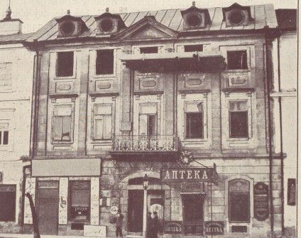

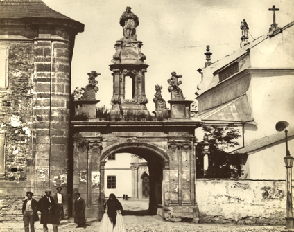
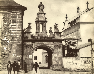


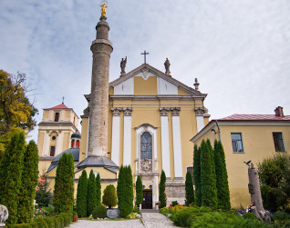

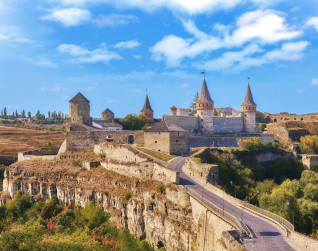
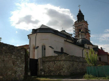


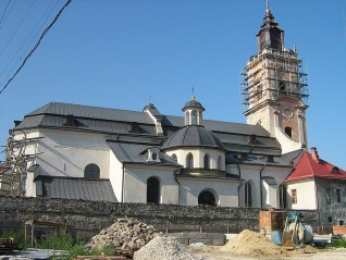


 Katalog poloników Show